Narrow Results By
Subject
- Buildings - Religious - Churches 10
- Buildings - Schools 16
- Businesses - Real Estate Agencies 1
- Documentary Artifacts - Certificates 1
- Events - May Day 2
- First Nations reserves - British Columbia 3
- Government - Federal Government 1
- Government - Provincial Government 1
- Indigenous peoples - Indian Territory 3
- Organizations - Boys' Societies and Clubs 1
- Organizations - Girls' Societies and Clubs 3
Creator
- British Columbia Fruit Growers' Association 1
- Burnett and McGugan B.C. Land Surveyors, New Westminster 5
- Burnett, Geoffrey K. 5
- Burnett & McGugan, Engineers and Surveyors 20
- Coast Map and Blue Print Co. 1
- Cooke, James Francis, 1875-1960 2
- Garden, Hermon and Burwell 2
- Gauvreau, Narcisse B. 1
- Geoffrey K. Burnett 1
- Hill, Albert James 5
- Hill & Burnett 5
- Leibly & Blumer Realty Co. Incorporated 1
Person / Organization
- All Saints Anglican Church 2
- Armstrong Avenue School 1
- Barnet School 1
- Boy Scouts of Canada 1
- Broadview Presbyterian Church 1
- Burnett, Geoffrey K. 2
- Co-operative Commonwealth Federation "CCF" 1
- Douglas Road School 1
- Douglas, Tommy 1
- Dundonald United Church 1
- Edmonds Community School 2
- Gilmore Avenue School 1
![Map of location of Toishan Middle school, [between 1919 and 1926] thumbnail](/media/hpo/_Data/_BVM_Cartographic_Material/1985/1985_5331_0009_002%20Web.jpg?width=280)
Map of location of Toishan Middle school
https://search.heritageburnaby.ca/link/museumdescription8695
- Repository
- Burnaby Village Museum
- Date
- [between 1919 and 1926]
- Collection/Fonds
- Way Sang Yuen Wat Kee & Co. fonds
- Description Level
- Item
- Physical Description
- 1 map : blueprint ink on paper ; 41.5 x 25.5 cm
- Scope and Content
- Item consists of a topographic map with Chinese characters indicating the location of where the Toishan Middle school will be constructed. Overseas Chinese who originated from Toishan county in China participated in the fundraising efforts for the first phase of building this school (there were thr…
- Repository
- Burnaby Village Museum
- Collection/Fonds
- Way Sang Yuen Wat Kee & Co. fonds
- Description Level
- Item
- Physical Description
- 1 map : blueprint ink on paper ; 41.5 x 25.5 cm
- Material Details
- Map details include elevation contours, marsh, roads, water and rail
- Scope and Content
- Item consists of a topographic map with Chinese characters indicating the location of where the Toishan Middle school will be constructed. Overseas Chinese who originated from Toishan county in China participated in the fundraising efforts for the first phase of building this school (there were three phases in total). The block of text on the bottom right describes the geographical location of the school. It also mentions some of the amenities that they want to add to the school grounds, which requires additional funding.
- Subjects
- Buildings - Schools
- Accession Code
- BV985.5331.9
- Access Restriction
- No restrictions
- Reproduction Restriction
- No known restrictions
- Date
- [between 1919 and 1926]
- Media Type
- Cartographic Material
- Scan Resolution
- 300
- Scan Date
- December 2020
- Scale
- 100
- Notes
- Title based on contents of map
Images
![Map of location of Toishan Middle school, [between 1919 and 1926] thumbnail](/media/hpo/_Data/_BVM_Cartographic_Material/1985/1985_5331_0009_002%20Web.jpg)
Memorial cards for Thomas Robert Love
https://search.heritageburnaby.ca/link/museumdescription10092
- Repository
- Burnaby Village Museum
- Date
- 1918
- Collection/Fonds
- Love family fonds
- Description Level
- File
- Physical Description
- 1 folder of textual records
- Scope and Content
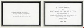
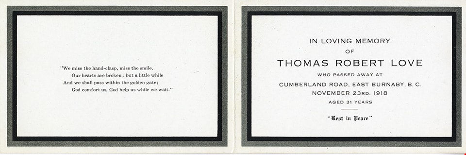
- File consists of three memorial cards for Thomas Richard Love which read: "IN LOVING MEMORY / OF / THOMAS ROBERT LOVE / WHO PASSED AWAY AT / CUMBERLAND ROAD, EAST BURNABY, B.C. / NOVEMBER 23RD. 1918 / AGED 31 YEARS / Rest in Peace".A short, religious poem is printed on the inside face of the card. …
- Repository
- Burnaby Village Museum
- Collection/Fonds
- Love family fonds
- Description Level
- File
- Physical Description
- 1 folder of textual records
- Scope and Content
- File consists of three memorial cards for Thomas Richard Love which read: "IN LOVING MEMORY / OF / THOMAS ROBERT LOVE / WHO PASSED AWAY AT / CUMBERLAND ROAD, EAST BURNABY, B.C. / NOVEMBER 23RD. 1918 / AGED 31 YEARS / Rest in Peace".A short, religious poem is printed on the inside face of the card. "MADE IN ENGLAND" is printed very small in the lower right hand corner of the back of the card. Thomas Robert Love served in World War I and was a victim of the 1918 flu epidemic.
- History
- See extensive history of Love Family and Love farmhouse located at Burnaby Village Museum.
- Accession Code
- BV012.31.24
- Access Restriction
- No restrictions
- Reproduction Restriction
- No known restrictions
- Date
- 1918
- Media Type
- Textual Record
- Scan Resolution
- 600
- Scan Date
- 7-May-20
- Scale
- 100
- Notes
- Title based on content of file
Images
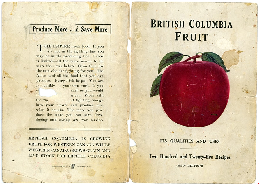
British Columbia fruit : its qualities and uses
https://search.heritageburnaby.ca/link/museumlibrary3822
- Repository
- Burnaby Village Museum
- Edition
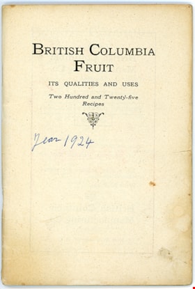
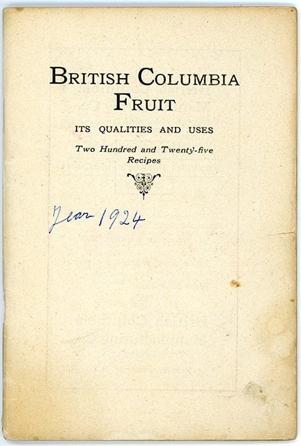
- New ed.
- 1918 ed.
- Publication Date
- 1918
- Call Number
- 641.64 BRI
- Repository
- Burnaby Village Museum
- Collection
- Special Collection
- Material Type
- Textual Record
- Accession Code
- BV004.2.2
- Call Number
- 641.64 BRI
- Edition
- New ed.
- 1918 ed.
- Place of Publication
- Vancouver
- Publisher
- British Columbia Fruit Growers' Association
- Publication Date
- 1918
- Printer
- The Sun Job Presses
- Physical Description
- 80 p. : ill. : 18 cm.
- Inscription
- "Year 1924" [Handwritten in blue ink on title page]
- Library Subject (LOC)
- Recipes
- Cooking--British Columbia
- Cookbooks--1910-1919
- Fruit
- Notes
- "Two Hundred and Twenty-five Recipes" -- Title page
Images

The listening post, no. 29
https://search.heritageburnaby.ca/link/museumlibrary6786
- Repository
- Burnaby Village Museum
- Collection
- Special Collection
- Material Type
- Textual Record
- Accession Code
- BV016.48.7
- Call Number
- 355 LIS
- Publication Date
- 1917
- Physical Description
- 47 p. : ill. ; 33 cm.
- Inscription
- 3
- Library Subject (LOC)
- Canada--Politics and government
- Military art and science--Canada
- Canada--History, Military
- World War, 1914-1918
- Periodicals
- Object History
- Military documents and memorabilia of First World War activities of Russell William Mawhinney. Later career of Mr Mawhinney as a Pharmacist in the Dunbar neighbourhood of Vancouver. Papers and memorabilia relating to Mr Mawhinney as an organizer of the Ex RAF Officers Association.
- Notes
- "Special Xmas Number"
Images


Kingsway East School
https://search.heritageburnaby.ca/link/museumdescription11121
- Repository
- Burnaby Village Museum
- Date
- April 27, 1915
- Collection/Fonds
- Ronald G. Scobbie collection
- Description Level
- Item
- Physical Description
- 1 survey plan : blueprint on paper ; 56 x 54 cm
- Scope and Content
- Survey plan of "Kingsway East School Site" "Burnaby Municipality" / "Lot 10, of the Subdivision of Lot "D" of... Lot 96, Group 1, New Westminster District"
- Repository
- Burnaby Village Museum
- Collection/Fonds
- Ronald G. Scobbie collection
- Description Level
- Item
- Physical Description
- 1 survey plan : blueprint on paper ; 56 x 54 cm
- Material Details
- Scale: 40 feet = 1 inch
- Scope and Content
- Survey plan of "Kingsway East School Site" "Burnaby Municipality" / "Lot 10, of the Subdivision of Lot "D" of... Lot 96, Group 1, New Westminster District"
- Subjects
- Buildings - Schools
- Names
- Kingsway East School
- Geographic Access
- Kingsway
- Mission Avenue
- Street Address
- 6650 Southoaks Crescent
- Accession Code
- BV003.83.1
- Access Restriction
- No restrictions
- Reproduction Restriction
- No known restrictions
- Date
- April 27, 1915
- Media Type
- Cartographic Material
- Historic Neighbourhood
- Edmonds (Historic Neighbourhood)
- Planning Study Area
- Kingsway-Beresford Area
- Scan Resolution
- 440
- Scan Date
- 22-Dec-2020
- Scale
- 100
- Notes
- Title based on contents of plan
- handwritten on back, "1753"
- signed "Geoffrey Burnett"; notarized, signature illegible
- "Oath of I, Geoffrey K. Burnett...did personally superintend the survey..." "Survey was completed on the 27th day of April 1915.
Zoomable Images


Kingsway West School site
https://search.heritageburnaby.ca/link/museumdescription11122
- Repository
- Burnaby Village Museum
- Date
- March 16, 1915
- Collection/Fonds
- Ronald G. Scobbie collection
- Description Level
- Item
- Physical Description
- 1 survey plan : blueprint on paper with pencil notations ; 56 x 54 cm
- Scope and Content
- Survey plan of "Kingsway West School Site" "Burnaby Municipality" "being Lot 1, D.L.32, Lot 1 of Lot 21, Portion of Lot 21 and Portion of Lot 20, of subdivision of D.L.152, 153 & Portion of Lot 151, Group 1, New Westminster District". Notations in pencil extend along the south boundary line of Dist…
- Repository
- Burnaby Village Museum
- Collection/Fonds
- Ronald G. Scobbie collection
- Description Level
- Item
- Physical Description
- 1 survey plan : blueprint on paper with pencil notations ; 56 x 54 cm
- Material Details
- Scale: 40 feet = 1 inch
- Scope and Content
- Survey plan of "Kingsway West School Site" "Burnaby Municipality" "being Lot 1, D.L.32, Lot 1 of Lot 21, Portion of Lot 21 and Portion of Lot 20, of subdivision of D.L.152, 153 & Portion of Lot 151, Group 1, New Westminster District". Notations in pencil extend along the south boundary line of District Lot 32.
- Creator
- McGugan, Donald Johnston
- Subjects
- Buildings - Schools
- Names
- Kingsway West School
- Responsibility
- Burnett and McGugan B.C. Land Surveyors, New Westminster
- Geographic Access
- Kingsway
- Sussex Avenue
- Accession Code
- BV003.83.2
- Access Restriction
- No restrictions
- Reproduction Restriction
- No known restrictions
- Date
- March 16, 1915
- Media Type
- Cartographic Material
- Historic Neighbourhood
- Central Park (Historic Neighbourhood)
- Planning Study Area
- Maywood Area
- Scan Resolution
- 440
- Scan Date
- 22-Dec-2020
- Scale
- 100
- Notes
- Transcribed title
- Oath in bottom left corner reads: "I, D.J. McGugan...did personally superintend the survey ..." "...completed on the 16th day of March 1915", signed "D.J. McGugan" and is notarized on March 19th, 1915 by "S.F. Frank" with a seal
- handwritten on back, "1753";
- See also BV003.83.9 - duplicate blueprint plan without annotations
- See also BV003.83.3 for original plan on waxed linen
Zoomable Images


Howard Avenue School site
https://search.heritageburnaby.ca/link/museumdescription11124
- Repository
- Burnaby Village Museum
- Date
- March 24, 1915
- Collection/Fonds
- Ronald G. Scobbie collection
- Description Level
- Item
- Physical Description
- 1 survey plan : blueprint on paper ; 56 x 54 cm
- Scope and Content
- Survey plan of "Howard Avenue School Site" "Burnaby Municipality", "Being Lots 1-5 and 14-18 Inc. Block 5 of the Subd. of Easterly 3/4 of Lot 127. Group 1, New Westminster District";
- Repository
- Burnaby Village Museum
- Collection/Fonds
- Ronald G. Scobbie collection
- Description Level
- Item
- Physical Description
- 1 survey plan : blueprint on paper ; 56 x 54 cm
- Material Details
- Scale: 40 feet = 1 inch
- Scope and Content
- Survey plan of "Howard Avenue School Site" "Burnaby Municipality", "Being Lots 1-5 and 14-18 Inc. Block 5 of the Subd. of Easterly 3/4 of Lot 127. Group 1, New Westminster District";
- Creator
- McGugan, Donald Johnston
- Subjects
- Buildings - Schools
- Names
- Howard Avenue School
- Responsibility
- Burnett and McGugan B.C. Land Surveyors, New Westminster
- Geographic Access
- Howard Avenue
- Georgia Street
- Accession Code
- BV003.83.4
- Access Restriction
- No restrictions
- Reproduction Restriction
- No known restrictions
- Date
- March 24, 1915
- Media Type
- Cartographic Material
- Historic Neighbourhood
- Capitol Hill (Historic Neighbourhood)
- Planning Study Area
- Capitol Hill Area
- Scan Resolution
- 440
- Scan Date
- 22-Dec-2020
- Scale
- 100
- Notes
- Title based on contents of plan
- Oath in bottom left corner reads: "I, D.J. McGugan...and did personally superintend the survey..." "...completed on the 24th day of March 1915"; signed "D.J. McGugan", notarized on April 12th, 1915 by "R. Chapman"
- handwritten on back, "1754"
Zoomable Images


Edmonds Street School site
https://search.heritageburnaby.ca/link/museumdescription11125
- Repository
- Burnaby Village Museum
- Date
- March 8, 1915
- Collection/Fonds
- Ronald G. Scobbie collection
- Description Level
- Item
- Physical Description
- 1 survey plan : blueprint on paper ; 56 x 54 cm
- Scope and Content
- Survey plan of "Edmonds Street School Site" "Burnaby Municipality" "Being Lots 28 and 29 of the Subdivision of Lot 30, Group 1, New Westminster District";
- Repository
- Burnaby Village Museum
- Collection/Fonds
- Ronald G. Scobbie collection
- Description Level
- Item
- Physical Description
- 1 survey plan : blueprint on paper ; 56 x 54 cm
- Material Details
- Scale: 4 feet = 1 inch
- Scope and Content
- Survey plan of "Edmonds Street School Site" "Burnaby Municipality" "Being Lots 28 and 29 of the Subdivision of Lot 30, Group 1, New Westminster District";
- Subjects
- Buildings - Schools
- Names
- Edmonds Community School
- Responsibility
- Burnett and McGugan B.C. Land Surveyors, New Westminster
- Geographic Access
- Edmonds Street
- Street Address
- 7641 Edmonds Street
- Accession Code
- BV003.83.5
- Access Restriction
- No restrictions
- Reproduction Restriction
- No known restrictions
- Date
- March 8, 1915
- Media Type
- Cartographic Material
- Historic Neighbourhood
- Edmonds (Historic Neighbourhood)
- Planning Study Area
- Edmonds Area
- Scan Resolution
- 440
- Scan Date
- 22-Dec-2020
- Scale
- 100
- Notes
- Title based on contents of plan
- Oath in bottom left corner reads: "I, D.J. McGugan...and did personally superintend the survey..." "...completed on the 8th day of March 1915"; signed "D.J. McGugan", notarized by "S.F. Mark" "sworn...12th Day of April 1915"
- handwritten on back, "1756"
Zoomable Images


Inman Avenue School site
https://search.heritageburnaby.ca/link/museumdescription11128
- Repository
- Burnaby Village Museum
- Date
- May 3, 1915
- Collection/Fonds
- Ronald G. Scobbie collection
- Description Level
- Item
- Physical Description
- 1 survey plan : blueprint on paper ; 56 x 54 cm
- Scope and Content
- Survey plan of "Inman Avenue School Site" "Burnaby Municipality" "Being Lots 3 -12 inc. Blk. C. of Subd. of Blks.5" "13-19 inc. & 21-28 inc. of Subd. of Westerly 80 Acres of, and portion of D.L. 34, Group One. New Westminster District".
- Repository
- Burnaby Village Museum
- Collection/Fonds
- Ronald G. Scobbie collection
- Description Level
- Item
- Physical Description
- 1 survey plan : blueprint on paper ; 56 x 54 cm
- Material Details
- Scale: 40 feet = 1 inch
- Scope and Content
- Survey plan of "Inman Avenue School Site" "Burnaby Municipality" "Being Lots 3 -12 inc. Blk. C. of Subd. of Blks.5" "13-19 inc. & 21-28 inc. of Subd. of Westerly 80 Acres of, and portion of D.L. 34, Group One. New Westminster District".
- Creator
- McGugan, Donald Johnston
- Subjects
- Buildings - Schools
- Names
- Inman Avenue School
- Responsibility
- Burnett & McGugan, Engineers and Surveyors
- Geographic Access
- Brandon Street
- Street Address
- 3963 Brandon Street
- Accession Code
- BV003.83.7
- Access Restriction
- No restrictions
- Reproduction Restriction
- No known restrictions
- Date
- May 3, 1915
- Media Type
- Cartographic Material
- Historic Neighbourhood
- Central Park (Historic Neighbourhood)
- Planning Study Area
- Garden Village Area
- Scan Resolution
- 440
- Scan Date
- 22-Dec-2020
- Scale
- 100
- Notes
- Title based on contents of plan
- Oath in bottom left corner reads: "I, D.J. McGugan...did...superintend the survey...", "...completed on the 3rd day of May 1915"; signed "D.J. McGugan", notariz- ed by "Walter Edmonds" "sworn...22nd Day of May 1915"; "Burnett and McGugan. B.C. Land Surveyors. Etc. New Westminster. B.C.";
- handwritten note reads: "Note: Before using this Mon. see plan / of resubdivision of Lots 5 & 6 / of Block 'B' D.L. 34 / June 1945"
- handwritten twice on back, "1776"
Zoomable Images


Gilmour Avenue School site
https://search.heritageburnaby.ca/link/museumdescription11129
- Repository
- Burnaby Village Museum
- Date
- May 27, 1915
- Collection/Fonds
- Ronald G. Scobbie collection
- Description Level
- Item
- Physical Description
- 1 survey plan : blueprint on paper ; 56 x 54 cm
- Scope and Content
- Survey plan of Gilmore Avenue School site. Title on plan reads: "Gilmour Avenue School Site / Burnaby Municipality / Being Lots 1-10 inc. & Lots 27-36 inc. of Block 9 / of Subdivision of a Portion of Lot 187, GP.1 / New Westminster District". "Note. School site is as shown below, the original...am…
- Repository
- Burnaby Village Museum
- Collection/Fonds
- Ronald G. Scobbie collection
- Description Level
- Item
- Physical Description
- 1 survey plan : blueprint on paper ; 56 x 54 cm
- Material Details
- Scale: 40 feet = 1 inch
- Scope and Content
- Survey plan of Gilmore Avenue School site. Title on plan reads: "Gilmour Avenue School Site / Burnaby Municipality / Being Lots 1-10 inc. & Lots 27-36 inc. of Block 9 / of Subdivision of a Portion of Lot 187, GP.1 / New Westminster District". "Note. School site is as shown below, the original...amended" "by cancelling Lots 1-10 & 27-30 inc....order of court filed No.4938".
- History
- The school was named after Hugh B. Gilmour, but an error by a municipal clerk in the Street Naming Bylaw in 1912 (Bylaw Number 135) changed the spelling to "Gilmore" Avenue and the school name was spelled "Gilmore" Avenue School hereafter.
- Creator
- McGugan, Donald Johnston
- Subjects
- Buildings - Schools
- Names
- Gilmore Avenue School
- Responsibility
- Burnett & McGugan, Engineers and Surveyors
- Geographic Access
- Gilmore Avenue
- Accession Code
- BV003.83.8
- Access Restriction
- No restrictions
- Reproduction Restriction
- No known restrictions
- Date
- May 27, 1915
- Media Type
- Cartographic Material
- Historic Neighbourhood
- Vancouver Heights (Historic Neighbourhood)
- Planning Study Area
- Willingdon Heights Area
- Scan Resolution
- 440
- Scan Date
- 22-Dec-2020
- Scale
- 100
- Notes
- Transcribed title taken from plan
- Oath in bottom left corner reads: "I, D.J. McGugan...did superintend the survey", "...completed on the 27th day of May 1915" and noterized by Walter Edmonds" "sworn...29th Day of May 1915"; "Burnett and McGugan. B.C. Land Surveyors Etc. New Westminster. B.C."
- Note in black ink on verso of plan reads: "1782"
Zoomable Images


Armstrong Street School site
https://search.heritageburnaby.ca/link/museumdescription11133
- Repository
- Burnaby Village Museum
- Date
- 1915
- Collection/Fonds
- Ronald G. Scobbie collection
- Description Level
- Item
- Physical Description
- 1 survey plan : blueprint on paper ; 56 x 54 cm
- Scope and Content
- Survey plan of "Armstrong Street School Site / Burnaby Municipality" "Being a 2 acre portion of Lot 13 Group 1, & according to map 1722 which shows this as Lot E. Block 2 of subdivision of a portion, of Lot 13, Group 1, New Westminster District".
- Repository
- Burnaby Village Museum
- Collection/Fonds
- Ronald G. Scobbie collection
- Description Level
- Item
- Physical Description
- 1 survey plan : blueprint on paper ; 56 x 54 cm
- Material Details
- Scale 40 feet = 1 inch
- Scope and Content
- Survey plan of "Armstrong Street School Site / Burnaby Municipality" "Being a 2 acre portion of Lot 13 Group 1, & according to map 1722 which shows this as Lot E. Block 2 of subdivision of a portion, of Lot 13, Group 1, New Westminster District".
- Creator
- Burnett, Geoffrey K.
- Subjects
- Buildings - Schools
- Names
- Armstrong Avenue School
- Responsibility
- Burnett & McGugan, Engineers and Surveyors
- Geographic Access
- Armstrong Avenue
- Street Address
- 8757 Armstrong Avenue
- Accession Code
- BV003.83.12
- Access Restriction
- No restrictions
- Reproduction Restriction
- No known restrictions
- Date
- 1915
- Media Type
- Cartographic Material
- Historic Neighbourhood
- East Burnaby (Historic Neighbourhood)
- Planning Study Area
- Cariboo-Armstrong Area
- Scan Resolution
- 440
- Scan Date
- 22-Dec-2020
- Scale
- 100
- Notes
- Title based on contents of plan
- Note in black ink on verso of plan reads: "1746"
- Oath on plan reads: "I, Geoffrey K. Burnett...and did personally superintend the survey represented..." "Completed on the 18th day of March 1915"; signed by Geoffrey K. Burnett and notarized by "K.A. Eastman", sworn "...19th day of April 1915"; "Burnett and McGugan., B.C. Land Surveyors. Etc.. New Westminster, B.C.."
Zoomable Images


Riverway School site
https://search.heritageburnaby.ca/link/museumdescription11134
- Repository
- Burnaby Village Museum
- Date
- April 16, 1915
- Collection/Fonds
- Ronald G. Scobbie collection
- Description Level
- Item
- Physical Description
- 1 survey plan : blueprint on paper ; 56 x 54 cm
- Scope and Content
- Survey plan of "Riverway School Site / Burnaby Municipality" "Being a 1 acre portion of Lot 159 Group 1, and Lots 30 & 31 of subd. of Bks. 1, 1a, 2, 3, 4 & 5 of Lot 159, Group 1, New Westminster District".
- Repository
- Burnaby Village Museum
- Collection/Fonds
- Ronald G. Scobbie collection
- Description Level
- Item
- Physical Description
- 1 survey plan : blueprint on paper ; 56 x 54 cm
- Material Details
- Scale 40 feet = 1 inch
- Scope and Content
- Survey plan of "Riverway School Site / Burnaby Municipality" "Being a 1 acre portion of Lot 159 Group 1, and Lots 30 & 31 of subd. of Bks. 1, 1a, 2, 3, 4 & 5 of Lot 159, Group 1, New Westminster District".
- Creator
- Geoffrey K. Burnett
- Subjects
- Buildings - Schools
- Names
- Riverway East School
- Responsibility
- Burnett and McGugan B.C. Land Surveyors, New Westminster
- Geographic Access
- Gilley Avenue
- Marine Drive
- Street Address
- 5787 Marine Drive
- Accession Code
- BV003.83.13
- Access Restriction
- No restrictions
- Reproduction Restriction
- No known restrictions
- Date
- April 16, 1915
- Media Type
- Cartographic Material
- Historic Neighbourhood
- Alta Vista (Historic Neighbourhood)
- Planning Study Area
- Clinton-Glenwood Area
- Scan Resolution
- 440
- Scan Date
- 22-Dec-2020
- Scale
- 100
- Notes
- Title based on contents of plan
- Note in black ink on verso of plan reads: "1744" / "Riverway School"
- Oath on plan reads: "I, Geoffrey K. Burnett...and did personally superintend the survey..." "...completed on the 16th day of April 1915"; signed by Geoffrey K. Burnett and notarized by "K.A. Eastman", sworn "...19th day of April 1915"
Zoomable Images


Nelson Avenue School site
https://search.heritageburnaby.ca/link/museumdescription11135
- Repository
- Burnaby Village Museum
- Date
- April 12, 1915
- Collection/Fonds
- Ronald G. Scobbie collection
- Description Level
- Item
- Physical Description
- 1 survey plan : blueprint on paper ; 56 x 54 cm
- Scope and Content
- Survey plan of "Nelson Avenue School Site / Burnaby Municipality" "Being the south half of Block 19, except therefrom the north 33 feet, of Lot 99, Gp. 1. New Westminster District".
- Repository
- Burnaby Village Museum
- Collection/Fonds
- Ronald G. Scobbie collection
- Description Level
- Item
- Physical Description
- 1 survey plan : blueprint on paper ; 56 x 54 cm
- Material Details
- Scale 40 feet = 1 inch
- Scope and Content
- Survey plan of "Nelson Avenue School Site / Burnaby Municipality" "Being the south half of Block 19, except therefrom the north 33 feet, of Lot 99, Gp. 1. New Westminster District".
- Creator
- McGugan, Donald Johnston
- Subjects
- Buildings - Schools
- Names
- Nelson Avenue School
- Responsibility
- Burnett & McGugan, Engineers and Surveyors
- Geographic Access
- Irmin Street
- Street Address
- 4850 Irmin Street
- Accession Code
- BV003.83.14
- Access Restriction
- No restrictions
- Reproduction Restriction
- No known restrictions
- Date
- April 12, 1915
- Media Type
- Cartographic Material
- Historic Neighbourhood
- Alta Vista (Historic Neighbourhood)
- Planning Study Area
- Sussex-Nelson Area
- Scan Resolution
- 440
- Scan Date
- 22-Dec-2020
- Scale
- 100
- Notes
- Title based on contents of plan
- Note in black ink on verso of plan reads: "1745"
- Oath on plan reads: "I, D.G. McGugan..." "...and did person- ally superintend the survey..." "...completed on the 5th day of March 1915"; signed by D.J. McGugan, notarized by "R.E. Chapman", sworn "...12th day of April 1915" "Burnett and McGugan" "B.C. Land Surveyors Etc. New Westminster, B.C.."
Images


Douglas Road School site
https://search.heritageburnaby.ca/link/museumdescription11136
- Repository
- Burnaby Village Museum
- Date
- April 19, 1915
- Collection/Fonds
- Ronald G. Scobbie collection
- Description Level
- Item
- Physical Description
- 1 survey plan : blueprint on paper ; 56 x 54 cm
- Scope and Content
- Survey plan of "Douglas Road School Site / Burnaby Municipality" "Being Lot 21, of Blocks 1-5 inc. 11 & 12 of the subd. of north half of Lot 80, Group 1, New Westminster District".
- Repository
- Burnaby Village Museum
- Collection/Fonds
- Ronald G. Scobbie collection
- Description Level
- Item
- Physical Description
- 1 survey plan : blueprint on paper ; 56 x 54 cm
- Material Details
- Scale 40 feet = 1 inch
- Scope and Content
- Survey plan of "Douglas Road School Site / Burnaby Municipality" "Being Lot 21, of Blocks 1-5 inc. 11 & 12 of the subd. of north half of Lot 80, Group 1, New Westminster District".
- Creator
- McGugan, Donald Johnston
- Subjects
- Buildings - Schools
- Names
- Douglas Road School
- Responsibility
- Burnett & McGugan, Engineers and Surveyors
- Geographic Access
- Canada Way
- Street Address
- 4861 Canada Way
- Accession Code
- BV003.83.15
- Access Restriction
- No restrictions
- Reproduction Restriction
- No known restrictions
- Date
- April 19, 1915
- Media Type
- Cartographic Material
- Historic Neighbourhood
- Burnaby Lake (Historic Neighbourhood)
- Planning Study Area
- Douglas-Gilpin Area
- Scan Resolution
- 440
- Scan Date
- 22-Dec-2020
- Scale
- 100
- Notes
- Title based on contents of plan
- Note in black ink on verso of plan reads: "1747"
- Oath on plan reads: "I, D.G. McGugan..." "...and did person- ally superintend the survey..." "...completed on the 3rd day of April 1915"; signed by D.J. McGugan, notarized by "H.A. Eastman", sworn "...19th day of April 1915" "Burnett and McGugan" "B.C. Land Surveyors Etc. New Westminster, B.C.."
Images


Sperling Avenue School site
https://search.heritageburnaby.ca/link/museumdescription11137
- Repository
- Burnaby Village Museum
- Date
- March 8, 1915
- Collection/Fonds
- Ronald G. Scobbie collection
- Description Level
- Item
- Physical Description
- 1 survey plan : blueprint on paper ; 56 x 54 cm
- Scope and Content
- Survey plan of "Sperling Avenue School Site / Burnaby Municipality" "Being a 4.11 acre portion of the south half of Block 7 of subd. part of Lot 131, Grroup 1" "New Westminster District".
- Repository
- Burnaby Village Museum
- Collection/Fonds
- Ronald G. Scobbie collection
- Description Level
- Item
- Physical Description
- 1 survey plan : blueprint on paper ; 56 x 54 cm
- Material Details
- Scale 40 feet = 1 inch
- Scope and Content
- Survey plan of "Sperling Avenue School Site / Burnaby Municipality" "Being a 4.11 acre portion of the south half of Block 7 of subd. part of Lot 131, Grroup 1" "New Westminster District".
- Creator
- McGugan, Donald Johnston
- Subjects
- Buildings - Schools
- Names
- Sperling Avenue School
- Responsibility
- Burnett & McGugan, Engineers and Surveyors
- Geographic Access
- Sperling Avenue
- Street Address
- 2200 Sperling Avenue
- Accession Code
- BV003.83.16
- Access Restriction
- No restrictions
- Reproduction Restriction
- No known restrictions
- Date
- March 8, 1915
- Media Type
- Cartographic Material
- Historic Neighbourhood
- Lochdale (Historic Neighbourhood)
- Planning Study Area
- Sperling-Broadway Area
- Scan Resolution
- 440
- Scan Date
- 22-Dec-2020
- Scale
- 100
- Notes
- Title based on contents of plan
- handwritten on back, "1748"
- Oath on plan reads: "I, D.G. McGugan..." "...person- ally superintend the survey..." "...completed on the 8th day of March 1915"; signed by D.J. McGugan, notarized by "R.E. Chapman", sworn "...12th day of April 1915" "Burnett and McGugan" "B.C. Land Surveyors Etc. New Westminster, B.C..";
Images


Schou Street School site
https://search.heritageburnaby.ca/link/museumdescription11138
- Repository
- Burnaby Village Museum
- Date
- April 12, 1915
- Collection/Fonds
- Ronald G. Scobbie collection
- Description Level
- Item
- Physical Description
- 1 survey plan : blueprint on paper ; 56 x 54 cm
- Scope and Content
- Survey plan of "Schou Street School Site / Burnaby Municipality" "Being Lot 1-12 inc. of Block 47, of subd. of Blocks 8-12 and 15-49 inclusive, Lot 69, Group 1" "New Westminster District";
- Repository
- Burnaby Village Museum
- Collection/Fonds
- Ronald G. Scobbie collection
- Description Level
- Item
- Physical Description
- 1 survey plan : blueprint on paper ; 56 x 54 cm
- Material Details
- Scale 40 feet = 1 inch
- Scope and Content
- Survey plan of "Schou Street School Site / Burnaby Municipality" "Being Lot 1-12 inc. of Block 47, of subd. of Blocks 8-12 and 15-49 inclusive, Lot 69, Group 1" "New Westminster District";
- Creator
- Burnett, Geoffrey K.
- Subjects
- Buildings - Schools
- Names
- Schou Street School
- Responsibility
- Burnett & McGugan, Engineers and Surveyors
- Geographic Access
- Canada Way
- Grandview Highway
- Gilmore Avenue
- Street Address
- 4054 Norfolk Street
- Accession Code
- BV003.83.17
- Access Restriction
- No restrictions
- Reproduction Restriction
- No known restrictions
- Date
- April 12, 1915
- Media Type
- Cartographic Material
- Historic Neighbourhood
- Broadview (Historic Neighbourhood)
- Planning Study Area
- Cascade-Schou Area
- Scan Resolution
- 440
- Scan Date
- 22-Dec-2020
- Scale
- 100
- Notes
- Title based on contents of plan
- Oath on plan reads: "I, Geoffrey K. Burnett...did person- ally superintend the survey..." "...completed on the 12th day of April 1915"; signed by Geoffrey K. Burnett, notarized by "S.F. Mark", sworn "..12th day.. April 1915" "Burnett and McGugan" "B.C. Land Surveyors Etc. New Westminster, B.C.
- ."handwritten on back, "1751"
- two school buildings are shown on this blueprint, "Old School Building", "New School Building"
Images


Hamilton Road School site
https://search.heritageburnaby.ca/link/museumdescription11139
- Repository
- Burnaby Village Museum
- Date
- April 27, 1915
- Collection/Fonds
- Ronald G. Scobbie collection
- Description Level
- Item
- Physical Description
- 1 survey plan : blueprint on paper ; 56 x 54 cm
- Scope and Content
- Survey plan of "Hamilton Road School Site / Burnaby Municipality" "Being the westerly 2 acres of Block 2 of the subd. of a portion of Lot 8, Group 1"; "New Westminster District”.
- Repository
- Burnaby Village Museum
- Collection/Fonds
- Ronald G. Scobbie collection
- Description Level
- Item
- Physical Description
- 1 survey plan : blueprint on paper ; 56 x 54 cm
- Material Details
- Scale 40 feet = 1 inch
- Scope and Content
- Survey plan of "Hamilton Road School Site / Burnaby Municipality" "Being the westerly 2 acres of Block 2 of the subd. of a portion of Lot 8, Group 1"; "New Westminster District”.
- Creator
- Burnett, Geoffrey K.
- Subjects
- Buildings - Schools
- Names
- Hamilton Road School
- Responsibility
- Burnett & McGugan, Engineers and Surveyors
- Geographic Access
- Lyndhurst Street
- Accession Code
- BV003.83.18
- Access Restriction
- No restrictions
- Reproduction Restriction
- No known restrictions
- Date
- April 27, 1915
- Media Type
- Cartographic Material
- Historic Neighbourhood
- Burquitlam (Historic Neighbourhood)
- Planning Study Area
- Sperling-Broadway Area
- Scan Resolution
- 440
- Scan Date
- 22-Dec-2020
- Scale
- 100
- Notes
- Title based on contents of plan
- handwritten on back, "1752" and mathematical calculations
- Oath on plan reads: "I, Geoffrey K. Burnett...and did person- ally superintend the survey..." "...completed on the 27th day of April 1915"; signed by Geoffrey K. Burnett, notary illegible, sworn "...27th day of April 1915" "Burnett and McGugan" "B.C. Land Surveyors Etc. New Westminster, B.C."
Images


Barnet School site
https://search.heritageburnaby.ca/link/museumdescription11140
- Repository
- Burnaby Village Museum
- Date
- May 27, 1915
- Collection/Fonds
- Ronald G. Scobbie collection
- Description Level
- Item
- Physical Description
- 1 survey plan : blueprint on paper ; 56 x 54 cm
- Scope and Content
- Survey plan of "Barnet School Site / Burnaby Municipality" "Being a portion of the west half of lot / 214, Group 1 / New Westminster District”.
- Repository
- Burnaby Village Museum
- Collection/Fonds
- Ronald G. Scobbie collection
- Description Level
- Item
- Physical Description
- 1 survey plan : blueprint on paper ; 56 x 54 cm
- Material Details
- Scale 40 feet = 1 inch
- Scope and Content
- Survey plan of "Barnet School Site / Burnaby Municipality" "Being a portion of the west half of lot / 214, Group 1 / New Westminster District”.
- Creator
- McGugan, Donald Johnston
- Subjects
- Buildings - Schools
- Names
- Barnet School
- Responsibility
- Burnett & McGugan, Engineers and Surveyors
- Geographic Access
- Barnet Road
- Street Address
- 7820 Barnet Road
- Accession Code
- BV003.83.19
- Access Restriction
- No restrictions
- Reproduction Restriction
- No known restrictions
- Date
- May 27, 1915
- Media Type
- Cartographic Material
- Historic Neighbourhood
- Barnet (Historic Neighbourhood)
- Planning Study Area
- Burnaby Mountain Area
- Scan Resolution
- 440
- Scan Date
- 22-Dec-2020
- Scale
- 100
- Notes
- Title based on contents of plan
- handwritten on back "Burnaby Schools" "23R" twice, "1783"
- Oath on plan reads: "I, D.J. McGugan...and did personally superintend the survey..." "completed on the 27th day of May 1915"; signed by D.J. McGugan, notarized by "Walter Edmonds" "sworn "...29th day of May 1915" "Burnett and McGugan" "B.C. Land Surveyors Etc. New Westminster, B.C.";
Zoomable Images


Second Street School site
https://search.heritageburnaby.ca/link/museumdescription11920
- Repository
- Burnaby Village Museum
- Date
- May 29, 1915
- Collection/Fonds
- Ronald G. Scobbie collection
- Description Level
- Item
- Physical Description
- 1 survey plan : blueprint on paper ; 56 x 54 cm
- Scope and Content
- Survey plan of "Second Street School Site" "Burnaby Municipality" "Being Lots 1 & 2 , Block 20 of the Subd of / Lot 27. Group 1 / New Westminster District".
- Repository
- Burnaby Village Museum
- Collection/Fonds
- Ronald G. Scobbie collection
- Description Level
- Item
- Physical Description
- 1 survey plan : blueprint on paper ; 56 x 54 cm
- Material Details
- Scale: 40 feet = 1 inch
- Scope and Content
- Survey plan of "Second Street School Site" "Burnaby Municipality" "Being Lots 1 & 2 , Block 20 of the Subd of / Lot 27. Group 1 / New Westminster District".
- Creator
- McGugan, Donald Johnston
- Subjects
- Buildings - Schools
- Names
- Edmonds Community School
- Responsibility
- Burnett and McGugan B.C. Land Surveyors, New Westminster
- Geographic Access
- Edmonds Street
- Street Address
- 7641 Edmonds Street
- Accession Code
- BV003.83.6
- Access Restriction
- No restrictions
- Reproduction Restriction
- No known restrictions
- Date
- May 29, 1915
- Media Type
- Cartographic Material
- Historic Neighbourhood
- Edmonds (Historic Neighbourhood)
- Planning Study Area
- Edmonds Area
- Scan Resolution
- 440
- Scan Date
- 22-Dec-2020
- Scale
- 100
- Notes
- Title based on contents of plan
- Oath in bottom left corner reads: "I, D.J. McGugan...and did personally superintend the survey..." "...completed on the 8th day of March 1915"; signed "D.J. McGugan / BCLS / sworn...29 day / of May 1915"
- handwritten on back, "1733"
Zoomable Images


Family and political photograph album
https://search.heritageburnaby.ca/link/museumdescription3654
- Repository
- Burnaby Village Museum
- Date
- 1914-1977
- Collection/Fonds
- Harold Edward Winch collection
- Description Level
- Item
- Physical Description
- 1 album (ca. 85 photographs)
- Scope and Content
- Item is a photograph album containing ca. 85 photographs, including both personal and work-related subjects such as the Winch family and homes, and Winch's political work and travels. Also included are some textual records relating to Winch's political work.
- Repository
- Burnaby Village Museum
- Collection/Fonds
- Harold Edward Winch collection
- Description Level
- Item
- Physical Description
- 1 album (ca. 85 photographs)
- Scope and Content
- Item is a photograph album containing ca. 85 photographs, including both personal and work-related subjects such as the Winch family and homes, and Winch's political work and travels. Also included are some textual records relating to Winch's political work.
- Names
- Winch, Harold Edward
- Winch, Linda Marian Hendy
- Winch, Grace
- Winch, Eileen
- Winch, Ernest "Ernie"
- Winch, Eric
- Co-operative Commonwealth Federation "CCF"
- New Democratic Party
- Douglas, Tommy
- MacInnis, Grace
- Accession Code
- BV013.12.11
- Date
- 1914-1977
- Media Type
- Photograph
- Textual Record
- Notes
- Title based on contents of photograph
- A selection of photographs from scrapbook have been described at item level (BV013.12.36 to BV015.35.117)
Images
