Narrow Results By
Subject
- Accidents 1
- Accidents - Train Accidents 6
- Adminstrative Groups - Committees 4
- Adornment - Jewelry 1
- Advertising Medium 1
- Advertising Medium - Flyer 4
- Advertising Medium - Poster 15
- Advertising Medium - Signs and Signboards 73
- Aerial Photographs
- Agriculture - Farms 57
- Agriculture - Fruit and Berries
- Agriculture - Poultry 1
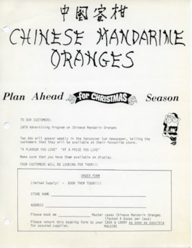
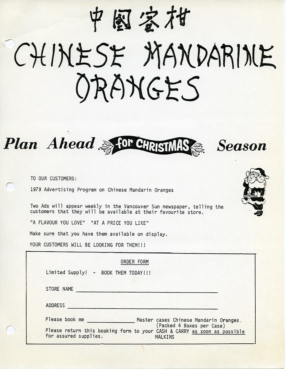
Advertising flyer and order form for Chinese mandarin oranges
https://search.heritageburnaby.ca/link/museumdescription14878
- Repository
- Burnaby Village Museum
- Date
- 1979
- Collection/Fonds
- Julie Lee and Cecil Lee family fonds
- Description Level
- Item
- Physical Description
- 1 p.
- Scope and Content
- Item consists of a one page advertising flyer and order form to customers of W.H. Malkins "1979 Advertising program on Chinese Mandarin Oranges". The flyer includes the title in English and Chinese "Chinese Mandarin Oranges".
- Repository
- Burnaby Village Museum
- Collection/Fonds
- Julie Lee and Cecil Lee family fonds
- Description Level
- Item
- Physical Description
- 1 p.
- Scope and Content
- Item consists of a one page advertising flyer and order form to customers of W.H. Malkins "1979 Advertising program on Chinese Mandarin Oranges". The flyer includes the title in English and Chinese "Chinese Mandarin Oranges".
- Subjects
- Agriculture - Fruit and Berries
- Foods
- Documentary Artifacts - Leaflets
- Buildings - Commercial - Grocery Stores
- Accession Code
- BV019.6.107
- Access Restriction
- No restrictions
- Reproduction Restriction
- May be restricted by third party rights
- Date
- 1979
- Media Type
- Textual Record
- Scan Resolution
- 600
- Scan Date
- 3-Nov-2020
- Scale
- 100
- Notes
- Title based on content of item
- Item is part of a scrapbook album created by Cecil Lee
Images

Aerial view from Central Park
https://search.heritageburnaby.ca/link/archivedescription78855
- Repository
- City of Burnaby Archives
- Date
- September 27, 1976
- Collection/Fonds
- Burnaby Public Library Contemporary Visual Archive Project
- Description Level
- Item
- Physical Description
- 1 photograph : b&w ; 11 x 16 cm mounted on cardboard
- Scope and Content
- Photograph is an aerial view looking northeast from Central Park with Forest Lawn Memorial Park and Deer Lake in the background.
- Repository
- City of Burnaby Archives
- Date
- September 27, 1976
- Collection/Fonds
- Burnaby Public Library Contemporary Visual Archive Project
- Physical Description
- 1 photograph : b&w ; 11 x 16 cm mounted on cardboard
- Description Level
- Item
- Record No.
- 556-003
- Access Restriction
- No restrictions
- Reproduction Restriction
- Reproduce for fair dealing purposes only
- Accession Number
- 2013-13
- Scope and Content
- Photograph is an aerial view looking northeast from Central Park with Forest Lawn Memorial Park and Deer Lake in the background.
- Subjects
- Aerial Photographs
- Media Type
- Photograph
- Photographer
- Norton, Paul
- Notes
- Scope note taken directly from BPL photograph description.
- 1 b&w copy negative : 10 x 12.5 cm accompanying
- Planning Study Area
- Windsor Area
- Douglas-Gilpin Area
Images


Aerial view looking east on Kingsway
https://search.heritageburnaby.ca/link/archivedescription78857
- Repository
- City of Burnaby Archives
- Date
- September 15, 1976
- Collection/Fonds
- Burnaby Public Library Contemporary Visual Archive Project
- Description Level
- Item
- Physical Description
- 1 photograph : b&w ; 11 x 16 cm mounted on cardboard
- Scope and Content
- Photograph is an aerial view looking east on Kingsway, taken from the twenty-first floor of the Panorama Towers on Grange Street, with Sears and Kelly Douglas in the background.
- Repository
- City of Burnaby Archives
- Date
- September 15, 1976
- Collection/Fonds
- Burnaby Public Library Contemporary Visual Archive Project
- Physical Description
- 1 photograph : b&w ; 11 x 16 cm mounted on cardboard
- Description Level
- Item
- Record No.
- 556-004
- Access Restriction
- No restrictions
- Reproduction Restriction
- Reproduce for fair dealing purposes only
- Accession Number
- 2013-13
- Scope and Content
- Photograph is an aerial view looking east on Kingsway, taken from the twenty-first floor of the Panorama Towers on Grange Street, with Sears and Kelly Douglas in the background.
- Subjects
- Aerial Photographs
- Media Type
- Photograph
- Photographer
- McCarron, John
- Notes
- Scope note taken directly from BPL photograph description.
- 1 b&w copy negative : 10 x 12.5 cm accompanying
- Geographic Access
- Kingsway
- Grange Street
- Historic Neighbourhood
- Central Park (Historic Neighbourhood)
- Planning Study Area
- Maywood Area
- Garden Village Area
Images


Aerial view of Capitol Hill
https://search.heritageburnaby.ca/link/archivedescription78854
- Repository
- City of Burnaby Archives
- Date
- October 14, 1976
- Collection/Fonds
- Burnaby Public Library Contemporary Visual Archive Project
- Description Level
- Item
- Physical Description
- 1 photograph : b&w ; 11 x 16 cm mounted on cardboard
- Scope and Content
- Photograph is an aerial view of Capitol Hill, looking northeast from the Burnaby General Hospital
- Repository
- City of Burnaby Archives
- Date
- October 14, 1976
- Collection/Fonds
- Burnaby Public Library Contemporary Visual Archive Project
- Physical Description
- 1 photograph : b&w ; 11 x 16 cm mounted on cardboard
- Description Level
- Item
- Record No.
- 556-002
- Access Restriction
- No restrictions
- Reproduction Restriction
- Reproduce for fair dealing purposes only
- Accession Number
- 2013-13
- Scope and Content
- Photograph is an aerial view of Capitol Hill, looking northeast from the Burnaby General Hospital
- Subjects
- Aerial Photographs
- Media Type
- Photograph
- Photographer
- Norton, Paul
- Notes
- Scope note taken directly from BPL photograph description.
- 1 b&w copy negative : 10 x 12.5 cm accompanying
- Historic Neighbourhood
- Capitol Hill (Historic Neighbourhood)
Images


Aerial view of Capitol Hill
https://search.heritageburnaby.ca/link/archivedescription78861
- Repository
- City of Burnaby Archives
- Date
- September 27, 1976
- Collection/Fonds
- Burnaby Public Library Contemporary Visual Archive Project
- Description Level
- Item
- Physical Description
- 1 photograph : b&w ; 11 x 16 cm mounted on cardboard
- Scope and Content
- Photograph is an aerial view of Capitol Hill, looking west from Centennial Pavilion on Burnaby Mountain, with the Vancouver skyline in the background.
- Repository
- City of Burnaby Archives
- Date
- September 27, 1976
- Collection/Fonds
- Burnaby Public Library Contemporary Visual Archive Project
- Physical Description
- 1 photograph : b&w ; 11 x 16 cm mounted on cardboard
- Description Level
- Item
- Record No.
- 556-007
- Access Restriction
- No restrictions
- Reproduction Restriction
- Reproduce for fair dealing purposes only
- Accession Number
- 2013-13
- Scope and Content
- Photograph is an aerial view of Capitol Hill, looking west from Centennial Pavilion on Burnaby Mountain, with the Vancouver skyline in the background.
- Subjects
- Aerial Photographs
- Media Type
- Photograph
- Photographer
- Salmon, Stu
- Notes
- Scope note taken directly from BPL photograph description.
- 1 b&w copy negative : 10 x 12.5 cm accompanying
Images


Aerial view of Kingsway and Barker
https://search.heritageburnaby.ca/link/archivedescription78859
- Repository
- City of Burnaby Archives
- Date
- September 27, 1976
- Collection/Fonds
- Burnaby Public Library Contemporary Visual Archive Project
- Description Level
- Item
- Physical Description
- 1 photograph : b&w ; 11 x 16 cm mounted on cardboard
- Scope and Content
- Photograph is an aerial view of Kingsway and Barker Avenue, looking southeast from Central Park Place.
- Repository
- City of Burnaby Archives
- Date
- September 27, 1976
- Collection/Fonds
- Burnaby Public Library Contemporary Visual Archive Project
- Physical Description
- 1 photograph : b&w ; 11 x 16 cm mounted on cardboard
- Description Level
- Item
- Record No.
- 556-005
- Access Restriction
- No restrictions
- Reproduction Restriction
- Reproduce for fair dealing purposes only
- Accession Number
- 2013-13
- Scope and Content
- Photograph is an aerial view of Kingsway and Barker Avenue, looking southeast from Central Park Place.
- Subjects
- Aerial Photographs
- Media Type
- Photograph
- Photographer
- Norton, Paul
- Notes
- Scope note taken directly from BPL photograph description.
- 1 b&w copy negative : 10 x 12.5 cm accompanying
- Geographic Access
- Kingsway
- Barker Avenue
- Historic Neighbourhood
- Central Park (Historic Neighbourhood)
- Planning Study Area
- Maywood Area
- Garden Village Area
Images


Aerial view of Lougheed Highway
https://search.heritageburnaby.ca/link/archivedescription78860
- Repository
- City of Burnaby Archives
- Date
- September 27, 1976
- Collection/Fonds
- Burnaby Public Library Contemporary Visual Archive Project
- Description Level
- Item
- Physical Description
- 1 photograph : b&w ; 11 x 16 cm mounted on cardboard
- Scope and Content
- Photograph is an aerial view of Lougheed Highway, looking northwest from 9304 Salish Court - Tower West.
- Repository
- City of Burnaby Archives
- Date
- September 27, 1976
- Collection/Fonds
- Burnaby Public Library Contemporary Visual Archive Project
- Physical Description
- 1 photograph : b&w ; 11 x 16 cm mounted on cardboard
- Description Level
- Item
- Record No.
- 556-006
- Access Restriction
- No restrictions
- Reproduction Restriction
- Reproduce for fair dealing purposes only
- Accession Number
- 2013-13
- Scope and Content
- Photograph is an aerial view of Lougheed Highway, looking northwest from 9304 Salish Court - Tower West.
- Subjects
- Aerial Photographs
- Media Type
- Photograph
- Photographer
- Campbell, Peg
- Notes
- Scope note taken directly from BPL photograph description.
- 1 b&w copy negative : 10 x 12.5 cm accompanying
- Geographic Access
- Lougheed Highway
- Salish Court
- Historic Neighbourhood
- Burquitlam (Historic Neighbourhood)
- Planning Study Area
- Cameron Area
Images


Aerial view of north Burnaby
https://search.heritageburnaby.ca/link/archivedescription78852
- Repository
- City of Burnaby Archives
- Date
- October 14, 1976
- Collection/Fonds
- Burnaby Public Library Contemporary Visual Archive Project
- Description Level
- Item
- Physical Description
- 1 photograph : b&w ; 11 x 16 cm mounted on cardboard
- Scope and Content
- Photograph is an aerial view of northern Burnaby, looking northeast from the Burnaby General Hospital
- Repository
- City of Burnaby Archives
- Date
- October 14, 1976
- Collection/Fonds
- Burnaby Public Library Contemporary Visual Archive Project
- Physical Description
- 1 photograph : b&w ; 11 x 16 cm mounted on cardboard
- Description Level
- Item
- Record No.
- 556-001
- Access Restriction
- No restrictions
- Reproduction Restriction
- Reproduce for fair dealing purposes only
- Accession Number
- 2013-13
- Scope and Content
- Photograph is an aerial view of northern Burnaby, looking northeast from the Burnaby General Hospital
- Subjects
- Aerial Photographs
- Media Type
- Photograph
- Photographer
- Norton, Paul
- Notes
- Scope note taken directly from BPL photograph description.
- 1 b&w copy negative : 10 x 12.5 cm accompanying
- Historic Neighbourhood
- Broadview (Historic Neighbourhood)
- Planning Study Area
- Cascade-Schou Area
Images


Boundary Road
https://search.heritageburnaby.ca/link/archivedescription79966
- Repository
- City of Burnaby Archives
- Date
- September 27, 1976
- Collection/Fonds
- Burnaby Public Library Contemporary Visual Archive Project
- Description Level
- Item
- Physical Description
- 1 photograph : b&w ; 11 x 16 cm mounted on cardboard
- Scope and Content
- Photograph shows a view of Boundary Road looking south from the railway trestle just north of Kingsway.
- Repository
- City of Burnaby Archives
- Date
- September 27, 1976
- Collection/Fonds
- Burnaby Public Library Contemporary Visual Archive Project
- Physical Description
- 1 photograph : b&w ; 11 x 16 cm mounted on cardboard
- Description Level
- Item
- Record No.
- 556-529
- Access Restriction
- No restrictions
- Reproduction Restriction
- Reproduce for fair dealing purposes only
- Accession Number
- 2013-13
- Scope and Content
- Photograph shows a view of Boundary Road looking south from the railway trestle just north of Kingsway.
- Subjects
- Aerial Photographs
- Media Type
- Photograph
- Photographer
- Norton, Paul
- Notes
- Scope note taken directly from BPL photograph description.
- 1 b&w copy negative : 10 x 12.5 cm accompanying
- Geographic Access
- Boundary Road
- Historic Neighbourhood
- Central Park (Historic Neighbourhood)
- Planning Study Area
- Garden Village Area
Images


Boundary Road
https://search.heritageburnaby.ca/link/archivedescription79967
- Repository
- City of Burnaby Archives
- Date
- September 27, 1976
- Collection/Fonds
- Burnaby Public Library Contemporary Visual Archive Project
- Description Level
- Item
- Physical Description
- 1 photograph : b&w ; 11 x 16 cm mounted on cardboard
- Scope and Content
- Photograph shows a view of Boundary Road looking north from the railway trestle just north of Kingsway.
- Repository
- City of Burnaby Archives
- Date
- September 27, 1976
- Collection/Fonds
- Burnaby Public Library Contemporary Visual Archive Project
- Physical Description
- 1 photograph : b&w ; 11 x 16 cm mounted on cardboard
- Description Level
- Item
- Record No.
- 556-530
- Access Restriction
- No restrictions
- Reproduction Restriction
- Reproduce for fair dealing purposes only
- Accession Number
- 2013-13
- Scope and Content
- Photograph shows a view of Boundary Road looking north from the railway trestle just north of Kingsway.
- Subjects
- Aerial Photographs
- Media Type
- Photograph
- Photographer
- Norton, Paul
- Notes
- Scope note taken directly from BPL photograph description.
- 1 b&w copy negative : 10 x 12.5 cm accompanying
- Geographic Access
- Boundary Road
- Historic Neighbourhood
- Central Park (Historic Neighbourhood)
- Planning Study Area
- Garden Village Area
Images


Boundary Road
https://search.heritageburnaby.ca/link/archivedescription79989
- Repository
- City of Burnaby Archives
- Date
- October, 1976
- Collection/Fonds
- Burnaby Public Library Contemporary Visual Archive Project
- Description Level
- Item
- Physical Description
- 1 photograph : b&w ; 11 x 16 cm mounted on cardboard
- Scope and Content
- Photograph shows view of Boundary Road and the North Shore mountains from 1st Avenue.
- Repository
- City of Burnaby Archives
- Date
- October, 1976
- Collection/Fonds
- Burnaby Public Library Contemporary Visual Archive Project
- Physical Description
- 1 photograph : b&w ; 11 x 16 cm mounted on cardboard
- Description Level
- Item
- Record No.
- 556-545
- Access Restriction
- No restrictions
- Reproduction Restriction
- Reproduce for fair dealing purposes only
- Accession Number
- 2013-13
- Scope and Content
- Photograph shows view of Boundary Road and the North Shore mountains from 1st Avenue.
- Subjects
- Aerial Photographs
- Media Type
- Photograph
- Photographer
- Cook, Alan
- Notes
- Scope note taken directly from BPL photograph description.
- 1 b&w copy negative : 10 x 12.5 cm accompanying
- Geographic Access
- Boundary Road
- Historic Neighbourhood
- Broadview (Historic Neighbourhood)
- Planning Study Area
- West Central Valley Area
Images


Burnaby and Vancouver at Night
https://search.heritageburnaby.ca/link/archivedescription79990
- Repository
- City of Burnaby Archives
- Date
- November, 1976
- Collection/Fonds
- Burnaby Public Library Contemporary Visual Archive Project
- Description Level
- Item
- Physical Description
- 1 photograph : b&w ; 11 x 16 cm mounted on cardboard
- Scope and Content
- Photograph shows view of Burnaby and Vancouver, taken at night, looking west from Burnaby Mountain Pavilion.
- Repository
- City of Burnaby Archives
- Date
- November, 1976
- Collection/Fonds
- Burnaby Public Library Contemporary Visual Archive Project
- Physical Description
- 1 photograph : b&w ; 11 x 16 cm mounted on cardboard
- Description Level
- Item
- Record No.
- 556-546
- Access Restriction
- No restrictions
- Reproduction Restriction
- Reproduce for fair dealing purposes only
- Accession Number
- 2013-13
- Scope and Content
- Photograph shows view of Burnaby and Vancouver, taken at night, looking west from Burnaby Mountain Pavilion.
- Subjects
- Aerial Photographs
- Media Type
- Photograph
- Photographer
- Salmon, Stu
- Notes
- Scope note taken directly from BPL photograph description.
- 1 b&w copy negative : 10 x 12.5 cm accompanying
Images


Burnaby Centre
https://search.heritageburnaby.ca/link/archivedescription79941
- Repository
- City of Burnaby Archives
- Date
- September 27, 1976
- Collection/Fonds
- Burnaby Public Library Contemporary Visual Archive Project
- Description Level
- Item
- Physical Description
- 1 photograph : b&w ; 11 x 16 cm mounted on cardboard
- Scope and Content
- Photograph shows an aerial view of Burnaby Centre looking east from Central Park Place. Kingsway is on the right and Grange Street is on the left.
- Repository
- City of Burnaby Archives
- Date
- September 27, 1976
- Collection/Fonds
- Burnaby Public Library Contemporary Visual Archive Project
- Physical Description
- 1 photograph : b&w ; 11 x 16 cm mounted on cardboard
- Description Level
- Item
- Record No.
- 556-512
- Access Restriction
- No restrictions
- Reproduction Restriction
- Reproduce for fair dealing purposes only
- Accession Number
- 2013-13
- Scope and Content
- Photograph shows an aerial view of Burnaby Centre looking east from Central Park Place. Kingsway is on the right and Grange Street is on the left.
- Media Type
- Photograph
- Photographer
- Norton, Paul
- Notes
- Scope note taken directly from BPL photograph description.
- 1 b&w copy negative : 10 x 12.5 cm accompanying
- Geographic Access
- Kingsway
- Grange Street
- Historic Neighbourhood
- Central Park (Historic Neighbourhood)
- Planning Study Area
- Maywood Area
Images


Burnaby Lake rowing course dredging
https://search.heritageburnaby.ca/link/archivedescription38303
- Repository
- City of Burnaby Archives
- Date
- 1971
- Collection/Fonds
- Burnaby Historical Society fonds
- Description Level
- Item
- Physical Description
- 1 photograph : col. ; 12.5 x 18 cm
- Scope and Content
- Aerial photograph of the Burnaby Lake rowing course being dredged in 1971, in preparation for the 1973 Canada Summer Games.
- Repository
- City of Burnaby Archives
- Date
- 1971
- Collection/Fonds
- Burnaby Historical Society fonds
- Subseries
- Photographs subseries
- Physical Description
- 1 photograph : col. ; 12.5 x 18 cm
- Description Level
- Item
- Record No.
- 400-001
- Access Restriction
- No restrictions
- Reproduction Restriction
- Reproduce for fair dealing purposes only
- Accession Number
- BHS2007-04
- Scope and Content
- Aerial photograph of the Burnaby Lake rowing course being dredged in 1971, in preparation for the 1973 Canada Summer Games.
- Media Type
- Photograph
- Notes
- Title based on contents of photograph
- Geographic Access
- Roberts Street
- Burnaby Lake
- Street Address
- 6871 Roberts Street
- Historic Neighbourhood
- Burnaby Lake (Historic Neighbourhood)
- Planning Study Area
- Burnaby Lake Area
Images

California Satsuma mandarin oranges
https://search.heritageburnaby.ca/link/museumdescription14842
- Repository
- Burnaby Village Museum
- Date
- 15 Dec. 1978
- Collection/Fonds
- Julie Lee and Cecil Lee family fonds
- Description Level
- Item
- Physical Description
- 1 photograph : col. ; 13 x 8.7 cm
- Scope and Content
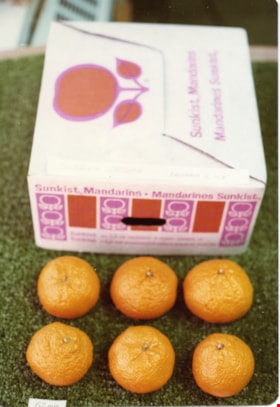
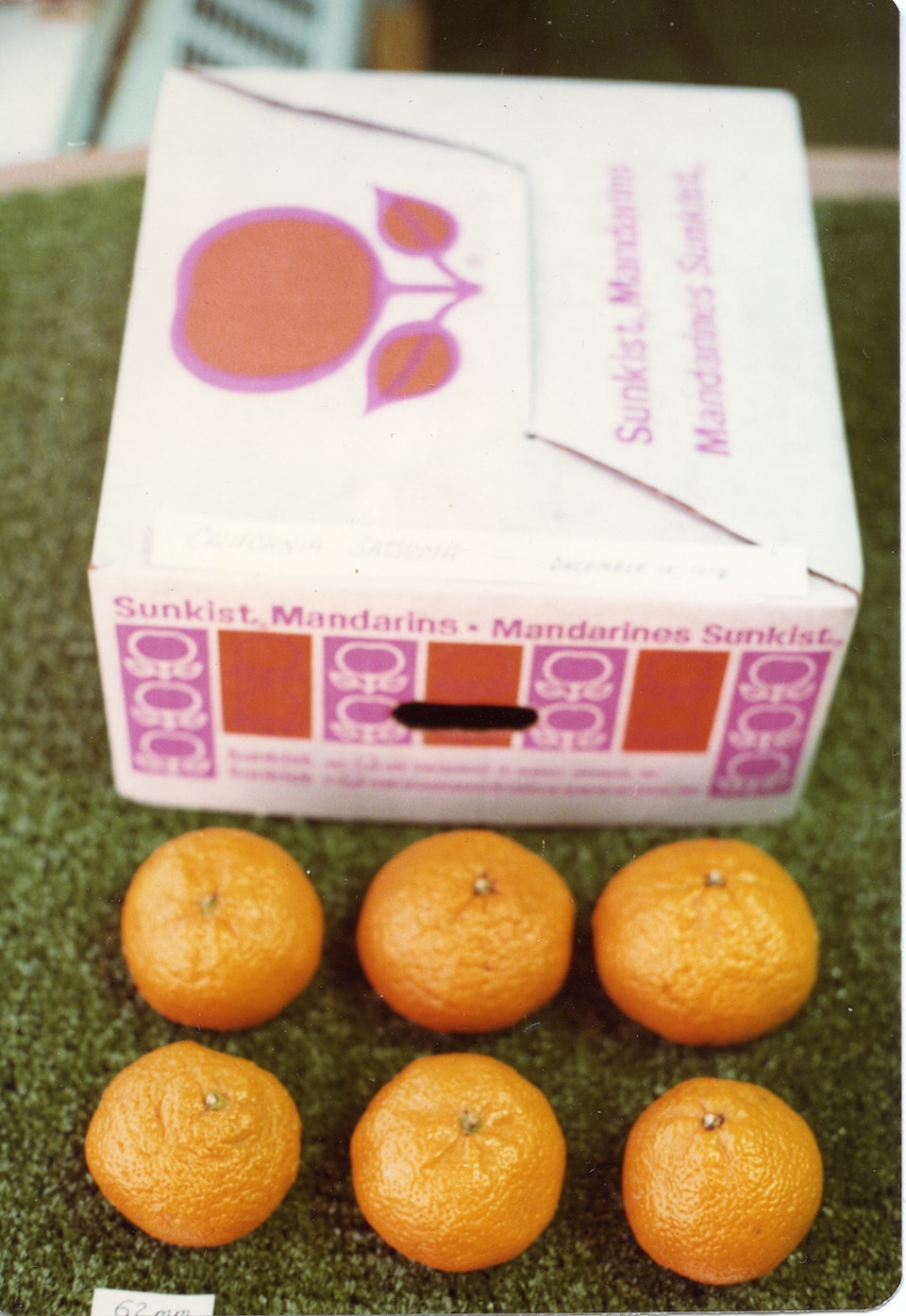
- Photograph of an arrangement of six mandarin oranges and a "Sunkist Mandarins" cardboard box with a handwritten label "California Satsuma - December 15, 1978" and a label benath "62 mm". The box and oranges are arranged in two rows of three on a surface covered with artificial turf (astroturf).
- Repository
- Burnaby Village Museum
- Collection/Fonds
- Julie Lee and Cecil Lee family fonds
- Description Level
- Item
- Physical Description
- 1 photograph : col. ; 13 x 8.7 cm
- Scope and Content
- Photograph of an arrangement of six mandarin oranges and a "Sunkist Mandarins" cardboard box with a handwritten label "California Satsuma - December 15, 1978" and a label benath "62 mm". The box and oranges are arranged in two rows of three on a surface covered with artificial turf (astroturf).
- Subjects
- Agriculture - Fruit and Berries
- Foods
- Accession Code
- BV019.6.71
- Access Restriction
- No restrictions
- Reproduction Restriction
- May be restricted by third party rights
- Date
- 15 Dec. 1978
- Media Type
- Photograph
- Scan Resolution
- 600
- Scan Date
- 20-Jan-2021
- Scale
- 100
- Notes
- Title based on contents of photograph
- Item is part of a scrapbook album created by Cecil Lee
Images

Canada Way
https://search.heritageburnaby.ca/link/archivedescription79957
- Repository
- City of Burnaby Archives
- Date
- September, 1976
- Collection/Fonds
- Burnaby Public Library Contemporary Visual Archive Project
- Description Level
- Item
- Physical Description
- 1 photograph : b&w ; 11 x 16 cm mounted on cardboard
- Scope and Content
- Photograph shows a view looking west along Canada Way, taken from Westminster Avenue.
- Repository
- City of Burnaby Archives
- Date
- September, 1976
- Collection/Fonds
- Burnaby Public Library Contemporary Visual Archive Project
- Physical Description
- 1 photograph : b&w ; 11 x 16 cm mounted on cardboard
- Description Level
- Item
- Record No.
- 556-522
- Access Restriction
- No restrictions
- Reproduction Restriction
- Reproduce for fair dealing purposes only
- Accession Number
- 2013-13
- Scope and Content
- Photograph shows a view looking west along Canada Way, taken from Westminster Avenue.
- Subjects
- Aerial Photographs
- Media Type
- Photograph
- Photographer
- Campbell, Peg
- Notes
- Scope note taken directly from BPL photograph description.
- 1 b&w copy negative : 10 x 12.5 cm accompanying
- Geographic Access
- Canada Way
- Westminster Avenue
- Planning Study Area
- Douglas-Gilpin Area
Images

![Cariboo Cloverleaf, Government Road and Gaglardi Way, [1978] thumbnail](/media/hpo/_Data/_Archives_Images/_Unrestricted/480/480-274.jpg?width=280)
Cariboo Cloverleaf, Government Road and Gaglardi Way
https://search.heritageburnaby.ca/link/archivedescription45379
- Repository
- City of Burnaby Archives
- Date
- [1978]
- Collection/Fonds
- Columbian Newspaper collection
- Description Level
- Item
- Physical Description
- 1 photograph : b&w ; 22.5 x 19 cm
- Scope and Content
- Aerial photograph of the Cariboo Cloverleaf, and the Government Road overpass construction that would join it with Gaglardi Way.
- Repository
- City of Burnaby Archives
- Date
- [1978]
- Collection/Fonds
- Columbian Newspaper collection
- Physical Description
- 1 photograph : b&w ; 22.5 x 19 cm
- Description Level
- Item
- Record No.
- 480-274
- Access Restriction
- No restrictions
- Reproduction Restriction
- No restrictions
- Accession Number
- 2003-02
- Scope and Content
- Aerial photograph of the Cariboo Cloverleaf, and the Government Road overpass construction that would join it with Gaglardi Way.
- Media Type
- Photograph
- Photographer
- King, Basil
- Notes
- Title based on contents of photograph
- Note on recto of photograph reads: "Cariboo cloverleaf in foreground and Government Road overpass construction (centre) will join with Gaglardi Way (top of pic)."
- Geographic Access
- Government Road
- Cariboo Road
- Gaglardi Way
- Historic Neighbourhood
- Burquitlam (Historic Neighbourhood)
- Planning Study Area
- Burnaby Lake Area
- Cariboo-Armstrong Area
- Cameron Area
Images
![Cariboo Cloverleaf, Government Road and Gaglardi Way, [1978] thumbnail](/media/hpo/_Data/_Archives_Images/_Unrestricted/480/480-274.jpg)
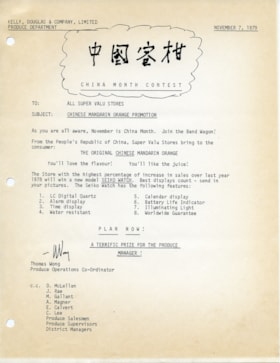
China Month Contest
https://search.heritageburnaby.ca/link/museumdescription14875
- Repository
- Burnaby Village Museum
- Date
- 7 Nov. 1979
- Collection/Fonds
- Julie Lee and Cecil Lee family fonds
- Description Level
- Item
- Physical Description
- 1 p.
- Scope and Content
- Item consists of a one page flyer from Kelly Douglas and Company Limited titled "China Month Contest (includes handwritten Chinese characters above the english title) to "All Super Valu Stores" with the subject: "Chinese Mandarin Oranges Promotion".
- Repository
- Burnaby Village Museum
- Collection/Fonds
- Julie Lee and Cecil Lee family fonds
- Description Level
- Item
- Physical Description
- 1 p.
- Scope and Content
- Item consists of a one page flyer from Kelly Douglas and Company Limited titled "China Month Contest (includes handwritten Chinese characters above the english title) to "All Super Valu Stores" with the subject: "Chinese Mandarin Oranges Promotion".
- Subjects
- Agriculture - Fruit and Berries
- Foods
- Documentary Artifacts - Leaflets
- Buildings - Commercial - Grocery Stores
- Accession Code
- BV019.6.104
- Access Restriction
- No restrictions
- Reproduction Restriction
- May be restricted by third party rights
- Date
- 7 Nov. 1979
- Media Type
- Textual Record
- Scan Resolution
- 600
- Scan Date
- 3-Nov-2020
- Scale
- 100
- Notes
- Title based on content of item
- Item is part of a scrapbook album created by Cecil Lee
Images


Construction on Acorn Avenue
https://search.heritageburnaby.ca/link/archivedescription79040
- Repository
- City of Burnaby Archives
- Date
- October 20, 1976
- Collection/Fonds
- Burnaby Public Library Contemporary Visual Archive Project
- Description Level
- Item
- Physical Description
- 1 photograph : b&w ; 11 x 16 cm mounted on cardboard
- Scope and Content
- Photograph shows a view from Hall Towers of houses and a high-rise under construction on Acorn Avenue.
- Repository
- City of Burnaby Archives
- Date
- October 20, 1976
- Collection/Fonds
- Burnaby Public Library Contemporary Visual Archive Project
- Physical Description
- 1 photograph : b&w ; 11 x 16 cm mounted on cardboard
- Description Level
- Item
- Record No.
- 556-108
- Access Restriction
- No restrictions
- Reproduction Restriction
- Reproduce for fair dealing purposes only
- Accession Number
- 2013-13
- Scope and Content
- Photograph shows a view from Hall Towers of houses and a high-rise under construction on Acorn Avenue.
- Media Type
- Photograph
- Photographer
- Ross, Martha
- Notes
- Scope note taken directly from BPL photograph description.
- 1 b&w copy negative : 10 x 12.5 cm accompanying
- Geographic Access
- Acorn Avenue
- Historic Neighbourhood
- Edmonds (Historic Neighbourhood)
- Planning Study Area
- Stride Avenue Area
Images


Corner of McGill and Gilmore
https://search.heritageburnaby.ca/link/archivedescription78894
- Repository
- City of Burnaby Archives
- Date
- September 5, 1976
- Collection/Fonds
- Burnaby Public Library Contemporary Visual Archive Project
- Description Level
- Item
- Physical Description
- 1 photograph : b&w ; 11 x 16 cm mounted on cardboard
- Scope and Content
- Photograph shows view of houses and the North Shore from the corner of McGill Street and Gilmore Avenue.
- Repository
- City of Burnaby Archives
- Date
- September 5, 1976
- Collection/Fonds
- Burnaby Public Library Contemporary Visual Archive Project
- Physical Description
- 1 photograph : b&w ; 11 x 16 cm mounted on cardboard
- Description Level
- Item
- Record No.
- 556-019
- Access Restriction
- No restrictions
- Reproduction Restriction
- Reproduce for fair dealing purposes only
- Accession Number
- 2013-13
- Scope and Content
- Photograph shows view of houses and the North Shore from the corner of McGill Street and Gilmore Avenue.
- Subjects
- Aerial Photographs
- Media Type
- Photograph
- Notes
- Scope note taken directly from BPL photograph description.
- 1 b&w copy negative : 10 x 12.5 cm accompanying
- Photographers identified by surnames only: Carr and Vardeman
- Geographic Access
- McGill Street
- Gilmore Avenue
- Historic Neighbourhood
- Vancouver Heights (Historic Neighbourhood)
- Planning Study Area
- Burnaby Heights Area
Images
