Narrow Results By
Format
- Architectural Drawing 17
- Book 135
- Bylaws - Adopted 1186
- Bylaws - Repealed 158
- Cartographic Material 16
- Council - Committee Report 1452
- Council - Manager's Report 6393
- Council - Mayor/Councillor/Staff Report 230
- Council - Public Hearing Minutes 61
- Council - Regular Council Minutes 524
- Graphic Material 12
- Landmark Description
Decade
- 2020s 56
- 2010s 49
- 2000s 60
- 1990s 88
- 1980s 69
- 1970s 83
- 1960s
- 1950s 131
- 1940s 65
- 1930s 84
- 1920s 85
- 1910s 102
- 1900s 45
- 1890s 18
- 1880s 3
- 1870s 1
- 1860s 4
- 1850s 2
- 1840s 1
- 1830s 1
- 1820s 1
- 1810s 1
- 1800s 1
- 1790s 1
- 1780s 1
- 1770s 1
- 1760s 1
- 1750s 1
- 1740s 1
- 1730s 1
- 1720s 1
- 1710s 1
- 1700s 1
- 1690s 1
- 1680s 1
- 1670s 1
- 1660s 1
- 1650s 1
- 1640s 1
- 1630s 1
- 1620s 1
- 1610s 1
- 1600s 1
Subject
- Advertising Medium - Signs and Signboards 1
- Animals 1
- Animals - Birds 1
- Animals - Cows 1
- Animals - Dogs 3
- Animals - Goats 1
- Building Components 1
- Buildings - Commercial - Malls 1
- Buildings - Commercial - Restaurants 1
- Buildings - Commercial - Stores 1
- Buildings - Heritage 1
- Buildings - Recreational - Bowling Alleys 2
Andy Digney Film
https://search.heritageburnaby.ca/link/archivedescription85335
- Repository
- City of Burnaby Archives
- Date
- [between 1934 and 1961]
- Collection/Fonds
- Digney Family fonds
- Description Level
- Item
- Physical Description
- 2 optical discs (approx. 2 hrs, 40 min) : digital, b&w, col., si.
- Scope and Content
- Item is a collection of 18 short films on DVD. These films were created by Andy Digney using his 8 mm camera and provide views of the Digney family gatherings, trips, vacations at home and abroad. They also provide glimpses of Burnaby parades, celebrations and the Digney Speedway. The 18 segments h…
- Repository
- City of Burnaby Archives
- Date
- [between 1934 and 1961]
- Collection/Fonds
- Digney Family fonds
- Physical Description
- 2 optical discs (approx. 2 hrs, 40 min) : digital, b&w, col., si.
- Description Level
- Item
- Record No.
- 562-003
- Access Restriction
- No restrictions
- Reproduction Restriction
- May be restricted by third party rights
- Accession Number
- 2014-04
- Scope and Content
- Item is a collection of 18 short films on DVD. These films were created by Andy Digney using his 8 mm camera and provide views of the Digney family gatherings, trips, vacations at home and abroad. They also provide glimpses of Burnaby parades, celebrations and the Digney Speedway. The 18 segments have all been described at item level.
- Subjects
- Animals - Dogs
- Recreational Activities - Fishing
- Recreational Activities - Camping
- Recreational Activities - Picnics
- Geographic Features - Rivers
- Events - Parades
- Media Type
- Moving Images
- Photographer
- Digney, Andy
- Creator
- Digney, Andy
- Notes
- Title based on contents of film
- The original 8mm film footage was digitized and broken down into 18 segments, reflecting the original order. Items are described as 562-003-1 : 562-003-18

Ardingley-Sprott Neighbourhood
https://search.heritageburnaby.ca/link/landmark797
- Repository
- Burnaby Heritage Planning
- Associated Dates
- 1955-2008
- Heritage Value
- The Ardingley-Sprott Neighbourhood is primarily non-residential and developed in the 1970s west of the Burnaby Lake park area. It grew to include a large recreational component in the form of the Burnaby Lake Sports Complex and playing fields.
- Historic Neighbourhood
- Burnaby Lake (Historic Neighbourhood)
- Planning Study Area
- Ardingley-Sprott Area
Images


Arrow Neon Sign
https://search.heritageburnaby.ca/link/landmark861
- Repository
- Burnaby Heritage Planning
- Description
- Commercial building.
- Associated Dates
- 1961
- Other Names
- Lost in the 50's Drive-in
- Street View URL
- Google Maps Street View
- Repository
- Burnaby Heritage Planning
- Other Names
- Lost in the 50's Drive-in
- Geographic Access
- Edmonds Street
- Associated Dates
- 1961
- Description
- Commercial building.
- Heritage Value
- The Arrow Neon Sign was built in 1961 by the Neonette Sign Company of New Westminster when this property was opened as the Tomahawk Drive-in Restaurant. The restaurant was later known as Lindy's Burger and in 1990, the business was renamed Lost in the 50's Drive-in. It stands 20-foot tall and is composed of a large double-sided hollow steel panel serpentine arrow mounted on a pole supporting a lexan sign panel measuring approximately 8 feet wide by 4 feet tall. The sign was designed with three illuminated features: a round lamp at the top of the pole, a double-sided rectangular fluorescent sign panel box, and two double-sided rows of orange neon arrows that follow the large serpentine arrow. The Arrow Neon Sign remains as a rare surviving example of neon sign art in the city and is the only historic neon sign in South Burnaby. The sign has gained prominence over the years as it has been associated with this small iconic drive-in which has also been utilized as a set for film production. Additionally, the drive-in has played a prominent role in the Edmonds community as a popular setting for recent "Show and Shine" participants to park their classic cars.
- Locality
- Edmonds
- Historic Neighbourhood
- East Burnaby (Historic Neighbourhood)
- Planning Study Area
- Lakeview-Mayfield Area
- Builder
- Neonette Sign Company
- Community
- Burnaby
- Contributing Resource
- Structure
- Ownership
- Public (local)
- Street Address
- 7741 Edmonds Street
- Street View URL
- Google Maps Street View
Images

Baby Teresa
https://search.heritageburnaby.ca/link/archivedescription85421
- Repository
- City of Burnaby Archives
- Date
- 1963
- Collection/Fonds
- George H.F. McLean fonds
- Description Level
- Item
- Physical Description
- 1 digital file ( 4 min., 15 sec ) : digital , col., si.
- Scope and Content
- Item consists of one silent, colour film segment providing glimpses of baby Teresa and family members at play inside their house and outside in their yard at 4378 Halley Avenue South. Baby Teresa can be seen walking and playing with her brothers as they push her in a cardboard box and pull her in a…
- Repository
- City of Burnaby Archives
- Date
- 1963
- Collection/Fonds
- George H.F. McLean fonds
- Physical Description
- 1 digital file ( 4 min., 15 sec ) : digital , col., si.
- Description Level
- Item
- Record No.
- 567-001-6
- Access Restriction
- No restrictions
- Reproduction Restriction
- May be restricted by third party rights
- Accession Number
- 2014-03
- Scope and Content
- Item consists of one silent, colour film segment providing glimpses of baby Teresa and family members at play inside their house and outside in their yard at 4378 Halley Avenue South. Baby Teresa can be seen walking and playing with her brothers as they push her in a cardboard box and pull her in a wagon and play outside in the garden, pool and sprinkler. The film closes with her seated on a table with her mother supporting her from behind as she celebrates her first birthday with a cake.
- Media Type
- Moving Images
- Photographer
- McLean, George H.F.
- Notes
- Title based on content of film
- Films originated in an 8mm format and were digitized by George McLean before being donated to the CBA
- Street Address
- 4378 Halley Avenue
- Historic Neighbourhood
- Broadview (Historic Neighbourhood)
- Planning Study Area
- Cascade-Schou Area
Images

Video
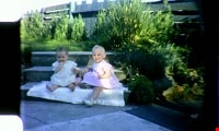
Baby Teresa, 1963
![Baby Teresa and McLean boy's birthday, [Between 1962 -1963] thumbnail](/media/Hpo/_Data/_Archives_Moving_Images/_Unrestricted/567-001-12.jpg?width=280)
Baby Teresa and McLean boy's birthday
https://search.heritageburnaby.ca/link/archivedescription85427
- Repository
- City of Burnaby Archives
- Date
- [Between 1962 -1963]
- Collection/Fonds
- George H.F. McLean fonds
- Description Level
- Item
- Physical Description
- 1 digital file ( 4 min., 18 sec ) : digital , col., si.
- Scope and Content
- Item consists of one colour film and opens with George McLean playing with his daughter Teresa, the McLean boys playing in a bedroom and brother Brad playing with Teresa while she sits in her highchair. The film continues with Teresa in a crib and being bathed in a small bathtub by her father, Geo…
- Repository
- City of Burnaby Archives
- Date
- [Between 1962 -1963]
- Collection/Fonds
- George H.F. McLean fonds
- Physical Description
- 1 digital file ( 4 min., 18 sec ) : digital , col., si.
- Description Level
- Item
- Record No.
- 567-001-12
- Access Restriction
- No restrictions
- Reproduction Restriction
- May be restricted by third party rights
- Accession Number
- 2014-03
- Scope and Content
- Item consists of one colour film and opens with George McLean playing with his daughter Teresa, the McLean boys playing in a bedroom and brother Brad playing with Teresa while she sits in her highchair. The film continues with Teresa in a crib and being bathed in a small bathtub by her father, George and closes with a McLean boy's birthday party with a Christmas tree in the background.
- Media Type
- Moving Images
- Photographer
- McLean, George H.F.
- Notes
- Title based on content of film
- Films originated in an 8mm format and were digitized by George McLean before being donated to the CBA
- Street Address
- 4378 Halley Avenue
- Historic Neighbourhood
- Broadview (Historic Neighbourhood)
- Planning Study Area
- Cascade-Schou Area
Images
![Baby Teresa and McLean boy's birthday, [Between 1962 -1963] thumbnail](/media/Hpo/_Data/_Archives_Moving_Images/_Unrestricted/567-001-12.jpg)
Video
Baby Teresa and McLean boy's birthday, [Between 1962 -1963]
Baby Teresa and McLean boy's birthday, [Between 1962 -1963]
https://search.heritageburnaby.ca/media/hpo/_Data/_Archives_Moving_Images/_Unrestricted/567-001-12.m4v
Big Bend Neighbourhood
https://search.heritageburnaby.ca/link/landmark840
- Repository
- Burnaby Heritage Planning
- Associated Dates
- 1955-2008
- Heritage Value
- The Big Bend Neighbourhood in Burnaby maintained its status as an important agricultural area in the City in the years following 1955 and it also solidified its role as a prime industrial and commercial district. In 1972, the Big Bend Development Plan was adopted by Council and soon thereafter, approximately 620 acres of land were incorporated into the Agricultural Land Reserve. These lands have been set aside for agricultural and limited recreation purposes. By the 2000s, 160 acres of land were considered highly productive agricultural areas, and over 400 acres of land had been secured as parkland, including the Fraser Foreshore Park. The area also developed large commercial and industrial districts including those at Marine Way/Boundary, the Glenlyon Estates, Riverfront Business Park, Burnaby Business Park, and Glenwood Industrial Estates.
- Historic Neighbourhood
- Fraser Arm (Historic Neighbourhood)
- Planning Study Area
- Big Bend Area
Images


Bill Copeland Sports Centre & Burnaby Lake Arena
https://search.heritageburnaby.ca/link/landmark819
- Repository
- Burnaby Heritage Planning
- Geographic Access
- Kensington Avenue
- Associated Dates
- 1965
- Heritage Value
- In February 1965, the Planning Department presented to Burnaby Council a preliminary Development Plan entitled "Pacific Sports Centre," for the area immediately west of Burnaby Lake. This report proposed a conceptual plan for a comprehensive range of indoor and outdoor sporting facilities adjacent to Burnaby Lake. The idea was accepted by Council and led to the construction of the Burnaby Lake Rink beside the C.G. Brown Pool. In 1973, Burnaby and New Westminster jointly hosted the Canada Summer Games for which a rowing course and pavilion were built at Burnaby Lake and the success of the games and the sports facilities added within Burnaby Lake Park provided further stimulus for the creation of the sports and recreation facilities at this site.
- Historic Neighbourhood
- Burnaby Lake (Historic Neighbourhood)
- Planning Study Area
- Ardingley-Sprott Area
- Street Address
- 3676 Kensington Avenue
- Street View URL
- Google Maps Street View
Images


Brantford Elementary School
https://search.heritageburnaby.ca/link/landmark809
- Repository
- Burnaby Heritage Planning
- Geographic Access
- Brantford Avenue
- Associated Dates
- 1965
- Heritage Value
- As housing developments extended north from Kingsway, pupil enrolments grew at Windsor and at Morley Schools so Brantford was built equidistant from the two to help ease enrolment problems. Brantford Elementary school opened in 1965 and was similar in structure to other schools built in Burnaby during this period - no basements, no second stories and no high stairways. Classrooms were built in a line and could easily be added to as enrolments increased. Brantford had room additions in 1969.
- Historic Neighbourhood
- Edmonds (Historic Neighbourhood)
- Planning Study Area
- Kingsway-Beresford Area
- Street Address
- 6512 Brantford Avenue
- Street View URL
- Google Maps Street View
Images


Brentwood Neighbourhood
https://search.heritageburnaby.ca/link/landmark780
- Repository
- Burnaby Heritage Planning
- Associated Dates
- 1955-2008
- Heritage Value
- Between 1955 and 2001, the Brentwood Neighbourhood developed into one of Burnaby's four official Town Centres. The Brentwood Town Centre serves the north-west sector of the Municipality, providing facilities such as commercial developments - of which the Brentwood Mall is the most significant. Under Burnaby's Residential Development Framework adopted by Council in 1981, the Town Centre also incorporated a full range of multi-housing types and forms in close relationship with their commercial facilities. In 1996, the City adopted the Brentwood Town Centre Development Plant to solidify the area as a focus of higher-density and higher-intensity residential and commercial opportunities, public transit and supporting leisure facilities.
- Planning Study Area
- Brentwood Area
Images


British Columbia Institute of Technology (BCIT)
https://search.heritageburnaby.ca/link/landmark806
- Repository
- Burnaby Heritage Planning
- Geographic Access
- Willingdon Avenue
- Associated Dates
- 1960
- Heritage Value
- The BC Vocational School was established in 1960 at Willingdon and Canada Way. By 1964, the British Columbia Insitute of Technology had opened and had 498 students enrolled. In the 1970s, the BC Vocational School had been renamed the Pacific Vocational Institute and in 1986 the two institutions merged. The school is a public post-secondary institution that is governed by a Board of Governors, under the authority of the Ministry of Advanced Education, Training and Technology. By 2004, the annual enrolment of part-time and full-time students reached 48,000.
- Planning Study Area
- Douglas-Gilpin Area
- Street Address
- 3700 Willingdon Avenue
- Street View URL
- Google Maps Street View
Images


Buckingham Elementary School
https://search.heritageburnaby.ca/link/landmark832
- Repository
- Burnaby Heritage Planning
- Geographic Access
- Buckingham Avenue
- Associated Dates
- 1962
- Heritage Value
- Buckingham Elementary School opened in 1962 with 86 pupils. The school was intended to take some of the pressure off of both Lakeview and Morley Elementary Schools which saw large volumes of enrolments throughout the 1950s. In 1964, two additional rooms were built onto the school and in 1969 a library, staffroom and medical room were added.
- Historic Neighbourhood
- Burnaby Lake (Historic Neighbourhood)
- Planning Study Area
- Morley-Buckingham Area
- Street Address
- 6066 Buckingham Avenue
- Street View URL
- Google Maps Street View
Images


Burnaby Heights Neighbourhood
https://search.heritageburnaby.ca/link/landmark776
- Repository
- Burnaby Heritage Planning
- Associated Dates
- 1955-2008
- Heritage Value
- Up until the 1970s, this neighbourhood was known as Vancouver Heights. When a new park was created during that decade and named "Burnaby Heights Park," the name was gradually adopted by newcomers to the area. Today, you will hear residents refer to their neighbourhood as Burnaby Heights, Vancouver Heights, or just "The Heights." Throughout the 1960s and 1970s, the commercial district in this neighbourhood continued to grow and a Retail Merchants Association was formed which later became known as the Heights Merchants Association. The neighbourhood still retains a residential neighbourhood characteristic with an increasing number of apartment buildings and multi-family units being built over the past 20 years.
- Historic Neighbourhood
- Vancouver Heights (Historic Neighbourhood)
- Planning Study Area
- Burnaby Heights Area
Images

Burnaby historical reference collection series
https://search.heritageburnaby.ca/link/museumdescription18928
- Repository
- Burnaby Village Museum
- Date
- 1950-1992, predominant 1950-1973
- Collection/Fonds
- Burnaby Village Museum Film and Video collection
- Description Level
- Series
- Physical Description
- 3 film reels + 20 videocassettes + 1 avi
- Scope and Content
- Series consists of a reference collection of films relating to the history of Burnaby. Films include CBUT News footage "Burnaby Mountain Sod Turning"; a documentary film "Cabin" about the building of a log cabin at Burnaby Village Museum; a documentary film "A Friend at the Door" about the work of …
- Repository
- Burnaby Village Museum
- Collection/Fonds
- Burnaby Village Museum Film and Video collection
- Description Level
- Series
- Physical Description
- 3 film reels + 20 videocassettes + 1 avi
- Scope and Content
- Series consists of a reference collection of films relating to the history of Burnaby. Films include CBUT News footage "Burnaby Mountain Sod Turning"; a documentary film "Cabin" about the building of a log cabin at Burnaby Village Museum; a documentary film "A Friend at the Door" about the work of rural social workers in British Columbia; historical film footage from B.C. Transit Centennial of the B.C. Electric Lower Mainland trams and home movie footage created by the Handel family.
- Accession Code
- HV971.30
- BV005.8
- BV005.48
- BV012.37
- BV014.39
- BV016.37
- BV017.11
- BV020.5
- Date
- 1950-1992, predominant 1950-1973
- Media Type
- Moving Images
- Notes
- Title based on contents of series
Burnaby Image Bank subseries
https://search.heritageburnaby.ca/link/archivedescription64462
- Repository
- City of Burnaby Archives
- Date
- [1910] (date of original) -1993
- Collection/Fonds
- Burnaby Historical Society fonds
- Description Level
- Subseries
- Physical Description
- Photographs and other material
- Scope and Content
- Subseries consists of the SFU/Burnaby Centennial Committee's Image Bank project records. Records include: Image Bank database and backups in a variety of formats; 813 photographs collected by Simon Fraser University Archives staff; eleven screened negatives from the Burnaby Image Bank that were us…
- Repository
- City of Burnaby Archives
- Date
- [1910] (date of original) -1993
- Collection/Fonds
- Burnaby Historical Society fonds
- Subseries
- Burnaby Image Bank subseries
- Physical Description
- Photographs and other material
- Description Level
- Subseries
- Access Restriction
- Open Access
- Accession Number
- BHS1999-03
- BHS2004-13
- BHS2001-15
- Scope and Content
- Subseries consists of the SFU/Burnaby Centennial Committee's Image Bank project records. Records include: Image Bank database and backups in a variety of formats; 813 photographs collected by Simon Fraser University Archives staff; eleven screened negatives from the Burnaby Image Bank that were used for the publication "Burnaby: A Cultural Inventory and Resource Guide"; and one VHS tape and DVD access copy of "Burnaby's Photographic Family Album / Burnaby Image Bank Collection / Volume 1 / 1992" which was created by the Committee for public viewing and purchase. The collection of photographs for the Image Bank project were gathered from various donors to commemorate the Centennial of the City of Burnaby. All photographs were collected from Burnaby families' personal albums by Simon Fraser University Archives staff during 1991 with a focus on the history of the people and the landscape of Burnaby. Photographs were collected from every decade for every neighbourhood in effort to describe the City's evolving ethnic, cultural and physical landscape. In March 1992, 20 of these images were selected by a jury for their aesthetic quality and displayed at the Bennett Library Gallery at Simon Fraser University for the "Images of Burnaby" exhibition. This exhibit travelled to various locations between 1992-1993 within Burnaby and Douglas College in New Westminster. The entire 800+ collection was made available for public purchase and viewing on video cassette. As well, each Burnaby school and each branch of the Burnaby Public Library received their own VHS copy for information and research purposes. The "Image Bank" video collection was buried alongside the video "Images and Voices of Burnaby" in the City of Burnaby's time capsule, mounted at City Hall in 1992.
- Media Type
- Photograph
- Textual Record
- Moving Images
- Creator
- SFU/Burnaby Centennial Committee
- Notes
- Title based on contents of subseries
- PC 370, MSS131, MSS088, MI577

Burnaby Lake Neighbourhood
https://search.heritageburnaby.ca/link/landmark821
- Repository
- Burnaby Heritage Planning
- Associated Dates
- 1955-2008
- Heritage Value
- In 1966 Burnaby Lake was identified as a key potential regional park in the GVRD ’s Regional Park Plan for the Lower Mainland. The lake was to be developed for nature study, strolling, trail riding, canoeing, sightseeing and picnicking. It was formally recognized as a regional nature park in 1979, at which time the GVRD assumed management of the park through a lease agreement with the City of Burnaby. In 1993 Burnaby Lake was selected by the City of Burnaby to be included in Greater Vancouver ’s Green Zone, and was identified as a key component of the GVRD ’s Park and Outdoor Recreation System (PORS) for the Burrard/Peninsula/Richmond sector, which includes Burnaby, Vancouver, New Westminster, and Richmond.
- Historic Neighbourhood
- Burnaby Lake (Historic Neighbourhood)
- Planning Study Area
- Burnaby Lake Area
Images


Burnaby Mountain Neighbourhood
https://search.heritageburnaby.ca/link/landmark792
- Repository
- Burnaby Heritage Planning
- Associated Dates
- 1955-2008
- Heritage Value
- Burnaby Mountain had been dedicated as park in 1942, however the original park boundaries were reconsidered in 1952 with the development of the Trans Mountain Pipeline. Although the boundaries were adjusted to accommodate this project, significant conservation and park lands were left untouched. When, in 1962, the government of British Columbia determined the need for additional post-secondary facilities, Burnaby Mountain was chosen as the site for the new Simon Fraser University which opened in 1965. As early as 1964, the idea of establishing a townsite around the university had been discussed by Burnaby, but it was not until the mid-1990s that the idea came to fruition and by the early 2000s, a new housing development know as the UniverCity took shape on the mountain adjacent to the university.
- Historic Neighbourhood
- Barnet (Historic Neighbourhood)
- Planning Study Area
- Burnaby Mountain Area
Images


Burnaby North High School
https://search.heritageburnaby.ca/link/landmark745
- Repository
- Burnaby Heritage Planning
- Associated Dates
- 1923-1982
- Street View URL
- Google Maps Street View
- Repository
- Burnaby Heritage Planning
- Geographic Access
- Willingdon Avenue
- Associated Dates
- 1923-1982
- Heritage Value
- Burnaby North and Burnaby South were the first high schools built in the City. Before the high school opened, Burnaby students had to travel to Vancouver if they wished to pursue education beyond an elementary level. In 1921, arrangements were made to use the basement of the Presbyterian Church for instruction of local students. By 1922 the Burnaby North High School opened at its first permanent location (4375 Pandora Street - which is now Rosser Elementary). In 1945, the Willingdon Avenue site was built and was used until a new building was constructed in 1961 on Hammarskjold Drive. From 1962, the school was used as Burnaby Heights Junior High school, but it closed in 1982 and the junior high students went to the new Burnaby North on Hammarskjold.
- Historic Neighbourhood
- Capitol Hill (Historic Neighbourhood)
- Planning Study Area
- Capitol Hill Area
- Street Address
- 250 Willingdon Avenue
- Street View URL
- Google Maps Street View
Images


Burnaby North High School
https://search.heritageburnaby.ca/link/landmark788
- Repository
- Burnaby Heritage Planning
- Geographic Access
- Hammarskjold Drive
- Associated Dates
- 1961
- Heritage Value
- In 1961, Burnaby North High School moved from Willingdon Avenue to its new site on Hammarskjold Drive. The old school remained in use as a junior high school until 1982 at which point the junior high students also moved to the new Burnaby North High School.
- Planning Study Area
- Parkcrest-Aubrey Area
- Street Address
- 751 Hammarskjold Drive
- Street View URL
- Google Maps Street View
Images


Burnaby South High School
https://search.heritageburnaby.ca/link/landmark770
- Repository
- Burnaby Heritage Planning
- Associated Dates
- 1922-1988
- Street View URL
- Google Maps Street View
- Repository
- Burnaby Heritage Planning
- Geographic Access
- Southoaks Crescent
- Associated Dates
- 1922-1988
- Heritage Value
- Burnaby South and Burnaby North were Burnaby's first high schools. The first rooms of the school were built in 1922 on the same grounds as the Kingsway East Elementary School. In 1940, a two-storey building was erected and additions were made in 1963, 1967 and 1972. Kingsway East closed in 1925 and its buildings were used by the high school for Industrial Arts and Home Economics. In the early 1990s, a new "urban education centre" (Burnaby South/B.C. School for the Deaf) was opened, replacing the old Burnaby South High School.
- Historic Neighbourhood
- Edmonds (Historic Neighbourhood)
- Planning Study Area
- Kingsway-Beresford Area
- Street Address
- 6650 Southoaks Crescent
- Street View URL
- Google Maps Street View
Images

Burnaby Village Museum Film and Video collection
https://search.heritageburnaby.ca/link/museumdescription18761
- Repository
- Burnaby Village Museum
- Date
- 1950-1992
- Collection/Fonds
- Burnaby Village Museum Film and Video collection
- Description Level
- Fonds
- Physical Description
- 3 film reels + 20 videcassettes + 1 avi video file + 17 video recordings (mp4)
- Scope and Content
- Collection consists of videos and films collected by Burnaby Village Museum from various sources. Items in this collection pertain to specific film projects about Burnaby or document people and historic events related to the history of Burnaby. Collection is arranged into the following series: 1) …
- Repository
- Burnaby Village Museum
- Collection/Fonds
- Burnaby Village Museum Film and Video collection
- Description Level
- Fonds
- Physical Description
- 3 film reels + 20 videcassettes + 1 avi video file + 17 video recordings (mp4)
- Scope and Content
- Collection consists of videos and films collected by Burnaby Village Museum from various sources. Items in this collection pertain to specific film projects about Burnaby or document people and historic events related to the history of Burnaby. Collection is arranged into the following series: 1) Burnaby historical reference collection series 2) Elders Digital Storytelling project series
- Accession Code
- HV971.30
- BV005.8
- BV005.48
- BV012.37
- BV014.39
- BV016.37
- BV017.11
- BV020.5
- Date
- 1950-1992
- Media Type
- Moving Images
- Notes
- Title based on contents of fonds
- Some items in this collection have copyright restrictions and are not available for viewing on Heritage Burnaby. Contact Burnaby Village Museum to view content.
- Further accruals expected