More like 'Intake of Burnaby's water supply'
Narrow Results By
Subject
- Accidents 2
- Accidents - Automobile Accidents 11
- Adornment 1
- Advertising Medium 12
- Advertising Medium - Signs and Signboards 56
- Aerial Photographs 42
- Agricultural Tools and Equipment 2
- Agricultural Tools and Equipment - Gardening Equipment 4
- Agricultural Tools and Equipment - Plows 5
- Agriculture 3
- Agriculture - Farms 24
- Agriculture - Fruit and Berries 2

Signage for Burnaby's COVID-19 drive thru testing site
https://search.heritageburnaby.ca/link/museumdescription15370
- Repository
- Burnaby Village Museum
- Date
- 5 Apr. 2020
- Collection/Fonds
- Burnaby Village Museum COVID-19 collection
- Description Level
- Item
- Physical Description
- 1 photograph (jpg)
- Scope and Content
- Photograph of portable LED signage at entrance to COVID-19 drive thru test site in Central Park parking lot in Burnaby. LED sign reads "Covid Care Enter Here".
- Repository
- Burnaby Village Museum
- Collection/Fonds
- Burnaby Village Museum COVID-19 collection
- Description Level
- Item
- Physical Description
- 1 photograph (jpg)
- Scope and Content
- Photograph of portable LED signage at entrance to COVID-19 drive thru test site in Central Park parking lot in Burnaby. LED sign reads "Covid Care Enter Here".
- Subjects
- Advertising Medium - Signs and Signboards
- Geographic Features - Parks
- Public Services - Health Services
- Pandemics - COVID-19
- Geographic Access
- Central Park
- Imperial Street
- Accession Code
- BV021.2.35
- Access Restriction
- No restrictions
- Reproduction Restriction
- May be restricted by third party rights
- Date
- 5 Apr. 2020
- Media Type
- Photograph
- Historic Neighbourhood
- Central Park (Historic Neighbourhood)
- Planning Study Area
- Maywood Area
- Notes
- Title based on contents of photograph
Images


Signage for Burnaby's COVID-19 drive thru testing site
https://search.heritageburnaby.ca/link/museumdescription15371
- Repository
- Burnaby Village Museum
- Date
- 5 Apr. 2020
- Collection/Fonds
- Burnaby Village Museum COVID-19 collection
- Description Level
- Item
- Physical Description
- 1 photograph (jpg)
- Scope and Content
- Photograph of portable LED signage at entrance to COVID-19 drive thru testing site in Central Park parking lot in Burnaby. LED sign reads "Mon-Fri / 12-5:45".
- Repository
- Burnaby Village Museum
- Collection/Fonds
- Burnaby Village Museum COVID-19 collection
- Description Level
- Item
- Physical Description
- 1 photograph (jpg)
- Scope and Content
- Photograph of portable LED signage at entrance to COVID-19 drive thru testing site in Central Park parking lot in Burnaby. LED sign reads "Mon-Fri / 12-5:45".
- Subjects
- Advertising Medium - Signs and Signboards
- Geographic Features - Parks
- Public Services - Health Services
- Pandemics - COVID-19
- Geographic Access
- Central Park
- Imperial Street
- Accession Code
- BV021.2.36
- Access Restriction
- No restrictions
- Reproduction Restriction
- May be restricted by third party rights
- Date
- 5 Apr. 2020
- Media Type
- Photograph
- Historic Neighbourhood
- Central Park (Historic Neighbourhood)
- Planning Study Area
- Maywood Area
- Notes
- Title based on contents of photograph
Images


Signage for Burnaby's COVID-19 drive thru testing site
https://search.heritageburnaby.ca/link/museumdescription15372
- Repository
- Burnaby Village Museum
- Date
- 5 Apr. 2020
- Collection/Fonds
- Burnaby Village Museum COVID-19 collection
- Description Level
- Item
- Physical Description
- 1 photograph (jpg)
- Scope and Content
- Photograph of portable LED signage at entrance to COVID-19 drive thru testing site in Central Park parking lot in Burnaby. LED sign reads "Burnaby Corona Virus.Com"
- Repository
- Burnaby Village Museum
- Collection/Fonds
- Burnaby Village Museum COVID-19 collection
- Description Level
- Item
- Physical Description
- 1 photograph (jpg)
- Scope and Content
- Photograph of portable LED signage at entrance to COVID-19 drive thru testing site in Central Park parking lot in Burnaby. LED sign reads "Burnaby Corona Virus.Com"
- Subjects
- Advertising Medium - Signs and Signboards
- Geographic Features - Parks
- Public Services - Health Services
- Pandemics - COVID-19
- Geographic Access
- Central Park
- Imperial Street
- Accession Code
- BV021.2.37
- Access Restriction
- No restrictions
- Reproduction Restriction
- May be restricted by third party rights
- Date
- 5 Apr. 2020
- Media Type
- Photograph
- Historic Neighbourhood
- Central Park (Historic Neighbourhood)
- Planning Study Area
- Maywood Area
- Notes
- Title based on contents of photograph
Images


Signage for Burnaby's COVID-19 drive thru testing site
https://search.heritageburnaby.ca/link/museumdescription15373
- Repository
- Burnaby Village Museum
- Date
- 5 Apr. 2020
- Collection/Fonds
- Burnaby Village Museum COVID-19 collection
- Description Level
- Item
- Physical Description
- 1 photograph (jpg)
- Scope and Content
- Photograph of portable LED signage at entrance to COVID-19 drive thru testing site in Central Park parking lot in Burnaby. LED sign reads "Sat-Sun / 12:30-5:15".
- Repository
- Burnaby Village Museum
- Collection/Fonds
- Burnaby Village Museum COVID-19 collection
- Description Level
- Item
- Physical Description
- 1 photograph (jpg)
- Scope and Content
- Photograph of portable LED signage at entrance to COVID-19 drive thru testing site in Central Park parking lot in Burnaby. LED sign reads "Sat-Sun / 12:30-5:15".
- Subjects
- Advertising Medium - Signs and Signboards
- Geographic Features - Parks
- Public Services - Health Services
- Pandemics - COVID-19
- Geographic Access
- Central Park
- Imperial Street
- Accession Code
- BV021.2.38
- Access Restriction
- No restrictions
- Reproduction Restriction
- May be restricted by third party rights
- Date
- 5 Apr. 2020
- Media Type
- Photograph
- Historic Neighbourhood
- Central Park (Historic Neighbourhood)
- Planning Study Area
- Maywood Area
- Notes
- Title based on contents of photograph
Images

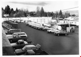
Burnaby Works Yard
https://search.heritageburnaby.ca/link/archivedescription93651
- Repository
- City of Burnaby Archives
- Date
- November 20, 1977
- Collection/Fonds
- Burnaby Public Library Contemporary Visual Archive Project
- Description Level
- Item
- Physical Description
- 1 photograph : b&w ; 12.5 x 17.5 cm
- Scope and Content
- Photograph of cars and City of Burnaby vehicles in a parking lot and the exterior of some buildings at the Laurel Street Works Yard. The photograph is taken from a high point, facing west.
- Repository
- City of Burnaby Archives
- Date
- November 20, 1977
- Collection/Fonds
- Burnaby Public Library Contemporary Visual Archive Project
- Physical Description
- 1 photograph : b&w ; 12.5 x 17.5 cm
- Description Level
- Item
- Record No.
- 556-608
- Access Restriction
- No restrictions
- Reproduction Restriction
- Reproduce for fair dealing purposes only
- Accession Number
- 2017-57
- Scope and Content
- Photograph of cars and City of Burnaby vehicles in a parking lot and the exterior of some buildings at the Laurel Street Works Yard. The photograph is taken from a high point, facing west.
- Media Type
- Photograph
- Photographer
- Surridge, Jack
- Notes
- Title taken from project information form
- Accompanied by a project information form and 1 photograph (b&w negative ; 9.5 x 12.5 cm)
- BPL no. 58
- Geographic Access
- Laurel Street
- Historic Neighbourhood
- Burnaby Lake (Historic Neighbourhood)
- Planning Study Area
- Douglas-Gilpin Area
Images
Interview with Reidun Seim by Kathy Bossort January 13, 2016 - Track 6
https://search.heritageburnaby.ca/link/oralhistory655
- Repository
- City of Burnaby Archives
- Date Range
- 1930-1950
- Length
- 0:12:19
- Summary
- This portion of the interview is about Reidun Seim talking about the end of municipal water service at Philips Avenue and the public tap available there for residents living on Burnaby Mountain. She talks about the City of Vancouver cemetery property. She describes the families and people who live…
- Repository
- City of Burnaby Archives
- Summary
- This portion of the interview is about Reidun Seim talking about the end of municipal water service at Philips Avenue and the public tap available there for residents living on Burnaby Mountain. She talks about the City of Vancouver cemetery property. She describes the families and people who lived on Burnwood (2nd Ave), and the mushroom farm that operated next door to the Seim farm.
- Date Range
- 1930-1950
- Length
- 0:12:19
- Geographic Access
- Burnaby Mountain Conservation Area
- Burnwood Avenue
- Historic Neighbourhood
- Lochdale (Historic Neighbourhood)
- Planning Study Area
- Lochdale Area
- Westridge Area
- Interviewer
- Bossort, Kathy
- Interview Date
- January 13, 2016
- Scope and Content
- Recording is of an interview with Reidun Seim conducted by Kathy Bossort. Reidun Seim was one of 23 participants interviewed as part of the Community Heritage Commission’s Burnaby Mountain Oral History Project. The interview is mainly about Reidun Seim’s memories about her parent’s farm on Curtis Street, events in her childhood, and the people who lived in or visited her neighborhood. She takes us on a tour of her neighborhood in the 1940s, telling us stories about families who lived on Curtis Street on and east of 7300 block, including people who lived on Burnaby Mountain in the old Hastings Grove subdivision above the end of municipal water service at Philips Avenue. She describes changes to Curtis Street, particularly after it provided access to Simon Fraser University in 1965. She also talks about her teaching career, and about how she values the green space and conservation area on Burnaby Mountain.
- Biographical Notes
- Reidun Seim was born in 1931 in Vancouver B.C. to Sjur and Martine Seim. Sjur and Martine Seim emigrated to Canada from Norway in 1930, and after settling in Vancouver, moved to an acre of land and a new home at the base of Burnaby Mountain in 1932. Sjur attended UBC to learn about poultry farming and began his own chicken and egg business in 1935. The farm animals and large garden also contributed to the family’s livelihood and self-sufficiency. The Curtis Street neighborhood was a lively place and extended well up Curtis Street on the west slope of Burnaby Mountain, where Reidun would babysit for families. Reidun attended Sperling Avenue Elementary School (Gr. 1-8), Burnaby North High School, and Vancouver Normal School for teacher training in 1950-1951. She began teaching primary grades in Port Coquitlam at James Park School. Most of her career was spent in North Delta, teaching at Kennedy and Annieville schools from 1954-1958, appointed Primary Consultant (1958-1960) and Primary Supervisor (1960-1985), before retiring in 1986. Reidun lived at home with her parents on Curtis Street, commuting to Delta, and continues to live in the original farmhouse.
- Total Tracks
- 14
- Total Length
- 2:35:58
- Interviewee Name
- Seim, Reidun
- Interview Location
- Burnaby City Hall in the Law Library
- Interviewer Bio
- Kathy Bossort is a retired archivist living in Ladner, BC. She worked at the Delta Museum and Archives after graduating from SLAIS (UBC) in 2001 with Masters degrees in library science and archival studies. Kathy grew up in Calgary, Alberta, and, prior to this career change, she lived in the West Kootenays, earning her living as a cook for BC tourist lodges and work camps. She continues to be interested in oral histories as a way to fill the gaps in the written record and bring richer meaning to history.
- Collection/Fonds
- Community Heritage Commission Special Projects fonds
- Media Type
- Sound Recording
Audio Tracks
Track six of interview with Reidun Seim
Track six of interview with Reidun Seim
https://search.heritageburnaby.ca/media/hpo/_Data/_Archives_Oral_Histories/_Unrestricted/MSS196-017/MSS196-017_Track_6.mp3
Opening of the Hastings-Barnet Road
https://search.heritageburnaby.ca/link/archivedescription38660
- Repository
- City of Burnaby Archives
- Date
- 1927
- Collection/Fonds
- Burnaby Historical Society fonds
- Description Level
- Item
- Physical Description
- 1 photograph : sepia ; 17.5 x 26.5 cm
- Scope and Content
- Photograph of the official opening of the newly paved Hastings-Barnet Road which opened on Saturday December 10, 1927. In the foreground the Provincial Minister of Public Works Dr. W.H. Sutherland is opening a wooden gate, with a large crowd gathered around. The Barnet Lumber Company Ltd. building …
- Repository
- City of Burnaby Archives
- Date
- 1927
- Collection/Fonds
- Burnaby Historical Society fonds
- Subseries
- North Burnaby Board of Trade subseries
- Physical Description
- 1 photograph : sepia ; 17.5 x 26.5 cm
- Description Level
- Item
- Record No.
- 476-003
- Access Restriction
- No restrictions
- Reproduction Restriction
- No known restrictions
- Accession Number
- BHS2005-8
- Scope and Content
- Photograph of the official opening of the newly paved Hastings-Barnet Road which opened on Saturday December 10, 1927. In the foreground the Provincial Minister of Public Works Dr. W.H. Sutherland is opening a wooden gate, with a large crowd gathered around. The Barnet Lumber Company Ltd. building on Hastings Street is in the background.
- Subjects
- Geographic Features - Roads
- Persons - Crowds
- Buildings - Industrial - Mills
- Officials - Elected Officials
- Public Services - Public Works
- Names
- Barnet Mill
- Sutherland, W.H.
- Media Type
- Photograph
- Notes
- Title based on contents of photograph
- Geographic Access
- Hastings Street
- Street Address
- 3995 Hastings Street
- Historic Neighbourhood
- Vancouver Heights (Historic Neighbourhood)
- Planning Study Area
- Burnaby Heights Area
Images

![Anthony Ferrari tree planting in Beecher Park, [2002] thumbnail](/media/hpo/_Data/_Archives_Images/_Unrestricted/535/535-2842.jpg?width=280)
Anthony Ferrari tree planting in Beecher Park
https://search.heritageburnaby.ca/link/archivedescription97503
- Repository
- City of Burnaby Archives
- Date
- [2002]
- Collection/Fonds
- Burnaby NewsLeader photograph collection
- Description Level
- Item
- Physical Description
- 1 photograph (tiff) : col.
- Scope and Content
- Photograph of Anthony Ferrari, an athlete with the Burnaby Winter Club AAA Bantams hockey team, planting vegetation during an environmental event with the Toronto Dominion Bank in Beecher Park.
- Repository
- City of Burnaby Archives
- Date
- [2002]
- Collection/Fonds
- Burnaby NewsLeader photograph collection
- Physical Description
- 1 photograph (tiff) : col.
- Description Level
- Item
- Record No.
- 535-2842
- Access Restriction
- No restrictions
- Reproduction Restriction
- No restrictions
- Accession Number
- 2018-12
- Scope and Content
- Photograph of Anthony Ferrari, an athlete with the Burnaby Winter Club AAA Bantams hockey team, planting vegetation during an environmental event with the Toronto Dominion Bank in Beecher Park.
- Subjects
- Persons - Athletes
- Environmental Issues
- Geographic Features - Creeks
- Geographic Features - Forests
- Names
- Burnaby Winter Club
- Media Type
- Photograph
- Photographer
- Bartel, Mario
- Notes
- Title based on caption
- Collected by editorial for use in a November 2002 issue of the Burnaby NewsLeader
- Caption from metadata: "Anthony Ferrari , a player with the Burnaby Winter Club AAA Bantams, does his part to help restore the natural habitat around Beecher Creek. Members of the team joined staff from the Toronto Dominion Bank Saturday to plant trees and native vegetation in the ongoing effort to maintain the creek as a home for fish as it passes through Beecher Park."
- Geographic Access
- Beecher Park
- Springer Avenue
- Street Address
- 1255 Springer Avenue
- Planning Study Area
- Brentwood Area
Images
![Anthony Ferrari tree planting in Beecher Park, [2002] thumbnail](/media/hpo/_Data/_Archives_Images/_Unrestricted/535/535-2842.jpg)

Boston Bar Creek on the Kettle Valley Railroad
https://search.heritageburnaby.ca/link/archivedescription34451
- Repository
- City of Burnaby Archives
- Date
- 1925
- Collection/Fonds
- Burnaby Historical Society fonds
- Description Level
- Item
- Physical Description
- 1 photograph : b&w ; 7 x 12.2 cm on page 17.5 x 26.5 cm
- Scope and Content
- Photograph of a railway bed running alongside a creek at the foot of a forested mountain. Power lines can be seen running in the foreground. The caption to the photograph reads: "Boston Bar Creek on the KVR."
- Repository
- City of Burnaby Archives
- Date
- 1925
- Collection/Fonds
- Burnaby Historical Society fonds
- Subseries
- Peers family subseries
- Physical Description
- 1 photograph : b&w ; 7 x 12.2 cm on page 17.5 x 26.5 cm
- Description Level
- Item
- Record No.
- 020-158
- Access Restriction
- No restrictions
- Reproduction Restriction
- No known restrictions
- Accession Number
- BHS2007-04
- Scope and Content
- Photograph of a railway bed running alongside a creek at the foot of a forested mountain. Power lines can be seen running in the foreground. The caption to the photograph reads: "Boston Bar Creek on the KVR."
- Media Type
- Photograph
- Notes
- Title based on caption accompanying photograph
Images


Byrne Creek
https://search.heritageburnaby.ca/link/archivedescription36107
- Repository
- City of Burnaby Archives
- Date
- February 7, 1979
- Collection/Fonds
- Burnaby Historical Society fonds
- Description Level
- Item
- Physical Description
- 1 photograph : b&w ; 15 x 19.5 cm
- Scope and Content
- Photograph of Byrne Creek at a road's edge.
- Repository
- City of Burnaby Archives
- Date
- February 7, 1979
- Collection/Fonds
- Burnaby Historical Society fonds
- Subseries
- Columbian Newspaper subseries
- Physical Description
- 1 photograph : b&w ; 15 x 19.5 cm
- Description Level
- Item
- Record No.
- 222-030
- Access Restriction
- No restrictions
- Reproduction Restriction
- Reproduce for fair dealing purposes only
- Accession Number
- BHS1989-19
- Scope and Content
- Photograph of Byrne Creek at a road's edge.
- Media Type
- Photograph
- Photographer
- King, Basil
- Notes
- Title based on contents of photograph
- Newspaper clipping glued to verso of photograph reads: "Byrne Creek...fish habitat and a problem for developers."
- Geographic Access
- Byrne Creek
- Historic Neighbourhood
- Fraser Arm (Historic Neighbourhood)
- Planning Study Area
- Big Bend Area
Images

![The Falls, Pretty's Creek, [1927] thumbnail](/media/hpo/_Data/_Archives_Images/_Unrestricted/001/020-144.jpg?width=280)
The Falls, Pretty's Creek
https://search.heritageburnaby.ca/link/archivedescription34437
- Repository
- City of Burnaby Archives
- Date
- [1927]
- Collection/Fonds
- Burnaby Historical Society fonds
- Description Level
- Item
- Physical Description
- 1 photograph : sepia ; 6.8 x 12.1 cm on page 17.5 x 26 cm
- Scope and Content
- Photograph of waterfalls identified as being located at Pretty's Creek.
- Repository
- City of Burnaby Archives
- Date
- [1927]
- Collection/Fonds
- Burnaby Historical Society fonds
- Subseries
- Peers family subseries
- Physical Description
- 1 photograph : sepia ; 6.8 x 12.1 cm on page 17.5 x 26 cm
- Description Level
- Item
- Record No.
- 020-144
- Access Restriction
- No restrictions
- Reproduction Restriction
- No known restrictions
- Accession Number
- BHS2007-04
- Scope and Content
- Photograph of waterfalls identified as being located at Pretty's Creek.
- Media Type
- Photograph
- Notes
- Title based on caption accompanying photograph
Images
![The Falls, Pretty's Creek, [1927] thumbnail](/media/hpo/_Data/_Archives_Images/_Unrestricted/001/020-144.jpg)

Haddon family
https://search.heritageburnaby.ca/link/archivedescription35568
- Repository
- City of Burnaby Archives
- Date
- 1925 (date of original), copied 1986
- Collection/Fonds
- Burnaby Historical Society fonds
- Description Level
- Item
- Physical Description
- 1 photograph : b&w ; 12.7 x 17.8 cm print
- Scope and Content
- Photograph of (left) Gordon Haddon and (right) Jimmy Haddon, his cousin, at Burnaby Lake where Eagle Creek flows into it. At the left is the dock at the foot of Piper Avenue. The water was deep and good for swimming.
- Repository
- City of Burnaby Archives
- Date
- 1925 (date of original), copied 1986
- Collection/Fonds
- Burnaby Historical Society fonds
- Subseries
- Pioneer Tales subseries
- Physical Description
- 1 photograph : b&w ; 12.7 x 17.8 cm print
- Description Level
- Item
- Record No.
- 204-426
- Access Restriction
- No restrictions
- Reproduction Restriction
- No known restrictions
- Accession Number
- BHS1988-03
- Scope and Content
- Photograph of (left) Gordon Haddon and (right) Jimmy Haddon, his cousin, at Burnaby Lake where Eagle Creek flows into it. At the left is the dock at the foot of Piper Avenue. The water was deep and good for swimming.
- Subjects
- Geographic Features - Lakes and Ponds
- Geographic Features - Creeks
- Structures - Piers and Wharves
- Sports - Swimming
- Names
- Haddon, Gordon
- Haddon, Jimmy
- Media Type
- Photograph
- Notes
- Title based on contents of photograph
- Geographic Access
- Burnaby Lake
- Piper Avenue
- Eagle Creek
- Historic Neighbourhood
- Lozells (Historic Neighbourhood)
- Planning Study Area
- Government Road Area
Images

![Ken Shymka at Still Creek, [1999] thumbnail](/media/hpo/_Data/_Archives_Images/_Unrestricted/535/535-3319-2.jpg?width=280)
Ken Shymka at Still Creek
https://search.heritageburnaby.ca/link/archivedescription98252
- Repository
- City of Burnaby Archives
- Date
- [1999]
- Collection/Fonds
- Burnaby NewsLeader photograph collection
- Description Level
- File
- Physical Description
- 2 photographs (tiff) : col.
- Scope and Content
- File contains photographs of photographer Ken Shymka posing with his camera at Still Creek.
- Repository
- City of Burnaby Archives
- Date
- [1999]
- Collection/Fonds
- Burnaby NewsLeader photograph collection
- Physical Description
- 2 photographs (tiff) : col.
- Description Level
- File
- Record No.
- 535-3319
- Access Restriction
- No restrictions
- Reproduction Restriction
- No restrictions
- Accession Number
- 2018-12
- Scope and Content
- File contains photographs of photographer Ken Shymka posing with his camera at Still Creek.
- Subjects
- Occupations - Photographers
- Geographic Features - Creeks
- Geographic Features - Streams
- Photographic Tools and Equipment - Camera
- Media Type
- Photograph
- Notes
- Title based on contents of file
- Collected by editorial for use in a September 1999 issue of the Burnaby NewsLeader
- Geographic Access
- Still Creek
Images
![Ken Shymka at Still Creek, [1999] thumbnail](/media/hpo/_Data/_Archives_Images/_Unrestricted/535/535-3319-2.jpg)
![Mark Angelo in Deer Lake Brook, [2002] thumbnail](/media/hpo/_Data/_Archives_Images/_Unrestricted/535/535-2603.jpg?width=280)
Mark Angelo in Deer Lake Brook
https://search.heritageburnaby.ca/link/archivedescription97075
- Repository
- City of Burnaby Archives
- Date
- [2002]
- Collection/Fonds
- Burnaby NewsLeader photograph collection
- Description Level
- Item
- Physical Description
- 1 photograph (tiff) : col.
- Scope and Content
- Photograph of conservationist Mark Angelo standing in Deer Lake Brook.
- Repository
- City of Burnaby Archives
- Date
- [2002]
- Collection/Fonds
- Burnaby NewsLeader photograph collection
- Physical Description
- 1 photograph (tiff) : col.
- Description Level
- Item
- Record No.
- 535-2603
- Access Restriction
- No restrictions
- Reproduction Restriction
- No restrictions
- Accession Number
- 2018-12
- Scope and Content
- Photograph of conservationist Mark Angelo standing in Deer Lake Brook.
- Subjects
- Environmental Issues - Environmental Protection
- Environmental Issues
- Geographic Features - Streams
- Geographic Features - Creeks
- Names
- Angelo, Mark
- Media Type
- Photograph
- Photographer
- Ray, Steve
- Notes
- Title based on caption
- Collected by editorial for use in a July 2002 issue of the Burnaby NewsLeader
- Caption from metadata: "Mark Angelo in Deer Lake Brook, one of the streams that may be affected by the Federal Government cuts to community stream keepers."
- Geographic Access
- Deer Lake Brook
- Historic Neighbourhood
- Burnaby Lake (Historic Neighbourhood)
- Planning Study Area
- Morley-Buckingham Area
Images
![Mark Angelo in Deer Lake Brook, [2002] thumbnail](/media/hpo/_Data/_Archives_Images/_Unrestricted/535/535-2603.jpg)
![Murky creek, [1999] thumbnail](/media/hpo/_Data/_Archives_Images/_Unrestricted/535/535-3259.jpg?width=280)
Murky creek
https://search.heritageburnaby.ca/link/archivedescription98181
- Repository
- City of Burnaby Archives
- Date
- [1999]
- Collection/Fonds
- Burnaby NewsLeader photograph collection
- Description Level
- Item
- Physical Description
- 1 photograph (tiff) : col.
- Scope and Content
- Photograph of an unidentified person squatting at the edge of a creek and putting their hand into the murky water.
- Repository
- City of Burnaby Archives
- Date
- [1999]
- Collection/Fonds
- Burnaby NewsLeader photograph collection
- Physical Description
- 1 photograph (tiff) : col.
- Description Level
- Item
- Record No.
- 535-3259
- Access Restriction
- No restrictions
- Reproduction Restriction
- No restrictions
- Accession Number
- 2018-12
- Scope and Content
- Photograph of an unidentified person squatting at the edge of a creek and putting their hand into the murky water.
- Media Type
- Photograph
- Notes
- Title based on original file name
- Collected by editorial for use in a July 1999 issue of the Burnaby NewsLeader
Images
![Murky creek, [1999] thumbnail](/media/hpo/_Data/_Archives_Images/_Unrestricted/535/535-3259.jpg)
![Still Creek conservation ceremony, [2001] thumbnail](/media/hpo/_Data/_Archives_Images/_Unrestricted/535/535-1572.jpg?width=280)
Still Creek conservation ceremony
https://search.heritageburnaby.ca/link/archivedescription95714
- Repository
- City of Burnaby Archives
- Date
- [2001]
- Collection/Fonds
- Burnaby NewsLeader photograph collection
- Description Level
- Item
- Physical Description
- 1 photograph (tiff) : col.
- Scope and Content
- Photograph of a member of the Outdoor Recreation Council of BC and Ian Waddell, Minister of the Environment, Lands and Parks, at Still Creek. They stand on a bridge over the water and are looking and gesturing toward something in the distance.
- Repository
- City of Burnaby Archives
- Date
- [2001]
- Collection/Fonds
- Burnaby NewsLeader photograph collection
- Physical Description
- 1 photograph (tiff) : col.
- Description Level
- Item
- Record No.
- 535-1572
- Access Restriction
- No restrictions
- Reproduction Restriction
- No restrictions
- Accession Number
- 2018-12
- Scope and Content
- Photograph of a member of the Outdoor Recreation Council of BC and Ian Waddell, Minister of the Environment, Lands and Parks, at Still Creek. They stand on a bridge over the water and are looking and gesturing toward something in the distance.
- Subjects
- Geographic Features - Creeks
- Geographic Features - Streams
- Officials - Elected Officials
- Events
- Names
- Still Creek
- Media Type
- Photograph
- Photographer
- Bartel, Mario
- Notes
- Title based on caption
- Collected by editorial for use in a January 2001 issue of the Burnaby NewsLeader
- Caption from metadata: "Mark Angelo, of the Outdoor Recreation Council of BC, discusses some of the enhancements that have revived Still Creek with Ian Waddell, the Minister of Environment, Lands and Parks at a ceremony to announce a new 15-30 metre wide protection area on the banks of urban streams."
- Geographic Access
- Still Creek
Images
![Still Creek conservation ceremony, [2001] thumbnail](/media/hpo/_Data/_Archives_Images/_Unrestricted/535/535-1572.jpg)
![Down Syndrome Research Foundation Resource Centre, [2001] thumbnail](/media/hpo/_Data/_Archives_Images/_Unrestricted/535/535-2211.jpg?width=280)
Down Syndrome Research Foundation Resource Centre
https://search.heritageburnaby.ca/link/archivedescription96589
- Repository
- City of Burnaby Archives
- Date
- [2001]
- Collection/Fonds
- Burnaby NewsLeader photograph collection
- Description Level
- Item
- Physical Description
- 1 photograph (tiff) : col.
- Scope and Content
- Photograph of Dana Gallagher, communications coordinator, and Josephine Mills, executive director, at the site of the under-construction Down Syndrome Research Foundation Resource Centre in North Burnaby. Mills and Gallagher hold open a plan for the Centre and a construction vehicle is visible behi…
- Repository
- City of Burnaby Archives
- Date
- [2001]
- Collection/Fonds
- Burnaby NewsLeader photograph collection
- Physical Description
- 1 photograph (tiff) : col.
- Description Level
- Item
- Record No.
- 535-2211
- Access Restriction
- No restrictions
- Reproduction Restriction
- No restrictions
- Accession Number
- 2018-12
- Scope and Content
- Photograph of Dana Gallagher, communications coordinator, and Josephine Mills, executive director, at the site of the under-construction Down Syndrome Research Foundation Resource Centre in North Burnaby. Mills and Gallagher hold open a plan for the Centre and a construction vehicle is visible behind them.
- Media Type
- Photograph
- Photographer
- Bartel, Mario
- Notes
- Title based on caption
- Collected by editorial for use in a March 2001 issue of the Burnaby NewsLeader
- Caption from metadata: "Dana Gallagher, the communications co-ordinator, and Josephine Mills, the executive director, discuss plans for the Downs Syndrome Research Centre which is about to be constructed in North Burnaby."
- Geographic Access
- Sperling Avenue
- Street Address
- 1409 Sperling Avenue
- Historic Neighbourhood
- Lochdale (Historic Neighbourhood)
- Planning Study Area
- Lochdale Area
Images
![Down Syndrome Research Foundation Resource Centre, [2001] thumbnail](/media/hpo/_Data/_Archives_Images/_Unrestricted/535/535-2211.jpg)

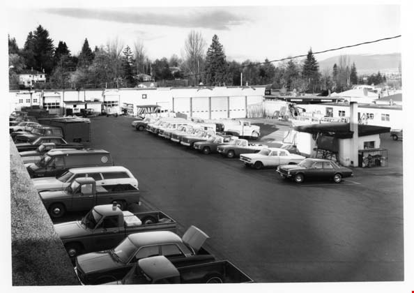
Burnaby Works Yard
https://search.heritageburnaby.ca/link/archivedescription93643
- Repository
- City of Burnaby Archives
- Date
- November 20, 1977
- Collection/Fonds
- Burnaby Public Library Contemporary Visual Archive Project
- Description Level
- Item
- Physical Description
- 1 photograph : b&w ; 12.5 x 17.5 cm
- Scope and Content
- Photograph of garbage trucks, other City vehicles, and construction equipment in a parking lot at the Laurel Street Works Yard. The photograph is taken facing north, from a high point.
- Repository
- City of Burnaby Archives
- Date
- November 20, 1977
- Collection/Fonds
- Burnaby Public Library Contemporary Visual Archive Project
- Physical Description
- 1 photograph : b&w ; 12.5 x 17.5 cm
- Description Level
- Item
- Record No.
- 556-600
- Access Restriction
- No restrictions
- Reproduction Restriction
- Reproduce for fair dealing purposes only
- Accession Number
- 2017-57
- Scope and Content
- Photograph of garbage trucks, other City vehicles, and construction equipment in a parking lot at the Laurel Street Works Yard. The photograph is taken facing north, from a high point.
- Media Type
- Photograph
- Photographer
- Chapman, Fred
- Notes
- Title taken from project information form
- Accompanied by a project information form and 1 photograph (b&w negative ; 9.5 x 12.5 cm)
- BPL no. 50
- Geographic Access
- Laurel Street
- Historic Neighbourhood
- Burnaby Lake (Historic Neighbourhood)
- Planning Study Area
- Douglas-Gilpin Area
Images

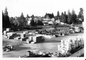
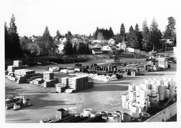
Burnaby Works Yard
https://search.heritageburnaby.ca/link/archivedescription93652
- Repository
- City of Burnaby Archives
- Date
- November 20, 1977
- Collection/Fonds
- Burnaby Public Library Contemporary Visual Archive Project
- Description Level
- Item
- Physical Description
- 1 photograph : b&w ; 12.5 x 17.5 cm
- Scope and Content
- Photograph of the Laurel Street Works Yard. The photograph is taken from a high point, facing southwest. The photograph shows pipes and other pieces of construction materials stacked on a paved area, with the residential neighbourhood visible in the background.
- Repository
- City of Burnaby Archives
- Date
- November 20, 1977
- Collection/Fonds
- Burnaby Public Library Contemporary Visual Archive Project
- Physical Description
- 1 photograph : b&w ; 12.5 x 17.5 cm
- Description Level
- Item
- Record No.
- 556-609
- Access Restriction
- No restrictions
- Reproduction Restriction
- Reproduce for fair dealing purposes only
- Accession Number
- 2017-57
- Scope and Content
- Photograph of the Laurel Street Works Yard. The photograph is taken from a high point, facing southwest. The photograph shows pipes and other pieces of construction materials stacked on a paved area, with the residential neighbourhood visible in the background.
- Media Type
- Photograph
- Photographer
- Surridge, Jack
- Notes
- Title taken from project information form
- Accompanied by a project information form and 1 photograph (b&w negative ; 9.5 x 12.5 cm)
- BPL no. 59
- Geographic Access
- Laurel Street
- Historic Neighbourhood
- Burnaby Lake (Historic Neighbourhood)
- Planning Study Area
- Douglas-Gilpin Area
Images
![Dredging equipment, [1999] thumbnail](/media/hpo/_Data/_Archives_Images/_Unrestricted/535/535-3289-1.jpg?width=280)
Dredging equipment
https://search.heritageburnaby.ca/link/archivedescription98211
- Repository
- City of Burnaby Archives
- Date
- [1999]
- Collection/Fonds
- Burnaby NewsLeader photograph collection
- Description Level
- File
- Physical Description
- 2 photographs (tiff) : col.
- Scope and Content
- File contains photographs of an unidentified worker posing on and demonstrating machinery used for dredging.
- Repository
- City of Burnaby Archives
- Date
- [1999]
- Collection/Fonds
- Burnaby NewsLeader photograph collection
- Physical Description
- 2 photographs (tiff) : col.
- Description Level
- File
- Record No.
- 535-3289
- Access Restriction
- No restrictions
- Reproduction Restriction
- No restrictions
- Accession Number
- 2018-12
- Scope and Content
- File contains photographs of an unidentified worker posing on and demonstrating machinery used for dredging.
- Media Type
- Photograph
- Notes
- Title based on original file name
- Collected by editorial for use in an August 1999 issue of the Burnaby NewsLeader
Images
![Dredging equipment, [1999] thumbnail](/media/hpo/_Data/_Archives_Images/_Unrestricted/535/535-3289-1.jpg)