More like 'Deer in the woods'
Narrow Results By
Person / Organization
- Baldwin, Ruth 1
- Barnet Mill 1
- BC Society of Model Engineers (BCSME) 1
- British Columbia Electric Railway Company 1
- Brownlee, James Harrison 1
- Burnaby Art Gallery 1
- Burnaby Lake Rowing Pavilion 1
- Burnaby Mountain Park 1
- Burnaby Village Museum 1
- Central Park 2
- Central Park Pitch 'n Putt 1
- Clinton Elementary School 1

Burnaby Lake Show / originals
https://search.heritageburnaby.ca/link/archivedescription91683
- Repository
- City of Burnaby Archives
- Date
- 1962-1995
- Collection/Fonds
- Doreen Lawson fonds
- Description Level
- File
- Physical Description
- 71 photographs : col. slides ; 35 mm
- Scope and Content
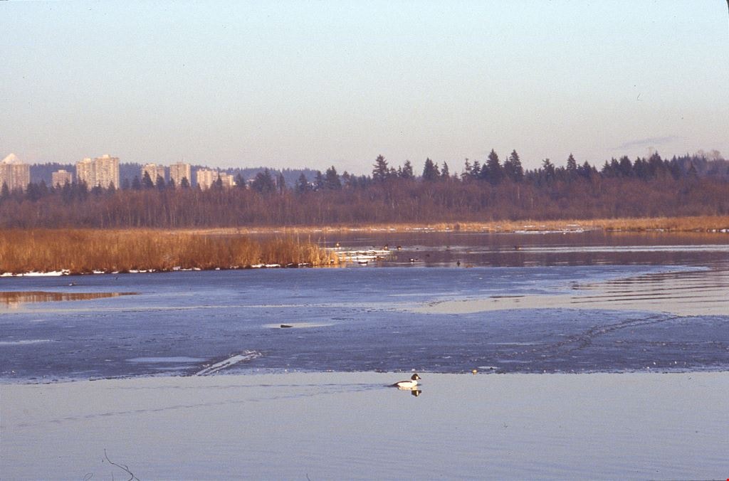
- File consists of photographs compiled by Doreen Lawson for a slideshow presentation about Burnaby Lake. Slideshow primarily depicts the wildlife and foliage of Burnaby Lake, including: the American coot, green-winged teal, bufflehead, heron, american bittern, barn swallow, barn owl, painted turtle,…
- Repository
- City of Burnaby Archives
- Date
- 1962-1995
- Collection/Fonds
- Doreen Lawson fonds
- Physical Description
- 71 photographs : col. slides ; 35 mm
- Description Level
- File
- Record No.
- 618-001
- Access Restriction
- No restrictions
- Reproduction Restriction
- May be restricted by third party rights
- Accession Number
- 2015-15
- Scope and Content
- File consists of photographs compiled by Doreen Lawson for a slideshow presentation about Burnaby Lake. Slideshow primarily depicts the wildlife and foliage of Burnaby Lake, including: the American coot, green-winged teal, bufflehead, heron, american bittern, barn swallow, barn owl, painted turtle, muskrat, Canadian goose, beaver, wood duck, bullrushes, yellow and white waterlilies, yellow iris, and loosestrife. Also included in the slideshow are photographs of the BC Wildlife rescue and fisherman working in the Brunette River.
- Subjects
- Geographic Features - Lakes and Ponds
- Animals - Birds
- Animals
- Geographic Features - Forests
- Media Type
- Photograph
- Photographer
- Lawson, Doreen A.
- Chapman, Fred
- Notes
- Transcribed title
- Title transcribed from sheets slides
- Photographs contents are identified on many of the slide cases within the file.
- Historic Neighbourhood
- Burnaby Lake (Historic Neighbourhood)
- Planning Study Area
- Burnaby Lake Area
Images


Burnaby Lake slide show
https://search.heritageburnaby.ca/link/archivedescription91684
- Repository
- City of Burnaby Archives
- Date
- 1976-1999
- Collection/Fonds
- Doreen Lawson fonds
- Description Level
- File
- Physical Description
- 85 photographs : col. slides ; 35 mm
- Scope and Content
- File consists of photographs compiled by Doreen Lawson for slideshow presentations about Burnaby Lake. Slideshow primarily depicts the wildlife and foliage of Burnaby Lake, including: the painted turtle, heron, American coot, coyote, barn owl, rainbow fry, Canadian goose, and beaver, as well as a v…
- Repository
- City of Burnaby Archives
- Date
- 1976-1999
- Collection/Fonds
- Doreen Lawson fonds
- Physical Description
- 85 photographs : col. slides ; 35 mm
- Description Level
- File
- Record No.
- 618-002
- Access Restriction
- No restrictions
- Reproduction Restriction
- May be restricted by third party rights
- Accession Number
- 2015-15
- Scope and Content
- File consists of photographs compiled by Doreen Lawson for slideshow presentations about Burnaby Lake. Slideshow primarily depicts the wildlife and foliage of Burnaby Lake, including: the painted turtle, heron, American coot, coyote, barn owl, rainbow fry, Canadian goose, and beaver, as well as a variety of scenic photographs of the Burnaby Lake shoreline with mountains and the Metrotown skyline in distance. Also included in file are photographs of people canoeing, kayaking, feeding geese, and participating in conservation activities including fencing trees and testing water levels. Photographs also depict the pipeline leading into Burnaby Lake, lake dredging equipment, and an oil slick.
- Subjects
- Geographic Features - Lakes and Ponds
- Animals - Birds
- Animals
- Geographic Features - Forests
- Media Type
- Photograph
- Photographer
- Lawson, Doreen A.
- Notes
- Title based on contents of photographs
- Note in black ink on recto of slide sheet photographs 618-002-1 : 618-002-9 originally housed in read: "Burnby Lake Slideshow"
- Note in black ink on recto of slide sheet photographs 618-002-10 : 608-002-19 originally housed in read: "Burnaby Lake / Rejects (My Fav!)"
- Photographs contents are identified on many of the slide cases within the file.
- Historic Neighbourhood
- Burnaby Lake (Historic Neighbourhood)
- Planning Study Area
- Burnaby Lake Area
Images


Burnaby Lake wildlife
https://search.heritageburnaby.ca/link/archivedescription91577
- Repository
- City of Burnaby Archives
- Date
- 1991-1997
- Collection/Fonds
- Doreen Lawson fonds
- Description Level
- File
- Physical Description
- 51 photographs : col. slides ; 35 mm
- Scope and Content
- File consists of photographs of Burnaby Lake and its wildlife. Wildlife species depicted include: heron, geese, mallards and bufflehead mallards, fuzzy green bullfrogs, a red-tailed hawk, and barn owl. Also included in the file are photographs of Cariboo Dam and purple loosestrife.
- Repository
- City of Burnaby Archives
- Date
- 1991-1997
- Collection/Fonds
- Doreen Lawson fonds
- Physical Description
- 51 photographs : col. slides ; 35 mm
- Description Level
- File
- Record No.
- 605-010
- Access Restriction
- No restrictions
- Reproduction Restriction
- No restrictions
- Accession Number
- 2003-30
- Scope and Content
- File consists of photographs of Burnaby Lake and its wildlife. Wildlife species depicted include: heron, geese, mallards and bufflehead mallards, fuzzy green bullfrogs, a red-tailed hawk, and barn owl. Also included in the file are photographs of Cariboo Dam and purple loosestrife.
- Subjects
- Geographic Features - Lakes and Ponds
- Animals - Birds
- Animals
- Geographic Features - Forests
- Names
- Lawson, Doreen A.
- Media Type
- Photograph
- Photographer
- Lawson, Doreen A.
- Notes
- Title based on contents of photographs
- Wildlife species are identified on slide cases
- Historic Neighbourhood
- Burnaby Lake (Historic Neighbourhood)
- Planning Study Area
- Burnaby Lake Area
Images

Still Creek and Burnaby Lake photographs
https://search.heritageburnaby.ca/link/archivedescription91584
- Repository
- City of Burnaby Archives
- Date
- February 3, 1998
- Collection/Fonds
- Doreen Lawson fonds
- Description Level
- File
- Physical Description
- 18 photographs : col. slides ; 35 mm
- Scope and Content
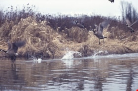
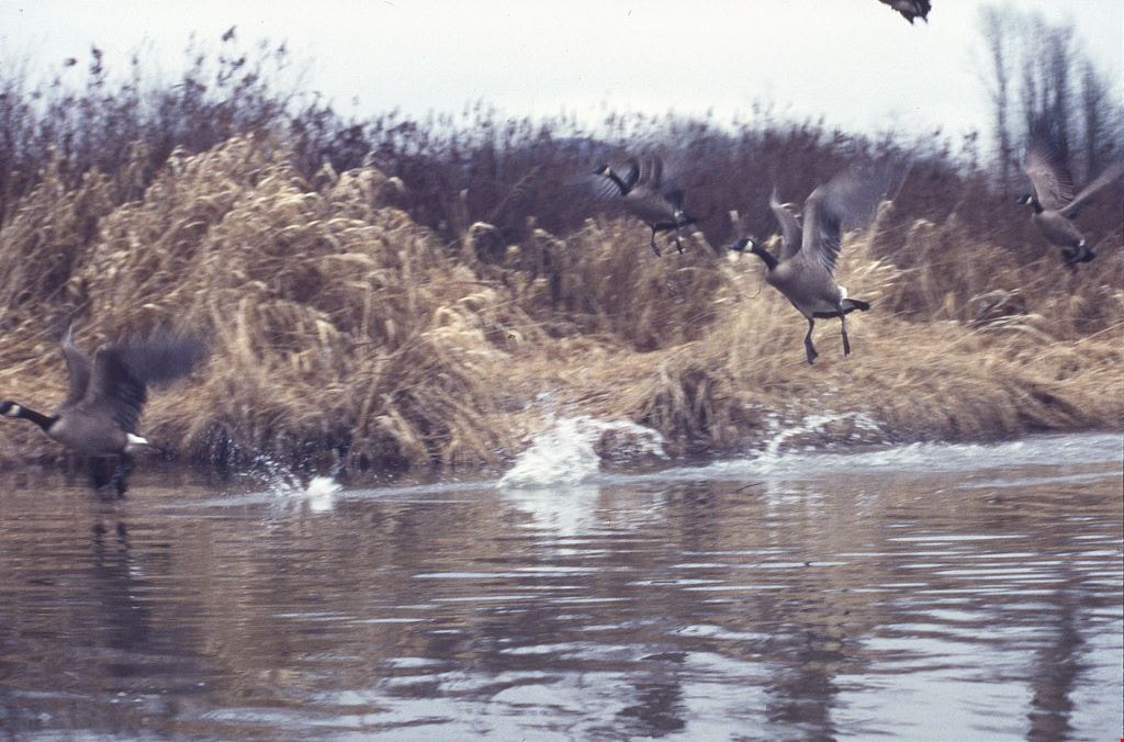
- File consists of photographs of Burnaby Lake and Still Creek, with an oil can and other debris in the water. Also included in the file are photographs of Canadian geese taking off and a man and woman kayaking on Still Creek.
- Repository
- City of Burnaby Archives
- Date
- February 3, 1998
- Collection/Fonds
- Doreen Lawson fonds
- Physical Description
- 18 photographs : col. slides ; 35 mm
- Description Level
- File
- Record No.
- 605-017
- Access Restriction
- No restrictions
- Reproduction Restriction
- No restrictions
- Accession Number
- 2003-30
- Scope and Content
- File consists of photographs of Burnaby Lake and Still Creek, with an oil can and other debris in the water. Also included in the file are photographs of Canadian geese taking off and a man and woman kayaking on Still Creek.
- Subjects
- Geographic Features - Lakes and Ponds
- Geographic Features - Forests
- Animals - Birds
- Recreational Activities
- Names
- Lawson, Doreen A.
- Media Type
- Photograph
- Photographer
- Lawson, Doreen A.
- Notes
- Title based on contents of photographs
- Geographic Access
- Burnaby Lake
- Historic Neighbourhood
- Burnaby Lake (Historic Neighbourhood)
- Planning Study Area
- Burnaby Lake Area
Images
Deer Lake wildlife
https://search.heritageburnaby.ca/link/archivedescription91578
- Repository
- City of Burnaby Archives
- Date
- January 29, 1996
- Collection/Fonds
- Doreen Lawson fonds
- Description Level
- File
- Physical Description
- 9 photographs : col. slides ; 35 mm
- Scope and Content
- File consists of photographs of a great grey owl and a murder of crows. The birds are perched in trees at Deer Lake Park. Photographs were taken in the early morning or evening.
- Repository
- City of Burnaby Archives
- Date
- January 29, 1996
- Collection/Fonds
- Doreen Lawson fonds
- Physical Description
- 9 photographs : col. slides ; 35 mm
- Description Level
- File
- Record No.
- 605-011
- Access Restriction
- No restrictions
- Reproduction Restriction
- No restrictions
- Accession Number
- 2003-30
- Scope and Content
- File consists of photographs of a great grey owl and a murder of crows. The birds are perched in trees at Deer Lake Park. Photographs were taken in the early morning or evening.
- Names
- Lawson, Doreen A.
- Media Type
- Photograph
- Photographer
- Lawson, Doreen A.
- Notes
- Title based on contents of photographs
- Note in black ink on recto of photograph 605-011-5 slide case reads: "Deer Lake / Great Grey Owl"
- Note in black ink on recto of photograph 605-011-7 slide case reads: "Crows Deer Lake"
- Geographic Access
- Deer Lake Park
- Deer Lake
- Historic Neighbourhood
- Burnaby Lake (Historic Neighbourhood)
- Planning Study Area
- Oakalla Area
Images

7837 CA Way Burnaby
https://search.heritageburnaby.ca/link/archivedescription93813
- Repository
- City of Burnaby Archives
- Date
- November 1992
- Collection/Fonds
- Grover, Elliott & Co. Ltd. fonds
- Description Level
- File
- Physical Description
- 48 photographs : col. negatives ; 35 mm + 5 photographs : col. ; 10 cm x 15 cm
- Scope and Content
- Photographs of the residential buildings located at 7837 Canada Way. Buildings include a two-storey blue-shingled house, single-storey addition, and a guest house. File also contains photographs of the Capilano suspension bridge and Capilano Suspension Bridge Park in North Vancouver.
- Repository
- City of Burnaby Archives
- Date
- November 1992
- Collection/Fonds
- Grover, Elliott & Co. Ltd. fonds
- Physical Description
- 48 photographs : col. negatives ; 35 mm + 5 photographs : col. ; 10 cm x 15 cm
- Description Level
- File
- Record No.
- 622-061
- Access Restriction
- No restrictions
- Reproduction Restriction
- No restrictions
- Accession Number
- 2017-39
- Scope and Content
- Photographs of the residential buildings located at 7837 Canada Way. Buildings include a two-storey blue-shingled house, single-storey addition, and a guest house. File also contains photographs of the Capilano suspension bridge and Capilano Suspension Bridge Park in North Vancouver.
- Media Type
- Photograph
- Notes
- Transcribed title
- Title transcribed from envelope photographs were originally housed in
- File no. 92-437-B
- Sticky note adhered to 622-061-9 print reads: "7 / View of the building looking northeast across the site".
- Sticky note adhered to 622-061-13 print reads: "6 / View of the original house and the single storey addition looking north west across the property".
- Sticky note adhered to 622-061-17 print reads: "8 / View northeast across the property from the southeast corner".
- Sticky note adhered to 622-061-21 print reads: "9 / View west from the property along the lane at the south side".
- Sticky note adhered to 622-061-26 reads: "3 / The original house now part of the guest home and the view south along the east property line".
- Sticky note adhered to 622-061-27 reads: "4 / View west along Canada Way [illegible] the subject".
- Sticky note adhered to 622-061-28 reads: "5 / The most recent addition - the single storey L shaped structure at the west end of the guesthouse".
- Sticky note adhere to 622-061-29 reads: "5A / The original house"."
- Photographer identified as "D.E."
- Geographic Access
- Canada Way
- Street Address
- 7837 Canada Way
- Planning Study Area
- Lake City Area
9886 and 9940 Broadway
https://search.heritageburnaby.ca/link/archivedescription94331
- Repository
- City of Burnaby Archives
- Date
- March 1995
- Collection/Fonds
- Grover, Elliott & Co. Ltd. fonds
- Description Level
- File
- Physical Description
- 70 photographs : col. negatives ; 35 mm
- Scope and Content
- Photographs of Broadway, various residential houses and towers, and undeveloped properties at unidentified locations.
- Repository
- City of Burnaby Archives
- Date
- March 1995
- Collection/Fonds
- Grover, Elliott & Co. Ltd. fonds
- Physical Description
- 70 photographs : col. negatives ; 35 mm
- Description Level
- File
- Record No.
- 622-116
- Access Restriction
- No restrictions
- Reproduction Restriction
- No restrictions
- Accession Number
- 2017-39
- Scope and Content
- Photographs of Broadway, various residential houses and towers, and undeveloped properties at unidentified locations.
- Media Type
- Photograph
- Notes
- Transcribed title
- Title transcribed from envelope photographs were originally housed in
- File no. 95-069-B
- Photographer identified as "K.H."
- Geographic Access
- Broadway
- Street Address
- 9886 Broadway
- 9940 Broadway
- Historic Neighbourhood
- Burquitlam (Historic Neighbourhood)
- Planning Study Area
- Lyndhurst Area

Burnaby Lake Pilot Dredging Project
https://search.heritageburnaby.ca/link/archivedescription91710
- Repository
- City of Burnaby Archives
- Date
- August 1999 - September 1999
- Collection/Fonds
- Doreen Lawson fonds
- Description Level
- File
- Physical Description
- 19 photographs : col. slides ; 35 mm
- Scope and Content
- File consists of photographs documenting the Burnaby Lake Pilot Dredging Project undertaken by the City of Burnaby between August 20 and September 16, 1999. Photographs depict silt-laded water in Still Creek prior to the dredging, mechanical dredging equipment on land and in use on the lake, and t…
- Repository
- City of Burnaby Archives
- Date
- August 1999 - September 1999
- Collection/Fonds
- Doreen Lawson fonds
- Physical Description
- 19 photographs : col. slides ; 35 mm
- Description Level
- File
- Record No.
- 618-029
- Access Restriction
- No restrictions
- Reproduction Restriction
- No restrictions
- Accession Number
- 2015-15
- Scope and Content
- File consists of photographs documenting the Burnaby Lake Pilot Dredging Project undertaken by the City of Burnaby between August 20 and September 16, 1999. Photographs depict silt-laded water in Still Creek prior to the dredging, mechanical dredging equipment on land and in use on the lake, and the adjacent water treatment facility. Also contained in the file are photographs of Deputy Director of Engineering, Lambert Chu, speaking at the dredging site and vials containing two water samples: one clear and one opaque with brown sediment.
- Media Type
- Photograph
- Photographer
- Lawson, Doreen A.
- Notes
- Title based on contents of photographs
- Geographic Access
- Burnaby Lake
- Still Creek
- Historic Neighbourhood
- Burnaby Lake (Historic Neighbourhood)
- Planning Study Area
- Burnaby Lake Area
Images

Deer Lake
https://search.heritageburnaby.ca/link/archivedescription91583
- Repository
- City of Burnaby Archives
- Date
- May 10, 1997
- Collection/Fonds
- Doreen Lawson fonds
- Description Level
- File
- Physical Description
- 15 photographs : col. slides ; 35 mm
- Scope and Content
- File consists of photographs of Deer Lake. Photographs depict foliage, primarily consisting of long grasses and deciduous tress, along the lake's shore and in the forest.
- Repository
- City of Burnaby Archives
- Date
- May 10, 1997
- Collection/Fonds
- Doreen Lawson fonds
- Physical Description
- 15 photographs : col. slides ; 35 mm
- Description Level
- File
- Record No.
- 605-016
- Access Restriction
- No restrictions
- Reproduction Restriction
- No restrictions
- Accession Number
- 2003-30
- Scope and Content
- File consists of photographs of Deer Lake. Photographs depict foliage, primarily consisting of long grasses and deciduous tress, along the lake's shore and in the forest.
- Names
- Lawson, Doreen A.
- Media Type
- Photograph
- Photographer
- Lawson, Doreen A.
- Notes
- Title based on contents of photographs
- Note in black ink on recto of slide frame of photograph 605-015-3 reads: "Deer Lake"
- Note in black ink on recto of slide fram of photograph 605-015-15 reads: "Deer Lake Park Tour / with Dinty Moore"
- Geographic Access
- Deer Lake Park
- Historic Neighbourhood
- Burnaby Lake (Historic Neighbourhood)
- Planning Study Area
- Oakalla Area
Images

2761 North Rd
https://search.heritageburnaby.ca/link/archivedescription94334
- Repository
- City of Burnaby Archives
- Date
- April 1995
- Collection/Fonds
- Grover, Elliott & Co. Ltd. fonds
- Description Level
- File
- Physical Description
- 24 photographs : col. negatives ; 35 mm
- Scope and Content
- Photographs of an undeveloped property located at 2761 North Road - an address that no longer exists. Three large billboards are posted at the edge of the property, facing onto the street.
- Repository
- City of Burnaby Archives
- Date
- April 1995
- Collection/Fonds
- Grover, Elliott & Co. Ltd. fonds
- Physical Description
- 24 photographs : col. negatives ; 35 mm
- Description Level
- File
- Record No.
- 622-119
- Access Restriction
- No restrictions
- Reproduction Restriction
- No restrictions
- Accession Number
- 2017-39
- Scope and Content
- Photographs of an undeveloped property located at 2761 North Road - an address that no longer exists. Three large billboards are posted at the edge of the property, facing onto the street.
- Media Type
- Photograph
- Photographer
- Young, Richard
- Notes
- Transcribed title
- Title transcribed from envelope photographs were originally housed in
- File no. 95-167-B
- Geographic Access
- North Road
- Historic Neighbourhood
- Burquitlam (Historic Neighbourhood)
- Planning Study Area
- Lyndhurst Area
7465 Mulberry Place
https://search.heritageburnaby.ca/link/archivedescription94305
- Repository
- City of Burnaby Archives
- Date
- February 1994
- Collection/Fonds
- Grover, Elliott & Co. Ltd. fonds
- Description Level
- File
- Physical Description
- 22 photographs : col. negatives ; 35 mm
- Scope and Content
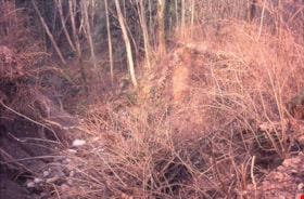
- Photographs of an undeveloped, forested property located at 7465 Mulberry Place.
- Repository
- City of Burnaby Archives
- Date
- February 1994
- Collection/Fonds
- Grover, Elliott & Co. Ltd. fonds
- Physical Description
- 22 photographs : col. negatives ; 35 mm
- Description Level
- File
- Record No.
- 622-090
- Access Restriction
- No restrictions
- Reproduction Restriction
- No restrictions
- Accession Number
- 2017-39
- Scope and Content
- Photographs of an undeveloped, forested property located at 7465 Mulberry Place.
- Subjects
- Geographic Features - Forests
- Media Type
- Photograph
- Notes
- Transcribed title
- Title transcribed from envelope photographs were originally housed in
- File no. 94-051-B
- Photographer identified as "J.C."
- Geographic Access
- Mulberry Place
- Street Address
- 7465 Mulberry Place
- Historic Neighbourhood
- East Burnaby (Historic Neighbourhood)
- Planning Study Area
- Cariboo-Armstrong Area
8678 Greenall Ave
https://search.heritageburnaby.ca/link/archivedescription94335
- Repository
- City of Burnaby Archives
- Date
- April 1995
- Collection/Fonds
- Grover, Elliott & Co. Ltd. fonds
- Description Level
- File
- Physical Description
- 25 photographs : col. negatives ; 35 mm
- Scope and Content
- Photographs of a property located at 8678 Greenal Avenue.
- Repository
- City of Burnaby Archives
- Date
- April 1995
- Collection/Fonds
- Grover, Elliott & Co. Ltd. fonds
- Physical Description
- 25 photographs : col. negatives ; 35 mm
- Description Level
- File
- Record No.
- 622-120
- Access Restriction
- No restrictions
- Reproduction Restriction
- No restrictions
- Accession Number
- 2017-39
- Scope and Content
- Photographs of a property located at 8678 Greenal Avenue.
- Subjects
- Geographic Features - Forests
- Media Type
- Photograph
- Photographer
- Young, Richard
- Notes
- Transcribed title
- Title transcribed from envelope photographs were originally housed in
- File no. 95-171-B
- Geographic Access
- Greenall Avenue
- Street Address
- 8678 Greenall Avenue
- Historic Neighbourhood
- Fraser Arm (Historic Neighbourhood)
- Planning Study Area
- Big Bend Area
![Arborists in a forest, [1999] thumbnail](/media/hpo/_Data/_Archives_Images/_Unrestricted/535/535-3236-1.jpg?width=280)
Arborists in a forest
https://search.heritageburnaby.ca/link/archivedescription98158
- Repository
- City of Burnaby Archives
- Date
- [1999]
- Collection/Fonds
- Burnaby NewsLeader photograph collection
- Description Level
- File
- Physical Description
- 7 photographs (tiff) : col.
- Scope and Content
- File contains photographs of unidentified arborists climbing and working on trees, and photographs of their climbing equipment, ropes, and saws.
- Repository
- City of Burnaby Archives
- Date
- [1999]
- Collection/Fonds
- Burnaby NewsLeader photograph collection
- Physical Description
- 7 photographs (tiff) : col.
- Description Level
- File
- Record No.
- 535-3236
- Access Restriction
- No restrictions
- Reproduction Restriction
- No restrictions
- Accession Number
- 2018-12
- Scope and Content
- File contains photographs of unidentified arborists climbing and working on trees, and photographs of their climbing equipment, ropes, and saws.
- Media Type
- Photograph
- Notes
- Title based on contents of file
- Collected by editorial for use in a June 1999 issue of the Burnaby NewsLeader
Images
![Arborists in a forest, [1999] thumbnail](/media/hpo/_Data/_Archives_Images/_Unrestricted/535/535-3236-1.jpg)
Burnaby Ambulance Station
https://search.heritageburnaby.ca/link/archivedescription94315
- Repository
- City of Burnaby Archives
- Date
- July 1994
- Collection/Fonds
- Grover, Elliott & Co. Ltd. fonds
- Description Level
- File
- Physical Description
- 45 photographs : col. negatives ; 35 mm
- Scope and Content
- Photographs of a undeveloped, forested property at unidentified location.
- Repository
- City of Burnaby Archives
- Date
- July 1994
- Collection/Fonds
- Grover, Elliott & Co. Ltd. fonds
- Physical Description
- 45 photographs : col. negatives ; 35 mm
- Description Level
- File
- Record No.
- 622-100
- Access Restriction
- No restrictions
- Reproduction Restriction
- No restrictions
- Accession Number
- 2017-39
- Scope and Content
- Photographs of a undeveloped, forested property at unidentified location.
- Subjects
- Geographic Features - Forests
- Media Type
- Photograph
- Notes
- Transcribed title
- Title transcribed from envelope photographs were originally housed in
- File no. 94-268-B
- Photographer identified as "K.H."
![Ocean View Burial Park, [1999] thumbnail](/media/hpo/_Data/_Archives_Images/_Unrestricted/535/535-3132-1.jpg?width=280)
Ocean View Burial Park
https://search.heritageburnaby.ca/link/archivedescription98052
- Repository
- City of Burnaby Archives
- Date
- [1999]
- Collection/Fonds
- Burnaby NewsLeader photograph collection
- Description Level
- File
- Physical Description
- 2 photographs (tiff) : b&w
- Scope and Content
- File contains photographs of fallen trees and debris at Ocean View Burial Park, with towers visible in the background.
- Repository
- City of Burnaby Archives
- Date
- [1999]
- Collection/Fonds
- Burnaby NewsLeader photograph collection
- Physical Description
- 2 photographs (tiff) : b&w
- Description Level
- File
- Record No.
- 535-3132
- Access Restriction
- No restrictions
- Reproduction Restriction
- No restrictions
- Accession Number
- 2018-12
- Scope and Content
- File contains photographs of fallen trees and debris at Ocean View Burial Park, with towers visible in the background.
- Names
- Ocean View Burial Park
- Media Type
- Photograph
- Notes
- Title based on original file name
- Collected by editorial for use in a March 1999 issue of the Burnaby NewsLeader
- Geographic Access
- Imperial Street
- Street Address
- 4000 Imperial Street
- Historic Neighbourhood
- Alta Vista (Historic Neighbourhood)
- Planning Study Area
- Suncrest Area
Images
![Ocean View Burial Park, [1999] thumbnail](/media/hpo/_Data/_Archives_Images/_Unrestricted/535/535-3132-1.jpg)
![Survey and Subdivision plans in New Westminster District Group 1 – Burnaby
, [1908] thumbnail](/media/hpo/_Data/_BVM_Cartographic_Material/1977/1977_0093_0004a_001.jpg?width=280)
Survey and Subdivision plans in New Westminster District Group 1 – Burnaby
https://search.heritageburnaby.ca/link/museumdescription6973
- Repository
- Burnaby Village Museum
- Date
- [1908]
- Collection/Fonds
- Burnaby Village Museum Map collection
- Description Level
- File
- Physical Description
- 10 plans : blueprint ink on paper mounted on 2 sides of cardboard ; 76 cm x 102 cm
- Scope and Content
- Item consists of a large board of four New Westminster District Gp 1 - subdivision plans mounted on one side and six New Westminster District Gp 1 - subdivision plans mounted on the other side. Side A: 1. Blueprint "Plan / of - ReSubdivision / of / Lots 1-18 inclusive / Blocks 20 and 21 / in Sub…
- Repository
- Burnaby Village Museum
- Collection/Fonds
- Burnaby Village Museum Map collection
- Description Level
- File
- Physical Description
- 10 plans : blueprint ink on paper mounted on 2 sides of cardboard ; 76 cm x 102 cm
- Material Details
- Scales [between 1:792 and 1:4752]
- Index number on edge of board reads: "4"
- Scope and Content
- Item consists of a large board of four New Westminster District Gp 1 - subdivision plans mounted on one side and six New Westminster District Gp 1 - subdivision plans mounted on the other side. Side A: 1. Blueprint "Plan / of - ReSubdivision / of / Lots 1-18 inclusive / Blocks 20 and 21 / in Subdivision / of / Lot 53 -Gr.1 / New Westminster District" / "Subdivision Lot Numbers - Shown in Red". Plan is bordered by First Street / Jorgenson's Line / Fourth Avenue and Second Street with Fifith Avenue running through the centre. There is an index in the upper right corner of the plan. Planned is signed by "Peter Byrne" and "William R. Phillips" and dated July 28, 1908. (Geographic location: Burnaby) 2. Blueprint "Plan / of Subdivision / of / Lot 159 / and a Portion of Lot 158 / Group One / New Westminster District". Plan is bordered by Lots 96 and 97; South Wilson Street; North Arm Road and Lot 160 / Power House Road (Lot 155 A). B.C.E.R. Gilley Station is identified in the upper right corner of the plan. (Geographic location: Burnaby) 3. Blueprint plan identified as "Subdvs 10, L 88 and Lot 25, G. 1" Plan identifies Cumberland Street running from top to the bottom and a Ravine running alongside with the Jensen house, stable and barn. (Geographic location: Burnaby) 4. Blueprint Plan of "Lot 153. G. 1 /New Westminster District". Plan identifies the "New Westminster & Vancouver Tramway" and the "New Westminster and Vancouver Road" running through the plan of Lot 53. (Geographic location: Burnaby) Side B: 1. Blueprint plan of "Profile on Proposed North Rd. Diversion". 2. Blueprint plan (no title) showing wood lots north of Burnaby Lake and Brunette River and west of North Road. Various lots are identified as "Heavily Timbered" (Lot 57); "Splendid Fir and Cedar / Heavy Fir etc. / Fine Cedar" (Lots 143, 148); "Rough Light Timber," (Lot 56); "Some Fir and Cedar" (Lot 40). (Geographic location: Burnaby) 3. Blueprint "Plan / of Subdivision / of a Portion / of Lot 87, Gr.1 / New Westminster District". Plan is bordered by Burnaby Lake at the top and Hastings Road / Lot 86 at the bottom and Lot 90 to the east. "Albert J. Hill B.C.LotS." Annotation in ink reads: " J.A. Brownlee, B.C.L.S. / Subdivision / Map 1494 / Bd. 248". Plan is signed by "Peter Byrne, Reeve" (Geographic location: Burnaby) 4. Blueprint plan of Subdivisions along either side of Douglas Road including Lots 117; 119; 74; 80; 79 and 77. (Geographic location: Burnaby) 5. Blueprint "Plan / of / Subdivision of / Lot 27 / in Subdivision / of / Lot 30 / Group One / New Westminster District" Plan is bordered by Lot 26, Lot 28 and Hastings Rd. Lot 27 runs north of Edmonds Street. , "Albert J. Hill, B.C.LotS." (Geographic location: Burnaby) 6. Blueprint plan identified as a "Cultivated Orchard" including the names "W. Grace" and "G. Mead" located north of the North Arm Fraser River and west of "Twentieth Street_ City Boundary". Handwritten annotation in coloured pencil reads: "Portion of Lot 172" (Geographic location: Burnaby)
- Subjects
- Geographic Features - Forests
- Geographic Access
- Cumberland Street
- North Road
- Hastings Street
- Douglas Road
- Accession Code
- HV977.93.4
- Access Restriction
- No restrictions
- Reproduction Restriction
- No known restrictions
- Date
- [1908]
- Media Type
- Cartographic Material
- Historic Neighbourhood
- Burnaby Lake (Historic Neighbourhood)
- Fraser Arm (Historic Neighbourhood)
- Planning Study Area
- Douglas-Gilpin Area
- Burnaby Lake Area
- Scan Resolution
- 300
- Scale
- 72
- Notes
- Title based on contents of file
- Scale is measured in chains. (One chain equals 792 inches)
- The term "Lot" can also refer to a "District Lot”-
Images
![Survey and Subdivision plans in New Westminster District Group 1 – Burnaby
, [1908] thumbnail](/media/hpo/_Data/_BVM_Cartographic_Material/1977/1977_0093_0004a_001.jpg)


Fish
https://search.heritageburnaby.ca/link/archivedescription91687
- Repository
- City of Burnaby Archives
- Date
- 1982-1993
- Collection/Fonds
- Doreen Lawson fonds
- Description Level
- File
- Physical Description
- 37 photographs : col. slides ; 35 mm
- Scope and Content
- File consists of photographs of the Cariboo Dam situated along the Brunette River and Warner's fish lift located adjacent to the dam. Photographs depict the interior and exterior of the fish lift, the information sign for the lift, and a group of fisherman working in the river.
- Repository
- City of Burnaby Archives
- Date
- 1982-1993
- Collection/Fonds
- Doreen Lawson fonds
- Physical Description
- 37 photographs : col. slides ; 35 mm
- Description Level
- File
- Record No.
- 618-005
- Access Restriction
- No restrictions
- Reproduction Restriction
- May be restricted by third party rights
- Accession Number
- 2015-15
- Scope and Content
- File consists of photographs of the Cariboo Dam situated along the Brunette River and Warner's fish lift located adjacent to the dam. Photographs depict the interior and exterior of the fish lift, the information sign for the lift, and a group of fisherman working in the river.
- Media Type
- Photograph
- Photographer
- Lawson, Doreen A.
- Notes
- Transcribed title
- Title transcribed from binder divider photographs were originally housed behind.
- Note in red ink on recto of slide sheet photographs 618-005-11 : 618-005-23 originally housed in read: "Burnaby Lake / Warner's Fish Lift".
- Note in black ink on recto of slide sheet photographs 618-005-24 : 618-005-37 were originally housed in read: "Brunette River Dam".
- One of the fishermen is identified as Joe Calks in photograph 618-005-4
- Geographic Access
- Brunette River
- Burnaby Lake
- Historic Neighbourhood
- Burnaby Lake (Historic Neighbourhood)
- Planning Study Area
- Burnaby Lake Area
Images


Burnaby Lake
https://search.heritageburnaby.ca/link/archivedescription91701
- Repository
- City of Burnaby Archives
- Date
- March 1982 - April 1982
- Collection/Fonds
- Doreen Lawson fonds
- Description Level
- File
- Physical Description
- 17 photographs : col. slides ; 35 mm
- Scope and Content
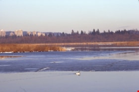
- File consists photographs of Burnaby Lake taken in late winter. The foliage around the lake is primarily brown and wilted with the first new growth of Spring just emerging. Canadian geese swim on the lake in the foreground of several of the photographs, with snow-covered mountains and the Loughee…
- Repository
- City of Burnaby Archives
- Date
- March 1982 - April 1982
- Collection/Fonds
- Doreen Lawson fonds
- Physical Description
- 17 photographs : col. slides ; 35 mm
- Description Level
- File
- Record No.
- 618-019
- Access Restriction
- No restrictions
- Reproduction Restriction
- No restrictions
- Accession Number
- 2015-15
- Scope and Content
- File consists photographs of Burnaby Lake taken in late winter. The foliage around the lake is primarily brown and wilted with the first new growth of Spring just emerging. Canadian geese swim on the lake in the foreground of several of the photographs, with snow-covered mountains and the Lougheed Mall skyline visible in the distance. Also included in the file is one photograph of the forest alongside the Brunette River.
- Media Type
- Photograph
- Photographer
- Lawson, Doreen A.
- Notes
- Transcribed title
- Title transcribed from label on slide sheets photographs originally housed in
- Geographic Access
- Burnaby Lake
- Brunette River
- Historic Neighbourhood
- Burnaby Lake (Historic Neighbourhood)
- Planning Study Area
- Burnaby Lake Area
Images

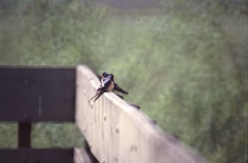
Burnaby Lake / Barn Swallows at Viewing Stands
https://search.heritageburnaby.ca/link/archivedescription91697
- Repository
- City of Burnaby Archives
- Date
- May 3, 1992
- Collection/Fonds
- Doreen Lawson fonds
- Description Level
- File
- Physical Description
- 2 photographs : col. slides ; 35 mm
- Scope and Content
- File consists of two photographs of a pair of barn swallows perched on the wooden railing of the viewing stands located at Burnaby Lake.
- Repository
- City of Burnaby Archives
- Date
- May 3, 1992
- Collection/Fonds
- Doreen Lawson fonds
- Physical Description
- 2 photographs : col. slides ; 35 mm
- Description Level
- File
- Record No.
- 618-015
- Access Restriction
- No restrictions
- Reproduction Restriction
- No restrictions
- Accession Number
- 2015-15
- Scope and Content
- File consists of two photographs of a pair of barn swallows perched on the wooden railing of the viewing stands located at Burnaby Lake.
- Media Type
- Photograph
- Photographer
- Lawson, Doreen A.
- Notes
- Transcribed title
- Title transcribed from label on slide sheet photographs originally housed in
- Geographic Access
- Burnaby Lake
- Historic Neighbourhood
- Burnaby Lake (Historic Neighbourhood)
- Planning Study Area
- Burnaby Lake Area
Images

Burnaby Lake birds
https://search.heritageburnaby.ca/link/archivedescription91685
- Repository
- City of Burnaby Archives
- Date
- 1982-1994
- Collection/Fonds
- Doreen Lawson fonds
- Description Level
- File
- Physical Description
- 54 photographs : col. slides ; 35 mm
- Scope and Content
- File consists of photographs of Burnaby Lake birds compiled by Doreen Lawson. Species depicted include: American coot, pied-billed grebe, barrows and common goldeneye, green-winged teal, wood duck, mallard duck, dowitcher, bittern moved beak, pileated woodpecker, and pigeon.
- Repository
- City of Burnaby Archives
- Date
- 1982-1994
- Collection/Fonds
- Doreen Lawson fonds
- Physical Description
- 54 photographs : col. slides ; 35 mm
- Description Level
- File
- Record No.
- 618-003
- Access Restriction
- No restrictions
- Reproduction Restriction
- May be restricted by third party rights
- Accession Number
- 2015-15
- Scope and Content
- File consists of photographs of Burnaby Lake birds compiled by Doreen Lawson. Species depicted include: American coot, pied-billed grebe, barrows and common goldeneye, green-winged teal, wood duck, mallard duck, dowitcher, bittern moved beak, pileated woodpecker, and pigeon.
- Media Type
- Photograph
- Photographer
- Lawson, Doreen A.
- Notes
- Title based on contents of photographs
- Photographs contents are identified on many of the slide cases within the file.
- Note in black ink on recto of slide sheet photographs 618-003-1 : 618-003-4 originally housed in read: "American Coots".
- Note in black ink on recto of slide sheets photographs 618-003-5 : 618-003-26 originally housed in read: "Burnaby Lake / Duck-like Birds".
- Note in black ink on recto of slide sheets photographs 618-003-27 : 618-003-31 originally housed in read: "Burnaby Lake / Duck-like Birds - Local".
- Note in black ink on recto of slide sheets photographs 618-003-43 : 618-003-51 originally housed in read: "Burnaby Lake / Shore Birds / Long Billed Dowitchers".
- Historic Neighbourhood
- Burnaby Lake (Historic Neighbourhood)
- Planning Study Area
- Burnaby Lake Area
Images