More like 'postcard'
Narrow Results By
Decade
- 2020s 96
- 2010s 43
- 2000s 492
- 1990s 423
- 1980s 423
- 1970s
- 1960s 357
- 1950s
- 1940s 495
- 1930s 396
- 1920s 442
- 1910s 489
- 1900s 210
- 1890s 39
- 1880s 64
- 1870s 5
- 1860s 3
- 1850s 3
- 1840s 1
- 1830s 2
- 1820s 1
- 1810s 1
- 1800s 1
- 1790s 1
- 1780s 1
- 1770s 1
- 1760s 1
- 1750s 1
- 1740s 1
- 1730s 1
- 1720s 1
- 1710s 1
- 1700s 1
- 1690s 1
- 1680s 1
- 1670s 1
- 1660s 1
- 1650s 1
- 1640s 1
- 1630s 1
- 1620s 1
- 1610s 1
- 1600s 1

Helen 'The Swinging Girl' Neon Sign
https://search.heritageburnaby.ca/link/landmark591
- Repository
- Burnaby Heritage Planning
- Description
- Commercial building.
- Associated Dates
- 1956
- Formal Recognition
- Heritage Designation, Community Heritage Register
- Other Names
- Helen's Childrens Wear Sign
- Street View URL
- Google Maps Street View
- Repository
- Burnaby Heritage Planning
- Other Names
- Helen's Childrens Wear Sign
- Geographic Access
- Hastings Street
- Associated Dates
- 1956
- Formal Recognition
- Heritage Designation, Community Heritage Register
- Enactment Type
- Bylaw No. 12771
- Enactment Date
- 19/04/2010
- Description
- Commercial building.
- Heritage Value
- While the building here is of some importance as the former North Burnaby municipal office, its primary importance is its delightful neon sign that has become a North Burnaby landmark. Helen Arnold opened Helen’s Childrens Wear shop in the building next door to the old Municipal offices in 1948. In 1955, when North Burnaby moved out, she moved into the vacated building. As part of the renovations, Helen enlisted the assistance of her good friend Jimmy Wallace, owner of Vancouver’s Wallace Neon Company, to create a new sign for her expanded business. One of the company’s designers, Reeve Lehman, created the swinging neon girl that was installed in 1956. Designed in two parts, one section of the sign is cloud shaped and reads ‘Helen’s’ while the other section is a moving representation of a little girl on a swing. The sign is nine feet six inches high and nine feet wide, and the lower section is animated with an internal motor and gears. It immediately became a landmark on Hastings Street, and recently the sign’s design fame has spread far and wide as one of the best surviving examples of kinetic neon art in North America.
- Locality
- Vancouver Heights
- Historic Neighbourhood
- Vancouver Heights (Historic Neighbourhood)
- Planning Study Area
- Willingdon Heights Area
- Community
- Burnaby
- Names
- Helen's Childrens Wear
- Street Address
- 4142 Hastings Street
- Street View URL
- Google Maps Street View
Images


![Haida Grill at the Astor Hotel, [between 1955 and 1959] thumbnail](/media/hpo/_Data/_Archives_Images/_Unrestricted/316/327-001.jpg?width=280)
Haida Grill at the Astor Hotel
https://search.heritageburnaby.ca/link/archivedescription37173
- Repository
- City of Burnaby Archives
- Date
- [between 1955 and 1959]
- Collection/Fonds
- Burnaby Historical Society fonds
- Description Level
- Item
- Physical Description
- 1 postcard ; col. ; 8 x 13 cm
- Scope and Content
- Postcard with a photograph of the Haida Grill at the Astor Hotel, which was known as being Burnaby's million dollar, ultra-modern hotel.
- Repository
- City of Burnaby Archives
- Date
- [between 1955 and 1959]
- Collection/Fonds
- Burnaby Historical Society fonds
- Subseries
- Lee Lightfoot subseries
- Physical Description
- 1 postcard ; col. ; 8 x 13 cm
- Description Level
- Item
- Record No.
- 327-001
- Access Restriction
- No restrictions
- Reproduction Restriction
- Reproduce for fair dealing purposes only
- Accession Number
- BHS1996-13
- Scope and Content
- Postcard with a photograph of the Haida Grill at the Astor Hotel, which was known as being Burnaby's million dollar, ultra-modern hotel.
- Subjects
- Buildings - Commercial - Hotels and Motels
- Buildings - Commercial - Restaurants
- Documentary Artifacts - Postcards
- Names
- Astor Hotel
- Media Type
- Photograph
- Notes
- Title based on contents of photograph
- Caption on recto of postcard reads: "ASTOR HOTEL . 4561 KINGSWAY, BURNABY 1, B.C."
- Caption on verso of postcard reads: "THE HAIDA GRILL/ The delightful setting and excellent cuisine makes the Haida Grill a must for dining pleasure. A Photograph [sic] showing the Haida Grill with its table side service."
- Geographic Access
- Kingsway
- Street Address
- 4561 Kingsway
- Historic Neighbourhood
- Central Park (Historic Neighbourhood)
- Planning Study Area
- Marlborough Area
Images
![Haida Grill at the Astor Hotel, [between 1955 and 1959] thumbnail](/media/hpo/_Data/_Archives_Images/_Unrestricted/316/327-001.jpg)
![The Fair Haven, [between 1950 and 1957] thumbnail](/media/Hpo/_Data/_Archives_Images/_Unrestricted/251/305-001.jpg?width=280)
The Fair Haven
https://search.heritageburnaby.ca/link/archivedescription36597
- Repository
- City of Burnaby Archives
- Date
- [between 1950 and 1957]
- Collection/Fonds
- Burnaby Historical Society fonds
- Description Level
- Item
- Physical Description
- 1 photograph : col. postcard ; 9 x 14 cm
- Scope and Content
- Aerial photographic postcard of "the Fair Haven," a group of United Church homes for Senior Citizens. The road in the foreground is Rumble Street, and the long road to the right is Sussex Avenue. The small forest behind "the Fair Haven" is the David Gary Park.
- Repository
- City of Burnaby Archives
- Date
- [between 1950 and 1957]
- Collection/Fonds
- Burnaby Historical Society fonds
- Subseries
- Vera Jackson Pel subseries
- Physical Description
- 1 photograph : col. postcard ; 9 x 14 cm
- Description Level
- Item
- Record No.
- 305-001
- Access Restriction
- No restrictions
- Reproduction Restriction
- Reproduce for fair dealing purposes only
- Accession Number
- BHS1992-46
- Scope and Content
- Aerial photographic postcard of "the Fair Haven," a group of United Church homes for Senior Citizens. The road in the foreground is Rumble Street, and the long road to the right is Sussex Avenue. The small forest behind "the Fair Haven" is the David Gary Park.
- Subjects
- Aerial Photographs
- Documentary Artifacts - Postcards
- Buildings - Residential - Seniors Housing
- Names
- Fair Haven
- Media Type
- Photograph
- Notes
- Typewritten note on verso of postcard reads: "AERIAL VIEW/ 'The Fairhaven', Burnaby BC / United Church Homes for Senior Citizens / 4341 Rumble St., Burnaby, BC"
- Handwritten note on verso of postcard reads: ""The road in the foreground is Rumble Street. The long road to the right is Sussex Avenue. The road, going up, on the left, barely visible is McKay Avenue = lower corner. Behind Fair Haven is the future David Gary Park cleared in the late 1950's - then more trees were felled in October 1962 with Hurricane Freda (blown over, uprooted trees) that left the park as it is today in 1993. The top row of little (5) white cottages were moved from the N.W. corner of Willingdon and Kingsway where Old Orchard Mall is now - they were part of Old Orchard Auto Villas, the first Fair Havens. Note: All cottages on right side of Lodge have been moved to Vancouver Island in 1991 for Motel units - by barge."
- Printed on verso of postcard: "Traveltime product, made in Vancouver, Canada, by Grant-Mann Lithographers Ltd."
- Geographic Access
- Rumble Street
- Street Address
- 4341 Rumble Street
- Historic Neighbourhood
- Alta-Vista (Historic Neighbourhood)
- Planning Study Area
- Sussex-Nelson Area
Images
![The Fair Haven, [between 1950 and 1957] thumbnail](/media/Hpo/_Data/_Archives_Images/_Unrestricted/251/305-001.jpg)
![George Derby Health Centre, [between 1950 and 1954] (date of original), copied 1991 thumbnail](/media/hpo/_Data/_Archives_Images/_Unrestricted/370/370-127.jpg?width=280)
George Derby Health Centre
https://search.heritageburnaby.ca/link/archivedescription37539
- Repository
- City of Burnaby Archives
- Date
- [between 1950 and 1954] (date of original), copied 1991
- Collection/Fonds
- Burnaby Historical Society fonds
- Description Level
- Item
- Physical Description
- 1 photograph : b&w ; 3.4 x 5.0 cm print on contact sheet 20.2 x 25.3 cm
- Scope and Content
- Aerial photograph of the George Derby Health Centre, copied from a postcard.
- Repository
- City of Burnaby Archives
- Date
- [between 1950 and 1954] (date of original), copied 1991
- Collection/Fonds
- Burnaby Historical Society fonds
- Subseries
- Burnaby Image Bank subseries
- Physical Description
- 1 photograph : b&w ; 3.4 x 5.0 cm print on contact sheet 20.2 x 25.3 cm
- Description Level
- Item
- Record No.
- 370-127
- Access Restriction
- No restrictions
- Reproduction Restriction
- No restrictions
- Accession Number
- BHS1999-03
- Scope and Content
- Aerial photograph of the George Derby Health Centre, copied from a postcard.
- Media Type
- Photograph
- Notes
- Title based on caption on photograph
- 1 b&w copy negative accompanying
- Caption on photograph reads, "George Derby Health Centre, Burnaby B.C."
- Geographic Access
- Cumberland Street
- Street Address
- 7550 Cumberland Street
- Historic Neighbourhood
- East Burnaby (Historic Neighbourhood)
- Planning Study Area
- Cariboo-Armstrong Area
Images
![George Derby Health Centre, [between 1950 and 1954] (date of original), copied 1991 thumbnail](/media/hpo/_Data/_Archives_Images/_Unrestricted/370/370-127.jpg)

Simon Fraser University
https://search.heritageburnaby.ca/link/archivedescription37404
- Repository
- City of Burnaby Archives
- Date
- 1970
- Collection/Fonds
- Burnaby Historical Society fonds
- Description Level
- Item
- Physical Description
- 1 photograph : col. postcard ; 9 x 14 cm
- Scope and Content
- Aerial photographic postcard of Simon Fraser University and Burnaby Mountain.
- Repository
- City of Burnaby Archives
- Date
- 1970
- Collection/Fonds
- Burnaby Historical Society fonds
- Subseries
- Robert Prittie subseries
- Physical Description
- 1 photograph : col. postcard ; 9 x 14 cm
- Description Level
- Item
- Record No.
- 369-003
- Access Restriction
- No restrictions
- Reproduction Restriction
- Reproduce for fair dealing purposes only
- Accession Number
- BHS1999-01
- Scope and Content
- Aerial photographic postcard of Simon Fraser University and Burnaby Mountain.
- Subjects
- Buildings - Schools - Universities and Colleges
- Aerial Photographs
- Documentary Artifacts - Postcards
- Names
- Simon Fraser University
- Media Type
- Photograph
- Photographer
- Thompson, Fred
- Notes
- Title based on contents of photograph.
- Geographic Access
- University Drive
- Street Address
- 8888 University Drive
- Planning Study Area
- Burnaby Mountain Area
Images


Simon Fraser University
https://search.heritageburnaby.ca/link/archivedescription37405
- Repository
- City of Burnaby Archives
- Date
- 1970
- Collection/Fonds
- Burnaby Historical Society fonds
- Description Level
- Item
- Physical Description
- 1 photograph : col. postcard ; 9 x 14 cm
- Scope and Content
- Aerial photographic postcard taken looking west over the parking lot and the Academic Quadrangle at Simon Fraser University.
- Repository
- City of Burnaby Archives
- Date
- 1970
- Collection/Fonds
- Burnaby Historical Society fonds
- Subseries
- Robert Prittie subseries
- Physical Description
- 1 photograph : col. postcard ; 9 x 14 cm
- Description Level
- Item
- Record No.
- 369-004
- Access Restriction
- No restrictions
- Reproduction Restriction
- Reproduce for fair dealing purposes only
- Accession Number
- BHS1999-01
- Scope and Content
- Aerial photographic postcard taken looking west over the parking lot and the Academic Quadrangle at Simon Fraser University.
- Subjects
- Aerial Photographs
- Buildings - Schools - Universities and Colleges
- Documentary Artifacts - Postcards
- Names
- Simon Fraser University
- Media Type
- Photograph
- Photographer
- Hildred, Chris
- Notes
- Title based on caption
- Geographic Access
- University Drive
- Street Address
- 8888 University Drive
- Planning Study Area
- Burnaby Mountain Area
Images


Simon Fraser University Buildings
https://search.heritageburnaby.ca/link/archivedescription37406
- Repository
- City of Burnaby Archives
- Date
- 1970
- Collection/Fonds
- Burnaby Historical Society fonds
- Description Level
- Item
- Physical Description
- 1 photograph : col. postcard ; 9 x 14 cm
- Scope and Content
- Photographic postcard taken looking north towards Simon Fraser University. The caption on the back of the postcard reads: "The aerial view shows part of the university buildings on Burnaby Mountain, with Burrard Inlet, Indian Arm and the North Shore Mountains in the background."
- Repository
- City of Burnaby Archives
- Date
- 1970
- Collection/Fonds
- Burnaby Historical Society fonds
- Subseries
- Robert Prittie subseries
- Physical Description
- 1 photograph : col. postcard ; 9 x 14 cm
- Description Level
- Item
- Record No.
- 369-005
- Access Restriction
- No restrictions
- Reproduction Restriction
- Reproduce for fair dealing purposes only
- Accession Number
- BHS1999-01
- Scope and Content
- Photographic postcard taken looking north towards Simon Fraser University. The caption on the back of the postcard reads: "The aerial view shows part of the university buildings on Burnaby Mountain, with Burrard Inlet, Indian Arm and the North Shore Mountains in the background."
- Subjects
- Aerial Photographs
- Buildings - Schools - Universities and Colleges
- Geographic Features - Mountains
- Documentary Artifacts - Postcards
- Names
- Simon Fraser University
- Media Type
- Photograph
- Notes
- Title based on caption
- Geographic Access
- University Drive
- Street Address
- 8888 University Drive
- Planning Study Area
- Burnaby Mountain Area
Images

![Blue Haven Motel, [195-] thumbnail](/media/hpo/_Data/_Archives_Images/_Unrestricted/126/199-001.jpg?width=280)
Blue Haven Motel
https://search.heritageburnaby.ca/link/archivedescription35136
- Repository
- City of Burnaby Archives
- Date
- [195-]
- Collection/Fonds
- Burnaby Historical Society fonds
- Description Level
- Item
- Physical Description
- 1 photograph : col. postcard ; 8.9 x 13.9 cm
- Scope and Content
- Photographic postcard of the Blue Haven Motel, 7026 Kingsway. The description printed on the back of the postcard reads, "Blue Haven Motel / 7026 Kingsway, South Burnaby, B.C., Canada / Mrgs.: Mr. and Mrs. A. Pearson / 22 Units - 4 Stars - AAA - ACRA / T.V. Equipped / Telephone LA 1-9942." The bui…
- Repository
- City of Burnaby Archives
- Date
- [195-]
- Collection/Fonds
- Burnaby Historical Society fonds
- Subseries
- Photographs subseries
- Physical Description
- 1 photograph : col. postcard ; 8.9 x 13.9 cm
- Description Level
- Item
- Record No.
- 199-001
- Access Restriction
- No restrictions
- Reproduction Restriction
- Reproduce for fair dealing purposes only
- Accession Number
- BHS1987-10
- Scope and Content
- Photographic postcard of the Blue Haven Motel, 7026 Kingsway. The description printed on the back of the postcard reads, "Blue Haven Motel / 7026 Kingsway, South Burnaby, B.C., Canada / Mrgs.: Mr. and Mrs. A. Pearson / 22 Units - 4 Stars - AAA - ACRA / T.V. Equipped / Telephone LA 1-9942." The building on the left side of the photograph has "Office" written on the door. Cars and motel units are seen at the right.
- Names
- Blue Haven Motel
- Media Type
- Photograph
- Responsibility
- Printed on back of postcard: "Traveltime product. Made in Vancouver, Canada, by Grant-Mann Lithographers, Ltd."
- Notes
- Title based on contents of photograph
- Geographic Access
- Kingsway
- Street Address
- 7026 Kingsway
- Historic Neighbourhood
- Edmonds (Historic Neighbourhood)
- Planning Study Area
- Stride Avenue Area
Images
![Blue Haven Motel, [195-] thumbnail](/media/hpo/_Data/_Archives_Images/_Unrestricted/126/199-001.jpg)
![Hotel Burnaby, [1953] thumbnail](/media/hpo/_Data/_Archives_Images/_Unrestricted/371/410-001.jpg?width=280)
Hotel Burnaby
https://search.heritageburnaby.ca/link/archivedescription38341
- Repository
- City of Burnaby Archives
- Date
- [1953]
- Collection/Fonds
- Burnaby Historical Society fonds
- Description Level
- Item
- Physical Description
- 1 photograph : b&w postcard ; 8.7 x 13.1 cm
- Scope and Content
- Photographic postcard advertising the Hotel Burnaby at 1385 Kingsway (old street numbering). A caption on the reverse of the postcard reads: Hotel Burnaby / :Located between new Simpsons-Sears and new Woodwards shopping centres / You will remember Hotel Burnaby for the REST of your life."
- Repository
- City of Burnaby Archives
- Date
- [1953]
- Collection/Fonds
- Burnaby Historical Society fonds
- Subseries
- Jim Wolf subseries
- Physical Description
- 1 photograph : b&w postcard ; 8.7 x 13.1 cm
- Description Level
- Item
- Record No.
- 410-001
- Access Restriction
- No restrictions
- Reproduction Restriction
- Reproduce for fair dealing purposes only
- Accession Number
- BHS2000-11
- Scope and Content
- Photographic postcard advertising the Hotel Burnaby at 1385 Kingsway (old street numbering). A caption on the reverse of the postcard reads: Hotel Burnaby / :Located between new Simpsons-Sears and new Woodwards shopping centres / You will remember Hotel Burnaby for the REST of your life."
- Subjects
- Advertising Medium
- Documentary Artifacts - Postcards
- Buildings - Commercial - Hotels and Motels
- Names
- Hotel Burnaby Limited
- Media Type
- Photograph
- Notes
- Title based on contents of photograph
- Geographic Access
- Kingsway
- Historic Neighbourhood
- Edmonds (Historic Neighbourhood)
- Planning Study Area
- Stride Avenue Area
Images
![Hotel Burnaby, [1953] thumbnail](/media/hpo/_Data/_Archives_Images/_Unrestricted/371/410-001.jpg)
![Hotel Burnaby Ltd., [1955] thumbnail](/media/hpo/_Data/_Archives_Images/_Unrestricted/371/474-001.jpg?width=280)
Hotel Burnaby Ltd.
https://search.heritageburnaby.ca/link/archivedescription38656
- Repository
- City of Burnaby Archives
- Date
- [1955]
- Collection/Fonds
- Burnaby Historical Society fonds
- Description Level
- Item
- Physical Description
- 1 photograph : col. postcard ; 9 x 14 cm
- Scope and Content
- Photographic postcard of Burnaby Hotel located at 1385 Kingsway (old street numbering system). Printed at the bottom of the postcard is the following: Hotel Burnaby Ltd. / 1385 Kingsway at 14th Avenue / Burnaby 3, New Westminster, B.C., Telephone LA 1-8891. On the reverse is written: "Hotel Burna…
- Repository
- City of Burnaby Archives
- Date
- [1955]
- Collection/Fonds
- Burnaby Historical Society fonds
- Subseries
- Jim Wolf subseries
- Physical Description
- 1 photograph : col. postcard ; 9 x 14 cm
- Description Level
- Item
- Record No.
- 474-001
- Access Restriction
- No restrictions
- Reproduction Restriction
- Reproduce for fair dealing purposes only
- Accession Number
- BHS2005-6
- Scope and Content
- Photographic postcard of Burnaby Hotel located at 1385 Kingsway (old street numbering system). Printed at the bottom of the postcard is the following: Hotel Burnaby Ltd. / 1385 Kingsway at 14th Avenue / Burnaby 3, New Westminster, B.C., Telephone LA 1-8891. On the reverse is written: "Hotel Burnaby: Located between new Simpson-Sears and new Woodwards shopping centres. You will remember Hotel Burnaby for the rest of your life."
- Subjects
- Buildings - Commercial - Hotels and Motels
- Documentary Artifacts - Postcards
- Advertising Medium
- Names
- Hotel Burnaby Limited
- Media Type
- Photograph
- Photographer
- Grant-Mann Lithographers Limited
- Notes
- Title based on caption of postcard
- Made by Grant-Mann Lithographers Ltd. "Colour Card" Division, Vancouver British Columbia
- Geographic Access
- Kingsway
- Historic Neighbourhood
- Edmonds (Historic Neighbourhood)
- Planning Study Area
- Stride Avenue Area
Images
![Hotel Burnaby Ltd., [1955] thumbnail](/media/hpo/_Data/_Archives_Images/_Unrestricted/371/474-001.jpg)
Personal material
https://search.heritageburnaby.ca/link/archivedescription82732
- Repository
- City of Burnaby Archives
- Date
- [1910-1978]
- Collection/Fonds
- Hazel Simnett collection
- Description Level
- File
- Physical Description
- 9 paintings : colour print, 2 photographs : b&w, and 1 folder of textual records
- Scope and Content
- File consists of application for a driver's license, Kingsway Driving School report card, driver's examination receipt and a letter addressed to Hazel Simnett from the Victorian Order of Nurses for Canada. Also included is an immigration inspection card of Fred Simnett aboard the S.S. Lake Champlai…
- Repository
- City of Burnaby Archives
- Date
- [1910-1978]
- Collection/Fonds
- Hazel Simnett collection
- Physical Description
- 9 paintings : colour print, 2 photographs : b&w, and 1 folder of textual records
- Description Level
- File
- Record No.
- MSS167-008
- Accession Number
- 2013-22
- Scope and Content
- File consists of application for a driver's license, Kingsway Driving School report card, driver's examination receipt and a letter addressed to Hazel Simnett from the Victorian Order of Nurses for Canada. Also included is an immigration inspection card of Fred Simnett aboard the S.S. Lake Champlain from Liverpool and a letter from the Office of the Mayor addressed to Mary Ann Simnett for her ninetieth birthday. Also included is a photograph (see item 559-001). Also included are newsclippings regarding Robert Burnaby and the "Bygones of Burnaby" book, a programme of the Robert Burnaby Commemorative Dinner, a photocopy of "The Argus" (Burnaby South High School's newspaper) from 1938, a programme from Madys Pridmore Brown's Variety Programme, "The Buzzer" Volume 40 Issue 16 advertising Vancouver street cars, New Vista Society certificate addressed to Hazel Simnett, an envelope of Fenwick Lansdowne bird prints from 1957 and a print of the Royal Family found in a cardboard envelope postmarked 1972.
- Subjects
- Arts - Paintings
- Documentary Artifacts - Newspapers
- Documentary Artifacts - Photographs
- Performances - Concerts
- Organizations - Societies and Clubs
- Personal Symbols - Certificates
- Transportation
- Persons - Royalty
- Media Type
- Textual Record
- Photograph
- Graphic Material
- Notes
- Title based on note accompanying file on folder ; The Argue was stapled together
- Simnett personal papers series
- Historic Neighbourhood
- Alta-Vista (Historic Neighbourhood)
- Planning Study Area
- Clinton-Glenwood Area

The Benedictines of Westminster Priory
https://search.heritageburnaby.ca/link/archivedescription38167
- Repository
- City of Burnaby Archives
- Date
- 1951 (date of original), copied 1991
- Collection/Fonds
- Burnaby Historical Society fonds
- Description Level
- Item
- Physical Description
- 1 photograph : b&w ; 3.3 x 5.3 cm print on contact sheet 20.1 x 26.3 cm
- Scope and Content
- Photograph of an original photographic postcard of the Benedictines of Westminster Priory at Ceperley House which was funded by the Catholic Diocese beginning in 1939. There is a postmark from Merritt, British Columbia, at the top right corner.
- Repository
- City of Burnaby Archives
- Date
- 1951 (date of original), copied 1991
- Collection/Fonds
- Burnaby Historical Society fonds
- Subseries
- Burnaby Image Bank subseries
- Physical Description
- 1 photograph : b&w ; 3.3 x 5.3 cm print on contact sheet 20.1 x 26.3 cm
- Description Level
- Item
- Record No.
- 370-754
- Access Restriction
- No restrictions
- Reproduction Restriction
- No restrictions
- Accession Number
- BHS1999-03
- Scope and Content
- Photograph of an original photographic postcard of the Benedictines of Westminster Priory at Ceperley House which was funded by the Catholic Diocese beginning in 1939. There is a postmark from Merritt, British Columbia, at the top right corner.
- Subjects
- Buildings - Religious
- Buildings - Heritage
- Occupations - Clergy
- Documentary Artifacts - Postcards
- Names
- Westminster Priory
- Media Type
- Photograph
- Notes
- 1 b&w copy negative accompanying
- Negative has a pink cast
- Annotation at bottom of photograph reads, "The Benedictines of Westminster Priory, Vancouver, BC"
- Geographic Access
- Deer Lake Avenue
- Street Address
- 6344 Deer Lake Avenue
- Historic Neighbourhood
- Burnaby Lake (Historic Neighbourhood)
- Planning Study Area
- Douglas-Gilpin Area
Images


Bakery Opposite Capitol Hill School
https://search.heritageburnaby.ca/link/archivedescription93647
- Repository
- City of Burnaby Archives
- Date
- November 20, 1977
- Collection/Fonds
- Burnaby Public Library Contemporary Visual Archive Project
- Description Level
- Item
- Physical Description
- 1 photograph : b&w ; 12.5 x 17.5 cm
- Scope and Content
- Photograph of the exterior and the parking lot of a bakery on the corner of Holdom Avenue and Hastings Street, across from Capitol Hill Elementary School. The sign reads "Mackey Fine Foods." The photograph is taken facing north from the other side of Hastings Street.
- Repository
- City of Burnaby Archives
- Date
- November 20, 1977
- Collection/Fonds
- Burnaby Public Library Contemporary Visual Archive Project
- Physical Description
- 1 photograph : b&w ; 12.5 x 17.5 cm
- Description Level
- Item
- Record No.
- 556-604
- Access Restriction
- No restrictions
- Reproduction Restriction
- Reproduce for fair dealing purposes only
- Accession Number
- 2017-57
- Scope and Content
- Photograph of the exterior and the parking lot of a bakery on the corner of Holdom Avenue and Hastings Street, across from Capitol Hill Elementary School. The sign reads "Mackey Fine Foods." The photograph is taken facing north from the other side of Hastings Street.
- Media Type
- Photograph
- Photographer
- Chapman, Fred
- Notes
- Title taken from project information form
- Accompanied by a project information form and 1 photograph (b&w negative ; 9.5 x 12.5 cm)
- BPL no. 54
- Geographic Access
- Holdom Avenue
- Hastings Street
- Historic Neighbourhood
- Capitol Hill (Historic Neighbourhood)
- Planning Study Area
- Capitol Hill Area
Images

![Hotel Burnaby, [1958] thumbnail](/media/hpo/_Data/_Archives_Images/_Unrestricted/001/105-001.jpg?width=280)
Hotel Burnaby
https://search.heritageburnaby.ca/link/archivedescription34700
- Repository
- City of Burnaby Archives
- Date
- [1958]
- Collection/Fonds
- Burnaby Historical Society fonds
- Description Level
- Item
- Physical Description
- 1 photograph : b&w ; 20.3 x 25.2 cm
- Scope and Content
- Photograph of Hotel Burnaby at 1385 Kingsway (later renumbered 7610 Kingsway). An electric "Hotel Burnaby / Vacancy / Parking" sign can be seen on the right. A diner can be seen on the left side of the building with signs reading, "Dining Room," "Diner," "Soda Fountain," "Breakfasts, Lunches, Din…
- Repository
- City of Burnaby Archives
- Date
- [1958]
- Collection/Fonds
- Burnaby Historical Society fonds
- Subseries
- Photographs subseries
- Physical Description
- 1 photograph : b&w ; 20.3 x 25.2 cm
- Description Level
- Item
- Record No.
- 105-001
- Access Restriction
- No restrictions
- Reproduction Restriction
- Reproduce for fair dealing purposes only
- Accession Number
- BHS2007-04
- Scope and Content
- Photograph of Hotel Burnaby at 1385 Kingsway (later renumbered 7610 Kingsway). An electric "Hotel Burnaby / Vacancy / Parking" sign can be seen on the right. A diner can be seen on the left side of the building with signs reading, "Dining Room," "Diner," "Soda Fountain," "Breakfasts, Lunches, Dinners," "Coffee Bar," and "Licensed Premises." Coca-Cola advertisements are also visible. There are entrances to the building with signs above them readings, "Lobby," "Men," and "Ladies and Escorts."
- Subjects
- Advertising Medium - Signs and Signboards
- Buildings - Commercial - Hotels and Motels
- Buildings - Commercial - Restaurants
- Names
- Hotel Burnaby Limited
- Media Type
- Photograph
- Photographer
- Croton Studio Limited
- Notes
- Title based on contents of photograph
- Stamp on back of photograph reads, "Croton Studio / New Westminster BC"
- Geographic Access
- Kingsway
- Street Address
- 7610 Kingsway
- Historic Neighbourhood
- Edmonds (Historic Neighbourhood)
- Planning Study Area
- Edmonds Area
Images
![Hotel Burnaby, [1958] thumbnail](/media/hpo/_Data/_Archives_Images/_Unrestricted/001/105-001.jpg)
Interview with Georgia and Alex Chronakis
https://search.heritageburnaby.ca/link/museumdescription20395
- Repository
- Burnaby Village Museum
- Date
- [1934-2023] (interview content), interviewed 8 Nov. 2023
- Collection/Fonds
- Burnaby Village Museum fonds
- Description Level
- Item
- Physical Description
- 1 sound recordings (wav) (41 min., 57 sec.) + 1 sound recording (mp3) (41 min., 57 sec.)
- Scope and Content
- Item consists of a recording of an oral history interview with Georgia Chronakis and her son Alex Chronakis conducted by Burnaby Village Museum researcher James Binks on November 8, 2023. 00:00:00 - 00:08:39 Georgia and her son share biographical details about Georgia and her husband Louis Chronak…
- Repository
- Burnaby Village Museum
- Collection/Fonds
- Burnaby Village Museum fonds
- Series
- Museum Oral Histories series
- Subseries
- Many Voices Project Interviews subseries
- Description Level
- Item
- Physical Description
- 1 sound recordings (wav) (41 min., 57 sec.) + 1 sound recording (mp3) (41 min., 57 sec.)
- Material Details
- Interviewer: James Binks Interviewees: Alex Chronakis and Georgia Chronakis Location of Interview: Fraser Wilson Room, Burnaby Village Museum Interview Date: November 8, 2023 Total Number of tracks: 1 Total Length of all Tracks: 41:57 Digital master recordings (wav) were converted to mp3 for access on Heritage Burnaby
- Scope and Content
- Item consists of a recording of an oral history interview with Georgia Chronakis and her son Alex Chronakis conducted by Burnaby Village Museum researcher James Binks on November 8, 2023. 00:00:00 - 00:08:39 Georgia and her son share biographical details about Georgia and her husband Louis Chronakis, including their Greek background, migration to Canada, marriage, children, Louis’ career as a mechanic and gas station owner and owning restaurants in White Rock and Burnaby. 00:08:40 - 00:13:59 Georgia and her son Alex recall the great memories of owning and operating their restaurant Mionas Taverna and share details of their family life in Burnaby and White Rock. 00:14:00 - 00:19:15 Alex and Georgia talk about Louis Chronakis' work experience and how he became involved in the restaurant business. They share their experiences of operating Minoas Taverna including their opening in 1986. 00:19:16 - 00:36:59 Alex and Georgia describe some of the foods that were on the menu of Minoas Taverna, the design of the restaurant, the Minoan history that it’s based on, memories of running the restaurant and why they decided to close. 00:37:00 – 00:41:52 Alex talks about his involvement with Greek festivals in Vancouver and Alex and Georgia reflect on their life in the future now that the restaurant has closed.
- History
- Interviewees biographies: Georgia Giannias Chronakis was born in Selassia, Sparta, Greece in 1941 and when she was sixteen years of age she moved to Athens. In 1964 Georgia immigrated to Canada and lived in Montreal before moving to Vancouver a few years later. In 1966, while living in Vancouver, she met and married Ilias "Louis" Chronakis who was born in Crete, Greece. Soon after marrying, Georgia and Louis Chronakis bought a house located at 3823 Kingsway and welcomed their first child, Anna. Four years later, Georgia and Louis moved to White Rock but continued to own their house on Kingsway and rented it out. While living in White Rock, they had three more children named Virginia, Alex and Ellie. Louis was a trained mechanic working independently and for various companies including CP Air, BC Ferries and Esso before deciding to get into the restaurant business. He partnered with another businessman to open a Mr. Mike's franchise and later a cafe and Greek restaurant in White Rock. In 1986, Georgia, Louis and family moved back to Burnaby and moved into a house on Sandall Street and began converting their former home on Kingsway into a restaurant which they named Minoas Greek Taverna (Minoas Taverna). They opened the restaurant on May 1, 1986, just one day before Expo '86 was opened. In 2023, after 37 years of running their restaurant they sold their business but continued to own the land and building on Kingsway. Alex Chronakis is the son of Georgia and Louis Chronakis and was born in 1972. Alex has spent time working with his family running their restaurant and has been involved in the Greek Day Festival in Vancouver. Interviewer biography: James Binks has lived in the Lower Mainland since 2009 after relocating from Ontario. James holds a Bachelor of Arts in Anthropology from the University of British Columbia, where he conducted researched on heritage, environment, and globalization in India, Nepal, and Italy. At Burnaby Village Museum, James contributed to the exhibit “Truths Not Often Told: Being South Asian in Burnaby”.
- Creator
- Burnaby Village Museum
- Subjects
- Foods
- Occupations
- Occupations - Entrepreneurs
- Occupations - Mechanics
- Buildings - Commercial - Restaurants
- Buildings - Commercial - Service Stations
- Migration
- Persons - Greek Canadians
- Geographic Access
- Kingsway
- Smith Avenue
- Street Address
- 3823 Kingsway
- Accession Code
- BV023.16.21
- Access Restriction
- No restrictions
- Reproduction Restriction
- No known restrictions
- Date
- [1934-2023] (interview content), interviewed 8 Nov. 2023
- Media Type
- Sound Recording
- Notes
- Title based on contents of item
- Transcription available
Documents
Audio Tracks
Interview with Georgia and Alex Chronakis, [1934-2023] (interview content), interviewed 8 Nov. 2023
Interview with Georgia and Alex Chronakis, [1934-2023] (interview content), interviewed 8 Nov. 2023
https://search.heritageburnaby.ca/media/hpo/_Data/_BVM_Sound_Recordings/Oral_Histories/2023_0016_0021_002.mp3![Hazel (Bongea) Padula standing on the steps of her home at High Lawn, [195-]. Item no. 549-052. thumbnail](/media/hpo/_Data/_Archives_Images/_Unrestricted/540/549-052.jpg?width=280)
Interview with Tony and Hazel Padula by Eric Damer November 27, 2012 - Track 3
https://search.heritageburnaby.ca/link/oralhistory373
- Repository
- City of Burnaby Archives
- Date Range
- 1940-1965
- Length
- 0:10:25
- Summary
- This portion of the recording pertains to Tony Padula and Hazel (Bongea) Padula's memories of night life the nineteen-forties and fifties. Tony and Hazel discuss Italian restaurants and dance halls in Vancouver and Tony mentions playing in a dance orchestra in the nineteen-forties. Tony and Hazel m…
- Repository
- City of Burnaby Archives
- Summary
- This portion of the recording pertains to Tony Padula and Hazel (Bongea) Padula's memories of night life the nineteen-forties and fifties. Tony and Hazel discuss Italian restaurants and dance halls in Vancouver and Tony mentions playing in a dance orchestra in the nineteen-forties. Tony and Hazel mention department stores in that era as well.
- Date Range
- 1940-1965
- Photo Info
- Hazel (Bongea) Padula standing on the steps of her home at High Lawn, [195-]. Item no. 549-052.
- Length
- 0:10:25
- Interviewer
- Damer, Eric
- Interview Date
- November 27, 2012
- Scope and Content
- Recording is an interview with Tony Padula and Hazel (Bongea) Padula conducted by Burnaby Village Museum employee Eric Damer, November 27, 2012. Major themes discussed are: neighbourhoods and family heritage.
- Biographical Notes
- Tony Padula’s family came to Vancouver from Italy in 1926, the year Tony was born. After graduating from school, Tony entered the shoe industry as a salesman. Hazel Bongea (later Padula) was born in 1931 in Saskatchewan and moved to Vancouver with her family when she was ten years old. After graduating from school, Hazel found work with Standard Oil in Vancouver. Tony Padula and Hazel (Bongea) Padula married in 1951. By 1953 they had bought property in the Brentwood neighbourhood of Burnaby where they built a home and began a family. The Padulas moved away in 1959 but returned five years later to a new home in central Burnaby, where they lived for twenty-two years before moving again, this time to North Vancouver. After six years in North Vancouver, Tony and Hazel retired to New Westminster.
- Total Tracks
- 8
- Total Length
- 1:09:21
- Interviewee Name
- Padula, Hazel Bongea
- Padula, Tony
- Interview Location
- Burnaby Village Museum
- Interviewer Bio
- Eric Damer is a lifelong British Columbian born in Victoria, raised in Kamloops, and currently residing in Burnaby. After studying philosophy at the University of Victoria, he became interested in the educational forces that had shaped his own life. He completed master’s and doctoral degrees in educational studies at the University of British Columbia with a particular interest in the history of adult and higher education in the province. In 2012, Eric worked for the City of Burnaby as a field researcher and writer, conducting interviews for the City Archives and Museum Oral History Program.
- Collection/Fonds
- Community Heritage Commission Special Projects fonds
- Transcript Available
- None
- Media Type
- Sound Recording
Images
![Hazel (Bongea) Padula standing on the steps of her home at High Lawn, [195-]. Item no. 549-052. thumbnail](/media/hpo/_Data/_Archives_Images/_Unrestricted/540/549-052.jpg)
Audio Tracks
Track three of recording of interview with Tony and Hazel Padula
Track three of recording of interview with Tony and Hazel Padula
https://search.heritageburnaby.ca/media/hpo/_Data/_Archives_Oral_Histories/_Unrestricted/MSS171-020/MSS171-020_Track_3.mp3
Manna Natural Foods
https://search.heritageburnaby.ca/link/archivedescription79117
- Repository
- City of Burnaby Archives
- Date
- September, 1976
- Collection/Fonds
- Burnaby Public Library Contemporary Visual Archive Project
- Description Level
- Item
- Physical Description
- 1 photograph : b&w ; 11 x 16 cm mounted on cardboard
- Scope and Content
- Photograph shows Manna Natural Foods at 4521 Hastings Street. The Sunshine Kitchen Restaurant is located inside the health food store.
- Repository
- City of Burnaby Archives
- Date
- September, 1976
- Collection/Fonds
- Burnaby Public Library Contemporary Visual Archive Project
- Physical Description
- 1 photograph : b&w ; 11 x 16 cm mounted on cardboard
- Description Level
- Item
- Record No.
- 556-164
- Access Restriction
- No restrictions
- Reproduction Restriction
- Reproduce for fair dealing purposes only
- Accession Number
- 2013-13
- Scope and Content
- Photograph shows Manna Natural Foods at 4521 Hastings Street. The Sunshine Kitchen Restaurant is located inside the health food store.
- Media Type
- Photograph
- Photographer
- Campbell, Peg
- Notes
- Scope note taken directly from BPL photograph description.
- 1 b&w copy negative : 10 x 12.5 cm accompanying
- Geographic Access
- Hastings Street
- Street Address
- 4521 Hastings Street
- Historic Neighbourhood
- Capitol Hill (Historic Neighbourhood)
- Planning Study Area
- Capitol Hill Area
Images


Marine Food Basket
https://search.heritageburnaby.ca/link/archivedescription79097
- Repository
- City of Burnaby Archives
- Date
- November 14, 1976
- Collection/Fonds
- Burnaby Public Library Contemporary Visual Archive Project
- Description Level
- Item
- Physical Description
- 1 photograph : b&w ; 11 x 16 cm mounted on cardboard
- Scope and Content
- Photograph shows a large truck going past the Marine Food Basket at 5886 Marine Drive and the Hawaii Cafe next door. The buildings were constructed around 1930.
- Repository
- City of Burnaby Archives
- Date
- November 14, 1976
- Collection/Fonds
- Burnaby Public Library Contemporary Visual Archive Project
- Physical Description
- 1 photograph : b&w ; 11 x 16 cm mounted on cardboard
- Description Level
- Item
- Record No.
- 556-150
- Access Restriction
- No restrictions
- Reproduction Restriction
- Reproduce for fair dealing purposes only
- Accession Number
- 2013-13
- Scope and Content
- Photograph shows a large truck going past the Marine Food Basket at 5886 Marine Drive and the Hawaii Cafe next door. The buildings were constructed around 1930.
- Media Type
- Photograph
- Photographer
- Campbell, Peg
- Notes
- Scope note taken directly from BPL photograph description.
- 1 b&w copy negative : 10 x 12.5 cm accompanying
- Geographic Access
- Marine Drive
- Street Address
- 5886 Marine Drive
- Historic Neighbourhood
- Fraser Arm (Historic Neighbourhood)
- Planning Study Area
- Big Bend Area
Images

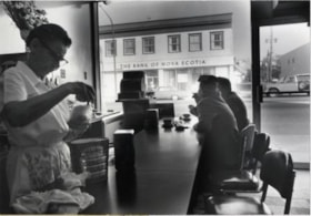
Popular Cafe
https://search.heritageburnaby.ca/link/archivedescription79326
- Repository
- City of Burnaby Archives
- Date
- October 1976
- Collection/Fonds
- Burnaby Public Library Contemporary Visual Archive Project
- Description Level
- Item
- Physical Description
- 1 photograph : b&w ; 11 x 16 cm mounted on cardboard
- Scope and Content
- Photograph shows the interior of the Popular Cafe at 4010 Hastings Street. The Bank of Nova Scotia can been seen across the street through the Cafe window.
- Repository
- City of Burnaby Archives
- Date
- October 1976
- Collection/Fonds
- Burnaby Public Library Contemporary Visual Archive Project
- Physical Description
- 1 photograph : b&w ; 11 x 16 cm mounted on cardboard
- Description Level
- Item
- Record No.
- 556-242
- Access Restriction
- No restrictions
- Reproduction Restriction
- Reproduce for fair dealing purposes only
- Accession Number
- 2013-13
- Scope and Content
- Photograph shows the interior of the Popular Cafe at 4010 Hastings Street. The Bank of Nova Scotia can been seen across the street through the Cafe window.
- Media Type
- Photograph
- Photographer
- Cook, Alan
- Notes
- Scope note taken directly from BPL photograph description.
- 1 b&w copy negative : 10 x 12.5 cm accompanying
- Geographic Access
- Hastings Street
- Street Address
- 4010 Hastings Street
- Historic Neighbourhood
- Vancouver Heights (Historic Neighbourhood)
- Planning Study Area
- Willingdon Heights Area
Images


Burnaby Mountain Park and Centennial Pavilion
https://search.heritageburnaby.ca/link/archivedescription37408
- Repository
- City of Burnaby Archives
- Date
- 1970
- Collection/Fonds
- Burnaby Historical Society fonds
- Description Level
- Item
- Physical Description
- 1 photograph : col. postcard ; 9 x 14 cm
- Scope and Content
- Photographic postcard of the Burnaby Mountain Park sign a Centennial Pavilion. The caption on the back of the postcard reads: "The Centennial Pavilion was built in 1958 during British Columbia's Centenary. It is situated on Burnaby Mountain at an elevation of 1000 feet. Numerous footpaths througho…
- Repository
- City of Burnaby Archives
- Date
- 1970
- Collection/Fonds
- Burnaby Historical Society fonds
- Subseries
- Robert Prittie subseries
- Physical Description
- 1 photograph : col. postcard ; 9 x 14 cm
- Description Level
- Item
- Record No.
- 369-007
- Access Restriction
- No restrictions
- Reproduction Restriction
- Reproduce for fair dealing purposes only
- Accession Number
- BHS1999-01
- Scope and Content
- Photographic postcard of the Burnaby Mountain Park sign a Centennial Pavilion. The caption on the back of the postcard reads: "The Centennial Pavilion was built in 1958 during British Columbia's Centenary. It is situated on Burnaby Mountain at an elevation of 1000 feet. Numerous footpaths throughout the beautifully landscaped grounds lead to interesting view points which provide magnificent scenery of Burrard Inlet, Coast Range Mountains, City of Vancouver, and other surrounding Municipalities."
- Subjects
- Symbols - Flags
- Documentary Artifacts - Postcards
- Buildings - Recreational
- Advertising Medium - Signs and Signboards
- Media Type
- Photograph
- Photographer
- George Allen Aerial Photos Limited
- Notes
- Title based on caption
- Geographic Access
- Burnaby Mountain Conservation Area
- Centennial Way
- Street Address
- 100 Centennial Way
- Planning Study Area
- Burnaby Mountain Area
Images
