More like 'Ken Shymka at Still Creek'
Narrow Results By
Decade
- 2020s 62
- 2010s 108
- 2000s 490
- 1990s 497
- 1980s 277
- 1970s 489
- 1960s 331
- 1950s 288
- 1940s 474
- 1930s 420
- 1920s 495
- 1910s 396
- 1900s 207
- 1890s 37
- 1880s 32
- 1870s 5
- 1860s 5
- 1850s 2
- 1840s 1
- 1830s 1
- 1820s 1
- 1810s 2
- 1800s 2
- 1790s 2
- 1780s 2
- 1770s 2
- 1760s 2
- 1750s 2
- 1740s 2
- 1730s 2
- 1720s 2
- 1710s 2
- 1700s 2
- 1690s 2
- 1680s 2
- 1670s 2
- 1660s 2
- 1650s 2
- 1640s 2
- 1630s 2
- 1620s 2
- 1610s 2
- 1600s 2
- 1590s 1
- 1580s 1
- 1570s 1
- 1560s 1
- 1550s 1
- 1540s 1
- 1530s 1
- 1520s 1
- 1510s 1
- 1500s 1
- 1490s 1
- 1480s 1
Subject
- Academic Disciplines 1
- Accidents 6
- Accidents - Automobile Accidents 11
- Adornment 3
- Adornment - Jewelry 2
- Adornment - Lapel Pins 4
- Advertising Medium 16
- Advertising Medium - Business Cards 8
- Advertising Medium - Flyer 2
- Advertising Medium - Signs and Signboards 45
- Aerial Photographs 36
- Agricultural Tools and Equipment 29
![Photographer on foggy Burnaby Mountain, [1999] thumbnail](/media/hpo/_Data/_Archives_Images/_Unrestricted/535/535-3116.jpg?width=280)
Photographer on foggy Burnaby Mountain
https://search.heritageburnaby.ca/link/archivedescription98036
- Repository
- City of Burnaby Archives
- Date
- [1999]
- Collection/Fonds
- Burnaby NewsLeader photograph collection
- Description Level
- Item
- Physical Description
- 1 photograph (tiff) : col.
- Scope and Content
- Photograph of a photographer on Burnaby Mountain. The person is taking a photograph of the skyline, where the tops of Vancouver office towers are visible above a blanket of fog.
- Repository
- City of Burnaby Archives
- Date
- [1999]
- Collection/Fonds
- Burnaby NewsLeader photograph collection
- Physical Description
- 1 photograph (tiff) : col.
- Description Level
- Item
- Record No.
- 535-3116
- Access Restriction
- No restrictions
- Reproduction Restriction
- No restrictions
- Accession Number
- 2018-12
- Scope and Content
- Photograph of a photographer on Burnaby Mountain. The person is taking a photograph of the skyline, where the tops of Vancouver office towers are visible above a blanket of fog.
- Media Type
- Photograph
- Photographer
- Bartel, Mario
- Notes
- Title based on caption
- Collected by editorial for use in a December 1999 issue of the Burnaby NewsLeader
- Caption from metadata: "The low fog that has shrouded much of the Lower Mainland for more than a week has been a lure for photographers atop Burnaby Mountain, who are able to capture a unique view of Burnaby."
- Geographic Access
- Burnaby Mountain Conservation Area
- Planning Study Area
- Burnaby Mountain Area
Images
![Photographer on foggy Burnaby Mountain, [1999] thumbnail](/media/hpo/_Data/_Archives_Images/_Unrestricted/535/535-3116.jpg)
![Bob Baillie with City of Burnaby traffic camera, [2002] thumbnail](/media/hpo/_Data/_Archives_Images/_Unrestricted/535/535-2817.jpg?width=280)
Bob Baillie with City of Burnaby traffic camera
https://search.heritageburnaby.ca/link/archivedescription97478
- Repository
- City of Burnaby Archives
- Date
- [2002]
- Collection/Fonds
- Burnaby NewsLeader photograph collection
- Description Level
- Item
- Physical Description
- 1 photograph (tiff) : col.
- Scope and Content
- Photograph of Bob Baillie, the supervisor of Traffic Engineering for the City of Burnaby, holding up one of the City's new Autoscope traffic management cameras. Baillie is standing on the pedestrian overpass over Canada Way by the City Hall complex.
- Repository
- City of Burnaby Archives
- Date
- [2002]
- Collection/Fonds
- Burnaby NewsLeader photograph collection
- Physical Description
- 1 photograph (tiff) : col.
- Description Level
- Item
- Record No.
- 535-2817
- Access Restriction
- No restrictions
- Reproduction Restriction
- No restrictions
- Accession Number
- 2018-12
- Scope and Content
- Photograph of Bob Baillie, the supervisor of Traffic Engineering for the City of Burnaby, holding up one of the City's new Autoscope traffic management cameras. Baillie is standing on the pedestrian overpass over Canada Way by the City Hall complex.
- Subjects
- Photographic Tools and Equipment - Camera
- Occupations - Civic Workers
- Public Services - Public Works
- Media Type
- Photograph
- Photographer
- Bartel, Mario
- Notes
- Title based on caption
- Collected by editorial for use in an October 2002 issue of the Burnaby NewsLeader
- Caption from metadata: "Bob Baillie, Burnaby's Supervisor of Traffic Engineering, shows off one of the city's Autoscope traffic management cameras which are being installed at major intersections. The cameras, mounted on light standards, replace the old wire loops that were cut into the pavement."
- Geographic Access
- Canada Way
- Historic Neighbourhood
- Burnaby Lake (Historic Neighbourhood)
- Planning Study Area
- Douglas-Gilpin Area
Images
![Bob Baillie with City of Burnaby traffic camera, [2002] thumbnail](/media/hpo/_Data/_Archives_Images/_Unrestricted/535/535-2817.jpg)
![Arthur Francis Peers, [1927] thumbnail](/media/hpo/_Data/_Archives_Images/_Unrestricted/001/020-171.jpg?width=280)
Arthur Francis Peers
https://search.heritageburnaby.ca/link/archivedescription34464
- Repository
- City of Burnaby Archives
- Date
- [1927]
- Collection/Fonds
- Burnaby Historical Society fonds
- Description Level
- Item
- Physical Description
- 1 photograph : sepia ; 6 x 11.8 cm on page 17.5 x 26.2 cm
- Scope and Content
- Photograph of Arthur Francis Peers standing near railway tracks at an unknown location. Snow can be seen covering the ground and Arthur is pictured wearing winter jacket, boots, hat and mittens. In his right hand he is holding a box camera and he is smoking a pipe. Throughout the late 1920s, Arthu…
- Repository
- City of Burnaby Archives
- Date
- [1927]
- Collection/Fonds
- Burnaby Historical Society fonds
- Subseries
- Peers family subseries
- Physical Description
- 1 photograph : sepia ; 6 x 11.8 cm on page 17.5 x 26.2 cm
- Description Level
- Item
- Record No.
- 020-171
- Access Restriction
- No restrictions
- Reproduction Restriction
- No known restrictions
- Accession Number
- BHS2007-04
- Scope and Content
- Photograph of Arthur Francis Peers standing near railway tracks at an unknown location. Snow can be seen covering the ground and Arthur is pictured wearing winter jacket, boots, hat and mittens. In his right hand he is holding a box camera and he is smoking a pipe. Throughout the late 1920s, Arthur Peers travelled throughout the Fraser Valley, British Columbia during the construction of the Trans-Provincial Highway and documented a lot of the work through his photographs. A caption to this picture reads: "Breaking camp."
- Media Type
- Photograph
- Notes
- Title based on contents of photograph
Images
![Arthur Francis Peers, [1927] thumbnail](/media/hpo/_Data/_Archives_Images/_Unrestricted/001/020-171.jpg)
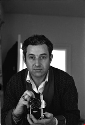
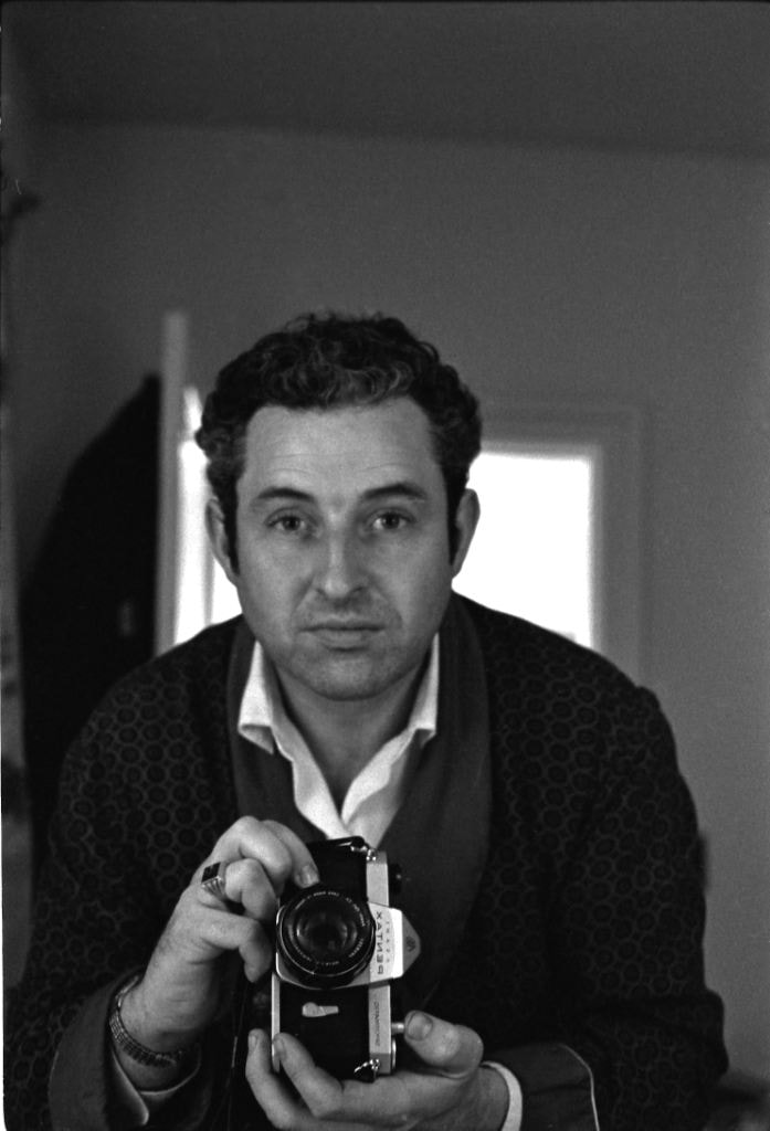
Harold Johnston
https://search.heritageburnaby.ca/link/archivedescription51472
- Repository
- City of Burnaby Archives
- Date
- 1969
- Collection/Fonds
- Harold H. Johnston fonds
- Description Level
- Item
- Physical Description
- 1 photograph (jpeg) : b&w
- Scope and Content
- Photograph is a self-portrait of photographer, Harold H. Johnston, taken while looking into a mirror. Harold is seen holding a 35mm Pentax camera and standing in front of an open door. This photograph was most likely taken inside the Johnston family home at 4447 Venables Street.
- Repository
- City of Burnaby Archives
- Date
- 1969
- Collection/Fonds
- Harold H. Johnston fonds
- Physical Description
- 1 photograph (jpeg) : b&w
- Description Level
- Item
- Record No.
- 483-073
- Access Restriction
- No restrictions
- Reproduction Restriction
- No reproduction permitted
- Accession Number
- 2008-08
- Scope and Content
- Photograph is a self-portrait of photographer, Harold H. Johnston, taken while looking into a mirror. Harold is seen holding a 35mm Pentax camera and standing in front of an open door. This photograph was most likely taken inside the Johnston family home at 4447 Venables Street.
- Names
- Johnston, Harold H.
- Media Type
- Photograph
- Photographer
- Johnston, Harold H.
- Notes
- Title based on contents of photograph
- Geographic Access
- Venables Street
- Street Address
- 4447 Venables Street
- Historic Neighbourhood
- Vancouver Heights (Historic Neighbourhood)
- Planning Study Area
- Willingdon Heights Area
Images
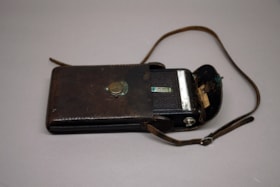
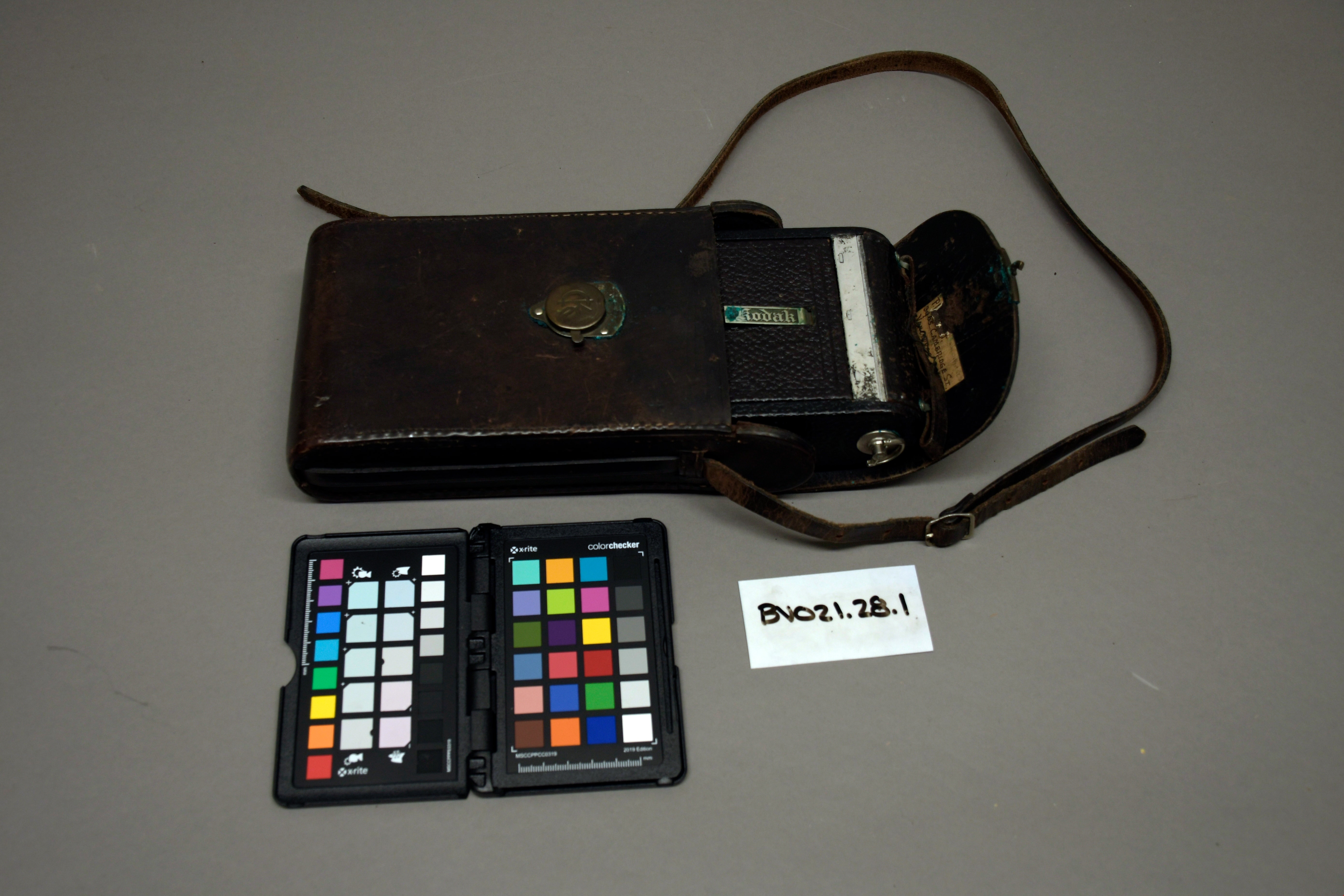
camera
https://search.heritageburnaby.ca/link/museumartifact91515
- Repository
- Burnaby Village Museum
- Accession Code
- BV021.28.1
- Description
- A Kodak camera inside of a brown leather camera case with a long shoulder strap. The camera case opens with a round metal clasp at the front top-centre. The rectangular camera fits snugly inside the case.
- Object History
- This camera belonged to Percy Mallett who immigrated to Okotoks, Alberta from Cornwall, England. He married Alice Mallett (nee Lowry) and moved to Vancouver, BC in 1910. The couple later moved to Burnaby to raise their family in 1915. They had three children.
- Classification
- Photographic T&E - - Camera Equipment
- Object Term
- Camera
- Marks/Labels
- Kodak
- Colour
- Brown
- Measurements
- height: 24 cm width: 13 cm depth: 5.5 cm
- Names
- Mallett, Percy
- Historic Neighbourhood
- Vancouver Heights (Historic Neighbourhood)
- Planning Study Area
- Burnaby Heights Area
Images

![Burnaby creek conservationists, [2002] thumbnail](/media/hpo/_Data/_Archives_Images/_Unrestricted/535/535-1959-1.jpg?width=280)
Burnaby creek conservationists
https://search.heritageburnaby.ca/link/archivedescription96276
- Repository
- City of Burnaby Archives
- Date
- [2002]
- Collection/Fonds
- Burnaby NewsLeader photograph collection
- Description Level
- File
- Physical Description
- 4 photographs (tiff) : col.
- Scope and Content
- File contains photographs of volunteer conservationists with the Eagle Creek Streamkeepers, Byrne Creek Streamkeepers, and Sapperton Fish & Game Club at work in the Lake City area by Eagle Creek and the Brunette River. Photographs depict Nick Kvenich, of the Eagle Creek Streamkeepers, in a creek; m…
- Repository
- City of Burnaby Archives
- Date
- [2002]
- Collection/Fonds
- Burnaby NewsLeader photograph collection
- Physical Description
- 4 photographs (tiff) : col.
- Description Level
- File
- Record No.
- 535-1959
- Access Restriction
- No restrictions
- Reproduction Restriction
- No restrictions
- Accession Number
- 2018-12
- Scope and Content
- File contains photographs of volunteer conservationists with the Eagle Creek Streamkeepers, Byrne Creek Streamkeepers, and Sapperton Fish & Game Club at work in the Lake City area by Eagle Creek and the Brunette River. Photographs depict Nick Kvenich, of the Eagle Creek Streamkeepers, in a creek; members of the Byrne Creek Streamkeepers observing a storm drain; and Elmer Rudolf feeding fish at a Sapperton Fish & Game Club hatchery.
- Subjects
- Geographic Features - Creeks
- Geographic Features - Lakes and Ponds
- Geographic Features - Ravines
- Geographic Features - Streams
- Media Type
- Photograph
- Photographer
- Bartel, Mario
- Notes
- Title based on caption
- Collected by editorial for use in a March 2002 issue of the Burnaby NewsLeader
- Caption from metadata for 535-1959-1: "Nick Kvenich is one of the founding members of the Eagle Creek Streamkeepers, which is looking to preserve the habitat of the creek that runs down from Squint Lake into a ravine below the Lake City industrial area."
- Caption from metadata for 535-1959-2: "Joan Carne (r) and Louise Towell, of the Byrne Creek Streamkeepers, examine a storm drain in an industrial area above the creek. The habitat faces constant pressure from businesses and homeowners who pour solvents, soaps and substances into the drains without thought to the consequences."
- Caption from metadata for 535-1959-3: "Nick Kvenich, one of the founding members of the Eagle Creek Streamkeepers, climbs through a fallen tree that is blocking a trail that runs alongside the creek, in a ravine below the Lake City industrial area. Although the tree will eventually be cleared by the GVRD, Kvenich says he prefers if such obstacles be left alone, as they would discourage people who might abuse the habitat."
- Caption from metadata for 535-1959-4: "Elmer Rudolf feeds a new batch of coho fry at the Sapperton Fish & Game Club's hatchery, near the Brunette River. The fry are normally fed by a timed conveyor belt, but that is supplemented by hand feedings to give the weaker fish a chance."
- Geographic Access
- Brunette River
- Eagle Creek
- Planning Study Area
- Lake City Area
Images
![Burnaby creek conservationists, [2002] thumbnail](/media/hpo/_Data/_Archives_Images/_Unrestricted/535/535-1959-1.jpg)
![Byrne Creek Streamkeepers, [2001] thumbnail](/media/hpo/_Data/_Archives_Images/_Unrestricted/535/535-2194-1.jpg?width=280)
Byrne Creek Streamkeepers
https://search.heritageburnaby.ca/link/archivedescription96572
- Repository
- City of Burnaby Archives
- Date
- [2001]
- Collection/Fonds
- Burnaby NewsLeader photograph collection
- Description Level
- File
- Physical Description
- 2 photographs (tiff) : col.
- Scope and Content
- File contains members of the Byrne Creek Streamkeepers during their work to protect the waterways and salmon in the area. Photographs depict Bob Fuller checking a waterflow measuring gauge and Joan Carne standing in the overflow channel at the salmon rearing ponds below Marine Drive.
- Repository
- City of Burnaby Archives
- Date
- [2001]
- Collection/Fonds
- Burnaby NewsLeader photograph collection
- Physical Description
- 2 photographs (tiff) : col.
- Description Level
- File
- Record No.
- 535-2194
- Access Restriction
- No restrictions
- Reproduction Restriction
- No restrictions
- Accession Number
- 2018-12
- Scope and Content
- File contains members of the Byrne Creek Streamkeepers during their work to protect the waterways and salmon in the area. Photographs depict Bob Fuller checking a waterflow measuring gauge and Joan Carne standing in the overflow channel at the salmon rearing ponds below Marine Drive.
- Subjects
- Persons - Volunteers
- Geographic Features - Creeks
- Geographic Features - Lakes and Ponds
- Geographic Features - Streams
- Media Type
- Photograph
- Photographer
- Bartel, Mario
- Notes
- Title based on caption
- Collected by editorial for use in a March 2001 issue of the Burnaby NewsLeader
- Caption from metadata for 535-2194-1: "Bob Fuller, of the Byrne Creek Streamkeepers, checks the guage that measures the flow of water which is released from the holding pond below Marine Drive to the salmon spawning beds downstream."
- Caption from metadata for 535-2194-2: "Joan Carne of the Byrne Creek Streamkeepers stands in the overflow channel at the salmon rearing ponds below Marine Drive. Although last week's chemical spill into Byrne Creek didn't reach the ponds, Carne says it's a constant battle to educate people to take care of the area's creeks and streams."
- Geographic Access
- Marine Drive
- Byrne Creek
- Planning Study Area
- Stride Hill Area
Images
![Byrne Creek Streamkeepers, [2001] thumbnail](/media/hpo/_Data/_Archives_Images/_Unrestricted/535/535-2194-1.jpg)
![Land surveyor on a road, [1999] thumbnail](/media/hpo/_Data/_Archives_Images/_Unrestricted/535/535-3313.jpg?width=280)
Land surveyor on a road
https://search.heritageburnaby.ca/link/archivedescription98246
- Repository
- City of Burnaby Archives
- Date
- [1999]
- Collection/Fonds
- Burnaby NewsLeader photograph collection
- Description Level
- Item
- Physical Description
- 1 photograph (tiff) : b&w
- Scope and Content
- Photograph of an unidentified land surveyor standing behind a land surveying total station at the curve of a road.
- Repository
- City of Burnaby Archives
- Date
- [1999]
- Collection/Fonds
- Burnaby NewsLeader photograph collection
- Physical Description
- 1 photograph (tiff) : b&w
- Description Level
- Item
- Record No.
- 535-3313
- Access Restriction
- No restrictions
- Reproduction Restriction
- No restrictions
- Accession Number
- 2018-12
- Scope and Content
- Photograph of an unidentified land surveyor standing behind a land surveying total station at the curve of a road.
- Media Type
- Photograph
- Notes
- Title based on contents of photograph
- Collected by editorial for use in a September 1999 issue of the Burnaby NewsLeader
Images
![Land surveyor on a road, [1999] thumbnail](/media/hpo/_Data/_Archives_Images/_Unrestricted/535/535-3313.jpg)
![Mark Angelo in Deer Lake Brook, [2002] thumbnail](/media/hpo/_Data/_Archives_Images/_Unrestricted/535/535-2603.jpg?width=280)
Mark Angelo in Deer Lake Brook
https://search.heritageburnaby.ca/link/archivedescription97075
- Repository
- City of Burnaby Archives
- Date
- [2002]
- Collection/Fonds
- Burnaby NewsLeader photograph collection
- Description Level
- Item
- Physical Description
- 1 photograph (tiff) : col.
- Scope and Content
- Photograph of conservationist Mark Angelo standing in Deer Lake Brook.
- Repository
- City of Burnaby Archives
- Date
- [2002]
- Collection/Fonds
- Burnaby NewsLeader photograph collection
- Physical Description
- 1 photograph (tiff) : col.
- Description Level
- Item
- Record No.
- 535-2603
- Access Restriction
- No restrictions
- Reproduction Restriction
- No restrictions
- Accession Number
- 2018-12
- Scope and Content
- Photograph of conservationist Mark Angelo standing in Deer Lake Brook.
- Subjects
- Environmental Issues - Environmental Protection
- Environmental Issues
- Geographic Features - Streams
- Geographic Features - Creeks
- Names
- Angelo, Mark
- Media Type
- Photograph
- Photographer
- Ray, Steve
- Notes
- Title based on caption
- Collected by editorial for use in a July 2002 issue of the Burnaby NewsLeader
- Caption from metadata: "Mark Angelo in Deer Lake Brook, one of the streams that may be affected by the Federal Government cuts to community stream keepers."
- Geographic Access
- Deer Lake Brook
- Historic Neighbourhood
- Burnaby Lake (Historic Neighbourhood)
- Planning Study Area
- Morley-Buckingham Area
Images
![Mark Angelo in Deer Lake Brook, [2002] thumbnail](/media/hpo/_Data/_Archives_Images/_Unrestricted/535/535-2603.jpg)
![Still Creek conservation ceremony, [2001] thumbnail](/media/hpo/_Data/_Archives_Images/_Unrestricted/535/535-1572.jpg?width=280)
Still Creek conservation ceremony
https://search.heritageburnaby.ca/link/archivedescription95714
- Repository
- City of Burnaby Archives
- Date
- [2001]
- Collection/Fonds
- Burnaby NewsLeader photograph collection
- Description Level
- Item
- Physical Description
- 1 photograph (tiff) : col.
- Scope and Content
- Photograph of a member of the Outdoor Recreation Council of BC and Ian Waddell, Minister of the Environment, Lands and Parks, at Still Creek. They stand on a bridge over the water and are looking and gesturing toward something in the distance.
- Repository
- City of Burnaby Archives
- Date
- [2001]
- Collection/Fonds
- Burnaby NewsLeader photograph collection
- Physical Description
- 1 photograph (tiff) : col.
- Description Level
- Item
- Record No.
- 535-1572
- Access Restriction
- No restrictions
- Reproduction Restriction
- No restrictions
- Accession Number
- 2018-12
- Scope and Content
- Photograph of a member of the Outdoor Recreation Council of BC and Ian Waddell, Minister of the Environment, Lands and Parks, at Still Creek. They stand on a bridge over the water and are looking and gesturing toward something in the distance.
- Subjects
- Geographic Features - Creeks
- Geographic Features - Streams
- Officials - Elected Officials
- Events
- Names
- Still Creek
- Media Type
- Photograph
- Photographer
- Bartel, Mario
- Notes
- Title based on caption
- Collected by editorial for use in a January 2001 issue of the Burnaby NewsLeader
- Caption from metadata: "Mark Angelo, of the Outdoor Recreation Council of BC, discusses some of the enhancements that have revived Still Creek with Ian Waddell, the Minister of Environment, Lands and Parks at a ceremony to announce a new 15-30 metre wide protection area on the banks of urban streams."
- Geographic Access
- Still Creek
Images
![Still Creek conservation ceremony, [2001] thumbnail](/media/hpo/_Data/_Archives_Images/_Unrestricted/535/535-1572.jpg)
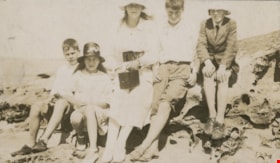
Children on the beach
https://search.heritageburnaby.ca/link/archivedescription39270
- Repository
- City of Burnaby Archives
- Date
- 1920
- Collection/Fonds
- Peers Family and Hill Family fonds
- Description Level
- Item
- Physical Description
- 1 photograph : b&w ; 6 x 10.2 cm on page 24.5 x 32.5 cm (pasted in album)
- Scope and Content
- Photograph of five children sitting on the beach. The girl in the middle is holding a box camera on her lap.
- Repository
- City of Burnaby Archives
- Date
- 1920
- Collection/Fonds
- Peers Family and Hill Family fonds
- Physical Description
- 1 photograph : b&w ; 6 x 10.2 cm on page 24.5 x 32.5 cm (pasted in album)
- Description Level
- Item
- Record No.
- 477-589
- Access Restriction
- No restrictions
- Reproduction Restriction
- No known restrictions
- Accession Number
- 2007-12
- Scope and Content
- Photograph of five children sitting on the beach. The girl in the middle is holding a box camera on her lap.
- Media Type
- Photograph
- Notes
- Title based on contents of photograph
Images

Dave Gray and Bob Wood
https://search.heritageburnaby.ca/link/archivedescription35693
- Repository
- City of Burnaby Archives
- Date
- May 1927 (date of original), copied 1986
- Collection/Fonds
- Burnaby Historical Society fonds
- Description Level
- Item
- Physical Description
- 1 photograph : b&w ; 12.7 x 17.8 cm print
- Scope and Content
- Photograph of Dave Gray and Bob Wood on a hike to the Lions peaks in West Vancouver. Dave Gray has his pipe clenched in his teeth, as Bob Wood points a box camera at him. The third member of hiking party, Art Hilton (not pictured), took this photograph. Dave Gray, a famous baseball player and late…
- Repository
- City of Burnaby Archives
- Date
- May 1927 (date of original), copied 1986
- Collection/Fonds
- Burnaby Historical Society fonds
- Subseries
- Pioneer Tales subseries
- Physical Description
- 1 photograph : b&w ; 12.7 x 17.8 cm print
- Description Level
- Item
- Record No.
- 204-551
- Access Restriction
- No restrictions
- Reproduction Restriction
- Reproduce for fair dealing purposes only
- Accession Number
- BHS1988-03
- Scope and Content
- Photograph of Dave Gray and Bob Wood on a hike to the Lions peaks in West Vancouver. Dave Gray has his pipe clenched in his teeth, as Bob Wood points a box camera at him. The third member of hiking party, Art Hilton (not pictured), took this photograph. Dave Gray, a famous baseball player and later teacher, was an all-round athlete who once taught Bob Wood. David Gray Park and swimming pool in South Burnaby were named after him.
- Media Type
- Photograph
- Photographer
- Hilton, Art
- Notes
- Title based on contents of photograph
Images


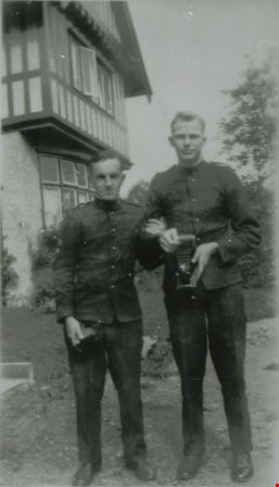
Chip and Roy at Hart House
https://search.heritageburnaby.ca/link/archivedescription38004
- Repository
- City of Burnaby Archives
- Date
- 1929 (date of original), copied 1991
- Collection/Fonds
- Burnaby Historical Society fonds
- Description Level
- Item
- Physical Description
- 1 photograph : b&w ; 4.6 x 2.6 cm print on contact sheet 20.5 x 26.4 cm
- Scope and Content
- Photograph of Chip and Roy, two Australian soldiers or sailors, at Hart House. They are in uniform, and one of them is holding a camera.
- Repository
- City of Burnaby Archives
- Date
- 1929 (date of original), copied 1991
- Collection/Fonds
- Burnaby Historical Society fonds
- Subseries
- Burnaby Image Bank subseries
- Physical Description
- 1 photograph : b&w ; 4.6 x 2.6 cm print on contact sheet 20.5 x 26.4 cm
- Description Level
- Item
- Record No.
- 370-591
- Access Restriction
- No restrictions
- Reproduction Restriction
- No known restrictions
- Accession Number
- BHS1999-03
- Scope and Content
- Photograph of Chip and Roy, two Australian soldiers or sailors, at Hart House. They are in uniform, and one of them is holding a camera.
- Subjects
- Photographic Tools and Equipment - Cameras
- Occupations - Military Personnel
- Clothing - Military Uniforms
- Media Type
- Photograph
- Notes
- Title based on contents of photograph
- 1 b&w copy negative accompanying
- Geographic Access
- Deer Lake Avenue
- Street Address
- 6664 Deer Lake Avenue
- Historic Neighbourhood
- Burnaby Lake (Historic Neighbourhood)
- Planning Study Area
- Morley-Buckingham Area
Images
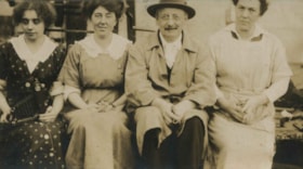
Munitions - New Westminster 1917
https://search.heritageburnaby.ca/link/archivedescription39164
- Repository
- City of Burnaby Archives
- Date
- 1917
- Collection/Fonds
- Peers Family and Hill Family fonds
- Description Level
- Item
- Physical Description
- 1 photograph : sepia ; 5.4 x 9.7 cm on page 24.5 x 32.5 cm (pasted in album)
- Scope and Content
- Photograph of three women and one man (all unknown) seated on a bench. The woman on the left has a camera with bellows, which looks to be a 1A Autographic Kodak Jr. folding camera resting on her lap, and the man is holding pipe. The photograph has been captioned as "Munitions - New Westminster 1917…
- Repository
- City of Burnaby Archives
- Date
- 1917
- Collection/Fonds
- Peers Family and Hill Family fonds
- Physical Description
- 1 photograph : sepia ; 5.4 x 9.7 cm on page 24.5 x 32.5 cm (pasted in album)
- Description Level
- Item
- Record No.
- 477-483
- Access Restriction
- No restrictions
- Reproduction Restriction
- No known restrictions
- Accession Number
- 2007-12
- Scope and Content
- Photograph of three women and one man (all unknown) seated on a bench. The woman on the left has a camera with bellows, which looks to be a 1A Autographic Kodak Jr. folding camera resting on her lap, and the man is holding pipe. The photograph has been captioned as "Munitions - New Westminster 1917."
- Subjects
- Wars - World War, 1914-1918
- Photographic Tools and Equipment - Cameras
- Occupations - War Workers
- Media Type
- Photograph
- Notes
- Title based on caption accompanying photograph
Images


Arthur Francis Peers
https://search.heritageburnaby.ca/link/archivedescription34492
- Repository
- City of Burnaby Archives
- Date
- 1925
- Collection/Fonds
- Burnaby Historical Society fonds
- Description Level
- Item
- Physical Description
- 1 photograph : sepia ; 7.8 x 13.5 cm on page 17.5 x 26.4 cm
- Scope and Content
- Photograph of Arthur Francis Peers on a raft on Texas Lake. Arthur Peers, later of the Royal Canadian Navy and Order of the British Empire worked on the surveys for the construction of the Trans-Provincial Highway during the late 1920s and documented a lot of the work through his photographs.
- Repository
- City of Burnaby Archives
- Date
- 1925
- Collection/Fonds
- Burnaby Historical Society fonds
- Subseries
- Peers family subseries
- Physical Description
- 1 photograph : sepia ; 7.8 x 13.5 cm on page 17.5 x 26.4 cm
- Description Level
- Item
- Record No.
- 020-199
- Access Restriction
- No restrictions
- Reproduction Restriction
- No known restrictions
- Accession Number
- BHS2007-04
- Scope and Content
- Photograph of Arthur Francis Peers on a raft on Texas Lake. Arthur Peers, later of the Royal Canadian Navy and Order of the British Empire worked on the surveys for the construction of the Trans-Provincial Highway during the late 1920s and documented a lot of the work through his photographs.
- Media Type
- Photograph
- Notes
- Title based on caption accompanying photograph
Images

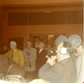
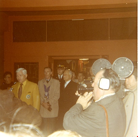
Governor General Roland Michener and officials at Heritage Village opening
https://search.heritageburnaby.ca/link/museumdescription13569
- Repository
- Burnaby Village Museum
- Date
- 19 November 1971
- Collection/Fonds
- Donald Copan collection
- Description Level
- Item
- Physical Description
- 1 photograph : col. ; 8.9 x 8.9 cm
- Scope and Content
- Photograph of officials at the opening ceremony for Heritage Village Museum (Burnaby Village Museum). Burnaby Centennial '71 Committee member Sandy Stewart (in yellow jacket) is standing next to Mayor Bob Prittie and Governor General Roland Michener (centre, in black suit). A man is holding a telev…
- Repository
- Burnaby Village Museum
- Collection/Fonds
- Donald Copan collection
- Series
- Copan album series
- Description Level
- Item
- Physical Description
- 1 photograph : col. ; 8.9 x 8.9 cm
- Scope and Content
- Photograph of officials at the opening ceremony for Heritage Village Museum (Burnaby Village Museum). Burnaby Centennial '71 Committee member Sandy Stewart (in yellow jacket) is standing next to Mayor Bob Prittie and Governor General Roland Michener (centre, in black suit). A man is holding a television camera on his shoulder and filming the event.
- Subjects
- Events - Openings
- Buildings - Civic - Museums
- Telecommunication Tools and Equipment - Televisions
- Photographic Tools and Equipment
- Names
- Prittie, Robert W. "Bob"
- Michener, Daniel Roland "Roland"
- Stewart, A.B. "Sandy"
- Burnaby Village Museum
- Accession Code
- BV005.54.461
- Access Restriction
- No restrictions
- Reproduction Restriction
- May be restricted by third party rights
- Date
- 19 November 1971
- Media Type
- Photograph
- Scan Resolution
- 600
- Scan Date
- August 11, 2020
- Scale
- 100
- Notes
- Title based on contents of photograph
Images
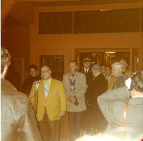
Governor General Roland Michener and officials at Heritage Village opening
https://search.heritageburnaby.ca/link/museumdescription13570
- Repository
- Burnaby Village Museum
- Date
- 19 November 1971
- Collection/Fonds
- Donald Copan collection
- Description Level
- Item
- Physical Description
- 1 photograph : col. ; 8.9 x 8.9 cm
- Scope and Content
- Photograph of officials at the opening ceremony for Heritage Village Museum (Burnaby Village Museum). Burnaby Centennial '71 Committee chair James Barrington is speaking from a microphone. Mayor Bob Prittie and Governor General Roland Michener are standing to the right. A man is holding a televisio…
- Repository
- Burnaby Village Museum
- Collection/Fonds
- Donald Copan collection
- Series
- Copan album series
- Description Level
- Item
- Physical Description
- 1 photograph : col. ; 8.9 x 8.9 cm
- Scope and Content
- Photograph of officials at the opening ceremony for Heritage Village Museum (Burnaby Village Museum). Burnaby Centennial '71 Committee chair James Barrington is speaking from a microphone. Mayor Bob Prittie and Governor General Roland Michener are standing to the right. A man is holding a television camera on his shoulder and filming the event.
- Subjects
- Events - Openings
- Buildings - Civic - Museums
- Telecommunication Tools and Equipment - Televisions
- Photographic Tools and Equipment
- Names
- Prittie, Robert W. "Bob"
- Michener, Daniel Roland "Roland"
- Barrington, James Alfred "Jim"
- Burnaby Village Museum
- Accession Code
- BV005.54.462
- Access Restriction
- No restrictions
- Reproduction Restriction
- May be restricted by third party rights
- Date
- 19 November 1971
- Media Type
- Photograph
- Scan Resolution
- 600
- Scan Date
- August 11, 2020
- Scale
- 100
- Notes
- Title based on contents of photograph
Images

Interview with Joe Sadowski, 2017
https://search.heritageburnaby.ca/link/museumdescription5115
- Repository
- Burnaby Village Museum
- Date
- June 16, 2017
- Collection/Fonds
- Burnaby Village Museum fonds
- Description Level
- Item
- Physical Description
- 1 sound recording (mp3) (01:46.06 min)
- Scope and Content
- Recording is an interview with Joe Sadowski conducted by Burnaby Village Museum employee Rebeca Salas, June 16, 2017. Major themes discussed: the history of the Burnaby Park Advisory Association and the Group of Ten, and the ongoing conservation of Burnaby Lake. 00:00 – 3:05: Joe discusses his inv…
- Repository
- Burnaby Village Museum
- Collection/Fonds
- Burnaby Village Museum fonds
- Series
- Museum Oral Histories series
- Subseries
- Museum research interviews subseries
- Description Level
- Item
- Physical Description
- 1 sound recording (mp3) (01:46.06 min)
- Material Details
- Interviewer: Rebeca Salas Interviewee: Joe Sadowski Date of interview: June 16, 2017 Total Number of Tracks: 1 Total Length of all Tracks: 1:46:06
- Scope and Content
- Recording is an interview with Joe Sadowski conducted by Burnaby Village Museum employee Rebeca Salas, June 16, 2017. Major themes discussed: the history of the Burnaby Park Advisory Association and the Group of Ten, and the ongoing conservation of Burnaby Lake. 00:00 – 3:05: Joe discusses his involvement with the Association from its early days in the late 1960s. He describes the formation of the group, its original intentions, and its changing focus. 3:05 - 5:54: Joe recalls how the group decided to further their purpose by involving the public, and the rationale behind building a trail system. He explains how the Burnaby Outdoor Education Association was formed and describes its activities. 5:54 – 9:20: Joe relates how the Association was able to access federal funding for the trail. He shares his perspective about local businesses having changed their priorities since that time. 9:20 – 13:31: Joe discusses how the group expanded its base, and why it changed its name to the Burnaby Lake Advisory. He explains how the trail system came to be under the jurisdiction of Metro Parks, and why the name was changed to the Burnaby Lake Park Association. He describes the shift in the group’s composition and responsibilities. 13:31 – 17:06: Rebeca notes that the museum is interested in the reasons for the group coming together in the 1960s. Joe describes how the group’s plans regarding the lake informed their subsequent activities there. He talks about the changing attitude to pollution in the 1970s. 17:06 - 22:05: Joe describes what Burnaby Lake was like in the 1960s. He discusses its importance to migrating birds, and talks about the improvement to Still Creek. 22:05 – 29:48: Joe talks about the big Burnaby Lake Clean Up. He notes that the public’s changing attitudes have made further large clean-ups unnecessary. 29:48 – 32:00: Joe talks about the work of the Eagle Creek Streamkeepers, the Sapperton Fish and Game Club, The Semiahmoo Rod and Gun Club, and the Hyde Creek Watershed Society. He observes that game clubs have broader interests now than sport alone. 32:00 – 37:37: Joe discusses the return of salmon to the lake, the improvement in the quality of water, and the increased numbers of birds. He shares his perspective that the relationship of the public to the lake changed as visitors began to take ownership. 37:37 – 39:30: Joe talks about the importance of leadership in conservation efforts, discussing how Bob Gardner and Elmer Rudolph inspired people to become involved. He describes the positive results of volunteering. 39:30 – 41:48: Asked what he feels has made the biggest difference in improving the health of the lake, Joe describes the change in the attitude of the public and contrasts this new environmental awareness with that of people in other parts of the world. 41:48 – 47:46: Joe discusses the importance of the buffer zone, and of giving students the opportunity to be involved in efforts to remove invasive species and plant native ones. 47:46 – 56:10: Joe talks about the nesting box program. He notes that interacting with wildlife may influence people’s future behavior and describes the experience as cross-cultural. 56:10 – 58:17: Joe discusses the design of the trail around the lake. 58:17 – 1:02:32: Joe mentions the advisory role of Dr. Milton McLaren in the Association’s trail building work. He remarks on the importance to the project of people such as Tony Fabian and John Thomson. Joe also discusses the material used for the trail’s construction. 1:02:32 – 1:10:53: Joe describes the Association’s relationship with the Nature House and the Wildlife Rescue Centre. He recalls the acquisition of the Nature House building. 1:10:53 – 1:19:57: Asked about consultation, Joe describes the design and construction of the trail as the only subject in which the group’s expertise was deferred to. He discusses his concerns about dredging, and mentions the installation of squirrel nesting boxes as a successful enhancement project. 1:19:57 – 1:28:05: Joe talks about how the Burnaby Lake area has changed since he moved to Burnaby in 1964, and mentions some of the detrimental effects of development. He recalls the construction of the original observation tower by Aril Dalsvaag’s students at Burnaby Central Secondary School, talks about the current tower and discusses the success of the Association’s turtle nesting pad. 1:28:05 – 1:34:50: Joe discusses the introduced species in Burnaby Lake, and the efforts to eradicate them. He mentions the work of Bob Gunn, from B.C.I.T., a former student of Bob Gardner. 1:34:50 – 1:49:28: Asked about the substances used to control the mosquito population at Burnaby Lake, Joe voices his concerns about the effects of spraying, noting that the butterfly garden has been negatively affected by it in the past. He describes the origin of the garden. 1:40:28 – 1:46:06: Rebeca summarizes the interview and thanks Joe. Joe describes his hopes for the B.L.P.A. and the future of the lake. He reiterates the importance of preservation and accessibility and remarks on the number and diversity of the visitors.
- History
- Interviewee: Joe Sadowski is a founding member of the Burnaby Lake Park Association which was formerly named the Burnaby Outdoor Education Association. He has been recognized for his environmental efforts and was awarded the Community Stewardship Star in 2000 and 2004. Interviewer: Rebeca Salas is a MA student in the Department of Geography at Simon Fraser University. Rebeca is interested in the relationship between property and memory. Rebeca is an experienced researcher and oral history interviewer and has conducted several oral histories for Landscapes of Injustice Archive.
- Creator
- Burnaby Village Museum
- Subjects
- Environmental Issues
- Environmental Issues - Environmental Protection
- Geographic Features - Streams
- Geographic Features - Natural Waterways
- Geographic Features - Parks
- Responsibility
- Salas, Rebeca
- Geographic Access
- Burnaby Lake Regional Nature Park
- Burnaby Lake
- Accession Code
- BV018.18.1
- Access Restriction
- No restrictions
- Date
- June 16, 2017
- Media Type
- Sound Recording
Audio Tracks
Interview with Joe Sadowski, 2017, June 16, 2017
Interview with Joe Sadowski, 2017, June 16, 2017
https://search.heritageburnaby.ca/media/hpo/_Data/_BVM_Sound_Recordings/Oral_Histories/2018_0018_0001_001.mp3Interview with John Templeton, Alan James and Christine Leston by Kathy Bossort October 26, 2015 - Track 9
https://search.heritageburnaby.ca/link/oralhistory595
- Repository
- City of Burnaby Archives
- Date Range
- 1995-2015
- Length
- 0:12:28
- Summary
- This portion of the interview is about the Stoney Creek Environment Committee members’ discussion of how the history of the forest and natural area on Burnaby Mountain forms part of our appreciation for the mountain. They talk about the impact of the conservation area on adjacent urban areas such a…
- Repository
- City of Burnaby Archives
- Summary
- This portion of the interview is about the Stoney Creek Environment Committee members’ discussion of how the history of the forest and natural area on Burnaby Mountain forms part of our appreciation for the mountain. They talk about the impact of the conservation area on adjacent urban areas such as the neighbourhood of Forest Grove, and the future of the urban forest on Burnaby Mountain.
- Date Range
- 1995-2015
- Length
- 0:12:28
- Geographic Access
- Burnaby Mountain Conservation Area
- Stoney Creek
- Interviewer
- Bossort, Kathy
- Interview Date
- October 26, 2015
- Scope and Content
- Recording is of an interview with John Templeton, Alan James & Christine Leston, members of the Stoney Creek Environment Committee, conducted by Kathy Bossort. The three members of SCEC were among 23 participants interviewed as part of the Community Heritage Commission’s Burnaby Mountain Oral History Project. The interview is mainly about the history and work of the stream keeper group Stoney Creek Environment Committee (SCEC) and the Stoney Creek Environmental Working Group, and about SCEC’s founder Jennifer Atkinson. The interview is made richer by the complementary views of the three interviewees, John Templeton (SCEC Chair), Alan James (Member-at-Large - Education), and Christine Leston (Treasurer).
- Biographical Notes
- The Stoney Creek Environment Committee is a streamkeeper group and registered non-profit society dedicated to protecting and restoring viable salmon-bearing streams within the Stoney Creek Watershed. (Stoney Creek originates on Burnaby Mountain and is part of the Brunette watershed which empties into the Fraser River.) The volunteer group, formed in 1995, was guided by the tireless efforts of Jennifer Atchison (1938-2010) after whom the Jennifer Atchison Environmental Centre in North Burnaby is named. The volunteer members of SCEC monitor water quality, generate inventories and reports on the biophysical assets and health of the watershed, provide educational opportunities, enhance stream and stream bank habitat, and speak on behalf of the Stoney Creek watershed. One of its key events is The Great Salmon Send-Off, the release of young salmon into Stoney Creek in May, which celebrated its 25th anniversary in 2015. The Stoney Creek Environmental Working Group (1999-present), managed by the City of Burnaby, undertakes to coordinate the actions of all stakeholders in the Stoney Creek watershed. It is comprised of representatives from community groups, such as SCEC, governmental and institutional agencies, and industries who are committed to sustaining and improving the quality of the Stoney Creek watershed’s water, wildlife and environment. John Templeton, currently SCEC Chair, joined SCEC in 2004. He was born in Coleraine ,County Londonderry, Northern Ireland, in 1957, and after immigrating to Canada, came to live in Burnaby in 1992, first in Forest Grove (1992-2014) and then in Forest Hills. He works as a millwright. Alan James,Member-at-large - Education, joined SCEC in 2003 He was born in 1939 in Berkeley, California, and came to live in Burnaby in about 2000. He is a retired geophycisist and computer consultant. Christine Leston joined SCEC in 1997, serving first as Secretary and then as Treasurer. She was born in 1943 in Cheshire, England, and came to live in Burnaby in 1974, first in Greentree Village, then Simon Fraser Village (1974-2004) and now the Edmonds area. She is a retired technical writer.
- Total Tracks
- 9
- Total Length
- 2:08:27
- Interviewee Name
- Templeton, John R.
- James, Alan C.
- Leston, Christine
- Interview Location
- Jennifer Atchison Environmental Centre, Burnaby
- Interviewer Bio
- Kathy Bossort is a retired archivist living in Ladner, BC. She worked at the Delta Museum and Archives after graduating from SLAIS (UBC) in 2001 with Masters degrees in library science and archival studies. Kathy grew up in Calgary, Alberta, and, prior to this career change, she lived in the West Kootenays, earning her living as a cook for BC tourist lodges and work camps. She continues to be interested in oral histories as a way to fill the gaps in the written record and bring richer meaning to history.
- Collection/Fonds
- Community Heritage Commission Special Projects fonds
- Media Type
- Sound Recording
Audio Tracks
Track nine of interview with John Templeton, Alan James & Christine Leston
Track nine of interview with John Templeton, Alan James & Christine Leston
https://search.heritageburnaby.ca/media/hpo/_Data/_Archives_Oral_Histories/_Unrestricted/MSS196-006/MSS196-006_Track_9.mp3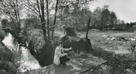
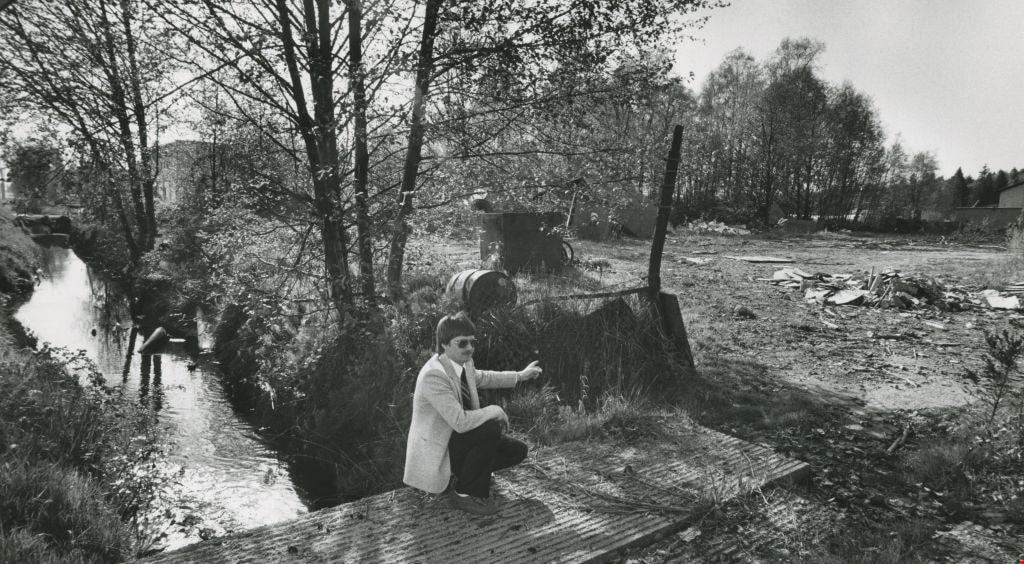
Burnaby municipal engineer
https://search.heritageburnaby.ca/link/archivedescription45977
- Repository
- City of Burnaby Archives
- Date
- April 1983
- Collection/Fonds
- Columbian Newspaper collection
- Description Level
- Item
- Physical Description
- 1 photograph : b&w ; 12.5 x 23 cm
- Scope and Content
- Photograph of a Burnaby municipal engineer crouched down on a bridge over a creek, pointing towards the area where the municipality planned to divert the creek (400 feet away). A newspaper clipping attached to the back of the photograph identifies the engineer as Ernie Olson, but there is some ques…
- Repository
- City of Burnaby Archives
- Date
- April 1983
- Collection/Fonds
- Columbian Newspaper collection
- Physical Description
- 1 photograph : b&w ; 12.5 x 23 cm
- Description Level
- Item
- Record No.
- 480-872
- Access Restriction
- No restrictions
- Reproduction Restriction
- Reproduce for fair dealing purposes only
- Accession Number
- 2003-02
- Scope and Content
- Photograph of a Burnaby municipal engineer crouched down on a bridge over a creek, pointing towards the area where the municipality planned to divert the creek (400 feet away). A newspaper clipping attached to the back of the photograph identifies the engineer as Ernie Olson, but there is some question as to its accuracy.
- Media Type
- Photograph
- Photographer
- Battistoni, Peter
- Notes
- Title based on contents of photograph
- Note on recto of photograph reads: "This Creek will be diverted 400 ft this way"
- Newspaper clipping attached to verso of photograph reads: "Burnaby municipal engineer Ernie Olson points to area where creek would be diverted, 400 feet from present site.
Images