More like 'City of Burnaby digital mapping system'
Narrow Results By
Decade
- 2020s 37
- 2010s 31
- 2000s 348
- 1990s 263
- 1980s 204
- 1970s 662
- 1960s 270
- 1950s 232
- 1940s 336
- 1930s 178
- 1920s 259
- 1910s 283
- 1900s 132
- 1890s 36
- 1880s 9
- 1870s 3
- 1860s 3
- 1850s 3
- 1840s 1
- 1830s 2
- 1820s 1
- 1810s 1
- 1800s 1
- 1790s 1
- 1780s 1
- 1770s 1
- 1760s 1
- 1750s 1
- 1740s 1
- 1730s 1
- 1720s 1
- 1710s 1
- 1700s 1
- 1690s 1
- 1680s 1
- 1670s 1
- 1660s 1
- 1650s 1
- 1640s 1
- 1630s 1
- 1620s 1
- 1610s 1
- 1600s 1
Subject
- Academic Disciplines 1
- Accidents 5
- Accidents - Automobile Accidents 11
- Adornment 4
- Adornment - Jewelry 4
- Adornment - Lapel Pins 4
- Advertising Medium 27
- Advertising Medium - Business Cards 7
- Advertising Medium - Flyer 1
- Advertising Medium - Poster 2
- Advertising Medium - Signs and Signboards 16
- Aerial Photographs 7

Capitol Hill Community Hall
https://search.heritageburnaby.ca/link/landmark563
- Repository
- Burnaby Heritage Planning
- Description
- Public building.
- Associated Dates
- 1948
- Street View URL
- Google Maps Street View
- Repository
- Burnaby Heritage Planning
- Geographic Access
- Howard Avenue
- Associated Dates
- 1948
- Description
- Public building.
- Heritage Value
- The Capitol Hill Community Hall was designed by local architect Harold Cullerne (1890-1976). After Cullerne returned from service during the First World War, he joined J.H. Bowman in a partnership that lasted from 1919 to 1934. After Bowman retired in 1934, Cullerne practiced on his own, continuing to work on schools and institutional buildings, such as the Art Deco Hollywood Theatre in Vancouver. In 1944, Cullerne designed a community hall for Capitol Hill; the scheme was delayed, and redesigned before it was finally built after the end of the Second World War. A simple front gabled roof hall structure, this hall is a monument to community spirit, erected by community members on a volunteer basis, and used for community events for over half a century. The hall replaced two earlier structures, both destroyed by fire, that had served the same purpose.
- Locality
- Capitol Hill
- Historic Neighbourhood
- Capitol Hill (Historic Neighbourhood)
- Planning Study Area
- Capitol Hill Area
- Architect
- Harold Cullerne
- Ownership
- Public (local)
- Street Address
- 361 Howard Avenue
- Street View URL
- Google Maps Street View
Images


E.W. Bateman House 'Elworth'
https://search.heritageburnaby.ca/link/landmark538
- Repository
- Burnaby Heritage Planning
- Description
- The E.W. Bateman House is a one-and-one-half storey wood-frame residence set within in a garden landscape. The house and its adjacent garage are the only historic buildings standing on their original site within the Burnaby Village Museum property.
- Associated Dates
- 1922
- Formal Recognition
- Heritage Designation, Community Heritage Register
- Other Names
- Edwin & Mary Bateman Residence
- Street View URL
- Google Maps Street View
- Repository
- Burnaby Heritage Planning
- Other Names
- Edwin & Mary Bateman Residence
- Geographic Access
- Deer Lake Avenue
- Associated Dates
- 1922
- Formal Recognition
- Heritage Designation, Community Heritage Register
- Enactment Type
- Bylaw No. 9807
- Enactment Date
- 23/11/1992
- Description
- The E.W. Bateman House is a one-and-one-half storey wood-frame residence set within in a garden landscape. The house and its adjacent garage are the only historic buildings standing on their original site within the Burnaby Village Museum property.
- Heritage Value
- The E.W. Bateman House was constructed in the Deer Lake Crescent subdivision, that was originally promoted in 1911 as an upper class suburban neighbourhood. It represents one of the first residential developments in the City of Burnaby that required buildings to be of a specific value, thus demonstrating the desire for exclusivity among the successful businessmen who chose to settle in the area. The house and grounds illustrate the reduced scale of upper-class residential construction at a time of modest returning prosperity that followed the end of the First World War, and the social, cultural, lifestyle and leisure sensibilities of the owners in the Deer Lake Crescent subdivision: such values as social aspiration, racial exclusivity, demonstration of architectural taste, and importance of a landscaped garden. The heritage value of the E.W. Bateman House is its comprehensive representation of an upper middle-class suburban residence of the early 1920s. It was built for retired CPR executive Edwin Wettenhall Bateman (1859-1957) and his wife, Mary (Dale) Bateman (1865-1935), by contractor William Dodson in 1922. The Bateman House was designed by English-born and trained architect Enoch Evans (1862-1939) of E. Evans and Son, and is an important surviving residential design by Evans, and a typical example of the eclectic Period Revival influences that were common to domestic architecture in the post-First World War era. The symmetry of the imposing front verandah, supported by exaggerated Ionic columns, gives the relatively-modest house an image of grandeur and formality. Named after Edwin Bateman’s birthplace in Cheshire, England, ‘Elworth’ also symbolizes allegiance to England and the patriotic tenor of the time. The heritage value for this house also lies in its interpretive value within the Burnaby Village Museum. The site is an important cultural feature for the interpretation of Burnaby’s heritage to the public. The E.W. Bateman House was purchased by Burnaby in 1970 and became the focal point for the development of the Museum. Both the interior and exterior of the house have been restored and interpreted to the date of original construction, including recreated room interiors and period furnishings.
- Defining Elements
- The elements that define the heritage character of the E.W. Bateman House include its: - rectangular form and massing with central entry on long side - side gable roof with front shed dormer with cedar shingle cladding - symmetry of front facade - full open front verandah inset under the roofline, supported with Ionic columns - cedar shingle siding - multi-paned double-hung wooden-sash windows, mixture of 6-over-1 and 8-over-1 - symmetrical disposition of fenestration, with double-assembly units on the ground floor - exterior shutters - two flanking brick chimneys on the side elevations - interior room layouts and original interior features such as quality millwork and original hardware - original garage at the rear of the house
- Locality
- Deer Lake Park
- Historic Neighbourhood
- Burnaby Lake (Historic Neighbourhood)
- Planning Study Area
- Morley-Buckingham Area
- Organization
- Burnaby Village Museum
- Architect
- Enoch Evans
- E. Evans and Son
- Builder
- William Dodson
- Function
- Primary Current--Museum
- Primary Historic--Single Dwelling
- Community
- Burnaby
- Cadastral Identifier
- P.I.D. No. 011-030-356 Legal Description: Parcel 1, District Lot 79 and District Lot 85, Group 1, New Westminster District, Reference Plan 77594
- Boundaries
- Burnaby Village Museum is comprised of a single municipally-owned property located at 6501 Deer Lake Avenue, Burnaby.
- Area
- 38,488.63
- Contributing Resource
- Building
- Landscape Feature
- Structure
- Ownership
- Public (local)
- Documentation
- Heritage Site Files: PC77000 20. City of Burnaby Planning and Building Department, 4949 Canada Way, Burnaby, B.C., V5G 1M2
- Subjects
- Buildings - Residential
- Buildings - Residential - Houses
- Buildings - Heritage
- Buildings - Civic - Museums
- Street Address
- 6501 Deer Lake Avenue
- Street View URL
- Google Maps Street View
Images


![Margaret Manifold and the Community Asset Mapping System, [2005] thumbnail](/media/hpo/_Data/_Archives_Images/_Unrestricted/535/535-1927-1.jpg?width=280)
Margaret Manifold and the Community Asset Mapping System
https://search.heritageburnaby.ca/link/archivedescription96243
- Repository
- City of Burnaby Archives
- Date
- [2005]
- Collection/Fonds
- Burnaby NewsLeader photograph collection
- Description Level
- File
- Physical Description
- 2 photographs (tiff) : col.
- Scope and Content
- File contains photographs of Margaret Manifold, of the City of Burnaby Planning Department, posing with print-outs of maps that will form the online Community Asset Mapping System. A large aerial photograph of Burnaby and the Lower Mainland is on the wall behind Manifold.
- Repository
- City of Burnaby Archives
- Date
- [2005]
- Collection/Fonds
- Burnaby NewsLeader photograph collection
- Physical Description
- 2 photographs (tiff) : col.
- Description Level
- File
- Record No.
- 535-1927
- Access Restriction
- No restrictions
- Reproduction Restriction
- No restrictions
- Accession Number
- 2018-12
- Scope and Content
- File contains photographs of Margaret Manifold, of the City of Burnaby Planning Department, posing with print-outs of maps that will form the online Community Asset Mapping System. A large aerial photograph of Burnaby and the Lower Mainland is on the wall behind Manifold.
- Media Type
- Photograph
- Photographer
- Medig, Kari
- Notes
- Title based on caption
- Collected by editorial for use in a February 2005 issue of the Burnaby NewsLeader
- Caption from metadata: "Margaret Manifold of the City of Burnaby's planning department poses with some hard copies of the online Community Assett Mapping System, which will soon be on the city's website."
Images
![Margaret Manifold and the Community Asset Mapping System, [2005] thumbnail](/media/hpo/_Data/_Archives_Images/_Unrestricted/535/535-1927-1.jpg)
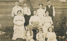
At Union Street
https://search.heritageburnaby.ca/link/archivedescription34886
- Repository
- City of Burnaby Archives
- Date
- 1911
- Collection/Fonds
- Burnaby Historical Society fonds
- Description Level
- Item
- Physical Description
- 1 photograph : sepia postcard ; 8.5 x 13.8 cm
- Scope and Content
- Photographic postcard of a group of men, women and children outside at 4900 Union Street. Identified on the back of the postcard: Tom Simms, Municipal worker, upper right corner; and, Mirium Beckman, girl in lower right corner.
- Repository
- City of Burnaby Archives
- Date
- 1911
- Collection/Fonds
- Burnaby Historical Society fonds
- Subseries
- Olive Cullum subseries
- Physical Description
- 1 photograph : sepia postcard ; 8.5 x 13.8 cm
- Description Level
- Item
- Record No.
- 154-002
- Access Restriction
- No restrictions
- Reproduction Restriction
- No known restrictions
- Accession Number
- BHS1985-27
- Scope and Content
- Photographic postcard of a group of men, women and children outside at 4900 Union Street. Identified on the back of the postcard: Tom Simms, Municipal worker, upper right corner; and, Mirium Beckman, girl in lower right corner.
- Names
- Beckman, Mirium
- Simms, Tom
- Media Type
- Photograph
- Notes
- Title based on contents of photograph
- Geographic Access
- Union Street
- Street Address
- 4900 Union Street
- Planning Study Area
- Brentwood Area
Images


Ink
https://search.heritageburnaby.ca/link/museumartifact90812
- Repository
- Burnaby Village Museum
- Accession Code
- BV020.40.3
- Description
- Glass bottle of black ink, with a plastic textured lid. The front label is yellow with a gold border, and a blue band along the bottom of the label. It has a black ink stain down the front. The back label is smaller and lighter colour with a yellow stain that reaches to the middle of the label.
- Object History
- This ink came along with a lettering guide used in the City of Burnaby's Planning Department, in the late 1950s. See also BV020.40.2
- Classification
- Written Communication T&E - - Writing Accessories
- Object Term
- Ink
- Marks/Labels
- Chin-Chin waterproof Liquid PearlInk / Sole Canadian Distributors / Made in Germany / Protect from Freezing
- Colour
- Black
- Yellow
- Blue
- Measurements
- 30cm high
- Maker
- PearlInk
- Subjects
- Documentary Artifacts - Architectural Drawings
- Government - Local Government
- Land - Land Surveying
- Occupations - Civic Workers
- Planning - City Planning
- Historic Neighbourhood
- Burnaby Lake (Historic Neighbourhood)
- Planning Study Area
- Douglas-Gilpin Area
Images


Lettering Guide
https://search.heritageburnaby.ca/link/museumartifact90811
- Repository
- Burnaby Village Museum
- Accession Code
- BV020.40.2
- Description
- Wooden box with a hinged lid and base with slats for rules and holes for lettering tips. The box contains lettering materials, including white rulers,ink pens in green cardboard cylindrical tubes, guiding stencils for lettering in different fonts, metal tool to hold ink nibs.
- Object History
- This lettering guide was used in the City of Burnaby's Planning Department, in the late 1950s. A lettering guide template is a special type of template used to write uniform characters. It consists of a sheet of plastic or other material with cut-outs of letters, numbers, and other shapes used especially for creating technical drawings. For decades they have been essential for lettering a drawing nameplate so text and other designs could be made quickly and uniformly. Although they have been superseded by the use of computers, during the greater part of the last century they were used to relatively ease the lettering process in the creation of technical drawings. They were an indispensable tool for architects and technical illustrators.
- Classification
- Written Communication T&E - - Writing Devices
- Object Term
- Guide, Lettering
- Marks/Labels
- WRICO LETTERING PEN
- Maker
- WRICO
- Subjects
- Construction Tools and Equipment
- Documentary Artifacts - Architectural Drawings
- Government - Local Government
- Land - Land Surveying
- Occupations - Civic Workers
- Historic Neighbourhood
- Burnaby Lake (Historic Neighbourhood)
- Planning Study Area
- Douglas-Gilpin Area
Images

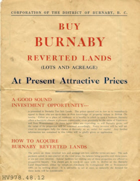
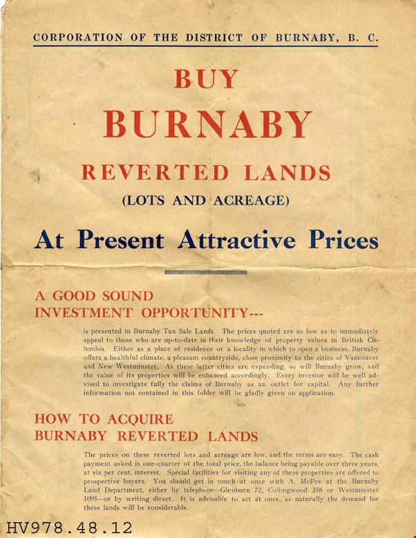
leaflet
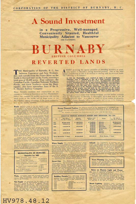
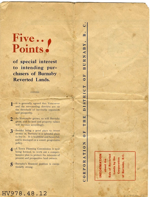
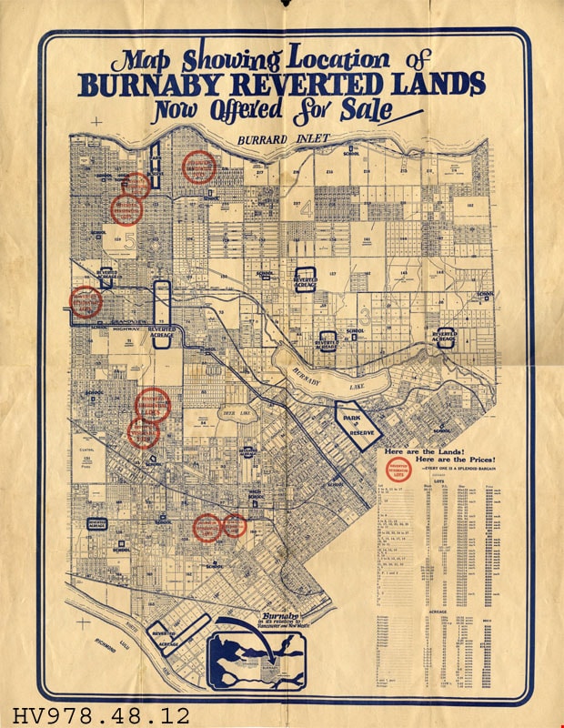
https://search.heritageburnaby.ca/link/museumartifact18096
- Repository
- Burnaby Village Museum
- Accession Code
- HV978.48.12
- Description
- Buy Burnaby Reverted Lands - Leaflet -- [192-]. Advertising leaflet for Burnaby Reverted Lands produced by the Corporation of the District of Burnaby B.C.. The leaflet explains the attraction to Burnaby and the good investment opportunity that it provides. It provides statistics from 1925 as to the financial position and property taxes. There is also a map outlining the land available for purchase.
- Subjects
- Documentary Artifacts
- Documentary Artifacts - Leaflets
- Documentary Artifacts - Maps
- Advertising Medium
- Advertising Medium - Flyer
Images


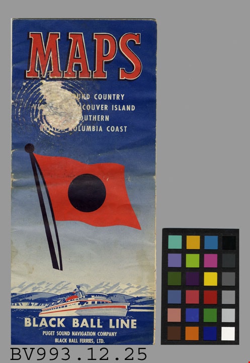
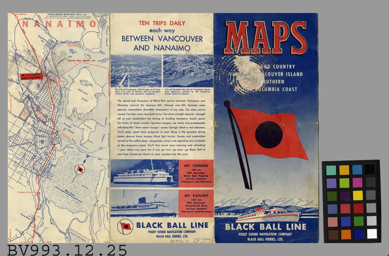
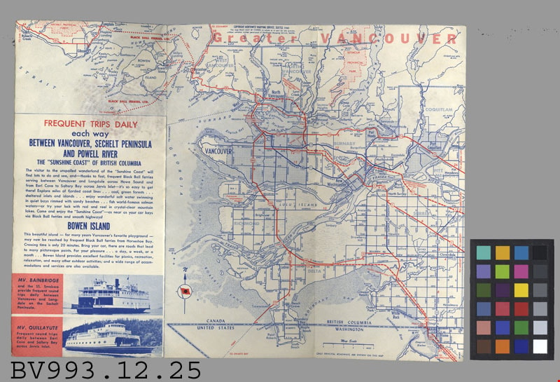
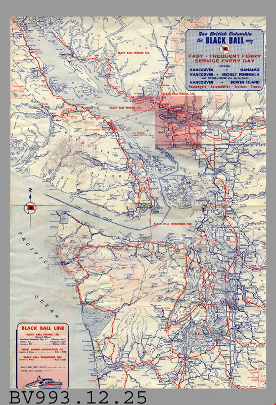
map
https://search.heritageburnaby.ca/link/museumartifact35811
- Repository
- Burnaby Village Museum
- Accession Code
- BV993.12.25
- Description
- Black Ball Line - Leaflet -- [1961]. Map leaflet for the Black Ball Line operated by Puget Sound Navigation Company and Black Ball Ferries Limited. The leaflet provides maps and information about the various trips that the company makes. The main routes appear to be between Vancouver and Nanaimo, Sechelt Peninsula, Powell River and Bowen Island. The leaflet measures 10cm x 23cm when closed.
- Title
- Maps
- Subjects
- Documentary Artifacts
- Documentary Artifacts - Leaflets
- Documentary Artifacts - Maps
- Transportation
- Transportation - Ferries
Images
![School room at Oakalla, [195-] (date of original), copied 1991 thumbnail](/media/hpo/_Data/_Archives_Images/_Unrestricted/370/370-733.jpg?width=280)
School room at Oakalla
https://search.heritageburnaby.ca/link/archivedescription38146
- Repository
- City of Burnaby Archives
- Date
- [195-] (date of original), copied 1991
- Collection/Fonds
- Burnaby Historical Society fonds
- Description Level
- Item
- Physical Description
- 1 photograph : b&w ; 3.6 x 4.4 cm print on contact sheet 20.6 x 26.8 cm
- Scope and Content
- Photograph of the interior of a school room at Oakalla Prison Farm. Men are seated at desks, and a student and teacher are at the blackboard standing beside a map. A list of words is on the blackboard.
- Repository
- City of Burnaby Archives
- Date
- [195-] (date of original), copied 1991
- Collection/Fonds
- Burnaby Historical Society fonds
- Subseries
- Burnaby Image Bank subseries
- Physical Description
- 1 photograph : b&w ; 3.6 x 4.4 cm print on contact sheet 20.6 x 26.8 cm
- Description Level
- Item
- Record No.
- 370-733
- Access Restriction
- No restrictions
- Reproduction Restriction
- Reproduce for fair dealing purposes only
- Accession Number
- BHS1999-03
- Scope and Content
- Photograph of the interior of a school room at Oakalla Prison Farm. Men are seated at desks, and a student and teacher are at the blackboard standing beside a map. A list of words is on the blackboard.
- Subjects
- Documentary Artifacts - Maps
- Buildings - Public - Detention Facilities
- Buildings - Schools
- Occupations - Teachers
- Names
- Oakalla Prison Farm
- Media Type
- Photograph
- Notes
- Title based on contents of photograph
- 1 b&w copy negative accompanying
- Negative has a pink cast
- Geographic Access
- Oakmount Crescent
- Street Address
- 5220 Oakmount Crescent
- Historic Neighbourhood
- Burnaby Lake (Historic Neighbourhood)
- Planning Study Area
- Oakalla Area
Images
![School room at Oakalla, [195-] (date of original), copied 1991 thumbnail](/media/hpo/_Data/_Archives_Images/_Unrestricted/370/370-733.jpg)
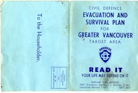
map
https://search.heritageburnaby.ca/link/museumartifact83653
- Repository
- Burnaby Village Museum
- Accession Code
- BV007.34.1
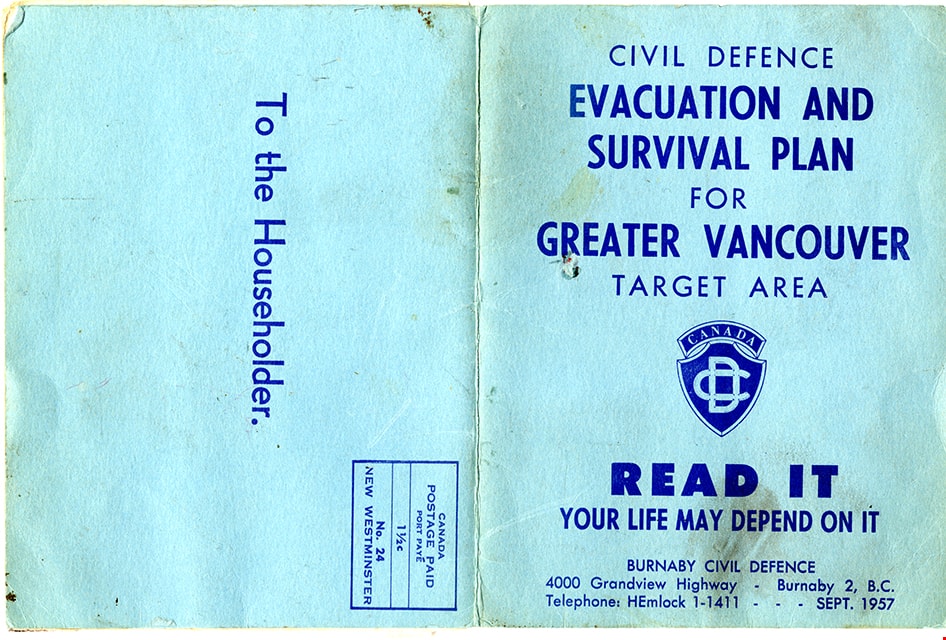
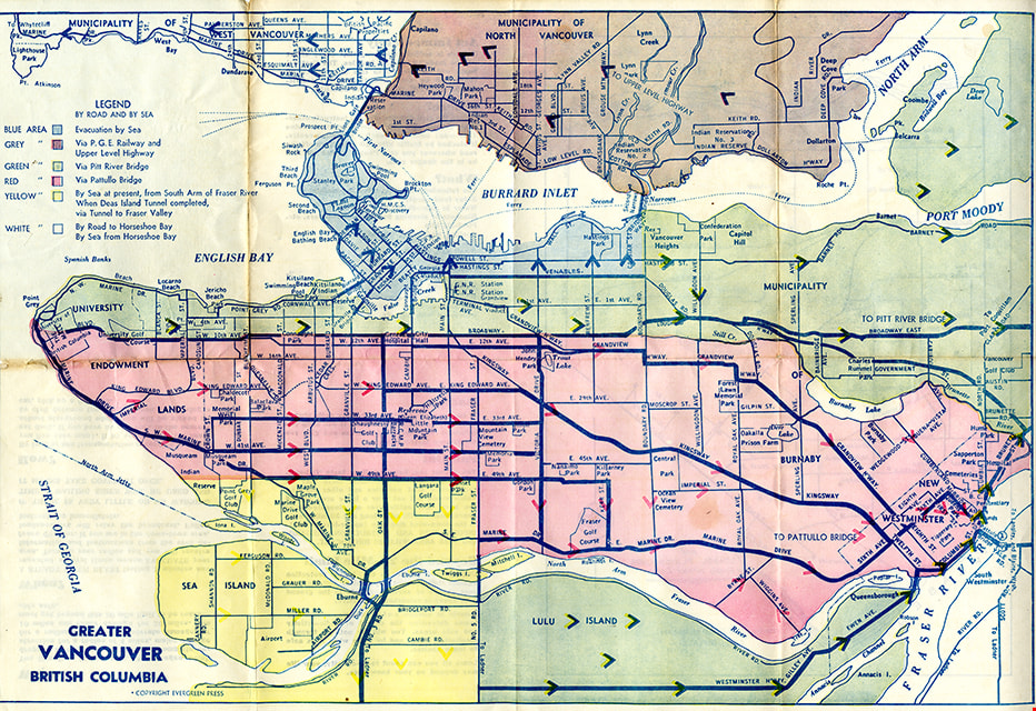
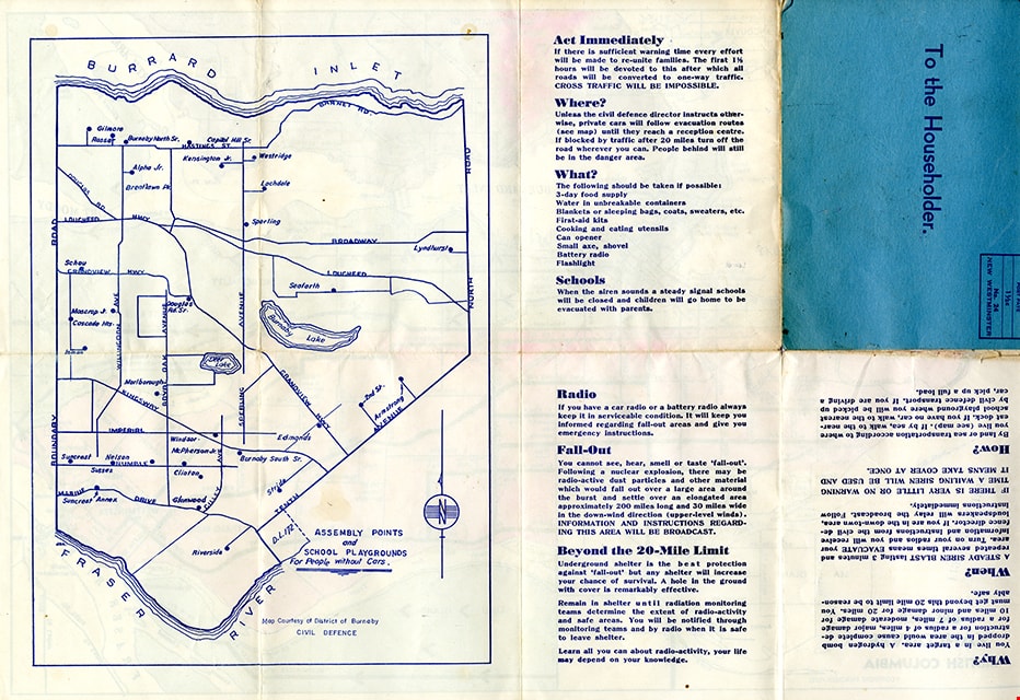
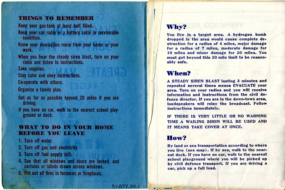
- Description
- Folded col. map within blue cover; printed both sides; Civil Defence Evacuation and Survival Plan - Map -- [1957] produced by Burnaby Civil Defence; title on front cover reads "CIVIL DEFENCE / EVACUATION AND SURVIVAL PLAN /FOR / GREATER VANCOUVER / TARGET AREA / READ IT / YOUR LIFE MAY DEPEND ON IT". Colour map inside is titled "GREATER / VANCOUVER / BRITISH COLUMBIA" and includes a legend with various evacuation routes by road and by sea; copyright Evergreen Press. Verso of map includes a map of Burnaby courtesy of District of Burnaby Civil Defence titled "ASSEMBLY POINTS / and / SCHOOL PLAYGROUNDS / for People without Cars" and detailed information about things to remember during an emergency evacuation.
- Object History
- Map was made available to citizens of Burnaby and was produced by Burnaby Civil Defence, 4000 Grandview Highway, Burnaby B.C.
- Category
- 08. Communication Artifacts
- Classification
- Documentary Artifacts - - Graphic Documents
- Object Term
- Cartograph, Map
- Colour
- Blue
- Measurements
- 30.5 x 34 cm folded to 15 x 11.5 cm
- Maker
- Evergreen Press Limited
- Country Made
- Canada
- Province Made
- British Columbia
- Publication Date
- Sept. 1957
- Names
- Burnaby Civil Defence
Images
map
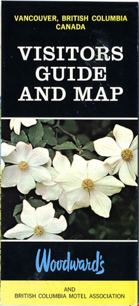
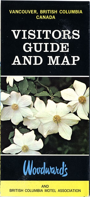
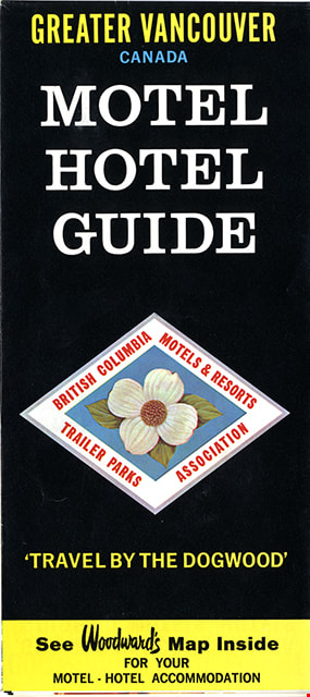
https://search.heritageburnaby.ca/link/museumartifact91126
- Repository
- Burnaby Village Museum
- Accession Code
- BV011.44.10
- Description
- map brochure; cover on one side reads "VANCOUVER, BRITISH COLUMBIA / CANADA / VISITORS / GUIDE / AND MAP" and the other side reads: "GREATER VANCOUVER / CANADA / MOTEL / HOTEL / GUIDE / TRAVEL BY THE DOGOOD'" and includes the logo for "British Columbia / Motels & Resorts / Trailer Parks / Association" with dogwood in centre. One side of fold-out includes map titled "Guide Map of Greater Vancouver / Woodwards" and includes inset map of Downtown Vancouver and Stanley Park and inset map of Lower Mainland and Fraser Valley Vancouver and Vicinity along with a list of Greater Vanouver Area Motels and Hotels. The other side of the fold-out includes colour adds for tourist sites and amenities in Greater Vancouver including Capilano Suspension bridge; Heritage Village, Burnaby, B.C.; MacMillan Planetarium; Bloedel Conservatory; Grouse Mountain; Gastown; The Ship of the Seven Seas restaurant and Woodwards stores and shopping centres. Map was published in the public interest by Woodward's (Lower Mainland) department stores; B.C. Motels and Resorts Association Branch "C" whose members appear on the map inside.
- Category
- 08. Communication Artifacts
- Classification
- Documentary Artifacts - - Graphic Documents
- Object Term
- Cartograph, Map
- Measurements
- 45.5 x 70 cm folded to 22.5 x 10 cm
- Country Made
- Canada
- Geographic Access
- Vancouver
Images
newsletter
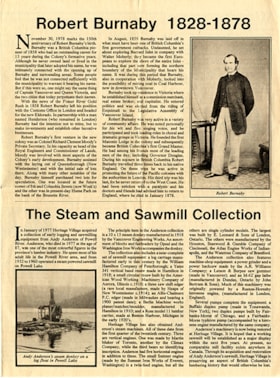
https://search.heritageburnaby.ca/link/museumartifact84683
- Repository
- Burnaby Village Museum
- Accession Code
- BV011.55.1
- Description
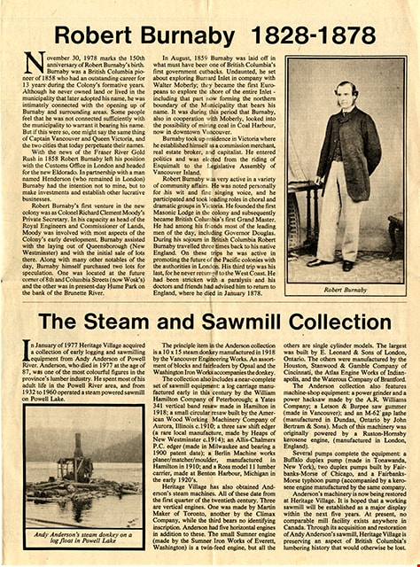
- Newsletter; created by Heritage Village Museum [1978]. Printed on newsprint, double sided, folded in centre. Newsletter also served as a map and guide of the village. The front page of the newsletter features articles "Robert Burnaby 1828 - 1878" and "The Steam and Sawmill Collection". The centre two pages open to a list of exhibits in the village with a site map. The back page includes "Operating Times"; "Heritage Village Calendar", and "Application for Membership" of the Century park Museum Association. Design and production by Dave Lovell.
- Object History
- Newsletter created by Heritage Village Museum (Burnaby Village Museum) and given out free to visitors. Design and production of the newsletter was created by Dave Lovell.
- Category
- 08. Communication Artifacts
- Classification
- Documentary Artifacts - - Other Documents
- Object Term
- Serial
- Colour
- Beige
- Measurements
- Height: 30 cm x Width: 44 cm folded to Height: 30 cm x Width: 22 cm
- Maker
- Heritage Village
- Country Made
- Canada
- Province Made
- British Columbia
- Site/City Made
- Burnaby
- Publication Date
- [1978]
Images
Documents
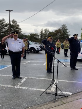
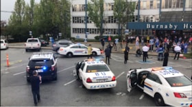
RCMP officers saluting with firefighters
https://search.heritageburnaby.ca/link/museumdescription14750
- Repository
- Burnaby Village Museum
- Date
- 12 May 2020
- Collection/Fonds
- Burnaby Village Museum COVID-19 collection
- Description Level
- Item
- Physical Description
- 1 photograph (jpg) : col. ; 144 dpi.
- Scope and Content
- Photograph of three RCMP officers and firefighter in the parking lot of Burnaby General Hospital. The three RCMP officers are saluting to healthcare workers.
- Repository
- Burnaby Village Museum
- Collection/Fonds
- Burnaby Village Museum COVID-19 collection
- Description Level
- Item
- Physical Description
- 1 photograph (jpg) : col. ; 144 dpi.
- Scope and Content
- Photograph of three RCMP officers and firefighter in the parking lot of Burnaby General Hospital. The three RCMP officers are saluting to healthcare workers.
- History
- Photograph was taken by Richard Liu on May 12, 2020 around 7:00pm. Richard helped organize a 'stick-tap' to salute front line health care workers at the Burnaby Hospital. The Vancouer Canuck's mascot "Fin", Mayor of Burnaby Mike Hurley, MLA Anne Kang and MLA Katrina Chen, MP Peter Juilan, the RCMP Chief, the Fire Chief and Transit Police Chief were in attendance. These 'salutes' to health care workers were common in April and May during the earliest and most uncertain months of the COVID-19 pandemic. Many local neighbourhoods across Burnaby, the Lower Mainland and the Province began regularly gathering at 7:00pm to bang pots and pans, honk horns, and generally celebrate and acknowledge the work of health care professionals. The presence of "Fin" was added because the Vancouver Canuck and NHL were not playing, so Fin was available to make the rounds. His visits were often surprises. Fin played the Canucks goal horn through the Fin Mobile roof speakers, with green and blue flashing lights. Fin visited six hospitals, as well as Canuck Place Children’s Hospice.
- Subjects
- Buildings - Civic - Hospitals
- Occupations - Civic Workers
- Occupations - Fire Fighters
- Occupations - Police Officers
- Occupations - Nurses
- Occupations - Physicians
- Pandemics - COVID-19
- Geographic Access
- Ingleton Avenue
- Street Address
- 3880 Ingleton Avenue
- Accession Code
- BV020.18.1
- Access Restriction
- No restrictions
- Reproduction Restriction
- No known restrictions
- Date
- 12 May 2020
- Media Type
- Photograph
- Historic Neighbourhood
- Broadview (Historic Neighbourhood)
- Planning Study Area
- Cascade-Schou Area
- Photographer
- Liu, Richard
- Notes
- Title based on contents of photograph
Images

Stick tap salute at Burnaby General Hospital
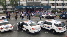
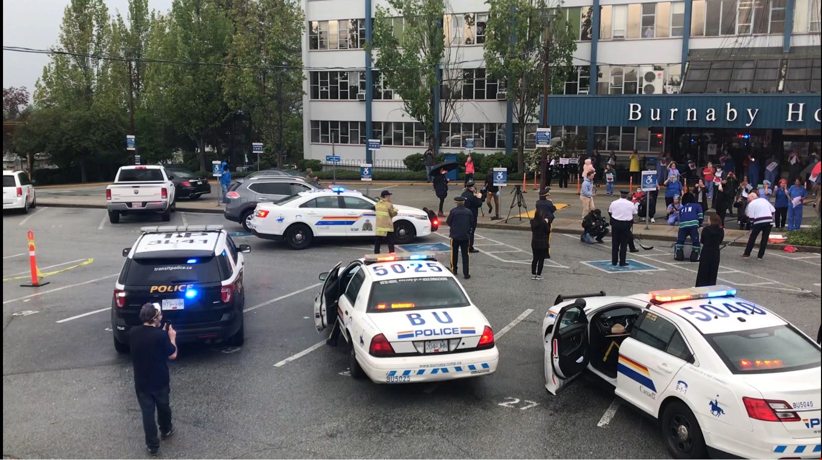
https://search.heritageburnaby.ca/link/museumdescription14751
- Repository
- Burnaby Village Museum
- Date
- 12 May 2020
- Collection/Fonds
- Burnaby Village Museum COVID-19 collection
- Description Level
- Item
- Physical Description
- 1 photograph (tiff) : col. ; 72 dpi.
- Scope and Content
- Photograph of Burnaby General Hospital with RCMP cars, RCMP officers and healthcare workers out in front. Burnaby Mayor Mike Hurley, Vancouver Canucks' mascot "Fin", Richard Liu and another man are dressed in Vancouver Canucks hockey jerseys and are standing near the front of the hospital holding h…
- Repository
- Burnaby Village Museum
- Collection/Fonds
- Burnaby Village Museum COVID-19 collection
- Description Level
- Item
- Physical Description
- 1 photograph (tiff) : col. ; 72 dpi.
- Scope and Content
- Photograph of Burnaby General Hospital with RCMP cars, RCMP officers and healthcare workers out in front. Burnaby Mayor Mike Hurley, Vancouver Canucks' mascot "Fin", Richard Liu and another man are dressed in Vancouver Canucks hockey jerseys and are standing near the front of the hospital holding hockey sticks. They are giving a stick tap salute in appreciation to the healthcare workers.
- History
- Photograph was taken by Richard Liu on May 12, 2020 around 7:00pm. Richard helped organize a 'stick-tap' to salute front line health care workers at the Burnaby Hospital. The Vancouer Canuck's mascot "Fin", Mayor of Burnaby Mike Hurley, MLA Anne Kang and MLA Katrina Chen, MP Peter Juilan, the RCMP Chief, the Fire Chief and Transit Police Chief were in attendance. These 'salutes' to health care workers were common in April and May during the earliest and most uncertain months of the COVID-19 pandemic. Many local neighbourhoods across Burnaby, the Lower Mainland and the Province began regularly gathering at 7:00pm to bang pots and pans, honk horns, and generally celebrate and acknowledge the work of health care professionals. The presence of "Fin" was added because the Vancouver Canuck and NHL were not playing, so Fin was available to make the rounds. His visits were often surprises. Fin played the Canucks goal horn through the Fin Mobile roof speakers, with green and blue flashing lights. Fin visited six hospitals, as well as Canuck Place Children’s Hospice.
- Subjects
- Buildings - Civic - Hospitals
- Occupations - Civic Workers
- Occupations - Fire Fighters
- Occupations - Police Officers
- Occupations - Nurses
- Occupations - Physicians
- Public Services - Health Services
- Pandemics - COVID-19
- Names
- Royal Canadian Mounted Police
- Burnaby Fire Department
- Burnaby General Hospital
- Hurley, Mike
- Liu, Richard N.
- Vancouver Canucks
- Geographic Access
- Ingleton Avenue
- Street Address
- 3880 Ingleton Avenue
- Accession Code
- BV020.18.2
- Access Restriction
- No restrictions
- Reproduction Restriction
- No known restrictions
- Date
- 12 May 2020
- Media Type
- Photograph
- Historic Neighbourhood
- Broadview (Historic Neighbourhood)
- Planning Study Area
- Cascade-Schou Area
- Photographer
- Liu, Richard N.
- Notes
- Title based on contents of photograph
Images

Stick tap salute at Burnaby General Hospital
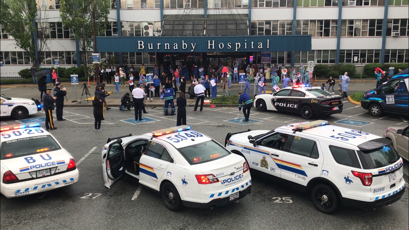
https://search.heritageburnaby.ca/link/museumdescription14752
- Repository
- Burnaby Village Museum
- Date
- 12 May 2020
- Collection/Fonds
- Burnaby Village Museum COVID-19 collection
- Description Level
- Item
- Physical Description
- 1 photograph (jpg) : col. ; 144 dpi.
- Scope and Content
- Photograph of Burnaby Mayor, Mike Hurley (left), "Fin" the Vancouver Canucks' mascot and Richard Liu (right) with hockey sticks. The three are gathered in the parking lot outside of Burnaby General Hospital in a stick tap salute of appreciation to the healthcare workers. Mike Hurley is dressed in a…
- Repository
- Burnaby Village Museum
- Collection/Fonds
- Burnaby Village Museum COVID-19 collection
- Description Level
- Item
- Physical Description
- 1 photograph (jpg) : col. ; 144 dpi.
- Scope and Content
- Photograph of Burnaby Mayor, Mike Hurley (left), "Fin" the Vancouver Canucks' mascot and Richard Liu (right) with hockey sticks. The three are gathered in the parking lot outside of Burnaby General Hospital in a stick tap salute of appreciation to the healthcare workers. Mike Hurley is dressed in a Vancouver Canucks hockey jersey. Members of the Burnaby RCMP and Burnaby Fire Department are standing in the background along with police cars and a fire truck.
- History
- Photograph was taken by Richard Liu on May 12, 2020 around 7:00pm. Richard helped organize a 'stick-tap' to salute front line health care workers at the Burnaby Hospital. The Vancouer Canuck's mascot "Fin", Mayor of Burnaby Mike Hurley, MLA Anne Kang and MLA Katrina Chen, MP Peter Juilan, the RCMP Chief, the Fire Chief and Transit Police Chief were in attendance. These 'salutes' to health care workers were common in April and May during the earliest and most uncertain months of the COVID-19 pandemic. Many local neighbourhoods across Burnaby, the Lower Mainland and the Province began regularly gathering at 7:00pm to bang pots and pans, honk horns, and generally celebrate and acknowledge the work of health care professionals. The presence of "Fin" was added because the Vancouver Canuck and NHL were not playing, so Fin was available to make the rounds. His visits were often surprises. Fin played the Canucks goal horn through the Fin Mobile roof speakers, with green and blue flashing lights. Fin visited six hospitals, as well as Canuck Place Children’s Hospice.
- Subjects
- Buildings - Civic - Hospitals
- Occupations - Civic Workers
- Occupations - Fire Fighters
- Occupations - Police Officers
- Occupations - Nurses
- Occupations - Physicians
- Pandemics - COVID-19
- Names
- Royal Canadian Mounted Police
- Burnaby Fire Department
- Burnaby General Hospital
- Hurley, Mike
- Liu, Richard N.
- Vancouver Canucks
- Geographic Access
- Ingleton Avenue
- Street Address
- 3880 Ingleton Avenue
- Accession Code
- BV020.18.3
- Access Restriction
- No restrictions
- Reproduction Restriction
- No known restrictions
- Date
- 12 May 2020
- Media Type
- Photograph
- Historic Neighbourhood
- Broadview (Historic Neighbourhood)
- Planning Study Area
- Cascade-Schou Area
- Photographer
- Liu, Richard N.
- Notes
- Title based on contents of photograph
Images

Stick tap salute to healthcare workers at Burnaby General Hospital
https://search.heritageburnaby.ca/link/museumdescription14755
- Repository
- Burnaby Village Museum
- Date
- 12 May 2020
- Collection/Fonds
- Burnaby Village Museum COVID-19 collection
- Description Level
- Item
- Physical Description
- 1 video recording (mp4) (00 min., 7 sec.) : digital, 30 fps, col., sd., stereo
- Scope and Content
- Item consists of a short film clip created by Richard Liu documenting the 'stick-tap" salute to front line healthcare workers outside of Burnaby General Hospital. Members of the Burnaby RCMP, Burnaby Fire Department and healthcare workers have gathered for the event. Mayor Mike Hurley, the Vancouve…
- Repository
- Burnaby Village Museum
- Collection/Fonds
- Burnaby Village Museum COVID-19 collection
- Description Level
- Item
- Physical Description
- 1 video recording (mp4) (00 min., 7 sec.) : digital, 30 fps, col., sd., stereo
- Scope and Content
- Item consists of a short film clip created by Richard Liu documenting the 'stick-tap" salute to front line healthcare workers outside of Burnaby General Hospital. Members of the Burnaby RCMP, Burnaby Fire Department and healthcare workers have gathered for the event. Mayor Mike Hurley, the Vancouver Canucks' mascot "Fin" and two other men are tapping hockey sticks on the ground. A row of Burnaby RCMP police cars are parked in the parking lot. Fire truck and police car sirens are audible during the event.
- History
- This event was recorded by Richard Liu on May 12, 2020 around 7:00pm. Richard helped organize a 'stick-tap' to salute front line health care workers at the Burnaby Hospital. The Vancouer Canuck's mascot "Fin", Mayor of Burnaby Mike Hurley, MLA Anne Kang and MLA Katrina Chen, MP Peter Juilan, the RCMP Chief, the Fire Chief and Transit Police Chief were in attendance. These 'salutes' to health care workers were common in April and May during the earliest and most uncertain months of the COVID-19 pandemic. Many local neighbourhoods across Burnaby, the Lower Mainland and the Province began regularly gathering at 7:00pm to bang pots and pans, honk horns, and generally celebrate and acknowledge the work of health care professionals. The presence of "Fin" was added because the Vancouver Canuck and NHL were not playing, so Fin was available to make the rounds. His visits were often surprises. Fin played the Canucks goal horn through the Fin Mobile roof speakers, with green and blue flashing lights. Fin visited six hospitals, as well as Canuck Place Children’s Hospice.
- Creator
- Liu, Richard
- Subjects
- Buildings - Civic - Hospitals
- Occupations - Civic Workers
- Occupations - Fire Fighters
- Occupations - Police Officers
- Occupations - Nurses
- Occupations - Physicians
- Pandemics - COVID-19
- Names
- Royal Canadian Mounted Police
- Burnaby Fire Department
- Burnaby General Hospital
- Hurley, Mike
- Liu, Richard N.
- Vancouver Canucks
- Geographic Access
- Ingleton Avenue
- Street Address
- 3880 Ingleton Avenue
- Accession Code
- BV020.18.6
- Access Restriction
- No restrictions
- Reproduction Restriction
- No known restrictions
- Date
- 12 May 2020
- Media Type
- Moving Images
- Historic Neighbourhood
- Broadview (Historic Neighbourhood)
- Planning Study Area
- Cascade-Schou Area
- Photographer
- Liu, Richard N.
- Notes
- Title based on contents of film
Images
Video
Stick tap salute to healthcare workers at Burnaby General Hospital, 12 May 2020
Stick tap salute to healthcare workers at Burnaby General Hospital, 12 May 2020
https://search.heritageburnaby.ca/media/hpo/_Data/_BVM_Moving_Images/2020_0018_0006_001.m4v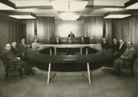
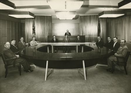
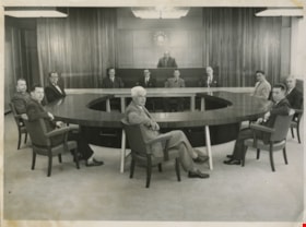
Burnaby Council Members, 1960
https://search.heritageburnaby.ca/link/archivedescription34698
- Repository
- City of Burnaby Archives
- Date
- 1960
- Collection/Fonds
- Burnaby Historical Society fonds
- Description Level
- Item
- Physical Description
- 1 photograph : b&w ; 19.1 x 25.3 cm
- Scope and Content
- Photograph of Burnaby Municipal Council and staff seated in the Council Chambers at the Municipal Hall, 4949 Canada Way. Councillors, anti-clockwise starting at upper left: Camille Mather, Malcolm J. Harper, John D. Drummond, Charles W. MacSorley, Donald H. Jamieson, Russell E. Hicks, James H. Edwa…
- Repository
- City of Burnaby Archives
- Date
- 1960
- Collection/Fonds
- Burnaby Historical Society fonds
- Subseries
- Photographs subseries
- Physical Description
- 1 photograph : b&w ; 19.1 x 25.3 cm
- Description Level
- Item
- Record No.
- 103-001
- Access Restriction
- No restrictions
- Reproduction Restriction
- Reproduce for fair dealing purposes only
- Accession Number
- BHS2007-04
- Scope and Content
- Photograph of Burnaby Municipal Council and staff seated in the Council Chambers at the Municipal Hall, 4949 Canada Way. Councillors, anti-clockwise starting at upper left: Camille Mather, Malcolm J. Harper, John D. Drummond, Charles W. MacSorley, Donald H. Jamieson, Russell E. Hicks, James H. Edwards, and Robert W. Prittie. Staff, seated at table at back, left to right: J.H. Shaw (Clerk), H.W. Balfour (Manager), and S.B. McCafferty (Treasurer). Reeve Alan H. Emmott is seated on the dias.
- Subjects
- Officials - Alderman and Councillors
- Buildings - Civic - City Halls
- Officials - Mayors and Reeves
- Occupations - Civic Workers
- Occupations - City Clerks
- Names
- Balfour, H.W.
- Drummond, John D. "Doug"
- Edwards, James H.
- Emmott, Alan H.
- Harper, Malcolm J.
- Hicks, Russell E.
- Jamieson, Donald H
- MacSorley, Charles W.
- Mather, Camille
- McCafferty, S.B. "Bart"
- Prittie, Robert W. "Bob"
- Shaw, John Horace "Jack"
- Burnaby City Hall
- Media Type
- Photograph
- Photographer
- LeBlanc, Don
- Notes
- Annotation at bottom of photograph reads, "Burnaby Council Members - 1960"
- Stamp and annotation on back of photograph reads, "Croton Studio / Don Leblanc / Middlegate Shopping Centre, 406-7155 Kingsway, South Burnaby B.C. / Lakeview 2-2848 / File Number: 1114, Negative Number: 2"
- Geographic Access
- Canada Way
- Street Address
- 4949 Canada Way
- Historic Neighbourhood
- Burnaby Lake (Historic Neighbourhood)
- Planning Study Area
- Douglas-Gilpin Area
Images
Municipal Council
https://search.heritageburnaby.ca/link/archivedescription55631
- Repository
- City of Burnaby Archives
- Date
- 1956
- Collection/Fonds
- Charles MacSorley fonds
- Description Level
- Item
- Physical Description
- 1 photograph : b&w ; 20.5 x 25.5 cm
- Scope and Content
- Photograph of the 1956 Burnaby Municipal Council in Council Chambers at Burnaby Municipal Hall. Identified in the photograph are (starting at centre, forefront and moving clockwise): Gerald Charlton, Fred Philps, Wesley Morrison, Arnold Hean, Ted Ward (Deputy Municipal Clerk), John Shaw (Municipal…
- Repository
- City of Burnaby Archives
- Date
- 1956
- Collection/Fonds
- Charles MacSorley fonds
- Physical Description
- 1 photograph : b&w ; 20.5 x 25.5 cm
- Description Level
- Item
- Record No.
- 486-025
- Access Restriction
- No restrictions
- Reproduction Restriction
- Reproduce for fair dealing purposes only
- Accession Number
- 2005-14
- Scope and Content
- Photograph of the 1956 Burnaby Municipal Council in Council Chambers at Burnaby Municipal Hall. Identified in the photograph are (starting at centre, forefront and moving clockwise): Gerald Charlton, Fred Philps, Wesley Morrison, Arnold Hean, Ted Ward (Deputy Municipal Clerk), John Shaw (Municipal Clerk), Reeve Charles MacSorley (in the back), two unkown members of staff, Samuel Hughes, William Philps and Doug Drummond.
- Subjects
- Officials - Alderman and Councillors
- Officials - Mayors and Reeves
- Buildings - Civic - City Halls
- Occupations - City Clerks
- Occupations - Civic Workers
- Names
- Charlton, Gerald
- Philps, Fred
- Morrison, Wesley
- Hean, Arnold F.C.
- Ward, Ted
- Shaw, John Horace "Jack"
- MacSorley, Charles W.
- Hughes, Samuel E.
- Philps, William P.
- Drummond, John D. "Doug"
- Media Type
- Photograph
- Photographer
- Cunningham, W.
- Notes
- Title based on contents of photograph
- Photographer's stamp on verso
- Notes on verso identify the people in the photograph
- Geographic Access
- Canada Way
- Street Address
- 4949 Canada Way
- Historic Neighbourhood
- Burnaby Lake (Historic Neighbourhood)
- Planning Study Area
- Douglas-Gilpin Area
Images

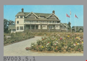
postcard
https://search.heritageburnaby.ca/link/museumartifact45258
- Repository
- Burnaby Village Museum
- Accession Code
- BV003.5.1
- Description
- Postcard: colour photo of large house in garden, flagpoles; horizontal; on reverse in navy, "No. 5" "CENTURY GARDENS" "Burnaby, B.C., Canada" "Century Gardens was Burnaby's Centennial Project... Canada's 100th birthday... north shore of Deer Lake... Burnaby's new Art Centre...", the restored heritage house "Fairacres", later "Burnaby Art Gallery"; illustration at left of R.C.M.P. officer; at bottom, "Photo by George Allen Aerial Photos Ltd." "S-2796"; navy bar up centre "NATURAL COLOR PRODUCTIONS, LTD., VANCOUVER, B.C."; at bottom, "MADE IN CANADA" "GRANT-MANN" and logo; at upper right, illustration of mounted R.C.M.P. officer, "POST CARD" "ADDRESS", rectangle "USE CANADIAN POSTAGE"; unused
- Object History
- Purchased on E-Bay.
- Classification
- Written Communication T&E - - Writing Media
- Object Term
- Postcard
- Country Made
- Canada
- Province Made
- British Columbia
- Site/City Made
- Vancouver
- Title
- Century Gardens Burnaby, B.C., Canada S-2796
- Subjects
- Documentary Artifacts
- Documentary Artifacts - Postcards
- Documentary Artifacts - Photographs
- Buildings
- Buildings - Civic
- Buildings - Civic - Art Galleries
- Names
- Burnaby Art Gallery
Images

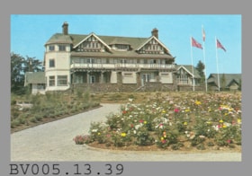
postcard
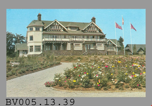
https://search.heritageburnaby.ca/link/museumartifact48256
- Repository
- Burnaby Village Museum
- Accession Code
- BV005.13.39
- Description
- Postcard: colour photo of large house in garden, flagpoles; horizontal; on reverse in navy, "No. 5" "CENTURY GARDENS" "Burnaby, B.C., Canada" "Century Gardens was Burnaby's Centennial Project... Canada's 100th birthday... north shore of Deer Lake... Burnaby's new Art Centre...", the restored heritage house "Fairacres", later "Burnaby Art Gallery"; illustration at left of R.C.M.P. officer; at bottom, "Photo by George Allen Aerial Photos Ltd." "S-2796"; navy bar up centre "NATURAL COLOR PRODUCTIONS, LTD., VANCOUVER, B.C."; at bottom, "MADE IN CANADA" "GRANT-MANN" and logo; at upper right, illustration of mounted R.C.M.P. officer, "POST CARD" "ADDRESS", rectangle "USE CANADIAN POSTAGE"; unused
- Classification
- Written Communication T&E - - Writing Media
- Object Term
- Postcard
- Marks/Labels
- No.5 / Century Gardens / Burnaby, B.C., Canada / ..Burnaby's Centennial Project Commemorating Canada's 100th Birthday..
- Country Made
- Canada
- Province Made
- British Columbia
- Site/City Made
- Vancouver
- Title
- Century Gardens Burnaby, B.C., Canada S-2796
- Subjects
- Documentary Artifacts
- Documentary Artifacts - Postcards
- Documentary Artifacts - Photographs
- Buildings
- Buildings - Civic
- Buildings - Civic - Art Galleries
- Names
- Burnaby Art Gallery
Images