More like 'Still Creek conservation ceremony'
Narrow Results By
Subject
- Accidents 1
- Accidents - Automobile Accidents 1
- Adornment 6
- Adornment - Lapel Pins 9
- Advertising Medium 9
- Advertising Medium - Signs and Signboards 42
- Aerial Photographs 24
- Agricultural Tools and Equipment 2
- Agricultural Tools and Equipment - Gardening Equipment 4
- Agricultural Tools and Equipment - Plows 2
- Agriculture 3
- Agriculture - Farms 12
![Burnaby creek conservationists, [2002] thumbnail](/media/hpo/_Data/_Archives_Images/_Unrestricted/535/535-1959-1.jpg?width=280)
Burnaby creek conservationists
https://search.heritageburnaby.ca/link/archivedescription96276
- Repository
- City of Burnaby Archives
- Date
- [2002]
- Collection/Fonds
- Burnaby NewsLeader photograph collection
- Description Level
- File
- Physical Description
- 4 photographs (tiff) : col.
- Scope and Content
- File contains photographs of volunteer conservationists with the Eagle Creek Streamkeepers, Byrne Creek Streamkeepers, and Sapperton Fish & Game Club at work in the Lake City area by Eagle Creek and the Brunette River. Photographs depict Nick Kvenich, of the Eagle Creek Streamkeepers, in a creek; m…
- Repository
- City of Burnaby Archives
- Date
- [2002]
- Collection/Fonds
- Burnaby NewsLeader photograph collection
- Physical Description
- 4 photographs (tiff) : col.
- Description Level
- File
- Record No.
- 535-1959
- Access Restriction
- No restrictions
- Reproduction Restriction
- No restrictions
- Accession Number
- 2018-12
- Scope and Content
- File contains photographs of volunteer conservationists with the Eagle Creek Streamkeepers, Byrne Creek Streamkeepers, and Sapperton Fish & Game Club at work in the Lake City area by Eagle Creek and the Brunette River. Photographs depict Nick Kvenich, of the Eagle Creek Streamkeepers, in a creek; members of the Byrne Creek Streamkeepers observing a storm drain; and Elmer Rudolf feeding fish at a Sapperton Fish & Game Club hatchery.
- Subjects
- Geographic Features - Creeks
- Geographic Features - Lakes and Ponds
- Geographic Features - Ravines
- Geographic Features - Streams
- Media Type
- Photograph
- Photographer
- Bartel, Mario
- Notes
- Title based on caption
- Collected by editorial for use in a March 2002 issue of the Burnaby NewsLeader
- Caption from metadata for 535-1959-1: "Nick Kvenich is one of the founding members of the Eagle Creek Streamkeepers, which is looking to preserve the habitat of the creek that runs down from Squint Lake into a ravine below the Lake City industrial area."
- Caption from metadata for 535-1959-2: "Joan Carne (r) and Louise Towell, of the Byrne Creek Streamkeepers, examine a storm drain in an industrial area above the creek. The habitat faces constant pressure from businesses and homeowners who pour solvents, soaps and substances into the drains without thought to the consequences."
- Caption from metadata for 535-1959-3: "Nick Kvenich, one of the founding members of the Eagle Creek Streamkeepers, climbs through a fallen tree that is blocking a trail that runs alongside the creek, in a ravine below the Lake City industrial area. Although the tree will eventually be cleared by the GVRD, Kvenich says he prefers if such obstacles be left alone, as they would discourage people who might abuse the habitat."
- Caption from metadata for 535-1959-4: "Elmer Rudolf feeds a new batch of coho fry at the Sapperton Fish & Game Club's hatchery, near the Brunette River. The fry are normally fed by a timed conveyor belt, but that is supplemented by hand feedings to give the weaker fish a chance."
- Geographic Access
- Brunette River
- Eagle Creek
- Planning Study Area
- Lake City Area
Images
![Burnaby creek conservationists, [2002] thumbnail](/media/hpo/_Data/_Archives_Images/_Unrestricted/535/535-1959-1.jpg)
![Byrne Creek Streamkeepers, [2001] thumbnail](/media/hpo/_Data/_Archives_Images/_Unrestricted/535/535-2194-1.jpg?width=280)
Byrne Creek Streamkeepers
https://search.heritageburnaby.ca/link/archivedescription96572
- Repository
- City of Burnaby Archives
- Date
- [2001]
- Collection/Fonds
- Burnaby NewsLeader photograph collection
- Description Level
- File
- Physical Description
- 2 photographs (tiff) : col.
- Scope and Content
- File contains members of the Byrne Creek Streamkeepers during their work to protect the waterways and salmon in the area. Photographs depict Bob Fuller checking a waterflow measuring gauge and Joan Carne standing in the overflow channel at the salmon rearing ponds below Marine Drive.
- Repository
- City of Burnaby Archives
- Date
- [2001]
- Collection/Fonds
- Burnaby NewsLeader photograph collection
- Physical Description
- 2 photographs (tiff) : col.
- Description Level
- File
- Record No.
- 535-2194
- Access Restriction
- No restrictions
- Reproduction Restriction
- No restrictions
- Accession Number
- 2018-12
- Scope and Content
- File contains members of the Byrne Creek Streamkeepers during their work to protect the waterways and salmon in the area. Photographs depict Bob Fuller checking a waterflow measuring gauge and Joan Carne standing in the overflow channel at the salmon rearing ponds below Marine Drive.
- Subjects
- Persons - Volunteers
- Geographic Features - Creeks
- Geographic Features - Lakes and Ponds
- Geographic Features - Streams
- Media Type
- Photograph
- Photographer
- Bartel, Mario
- Notes
- Title based on caption
- Collected by editorial for use in a March 2001 issue of the Burnaby NewsLeader
- Caption from metadata for 535-2194-1: "Bob Fuller, of the Byrne Creek Streamkeepers, checks the guage that measures the flow of water which is released from the holding pond below Marine Drive to the salmon spawning beds downstream."
- Caption from metadata for 535-2194-2: "Joan Carne of the Byrne Creek Streamkeepers stands in the overflow channel at the salmon rearing ponds below Marine Drive. Although last week's chemical spill into Byrne Creek didn't reach the ponds, Carne says it's a constant battle to educate people to take care of the area's creeks and streams."
- Geographic Access
- Marine Drive
- Byrne Creek
- Planning Study Area
- Stride Hill Area
Images
![Byrne Creek Streamkeepers, [2001] thumbnail](/media/hpo/_Data/_Archives_Images/_Unrestricted/535/535-2194-1.jpg)
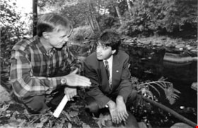
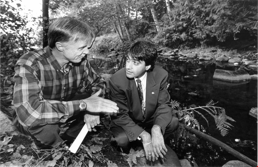
Mark Angelo with Moe Sihota
https://search.heritageburnaby.ca/link/archivedescription78558
- Repository
- City of Burnaby Archives
- Date
- October 1, 1995
- Collection/Fonds
- Burnaby NewsLeader photograph collection
- Description Level
- Item
- Physical Description
- 1 photograph : b&w ; 14.5 x 22.5 cm
- Scope and Content
- Photograph of Mark Angelo, chair of the BC Outdoor Recreation Council, with provincial Minister of Environment Moe Sihota near Deer Lake Creek.
- Repository
- City of Burnaby Archives
- Date
- October 1, 1995
- Collection/Fonds
- Burnaby NewsLeader photograph collection
- Physical Description
- 1 photograph : b&w ; 14.5 x 22.5 cm
- Description Level
- Item
- Record No.
- 535-0002
- Access Restriction
- No restrictions
- Reproduction Restriction
- No reproduction permitted
- Accession Number
- 2012-11
- Scope and Content
- Photograph of Mark Angelo, chair of the BC Outdoor Recreation Council, with provincial Minister of Environment Moe Sihota near Deer Lake Creek.
- Names
- Angelo, Mark
- Sihota, Moe
- Media Type
- Photograph
- Photographer
- Bartel, Mario
- Notes
- Title based on contents of photograph
- Note in black ink on recto of photograph reads: "10/01 Bby p.1 102% / 2700 B. Bby / Mario"
- Trim marks and/or reproduction instructions on recto (scan is cropped)
- Geographic Access
- Deer Lake Brook
- Historic Neighbourhood
- Burnaby Lake (Historic Neighbourhood)
Images
![Ken Shymka at Still Creek, [1999] thumbnail](/media/hpo/_Data/_Archives_Images/_Unrestricted/535/535-3319-2.jpg?width=280)
Ken Shymka at Still Creek
https://search.heritageburnaby.ca/link/archivedescription98252
- Repository
- City of Burnaby Archives
- Date
- [1999]
- Collection/Fonds
- Burnaby NewsLeader photograph collection
- Description Level
- File
- Physical Description
- 2 photographs (tiff) : col.
- Scope and Content
- File contains photographs of photographer Ken Shymka posing with his camera at Still Creek.
- Repository
- City of Burnaby Archives
- Date
- [1999]
- Collection/Fonds
- Burnaby NewsLeader photograph collection
- Physical Description
- 2 photographs (tiff) : col.
- Description Level
- File
- Record No.
- 535-3319
- Access Restriction
- No restrictions
- Reproduction Restriction
- No restrictions
- Accession Number
- 2018-12
- Scope and Content
- File contains photographs of photographer Ken Shymka posing with his camera at Still Creek.
- Subjects
- Occupations - Photographers
- Geographic Features - Creeks
- Geographic Features - Streams
- Photographic Tools and Equipment - Camera
- Media Type
- Photograph
- Notes
- Title based on contents of file
- Collected by editorial for use in a September 1999 issue of the Burnaby NewsLeader
- Geographic Access
- Still Creek
Images
![Ken Shymka at Still Creek, [1999] thumbnail](/media/hpo/_Data/_Archives_Images/_Unrestricted/535/535-3319-2.jpg)
![Mark Angelo in Deer Lake Brook, [2002] thumbnail](/media/hpo/_Data/_Archives_Images/_Unrestricted/535/535-2603.jpg?width=280)
Mark Angelo in Deer Lake Brook
https://search.heritageburnaby.ca/link/archivedescription97075
- Repository
- City of Burnaby Archives
- Date
- [2002]
- Collection/Fonds
- Burnaby NewsLeader photograph collection
- Description Level
- Item
- Physical Description
- 1 photograph (tiff) : col.
- Scope and Content
- Photograph of conservationist Mark Angelo standing in Deer Lake Brook.
- Repository
- City of Burnaby Archives
- Date
- [2002]
- Collection/Fonds
- Burnaby NewsLeader photograph collection
- Physical Description
- 1 photograph (tiff) : col.
- Description Level
- Item
- Record No.
- 535-2603
- Access Restriction
- No restrictions
- Reproduction Restriction
- No restrictions
- Accession Number
- 2018-12
- Scope and Content
- Photograph of conservationist Mark Angelo standing in Deer Lake Brook.
- Subjects
- Environmental Issues - Environmental Protection
- Environmental Issues
- Geographic Features - Streams
- Geographic Features - Creeks
- Names
- Angelo, Mark
- Media Type
- Photograph
- Photographer
- Ray, Steve
- Notes
- Title based on caption
- Collected by editorial for use in a July 2002 issue of the Burnaby NewsLeader
- Caption from metadata: "Mark Angelo in Deer Lake Brook, one of the streams that may be affected by the Federal Government cuts to community stream keepers."
- Geographic Access
- Deer Lake Brook
- Historic Neighbourhood
- Burnaby Lake (Historic Neighbourhood)
- Planning Study Area
- Morley-Buckingham Area
Images
![Mark Angelo in Deer Lake Brook, [2002] thumbnail](/media/hpo/_Data/_Archives_Images/_Unrestricted/535/535-2603.jpg)
![Mayor Derek Corrigan and Stéphane Dion at Burnaby Lake, [2005] thumbnail](/media/hpo/_Data/_Archives_Images/_Unrestricted/535/535-2159-1.jpg?width=280)
Mayor Derek Corrigan and Stéphane Dion at Burnaby Lake
https://search.heritageburnaby.ca/link/archivedescription96537
- Repository
- City of Burnaby Archives
- Date
- [2005]
- Collection/Fonds
- Burnaby NewsLeader photograph collection
- Description Level
- File
- Physical Description
- 2 photographs (tiff) : col.
- Scope and Content
- File contains photographs of Mayor Derek Corrigan touring Burnaby Lake with federal Minister of the Environment Stéphane Dion. Photographs depict Corrigan and Dion on the end of the walkway of Piper Spit, as Corrigan gestures out at Burnaby Lake, and walking the Rotary Walkway with Bill Cunningham.
- Repository
- City of Burnaby Archives
- Date
- [2005]
- Collection/Fonds
- Burnaby NewsLeader photograph collection
- Physical Description
- 2 photographs (tiff) : col.
- Description Level
- File
- Record No.
- 535-2159
- Access Restriction
- No restrictions
- Reproduction Restriction
- No restrictions
- Accession Number
- 2018-12
- Scope and Content
- File contains photographs of Mayor Derek Corrigan touring Burnaby Lake with federal Minister of the Environment Stéphane Dion. Photographs depict Corrigan and Dion on the end of the walkway of Piper Spit, as Corrigan gestures out at Burnaby Lake, and walking the Rotary Walkway with Bill Cunningham.
- Subjects
- Officials - Mayors and Reeves
- Officials - Elected Officials
- Geographic Features - Parks
- Geographic Features - Lakes and Ponds
- Names
- Corrigan, Derek
- Media Type
- Photograph
- Photographer
- Bartel, Mario
- Notes
- Title based on caption
- Collected by editorial for use in a March 2005 issue of the Burnaby NewsLeader
- Caption from metadata for 535-2159-1: "Burnaby mayor Derek Corrigan shows off Burnaby Lake to federal Minister of the Environment, Stephane Dion, during a tour a Piper Spit, part of the city of Burnaby's ongoing quest for funding to dredge the lake."
- Caption from metadata for 535-2159-2: "Burnaby mayor Derek Corrigan shows off Burnaby Lake to federal Minister of the Environment, Stephane Dion, and Bill Cunningham, during a tour along Piper Spit as part of the city of Burnaby's ongoing efforts to secure funding to dredge the lake."
- Geographic Access
- Burnaby Lake
- Burnaby Lake Regional Nature Park
- Historic Neighbourhood
- Burnaby Lake (Historic Neighbourhood)
- Planning Study Area
- Burnaby Lake Area
Images
![Mayor Derek Corrigan and Stéphane Dion at Burnaby Lake, [2005] thumbnail](/media/hpo/_Data/_Archives_Images/_Unrestricted/535/535-2159-1.jpg)
![MP Peter Julian at Burnaby Lake, [2005] thumbnail](/media/hpo/_Data/_Archives_Images/_Unrestricted/535/535-1873-2.jpg?width=280)
MP Peter Julian at Burnaby Lake
https://search.heritageburnaby.ca/link/archivedescription96176
- Repository
- City of Burnaby Archives
- Date
- [2005]
- Collection/Fonds
- Burnaby NewsLeader photograph collection
- Description Level
- File
- Physical Description
- 2 photographs (tiff) : col.
- Scope and Content
- File contains photographs of Burnaby/New Westminster MP Peter Julian posing on a dock by Burnaby Lake and in the rowing pavilion during a press conference related to the federal government's denial of funding for a dredging project.
- Repository
- City of Burnaby Archives
- Date
- [2005]
- Collection/Fonds
- Burnaby NewsLeader photograph collection
- Physical Description
- 2 photographs (tiff) : col.
- Description Level
- File
- Record No.
- 535-1873
- Access Restriction
- No restrictions
- Reproduction Restriction
- No restrictions
- Accession Number
- 2018-12
- Scope and Content
- File contains photographs of Burnaby/New Westminster MP Peter Julian posing on a dock by Burnaby Lake and in the rowing pavilion during a press conference related to the federal government's denial of funding for a dredging project.
- Subjects
- Geographic Features - Lakes and Ponds
- Geographic Features - Parks
- Officials - Elected Officials
- Media Type
- Photograph
- Photographer
- Bartel, Mario
- Notes
- Title based on caption
- Collected by editorial for use in a January 2005 issue of the Burnaby NewsLeader
- Caption from metadata for 535-1873-1: "Burnaby/New Westminster MP Peter Julian says he can't understand why the federal government would deny funding for a dredging project in Burnaby Lake when it approved a similar project for a lake in Saskatchewan."
- Caption from metadata for 535-1873-2: "Burnaby/New Westminster MP Peter Julian gestures towards Burnaby Lake during a news conference at the rowing pavillion to question the federal government's funding of a dredging project at a similar lake in Saskatchewan, while it won't assist a plan to save Burnaby Lake."
- Geographic Access
- Burnaby Lake
- Burnaby Lake Regional Nature Park
- Historic Neighbourhood
- Burnaby Lake (Historic Neighbourhood)
- Planning Study Area
- Burnaby Lake Area
Images
![MP Peter Julian at Burnaby Lake, [2005] thumbnail](/media/hpo/_Data/_Archives_Images/_Unrestricted/535/535-1873-2.jpg)
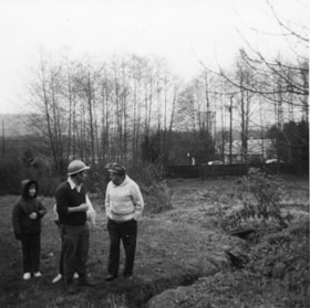
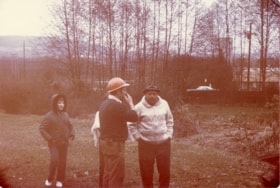
Men at Heritage Village
https://search.heritageburnaby.ca/link/museumdescription2507
- Repository
- Burnaby Village Museum
- Date
- 11 April 1971
- Collection/Fonds
- Donald Copan collection
- Description Level
- Item
- Physical Description
- 1 photograph : b&w ; 8.9 x 8.9 cm
- Scope and Content
- Photograph of two unidentifed men (one in hard hat) and two children standing in a field next to a creek bed during the official sod-turning for Heritage Village (now Burnaby Village Museum), April 11, 1971. Burnaby fire hall number is visible in the distance behind trees.
- Repository
- Burnaby Village Museum
- Collection/Fonds
- Donald Copan collection
- Series
- Copan album series
- Description Level
- Item
- Physical Description
- 1 photograph : b&w ; 8.9 x 8.9 cm
- Scope and Content
- Photograph of two unidentifed men (one in hard hat) and two children standing in a field next to a creek bed during the official sod-turning for Heritage Village (now Burnaby Village Museum), April 11, 1971. Burnaby fire hall number is visible in the distance behind trees.
- Subjects
- Events
- Geographic Features - Streams
- Names
- Burnaby Village Museum
- Accession Code
- BV005.54.556
- Access Restriction
- No restrictions
- Reproduction Restriction
- May be restricted by third party rights
- Date
- 11 April 1971
- Media Type
- Photograph
- Historic Neighbourhood
- Burnaby Lake (Historic Neighbourhood)
- Planning Study Area
- Morley-Buckingham Area
- Scan Resolution
- 600
- Scan Date
- August 18, 2020
- Scale
- 100
- Notes
- Title based on contents of photograph
Images
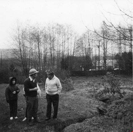
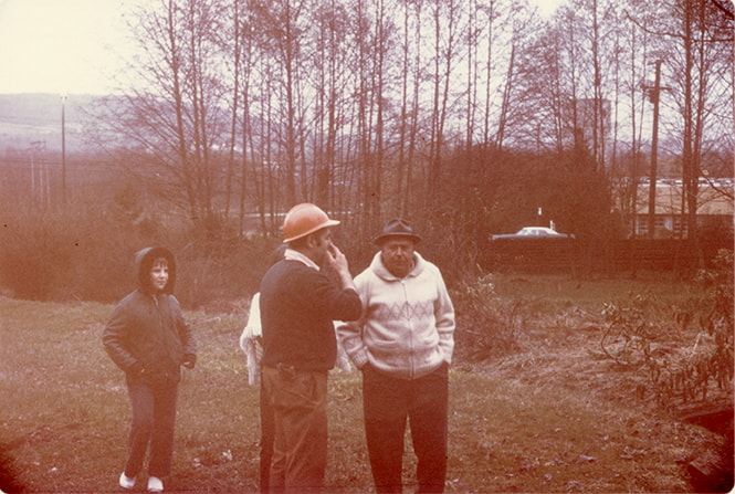
Men at on site of Heritage Village
https://search.heritageburnaby.ca/link/museumdescription13669
- Repository
- Burnaby Village Museum
- Date
- 11 April 1971
- Collection/Fonds
- Donald Copan collection
- Description Level
- Item
- Physical Description
- 1 photograph : col. ; 8.9 x 12.7 cm
- Scope and Content
- Photograph of two unidentifed men (one in hard hat) and two children standing in a field next to a creek bed during the official sod-turning for Heritage Village (now Burnaby Village Museum), April 11, 1971. Burnaby fire hall number is visible in the distance behind trees.
- Repository
- Burnaby Village Museum
- Collection/Fonds
- Donald Copan collection
- Series
- Copan album series
- Description Level
- Item
- Physical Description
- 1 photograph : col. ; 8.9 x 12.7 cm
- Scope and Content
- Photograph of two unidentifed men (one in hard hat) and two children standing in a field next to a creek bed during the official sod-turning for Heritage Village (now Burnaby Village Museum), April 11, 1971. Burnaby fire hall number is visible in the distance behind trees.
- Subjects
- Events
- Geographic Features - Streams
- Names
- Burnaby Village Museum
- Accession Code
- BV005.54.575
- Access Restriction
- No restrictions
- Reproduction Restriction
- May be restricted by third party rights
- Date
- 11 April 1971
- Media Type
- Photograph
- Historic Neighbourhood
- Burnaby Lake (Historic Neighbourhood)
- Planning Study Area
- Morley-Buckingham Area
- Scan Resolution
- 600
- Scan Date
- August 18, 2020
- Scale
- 100
- Notes
- Title based on contents of photograph
Images
British Columbia Rivers Day
https://search.heritageburnaby.ca/link/archivedescription81214
- Repository
- City of Burnaby Archives
- Date
- September 30, 1998
- Collection/Fonds
- Burnaby NewsLeader photograph collection
- Description Level
- Item
- Physical Description
- 1 photograph : b&w ; 14.5 x 22.5 cm
- Scope and Content
- Photograph of Burnaby mayor Doug Drummond, Andrew Crane, and other students participating in British Columbia Rivers Day by helping with the clean-up and fish release project at Byrne Creek.
- Repository
- City of Burnaby Archives
- Date
- September 30, 1998
- Collection/Fonds
- Burnaby NewsLeader photograph collection
- Physical Description
- 1 photograph : b&w ; 14.5 x 22.5 cm
- Description Level
- Item
- Record No.
- 535-1360
- Access Restriction
- No restrictions
- Reproduction Restriction
- No reproduction permitted
- Accession Number
- 2012-11
- Scope and Content
- Photograph of Burnaby mayor Doug Drummond, Andrew Crane, and other students participating in British Columbia Rivers Day by helping with the clean-up and fish release project at Byrne Creek.
- Media Type
- Photograph
- Photographer
- Langdeau, Brian
- Notes
- Title based on contents of photograph
- Note in black ink on recto of photograph reads: "B 1937 - Bby - Brian / Bby 15 59%"
- Trim marks and/or reproduction instructions on recto (scan is cropped)
- Accompanying caption reads: " Sept 30, 1998 1937: / Burnaby mayor Doug Drummond, Andrew Crane and other students participate in BC Rivers Day clean-up and fish release project at Byrne Creek near 18th Ave and 18th St on Sunday morning."
Images

![Dan Johnston at Taylor Park site, [2003] thumbnail](/media/hpo/_Data/_Archives_Images/_Unrestricted/535/535-2035.jpg?width=280)
Dan Johnston at Taylor Park site
https://search.heritageburnaby.ca/link/archivedescription96354
- Repository
- City of Burnaby Archives
- Date
- [2003]
- Collection/Fonds
- Burnaby NewsLeader photograph collection
- Description Level
- Item
- Physical Description
- 1 photograph (tiff) : col.
- Scope and Content
- Photograph of Burnaby Parks Commissioner Dan Johnston at the southwest view on Southpoint Drive at the area of an old landfill that is now Taylor Park.
- Repository
- City of Burnaby Archives
- Date
- [2003]
- Collection/Fonds
- Burnaby NewsLeader photograph collection
- Physical Description
- 1 photograph (tiff) : col.
- Description Level
- Item
- Record No.
- 535-2035
- Access Restriction
- No restrictions
- Reproduction Restriction
- No restrictions
- Accession Number
- 2018-12
- Scope and Content
- Photograph of Burnaby Parks Commissioner Dan Johnston at the southwest view on Southpoint Drive at the area of an old landfill that is now Taylor Park.
- Names
- Johnston, Dan
- Media Type
- Photograph
- Photographer
- Bartel, Mario
- Notes
- Title based on caption
- Collected by editorial for use in a February 2003 issue of the Burnaby NewsLeader
- Caption from metadata: "Burnaby Parks Commissioner, Dan Johnston, admires the view to the southwest from one of the lookouts to be integrated into the city's plans for Taylor Park, on Southpoint Drive. The park, to be built on an old landfill, will also include trails, a playground, meadows and an off-leash area for dogs."
- Geographic Access
- Southpoint Drive
- Historic Neighbourhood
- Edmonds (Historic Neighbourhood)
- Planning Study Area
- Stride Hill Area
Images
![Dan Johnston at Taylor Park site, [2003] thumbnail](/media/hpo/_Data/_Archives_Images/_Unrestricted/535/535-2035.jpg)

Opening of the Hastings-Barnet Road
https://search.heritageburnaby.ca/link/archivedescription38660
- Repository
- City of Burnaby Archives
- Date
- 1927
- Collection/Fonds
- Burnaby Historical Society fonds
- Description Level
- Item
- Physical Description
- 1 photograph : sepia ; 17.5 x 26.5 cm
- Scope and Content
- Photograph of the official opening of the newly paved Hastings-Barnet Road which opened on Saturday December 10, 1927. In the foreground the Provincial Minister of Public Works Dr. W.H. Sutherland is opening a wooden gate, with a large crowd gathered around. The Barnet Lumber Company Ltd. building …
- Repository
- City of Burnaby Archives
- Date
- 1927
- Collection/Fonds
- Burnaby Historical Society fonds
- Subseries
- North Burnaby Board of Trade subseries
- Physical Description
- 1 photograph : sepia ; 17.5 x 26.5 cm
- Description Level
- Item
- Record No.
- 476-003
- Access Restriction
- No restrictions
- Reproduction Restriction
- No known restrictions
- Accession Number
- BHS2005-8
- Scope and Content
- Photograph of the official opening of the newly paved Hastings-Barnet Road which opened on Saturday December 10, 1927. In the foreground the Provincial Minister of Public Works Dr. W.H. Sutherland is opening a wooden gate, with a large crowd gathered around. The Barnet Lumber Company Ltd. building on Hastings Street is in the background.
- Subjects
- Geographic Features - Roads
- Persons - Crowds
- Buildings - Industrial - Mills
- Officials - Elected Officials
- Public Services - Public Works
- Names
- Barnet Mill
- Sutherland, W.H.
- Media Type
- Photograph
- Notes
- Title based on contents of photograph
- Geographic Access
- Hastings Street
- Street Address
- 3995 Hastings Street
- Historic Neighbourhood
- Vancouver Heights (Historic Neighbourhood)
- Planning Study Area
- Burnaby Heights Area
Images

![Burnaby rivers, [2002] thumbnail](/media/hpo/_Data/_Archives_Images/_Unrestricted/535/535-2800-1.jpg?width=280)
Burnaby rivers
https://search.heritageburnaby.ca/link/archivedescription97440
- Repository
- City of Burnaby Archives
- Date
- [2002]
- Collection/Fonds
- Burnaby NewsLeader photograph collection
- Description Level
- File
- Physical Description
- 4 photographs (tiff) : col.
- Scope and Content
- File contains photographs of people with Burnaby rivers and creeks. Photographs depict BCIT river conservationist Mark Angelo posing in Deer Lake Brook by Burnaby Village Museum, and Lorna Johnson, Gordie Cook, and Jack McAfee enjoying Fraser Foreshore Park by the Fraser River.
- Repository
- City of Burnaby Archives
- Date
- [2002]
- Collection/Fonds
- Burnaby NewsLeader photograph collection
- Physical Description
- 4 photographs (tiff) : col.
- Description Level
- File
- Record No.
- 535-2800
- Access Restriction
- No restrictions
- Reproduction Restriction
- No restrictions
- Accession Number
- 2018-12
- Scope and Content
- File contains photographs of people with Burnaby rivers and creeks. Photographs depict BCIT river conservationist Mark Angelo posing in Deer Lake Brook by Burnaby Village Museum, and Lorna Johnson, Gordie Cook, and Jack McAfee enjoying Fraser Foreshore Park by the Fraser River.
- Media Type
- Photograph
- Photographer
- Bartel, Mario
- Notes
- Title based on caption
- Collected by editorial for use in a September 2002 issue of the Burnaby NewsLeader
- Caption from metadata for 535-2800-1 and 535-2800-2: "Mark Angelo, of BCIT, who's made it his mission to save and preserve Burnaby's rivers and creeks, says he's particularly proud of Deer Lake Brook, as it babbles through Burnaby Village Museum, on its way to Burnaby Lake."
- Caption from metadata for 535-2800-3: "Lorna Johnson hits a tennis ball out into the Fraser River at Fraser Foreshore Park, to her dog, Keiko."
- Caption from metadata for 535-2800-4: "Gordie Cook and Jack McAfee shoot the breeze and enjoy the sunshine along the Fraser River, at Fraser Foreshore Park in Burnaby."
- Geographic Access
- Deer Lake Brook
- Burnaby Fraser Foreshore Park
- Fraser River
- Historic Neighbourhood
- Fraser Arm (Historic Neighbourhood)
- Burnaby Lake (Historic Neighbourhood)
- Planning Study Area
- Morley-Buckingham Area
- Big Bend Area
Images
![Burnaby rivers, [2002] thumbnail](/media/hpo/_Data/_Archives_Images/_Unrestricted/535/535-2800-1.jpg)

Deer Lake Gibraltar
https://search.heritageburnaby.ca/link/archivedescription34312
- Repository
- City of Burnaby Archives
- Date
- 1924
- Collection/Fonds
- Burnaby Historical Society fonds
- Description Level
- Item
- Physical Description
- 1 photograph : b&w ; 8.1 x 13.2 cm
- Scope and Content
- Photograph of the "Gibraltar" rock at mouth of Deer Lake Creek. This photograph was taken during the winter of 1924 and the lake is frozen over with ice. The surface of the lake is covered with marks made by ice skates. Deer Lake Creek is historically known as Deer Lake Brook.
- Repository
- City of Burnaby Archives
- Date
- 1924
- Collection/Fonds
- Burnaby Historical Society fonds
- Subseries
- Peers family subseries
- Physical Description
- 1 photograph : b&w ; 8.1 x 13.2 cm
- Description Level
- Item
- Record No.
- 020-019
- Access Restriction
- No restrictions
- Reproduction Restriction
- No known restrictions
- Accession Number
- BHS2007-04
- Scope and Content
- Photograph of the "Gibraltar" rock at mouth of Deer Lake Creek. This photograph was taken during the winter of 1924 and the lake is frozen over with ice. The surface of the lake is covered with marks made by ice skates. Deer Lake Creek is historically known as Deer Lake Brook.
- Subjects
- Geographic Features - Creeks
- Geographic Features - Lakes and Ponds
- Geographic Features - Rock Formations
- Media Type
- Photograph
- Notes
- Title based on caption accompanying photograph
- Geographic Access
- Deer Lake Brook
- Historic Neighbourhood
- Burnaby Lake (Historic Neighbourhood)
- Planning Study Area
- Morley-Buckingham Area
Images

![Beaver Creek salmon release, [2001] thumbnail](/media/hpo/_Data/_Archives_Images/_Unrestricted/535/535-2497.jpg?width=280)
Beaver Creek salmon release
https://search.heritageburnaby.ca/link/archivedescription96942
- Repository
- City of Burnaby Archives
- Date
- [2001]
- Collection/Fonds
- Burnaby NewsLeader photograph collection
- Description Level
- Item
- Physical Description
- 1 photograph (tiff) : col.
- Scope and Content
- Photograph of Gail McGrath holding up a plastic bag containing water and Coho salmon fry were released into Beaver Creek during Environment Week celebrations at Deer Lake Park.
- Repository
- City of Burnaby Archives
- Date
- [2001]
- Collection/Fonds
- Burnaby NewsLeader photograph collection
- Physical Description
- 1 photograph (tiff) : col.
- Description Level
- Item
- Record No.
- 535-2497
- Access Restriction
- No restrictions
- Reproduction Restriction
- No restrictions
- Accession Number
- 2018-12
- Scope and Content
- Photograph of Gail McGrath holding up a plastic bag containing water and Coho salmon fry were released into Beaver Creek during Environment Week celebrations at Deer Lake Park.
- Media Type
- Photograph
- Photographer
- Bartel, Mario
- Notes
- Title based on caption
- Collected by editorial for use in a June 2001 issue of the Burnaby NewsLeader
- Caption from metadata: "Gail McGrath gets a close-up look at some of the 3,000 Coho fry that were released into Beaver Creek last Saturday as part of Burnaby's Environment Week celebrations at Deer Lake Park. The fry will leave the creek next May, as 20 gram smolts, heading to the Fraser River via Deer Lake, Burnaby Lake, and the Brunette River. Of the 3,000, one pair may return to the creek as spawning adults. "
- Geographic Access
- Deer Lake Park
- Deer Lake
- Historic Neighbourhood
- Burnaby Lake (Historic Neighbourhood)
- Planning Study Area
- Oakalla Area
Images
![Beaver Creek salmon release, [2001] thumbnail](/media/hpo/_Data/_Archives_Images/_Unrestricted/535/535-2497.jpg)
![Fish release for BC Rivers Week, [2000] thumbnail](/media/hpo/_Data/_Archives_Images/_Unrestricted/535/535-2700-1.jpg?width=280)
Fish release for BC Rivers Week
https://search.heritageburnaby.ca/link/archivedescription97303
- Repository
- City of Burnaby Archives
- Date
- [2000]
- Collection/Fonds
- Burnaby NewsLeader photograph collection
- Description Level
- File
- Physical Description
- 2 photographs (tiff) : col.
- Scope and Content
- File contains photographs of the fish release kickoff event for BC Rivers Week. Photographs depict Morley Rempel, a fish culturist at the Fraser Valley Trout Hatchery, moving trout into a bucket with a net and Environment Minister Joan Sawicki and the chairman of the Outdoor Recreation Council of B…
- Repository
- City of Burnaby Archives
- Date
- [2000]
- Collection/Fonds
- Burnaby NewsLeader photograph collection
- Physical Description
- 2 photographs (tiff) : col.
- Description Level
- File
- Record No.
- 535-2700
- Access Restriction
- No restrictions
- Reproduction Restriction
- No restrictions
- Accession Number
- 2018-12
- Scope and Content
- File contains photographs of the fish release kickoff event for BC Rivers Week. Photographs depict Morley Rempel, a fish culturist at the Fraser Valley Trout Hatchery, moving trout into a bucket with a net and Environment Minister Joan Sawicki and the chairman of the Outdoor Recreation Council of BC, Mark Angelo, releasing the trout in Guichon Creek.
- Names
- Sawicki, Joan
- Media Type
- Photograph
- Photographer
- Bartel, Mario
- Notes
- Title based on caption
- Collected by editorial for use in a September 2000 issue of the Burnaby NewsLeader
- Caption from metadata for 535-2700-1: "Morley Rempel, a fish culturist at the Fraser Valley Trout Hatchery, prepares the first cutthroat trout fingerlings to be released into Guichon Creek, a kickoff for BC Rivers Week."
- Caption from metadata for 535-2700-2: "Environment Minister Joan Sawicki and the chairman of the Outdoor Recreation Council of BC, Mark Angelo, release the first trout fingerlings into Guichon Creek, to celebrate its rehabilitation, and to launch BC Rivers Week."
- Planning Study Area
- Douglas-Gilpin Area
Images
![Fish release for BC Rivers Week, [2000] thumbnail](/media/hpo/_Data/_Archives_Images/_Unrestricted/535/535-2700-1.jpg)
![Great Salmon Send Off, [2000] thumbnail](/media/hpo/_Data/_Archives_Images/_Unrestricted/535/535-2414.jpg?width=280)
Great Salmon Send Off
https://search.heritageburnaby.ca/link/archivedescription96856
- Repository
- City of Burnaby Archives
- Date
- [2000]
- Collection/Fonds
- Burnaby NewsLeader photograph collection
- Description Level
- Item
- Physical Description
- 1 photograph (tiff) : col.
- Scope and Content
- Photograph of Al Hunter and his child, Kyara, releasing Coho fingerlings into Stoney Creek at the Great Salmon Send Off.
- Repository
- City of Burnaby Archives
- Date
- [2000]
- Collection/Fonds
- Burnaby NewsLeader photograph collection
- Physical Description
- 1 photograph (tiff) : col.
- Description Level
- Item
- Record No.
- 535-2414
- Access Restriction
- No restrictions
- Reproduction Restriction
- No restrictions
- Accession Number
- 2018-12
- Scope and Content
- Photograph of Al Hunter and his child, Kyara, releasing Coho fingerlings into Stoney Creek at the Great Salmon Send Off.
- Media Type
- Photograph
- Photographer
- Bartel, Mario
- Notes
- Title based on caption
- Collected by editorial for use in a May 2000 issue of the Burnaby NewsLeader
- Caption from metadata: "Kyara Hunter, 4, gets a little help from her dad, Al, releasing Coho fingerlings into Stoney Creek, at the Great Salmon Send Off on Saturday. About 4,000 young Coho, raised by the Sapperton Fish and Game Club, were released into the stream."
- Geographic Access
- Stoney Creek
- Historic Neighbourhood
- Burquitlam (Historic Neighbourhood)
- Planning Study Area
- Lyndhurst Area
Images
![Great Salmon Send Off, [2000] thumbnail](/media/hpo/_Data/_Archives_Images/_Unrestricted/535/535-2414.jpg)

Government Road
https://search.heritageburnaby.ca/link/archivedescription35567
- Repository
- City of Burnaby Archives
- Date
- 1912 (date of original), copied 1986
- Collection/Fonds
- Burnaby Historical Society fonds
- Description Level
- Item
- Physical Description
- 1 photograph : b&w ; 12.7 x 17.8 cm print
- Scope and Content
- Photograph looking east on Government Road from the Haddon family house. One of the men in the photo is Robert Haddon. The other two people are unidentified. Note the loose gravel roadway and the bridge over Eagle Creek.
- Repository
- City of Burnaby Archives
- Date
- 1912 (date of original), copied 1986
- Collection/Fonds
- Burnaby Historical Society fonds
- Subseries
- Pioneer Tales subseries
- Physical Description
- 1 photograph : b&w ; 12.7 x 17.8 cm print
- Description Level
- Item
- Record No.
- 204-425
- Access Restriction
- No restrictions
- Reproduction Restriction
- No known restrictions
- Accession Number
- BHS1988-03
- Scope and Content
- Photograph looking east on Government Road from the Haddon family house. One of the men in the photo is Robert Haddon. The other two people are unidentified. Note the loose gravel roadway and the bridge over Eagle Creek.
- Names
- Haddon, Robert
- Media Type
- Photograph
- Notes
- Title based on contents of photograph
- Geographic Access
- Eagle Creek
- Government Road
- Historic Neighbourhood
- Lozells (Historic Neighbourhood)
- Planning Study Area
- Government Road Area
Images


Stream in Robert Burnaby Park
https://search.heritageburnaby.ca/link/archivedescription93668
- Repository
- City of Burnaby Archives
- Date
- January 15, 1978
- Collection/Fonds
- Burnaby Public Library Contemporary Visual Archive Project
- Description Level
- Item
- Physical Description
- 1 photograph : b&w ; 12.5 x 17.5 cm
- Scope and Content
- Photograph of a mostly dry stream in Robert Burnaby Park. The stream is surrounded by a forested area and the photograph shows a footbridge in the background. The photograph is taken in front of the stream, facing south.
- Repository
- City of Burnaby Archives
- Date
- January 15, 1978
- Collection/Fonds
- Burnaby Public Library Contemporary Visual Archive Project
- Physical Description
- 1 photograph : b&w ; 12.5 x 17.5 cm
- Description Level
- Item
- Record No.
- 556-625
- Access Restriction
- No restrictions
- Reproduction Restriction
- Reproduce for fair dealing purposes only
- Accession Number
- 2017-57
- Scope and Content
- Photograph of a mostly dry stream in Robert Burnaby Park. The stream is surrounded by a forested area and the photograph shows a footbridge in the background. The photograph is taken in front of the stream, facing south.
- Media Type
- Photograph
- Photographer
- Surridge, Jack
- Notes
- Title taken from project information form
- Accompanied by a project information form and 1 photograph (b&w negative ; 9.5 x 12.5 cm)
- BPL no. 74
- Geographic Access
- Robert Burnaby Park
- Historic Neighbourhood
- Burnaby Lake (Historic Neighbourhood)
- Planning Study Area
- Lakeview-Mayfield Area
Images

![Anthony Ferrari tree planting in Beecher Park, [2002] thumbnail](/media/hpo/_Data/_Archives_Images/_Unrestricted/535/535-2842.jpg?width=280)
Anthony Ferrari tree planting in Beecher Park
https://search.heritageburnaby.ca/link/archivedescription97503
- Repository
- City of Burnaby Archives
- Date
- [2002]
- Collection/Fonds
- Burnaby NewsLeader photograph collection
- Description Level
- Item
- Physical Description
- 1 photograph (tiff) : col.
- Scope and Content
- Photograph of Anthony Ferrari, an athlete with the Burnaby Winter Club AAA Bantams hockey team, planting vegetation during an environmental event with the Toronto Dominion Bank in Beecher Park.
- Repository
- City of Burnaby Archives
- Date
- [2002]
- Collection/Fonds
- Burnaby NewsLeader photograph collection
- Physical Description
- 1 photograph (tiff) : col.
- Description Level
- Item
- Record No.
- 535-2842
- Access Restriction
- No restrictions
- Reproduction Restriction
- No restrictions
- Accession Number
- 2018-12
- Scope and Content
- Photograph of Anthony Ferrari, an athlete with the Burnaby Winter Club AAA Bantams hockey team, planting vegetation during an environmental event with the Toronto Dominion Bank in Beecher Park.
- Subjects
- Persons - Athletes
- Environmental Issues
- Geographic Features - Creeks
- Geographic Features - Forests
- Names
- Burnaby Winter Club
- Media Type
- Photograph
- Photographer
- Bartel, Mario
- Notes
- Title based on caption
- Collected by editorial for use in a November 2002 issue of the Burnaby NewsLeader
- Caption from metadata: "Anthony Ferrari , a player with the Burnaby Winter Club AAA Bantams, does his part to help restore the natural habitat around Beecher Creek. Members of the team joined staff from the Toronto Dominion Bank Saturday to plant trees and native vegetation in the ongoing effort to maintain the creek as a home for fish as it passes through Beecher Park."
- Geographic Access
- Beecher Park
- Springer Avenue
- Street Address
- 1255 Springer Avenue
- Planning Study Area
- Brentwood Area
Images
![Anthony Ferrari tree planting in Beecher Park, [2002] thumbnail](/media/hpo/_Data/_Archives_Images/_Unrestricted/535/535-2842.jpg)