More like 'Burnaby Mountain Parking Lot & Restaurant'
Narrow Results By
Decade
- 2020s 142
- 2010s 136
- 2000s 812
- 1990s 993
- 1980s 652
- 1970s 1278
- 1960s 471
- 1950s 621
- 1940s 675
- 1930s 704
- 1920s 797
- 1910s
- 1900s 303
- 1890s 39
- 1880s 70
- 1870s 5
- 1860s 3
- 1850s 1
- 1840s 1
- 1830s 1
- 1820s 1
- 1810s 1
- 1800s 1
- 1790s 1
- 1780s 1
- 1770s 1
- 1760s
- 1750s 1
- 1740s 1
- 1730s 1
- 1720s 1
- 1710s 1
- 1700s 1
- 1690s 1
- 1680s 1
- 1670s 1
- 1660s 1
- 1650s 1
- 1640s 1
- 1630s 1
- 1620s 1
- 1610s 1
- 1600s 1
Subject
- Advertising Medium - Signs and Signboards 7
- Agricultural Tools and Equipment - Gardening Equipment 3
- Agricultural Tools and Equipment - Plows 3
- Agriculture - Farms 9
- Animals - Bears 1
- Animals - Birds 6
- Animals - Cats 2
- Animals - Cows 1
- Animals - Deer 6
- Animals - Dogs 14
- Animals - Fish 1
- Animals - Fowl 2
Creator
- Barrowclough, G.A. 1
- BC Photo Card Company 1
- Brown, William Thomas 1
- Burnaby Village Museum 4
- Burnett and McGugan B.C. Land Surveyors, New Westminster 5
- Burnett, Geoffrey K. 3
- Burnett & McGugan, Engineers and Surveyors 22
- Canadian Photo Company 12
- Challoner-Courtenay, E.J. 2
- Dean, H.M. 16
- Disney, John Harold "Jack" 32
- Eaton, Dr. Carl 15

Edmonds Baptist Church
https://search.heritageburnaby.ca/link/landmark575
- Repository
- Burnaby Heritage Planning
- Description
- Church building.
- Associated Dates
- 1912
- Street View URL
- Google Maps Street View
- Repository
- Burnaby Heritage Planning
- Geographic Access
- Walker Avenue
- Associated Dates
- 1912
- Description
- Church building.
- Heritage Value
- Beautifully designed in an Arts and Crafts idiom, this church features a textural mix of finishes including lapped siding and stucco and half timbering in the gables. The British Columbian reported in July 1912 that: "The Baptists of Edmonds will possess a fine and well planned church when the building now commenced is ready for occupation. The architects are J.P. Matheson and Son, of Vancouver, and the contractors, Muttitt and Bell, of New Westminster. The entrance porch fronts Edmonds Road and the west side faces Vancouver Road. It will have a capacity for 272 sittings, spacious aisles and choir platform besides various rooms for Baptistery, vestry and robing apartments."
- Locality
- Edmonds
- Historic Neighbourhood
- Edmonds (Historic Neighbourhood)
- Planning Study Area
- Richmond Park Area
- Architect
- J.P. Matheson & Son
- Builder
- Muttitt and Bell
- Area
- 1471.58
- Contributing Resource
- Building
- Ownership
- Private
- Names
- Matheson, John
- Street Address
- 7135 Walker Avenue
- Street View URL
- Google Maps Street View
Images


H.T. Ceperley Estate 'Fairacres' Mansion
https://search.heritageburnaby.ca/link/landmark526
- Repository
- Burnaby Heritage Planning
- Description
- 'Fairacres' is a large, two-and-one-half storey estate house in the British Arts and Crafts style, located in Deer Lake Park, with four associated original outbuildings.
- Associated Dates
- 1911
- Formal Recognition
- Heritage Designation, Community Heritage Register
- Other Names
- Henry Tracy & Grace Ceperley Estate
- Burnaby Art Gallery
- Street View URL
- Google Maps Street View
- Repository
- Burnaby Heritage Planning
- Other Names
- Henry Tracy & Grace Ceperley Estate
- Burnaby Art Gallery
- Geographic Access
- Deer Lake Avenue
- Associated Dates
- 1911
- Formal Recognition
- Heritage Designation, Community Heritage Register
- Enactment Type
- Bylaw No. 9807
- Enactment Date
- 23/11/1992
- Description
- 'Fairacres' is a large, two-and-one-half storey estate house in the British Arts and Crafts style, located in Deer Lake Park, with four associated original outbuildings.
- Heritage Value
- 'Fairacres' is important as a record of the early years of Burnaby, specifically the Deer Lake area, as a place of tranquility and beautiful scenery in which the wealthy and successful in the burgeoning cities of New Westminster and Vancouver chose to retire or to make their family homes. The main house, which anchors in style and setting the outbuildings on the estate, demonstrates the social, cultural, and aesthetic values of local wealthy businessmen and women of the early twentieth century - values such as appreciation of architectural elegance and grand interior spaces, leisure and recreation, formal landscaped gardens and scenic views. Also important is the association with the English-born and trained architect Robert Mackay Fripp (1858-1917), as this was one of his grandest residential commissions. Steeped in the current architectural trends in Great Britain, Fripp designed this sprawling mansion in the Arts and Crafts style, reflected in the architectural detailing and proportions. The style was common at the time and was often used for estate mansions as a symbol of affluence and good, modern taste as well as an affinity for all things British. Quality is displayed inside and out in the finishes and materials, orchestrated by prominent local contractor, James Charles Allen, including imported English materials of specific value such as imported Medmenham tiles in the fireplace surrounds, one of the earliest documented use of these tiles outside the United Kingdom. Detailed features of the interior woodwork were carved by Scottish-born master wood carver George Selkirk Gibson (1867-1942), who was best known for his many commissions for prominent British Columbia architect Samuel Maclure. The outbuildings at 'Fairacres' are an important record of the functioning of a large estate of the time. The Garage and Stables and the Chauffeur’s Cottage accommodated the use of automobiles, horses and carriages, and in concert with the estate's location near the new British Columbia Electric Railway 'Burnaby Lake' interurban line, illustrate the evolving nature of regional transportation and the growing bedroom communities and estates made possible by increasing options for transportation. Other outbuildings accommodated the agricultural activities that helped support the Ceperley estate. The estate was conceived and funded by American-born Grace E. Dixon Ceperley (1863-1917), who had achieved significant wealth through a bequest from her brother-in-law, Vancouver pioneer Arthur Ferguson. Her husband, Henry Tracy Ceperley (1850-1929), also American-born, was a successful and well-respected businessman who made a significant contribution to the development of the City of Vancouver. The construction of 'Fairacres' spawned the transformation of the Deer Lake area from a farming community into a preferred location for elite suburban homes. 'Fairacres' is significant to the City of Burnaby as its first civic heritage conservation project. Acquired in 1966 for conversion to Burnaby’s first art gallery, it was dedicated in 1967 to mark Canada’s Centennial of Confederation.
- Defining Elements
- Key elements that define the heritage character of the ‘Fairacres’ mansion include its: - setting in relation to the gardens, its former market garden, and the vistas to Deer Lake and other grand homes in the area - side gable roof with prominent dormers and cedar shingle cladding - verandah across the eastern (garden) facade, with its view over the landscaped gardens and the distant mountains - porte cochere with its side steps for those arriving by automobile, and central raised step for those alighting from horse-drawn carriages - rich variety of exterior elements that demonstrate the typical Arts and Crafts use of local materials such as cobble stone chimneys and foundations, wide wooden siding and half-timbering - mixture of double-hung and casement wooden-sash windows, many with multi-paned sash - lavish interior spaces, designed for entertaining on a grand scale, including a billiard room with a beamed ceiling and an inglenook fireplace, and generous living and dining rooms arranged off a central hall - quality of the interior materials such as imported Medmenham tiles in fireplace surrounds, window hardware by Hope and Sons, and leaded stained glass - interior wood work including the staircase, and carvings by George Selkirk Gibson - remaining formal Edwardian garden landscape elements, including the cross-axial plan that reflects the relationship of the mansion to its 'outdoor rooms'
- Locality
- Deer Lake Park
- Historic Neighbourhood
- Burnaby Lake (Historic Neighbourhood)
- Planning Study Area
- Douglas-Gilpin Area
- Architect
- Robert Mackay Fripp
- Function
- Primary Current--Museum
- Primary Historic--Estate
- Community
- Burnaby
- Cadastral Identifier
- P.I.D. No. 004-493-311 Legal Description: Block 3 Except: Part subdivided by Plan 26865, District Lot 79, Group 1, New Westminster District, Plan 536
- Boundaries
- ‘Fairacres’ is comprised of a single municipally-owned property located at 6344 Deer Lake Avenue, Burnaby.
- Area
- 17,065.00
- Contributing Resource
- Building
- Landscape Feature
- Ownership
- Public (local)
- Other Collection
- City of Burnaby, Visual Art Collection: Original rendering by R.P.S. Twizell Burnaby Historical Society, Community Archives: Ceperley Photograph Album Burnaby Village Museum, Collection: Carved dining room panels by G.S. Gibson and other hardware items
- Documentation
- Heritage Site Files: PC77000 20. City of Burnaby Planning and Building Department, 4949 Canada Way, Burnaby, B.C., V5G 1M2
- Names
- Ceperley, Grace
- Ceperley, H.T.
- Fripp, Robert Mackay
- Allen, James Charles
- Gibson, George Selkirk
- Street Address
- 6344 Deer Lake Avenue
- Street View URL
- Google Maps Street View
Images


H.T. Ceperley Estate 'Fairacres' Chauffeur's Cottage
https://search.heritageburnaby.ca/link/landmark529
- Repository
- Burnaby Heritage Planning
- Description
- Designed in the British Arts and Crafts style, the Chauffeur's Cottage is situated across from the main entrance to the Ceperley Mansion, and adjacent to the Garage and Stables. A long, narrow single-storey building, it was constructed by joining together two modest estate cottages.
- Associated Dates
- 1911
- Formal Recognition
- Heritage Designation, Community Heritage Register
- Repository
- Burnaby Heritage Planning
- Geographic Access
- Deer Lake Avenue
- Associated Dates
- 1911
- Formal Recognition
- Heritage Designation, Community Heritage Register
- Enactment Type
- Bylaw No. 9807
- Enactment Date
- 23/11/1992
- Description
- Designed in the British Arts and Crafts style, the Chauffeur's Cottage is situated across from the main entrance to the Ceperley Mansion, and adjacent to the Garage and Stables. A long, narrow single-storey building, it was constructed by joining together two modest estate cottages.
- Heritage Value
- The outbuildings at 'Fairacres' are a rare surviving architecturally designed ensemble of agricultural structures that exist in complementary harmony with the main estate house. Architect Robert Mackay Fripp (1858-1917) was retained by the Ceperleys to design several original outbuildings on their estate at the same time as the main house was constructed. The Chauffeur's Cottage illustrates the increasing importance of the automobile in the lives of the wealthy of the early twentieth century. It also demonstrates Grace and Henry Tracy Ceperley's social aspirations and grand-country-estate pretension in having a chauffeur. The cottage's location - close to the garage and convenient, but not adjacent, to the main house - enhances the grand country house landscape design and contributes to the overall composition of the estate's plan. The Arts and Crafts styled Chauffeur's Cottage is important as an indicator of the aesthetic and social sensibilities of the Ceperley family in retaining an architect to design a modest building for staff accommodation.
- Defining Elements
- Key elements that define the heritage character of the 'Fairacres' Chauffeur's Cottage include its: - location, in relation to the main house and in close proximity to the Garage and Stables buildings - side gable roof with cedar shingle cladding - Arts and Crafts architectural features such as the jerkin-headed door hood, a reference to the thatched-roofed cottages of southern England; eight-paned wooden-sash casement windows; and cedar-shingled exterior - two internal brick chimneys - modest, functional interior, with simple trim and lack of pretension
- Locality
- Deer Lake Park
- Historic Neighbourhood
- Burnaby Lake (Historic Neighbourhood)
- Planning Study Area
- Douglas-Gilpin Area
- Architect
- Robert Mackay Fripp
- Function
- Primary Historic--Outbuilding
- Community
- Burnaby
- Cadastral Identifier
- P.I.D. No. 004-493-311 Legal Description: Block 3 Except: Part subdivided by Plan 26865, District Lot 79, Group 1, New Westminster District, Plan 536
- Boundaries
- ‘Fairacres’ is comprised of a single municipally-owned property located at 6344 Deer Lake Avenue, Burnaby.
- Area
- 17,065.00
- Contributing Resource
- Building
- Landscape Feature
- Ownership
- Public (local)
- Other Collection
- Burnaby Historical Society, Community Archives: Ceperley Photograph Album Burnaby Village Museum, Collection: Chinese ‘Tiger Whiskey’ and opium bottles found during restoration
- Documentation
- Heritage Site Files: PC77000 20. City of Burnaby Planning and Building Department, 4949 Canada Way, Burnaby, B.C., V5G 1M2
- Street Address
- 6344 Deer Lake Avenue
Images


H.T. Ceperley Estate 'Fairacres' Garage & Stables
https://search.heritageburnaby.ca/link/landmark530
- Repository
- Burnaby Heritage Planning
- Description
- Designed in the British Arts and Crafts style, the ‘Fairacres’ Garage and Stables is a two-storey wood frame building located on the 'Fairacres' estate, situated to the north of the Chauffeur's Cottage; at the south end of the structure is a single vehicle garage and to the north are several stable…
- Associated Dates
- 1911
- Formal Recognition
- Heritage Designation, Community Heritage Register
- Street View URL
- Google Maps Street View
- Repository
- Burnaby Heritage Planning
- Geographic Access
- Deer Lake Avenue
- Associated Dates
- 1911
- Formal Recognition
- Heritage Designation, Community Heritage Register
- Enactment Type
- Bylaw No. 9807
- Enactment Date
- 23/11/1992
- Description
- Designed in the British Arts and Crafts style, the ‘Fairacres’ Garage and Stables is a two-storey wood frame building located on the 'Fairacres' estate, situated to the north of the Chauffeur's Cottage; at the south end of the structure is a single vehicle garage and to the north are several stables for carriage, riding, and draught horses, a coach house, and tack room; the upper floor was originally a hay loft.
- Heritage Value
- The outbuildings at 'Fairacres' are a rare surviving architecturally designed ensemble of agricultural structures that exist in complementary harmony with the main estate house. Architect Robert Mackay Fripp (1858-1917) was retained by the Ceperleys to design several original outbuildings on their estate at the same time as the main house was constructed. The Garage and Stables building is important as a record of its era when transportation modes were in transition and the horse-drawn carriage, while still in use, was giving way to the automobile. The relative spatial arrangements within the building are a valuable indication of the economy of space associated with the automobile, as compared to the horse. The extent of the stabling arrangements signifies not only the use of carriage horses but also the continued reliance on draught horses in farming activities in this era. As well, it is an indication of the fashionable nature of equestrianism for wealthy families during this time. The building is important as a demonstration of the aesthetics of the Ceperley family in having an architect-designed outbuilding and obtaining craftsmanship and materials of the highest quality for each structure on their estate.
- Defining Elements
- Key elements that define the heritage character of the 'Fairacres' Garage and Stables include its: - location within easy reach of the main house and in close proximity to the Chauffeur's Cottage - floor plan with the garage at one end, close to the Chauffeur's Cottage, and stables and equine facilities at the other - variety and complexity of the roofline, including gable wall dormers, gable-on-hip roof ends, and half-hip extensions - Arts and Crafts architectural features of the exterior such as the shingle wall cladding articulated with a chevron-patterned course of shingles at the first floor level; casement windows; and deep eaves with additional purlins to support the overhang - original stable doors with hand-made forged-iron door hardware - multi-paned wooden-sash windows, some retaining original wire glass
- Locality
- Deer Lake Park
- Historic Neighbourhood
- Burnaby Lake (Historic Neighbourhood)
- Planning Study Area
- Douglas-Gilpin Area
- Architect
- Robert Mackay Fripp
- Function
- Primary Historic--Outbuilding
- Community
- Burnaby
- Cadastral Identifier
- P.I.D. No. 004-493-311 Legal Description: Block 3 Except: Part subdivided by Plan 26865, District Lot 79, Group 1, New Westminster District, Plan 536
- Boundaries
- ‘Fairacres’ is comprised of a single municipally-owned property located at 6344 Deer Lake Avenue, Burnaby.
- Area
- 17,065.00
- Contributing Resource
- Building
- Landscape Feature
- Ownership
- Public (local)
- Other Collection
- Burnaby Historical Society, Community Archives: Ceperley Photograph Album
- Documentation
- Heritage Site Files: PC77000 20. City of Burnaby Planning and Building Department, 4949 Canada Way, Burnaby, B.C., V5G 1M2
- Street Address
- 6344 Deer Lake Avenue
- Street View URL
- Google Maps Street View
Images


![Bandsand in Stanley Park, Vancouver, BC, [between 1908 and 1911] thumbnail](/media/hpo/_Data/_BVM_Images/1972/1972_0050_0010_001.jpg?width=280)
Bandsand in Stanley Park, Vancouver, BC
https://search.heritageburnaby.ca/link/museumdescription1071
- Repository
- Burnaby Village Museum
- Date
- [between 1908 and 1911]
- Collection/Fonds
- Burnaby Village Museum Photograph collection
- Description Level
- Item
- Physical Description
- 1 photograph : sepia ; 7.3 x 9.9 cm
- Scope and Content
- Photograph of people walking towards the bandstand in Stanley Park, Vancouver. In 1934, the Malkin Bowl was erected at the site where the banstand used to be. An annotation on the back of the photograph reads, "Band stand in Stanley Park where Malkin Bowl now stands."
- Repository
- Burnaby Village Museum
- Collection/Fonds
- Burnaby Village Museum Photograph collection
- Description Level
- Item
- Physical Description
- 1 photograph : sepia ; 7.3 x 9.9 cm
- Scope and Content
- Photograph of people walking towards the bandstand in Stanley Park, Vancouver. In 1934, the Malkin Bowl was erected at the site where the banstand used to be. An annotation on the back of the photograph reads, "Band stand in Stanley Park where Malkin Bowl now stands."
- Geographic Access
- Vancouver
- Accession Code
- HV972.50.10
- Access Restriction
- No restrictions
- Reproduction Restriction
- No known restrictions
- Date
- [between 1908 and 1911]
- Media Type
- Photograph
- Scan Resolution
- 600
- Scan Date
- 2023-04-04
- Photographer
- Dean, H.M.
- Notes
- Title based on contents of photograph
Images
![Bandsand in Stanley Park, Vancouver, BC, [between 1908 and 1911] thumbnail](/media/hpo/_Data/_BVM_Images/1972/1972_0050_0010_001.jpg)
Interview with Alekxos Sarter by Kathy Bossort October 16, 2015 - Track 3
https://search.heritageburnaby.ca/link/oralhistory579
- Repository
- City of Burnaby Archives
- Date Range
- 1910-1960
- Length
- 0:21:54
- Summary
- This portion of the interview is about Alekxos Sarter’s historical overview of early public recreation, and intentions to set aside parkland, on Burnaby Mountain; Acting-Commissioner Richard Bolton’s signing of By Law 1772 that created Barnet Mountain Park in 1942; and her explanation about the fun…
- Repository
- City of Burnaby Archives
- Summary
- This portion of the interview is about Alekxos Sarter’s historical overview of early public recreation, and intentions to set aside parkland, on Burnaby Mountain; Acting-Commissioner Richard Bolton’s signing of By Law 1772 that created Barnet Mountain Park in 1942; and her explanation about the function and kinds of park dedications used in Burnaby.
- Date Range
- 1910-1960
- Length
- 0:21:54
- Geographic Access
- Burnaby Mountain Conservation Area
- Interviewer
- Bossort, Kathy
- Interview Date
- October 16, 2015
- Scope and Content
- Recording is of an interview with Alekxos Sarter conducted by Kathy Bossort. Alekxos Sarter was one of 23 participants interviewed as part of the Community Heritage Commission’s Burnaby Mountain Oral History Project. The interview is mainly about the history of setting aside parkland on Burnaby Mountain from Alekxos Sarter’s perspective and experience as employee in the City of Burnaby Parks, Recreation and Cultural Services. The interview provides an excellent explanation of the history and function of kinds of park dedications used by the City of Burnaby; an overview of issues around including the Trans Mountain tank farm in the conservation area; and the background to the land use and ownership disagreement between the City of Burnaby and Simon Fraser University, its resolution, and the subsequent development of SFU’s UniverCity. Alekxos Sarter talks about Richard Bolton, Burnaby’s Acting-Commissioner who was responsible for dedicating the first park on Burnaby Mountain in 1942, and the creation of a park named after him in UniverCity.
- Biographical Notes
- Alekxos Sarter was born in Vancouver in 1961, to Daine and Kasandra Sarter. She grew up in North Vancouver and since 1994 has lived on a sailboat in False Creek. After attending UBC where she studied landscape architecture, she was hired by the City of Burnaby Parks, Recreation and Cultural Services in 1986. Working first in parks design, Alekxos quickly moved into parks planning, her preferred career. As Research Officer she covers research, planning, public consultation, parks and facility inventory, parkland acquisition, among other duties.
- Total Tracks
- 9
- Total Length
- 2:20:47
- Interviewee Name
- Sarter, Alekxos T.
- Interview Location
- City of Burnaby Parks, Recreation and Cultural Services meeting room
- Interviewer Bio
- Kathy Bossort is a retired archivist living in Ladner, BC. She worked at the Delta Museum and Archives after graduating from SLAIS (UBC) in 2001 with Masters degrees in library science and archival studies. Kathy grew up in Calgary, Alberta, and, prior to this career change, she lived in the West Kootenays, earning her living as a cook for BC tourist lodges and work camps. She continues to be interested in oral histories as a way to fill the gaps in the written record and bring richer meaning to history.
- Collection/Fonds
- Community Heritage Commission Special Projects fonds
- Media Type
- Sound Recording
Audio Tracks
Track three of interview with Alekxos Sarter
Track three of interview with Alekxos Sarter
https://search.heritageburnaby.ca/media/hpo/_Data/_Archives_Oral_Histories/_Unrestricted/MSS196-005/MSS196-005_Track_3.mp3Interview with Rick Sporns by Kathy Bossort October 30, 2015 - Track 4
https://search.heritageburnaby.ca/link/oralhistory606
- Repository
- City of Burnaby Archives
- Date Range
- 1900-2015
- Length
- 0:17:11
- Summary
- This portion of the interview is about Rick Sporn’s discussion of the value of natural areas to Burnaby, the city’s history of protecting green spaces, and the complementary role the Pavilion area plays in the Burnaby Mountain Conservation Area. He talks about how the rose garden and “Playground of…
- Repository
- City of Burnaby Archives
- Summary
- This portion of the interview is about Rick Sporn’s discussion of the value of natural areas to Burnaby, the city’s history of protecting green spaces, and the complementary role the Pavilion area plays in the Burnaby Mountain Conservation Area. He talks about how the rose garden and “Playground of the Gods” sculptures (Kamui Mintara) help Pavilion area visitors more fully appreciate the mountain setting. He also talks about the history of the construction of the Kamui Mintara sculptures.
- Date Range
- 1900-2015
- Length
- 0:17:11
- Names
- Burnaby Mountain Centennial Rose Garden
- Burnaby Mountain Centennial Park
- Burnaby Mountain Conservation Area
- Kamui Mintara
- Central Park
- Geographic Access
- Burnaby Mountain Conservation Area
- Interviewer
- Bossort, Kathy
- Interview Date
- October 30, 2015
- Scope and Content
- Recording is of an interview with Rick Sporns conducted by Kathy Bossort. Rick Sporns was one of 23 participants interviewed as part of the Community Heritage Commission’s Burnaby Mountain Oral History Project. The interview is mainly about Rick Sporn’s description of the history and design of Burnaby Mountain Centennial Rose Garden and the significance of the Centennial Pavilion area in the Burnaby Mountain Conservation Area. Rick Sporns also talks about his career with the City of Burnaby’s Parks, Recreation and Cultural Services, management of Burnaby Mountain Conservation Area, and the value of natural areas to Burnaby.
- Biographical Notes
- Richard Sporns was born in 1957 in Daly Municipality, Manitoba, to Ulrich and Charlotte Sporns. The family moved to the Burquitlam Area of Burnaby in about 1965. Rick Sporns obtained his BSc degree in biology at SFU and a degree in landscape architecture at UBC. In 1985 he began his career in the City of Burnaby’s Park, Recreation and Cultural Services department where he currently is Assistant Manager - Parks Design. Rick was responsible for designing Burnaby Mountain Centennial Rose Garden, a legacy project proposed by Mark Stockdale to commemorate Burnaby’s 1992 Centennial. The rose garden opened to the public July 18, 1992.
- Total Tracks
- 6
- Total Length
- 1:01:40
- Interviewee Name
- Sporns, Richard "Rick"
- Interview Location
- City of Burnaby Parks, Recreation and Cultural Services meeting room
- Interviewer Bio
- Kathy Bossort is a retired archivist living in Ladner, BC. She worked at the Delta Museum and Archives after graduating from SLAIS (UBC) in 2001 with Masters degrees in library science and archival studies. Kathy grew up in Calgary, Alberta, and, prior to this career change, she lived in the West Kootenays, earning her living as a cook for BC tourist lodges and work camps. She continues to be interested in oral histories as a way to fill the gaps in the written record and bring richer meaning to history.
- Collection/Fonds
- Community Heritage Commission Special Projects fonds
- Media Type
- Sound Recording
Audio Tracks
Track four of interview with Rick Sporns
Track four of interview with Rick Sporns
https://search.heritageburnaby.ca/media/hpo/_Data/_Archives_Oral_Histories/_Unrestricted/MSS196-008/MSS196-008_Track_4.mp3Interview with Tony Fabian by Kathy Bossort October 29, 2015 - Track 4
https://search.heritageburnaby.ca/link/oralhistory599
- Repository
- City of Burnaby Archives
- Date Range
- 1860-1995
- Length
- 0:15:57
- Summary
- This portion of the interview is about Tony Fabian’s description of the history of setting aside parkland on Burnaby Mountain, the creation of the Pavilion area in 1957, the history of proposals for how Burnaby Mountain could be used, the land transfer to SFU in 1963, and difficulty accessing the m…
- Repository
- City of Burnaby Archives
- Summary
- This portion of the interview is about Tony Fabian’s description of the history of setting aside parkland on Burnaby Mountain, the creation of the Pavilion area in 1957, the history of proposals for how Burnaby Mountain could be used, the land transfer to SFU in 1963, and difficulty accessing the mountain for recreation prior to 1965. He also talks about the dispute between SFU and the City of Burnaby over land ownership and control.
- Date Range
- 1860-1995
- Length
- 0:15:57
- Geographic Access
- Burnaby Mountain Conservation Area
- Interviewer
- Bossort, Kathy
- Interview Date
- October 29, 2015
- Scope and Content
- Recording is of an interview with Tony Fabian conducted by Kathy Bossort. Tony Fabian was one of 23 participants interviewed as part of the Community Heritage Commission’s Burnaby Mountain Oral History Project. The interview is mainly about Tony Fabian’s part in park creation and protection of natural areas in Burnaby, particularly as a member of the Park and Recreation Commission in the 1970s; his childhood and how that contributed to his land ethic; and the history of the uses made of and setting aside parkland on Burnaby Mountain.
- Biographical Notes
- Tony S. Fabian was born in 1934 in north Saskatchewan. At less than a year old Tony, along with his siblings, was removed from his family home and eventually placed with an immigrant farm family. As a child he worked on the farm and witnessed what he considered abusive treatment of the land and farm animals. When he was about 12 years old his adoptive family moved to the BC coast where he went on his own, working for a variety of farmers in Richmond and Delta. At 19 he contracted polio, quit farm work, and found work with the telephone company. In 1956 Tony married, and in 1957 he and his wife moved to a home on Hardwick Street in Burnaby where he still lives. Tony entered civic politics in the 1960s when he objected to development on Hardwick Park and became concerned about the destruction of Burnaby’s natural landscapes. He became a life long advocate for preserving natural areas and helped to create large parks in Burnaby on the foreshore of the Fraser River and on Burrard Inlet. He served as a member of the Parks and Recreation Commission 1970-1975, is a long time volunteer with the Burnaby Lake Park Association, and continues to stay current on local and regional environmental issues. In 2008 Tony was presented with the City of Burnaby Environment Award for Community Stewardship.
- Total Tracks
- 7
- Total Length
- 1:43:22
- Interviewee Name
- Fabian, Tony S.
- Interview Location
- Tony Fabian's home in Burnaby
- Interviewer Bio
- Kathy Bossort is a retired archivist living in Ladner, BC. She worked at the Delta Museum and Archives after graduating from SLAIS (UBC) in 2001 with Masters degrees in library science and archival studies. Kathy grew up in Calgary, Alberta, and, prior to this career change, she lived in the West Kootenays, earning her living as a cook for BC tourist lodges and work camps. She continues to be interested in oral histories as a way to fill the gaps in the written record and bring richer meaning to history.
- Collection/Fonds
- Community Heritage Commission Special Projects fonds
- Media Type
- Sound Recording
Audio Tracks
Track four of interview with Tony Fabian
Track four of interview with Tony Fabian
https://search.heritageburnaby.ca/media/hpo/_Data/_Archives_Oral_Histories/_Unrestricted/MSS196-007/MSS196-007_Track_4.mp3![Longstaff family picnic, [1919 or 1920] thumbnail](/media/hpo/_Data/_Archives_Images/_Unrestricted/251/266-001.jpg?width=280)
Longstaff family picnic
https://search.heritageburnaby.ca/link/archivedescription36419
- Repository
- City of Burnaby Archives
- Date
- [1919 or 1920]
- Collection/Fonds
- Burnaby Historical Society fonds
- Description Level
- Item
- Physical Description
- 1 photograph : b&w ; 8 x 5.5 cm
- Scope and Content
- Photograph of the Longstaff family and their friends at a picnic in Central Park. Everyone is dressed mostly in white, and four of the ten are wearing hats.
- Repository
- City of Burnaby Archives
- Date
- [1919 or 1920]
- Collection/Fonds
- Burnaby Historical Society fonds
- Subseries
- Kathleen Moore family subseries
- Physical Description
- 1 photograph : b&w ; 8 x 5.5 cm
- Description Level
- Item
- Record No.
- 266-001
- Access Restriction
- No restrictions
- Reproduction Restriction
- No known restrictions
- Accession Number
- BHS1991-33
- Scope and Content
- Photograph of the Longstaff family and their friends at a picnic in Central Park. Everyone is dressed mostly in white, and four of the ten are wearing hats.
- Media Type
- Photograph
- Notes
- Title based on contents of photograph
- Geographic Access
- Central Park
- Imperial Street
- Street Address
- 3883 Imperial Street
- Historic Neighbourhood
- Central Park (Historic Neighbourhood)
- Planning Study Area
- Maywood Area
Images
![Longstaff family picnic, [1919 or 1920] thumbnail](/media/hpo/_Data/_Archives_Images/_Unrestricted/251/266-001.jpg)
![Carnarvon Street Building, [1912] thumbnail](/media/hpo/_Data/_Archives_Images/_Unrestricted/477/477-939.jpg?width=280)
Carnarvon Street Building
https://search.heritageburnaby.ca/link/archivedescription66213
- Repository
- City of Burnaby Archives
- Date
- [1912]
- Collection/Fonds
- Peers Family and Hill Family fonds
- Description Level
- Item
- Physical Description
- 1 photograph : sepia ; 19.5 x 24 cm
- Scope and Content
- Photograph of the Carnarvon Street building in New Westminster, built by Claude Hill and E. B. Wetenhall (architect). Three cars can be seen on the street, one with two unidentified men seated inside. A note on the back of the photograph indicates that the building in the background is the New We…
- Repository
- City of Burnaby Archives
- Date
- [1912]
- Collection/Fonds
- Peers Family and Hill Family fonds
- Physical Description
- 1 photograph : sepia ; 19.5 x 24 cm
- Description Level
- Item
- Record No.
- 477-939
- Access Restriction
- No restrictions
- Reproduction Restriction
- No known restrictions
- Accession Number
- 2007-12
- Scope and Content
- Photograph of the Carnarvon Street building in New Westminster, built by Claude Hill and E. B. Wetenhall (architect). Three cars can be seen on the street, one with two unidentified men seated inside. A note on the back of the photograph indicates that the building in the background is the New Westminster Opera House and a sign on the building in the foreground reads "Ford Cars - Fraser Valley Motor Co. Limited."
- Subjects
- Transportation - Automobiles
- Buildings - Commercial
- Buildings - Commercial - Automobile Dealerships
- Media Type
- Photograph
- Notes
- Title based on contents of photograph
- Note on verso reads: "Carnarvon St. Bldg. / built by L.C. Hill & EB Wetenhall (architect) / old New Westminster Opera House / r. background - / app. 1912 -"
Images
![Carnarvon Street Building, [1912] thumbnail](/media/hpo/_Data/_Archives_Images/_Unrestricted/477/477-939.jpg)
![Gordon Presbyterian Church Refreshment Building, [1918] (date of original), copied 1987 thumbnail](/media/hpo/_Data/_Archives_Images/_Unrestricted/126/193-003.jpg?width=280)
Gordon Presbyterian Church Refreshment Building
https://search.heritageburnaby.ca/link/archivedescription35102
- Repository
- City of Burnaby Archives
- Date
- [1918] (date of original), copied 1987
- Collection/Fonds
- Burnaby Historical Society fonds
- Description Level
- Item
- Physical Description
- 1 photograph : b&w ; 8.8 x 12.5 cm print
- Scope and Content
- Photograph of the exterior of the Gordon Presbyterian Church refreshment building at the Central Park Agricultural Exhibition. Signs on the building read, "Gordon Presby Church," "Continuous Performance," "This is the Best," "Home Cooking / [illegible] just like Mother's / [Smells?] Good! Tastes B…
- Repository
- City of Burnaby Archives
- Date
- [1918] (date of original), copied 1987
- Collection/Fonds
- Burnaby Historical Society fonds
- Subseries
- Gordon Presbyterian Church subseries
- Physical Description
- 1 photograph : b&w ; 8.8 x 12.5 cm print
- Description Level
- Item
- Record No.
- 193-003
- Access Restriction
- No restrictions
- Reproduction Restriction
- No known restrictions
- Accession Number
- BHS1987-02
- Scope and Content
- Photograph of the exterior of the Gordon Presbyterian Church refreshment building at the Central Park Agricultural Exhibition. Signs on the building read, "Gordon Presby Church," "Continuous Performance," "This is the Best," "Home Cooking / [illegible] just like Mother's / [Smells?] Good! Tastes Better!," "Place to Dine," and "Hot Meals." Three women and a boy are outside the building.
- Subjects
- Exhibitions - Agricultural
- Buildings - Commercial - Restaurants
- Advertising Medium - Signs and Signboards
- Media Type
- Photograph
- Notes
- Title based on contents of photograph
- Geographic Access
- Central Park
- Imperial Street
- Street Address
- 3883 Imperial Street
- Historic Neighbourhood
- Central Park (Historic Neighbourhood)
- Planning Study Area
- Maywood Area
Images
![Gordon Presbyterian Church Refreshment Building, [1918] (date of original), copied 1987 thumbnail](/media/hpo/_Data/_Archives_Images/_Unrestricted/126/193-003.jpg)
![Gordon Presbyterian Church Refreshment Tent, [1912] (date of original), copied 1987 thumbnail](/media/hpo/_Data/_Archives_Images/_Unrestricted/126/193-001.jpg?width=280)
Gordon Presbyterian Church Refreshment Tent
https://search.heritageburnaby.ca/link/archivedescription35100
- Repository
- City of Burnaby Archives
- Date
- [1912] (date of original), copied 1987
- Collection/Fonds
- Burnaby Historical Society fonds
- Description Level
- Item
- Physical Description
- 1 photograph : b&w ; 8.8 x 12.5 cm print
- Scope and Content
- Photograph of the exterior of the Gordon Presbyterian Church refreshment tent at the Central Park Agricultural Exhibition. Banners above the door of the tent read, "Gordon Presby Church Refreshments" and "Hot Meals." Other banners and penants read, "God Save the King" and "Canada." Nine women an…
- Repository
- City of Burnaby Archives
- Date
- [1912] (date of original), copied 1987
- Collection/Fonds
- Burnaby Historical Society fonds
- Subseries
- Gordon Presbyterian Church subseries
- Physical Description
- 1 photograph : b&w ; 8.8 x 12.5 cm print
- Description Level
- Item
- Record No.
- 193-001
- Access Restriction
- No restrictions
- Reproduction Restriction
- No known restrictions
- Accession Number
- BHS1987-02
- Scope and Content
- Photograph of the exterior of the Gordon Presbyterian Church refreshment tent at the Central Park Agricultural Exhibition. Banners above the door of the tent read, "Gordon Presby Church Refreshments" and "Hot Meals." Other banners and penants read, "God Save the King" and "Canada." Nine women and two men are standing outside the tent. The women are wearing aprons. There is an automobile parked on the right side of the photograph.
- Subjects
- Buildings - Commercial - Restaurants
- Advertising Medium - Signs and Signboards
- Structures - Tents
- Media Type
- Photograph
- Notes
- Title based on contents of photograph
- Geographic Access
- Central Park
- Imperial Street
- Street Address
- 3883 Imperial Street
- Historic Neighbourhood
- Central Park (Historic Neighbourhood)
- Planning Study Area
- Maywood Area
Images
![Gordon Presbyterian Church Refreshment Tent, [1912] (date of original), copied 1987 thumbnail](/media/hpo/_Data/_Archives_Images/_Unrestricted/126/193-001.jpg)
![Gordon Presbyterian Church Refreshment Tent, [1912] (date of original), copied 1987 thumbnail](/media/hpo/_Data/_Archives_Images/_Unrestricted/126/193-002.jpg?width=280)
Gordon Presbyterian Church Refreshment Tent
https://search.heritageburnaby.ca/link/archivedescription35101
- Repository
- City of Burnaby Archives
- Date
- [1912] (date of original), copied 1987
- Collection/Fonds
- Burnaby Historical Society fonds
- Description Level
- Item
- Physical Description
- 1 photograph : b&w ; 8.7 x 12.4 cm print
- Scope and Content
- Photograph of the exterior of the Gordon Presbyterian Church refreshment tent at the Central Park Agricultural Exhibition. A sign above the door of the tent reads, "Gordon Presby Church Refreshments." Eight women and two men are standing outside the tent. The women are wearing aprons. Pennants …
- Repository
- City of Burnaby Archives
- Date
- [1912] (date of original), copied 1987
- Collection/Fonds
- Burnaby Historical Society fonds
- Subseries
- Gordon Presbyterian Church subseries
- Physical Description
- 1 photograph : b&w ; 8.7 x 12.4 cm print
- Description Level
- Item
- Record No.
- 193-002
- Access Restriction
- No restrictions
- Reproduction Restriction
- No known restrictions
- Accession Number
- BHS1987-02
- Scope and Content
- Photograph of the exterior of the Gordon Presbyterian Church refreshment tent at the Central Park Agricultural Exhibition. A sign above the door of the tent reads, "Gordon Presby Church Refreshments." Eight women and two men are standing outside the tent. The women are wearing aprons. Pennants on the tent read, "Canada."
- Subjects
- Buildings - Commercial - Restaurants
- Advertising Medium - Signs and Signboards
- Structures - Tents
- Media Type
- Photograph
- Notes
- Title based on contents of photograph
- Geographic Access
- Central Park
- Imperial Street
- Street Address
- 3883 Imperial Street
- Historic Neighbourhood
- Central Park (Historic Neighbourhood)
- Planning Study Area
- Maywood Area
Images
![Gordon Presbyterian Church Refreshment Tent, [1912] (date of original), copied 1987 thumbnail](/media/hpo/_Data/_Archives_Images/_Unrestricted/126/193-002.jpg)

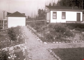
Tea Rooms
https://search.heritageburnaby.ca/link/archivedescription57696
- Repository
- City of Burnaby Archives
- Date
- 1912
- Collection/Fonds
- J.W. Phillips fonds
- Description Level
- Item
- Physical Description
- 1 photograph : b&w glass negative ; 11 x 15.5 cm
- Scope and Content
- Photograph of Tea Rooms that were built about 1910 on the same land as the Dunsford house (the Holdom Family home). Walter Holdom built the Tea Rooms to entertain prospective real estate buyers. Note the Cross soda sign beside the door. The woman sitting on the steps with an infant on her lap appea…
- Repository
- City of Burnaby Archives
- Date
- 1912
- Collection/Fonds
- J.W. Phillips fonds
- Physical Description
- 1 photograph : b&w glass negative ; 11 x 15.5 cm
- Material Details
- Emulsion measures 11 x 15.5 cm on the glass; entire glass plate measures 12 x 16 cm
- Description Level
- Item
- Record No.
- 487-006
- Access Restriction
- No restrictions
- Reproduction Restriction
- No known restrictions
- Accession Number
- 2008-18
- Scope and Content
- Photograph of Tea Rooms that were built about 1910 on the same land as the Dunsford house (the Holdom Family home). Walter Holdom built the Tea Rooms to entertain prospective real estate buyers. Note the Cross soda sign beside the door. The woman sitting on the steps with an infant on her lap appears to be Alice Turner (mother of Hetty Holdom). The other two women are most likely two of the four Turner sisters; Minnie (later Collinson), Rose (later Widdowson), Lilian (later Gledhill) or Henrietta Mary "Hetty" (Turner) Holdom.
- Subjects
- Buildings - Commercial - Restaurants
- Names
- Turner, Alice
- Media Type
- Photograph
- Photographer
- Phillips, James William "Jim"
- Notes
- Title based on contents of photograph
- Geographic Access
- Howard Avenue
- Hastings Street
- Street Address
- 5206 Hastings Street
- Historic Neighbourhood
- Capitol Hill (Historic Neighbourhood)
- Planning Study Area
- Capitol Hill Area
Images

Tea Rooms
https://search.heritageburnaby.ca/link/archivedescription57705
- Repository
- City of Burnaby Archives
- Date
- 1912
- Collection/Fonds
- J.W. Phillips fonds
- Description Level
- Item
- Physical Description
- 1 photograph : b&w glass negative ; 11 x 15.5 cm
- Scope and Content
- Photograph of Tea Rooms that were built about 1910 on the same land as the Dunsford house (the Holdom Family home). Walter Holdom built the Tea Rooms to entertain prospective real estate buyers.
- Repository
- City of Burnaby Archives
- Date
- 1912
- Collection/Fonds
- J.W. Phillips fonds
- Physical Description
- 1 photograph : b&w glass negative ; 11 x 15.5 cm
- Material Details
- Emulsion measures 11 x 15.5 cm on the glass; entire glass plate measures 12 x 16 cm
- Description Level
- Item
- Record No.
- 487-009
- Access Restriction
- No restrictions
- Reproduction Restriction
- No known restrictions
- Accession Number
- 2008-18
- Scope and Content
- Photograph of Tea Rooms that were built about 1910 on the same land as the Dunsford house (the Holdom Family home). Walter Holdom built the Tea Rooms to entertain prospective real estate buyers.
- Subjects
- Buildings - Commercial - Restaurants
- Media Type
- Photograph
- Photographer
- Phillips, James William "Jim"
- Notes
- Title based on contents of photograph
- Geographic Access
- Howard Avenue
- Hastings Street
- Street Address
- 5206 Hastings Street
- Historic Neighbourhood
- Capitol Hill (Historic Neighbourhood)
- Planning Study Area
- Capitol Hill Area
Images


Boundary Road and Hastings Street vicinity
https://search.heritageburnaby.ca/link/archivedescription35447
- Repository
- City of Burnaby Archives
- Date
- 1915 (date of original), copied 1986
- Collection/Fonds
- Burnaby Historical Society fonds
- Description Level
- Item
- Physical Description
- 1 photograph : b&w ; 12.7 x 17.8 cm print
- Scope and Content
- Photograph taken in Vancouver on Hastings Street looking east toward Burnaby and Boundary Road. The Hastings Street British Columbia Electric Railway (BCER) cars can be seen labouring up the hill.
- Repository
- City of Burnaby Archives
- Date
- 1915 (date of original), copied 1986
- Collection/Fonds
- Burnaby Historical Society fonds
- Subseries
- Pioneer Tales subseries
- Physical Description
- 1 photograph : b&w ; 12.7 x 17.8 cm print
- Description Level
- Item
- Record No.
- 204-305
- Access Restriction
- No restrictions
- Reproduction Restriction
- No restrictions
- Accession Number
- BHS1988-03
- Scope and Content
- Photograph taken in Vancouver on Hastings Street looking east toward Burnaby and Boundary Road. The Hastings Street British Columbia Electric Railway (BCER) cars can be seen labouring up the hill.
- Media Type
- Photograph
- Photographer
- Eaton, Dr. Carl
- Notes
- Title based on contents of photograph
- Geographic Access
- Boundary Road
- Hastings Street
- Historic Neighbourhood
- Vancouver Heights (Historic Neighbourhood)
- Planning Study Area
- Willingdon Heights Area
Images

![Canadian Pacific Railway Depot, [between 1908 and 1911] thumbnail](/media/hpo/_Data/_BVM_Images/1972/1972_0050_0005_002.jpg?width=280)
Canadian Pacific Railway Depot
https://search.heritageburnaby.ca/link/museumdescription1066
- Repository
- Burnaby Village Museum
- Date
- [between 1908 and 1911]
- Collection/Fonds
- Burnaby Village Museum Photograph collection
- Description Level
- Item
- Physical Description
- 1 photograph : sepia ; 8.0 x 10.2 cm, mounted on paper 13.5 x 12.2 cm
- Scope and Content
- Photograph of (in the foreground, centre) the Canadian Pacific Railway depot, Vancouver with Burrard Inlet in the background. The north shore can be seen faintly across the water. An annotation reads, "C.P.R. Depot and Burrard Inlet / From Rogers Bldg."
- Repository
- Burnaby Village Museum
- Collection/Fonds
- Burnaby Village Museum Photograph collection
- Description Level
- Item
- Physical Description
- 1 photograph : sepia ; 8.0 x 10.2 cm, mounted on paper 13.5 x 12.2 cm
- Scope and Content
- Photograph of (in the foreground, centre) the Canadian Pacific Railway depot, Vancouver with Burrard Inlet in the background. The north shore can be seen faintly across the water. An annotation reads, "C.P.R. Depot and Burrard Inlet / From Rogers Bldg."
- Accession Code
- HV972.50.5
- Access Restriction
- No restrictions
- Reproduction Restriction
- No known restrictions
- Date
- [between 1908 and 1911]
- Media Type
- Photograph
- Scan Resolution
- 600
- Scan Date
- 2023-03-28
- Photographer
- Dean, H.M.
- Notes
- Title based on contents of photograph
Images
![Canadian Pacific Railway Depot, [between 1908 and 1911] thumbnail](/media/hpo/_Data/_BVM_Images/1972/1972_0050_0005_002.jpg)
![Edmonds and Kingsway, 1912 (date of original), copied [1997] thumbnail](/media/hpo/_Data/_Archives_Images/_Unrestricted/316/350-015.jpg?width=280)
Edmonds and Kingsway
https://search.heritageburnaby.ca/link/archivedescription37321
- Repository
- City of Burnaby Archives
- Date
- 1912 (date of original), copied [1997]
- Collection/Fonds
- Burnaby Historical Society fonds
- Description Level
- Item
- Physical Description
- 1 photograph : b&w ; 9 x 12 cm print
- Scope and Content
- Photograph of the area near the Edmonds and Kingsway intersection. A British Columbia Electric Railway Company tram is visible in the centre and the station can be seen to the left.
- Repository
- City of Burnaby Archives
- Date
- 1912 (date of original), copied [1997]
- Collection/Fonds
- Burnaby Historical Society fonds
- Subseries
- Jim Wolf subseries
- Physical Description
- 1 photograph : b&w ; 9 x 12 cm print
- Description Level
- Item
- Record No.
- 350-015
- Access Restriction
- No restrictions
- Reproduction Restriction
- No known restrictions
- Accession Number
- BHS1997-09
- Scope and Content
- Photograph of the area near the Edmonds and Kingsway intersection. A British Columbia Electric Railway Company tram is visible in the centre and the station can be seen to the left.
- Media Type
- Photograph
- Notes
- Title based on contents of photograph.
- Geographic Access
- Edmonds Street
- Kingsway
- Historic Neighbourhood
- Edmonds (Historic Neighbourhood)
- Planning Study Area
- Richmond Park Area
Images
![Edmonds and Kingsway, 1912 (date of original), copied [1997] thumbnail](/media/hpo/_Data/_Archives_Images/_Unrestricted/316/350-015.jpg)
![Granville Street looking south from Rogers building, [between 1908 and 1911] thumbnail](/media/hpo/_Data/_BVM_Images/1972/1972_0050_0002_002.jpg?width=280)
Granville Street looking south from Rogers building
https://search.heritageburnaby.ca/link/museumdescription1063
- Repository
- Burnaby Village Museum
- Date
- [between 1908 and 1911]
- Collection/Fonds
- Burnaby Village Museum Photograph collection
- Description Level
- Item
- Physical Description
- 1 photograph : b&w ; 6.1 x 10.7 cm mounted on paper 13.5 x 18.3 cm
- Scope and Content
- Photograph of Granville Street in Vancouver, looking south from the Roger's Building. The two tall buildings to the sides are under construction, and steam is blowing out from building chimneys. Busy street activities can be seen below with two trams running along the tracks.Inscribed on the scrapb…
- Repository
- Burnaby Village Museum
- Collection/Fonds
- Burnaby Village Museum Photograph collection
- Description Level
- Item
- Physical Description
- 1 photograph : b&w ; 6.1 x 10.7 cm mounted on paper 13.5 x 18.3 cm
- Scope and Content
- Photograph of Granville Street in Vancouver, looking south from the Roger's Building. The two tall buildings to the sides are under construction, and steam is blowing out from building chimneys. Busy street activities can be seen below with two trams running along the tracks.Inscribed on the scrapbook paper in white ink: "Granville Street / Looking South / From Rogers Building / Vancouver B.C."
- Geographic Access
- Vancouver
- Accession Code
- HV972.50.2
- Access Restriction
- No restrictions
- Reproduction Restriction
- No known restrictions
- Date
- [between 1908 and 1911]
- Media Type
- Photograph
- Scan Resolution
- 600
- Scan Date
- 2023-03-28
- Photographer
- Dean, H.M.
- Notes
- Title based on caption of photograph
Images
![Granville Street looking south from Rogers building, [between 1908 and 1911] thumbnail](/media/hpo/_Data/_BVM_Images/1972/1972_0050_0002_002.jpg)
![Granville Street, Vancouver, [1911] thumbnail](/media/hpo/_Data/_BVM_Images/1972/1972_0050_0006_001.jpg?width=280)
Granville Street, Vancouver
https://search.heritageburnaby.ca/link/museumdescription1067
- Repository
- Burnaby Village Museum
- Date
- [1911]
- Collection/Fonds
- Burnaby Village Museum Photograph collection
- Description Level
- Item
- Physical Description
- 1 photograph : b&w ; 8.0 x 10.2 cm
- Scope and Content
- Photograph of Granville Street, looking south. The two tall buildings to the sides are under construction. Busy street activities can be seen below with two trams running along the tracks. The old Vancouver Hotel is in view and the old courthouse (later the Vancouver Art Gallery) is in view faint…
- Repository
- Burnaby Village Museum
- Collection/Fonds
- Burnaby Village Museum Photograph collection
- Description Level
- Item
- Physical Description
- 1 photograph : b&w ; 8.0 x 10.2 cm
- Scope and Content
- Photograph of Granville Street, looking south. The two tall buildings to the sides are under construction. Busy street activities can be seen below with two trams running along the tracks. The old Vancouver Hotel is in view and the old courthouse (later the Vancouver Art Gallery) is in view faintly to the right of the photograph. An annoation on the back of the photograph reads, ""Granville St. - with OLD [underlined] / Vancouver Hotel across / from the Birks Building/ 1911/ (Court House in back of Van Hotel)."
- Geographic Access
- Vancouver
- Accession Code
- HV972.50.6
- Access Restriction
- No restrictions
- Reproduction Restriction
- No known restrictions
- Date
- [1911]
- Media Type
- Photograph
- Scan Resolution
- 600
- Scan Date
- 2023-04-04
- Photographer
- Dean, H.M.
- Notes
- Title based on contents of photograph
Images
![Granville Street, Vancouver, [1911] thumbnail](/media/hpo/_Data/_BVM_Images/1972/1972_0050_0006_001.jpg)