More like 'Lakeview Elementary School'
Narrow Results By
Decade
- 2020s 96
- 2010s 43
- 2000s 480
- 1990s 398
- 1980s 405
- 1970s 943
- 1960s 280
- 1950s 463
- 1940s
- 1930s 349
- 1920s
- 1910s 445
- 1900s 173
- 1890s 23
- 1880s 49
- 1870s 3
- 1860s 1
- 1850s 1
- 1840s 1
- 1830s 1
- 1820s 1
- 1810s 1
- 1800s 1
- 1790s 1
- 1780s 1
- 1770s 1
- 1760s 1
- 1750s 1
- 1740s 1
- 1730s 1
- 1720s 1
- 1710s 1
- 1700s 1
- 1690s 1
- 1680s 1
- 1670s 1
- 1660s 1
- 1650s 1
- 1640s 1
- 1630s 1
- 1620s 1
- 1610s 1
- 1600s 1

Capitol Hill School
https://search.heritageburnaby.ca/link/landmark564
- Repository
- Burnaby Heritage Planning
- Description
- School building.
- Associated Dates
- 1923
- Other Names
- Ecole Capitol Hill Elementary School
- Street View URL
- Google Maps Street View
- Repository
- Burnaby Heritage Planning
- Other Names
- Ecole Capitol Hill Elementary School
- Geographic Access
- Holdom Avenue
- Associated Dates
- 1923
- Description
- School building.
- Heritage Value
- This school was originally designed by Bowman & Cullerne as a two-storey, four-room school building in 1923, with a two-room addition completed in 1926 and another in 1927. Originally designed in the Arts and Crafts style, it has been altered, with the addition of stucco over the original siding and replacement windows, but has retained its original form and massing, as well as its roof-top ventilator and front gabled entrance with grouped columns. Bowman & Cullerne specialized in school design. After Harold Cullerne (1890-1976) returned from service during the First World War, he joined J.H. Bowman (1864-1943) in a partnership that lasted from 1919 to 1934. The firm’s other school designs included Seaforth School (1922, now relocated to Burnaby Village Museum), Burnaby North High School (1923), and Nelson Avenue School (1927).
- Locality
- Capitol Hill
- Historic Neighbourhood
- Capitol Hill (Historic Neighbourhood)
- Planning Study Area
- Capitol Hill Area
- Architect
- Bowman & Cullerne
- Ownership
- Public (local)
- Subjects
- Buildings - Heritage
- Buildings - Schools
- Street Address
- 350 Holdom Avenue
- Street View URL
- Google Maps Street View
Images


Douglas Road School
https://search.heritageburnaby.ca/link/landmark573
- Repository
- Burnaby Heritage Planning
- Description
- School building.
- Associated Dates
- 1928
- Other Names
- Douglas Road Elementary School
- Street View URL
- Google Maps Street View
- Repository
- Burnaby Heritage Planning
- Other Names
- Douglas Road Elementary School
- Geographic Access
- Canada Way
- Associated Dates
- 1928
- Description
- School building.
- Heritage Value
- The Douglas Road School was originally established as a two-room school in 1908 on this site, and later expanded to four classrooms. Anticipating rapid settlement of this district, the School Board purchased two acres adjoining the old building. Two of the four rooms were designed to become one large auditorium suitable for special events and public gatherings, with seating for two hundred people. The classically-influenced school has been altered with new windows and extended with additional wings, but has retained its original red-brick veneer, tan-brick quoins and bellcast octagonal roof ventilator. Designed by McCarter & Nairne, the school was built by contractor A.S. Perry. McCarter & Nairne, who also designed the Second Street School, were the Burnaby School Board architects at this time. John Y. McCarter (1886-1981) and George Nairne (1884-1953) formed their partnership in 1921 after serving overseas during the First World War. The partners began designing houses and small apartment buildings, and their commissions included Vancouver’s first skyscraper, the Marine Building (1928-30).
- Locality
- Burnaby Lake
- Historic Neighbourhood
- Burnaby Lake (Historic Neighbourhood)
- Planning Study Area
- Douglas-Gilpin Area
- Architect
- McCarter & Nairne
- Subjects
- Buildings - Heritage
- Buildings - Schools
- Street Address
- 4861 Canada Way
- Street View URL
- Google Maps Street View
Images


E.W. Bateman House 'Elworth'
https://search.heritageburnaby.ca/link/landmark538
- Repository
- Burnaby Heritage Planning
- Description
- The E.W. Bateman House is a one-and-one-half storey wood-frame residence set within in a garden landscape. The house and its adjacent garage are the only historic buildings standing on their original site within the Burnaby Village Museum property.
- Associated Dates
- 1922
- Formal Recognition
- Heritage Designation, Community Heritage Register
- Other Names
- Edwin & Mary Bateman Residence
- Street View URL
- Google Maps Street View
- Repository
- Burnaby Heritage Planning
- Other Names
- Edwin & Mary Bateman Residence
- Geographic Access
- Deer Lake Avenue
- Associated Dates
- 1922
- Formal Recognition
- Heritage Designation, Community Heritage Register
- Enactment Type
- Bylaw No. 9807
- Enactment Date
- 23/11/1992
- Description
- The E.W. Bateman House is a one-and-one-half storey wood-frame residence set within in a garden landscape. The house and its adjacent garage are the only historic buildings standing on their original site within the Burnaby Village Museum property.
- Heritage Value
- The E.W. Bateman House was constructed in the Deer Lake Crescent subdivision, that was originally promoted in 1911 as an upper class suburban neighbourhood. It represents one of the first residential developments in the City of Burnaby that required buildings to be of a specific value, thus demonstrating the desire for exclusivity among the successful businessmen who chose to settle in the area. The house and grounds illustrate the reduced scale of upper-class residential construction at a time of modest returning prosperity that followed the end of the First World War, and the social, cultural, lifestyle and leisure sensibilities of the owners in the Deer Lake Crescent subdivision: such values as social aspiration, racial exclusivity, demonstration of architectural taste, and importance of a landscaped garden. The heritage value of the E.W. Bateman House is its comprehensive representation of an upper middle-class suburban residence of the early 1920s. It was built for retired CPR executive Edwin Wettenhall Bateman (1859-1957) and his wife, Mary (Dale) Bateman (1865-1935), by contractor William Dodson in 1922. The Bateman House was designed by English-born and trained architect Enoch Evans (1862-1939) of E. Evans and Son, and is an important surviving residential design by Evans, and a typical example of the eclectic Period Revival influences that were common to domestic architecture in the post-First World War era. The symmetry of the imposing front verandah, supported by exaggerated Ionic columns, gives the relatively-modest house an image of grandeur and formality. Named after Edwin Bateman’s birthplace in Cheshire, England, ‘Elworth’ also symbolizes allegiance to England and the patriotic tenor of the time. The heritage value for this house also lies in its interpretive value within the Burnaby Village Museum. The site is an important cultural feature for the interpretation of Burnaby’s heritage to the public. The E.W. Bateman House was purchased by Burnaby in 1970 and became the focal point for the development of the Museum. Both the interior and exterior of the house have been restored and interpreted to the date of original construction, including recreated room interiors and period furnishings.
- Defining Elements
- The elements that define the heritage character of the E.W. Bateman House include its: - rectangular form and massing with central entry on long side - side gable roof with front shed dormer with cedar shingle cladding - symmetry of front facade - full open front verandah inset under the roofline, supported with Ionic columns - cedar shingle siding - multi-paned double-hung wooden-sash windows, mixture of 6-over-1 and 8-over-1 - symmetrical disposition of fenestration, with double-assembly units on the ground floor - exterior shutters - two flanking brick chimneys on the side elevations - interior room layouts and original interior features such as quality millwork and original hardware - original garage at the rear of the house
- Locality
- Deer Lake Park
- Historic Neighbourhood
- Burnaby Lake (Historic Neighbourhood)
- Planning Study Area
- Morley-Buckingham Area
- Organization
- Burnaby Village Museum
- Architect
- Enoch Evans
- E. Evans and Son
- Builder
- William Dodson
- Function
- Primary Current--Museum
- Primary Historic--Single Dwelling
- Community
- Burnaby
- Cadastral Identifier
- P.I.D. No. 011-030-356 Legal Description: Parcel 1, District Lot 79 and District Lot 85, Group 1, New Westminster District, Reference Plan 77594
- Boundaries
- Burnaby Village Museum is comprised of a single municipally-owned property located at 6501 Deer Lake Avenue, Burnaby.
- Area
- 38,488.63
- Contributing Resource
- Building
- Landscape Feature
- Structure
- Ownership
- Public (local)
- Documentation
- Heritage Site Files: PC77000 20. City of Burnaby Planning and Building Department, 4949 Canada Way, Burnaby, B.C., V5G 1M2
- Subjects
- Buildings - Residential
- Buildings - Residential - Houses
- Buildings - Heritage
- Buildings - Civic - Museums
- Street Address
- 6501 Deer Lake Avenue
- Street View URL
- Google Maps Street View
Images


Barnet Lumber Company House
https://search.heritageburnaby.ca/link/landmark662
- Repository
- Burnaby Heritage Planning
- Description
- Residential building.
- Associated Dates
- 1925
- Street View URL
- Google Maps Street View
- Repository
- Burnaby Heritage Planning
- Geographic Access
- Texaco Drive
- Associated Dates
- 1925
- Description
- Residential building.
- Heritage Value
- This house is one of two surviving houses built as a “Model Home” for the manager of the Barnet Lumber Company, which was the successor to the North Pacific Lumber Company. It was used as a combined home and office. It was constructed with framing lumber and millwork sawn at the mill. Typical of the Craftsman style, the house has a front gabled roof with triangular eave brackets. It has been altered with the addition of asbestos shingles over the original siding, but retains its form, scale and massing. This house was designed by the firm of Townley & Matheson. The partnership of Fred Laughton Townley (1887-1966) and Robert Michael Matheson began in 1919, and the firm left a rich legacy of sophisticated work, including schools, commercial structures, many fine residences and the landmark Vancouver City Hall.
- Historic Neighbourhood
- Barnet (Historic Neighbourhood)
- Planning Study Area
- Burnaby Mountain Area
- Architect
- Townley & Matheson
- Area
- 2225.77
- Contributing Resource
- Building
- Ownership
- Public (local)
- Street Address
- 8007 Texaco Drive
- Street View URL
- Google Maps Street View
Images


Barnet Lumber Company House
https://search.heritageburnaby.ca/link/landmark663
- Repository
- Burnaby Heritage Planning
- Description
- Residential building.
- Associated Dates
- 1925
- Street View URL
- Google Maps Street View
- Repository
- Burnaby Heritage Planning
- Geographic Access
- Texaco Drive
- Associated Dates
- 1925
- Description
- Residential building.
- Heritage Value
- This house is one of two surviving houses built as a “Model Home” for one of the assistant managers of the Barnet Lumber Company, using framing lumber and millwork sawn at the mill. This house was also designed by the firm of Townley & Matheson. The house was raised and renovated in 1997, resulting in alterations such as new dormers and elongated porch piers.
- Historic Neighbourhood
- Barnet (Historic Neighbourhood)
- Planning Study Area
- Burnaby Mountain Area
- Architect
- Townley & Matheson
- Contributing Resource
- Building
- Ownership
- Private
- Street Address
- 8039 Texaco Drive
- Street View URL
- Google Maps Street View
Images


Capitol Hill Community Hall
https://search.heritageburnaby.ca/link/landmark563
- Repository
- Burnaby Heritage Planning
- Description
- Public building.
- Associated Dates
- 1948
- Street View URL
- Google Maps Street View
- Repository
- Burnaby Heritage Planning
- Geographic Access
- Howard Avenue
- Associated Dates
- 1948
- Description
- Public building.
- Heritage Value
- The Capitol Hill Community Hall was designed by local architect Harold Cullerne (1890-1976). After Cullerne returned from service during the First World War, he joined J.H. Bowman in a partnership that lasted from 1919 to 1934. After Bowman retired in 1934, Cullerne practiced on his own, continuing to work on schools and institutional buildings, such as the Art Deco Hollywood Theatre in Vancouver. In 1944, Cullerne designed a community hall for Capitol Hill; the scheme was delayed, and redesigned before it was finally built after the end of the Second World War. A simple front gabled roof hall structure, this hall is a monument to community spirit, erected by community members on a volunteer basis, and used for community events for over half a century. The hall replaced two earlier structures, both destroyed by fire, that had served the same purpose.
- Locality
- Capitol Hill
- Historic Neighbourhood
- Capitol Hill (Historic Neighbourhood)
- Planning Study Area
- Capitol Hill Area
- Architect
- Harold Cullerne
- Ownership
- Public (local)
- Street Address
- 361 Howard Avenue
- Street View URL
- Google Maps Street View
Images


Burnaby North High School Class
https://search.heritageburnaby.ca/link/archivedescription36833
- Repository
- City of Burnaby Archives
- Date
- 1929 (date of original), copied 1992
- Collection/Fonds
- Burnaby Historical Society fonds
- Description Level
- Item
- Physical Description
- 1 photograph : b&w ; 8.7 x 12.7 cm print
- Scope and Content
- Photograph of a Burnaby North High School class in front of Vancouver Heights Presbyterian Church. High school classes were held in the church hall temporarily. Identified: Mary Clark (2nd row, 4th from left).
- Repository
- City of Burnaby Archives
- Date
- 1929 (date of original), copied 1992
- Collection/Fonds
- Burnaby Historical Society fonds
- Subseries
- Burnaby Centennial Anthology subseries
- Physical Description
- 1 photograph : b&w ; 8.7 x 12.7 cm print
- Description Level
- Item
- Record No.
- 315-291
- Access Restriction
- No restrictions
- Reproduction Restriction
- No known restrictions
- Accession Number
- BHS1994-04
- Scope and Content
- Photograph of a Burnaby North High School class in front of Vancouver Heights Presbyterian Church. High school classes were held in the church hall temporarily. Identified: Mary Clark (2nd row, 4th from left).
- Media Type
- Photograph
- Notes
- Title based on contents of photograph
- Annotation on side of photo reads, "Mary's class"
- Geographic Access
- Triumph Street
- Street Address
- 4015 Triumph Street
- Historic Neighbourhood
- Vancouver Heights (Historic Neighbourhood)
- Planning Study Area
- Burnaby Heights Area
Images

![Parliament family home, the Half-House, [1928] thumbnail](/media/hpo/_Data/_Archives_Images/_Unrestricted/204/204-385.jpg?width=280)
Parliament family home, the Half-House
https://search.heritageburnaby.ca/link/archivedescription35527
- Repository
- City of Burnaby Archives
- Date
- [1928]
- Collection/Fonds
- Burnaby Historical Society fonds
- Description Level
- Item
- Physical Description
- 1 photograph : b&w ; 12.7 x 17.8 cm print
- Scope and Content
- Photograph of the Parliament family home, the famous landmark "half-house" on the 5770 block of Hastings Street, Capitol Hill. The photograph was taken looking north to Capitol Hill and Capitol Hill School is visible at the left.
- Repository
- City of Burnaby Archives
- Date
- [1928]
- Collection/Fonds
- Burnaby Historical Society fonds
- Subseries
- Pioneer Tales subseries
- Physical Description
- 1 photograph : b&w ; 12.7 x 17.8 cm print
- Description Level
- Item
- Record No.
- 204-385
- Access Restriction
- No restrictions
- Reproduction Restriction
- No known restrictions
- Accession Number
- BHS1988-03
- Scope and Content
- Photograph of the Parliament family home, the famous landmark "half-house" on the 5770 block of Hastings Street, Capitol Hill. The photograph was taken looking north to Capitol Hill and Capitol Hill School is visible at the left.
- Names
- Capitol Hill School
- Media Type
- Photograph
- Notes
- Title based on contents of photograph
- Annotations on top and bottom of photograph read, "The 'Half House'" / "Taken from 'The Tree'"
- Geographic Access
- Hastings Street
- Historic Neighbourhood
- Capitol Hill (Historic Neighbourhood)
- Planning Study Area
- Parkcrest-Aubrey Area
Images
![Parliament family home, the Half-House, [1928] thumbnail](/media/hpo/_Data/_Archives_Images/_Unrestricted/204/204-385.jpg)

Armstrong Avenue School
https://search.heritageburnaby.ca/link/archivedescription35043
- Repository
- City of Burnaby Archives
- Date
- 1949 (date of original), copied 1986
- Collection/Fonds
- Burnaby Historical Society fonds
- Description Level
- Item
- Physical Description
- 1 photograph : col. ; 8.8 x 12.5 cm print
- Scope and Content
- Photograph of the exterior of Armstrong Avenue School in the snow. A car is parked outside.
- Repository
- City of Burnaby Archives
- Date
- 1949 (date of original), copied 1986
- Collection/Fonds
- Burnaby Historical Society fonds
- Subseries
- Chamberlain family subseries
- Physical Description
- 1 photograph : col. ; 8.8 x 12.5 cm print
- Description Level
- Item
- Record No.
- 179-014
- Access Restriction
- No restrictions
- Reproduction Restriction
- Reproduce for fair dealing purposes only
- Accession Number
- BHS1986-27
- Scope and Content
- Photograph of the exterior of Armstrong Avenue School in the snow. A car is parked outside.
- Names
- Armstrong Avenue School
- Media Type
- Photograph
- Notes
- Title based on contents of photograph
- Print made from col. slide
- Geographic Access
- Armstrong Avenue
- Street Address
- 8757 Armstrong Avenue
- Historic Neighbourhood
- East Burnaby (Historic Neighbourhood)
- Planning Study Area
- Cariboo-Armstrong Area
Images

![Barnet school class, [between 1941 and 1942] (date of original), copied 2004 thumbnail](/media/hpo/_Data/_BVM_Images/2019/2019_0032_0005_001.jpg?width=280)
Barnet school class
https://search.heritageburnaby.ca/link/museumdescription15184
- Repository
- Burnaby Village Museum
- Date
- [between 1941 and 1942] (date of original), copied 2004
- Collection/Fonds
- In the Shadow by the Sea collection
- Description Level
- Item
- Physical Description
- 1 photograph (tiff) : 300 dpi
- Scope and Content
- Photograph of Barnet School elementary class, 1941-1942. The group of students are arranged outside in three rows with trees behind them. Students are identified from left to right as; front row: Kenny Marshall, unknown, Lakhbeer Siddoo, Gurdeb Siddoo, Bobby Karppinen, unknown, Hardev Siddoo; middl…
- Repository
- Burnaby Village Museum
- Collection/Fonds
- In the Shadow by the Sea collection
- Description Level
- Item
- Physical Description
- 1 photograph (tiff) : 300 dpi
- Scope and Content
- Photograph of Barnet School elementary class, 1941-1942. The group of students are arranged outside in three rows with trees behind them. Students are identified from left to right as; front row: Kenny Marshall, unknown, Lakhbeer Siddoo, Gurdeb Siddoo, Bobby Karppinen, unknown, Hardev Siddoo; middle row: Moyra Foort, Rose Johnston, Doreen Karppinen, Deirdre Davidson, Freda Hall, Joan Lynch, Sheila Carey, Catherine La Favor, Beatrice Woolsey and Goglin; back row: Bobby Goglin, Jackie Marshall, Ken Murray, Gurmeet Gurdell, Florence La Favor, Diljeet Teja, Colin Simmons, Ronny Johnson.
- Names
- Barnet School
- Marshall, Kenny
- Siddoo, Hardev
- Siddoo, Lakhbeer
- Siddoo, Gurdeb
- Karppinen, Robert "Bobby"
- Foort, Moyra
- Johnston, Rose
- Karppinen, Doreen
- Davidson, Dierdre
- Hall, Freda
- Lynch, Joan
- Carey, Sheila
- La Favor, Cathryn Bernice
- McMillan, Beatrice Woolsey
- Goglin, Robert "Bobby"
- Marshall, Jack Darrel "Jackie"
- Murray, Ken
- Gurdell, Gurmeet
- La Favor, Florence Alice
- Teja, Diljeet
- Simmons, Colin
- Johnson, Ron "Ronny"
- Accession Code
- BV019.32.5
- Access Restriction
- No restrictions
- Reproduction Restriction
- May be restricted by third party rights
- Date
- [between 1941 and 1942] (date of original), copied 2004
- Media Type
- Photograph
- Historic Neighbourhood
- Barnet (Historic Neighbourhood)
- Planning Study Area
- Burnaby Mountain Area
- Notes
- Title based on contents of photograph
- see page 235 in the book "In the Shadow by the Sea - recollections of Burnaby's Barnet Village". Caption with photograph reads: "Barnet School / Class 1941-1942 / Back Row:..."
Images
![Barnet school class, [between 1941 and 1942] (date of original), copied 2004 thumbnail](/media/hpo/_Data/_BVM_Images/2019/2019_0032_0005_001.jpg)
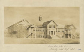
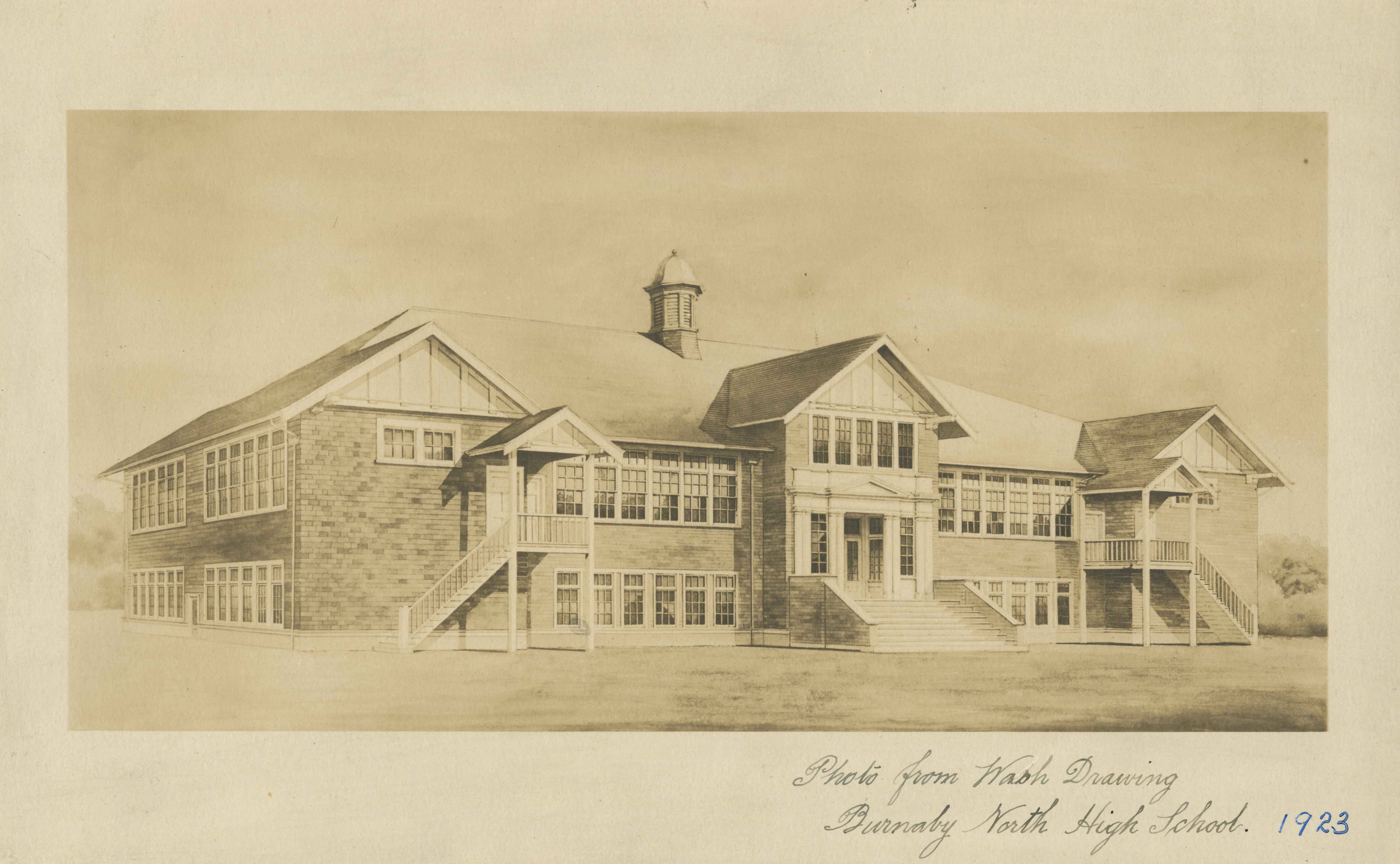
Burnaby North High School
https://search.heritageburnaby.ca/link/archivedescription34514
- Repository
- City of Burnaby Archives
- Date
- September 1923
- Collection/Fonds
- Burnaby Historical Society fonds
- Description Level
- Item
- Physical Description
- 1 photograph : b&w ; 16.0 x 25.5 cm
- Scope and Content
- Photograph of a wash drawing of the exterior of Burnaby North High School. This building later became Rosser Elementary School.
- Repository
- City of Burnaby Archives
- Date
- September 1923
- Collection/Fonds
- Burnaby Historical Society fonds
- Subseries
- Jeanie Brown subseries
- Physical Description
- 1 photograph : b&w ; 16.0 x 25.5 cm
- Description Level
- Item
- Record No.
- 033-002
- Access Restriction
- No restrictions
- Reproduction Restriction
- No known restrictions
- Accession Number
- BHS2007-04
- Scope and Content
- Photograph of a wash drawing of the exterior of Burnaby North High School. This building later became Rosser Elementary School.
- Media Type
- Photograph
- Notes
- Title based on contents of photograph
- Annotation at bottom of photograph reads, "Photo from Wash Drawing / Burnaby North High School"
- Annotation on back of photograph reads, "Compliments of the Architects Bowrman and Cullerne, September, 1923"
- Geographic Access
- Pandora Street
- Street Address
- 4375 Pandora Street
- Historic Neighbourhood
- Vancouver Heights (Historic Neighbourhood)
- Planning Study Area
- Burnaby Heights Area
Images
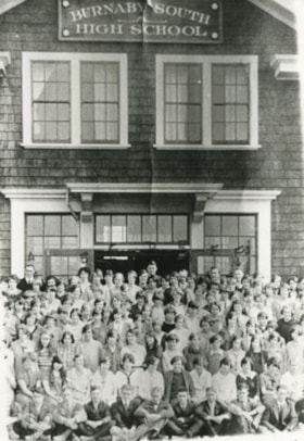
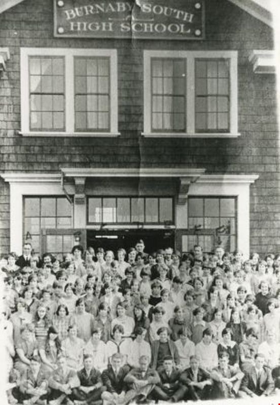
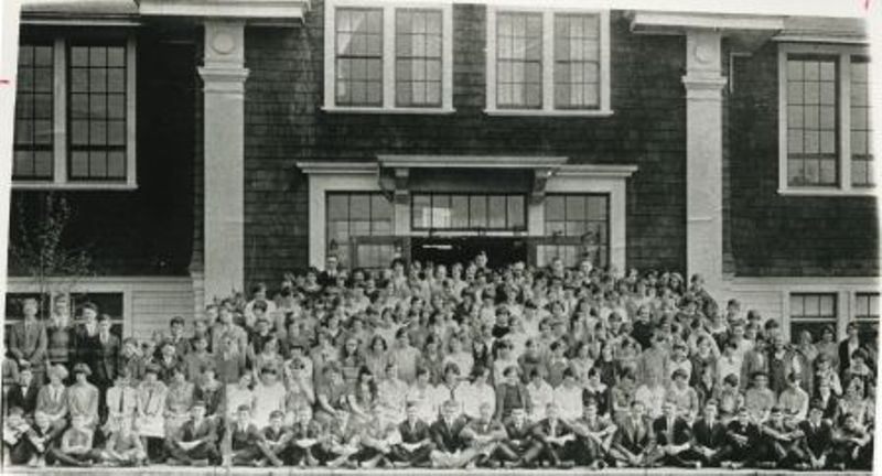
Burnaby South High school
https://search.heritageburnaby.ca/link/archivedescription35169
- Repository
- City of Burnaby Archives
- Date
- 1925 (date of original), copied 1986
- Collection/Fonds
- Burnaby Historical Society fonds
- Description Level
- Item
- Physical Description
- 1 photograph : b&w ; 12.7 x 17.8 cm print
- Scope and Content
- Photograph of the students and staff at Burnaby South High School. Thomas "Tom" Chalmers is 7th from the left in the front row, to the right of the boy wearing a bow tie. Gladys Robins has also been identified as being the girl wearing the striped shirt in the third row from the bottom, third over…
- Repository
- City of Burnaby Archives
- Date
- 1925 (date of original), copied 1986
- Collection/Fonds
- Burnaby Historical Society fonds
- Subseries
- Pioneer Tales subseries
- Physical Description
- 1 photograph : b&w ; 12.7 x 17.8 cm print
- Description Level
- Item
- Record No.
- 204-026
- Access Restriction
- No restrictions
- Reproduction Restriction
- No known restrictions
- Accession Number
- BHS1988-03
- Scope and Content
- Photograph of the students and staff at Burnaby South High School. Thomas "Tom" Chalmers is 7th from the left in the front row, to the right of the boy wearing a bow tie. Gladys Robins has also been identified as being the girl wearing the striped shirt in the third row from the bottom, third over from the left.
- Subjects
- Buildings - Schools
- Media Type
- Photograph
- Notes
- Title based on contents of photograph
- Geographic Access
- Kingsway
- Southoaks Crescent
- Street Address
- 6650 Southoaks Crescent
- Historic Neighbourhood
- Edmonds (Historic Neighbourhood)
- Planning Study Area
- Kingsway-Beresford Area
Images
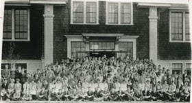
Burnaby South High School
https://search.heritageburnaby.ca/link/archivedescription35171
- Repository
- City of Burnaby Archives
- Date
- 1925 (date of original), copied 1986
- Collection/Fonds
- Burnaby Historical Society fonds
- Description Level
- Item
- Physical Description
- 1 photograph : b&w ; 12.7 x 17.8 cm print
- Scope and Content
- Photograph of students and staff at Burnaby South High School. Thomas "Tom" Chalmers is identified as number eight.
- Repository
- City of Burnaby Archives
- Date
- 1925 (date of original), copied 1986
- Collection/Fonds
- Burnaby Historical Society fonds
- Subseries
- Pioneer Tales subseries
- Physical Description
- 1 photograph : b&w ; 12.7 x 17.8 cm print
- Description Level
- Item
- Record No.
- 204-028
- Access Restriction
- No restrictions
- Reproduction Restriction
- No known restrictions
- Accession Number
- BHS1988-03
- Scope and Content
- Photograph of students and staff at Burnaby South High School. Thomas "Tom" Chalmers is identified as number eight.
- Subjects
- Buildings - Schools
- Media Type
- Photograph
- Notes
- Title based on contents of photograph
- Geographic Access
- Kingsway
- Southoaks Crescent
- Street Address
- 6650 Southoaks Crescent
- Historic Neighbourhood
- Edmonds (Historic Neighbourhood)
- Planning Study Area
- Kingsway-Beresford Area
Images
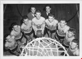
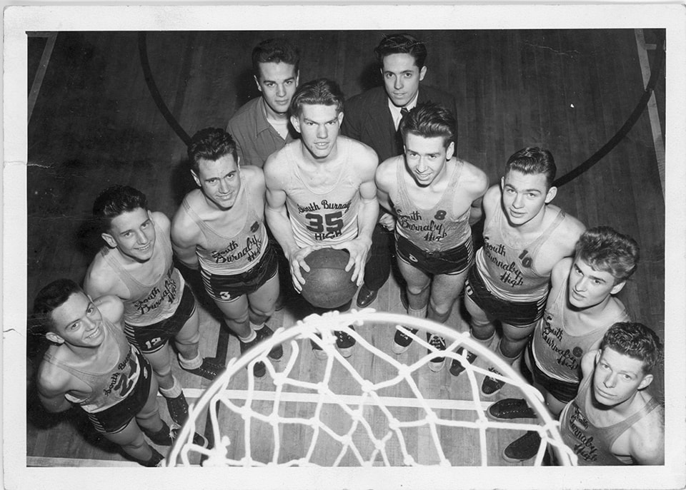
Burnaby South High School basketball team
https://search.heritageburnaby.ca/link/museumdescription15355
- Repository
- Burnaby Village Museum
- Date
- 1945 (date of original), copied 2020
- Collection/Fonds
- Burnaby Village Museum Photograph collection
- Description Level
- Item
- Physical Description
- 1 photograph (tiff) : b&w ; 1200 dpi
- Scope and Content
- Photograph of the Burnaby South Highschool basketball team. Members of the team are gathered around a basketball net in the school gymnasium. Team manager, Lavergne "Vern" Hurley is standing in the back row (left) next to coach, Terry Julian (right). Basketball players are identified as: Ken Swalwe…
- Repository
- Burnaby Village Museum
- Collection/Fonds
- Burnaby Village Museum Photograph collection
- Description Level
- Item
- Physical Description
- 1 photograph (tiff) : b&w ; 1200 dpi
- Scope and Content
- Photograph of the Burnaby South Highschool basketball team. Members of the team are gathered around a basketball net in the school gymnasium. Team manager, Lavergne "Vern" Hurley is standing in the back row (left) next to coach, Terry Julian (right). Basketball players are identified as: Ken Swalwell (#35- holding basketball); Bill Popowich (#10-third from right); David Cordis (#8-fourth from right) and Fred Forshaw (far right), other players are unidentified. The photograph has been taken from above the basketball court.
- Names
- Burnaby South High School
- Hurley, Lavergne "Vern"
- Julian, Terry
- Swalwell, Ken
- Popowich, Bill
- Cordis, Dave
- Forshaw, Fred
- Geographic Access
- Pandora Street
- Street Address
- 4375 Pandora Street
- Accession Code
- BV020.39.1
- Access Restriction
- No restrictions
- Reproduction Restriction
- May be restricted by third party rights
- Date
- 1945 (date of original), copied 2020
- Media Type
- Photograph
- Historic Neighbourhood
- Vancouver Heights (Historic Neighbourhood)
- Planning Study Area
- Burnaby Heights Area
- Scan Resolution
- 600
- Scan Date
- March 25, 2021
- Scale
- 100
- Photographer
- Henderson, Norman "Norm"
- Notes
- Title based on contents of photograph
- Stamp on verso of photograph reads: "Photograph by / Norman M. Henderson"
Images
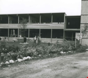
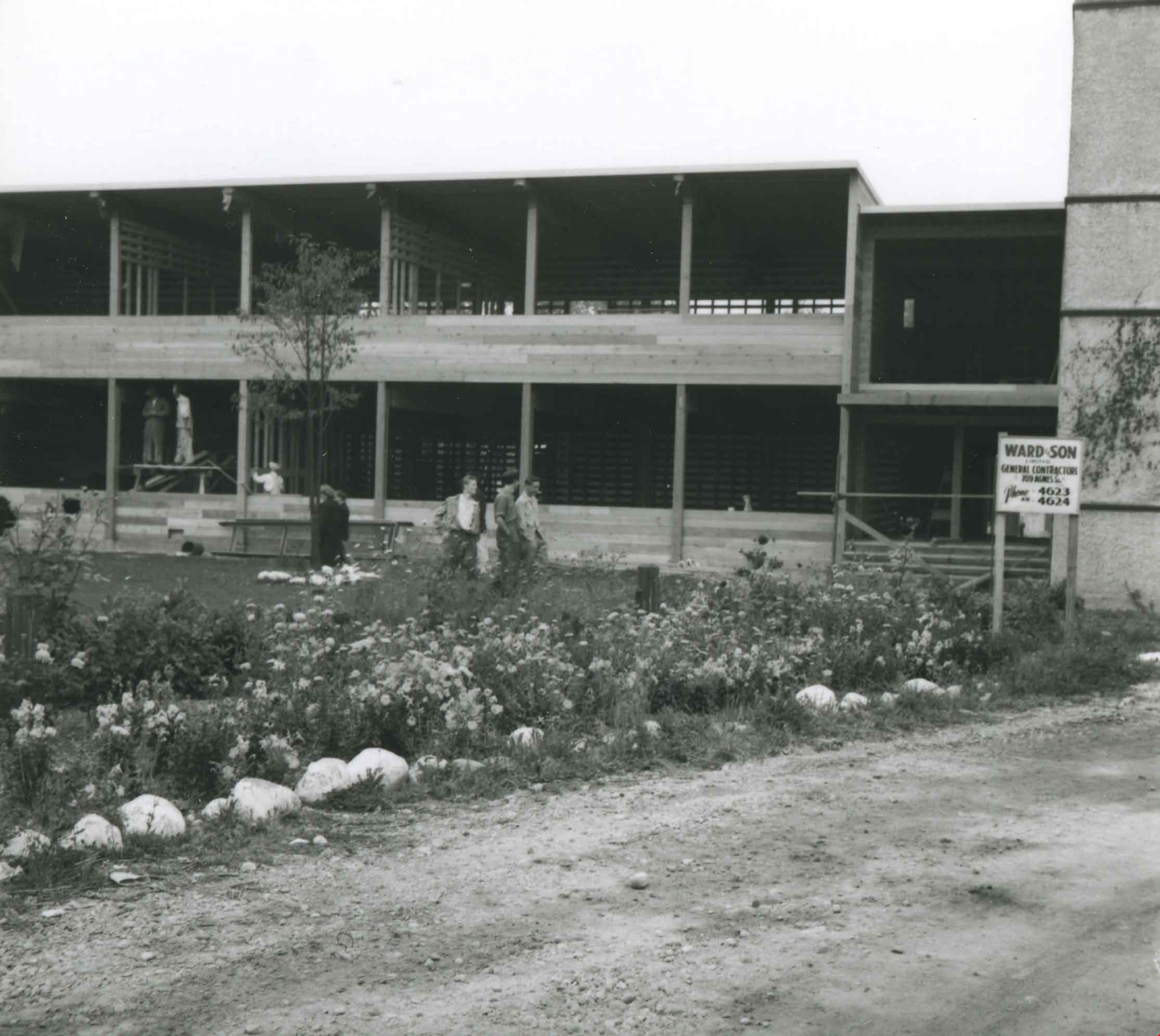
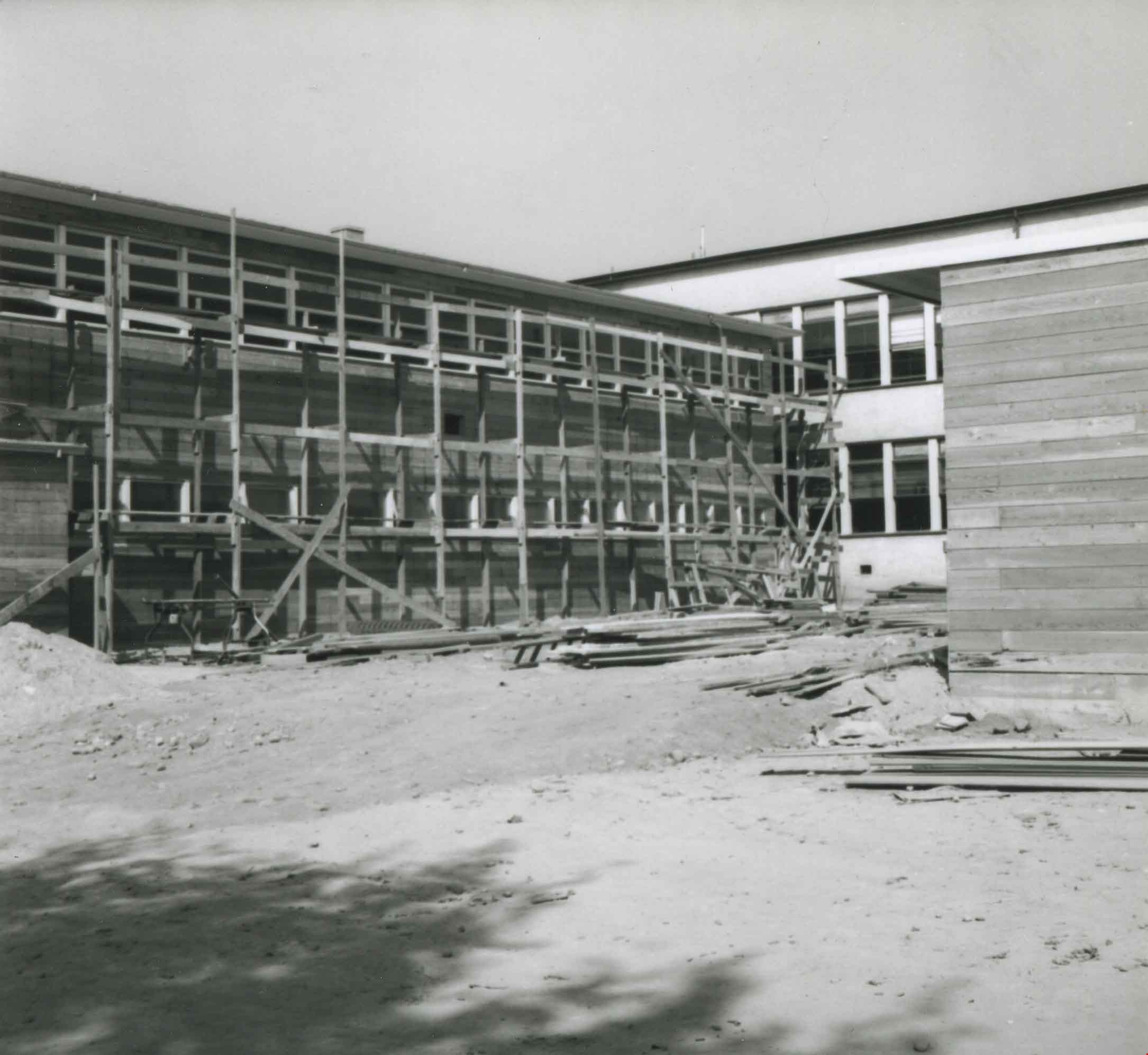
Burnaby South High School classroom construction
https://search.heritageburnaby.ca/link/archivedescription36949
- Repository
- City of Burnaby Archives
- Date
- 1942 (date of original), copied 1992
- Collection/Fonds
- Burnaby Historical Society fonds
- Description Level
- Item
- Physical Description
- 1 photograph : b&w ; 8.6 x 9.5 cm print
- Scope and Content
- Photograph of the construction of classrooms at Burnaby South High School. A sign for Ward and Son general contractors is outside.
- Repository
- City of Burnaby Archives
- Date
- 1942 (date of original), copied 1992
- Collection/Fonds
- Burnaby Historical Society fonds
- Subseries
- Burnaby Centennial Anthology subseries
- Physical Description
- 1 photograph : b&w ; 8.6 x 9.5 cm print
- Description Level
- Item
- Record No.
- 315-407
- Access Restriction
- No restrictions
- Reproduction Restriction
- No known restrictions
- Accession Number
- BHS1994-04
- Scope and Content
- Photograph of the construction of classrooms at Burnaby South High School. A sign for Ward and Son general contractors is outside.
- Subjects
- Construction
- Buildings - Schools
- Media Type
- Photograph
- Notes
- Title based on contents of photograph
- Geographic Access
- Southoaks Crescent
- Street Address
- 6650 Southoaks Crescent
- Historic Neighbourhood
- Edmonds (Historic Neighbourhood)
- Planning Study Area
- Kingsway-Beresford Area
Images
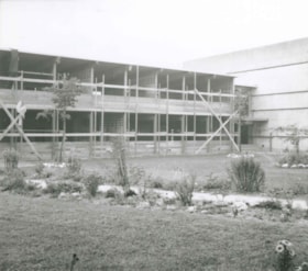
Burnaby South High School classroom construction
https://search.heritageburnaby.ca/link/archivedescription36950
- Repository
- City of Burnaby Archives
- Date
- 1942 (date of original), copied 1992
- Collection/Fonds
- Burnaby Historical Society fonds
- Description Level
- Item
- Physical Description
- 1 photograph : b&w ; 8.5 x 9.2 cm print
- Scope and Content
- Photograph of the construction of classrooms at Burnaby South High School, exterior.
- Repository
- City of Burnaby Archives
- Date
- 1942 (date of original), copied 1992
- Collection/Fonds
- Burnaby Historical Society fonds
- Subseries
- Burnaby Centennial Anthology subseries
- Physical Description
- 1 photograph : b&w ; 8.5 x 9.2 cm print
- Description Level
- Item
- Record No.
- 315-408
- Access Restriction
- No restrictions
- Reproduction Restriction
- No known restrictions
- Accession Number
- BHS1994-04
- Scope and Content
- Photograph of the construction of classrooms at Burnaby South High School, exterior.
- Subjects
- Construction
- Buildings - Schools
- Media Type
- Photograph
- Notes
- Title based on contents of photograph
- Geographic Access
- Southoaks Crescent
- Street Address
- 6650 Southoaks Crescent
- Historic Neighbourhood
- Edmonds (Historic Neighbourhood)
- Planning Study Area
- Kingsway-Beresford Area
Images
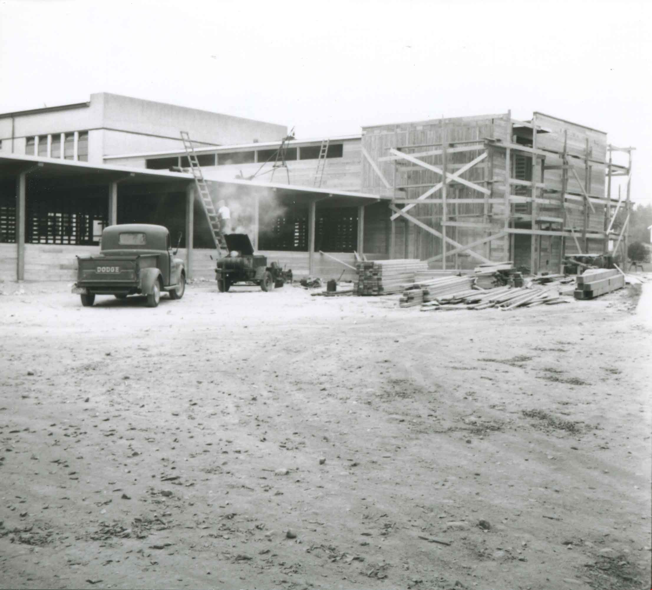
Burnaby South High School Classroom Construction
https://search.heritageburnaby.ca/link/archivedescription36951
- Repository
- City of Burnaby Archives
- Date
- 1942 (date of original), copied 1992
- Collection/Fonds
- Burnaby Historical Society fonds
- Description Level
- Item
- Physical Description
- 1 photograph : b&w ; 8.7 x 9.6 cm print
- Scope and Content
- Photograph of the construction of classrooms at Burnaby South High School, exterior.
- Repository
- City of Burnaby Archives
- Date
- 1942 (date of original), copied 1992
- Collection/Fonds
- Burnaby Historical Society fonds
- Subseries
- Burnaby Centennial Anthology subseries
- Physical Description
- 1 photograph : b&w ; 8.7 x 9.6 cm print
- Description Level
- Item
- Record No.
- 315-409
- Access Restriction
- No restrictions
- Reproduction Restriction
- No known restrictions
- Accession Number
- BHS1994-04
- Scope and Content
- Photograph of the construction of classrooms at Burnaby South High School, exterior.
- Subjects
- Construction
- Buildings - Schools
- Media Type
- Photograph
- Notes
- Title based on contents of photograph
- Geographic Access
- Southoaks Crescent
- Street Address
- 6650 Southoaks Crescent
- Historic Neighbourhood
- Edmonds (Historic Neighbourhood)
- Planning Study Area
- Kingsway-Beresford Area
Images

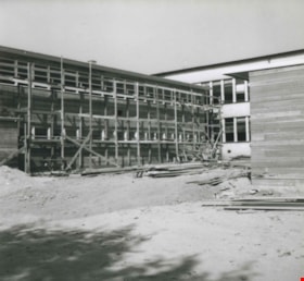
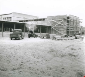
Burnaby South High School Gym construction
https://search.heritageburnaby.ca/link/archivedescription36947
- Repository
- City of Burnaby Archives
- Date
- 1942 (date of original), copied 1992
- Collection/Fonds
- Burnaby Historical Society fonds
- Description Level
- Item
- Physical Description
- 1 photograph : b&w ; 8.6 x 9.7 cm print
- Scope and Content
- Photograph of the construction of the gymnasium at Burnaby South High School.
- Repository
- City of Burnaby Archives
- Date
- 1942 (date of original), copied 1992
- Collection/Fonds
- Burnaby Historical Society fonds
- Subseries
- Burnaby Centennial Anthology subseries
- Physical Description
- 1 photograph : b&w ; 8.6 x 9.7 cm print
- Description Level
- Item
- Record No.
- 315-405
- Access Restriction
- No restrictions
- Reproduction Restriction
- No known restrictions
- Accession Number
- BHS1994-04
- Scope and Content
- Photograph of the construction of the gymnasium at Burnaby South High School.
- Subjects
- Construction
- Buildings - Schools
- Media Type
- Photograph
- Notes
- Title based on contents of photograph
- Geographic Access
- Southoaks Crescent
- Street Address
- 6650 Southoaks Crescent
- Historic Neighbourhood
- Edmonds (Historic Neighbourhood)
- Planning Study Area
- Kingsway-Beresford Area
Images

Burnaby South High School gym construction
https://search.heritageburnaby.ca/link/archivedescription36948
- Repository
- City of Burnaby Archives
- Date
- 1942 (date of original), copied 1992
- Collection/Fonds
- Burnaby Historical Society fonds
- Description Level
- Item
- Physical Description
- 1 photograph : b&w ; 8.5 x 9.5 cm print
- Scope and Content
- Photograph of the construction of the gymnasium at Burnaby South High School.
- Repository
- City of Burnaby Archives
- Date
- 1942 (date of original), copied 1992
- Collection/Fonds
- Burnaby Historical Society fonds
- Subseries
- Burnaby Centennial Anthology subseries
- Physical Description
- 1 photograph : b&w ; 8.5 x 9.5 cm print
- Description Level
- Item
- Record No.
- 315-406
- Access Restriction
- No restrictions
- Reproduction Restriction
- No known restrictions
- Accession Number
- BHS1994-04
- Scope and Content
- Photograph of the construction of the gymnasium at Burnaby South High School.
- Subjects
- Construction
- Buildings - Schools
- Media Type
- Photograph
- Notes
- Title based on contents of photograph
- Geographic Access
- Southoaks Crescent
- Street Address
- 6650 Southoaks Crescent
- Historic Neighbourhood
- Edmonds (Historic Neighbourhood)
- Planning Study Area
- Kingsway-Beresford Area
Images
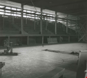
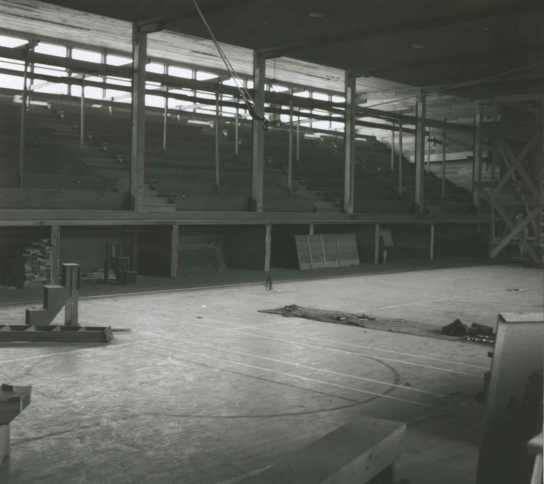
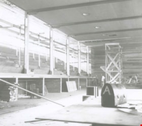
Burnaby South High School gym construction
https://search.heritageburnaby.ca/link/archivedescription36952
- Repository
- City of Burnaby Archives
- Date
- 1942 (date of original), copied 1992
- Collection/Fonds
- Burnaby Historical Society fonds
- Description Level
- Item
- Physical Description
- 1 photograph : b&w ; 8.5 x 9.6 cm print
- Scope and Content
- Photograph of the construction of the gymnasium at Burnaby South High School, interior.
- Repository
- City of Burnaby Archives
- Date
- 1942 (date of original), copied 1992
- Collection/Fonds
- Burnaby Historical Society fonds
- Subseries
- Burnaby Centennial Anthology subseries
- Physical Description
- 1 photograph : b&w ; 8.5 x 9.6 cm print
- Description Level
- Item
- Record No.
- 315-410
- Access Restriction
- No restrictions
- Reproduction Restriction
- No known restrictions
- Accession Number
- BHS1994-04
- Scope and Content
- Photograph of the construction of the gymnasium at Burnaby South High School, interior.
- Subjects
- Construction
- Buildings - Schools
- Media Type
- Photograph
- Notes
- Title based on contents of photograph
- Geographic Access
- Southoaks Crescent
- Street Address
- 6650 Southoaks Crescent
- Historic Neighbourhood
- Edmonds (Historic Neighbourhood)
- Planning Study Area
- Kingsway-Beresford Area
Images