More like 'Some of our homes'
Narrow Results By
Decade
- 2020s 97
- 2010s 44
- 2000s 493
- 1990s 422
- 1980s 423
- 1970s
- 1960s 317
- 1950s 478
- 1940s 490
- 1930s 405
- 1920s 445
- 1910s 494
- 1900s 211
- 1890s 40
- 1880s 56
- 1870s 5
- 1860s 3
- 1850s 3
- 1840s 1
- 1830s 2
- 1820s 1
- 1810s 1
- 1800s 1
- 1790s 1
- 1780s 1
- 1770s 1
- 1760s 1
- 1750s 1
- 1740s 1
- 1730s 1
- 1720s 1
- 1710s 1
- 1700s 1
- 1690s 1
- 1680s 1
- 1670s 1
- 1660s 1
- 1650s 1
- 1640s 1
- 1630s 1
- 1620s 1
- 1610s 1
- 1600s 1
![Construction of BCSME railway station, [1975] thumbnail](/media/hpo/_Data/_BVM_Images/2020/2020_0005_0567_001.jpg?width=280)
Construction of BCSME railway station
https://search.heritageburnaby.ca/link/museumdescription12891
- Repository
- Burnaby Village Museum
- Date
- [1975]
- Collection/Fonds
- Century Park Museum Association fonds
- Description Level
- Item
- Physical Description
- 1 photograph : b&w ; 9 x 9 cm
- Scope and Content
- Photograph of the construction of British Columbia Society of Model Engineers (BCSME) railway station in Heritage Village. The exterior building frame is being completed.
- Repository
- Burnaby Village Museum
- Collection/Fonds
- Century Park Museum Association fonds
- Description Level
- Item
- Physical Description
- 1 photograph : b&w ; 9 x 9 cm
- Scope and Content
- Photograph of the construction of British Columbia Society of Model Engineers (BCSME) railway station in Heritage Village. The exterior building frame is being completed.
- Accession Code
- BV020.5.567
- Access Restriction
- No restrictions
- Reproduction Restriction
- No known restrictions
- Date
- [1975]
- Media Type
- Photograph
- Scan Resolution
- 600
- Scan Date
- 9-Apr-20
- Scale
- 100
- Notes
- Title based on contents of photograph
Images
![Construction of BCSME railway station, [1975] thumbnail](/media/hpo/_Data/_BVM_Images/2020/2020_0005_0567_001.jpg)
![Construction of BCSME railway station, [1975] thumbnail](/media/hpo/_Data/_BVM_Images/2020/2020_0005_0569_001.jpg?width=280)
Construction of BCSME railway station
https://search.heritageburnaby.ca/link/museumdescription12893
- Repository
- Burnaby Village Museum
- Date
- [1975]
- Collection/Fonds
- Century Park Museum Association fonds
- Description Level
- Item
- Physical Description
- 1 photograph : b&w ; 9 x 9 cm
- Scope and Content
- Photograph of the construction of British Columbia Society of Model Engineers (BCSME) railway station in Heritage Village. The exterior building frame is being completed.
- Repository
- Burnaby Village Museum
- Collection/Fonds
- Century Park Museum Association fonds
- Description Level
- Item
- Physical Description
- 1 photograph : b&w ; 9 x 9 cm
- Scope and Content
- Photograph of the construction of British Columbia Society of Model Engineers (BCSME) railway station in Heritage Village. The exterior building frame is being completed.
- Accession Code
- BV020.5.569
- Access Restriction
- No restrictions
- Reproduction Restriction
- No known restrictions
- Date
- [1975]
- Media Type
- Photograph
- Scan Resolution
- 600
- Scan Date
- 9-Apr-20
- Scale
- 100
- Notes
- Title based on contents of photograph
Images
![Construction of BCSME railway station, [1975] thumbnail](/media/hpo/_Data/_BVM_Images/2020/2020_0005_0569_001.jpg)
![Construction of BCSME railway station, [1975] thumbnail](/media/hpo/_Data/_BVM_Images/2020/2020_0005_0570_001.jpg?width=280)
Construction of BCSME railway station
https://search.heritageburnaby.ca/link/museumdescription12894
- Repository
- Burnaby Village Museum
- Date
- [1975]
- Collection/Fonds
- Century Park Museum Association fonds
- Description Level
- Item
- Physical Description
- 1 photograph : b&w ; 9 x 9 cm
- Scope and Content
- Photograph detail of the exterior building frame of British Columbia Society of Model Engineers (BCSME) railway station in Heritage Village.
- Repository
- Burnaby Village Museum
- Collection/Fonds
- Century Park Museum Association fonds
- Description Level
- Item
- Physical Description
- 1 photograph : b&w ; 9 x 9 cm
- Scope and Content
- Photograph detail of the exterior building frame of British Columbia Society of Model Engineers (BCSME) railway station in Heritage Village.
- Accession Code
- BV020.5.570
- Access Restriction
- No restrictions
- Reproduction Restriction
- No known restrictions
- Date
- [1975]
- Media Type
- Photograph
- Scan Resolution
- 600
- Scan Date
- 9-Apr-20
- Scale
- 100
- Notes
- Title based on contents of photograph
Images
![Construction of BCSME railway station, [1975] thumbnail](/media/hpo/_Data/_BVM_Images/2020/2020_0005_0570_001.jpg)
![Construction of BCSME station, [1975] thumbnail](/media/hpo/_Data/_BVM_Images/2020/2020_0005_0572_001.jpg?width=280)
Construction of BCSME station
https://search.heritageburnaby.ca/link/museumdescription12896
- Repository
- Burnaby Village Museum
- Date
- [1975]
- Collection/Fonds
- Century Park Museum Association fonds
- Description Level
- Item
- Physical Description
- 1 photograph : b&w ; 9 x 9 cm
- Scope and Content
- Photograph of the exterior building frame of British Columbia Society of Model Engineers (BCSME) railway station in Heritage Village.
- Repository
- Burnaby Village Museum
- Collection/Fonds
- Century Park Museum Association fonds
- Description Level
- Item
- Physical Description
- 1 photograph : b&w ; 9 x 9 cm
- Scope and Content
- Photograph of the exterior building frame of British Columbia Society of Model Engineers (BCSME) railway station in Heritage Village.
- Accession Code
- BV020.5.572
- Access Restriction
- No restrictions
- Reproduction Restriction
- No known restrictions
- Date
- [1975]
- Media Type
- Photograph
- Scan Resolution
- 600
- Scan Date
- 9-Apr-20
- Scale
- 100
- Notes
- Title based on contents of photograph
Images
![Construction of BCSME station, [1975] thumbnail](/media/hpo/_Data/_BVM_Images/2020/2020_0005_0572_001.jpg)

Highrises on Kingsway
https://search.heritageburnaby.ca/link/archivedescription93692
- Repository
- City of Burnaby Archives
- Date
- June 4, 1978
- Collection/Fonds
- Burnaby Public Library Contemporary Visual Archive Project
- Description Level
- Item
- Physical Description
- 1 photograph : b&w ; 12.5 x 17.5 cm
- Scope and Content
- Photograph of high-rises apartment buildings and the neighbourhood along Kingsway by Central Park. The photograph is taken from a high point, facing east down Kingsway. The Central Park Veterinary Hospital, Central Park Place, a railway crossing, a gas station, and the Central Park Gate are visible…
- Repository
- City of Burnaby Archives
- Date
- June 4, 1978
- Collection/Fonds
- Burnaby Public Library Contemporary Visual Archive Project
- Physical Description
- 1 photograph : b&w ; 12.5 x 17.5 cm
- Description Level
- Item
- Record No.
- 556-649
- Access Restriction
- No restrictions
- Reproduction Restriction
- Reproduce for fair dealing purposes only
- Accession Number
- 2017-57
- Scope and Content
- Photograph of high-rises apartment buildings and the neighbourhood along Kingsway by Central Park. The photograph is taken from a high point, facing east down Kingsway. The Central Park Veterinary Hospital, Central Park Place, a railway crossing, a gas station, and the Central Park Gate are visible in the photograph.
- Subjects
- Buildings - Commercial
- Buildings - Residential - Apartments
- Buildings - Commercial - Service Stations
- Geographic Features - Parks
- Monuments
- Media Type
- Photograph
- Photographer
- Chapman, Fred
- Notes
- Title taken from project information form
- Accompanied by a project information form and 1 photograph (b&w negative ; 9.5 x 12.5 cm)
- BPL no. 97
- Geographic Access
- Kingsway
- Central Park
- Historic Neighbourhood
- Central Park (Historic Neighbourhood)
- Planning Study Area
- Maywood Area
Images


Burnaby Place
https://search.heritageburnaby.ca/link/archivedescription93691
- Repository
- City of Burnaby Archives
- Date
- June 4, 1978
- Collection/Fonds
- Burnaby Public Library Contemporary Visual Archive Project
- Description Level
- Item
- Physical Description
- 1 photograph : b&w ; 12.5 x 17.5 cm
- Scope and Content
- Photograph of a commercial mid-rise building at Patterson Avenue and Kingsway, near Central Park. A Shell gas station is next to the building and a Bank of Nova Scotia occupies the first floor. The photograph is taken from Patterson, facing east on Kingsway. Pedestrians are crossing at the intersec…
- Repository
- City of Burnaby Archives
- Date
- June 4, 1978
- Collection/Fonds
- Burnaby Public Library Contemporary Visual Archive Project
- Physical Description
- 1 photograph : b&w ; 12.5 x 17.5 cm
- Description Level
- Item
- Record No.
- 556-648
- Access Restriction
- No restrictions
- Reproduction Restriction
- Reproduce for fair dealing purposes only
- Accession Number
- 2017-57
- Scope and Content
- Photograph of a commercial mid-rise building at Patterson Avenue and Kingsway, near Central Park. A Shell gas station is next to the building and a Bank of Nova Scotia occupies the first floor. The photograph is taken from Patterson, facing east on Kingsway. Pedestrians are crossing at the intersection.
- Subjects
- Buildings - Commercial
- Buildings - Commercial - Service Stations
- Buildings - Commercial - Banks
- Media Type
- Photograph
- Photographer
- Chapman, Fred
- Notes
- Title taken from project information form
- Accompanied by a project information form and 1 photograph (b&w negative ; 9.5 x 12.5 cm)
- BPL no. 96
- Geographic Access
- Kingsway
- Central Park
- Patterson Avenue
- Historic Neighbourhood
- Central Park (Historic Neighbourhood)
- Planning Study Area
- Maywood Area
Images


Crossing Royal Oak & Rumble Street
https://search.heritageburnaby.ca/link/archivedescription93686
- Repository
- City of Burnaby Archives
- Date
- May 19, 1978
- Collection/Fonds
- Burnaby Public Library Contemporary Visual Archive Project
- Description Level
- Item
- Physical Description
- 1 photograph : b&w ; 12.5 x 17.5 cm
- Scope and Content
- Photograph of the intersection of Royal Oak Avenue and Rumble Street. Cars and pedestrians are crossing the intersection, and the signs for businesses TD Bank, Standard Oil/Chevron gas station, Gulf gas station, and Baxter's Market are visible. The photograph is taken from a corner of the intersect…
- Repository
- City of Burnaby Archives
- Date
- May 19, 1978
- Collection/Fonds
- Burnaby Public Library Contemporary Visual Archive Project
- Physical Description
- 1 photograph : b&w ; 12.5 x 17.5 cm
- Description Level
- Item
- Record No.
- 556-643
- Access Restriction
- No restrictions
- Reproduction Restriction
- Reproduce for fair dealing purposes only
- Accession Number
- 2017-57
- Scope and Content
- Photograph of the intersection of Royal Oak Avenue and Rumble Street. Cars and pedestrians are crossing the intersection, and the signs for businesses TD Bank, Standard Oil/Chevron gas station, Gulf gas station, and Baxter's Market are visible. The photograph is taken from a corner of the intersection, facing southeast.
- Subjects
- Geographic Features - Roads
- Advertising Medium - Signs and Signboards
- Buildings - Commercial - Service Stations
- Transportation - Automobiles
- Buildings - Commercial
- Media Type
- Photograph
- Photographer
- van Mannen, Mark
- Notes
- Title taken from project information form
- Accompanied by a project information form and 1 photograph (b&w negative ; 9.5 x 12.5 cm)
- BPL no. 91
- Geographic Access
- Royal Oak Avenue
- Rumble Street
- Historic Neighbourhood
- Alta Vista (Historic Neighbourhood)
- Planning Study Area
- Sussex-Nelson Area
Images


Crossing Royal Oak & Rumble Street
https://search.heritageburnaby.ca/link/archivedescription93687
- Repository
- City of Burnaby Archives
- Date
- May 19, 1978
- Collection/Fonds
- Burnaby Public Library Contemporary Visual Archive Project
- Description Level
- Item
- Physical Description
- 1 photograph : b&w ; 12.5 x 17.5 cm
- Scope and Content
- Photograph of the intersection of Royal Oak Avenue and Rumble Street. Cars and pedestrians are crossing the intersection, and the signs for businesses Grace United Pharmacy, Standard Oil/Chevron gas station, Gulf gas station, and Royal Meats are visible. The photograph is taken from the Gulf gas st…
- Repository
- City of Burnaby Archives
- Date
- May 19, 1978
- Collection/Fonds
- Burnaby Public Library Contemporary Visual Archive Project
- Physical Description
- 1 photograph : b&w ; 12.5 x 17.5 cm
- Description Level
- Item
- Record No.
- 556-644
- Access Restriction
- No restrictions
- Reproduction Restriction
- Reproduce for fair dealing purposes only
- Accession Number
- 2017-57
- Scope and Content
- Photograph of the intersection of Royal Oak Avenue and Rumble Street. Cars and pedestrians are crossing the intersection, and the signs for businesses Grace United Pharmacy, Standard Oil/Chevron gas station, Gulf gas station, and Royal Meats are visible. The photograph is taken from the Gulf gas station parking lot, facing northwest.
- Subjects
- Advertising Medium - Signs and Signboards
- Geographic Features - Roads
- Transportation - Automobiles
- Buildings - Commercial
- Buildings - Commercial - Service Stations
- Media Type
- Photograph
- Photographer
- van Mannen, Mark
- Notes
- Title taken from project information form
- Accompanied by a project information form and 1 photograph (b&w negative ; 9.5 x 12.5 cm)
- BPL no. 92
- Geographic Access
- Royal Oak Avenue
- Rumble Street
- Historic Neighbourhood
- Alta Vista (Historic Neighbourhood)
- Planning Study Area
- Sussex-Nelson Area
Images

Interview with Georgia and Alex Chronakis
https://search.heritageburnaby.ca/link/museumdescription20395
- Repository
- Burnaby Village Museum
- Date
- [1934-2023] (interview content), interviewed 8 Nov. 2023
- Collection/Fonds
- Burnaby Village Museum fonds
- Description Level
- Item
- Scope and Content
- Item consists of a recording of an oral history interview with Georgia Chronakis and her son Alex Chronakis conducted by Burnaby Village Museum researcher James Binks on November 8, 2023. 00:00:00 - 00:08:39 Georgia and her son share biographical details about Georgia and her husband Louis Chronak…
- Repository
- Burnaby Village Museum
- Collection/Fonds
- Burnaby Village Museum fonds
- Series
- Museum Oral Histories series
- Subseries
- Many Voices Project Interviews subseries
- Description Level
- Item
- Material Details
- Interviewer: James Binks Interviewees: Alex Chronakis and Georgia Chronakis Location of Interview: Fraser Wilson Room, Burnaby Village Museum Interview Date: November 8, 2023 Total Number of tracks: 3 Total Length of all Tracks: 02:17:12 Digital master recordings (wav) were converted to mp3 for access on Heritage Burnaby
- Scope and Content
- Item consists of a recording of an oral history interview with Georgia Chronakis and her son Alex Chronakis conducted by Burnaby Village Museum researcher James Binks on November 8, 2023. 00:00:00 - 00:08:39 Georgia and her son share biographical details about Georgia and her husband Louis Chronakis, including their Greek background, migration to Canada, marriage, children, Louis’ career as a mechanic and gas station owner and owning restaurants in White Rock and Burnaby. 00:08:40 - 00:13:59 Georgia and her son Alex recall the great memories of owning and operating their restaurant Mionas Taverna and share details of their family life in Burnaby and White Rock. 00:14:00 - 00:19:15 Alex and Georgia talk about Louis Chronakis' work experience and how he became involved in the restaurant business. They share their experiences of operating Minoas Taverna including their opening in 1986. 00:19:16 - 00:36:59 Alex and Georgia describe some of the foods that were on the menu of Minoas Taverna, the design of the restaurant, the Minoan history that it’s based on, memories of running the restaurant and why they decided to close. 00:37:00 – 00:41:52 Alex talks about his involvement with Greek festivals in Vancouver and Alex and Georgia reflect on their life in the future now that the restaurant has closed.
- History
- Interviewees biographies: Georgia Giannias Chronakis was born in Selassia, Sparta, Greece in 1941 and when she was sixteen years of age she moved to Athens. In 1964 Georgia immigrated to Canada and lived in Montreal before moving to Vancouver a few years later. In 1966, while living in Vancouver, she met and married Ilias "Louis" Chronakis who was born in Crete, Greece. Soon after marrying, Georgia and Louis Chronakis bought a house located at 3823 Kingsway and welcomed their first child, Anna. Four years later, Georgia and Louis moved to White Rock but continued to own their house on Kingsway and rented it out. While living in White Rock, they had three more children named Virginia, Alex and Ellie. Louis was a trained mechanic working independently and for various companies including CP Air, BC Ferries and Esso before deciding to get into the restaurant business. He partnered with another businessman to open a Mr. Mike's franchise and later a cafe and Greek restaurant in White Rock. In 1986, Georgia, Louis and family moved back to Burnaby and moved into a house on Sandall Street and began converting their former home on Kingsway into a restaurant which they named Minoas Greek Taverna (Minoas Taverna). They opened the restaurant on May 1, 1986, just one day before Expo '86 was opened. In 2023, after 37 years of running their restaurant they sold their business but continued to own the land and building on Kingsway. Alex Chronakis is the son of Georgia and Louis Chronakis and was born in 1972. Alex has spent time working with his family running their restaurant and has been involved in the Greek Day Festival in Vancouver. Interviewer biography: James Binks has lived in the Lower Mainland since 2009 after relocating from Ontario. James holds a Bachelor of Arts in Anthropology from the University of British Columbia, where he conducted researched on heritage, environment, and globalization in India, Nepal, and Italy. At Burnaby Village Museum, James contributed to the exhibit “Truths Not Often Told: Being South Asian in Burnaby”.
- Creator
- Burnaby Village Museum
- Subjects
- Foods
- Occupations
- Occupations - Entrepreneurs
- Occupations - Mechanics
- Buildings - Commercial - Restaurants
- Buildings - Commercial - Service Stations
- Migration
- Persons - Greek Canadians
- Geographic Access
- Kingsway
- Smith Avenue
- Street Address
- 3823 Kingsway
- Accession Code
- BV023.16.21
- Access Restriction
- No restrictions
- Reproduction Restriction
- No known restrictions
- Date
- [1934-2023] (interview content), interviewed 8 Nov. 2023
- Media Type
- Sound Recording
- Notes
- Title based on contents of item
- Transcription available
Documents
Audio Tracks
Interview with Georgia and Alex Chronakis, [1934-2023] (interview content), interviewed 8 Nov. 2023
Interview with Georgia and Alex Chronakis, [1934-2023] (interview content), interviewed 8 Nov. 2023
https://search.heritageburnaby.ca/media/hpo/_Data/_BVM_Sound_Recordings/Oral_Histories/2023_0016_0021_002.mp3
Burnaby Mountain Park and Centennial Pavilion
https://search.heritageburnaby.ca/link/archivedescription37408
- Repository
- City of Burnaby Archives
- Date
- 1970
- Collection/Fonds
- Burnaby Historical Society fonds
- Description Level
- Item
- Physical Description
- 1 photograph : col. postcard ; 9 x 14 cm
- Scope and Content
- Photographic postcard of the Burnaby Mountain Park sign a Centennial Pavilion. The caption on the back of the postcard reads: "The Centennial Pavilion was built in 1958 during British Columbia's Centenary. It is situated on Burnaby Mountain at an elevation of 1000 feet. Numerous footpaths througho…
- Repository
- City of Burnaby Archives
- Date
- 1970
- Collection/Fonds
- Burnaby Historical Society fonds
- Subseries
- Robert Prittie subseries
- Physical Description
- 1 photograph : col. postcard ; 9 x 14 cm
- Description Level
- Item
- Record No.
- 369-007
- Access Restriction
- No restrictions
- Reproduction Restriction
- Reproduce for fair dealing purposes only
- Accession Number
- BHS1999-01
- Scope and Content
- Photographic postcard of the Burnaby Mountain Park sign a Centennial Pavilion. The caption on the back of the postcard reads: "The Centennial Pavilion was built in 1958 during British Columbia's Centenary. It is situated on Burnaby Mountain at an elevation of 1000 feet. Numerous footpaths throughout the beautifully landscaped grounds lead to interesting view points which provide magnificent scenery of Burrard Inlet, Coast Range Mountains, City of Vancouver, and other surrounding Municipalities."
- Subjects
- Symbols - Flags
- Documentary Artifacts - Postcards
- Buildings - Recreational
- Advertising Medium - Signs and Signboards
- Media Type
- Photograph
- Photographer
- George Allen Aerial Photos Limited
- Notes
- Title based on caption
- Geographic Access
- Burnaby Mountain Conservation Area
- Centennial Way
- Street Address
- 100 Centennial Way
- Planning Study Area
- Burnaby Mountain Area
Images


Centennial Pavilion
https://search.heritageburnaby.ca/link/archivedescription37407
- Repository
- City of Burnaby Archives
- Date
- 1970
- Collection/Fonds
- Burnaby Historical Society fonds
- Description Level
- Item
- Physical Description
- 1 photograph : col. postcard ; 9 x 14 cm
- Scope and Content
- Photographic postcard of the Centennial Pavilion located in Burnaby Mountain Park. The caption on the back of the postcard reads: "The Centennial Pavilion, located in Burnaby Mountain Park was built in 1958 to commemorate the centenary of the Province of British Columbia. Numerous view points on be…
- Repository
- City of Burnaby Archives
- Date
- 1970
- Collection/Fonds
- Burnaby Historical Society fonds
- Subseries
- Robert Prittie subseries
- Physical Description
- 1 photograph : col. postcard ; 9 x 14 cm
- Description Level
- Item
- Record No.
- 369-006
- Access Restriction
- No restrictions
- Reproduction Restriction
- Reproduce for fair dealing purposes only
- Accession Number
- BHS1999-01
- Scope and Content
- Photographic postcard of the Centennial Pavilion located in Burnaby Mountain Park. The caption on the back of the postcard reads: "The Centennial Pavilion, located in Burnaby Mountain Park was built in 1958 to commemorate the centenary of the Province of British Columbia. Numerous view points on beautifully landscaped grounds provide interesting panoramic views of the lower mainland."
- Media Type
- Photograph
- Photographer
- George Allen Aerial Photos Limited
- Notes
- Title based on caption
- Geographic Access
- Burnaby Mountain Conservation Area
- Centennial Way
- Street Address
- 100 Centennial Way
- Planning Study Area
- Burnaby Mountain Area
Images


Centennial Pavilion and Burnaby Mountain Park
https://search.heritageburnaby.ca/link/archivedescription37410
- Repository
- City of Burnaby Archives
- Date
- 1970
- Collection/Fonds
- Burnaby Historical Society fonds
- Description Level
- Item
- Physical Description
- 1 photograph : col. postcard ; 9 x 14 cm
- Scope and Content
- Photographic postcard of the rear portion of the Centennial Pavilion along with a view of some of the landscaping at Burnaby Mountain Park. The caption on the back of the photograph reads: "This park is situated on the western portion of Burnaby Mountain. Numerous view points throughout beautiful…
- Repository
- City of Burnaby Archives
- Date
- 1970
- Collection/Fonds
- Burnaby Historical Society fonds
- Subseries
- Robert Prittie subseries
- Physical Description
- 1 photograph : col. postcard ; 9 x 14 cm
- Description Level
- Item
- Record No.
- 369-009
- Access Restriction
- No restrictions
- Reproduction Restriction
- Reproduce for fair dealing purposes only
- Accession Number
- BHS1999-01
- Scope and Content
- Photographic postcard of the rear portion of the Centennial Pavilion along with a view of some of the landscaping at Burnaby Mountain Park. The caption on the back of the photograph reads: "This park is situated on the western portion of Burnaby Mountain. Numerous view points throughout beautifully landscaped grounds provide magnificent views of Burrard Inlet, Coast Range Mountains, City of Vancouver and surrounding Municipalities."
- Media Type
- Photograph
- Photographer
- George Allen Aerial Photos Limited
- Notes
- Title based on caption
- Geographic Access
- Burnaby Mountain Conservation Area
- Centennial Way
- Street Address
- 100 Centennial Way
- Planning Study Area
- Burnaby Mountain Area
Images


Century Gardens
https://search.heritageburnaby.ca/link/archivedescription37402
- Repository
- City of Burnaby Archives
- Date
- 1970
- Collection/Fonds
- Burnaby Historical Society fonds
- Description Level
- Item
- Physical Description
- 1 photograph : col. postcard ; 9 x 14 cm
- Scope and Content
- Photographic postcard looking over the Century Gardens, towards the Ceperley House in Deer Lake. The caption on the reverse of the postcard reads: "Century Gardens was Burnaby's Centennial Project commemorating Canada's 100th birthday. The Corporation bought this mansion and its spacious grounds …
- Repository
- City of Burnaby Archives
- Date
- 1970
- Collection/Fonds
- Burnaby Historical Society fonds
- Subseries
- Robert Prittie subseries
- Physical Description
- 1 photograph : col. postcard ; 9 x 14 cm
- Description Level
- Item
- Record No.
- 369-001
- Access Restriction
- No restrictions
- Reproduction Restriction
- Reproduce for fair dealing purposes only
- Accession Number
- BHS1999-01
- Scope and Content
- Photographic postcard looking over the Century Gardens, towards the Ceperley House in Deer Lake. The caption on the reverse of the postcard reads: "Century Gardens was Burnaby's Centennial Project commemorating Canada's 100th birthday. The Corporation bought this mansion and its spacious grounds located on the north shore of Deer Lake. The building was restored and now operates as Burnaby's new Art Centre. The grounds were relandscaped and over 2000 rhododendrons, Burnaby's official flower, were planted to promote the numerous named varieties which can be grown in the lower mainland."
- Media Type
- Photograph
- Photographer
- George Allen Aerial Photos Limited
- Notes
- Title based on caption
- Geographic Access
- Deer Lake Avenue
- Street Address
- 6344 Deer Lake Avenue
- Historic Neighbourhood
- Burnaby Lake (Historic Neighbourhood)
- Planning Study Area
- Douglas-Gilpin Area
Images


Simon Fraser University
https://search.heritageburnaby.ca/link/archivedescription37404
- Repository
- City of Burnaby Archives
- Date
- 1970
- Collection/Fonds
- Burnaby Historical Society fonds
- Description Level
- Item
- Physical Description
- 1 photograph : col. postcard ; 9 x 14 cm
- Scope and Content
- Aerial photographic postcard of Simon Fraser University and Burnaby Mountain.
- Repository
- City of Burnaby Archives
- Date
- 1970
- Collection/Fonds
- Burnaby Historical Society fonds
- Subseries
- Robert Prittie subseries
- Physical Description
- 1 photograph : col. postcard ; 9 x 14 cm
- Description Level
- Item
- Record No.
- 369-003
- Access Restriction
- No restrictions
- Reproduction Restriction
- Reproduce for fair dealing purposes only
- Accession Number
- BHS1999-01
- Scope and Content
- Aerial photographic postcard of Simon Fraser University and Burnaby Mountain.
- Subjects
- Buildings - Schools - Universities and Colleges
- Aerial Photographs
- Documentary Artifacts - Postcards
- Names
- Simon Fraser University
- Media Type
- Photograph
- Photographer
- Thompson, Fred
- Notes
- Title based on contents of photograph.
- Geographic Access
- University Drive
- Street Address
- 8888 University Drive
- Planning Study Area
- Burnaby Mountain Area
Images


Simon Fraser University
https://search.heritageburnaby.ca/link/archivedescription37405
- Repository
- City of Burnaby Archives
- Date
- 1970
- Collection/Fonds
- Burnaby Historical Society fonds
- Description Level
- Item
- Physical Description
- 1 photograph : col. postcard ; 9 x 14 cm
- Scope and Content
- Aerial photographic postcard taken looking west over the parking lot and the Academic Quadrangle at Simon Fraser University.
- Repository
- City of Burnaby Archives
- Date
- 1970
- Collection/Fonds
- Burnaby Historical Society fonds
- Subseries
- Robert Prittie subseries
- Physical Description
- 1 photograph : col. postcard ; 9 x 14 cm
- Description Level
- Item
- Record No.
- 369-004
- Access Restriction
- No restrictions
- Reproduction Restriction
- Reproduce for fair dealing purposes only
- Accession Number
- BHS1999-01
- Scope and Content
- Aerial photographic postcard taken looking west over the parking lot and the Academic Quadrangle at Simon Fraser University.
- Subjects
- Aerial Photographs
- Buildings - Schools - Universities and Colleges
- Documentary Artifacts - Postcards
- Names
- Simon Fraser University
- Media Type
- Photograph
- Photographer
- Hildred, Chris
- Notes
- Title based on caption
- Geographic Access
- University Drive
- Street Address
- 8888 University Drive
- Planning Study Area
- Burnaby Mountain Area
Images


Simon Fraser University Buildings
https://search.heritageburnaby.ca/link/archivedescription37406
- Repository
- City of Burnaby Archives
- Date
- 1970
- Collection/Fonds
- Burnaby Historical Society fonds
- Description Level
- Item
- Physical Description
- 1 photograph : col. postcard ; 9 x 14 cm
- Scope and Content
- Photographic postcard taken looking north towards Simon Fraser University. The caption on the back of the postcard reads: "The aerial view shows part of the university buildings on Burnaby Mountain, with Burrard Inlet, Indian Arm and the North Shore Mountains in the background."
- Repository
- City of Burnaby Archives
- Date
- 1970
- Collection/Fonds
- Burnaby Historical Society fonds
- Subseries
- Robert Prittie subseries
- Physical Description
- 1 photograph : col. postcard ; 9 x 14 cm
- Description Level
- Item
- Record No.
- 369-005
- Access Restriction
- No restrictions
- Reproduction Restriction
- Reproduce for fair dealing purposes only
- Accession Number
- BHS1999-01
- Scope and Content
- Photographic postcard taken looking north towards Simon Fraser University. The caption on the back of the postcard reads: "The aerial view shows part of the university buildings on Burnaby Mountain, with Burrard Inlet, Indian Arm and the North Shore Mountains in the background."
- Subjects
- Aerial Photographs
- Buildings - Schools - Universities and Colleges
- Geographic Features - Mountains
- Documentary Artifacts - Postcards
- Names
- Simon Fraser University
- Media Type
- Photograph
- Notes
- Title based on caption
- Geographic Access
- University Drive
- Street Address
- 8888 University Drive
- Planning Study Area
- Burnaby Mountain Area
Images


Closed Gas Station
https://search.heritageburnaby.ca/link/archivedescription79271
- Repository
- City of Burnaby Archives
- Date
- February 7, 1977
- Collection/Fonds
- Burnaby Public Library Contemporary Visual Archive Project
- Description Level
- Item
- Physical Description
- 1 photograph : b&w ; 11 x 16 cm mounted on cardboard
- Scope and Content
- Photograph shows a closed gas station on Kingsway near McKercher Avenue.
- Repository
- City of Burnaby Archives
- Date
- February 7, 1977
- Collection/Fonds
- Burnaby Public Library Contemporary Visual Archive Project
- Physical Description
- 1 photograph : b&w ; 11 x 16 cm mounted on cardboard
- Description Level
- Item
- Record No.
- 556-233
- Access Restriction
- No restrictions
- Reproduction Restriction
- Reproduce for fair dealing purposes only
- Accession Number
- 2013-13
- Scope and Content
- Photograph shows a closed gas station on Kingsway near McKercher Avenue.
- Media Type
- Photograph
- Notes
- Scope note taken directly from BPL photograph description.
- 1 b&w copy negative : 10 x 12.5 cm accompanying
- Photographers identified by surnames only: Carr and Vardeman
- Geographic Access
- McKercher Avenue
- Kingsway
- Historic Neighbourhood
- Central Park (Historic Neighbourhood)
- Planning Study Area
- Marlborough Area
Images


Glenwood Service Station
https://search.heritageburnaby.ca/link/archivedescription79264
- Repository
- City of Burnaby Archives
- Date
- November 14, 1976
- Collection/Fonds
- Burnaby Public Library Contemporary Visual Archive Project
- Description Level
- Item
- Physical Description
- 1 photograph : b&w ; 11 x 16 cm mounted on cardboard
- Scope and Content
- Photograph shows a view from Gilley Avenue of the Glenwood Service Station at 5894 Marine Drive.
- Repository
- City of Burnaby Archives
- Date
- November 14, 1976
- Collection/Fonds
- Burnaby Public Library Contemporary Visual Archive Project
- Physical Description
- 1 photograph : b&w ; 11 x 16 cm mounted on cardboard
- Description Level
- Item
- Record No.
- 556-228
- Access Restriction
- No restrictions
- Reproduction Restriction
- Reproduce for fair dealing purposes only
- Accession Number
- 2013-13
- Scope and Content
- Photograph shows a view from Gilley Avenue of the Glenwood Service Station at 5894 Marine Drive.
- Names
- Glenwood Service Station
- Media Type
- Photograph
- Photographer
- Campbell, Peg
- Notes
- Scope note taken directly from BPL photograph description.
- 1 b&w copy negative : 10 x 12.5 cm accompanying
- Geographic Access
- Marine Drive
- Street Address
- 5894 Marine Drive
- Historic Neighbourhood
- Fraser Arm (Historic Neighbourhood)
- Planning Study Area
- Big Bend Area
Images

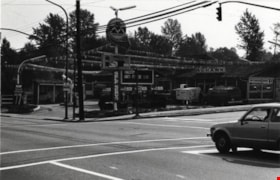
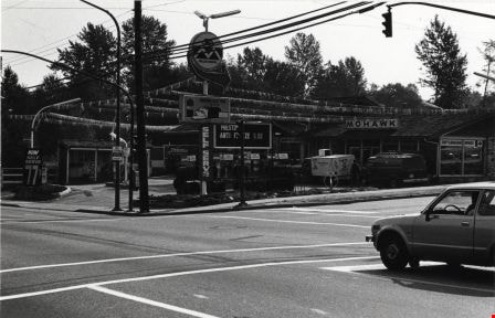
Mohawk Cascade Service Station
https://search.heritageburnaby.ca/link/archivedescription79263
- Repository
- City of Burnaby Archives
- Date
- September 27, 1976
- Collection/Fonds
- Burnaby Public Library Contemporary Visual Archive Project
- Description Level
- Item
- Physical Description
- 1 photograph : b&w ; 11 x 16 cm mounted on cardboard
- Scope and Content
- Photograph shows Mohawk Cascade Service Station at the corner of Canada Way and Smith Avenue.
- Repository
- City of Burnaby Archives
- Date
- September 27, 1976
- Collection/Fonds
- Burnaby Public Library Contemporary Visual Archive Project
- Physical Description
- 1 photograph : b&w ; 11 x 16 cm mounted on cardboard
- Description Level
- Item
- Record No.
- 556-227
- Access Restriction
- No restrictions
- Reproduction Restriction
- Reproduce for fair dealing purposes only
- Accession Number
- 2013-13
- Scope and Content
- Photograph shows Mohawk Cascade Service Station at the corner of Canada Way and Smith Avenue.
- Media Type
- Photograph
- Photographer
- Norton, Paul
- Notes
- Scope note taken directly from BPL photograph description.
- 1 b&w copy negative : 10 x 12.5 cm accompanying
- Geographic Access
- Canada Way
- Smith Avenue
- Historic Neighbourhood
- Broadview (Historic Neighbourhood)
- Planning Study Area
- Cascade-Schou Area
Images
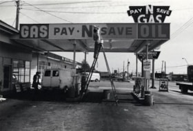
Pay-N-Save Gas Station
https://search.heritageburnaby.ca/link/archivedescription79265
- Repository
- City of Burnaby Archives
- Date
- September 10, 1976
- Collection/Fonds
- Burnaby Public Library Contemporary Visual Archive Project
- Description Level
- Item
- Physical Description
- 1 photograph : b&w ; 11 x 16 cm mounted on cardboard
- Scope and Content
- Photograph shows the Pay-N-Save Gas Station at 6105 Kingsway.
- Repository
- City of Burnaby Archives
- Date
- September 10, 1976
- Collection/Fonds
- Burnaby Public Library Contemporary Visual Archive Project
- Physical Description
- 1 photograph : b&w ; 11 x 16 cm mounted on cardboard
- Description Level
- Item
- Record No.
- 556-229
- Access Restriction
- No restrictions
- Reproduction Restriction
- Reproduce for fair dealing purposes only
- Accession Number
- 2013-13
- Scope and Content
- Photograph shows the Pay-N-Save Gas Station at 6105 Kingsway.
- Names
- Pay-N-Save Gas Station
- Media Type
- Photograph
- Photographer
- Norton, Paul
- Notes
- Scope note taken directly from BPL photograph description.
- 1 b&w copy negative : 10 x 12.5 cm accompanying
- Geographic Access
- Kingsway
- Street Address
- 6105 Kingsway
- Planning Study Area
- Windsor Area
Images
