More like 'C.F. Sprott's house'
Narrow Results By
Decade
- 2020s 105
- 2010s 49
- 2000s 493
- 1990s 409
- 1980s 413
- 1970s 1007
- 1960s 299
- 1950s 491
- 1940s 446
- 1930s 373
- 1920s
- 1910s 468
- 1900s 210
- 1890s 32
- 1880s 49
- 1870s 3
- 1860s 1
- 1850s 1
- 1840s 1
- 1830s 1
- 1820s 1
- 1810s 1
- 1800s 1
- 1790s 1
- 1780s 1
- 1770s 1
- 1760s 1
- 1750s 1
- 1740s 1
- 1730s 1
- 1720s 1
- 1710s 1
- 1700s 1
- 1690s 1
- 1680s 1
- 1670s 1
- 1660s 1
- 1650s 1
- 1640s 1
- 1630s 1
- 1620s 1
- 1610s 1
- 1600s 1

E.W. Bateman House 'Elworth'
https://search.heritageburnaby.ca/link/landmark538
- Repository
- Burnaby Heritage Planning
- Description
- The E.W. Bateman House is a one-and-one-half storey wood-frame residence set within in a garden landscape. The house and its adjacent garage are the only historic buildings standing on their original site within the Burnaby Village Museum property.
- Associated Dates
- 1922
- Formal Recognition
- Heritage Designation, Community Heritage Register
- Other Names
- Edwin & Mary Bateman Residence
- Street View URL
- Google Maps Street View
- Repository
- Burnaby Heritage Planning
- Other Names
- Edwin & Mary Bateman Residence
- Geographic Access
- Deer Lake Avenue
- Associated Dates
- 1922
- Formal Recognition
- Heritage Designation, Community Heritage Register
- Enactment Type
- Bylaw No. 9807
- Enactment Date
- 23/11/1992
- Description
- The E.W. Bateman House is a one-and-one-half storey wood-frame residence set within in a garden landscape. The house and its adjacent garage are the only historic buildings standing on their original site within the Burnaby Village Museum property.
- Heritage Value
- The E.W. Bateman House was constructed in the Deer Lake Crescent subdivision, that was originally promoted in 1911 as an upper class suburban neighbourhood. It represents one of the first residential developments in the City of Burnaby that required buildings to be of a specific value, thus demonstrating the desire for exclusivity among the successful businessmen who chose to settle in the area. The house and grounds illustrate the reduced scale of upper-class residential construction at a time of modest returning prosperity that followed the end of the First World War, and the social, cultural, lifestyle and leisure sensibilities of the owners in the Deer Lake Crescent subdivision: such values as social aspiration, racial exclusivity, demonstration of architectural taste, and importance of a landscaped garden. The heritage value of the E.W. Bateman House is its comprehensive representation of an upper middle-class suburban residence of the early 1920s. It was built for retired CPR executive Edwin Wettenhall Bateman (1859-1957) and his wife, Mary (Dale) Bateman (1865-1935), by contractor William Dodson in 1922. The Bateman House was designed by English-born and trained architect Enoch Evans (1862-1939) of E. Evans and Son, and is an important surviving residential design by Evans, and a typical example of the eclectic Period Revival influences that were common to domestic architecture in the post-First World War era. The symmetry of the imposing front verandah, supported by exaggerated Ionic columns, gives the relatively-modest house an image of grandeur and formality. Named after Edwin Bateman’s birthplace in Cheshire, England, ‘Elworth’ also symbolizes allegiance to England and the patriotic tenor of the time. The heritage value for this house also lies in its interpretive value within the Burnaby Village Museum. The site is an important cultural feature for the interpretation of Burnaby’s heritage to the public. The E.W. Bateman House was purchased by Burnaby in 1970 and became the focal point for the development of the Museum. Both the interior and exterior of the house have been restored and interpreted to the date of original construction, including recreated room interiors and period furnishings.
- Defining Elements
- The elements that define the heritage character of the E.W. Bateman House include its: - rectangular form and massing with central entry on long side - side gable roof with front shed dormer with cedar shingle cladding - symmetry of front facade - full open front verandah inset under the roofline, supported with Ionic columns - cedar shingle siding - multi-paned double-hung wooden-sash windows, mixture of 6-over-1 and 8-over-1 - symmetrical disposition of fenestration, with double-assembly units on the ground floor - exterior shutters - two flanking brick chimneys on the side elevations - interior room layouts and original interior features such as quality millwork and original hardware - original garage at the rear of the house
- Locality
- Deer Lake Park
- Historic Neighbourhood
- Burnaby Lake (Historic Neighbourhood)
- Planning Study Area
- Morley-Buckingham Area
- Organization
- Burnaby Village Museum
- Architect
- Enoch Evans
- E. Evans and Son
- Builder
- William Dodson
- Function
- Primary Current--Museum
- Primary Historic--Single Dwelling
- Community
- Burnaby
- Cadastral Identifier
- P.I.D. No. 011-030-356 Legal Description: Parcel 1, District Lot 79 and District Lot 85, Group 1, New Westminster District, Reference Plan 77594
- Boundaries
- Burnaby Village Museum is comprised of a single municipally-owned property located at 6501 Deer Lake Avenue, Burnaby.
- Area
- 38,488.63
- Contributing Resource
- Building
- Landscape Feature
- Structure
- Ownership
- Public (local)
- Documentation
- Heritage Site Files: PC77000 20. City of Burnaby Planning and Building Department, 4949 Canada Way, Burnaby, B.C., V5G 1M2
- Subjects
- Buildings - Residential
- Buildings - Residential - Houses
- Buildings - Heritage
- Buildings - Civic - Museums
- Street Address
- 6501 Deer Lake Avenue
- Street View URL
- Google Maps Street View
Images


Barnet Lumber Company House
https://search.heritageburnaby.ca/link/landmark662
- Repository
- Burnaby Heritage Planning
- Description
- Residential building.
- Associated Dates
- 1925
- Street View URL
- Google Maps Street View
- Repository
- Burnaby Heritage Planning
- Geographic Access
- Texaco Drive
- Associated Dates
- 1925
- Description
- Residential building.
- Heritage Value
- This house is one of two surviving houses built as a “Model Home” for the manager of the Barnet Lumber Company, which was the successor to the North Pacific Lumber Company. It was used as a combined home and office. It was constructed with framing lumber and millwork sawn at the mill. Typical of the Craftsman style, the house has a front gabled roof with triangular eave brackets. It has been altered with the addition of asbestos shingles over the original siding, but retains its form, scale and massing. This house was designed by the firm of Townley & Matheson. The partnership of Fred Laughton Townley (1887-1966) and Robert Michael Matheson began in 1919, and the firm left a rich legacy of sophisticated work, including schools, commercial structures, many fine residences and the landmark Vancouver City Hall.
- Historic Neighbourhood
- Barnet (Historic Neighbourhood)
- Planning Study Area
- Burnaby Mountain Area
- Architect
- Townley & Matheson
- Area
- 2225.77
- Contributing Resource
- Building
- Ownership
- Public (local)
- Street Address
- 8007 Texaco Drive
- Street View URL
- Google Maps Street View
Images


Barnet Lumber Company House
https://search.heritageburnaby.ca/link/landmark663
- Repository
- Burnaby Heritage Planning
- Description
- Residential building.
- Associated Dates
- 1925
- Street View URL
- Google Maps Street View
- Repository
- Burnaby Heritage Planning
- Geographic Access
- Texaco Drive
- Associated Dates
- 1925
- Description
- Residential building.
- Heritage Value
- This house is one of two surviving houses built as a “Model Home” for one of the assistant managers of the Barnet Lumber Company, using framing lumber and millwork sawn at the mill. This house was also designed by the firm of Townley & Matheson. The house was raised and renovated in 1997, resulting in alterations such as new dormers and elongated porch piers.
- Historic Neighbourhood
- Barnet (Historic Neighbourhood)
- Planning Study Area
- Burnaby Mountain Area
- Architect
- Townley & Matheson
- Contributing Resource
- Building
- Ownership
- Private
- Street Address
- 8039 Texaco Drive
- Street View URL
- Google Maps Street View
Images


Capitol Hill School
https://search.heritageburnaby.ca/link/landmark564
- Repository
- Burnaby Heritage Planning
- Description
- School building.
- Associated Dates
- 1923
- Other Names
- Ecole Capitol Hill Elementary School
- Street View URL
- Google Maps Street View
- Repository
- Burnaby Heritage Planning
- Other Names
- Ecole Capitol Hill Elementary School
- Geographic Access
- Holdom Avenue
- Associated Dates
- 1923
- Description
- School building.
- Heritage Value
- This school was originally designed by Bowman & Cullerne as a two-storey, four-room school building in 1923, with a two-room addition completed in 1926 and another in 1927. Originally designed in the Arts and Crafts style, it has been altered, with the addition of stucco over the original siding and replacement windows, but has retained its original form and massing, as well as its roof-top ventilator and front gabled entrance with grouped columns. Bowman & Cullerne specialized in school design. After Harold Cullerne (1890-1976) returned from service during the First World War, he joined J.H. Bowman (1864-1943) in a partnership that lasted from 1919 to 1934. The firm’s other school designs included Seaforth School (1922, now relocated to Burnaby Village Museum), Burnaby North High School (1923), and Nelson Avenue School (1927).
- Locality
- Capitol Hill
- Historic Neighbourhood
- Capitol Hill (Historic Neighbourhood)
- Planning Study Area
- Capitol Hill Area
- Architect
- Bowman & Cullerne
- Ownership
- Public (local)
- Subjects
- Buildings - Heritage
- Buildings - Schools
- Street Address
- 350 Holdom Avenue
- Street View URL
- Google Maps Street View
Images


Douglas Road School
https://search.heritageburnaby.ca/link/landmark573
- Repository
- Burnaby Heritage Planning
- Description
- School building.
- Associated Dates
- 1928
- Other Names
- Douglas Road Elementary School
- Street View URL
- Google Maps Street View
- Repository
- Burnaby Heritage Planning
- Other Names
- Douglas Road Elementary School
- Geographic Access
- Canada Way
- Associated Dates
- 1928
- Description
- School building.
- Heritage Value
- The Douglas Road School was originally established as a two-room school in 1908 on this site, and later expanded to four classrooms. Anticipating rapid settlement of this district, the School Board purchased two acres adjoining the old building. Two of the four rooms were designed to become one large auditorium suitable for special events and public gatherings, with seating for two hundred people. The classically-influenced school has been altered with new windows and extended with additional wings, but has retained its original red-brick veneer, tan-brick quoins and bellcast octagonal roof ventilator. Designed by McCarter & Nairne, the school was built by contractor A.S. Perry. McCarter & Nairne, who also designed the Second Street School, were the Burnaby School Board architects at this time. John Y. McCarter (1886-1981) and George Nairne (1884-1953) formed their partnership in 1921 after serving overseas during the First World War. The partners began designing houses and small apartment buildings, and their commissions included Vancouver’s first skyscraper, the Marine Building (1928-30).
- Locality
- Burnaby Lake
- Historic Neighbourhood
- Burnaby Lake (Historic Neighbourhood)
- Planning Study Area
- Douglas-Gilpin Area
- Architect
- McCarter & Nairne
- Subjects
- Buildings - Heritage
- Buildings - Schools
- Street Address
- 4861 Canada Way
- Street View URL
- Google Maps Street View
Images


Cram family fruit stand
https://search.heritageburnaby.ca/link/archivedescription35703
- Repository
- City of Burnaby Archives
- Date
- 1920 (date of original), copied 1986
- Collection/Fonds
- Burnaby Historical Society fonds
- Description Level
- Item
- Physical Description
- 1 photograph : b&w ; 12.7 x 17.8 cm print
- Scope and Content
- Photograph of the Cram roadside fruit stand on Kingsway with Mary Cram in front. The Cram family sold fruit, produce, honey, and cottage cheese from their farm at Kingsway and what is now 6515 Denbigh Avenue. The stand was located directly in front of the Cram-Tidball family home.
- Repository
- City of Burnaby Archives
- Date
- 1920 (date of original), copied 1986
- Collection/Fonds
- Burnaby Historical Society fonds
- Subseries
- Pioneer Tales subseries
- Physical Description
- 1 photograph : b&w ; 12.7 x 17.8 cm print
- Description Level
- Item
- Record No.
- 204-561
- Access Restriction
- No restrictions
- Reproduction Restriction
- No known restrictions
- Accession Number
- BHS1988-03
- Scope and Content
- Photograph of the Cram roadside fruit stand on Kingsway with Mary Cram in front. The Cram family sold fruit, produce, honey, and cottage cheese from their farm at Kingsway and what is now 6515 Denbigh Avenue. The stand was located directly in front of the Cram-Tidball family home.
- Names
- Vogt, Mary Cram
- Media Type
- Photograph
- Notes
- Title based on contents of photograph
- Geographic Access
- Denbigh Avenue
- Street Address
- 6515 Denbigh Avenue
- Historic Neighbourhood
- Central Park (Historic Neighbourhood)
- Planning Study Area
- Windsor Area
Images


Price Strawberry farm
https://search.heritageburnaby.ca/link/archivedescription35946
- Repository
- City of Burnaby Archives
- Date
- 1920 (date of original), copied 1986
- Collection/Fonds
- Burnaby Historical Society fonds
- Description Level
- Item
- Physical Description
- 1 photograph : b&w ; 7.6 x 12.7 cm print
- Scope and Content
- Photograph of the Price Strawberry farm at 5220 Royal Oak Avenue. Oakalla Prison Farm can be seen in the background.
- Repository
- City of Burnaby Archives
- Date
- 1920 (date of original), copied 1986
- Collection/Fonds
- Burnaby Historical Society fonds
- Subseries
- Pioneer Tales subseries
- Physical Description
- 1 photograph : b&w ; 7.6 x 12.7 cm print
- Description Level
- Item
- Record No.
- 204-806
- Access Restriction
- No restrictions
- Reproduction Restriction
- No known restrictions
- Accession Number
- BHS1988-03
- Scope and Content
- Photograph of the Price Strawberry farm at 5220 Royal Oak Avenue. Oakalla Prison Farm can be seen in the background.
- Names
- Oakalla Prison Farm
- Media Type
- Photograph
- Notes
- Title based on contents of photograph
- Geographic Access
- Oakmount Crescent
- Street Address
- 5220 Oakmount Crescent
- Historic Neighbourhood
- Burnaby Lake (Historic Neighbourhood)
- Planning Study Area
- Oakalla Area
Images

Agricultural Exhibit
https://search.heritageburnaby.ca/link/archivedescription34526
- Repository
- City of Burnaby Archives
- Date
- 1925
- Collection/Fonds
- Burnaby Historical Society fonds
- Description Level
- Item
- Physical Description
- 1 photograph : b&w ; 20.4 x 25.3 cm
- Scope and Content
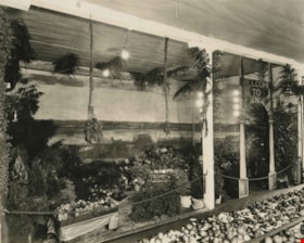
- Photograph of Burnaby's Agricultural Exhibit at New Westminster. Vegetables, fruit, plants, flowers, and trees are on display inside a building. There is electric lighting. A sign on the right is shaped like an arch and reads, "Welcome to Burnaby." A mural showing Burnaby Lake is behind the dis…
- Repository
- City of Burnaby Archives
- Date
- 1925
- Collection/Fonds
- Burnaby Historical Society fonds
- Subseries
- Photographs subseries
- Physical Description
- 1 photograph : b&w ; 20.4 x 25.3 cm
- Description Level
- Item
- Record No.
- 038-001
- Access Restriction
- No restrictions
- Reproduction Restriction
- No known restrictions
- Accession Number
- BHS2007-04
- Scope and Content
- Photograph of Burnaby's Agricultural Exhibit at New Westminster. Vegetables, fruit, plants, flowers, and trees are on display inside a building. There is electric lighting. A sign on the right is shaped like an arch and reads, "Welcome to Burnaby." A mural showing Burnaby Lake is behind the display.
- Subjects
- Agriculture - Crops
- Exhibitions - Agricultural
- Agriculture - Fruit and Berries
- Plants - Flowers
- Media Type
- Photograph
- Notes
- Title based on contents of photograph
Images

![Agricultural Exhibit, [1920] thumbnail](/media/hpo/_Data/_Archives_Images/_Unrestricted/001/039-001.jpg?width=280)
Agricultural Exhibit
https://search.heritageburnaby.ca/link/archivedescription34527
- Repository
- City of Burnaby Archives
- Date
- [1920]
- Collection/Fonds
- Burnaby Historical Society fonds
- Description Level
- Item
- Physical Description
- 1 photograph : b&w ; 20.4 x 25.3 cm
- Scope and Content
- Photograph of Burnaby's Agricultural Exhibit at New Westminster. Vegetables, fruit, preserves, flowers, and plants are on display inside a building. There is electric lighting. A sign above the display reads, "Burnaby." A sign above a container on the lower left reads, "Ginseng / Grown in Lozel…
- Repository
- City of Burnaby Archives
- Date
- [1920]
- Collection/Fonds
- Burnaby Historical Society fonds
- Subseries
- Photographs subseries
- Physical Description
- 1 photograph : b&w ; 20.4 x 25.3 cm
- Description Level
- Item
- Record No.
- 039-001
- Access Restriction
- No restrictions
- Reproduction Restriction
- No known restrictions
- Accession Number
- BHS2007-04
- Scope and Content
- Photograph of Burnaby's Agricultural Exhibit at New Westminster. Vegetables, fruit, preserves, flowers, and plants are on display inside a building. There is electric lighting. A sign above the display reads, "Burnaby." A sign above a container on the lower left reads, "Ginseng / Grown in Lozells District by Mr. Romer."
- Subjects
- Agriculture - Crops
- Exhibitions - Agricultural
- Agriculture - Fruit and Berries
- Plants - Flowers
- Media Type
- Photograph
- Notes
- Title based on contents of photograph
Images
![Agricultural Exhibit, [1920] thumbnail](/media/hpo/_Data/_Archives_Images/_Unrestricted/001/039-001.jpg)
Agricultural Exhibit
https://search.heritageburnaby.ca/link/archivedescription34528
- Repository
- City of Burnaby Archives
- Date
- 1921
- Collection/Fonds
- Burnaby Historical Society fonds
- Description Level
- Item
- Physical Description
- 1 photograph : b&w ; 20.4 x 25.4 cm
- Scope and Content
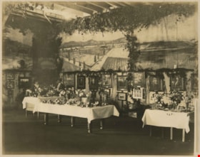
- Photograph of Burnaby's Agricultural Exhibit at New Westminster. Tables with fruit, vegetables and flowers are displayed. Greenery and photographs (mainly of people) are on the walls, including a portrait of former Reeve Nicolai C. Schou (second portrait from right). A sign in the corner reads, …
- Repository
- City of Burnaby Archives
- Date
- 1921
- Collection/Fonds
- Burnaby Historical Society fonds
- Subseries
- Photographs subseries
- Physical Description
- 1 photograph : b&w ; 20.4 x 25.4 cm
- Description Level
- Item
- Record No.
- 040-001
- Access Restriction
- No restrictions
- Reproduction Restriction
- No known restrictions
- Accession Number
- BHS2007-04
- Scope and Content
- Photograph of Burnaby's Agricultural Exhibit at New Westminster. Tables with fruit, vegetables and flowers are displayed. Greenery and photographs (mainly of people) are on the walls, including a portrait of former Reeve Nicolai C. Schou (second portrait from right). A sign in the corner reads, "Burnaby's Exhibit," and a mural hangs on the walls above the exhibit. A woman and man are standing behind a table at the back left.
- Subjects
- Agriculture - Crops
- Exhibitions - Agricultural
- Agriculture - Fruit and Berries
- Plants - Flowers
- Documentary Artifacts - Photographs
- Media Type
- Photograph
Images

![Burnaby Agricultural Exhibition, [1920] thumbnail](/media/hpo/_Data/_Archives_Images/_Unrestricted/001/040-002.jpg?width=280)
Burnaby Agricultural Exhibition
https://search.heritageburnaby.ca/link/archivedescription34529
- Repository
- City of Burnaby Archives
- Date
- [1920]
- Collection/Fonds
- Burnaby Historical Society fonds
- Description Level
- Item
- Physical Description
- 1 photograph : b&w ; 20.5 x 25.5 cm
- Scope and Content
- Photograph of Burnaby's Agricultural Exhibit at New Westminster. Fruits, vegetables and flowers are displayed on tables. Greenery and photographs (mainly of people) are on the walls, including a portrait of former Reeve Nicolai C. Schou (second portrait from right). A sign in the corner reads, "…
- Repository
- City of Burnaby Archives
- Date
- [1920]
- Collection/Fonds
- Burnaby Historical Society fonds
- Subseries
- Photographs subseries
- Physical Description
- 1 photograph : b&w ; 20.5 x 25.5 cm
- Description Level
- Item
- Record No.
- 040-002
- Access Restriction
- No restrictions
- Reproduction Restriction
- No known restrictions
- Accession Number
- BHS2007-04
- Scope and Content
- Photograph of Burnaby's Agricultural Exhibit at New Westminster. Fruits, vegetables and flowers are displayed on tables. Greenery and photographs (mainly of people) are on the walls, including a portrait of former Reeve Nicolai C. Schou (second portrait from right). A sign in the corner reads, "Burnaby's Exhibit," and a mural hangs on the walls above the exhibit. Two men are standing behind a table in the centre.
- Subjects
- Agriculture - Crops
- Exhibitions - Agricultural
- Agriculture - Fruit and Berries
- Plants - Flowers
- Documentary Artifacts - Photographs
- Media Type
- Photograph
- Notes
- Title based on contents of photograph
Images
![Burnaby Agricultural Exhibition, [1920] thumbnail](/media/hpo/_Data/_Archives_Images/_Unrestricted/001/040-002.jpg)
![Elgin Avenue farmhouse, [between 1920 and 1925] (date of original), copied 1986 thumbnail](/media/hpo/_Data/_Archives_Images/_Unrestricted/126/179-005.jpg?width=280)
Elgin Avenue farmhouse
https://search.heritageburnaby.ca/link/archivedescription35034
- Repository
- City of Burnaby Archives
- Date
- [between 1920 and 1925] (date of original), copied 1986
- Collection/Fonds
- Burnaby Historical Society fonds
- Description Level
- Item
- Physical Description
- 1 photograph : b&w ; 8.7 x 12.7 cm print
- Scope and Content
- Photograph of the exterior of an Elgin Avenue farmhouse and surrounding property. The farmhouse is at the left side of the photograph, and a chicken barn is at the right side. This may be 6389 Elgin Avenue.
- Repository
- City of Burnaby Archives
- Date
- [between 1920 and 1925] (date of original), copied 1986
- Collection/Fonds
- Burnaby Historical Society fonds
- Subseries
- Chamberlain family subseries
- Physical Description
- 1 photograph : b&w ; 8.7 x 12.7 cm print
- Description Level
- Item
- Record No.
- 179-005
- Access Restriction
- No restrictions
- Reproduction Restriction
- No known restrictions
- Accession Number
- BHS1986-27
- Scope and Content
- Photograph of the exterior of an Elgin Avenue farmhouse and surrounding property. The farmhouse is at the left side of the photograph, and a chicken barn is at the right side. This may be 6389 Elgin Avenue.
- Media Type
- Photograph
- Notes
- Title based on contents of photograph
- Geographic Access
- Elgin Avenue
- Street Address
- 6389 Elgin Avenue
- Historic Neighbourhood
- Central Park (Historic Neighbourhood)
- Planning Study Area
- Windsor Area
Images
![Elgin Avenue farmhouse, [between 1920 and 1925] (date of original), copied 1986 thumbnail](/media/hpo/_Data/_Archives_Images/_Unrestricted/126/179-005.jpg)
![Nicholson farm, [1921] thumbnail](/media/hpo/_Data/_Archives_Images/_Unrestricted/371/375-003.jpg?width=280)
Nicholson farm
https://search.heritageburnaby.ca/link/archivedescription38242
- Repository
- City of Burnaby Archives
- Date
- [1921]
- Collection/Fonds
- Burnaby Historical Society fonds
- Description Level
- Item
- Physical Description
- 1 photograph : b&w ; 9 x 12.5 cm
- Scope and Content
- Photograph of four men standing alongside a team of horses working in the field at the farm belonging to E.W. Nicholson. The house and barns can be seen in the background.
- Repository
- City of Burnaby Archives
- Date
- [1921]
- Collection/Fonds
- Burnaby Historical Society fonds
- Subseries
- Margaret McCallum subseries
- Physical Description
- 1 photograph : b&w ; 9 x 12.5 cm
- Description Level
- Item
- Record No.
- 375-003
- Access Restriction
- No restrictions
- Reproduction Restriction
- No known restrictions
- Accession Number
- BHS1986-42
- Scope and Content
- Photograph of four men standing alongside a team of horses working in the field at the farm belonging to E.W. Nicholson. The house and barns can be seen in the background.
- Media Type
- Photograph
- Notes
- Title based on contents of photograph
- Geographic Access
- Boundary Road
- Street Address
- 2550 Boundary Road
- Historic Neighbourhood
- Broadview (Historic Neighbourhood)
- Planning Study Area
- West Central Valley Area
Images
![Nicholson farm, [1921] thumbnail](/media/hpo/_Data/_Archives_Images/_Unrestricted/371/375-003.jpg)
![Frank and Bill Price eating raspberries, [192-] (date of original), copied 1992 thumbnail](/media/hpo/_Data/_Archives_Images/_Unrestricted/315/315-447.jpg?width=280)
Frank and Bill Price eating raspberries
https://search.heritageburnaby.ca/link/archivedescription36989
- Repository
- City of Burnaby Archives
- Date
- [192-] (date of original), copied 1992
- Collection/Fonds
- Burnaby Historical Society fonds
- Description Level
- Item
- Physical Description
- 1 photograph : b&w ; 5.8 x 8.2 cm print
- Scope and Content
- Photograph of father and son, Frank and William "Bill" Price, eating raspberries while picking them at their family property on Royal Oak Avenue at Oakland Street, in the area north of Kingsway.
- Repository
- City of Burnaby Archives
- Date
- [192-] (date of original), copied 1992
- Collection/Fonds
- Burnaby Historical Society fonds
- Subseries
- Burnaby Centennial Anthology subseries
- Physical Description
- 1 photograph : b&w ; 5.8 x 8.2 cm print
- Description Level
- Item
- Record No.
- 315-447
- Access Restriction
- No restrictions
- Reproduction Restriction
- No known restrictions
- Accession Number
- BHS1994-04
- Scope and Content
- Photograph of father and son, Frank and William "Bill" Price, eating raspberries while picking them at their family property on Royal Oak Avenue at Oakland Street, in the area north of Kingsway.
- Media Type
- Photograph
- Notes
- Title based on contents of photograph
- Geographic Access
- Royal Oak Avenue
- Oakland Street
- Historic Neighbourhood
- Central Park (Historic Neighbourhood)
- Planning Study Area
- Marlborough Area
Images
![Frank and Bill Price eating raspberries, [192-] (date of original), copied 1992 thumbnail](/media/hpo/_Data/_Archives_Images/_Unrestricted/315/315-447.jpg)

Murdock and Lillian McMurray interview November 17, 1975 - Track 2
https://search.heritageburnaby.ca/link/oralhistory244
- Repository
- City of Burnaby Archives
- Date Range
- 1906-1975
- Length
- 0:09:00
- Summary
- This portion of the recording pertains to Murdock McMurray's memories of riding the tram as a young man and briefly, of working for Ed Brown. Murdock mentions Reeve Byrne and the development of first water system in Burnaby. He also discusses Gilley Brother's Logging Company practices near his fath…
- Repository
- City of Burnaby Archives
- Summary
- This portion of the recording pertains to Murdock McMurray's memories of riding the tram as a young man and briefly, of working for Ed Brown. Murdock mentions Reeve Byrne and the development of first water system in Burnaby. He also discusses Gilley Brother's Logging Company practices near his father's ranch of six acres, which grew mostly strawberries to sell in Vancouver.
- Date Range
- 1906-1975
- Photo Info
- Emerson Doran (left) and Murdoch McMurray, 1917. Item no. 229-004
- Length
- 0:09:00
- Subjects
- Agriculture - Fruit and Berries
- Geographic Access
- Imperial Street
- Historic Neighbourhood
- Edmonds (Historic Neighbourhood)
- Planning Study Area
- Kingsway-Beresford Area
- Interviewer
- McGeachie, Doreen “Pixie”
- Interview Date
- November 17, 1975
- Scope and Content
- Recording is of an interview with Murdock McMurray and his wife Lillian (Wray) McMurray conducted by Pixie McGeachie on November 17, 1975. Major themes discussed are: Burnaby's development, the Wray Shoe store and Murdock McMurray's cordwood delivery business.
- Biographical Notes
- Murdock McMurray was born in Vancouver in 1892 to Wilhelmina May and Robert William McMurray. Other children in the family included older siblings John “Jack” and Margaret Lillian, younger siblings Minnie May born May 4, 1895 and Hampton born June 8, 1902. Murdock’s father Robert worked for the Canadian Pacific Railway (CPR) but retired shortly after moving his family to Burnaby in 1906. He bought six acres of land of what had been previously the Gilley Ranch, the base of operations for Gilley Bros. Ltd. at 2519 Windsor Street (later renumbered and renamed to the 6400 block Imperial Street). Murdock McMurray quit school early to apprentice as a printer. By sixteen he had left the trade and gone into partnership with his older brother Jack. With a team of horses, harness and a wagon, the brothers helped to macadamize roads, haul building supplies for new homes, deliver cord wood for heating, clear land and excavate basements. When Jack McMurray set off to serve overseas during World War I as a driver in the engineer corps, Murdock bought his team of horses and continued working, mainly in the Deer Lake district. In 1916 Murdoch McMurray partnered with Emerson Doran, nephew of the owner of Doran's Mill to buy Edmonds Coal and Wood fuel yard. As everything was geared towards the war effort, Murdock and Emerson soon ran out of work and had to sell the business. Murdock sold off his horses and equipment and went to work at the ship yard on Pitt River. By 1919 Jack McMurray had returned home from overseas and was working as a fireman at the Shull Lumber and Shingle Mill on the Fraser River. In 1921, he and Murdock teamed up with Emerson Doran and repurchased the Edmonds Coal and Wood fuel yard which they ran together until 1947. Murdock McMurray married Lillian Wray on September 17, 1925. Lillian was the daughter of Mr. and Mrs. Edward Wray, who came to settle in the Jubilee area of Burnaby in 1919. The family lived on Dow Road and Edward Wray operated Jubilee Shoe Store and Post Office. He was known throughout the district as "Wray - The Shoe Man." Mrs. Wray died in 1957 at the age of eight-six and Edward Wray died January 14, 1967 at age of ninety-three. Murdock and Lillian lived at Inverness Street (now Arcola) and raised three children together, Bob, Jack and Bessie. Murdock McMurray died in New Westminster on April 28, 1985 at the age of ninety-two. Lillian Ethel (Wray) McMurray died in Burnaby on February 28, 1986 at the age of eighty-seven.
- Total Tracks
- 7
- Total Length
- 0:58:55
- Interviewee Name
- McMurray, Lillian Wray
- McMurray, Murdoch
- Interviewer Bio
- Doreen "Pixie" (Johnson) McGeachie was a resident of Burnaby for over sixty years. Pixie married John Aloysius "Jack" McGeachie and raised their children Kathi (Dunlop) and David McGeachie in the house the couple built themselves in 1947. Pixie served as the editor for the Burnaby Examiner newspaper and wrote a column entitled "Burnaby History" for The News. In 1974 she authored her first book titled "Bygones of Burnaby" which was one of the first to develop anecdotal stories about pioneer life in Burnaby. She authored "Burnaby - A Proud Century" in 1992 and in 2002 she wrote a biography of the city's namesake in the book "Land of Promise: Robert Burnaby's letters from Colonial B.C." She also contributed many hours of volunteering; helping to establish Burnaby's first museum Heritage Village in 1971, serving as President of the Burnaby Historical Society from 1991-1993. She served a six year term on Burnaby's Heritage Commission leading the charge to preserve many historic sites throughout the city, and during her twenty years as the Community Archives volunteer archivist for the historical society, she succeeded in gathering thousands of rare and valuable historic photographs and documents which now forms the core of the photograph collection on the Heritage Burnaby website (as these items were donated by the Society to the City Archives in 2007). The City of Burnaby awarded Pixie McGeachie the Kushiro Cup as Citizen of the year in 2002. In 2006 she received a Heritage BC project award for leading the Friends of Interurban 1223 project, and in 2008 Heritage BC recognised her again by presenting her with the Ruby Nobb Award. John Aloysius "Jack" McGeachie died October 12, 1981 at the age of sixty-seven. Doreen "Pixie" (Johnson) McGeachie died August 14, 2010 at the age of eighty-nine. On 24 September, 2011, the City of Burnaby dedicated the reading at the City Archives in honour of Pixie and formally named it the Pixie McGeachie Reading Room in recognition of her years of service to the community.
- Collection/Fonds
- Burnaby Historical Society fonds
- Subseries
- Oral history subseries
- Media Type
- Sound Recording
- Web Notes
- Interview was digitized in 2010 allowing it to be accessible on Heritage Burnaby. The digitization project was initiated by the Community Heritage Commission with support from City of Burnaby Council and the BC History Digitization Program of the Irving K. Barber Learning Centre, University of British Columbia. It was recognized by the Heritage Society of BC with an award in 2012.
Images

Audio Tracks
Track two of recording of interview with Lillian and Murdock McMurray
Track two of recording of interview with Lillian and Murdock McMurray
https://search.heritageburnaby.ca/media/hpo/_Data/_Archives_Oral_Histories/_Unrestricted/MSS137-010/MSS137-010_Track_2.mp3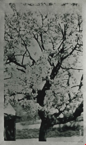
Royal Anne cherry tree
https://search.heritageburnaby.ca/link/archivedescription35559
- Repository
- City of Burnaby Archives
- Date
- 1920 (date of original), copied 1986
- Collection/Fonds
- Burnaby Historical Society fonds
- Description Level
- Item
- Physical Description
- 1 photograph : b&w ; 12.7 x 17.8 cm print
- Scope and Content
- Photograph of a Royal Anne cherry tree in the backyard of the Cram orchard at 6515 Denbigh Avenue, on the northwest corner of Kingsway and Denbigh. The garage can be seen on the left. William Cram (father) would pick the cherries, and Mary Cram and Viola Cram (sisters) would load them in a wagon …
- Repository
- City of Burnaby Archives
- Date
- 1920 (date of original), copied 1986
- Collection/Fonds
- Burnaby Historical Society fonds
- Subseries
- Pioneer Tales subseries
- Physical Description
- 1 photograph : b&w ; 12.7 x 17.8 cm print
- Description Level
- Item
- Record No.
- 204-417
- Access Restriction
- No restrictions
- Reproduction Restriction
- No known restrictions
- Accession Number
- BHS1988-03
- Scope and Content
- Photograph of a Royal Anne cherry tree in the backyard of the Cram orchard at 6515 Denbigh Avenue, on the northwest corner of Kingsway and Denbigh. The garage can be seen on the left. William Cram (father) would pick the cherries, and Mary Cram and Viola Cram (sisters) would load them in a wagon and sell them, a chore which they did not like.
- Media Type
- Photograph
- Notes
- Title based on contents of photograph
- Geographic Access
- Denbigh Avenue
- Street Address
- 6515 Denbigh Avenue
- Historic Neighbourhood
- Central Park (Historic Neighbourhood)
- Planning Study Area
- Windsor Area
Images

Boberg family home and farm
https://search.heritageburnaby.ca/link/archivedescription35772
- Repository
- City of Burnaby Archives
- Date
- 1924
- Collection/Fonds
- Burnaby Historical Society fonds
- Description Level
- Item
- Physical Description
- 1 photograph : b&w ; 12.7 x 17.8 cm print
- Scope and Content
- Photograph of the Boberg family home and farm on Douglas Road. Shown on the back porch, John Boberg (father) and Elin Boberg (mother) holding their only son, John, then 3 years old (born 1921).
- Repository
- City of Burnaby Archives
- Date
- 1924
- Collection/Fonds
- Burnaby Historical Society fonds
- Subseries
- Pioneer Tales subseries
- Physical Description
- 1 photograph : b&w ; 12.7 x 17.8 cm print
- Description Level
- Item
- Record No.
- 204-630
- Access Restriction
- No restrictions
- Reproduction Restriction
- No known restrictions
- Accession Number
- BHS1988-03
- Scope and Content
- Photograph of the Boberg family home and farm on Douglas Road. Shown on the back porch, John Boberg (father) and Elin Boberg (mother) holding their only son, John, then 3 years old (born 1921).
- Media Type
- Photograph
- Notes
- Title based on contents of photograph
- Historic Neighbourhood
- Burnaby Lake (Historic Neighbourhood)
- Planning Study Area
- Ardingley-Sprott Area
Images

![Keel farm house, [192-] thumbnail](/media/hpo/_Data/_Archives_Images/_Unrestricted/251/279-001.jpg?width=280)
Keel farm house
https://search.heritageburnaby.ca/link/archivedescription36488
- Repository
- City of Burnaby Archives
- Date
- [192-]
- Collection/Fonds
- Burnaby Historical Society fonds
- Description Level
- Item
- Physical Description
- 1 photograph : b&w ; 8.5 x 12.5 cm print
- Scope and Content
- Photograph of the A.J. Keel farm house and orchard, at 5387 Rumble Street. A.J. Keel bought this property, which went from Rumble to Walting, in 1920.
- Repository
- City of Burnaby Archives
- Date
- [192-]
- Collection/Fonds
- Burnaby Historical Society fonds
- Subseries
- Keel family subseries
- Physical Description
- 1 photograph : b&w ; 8.5 x 12.5 cm print
- Description Level
- Item
- Record No.
- 279-001
- Access Restriction
- No restrictions
- Reproduction Restriction
- No known restrictions
- Accession Number
- BHS1992-09
- Scope and Content
- Photograph of the A.J. Keel farm house and orchard, at 5387 Rumble Street. A.J. Keel bought this property, which went from Rumble to Walting, in 1920.
- Media Type
- Photograph
- Notes
- Title based on contents of photograph
- Geographic Access
- Rumble Street
- Street Address
- 5387 Rumble Street
- Historic Neighbourhood
- Alta-Vista (Historic Neighbourhood)
- Planning Study Area
- Clinton-Glenwood Area
Images
![Keel farm house, [192-] thumbnail](/media/hpo/_Data/_Archives_Images/_Unrestricted/251/279-001.jpg)
![McKenzie family home and farm, [192-?] (date of original), copied 1992 thumbnail](/media/hpo/_Data/_Archives_Images/_Unrestricted/315/315-505.jpg?width=280)
McKenzie family home and farm
https://search.heritageburnaby.ca/link/archivedescription37042
- Repository
- City of Burnaby Archives
- Date
- [192-?] (date of original), copied 1992
- Collection/Fonds
- Burnaby Historical Society fonds
- Description Level
- Item
- Physical Description
- 1 photograph : b&w ; 8.8 x 12.7 cm print
- Scope and Content
- Photograph of the McKenzie family home and farm on Laurier Street (now Halligan Street).
- Repository
- City of Burnaby Archives
- Date
- [192-?] (date of original), copied 1992
- Collection/Fonds
- Burnaby Historical Society fonds
- Subseries
- Burnaby Centennial Anthology subseries
- Physical Description
- 1 photograph : b&w ; 8.8 x 12.7 cm print
- Description Level
- Item
- Record No.
- 315-505
- Access Restriction
- No restrictions
- Reproduction Restriction
- No known restrictions
- Accession Number
- BHS1994-04
- Scope and Content
- Photograph of the McKenzie family home and farm on Laurier Street (now Halligan Street).
- Media Type
- Photograph
- Notes
- Title based on contents of photograph
- Geographic Access
- Halligan Street
- Historic Neighbourhood
- Edmonds (Historic Neighbourhood)
- Planning Study Area
- Morley-Buckingham Area
Images
![McKenzie family home and farm, [192-?] (date of original), copied 1992 thumbnail](/media/hpo/_Data/_Archives_Images/_Unrestricted/315/315-505.jpg)

Farrington Chicken Ranch
https://search.heritageburnaby.ca/link/archivedescription35226
- Repository
- City of Burnaby Archives
- Date
- 1920 (date of original), copied 1986
- Collection/Fonds
- Burnaby Historical Society fonds
- Description Level
- Item
- Physical Description
- 1 photograph : b&w ; 12.7 x 17.8 cm print
- Scope and Content
- Photograph of the Farrington brothers' chicken ranch near Central Park at 3907 Chesham Avenue (later renumbered 5384 Chesham Avenue). Brothers Thomas Farrington and Richard Farrington founded Wheat Sheaf Poultry Ranch in 1919. The laying house is at the left, and the family home is at the right.
- Repository
- City of Burnaby Archives
- Date
- 1920 (date of original), copied 1986
- Collection/Fonds
- Burnaby Historical Society fonds
- Subseries
- Pioneer Tales subseries
- Physical Description
- 1 photograph : b&w ; 12.7 x 17.8 cm print
- Description Level
- Item
- Record No.
- 204-083
- Access Restriction
- No restrictions
- Reproduction Restriction
- No known restrictions
- Accession Number
- BHS1988-03
- Scope and Content
- Photograph of the Farrington brothers' chicken ranch near Central Park at 3907 Chesham Avenue (later renumbered 5384 Chesham Avenue). Brothers Thomas Farrington and Richard Farrington founded Wheat Sheaf Poultry Ranch in 1919. The laying house is at the left, and the family home is at the right.
- Subjects
- Buildings - Agricultural
- Animals - Poultry
- Agriculture - Poultry
- Buildings - Residential - Houses
- Media Type
- Photograph
- Notes
- Title based on contents of photograph
- Geographic Access
- Chesham Avenue
- Street Address
- 5384 Chesham Avenue
- Historic Neighbourhood
- Central Park (Historic Neighbourhood)
- Planning Study Area
- Garden Village Area
Images
