Narrow Results By
Subject
- Advertising Medium 1
- Advertising Medium - Signs and Signboards 2
- Agriculture 2
- Agriculture - Farms 2
- Agriculture - Ranches 1
- Animals - Pigs 1
- Arts - Drawings 2
- Buildings 2
- Buildings - Civic - Community Centres 1
- Buildings - Civic - Seniors Centres 1
- Buildings - Commercial 1
- Buildings - Commercial - Grocery Stores 1
Rob Wilkins
https://search.heritageburnaby.ca/link/archivedescription79772
- Repository
- City of Burnaby Archives
- Date
- December 11, 1996
- Collection/Fonds
- Burnaby NewsLeader photograph collection
- Description Level
- Item
- Physical Description
- 1 photograph : b&w ; 16.5 x 11 cm
- Scope and Content
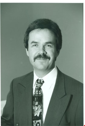
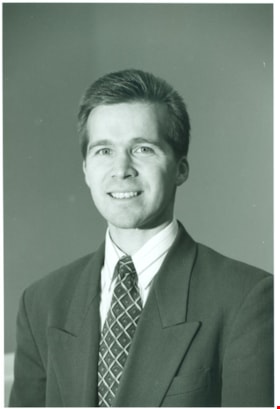
- Photograph of Rob Wilkins, Commercial Account manager at the Kingsway and Wilson Scotiabank location.
- Repository
- City of Burnaby Archives
- Date
- December 11, 1996
- Collection/Fonds
- Burnaby NewsLeader photograph collection
- Physical Description
- 1 photograph : b&w ; 16.5 x 11 cm
- Description Level
- Item
- Record No.
- 535-0514
- Access Restriction
- No restrictions
- Reproduction Restriction
- No reproduction permitted
- Accession Number
- 2012-11
- Scope and Content
- Photograph of Rob Wilkins, Commercial Account manager at the Kingsway and Wilson Scotiabank location.
- Names
- Wilkins, Rob
- Media Type
- Photograph
- Notes
- Title based on contents of photograph
- Note in black ink on recto of photograph reads: "Rob 22% Scotia / Bby #3 2927 B - 3"
- Trim marks and/or reproduction instructions on recto (scan is cropped)
Images

Scotiabank
https://search.heritageburnaby.ca/link/archivedescription79766
- Repository
- City of Burnaby Archives
- Date
- December 11, 1996
- Collection/Fonds
- Burnaby NewsLeader photograph collection
- Description Level
- Item
- Physical Description
- 1 photograph : b&w ; 16.5 x 24.5 cm
- Scope and Content
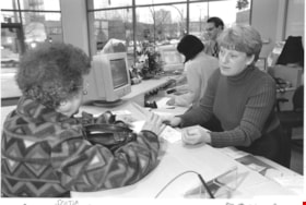
- Photograph of a customer being helped by an associate at the Kingsway and Wilson Scotiabank location.
- Repository
- City of Burnaby Archives
- Date
- December 11, 1996
- Collection/Fonds
- Burnaby NewsLeader photograph collection
- Physical Description
- 1 photograph : b&w ; 16.5 x 24.5 cm
- Description Level
- Item
- Record No.
- 535-0508
- Access Restriction
- No restrictions
- Reproduction Restriction
- No reproduction permitted
- Accession Number
- 2012-11
- Scope and Content
- Photograph of a customer being helped by an associate at the Kingsway and Wilson Scotiabank location.
- Media Type
- Photograph
- Photographer
- Bartel, Mario
- Notes
- Title based on contents of photograph
- Note in black ink on recto of photograph reads: "Bby / Scotia B-7 / 2998 Mario B 78%"
- Trim marks and/or reproduction instructions on recto (scan is cropped)
Images

Scotiabank
https://search.heritageburnaby.ca/link/archivedescription79767
- Repository
- City of Burnaby Archives
- Date
- December 11, 1996
- Collection/Fonds
- Burnaby NewsLeader photograph collection
- Description Level
- Item
- Physical Description
- 1 photograph : b&w ; 16.5 x 24.5 cm
- Scope and Content
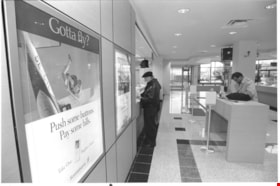
- Photograph of the customer service area at the Kingsway and Wilson Scotiabank location.
- Repository
- City of Burnaby Archives
- Date
- December 11, 1996
- Collection/Fonds
- Burnaby NewsLeader photograph collection
- Physical Description
- 1 photograph : b&w ; 16.5 x 24.5 cm
- Description Level
- Item
- Record No.
- 535-0509
- Access Restriction
- No restrictions
- Reproduction Restriction
- No reproduction permitted
- Accession Number
- 2012-11
- Scope and Content
- Photograph of the customer service area at the Kingsway and Wilson Scotiabank location.
- Media Type
- Photograph
- Photographer
- Bartel, Mario
- Notes
- Title based on contents of photograph
- Note in black ink on recto of photograph reads: "12/11 Scotia B-7 59% / Bby 2998 Mario E"
- Trim marks and/or reproduction instructions on recto (scan is cropped)
Images

Scotiabank staff
https://search.heritageburnaby.ca/link/archivedescription79763
- Repository
- City of Burnaby Archives
- Date
- December 11, 1996
- Collection/Fonds
- Burnaby NewsLeader photograph collection
- Description Level
- Item
- Physical Description
- 1 photograph : b&w ; 14.5 x 22 cm
- Scope and Content
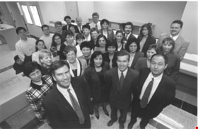
- Photograph of the Scotiabank staff at Kingsway and Wilson in Burnaby.
- Repository
- City of Burnaby Archives
- Date
- December 11, 1996
- Collection/Fonds
- Burnaby NewsLeader photograph collection
- Physical Description
- 1 photograph : b&w ; 14.5 x 22 cm
- Description Level
- Item
- Record No.
- 535-0505
- Access Restriction
- No restrictions
- Reproduction Restriction
- No reproduction permitted
- Accession Number
- 2012-11
- Scope and Content
- Photograph of the Scotiabank staff at Kingsway and Wilson in Burnaby.
- Media Type
- Photograph
- Notes
- Title based on contents of photograph
- Note in black and blue ink on recto of photograph reads: "p. B-2 112% / Bby 2894"
- Trim marks and/or reproduction instructions on recto (scan is cropped)
Images

Site of Martin's Auto Villa at 6604 Hastings Street East
https://search.heritageburnaby.ca/link/museumdescription15045
- Repository
- Burnaby Village Museum
- Date
- 24 Sep. 1945
- Collection/Fonds
- Elmer Wilson Martin fonds
- Description Level
- Item
- Physical Description
- 1 photograph : b&w ; 7 x 11.5 cm
- Scope and Content
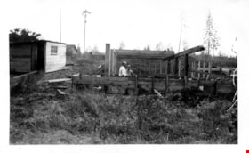
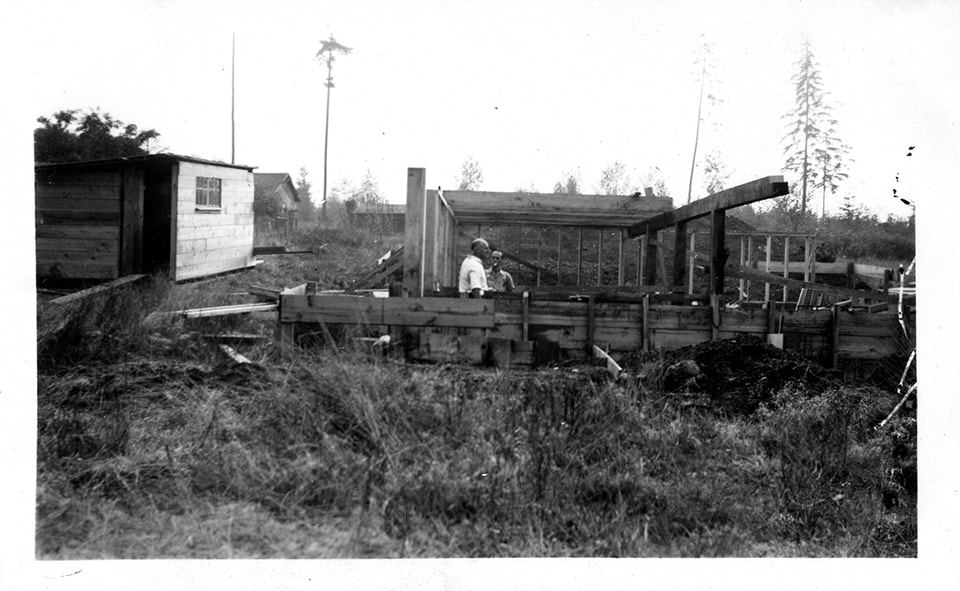
- Photograph of two men standing on the building site for E.W. Martin's Auto Villa. The men are standing in the wooden framework of the building "Martin's Auto Villa" located in District Lot 206, 6604 Hastings Street (after 1950 - 6574 East Hastings Street). The wood framework is surrounded by tall g…
- Repository
- Burnaby Village Museum
- Collection/Fonds
- Elmer Wilson Martin fonds
- Description Level
- Item
- Physical Description
- 1 photograph : b&w ; 7 x 11.5 cm
- Scope and Content
- Photograph of two men standing on the building site for E.W. Martin's Auto Villa. The men are standing in the wooden framework of the building "Martin's Auto Villa" located in District Lot 206, 6604 Hastings Street (after 1950 - 6574 East Hastings Street). The wood framework is surrounded by tall grass and debris.
- Subjects
- Construction
- Names
- Martin's Auto Villa
- Geographic Access
- Hastings Street
- Street Address
- 6574 Hastings Street
- Accession Code
- BV019.37.20
- Access Restriction
- No restrictions
- Reproduction Restriction
- No known restrictions
- Date
- 24 Sep. 1945
- Media Type
- Photograph
- Planning Study Area
- Lochdale Area
- Scan Resolution
- 600
- Scan Date
- February 4, 2021
- Scale
- 100
- Notes
- Title based on contents of photograph
- See also BV019.37.16
- Note in blue ink on verso of photograph reads: Sept. 24th 1945 / Dane Ramage [sic] & Bert / 6604 Hastings St. E."
Images
![Survey and Subdivision plans in New Westminster District Group 1 – Burnaby
, [1908] thumbnail](/media/hpo/_Data/_BVM_Cartographic_Material/1977/1977_0093_0004a_001.jpg?width=280)
Survey and Subdivision plans in New Westminster District Group 1 – Burnaby
https://search.heritageburnaby.ca/link/museumdescription6973
- Repository
- Burnaby Village Museum
- Date
- [1908]
- Collection/Fonds
- Burnaby Village Museum Map collection
- Description Level
- File
- Physical Description
- 10 plans : blueprint ink on paper mounted on 2 sides of cardboard ; 76 cm x 102 cm
- Scope and Content
- Item consists of a large board of four New Westminster District Gp 1 - subdivision plans mounted on one side and six New Westminster District Gp 1 - subdivision plans mounted on the other side. Side A: 1. Blueprint "Plan / of - ReSubdivision / of / Lots 1-18 inclusive / Blocks 20 and 21 / in Sub…
- Repository
- Burnaby Village Museum
- Collection/Fonds
- Burnaby Village Museum Map collection
- Description Level
- File
- Physical Description
- 10 plans : blueprint ink on paper mounted on 2 sides of cardboard ; 76 cm x 102 cm
- Material Details
- Scales [between 1:792 and 1:4752]
- Index number on edge of board reads: "4"
- Scope and Content
- Item consists of a large board of four New Westminster District Gp 1 - subdivision plans mounted on one side and six New Westminster District Gp 1 - subdivision plans mounted on the other side. Side A: 1. Blueprint "Plan / of - ReSubdivision / of / Lots 1-18 inclusive / Blocks 20 and 21 / in Subdivision / of / Lot 53 -Gr.1 / New Westminster District" / "Subdivision Lot Numbers - Shown in Red". Plan is bordered by First Street / Jorgenson's Line / Fourth Avenue and Second Street with Fifith Avenue running through the centre. There is an index in the upper right corner of the plan. Planned is signed by "Peter Byrne" and "William R. Phillips" and dated July 28, 1908. (Geographic location: Burnaby) 2. Blueprint "Plan / of Subdivision / of / Lot 159 / and a Portion of Lot 158 / Group One / New Westminster District". Plan is bordered by Lots 96 and 97; South Wilson Street; North Arm Road and Lot 160 / Power House Road (Lot 155 A). B.C.E.R. Gilley Station is identified in the upper right corner of the plan. (Geographic location: Burnaby) 3. Blueprint plan identified as "Subdvs 10, L 88 and Lot 25, G. 1" Plan identifies Cumberland Street running from top to the bottom and a Ravine running alongside with the Jensen house, stable and barn. (Geographic location: Burnaby) 4. Blueprint Plan of "Lot 153. G. 1 /New Westminster District". Plan identifies the "New Westminster & Vancouver Tramway" and the "New Westminster and Vancouver Road" running through the plan of Lot 53. (Geographic location: Burnaby) Side B: 1. Blueprint plan of "Profile on Proposed North Rd. Diversion". 2. Blueprint plan (no title) showing wood lots north of Burnaby Lake and Brunette River and west of North Road. Various lots are identified as "Heavily Timbered" (Lot 57); "Splendid Fir and Cedar / Heavy Fir etc. / Fine Cedar" (Lots 143, 148); "Rough Light Timber," (Lot 56); "Some Fir and Cedar" (Lot 40). (Geographic location: Burnaby) 3. Blueprint "Plan / of Subdivision / of a Portion / of Lot 87, Gr.1 / New Westminster District". Plan is bordered by Burnaby Lake at the top and Hastings Road / Lot 86 at the bottom and Lot 90 to the east. "Albert J. Hill B.C.LotS." Annotation in ink reads: " J.A. Brownlee, B.C.L.S. / Subdivision / Map 1494 / Bd. 248". Plan is signed by "Peter Byrne, Reeve" (Geographic location: Burnaby) 4. Blueprint plan of Subdivisions along either side of Douglas Road including Lots 117; 119; 74; 80; 79 and 77. (Geographic location: Burnaby) 5. Blueprint "Plan / of / Subdivision of / Lot 27 / in Subdivision / of / Lot 30 / Group One / New Westminster District" Plan is bordered by Lot 26, Lot 28 and Hastings Rd. Lot 27 runs north of Edmonds Street. , "Albert J. Hill, B.C.LotS." (Geographic location: Burnaby) 6. Blueprint plan identified as a "Cultivated Orchard" including the names "W. Grace" and "G. Mead" located north of the North Arm Fraser River and west of "Twentieth Street_ City Boundary". Handwritten annotation in coloured pencil reads: "Portion of Lot 172" (Geographic location: Burnaby)
- Subjects
- Geographic Features - Forests
- Geographic Access
- Cumberland Street
- North Road
- Hastings Street
- Douglas Road
- Accession Code
- HV977.93.4
- Access Restriction
- No restrictions
- Reproduction Restriction
- No known restrictions
- Date
- [1908]
- Media Type
- Cartographic Material
- Historic Neighbourhood
- Burnaby Lake (Historic Neighbourhood)
- Fraser Arm (Historic Neighbourhood)
- Planning Study Area
- Douglas-Gilpin Area
- Burnaby Lake Area
- Scan Resolution
- 300
- Scale
- 72
- Notes
- Title based on contents of file
- Scale is measured in chains. (One chain equals 792 inches)
- The term "Lot" can also refer to a "District Lot”-
Images
![Survey and Subdivision plans in New Westminster District Group 1 – Burnaby
, [1908] thumbnail](/media/hpo/_Data/_BVM_Cartographic_Material/1977/1977_0093_0004a_001.jpg)

![Survey and Subdivision plans in New Westminster District Group 1 – Burnaby, [1905-1917] thumbnail](/media/hpo/_Data/_BVM_Cartographic_Material/1977/1977_0093_0022a_001.jpg?width=280)
Survey and Subdivision plans in New Westminster District Group 1 – Burnaby
https://search.heritageburnaby.ca/link/museumdescription6991
- Repository
- Burnaby Village Museum
- Date
- [1905-1917]
- Collection/Fonds
- Burnaby Village Museum Map collection
- Description Level
- File
- Physical Description
- 12 plans : 6 black ink on paper + 2 black & col. ink on paper + 4 graphite on paper
- Scope and Content
- Item consists of a large board of six New Westminster District subdivision plans mounted on one side and six New Westminster District subdivision plans mounted on the other side. Side A: 1. Plan drawn in graphite with markings in black ink "Surveyed for Mr. W. Wilson / Paterson Stat. B.C.E.R." . …
- Repository
- Burnaby Village Museum
- Collection/Fonds
- Burnaby Village Museum Map collection
- Description Level
- File
- Physical Description
- 12 plans : 6 black ink on paper + 2 black & col. ink on paper + 4 graphite on paper
- Material Details
- Scales [between 1:360 and 1:3168]
- Index number on edge of board reads: "22"
- Scope and Content
- Item consists of a large board of six New Westminster District subdivision plans mounted on one side and six New Westminster District subdivision plans mounted on the other side. Side A: 1. Plan drawn in graphite with markings in black ink "Surveyed for Mr. W. Wilson / Paterson Stat. B.C.E.R." . Plan includes subdivision of lots situated between B.C.E. Railway and Vancouver Road (Kingsway). (Geographic location: Burnaby) 2. Subdivision plan (no title) drawn in black ink with annotations in graphite. Plan covers District Lots 2, 4 and 6, west of North Road. Plan is stamped: "Albert J. Hill, Civil Engineer / and / Provincial Land Surveyor, / New Westminster, / B.C. (Geographic location: Burnaby) 3. Plan of "Portion of Municipality" with intials "RB" [sic] (handwritten in blue crayon). Plan covers the area north east of the City of New Westminster including District Lots 11, 13, 14, 12, 1 and 2. Plan is stamped: "Albert J. Hill, Civil Engineer / and / Provincial Land Surveyor, / New Westminster, / B.C. (Geographic location: Burnaby) 4."Plan / of Subdivision of / N.W.1/4 Lot 175 / Group 1 New West. Dist. / B.C. / Scale 4 chs = 1 in. " Plan is stamped: "Albert J. Hill, Civil Engineer / and / Provincial Land Surveyor, / New Westminster, / B.C. and initialed : "RB" [sic] (in blue pencil crayon) (Geographic location: Burnaby) 5. "Subdivision / of a Portion of / Lot 15 Group 1 / New Westminster Dist. / Scale 4 chs = 1 in". Plan provides numbered sudivisions - Lots 1 to 15 of District Lot 15 in red ink. (Geographic location: Burnaby) 6. Plan of "Central Park & / Vicinity" Plan includes subdivisions of District Lot 153 east of Central Park District Lot 151 and subdivision of District Lot 36 and 49 west of Boundary Road (Vancouver). Plan is stamped: "Albert J. Hill, Civil Engineer / and / Provincial Land Surveyor, / New Westminster, / B.C. and initialed : "RB" [sic] (in blue pencil crayon). (Geographic location: Burnaby) Side B: 1. Subdivision plan (no title) drawn in black ink. Plan identifies lots between Vancouver Road (Yale Road is crossed out and replaced with Vancouver Road) and B.C.E. Railway. "Scale 2 chs = 1 in" (Geographic location: Burnaby) 2. Plan of "Subdivision Lot 1 / Lot 69 Gr. 1 / Scale 30' = 1 " " Plan identifies Boundary Road, Still Creek and a Road Allowance between District Lot 118 and District Lot 69. Plan was "Surveyed for Burnaby Mun. Council / March 11th 1908 / G.K.B." (Geographic location: Burnaby) 3. Plan drawn in black ink (no title) showing a subdivision in Lot 25 with names "Newcomb", "Debeck" and "Armstrong" along with roads identified as Third Street, Cumberland Street, Armstrong Street and Cariboo [sic] Street and including Lots 27, 11 and 13.Plan is stamped: "Albert J. Hill, Civil Engineer / and / Provincial Land Surveyor, / New Westminster, / B.C. and initialed : "RB" [sic] (in blue pencil crayon). (Geographic location: Burnaby) 4. Handrawn subdivision plan in graphite titled: "Lot 13, Gr.1" with intials "RB" [sic] (handwritten in blue crayon). Plan is bordered by Armstrong Street (Lot 11, G.1), Cumberland St. (Lot 25, G.1) and Tenth Avenue (City Boundary). The plan is singed by "Albert J. Hill / P.L.S." and one of the subdivided lots is identified with the name: "W. Karrymann". (Geographic location: Burnaby) 5. Handrawn sketch in graphite titled: "Lot 88, Gr.1" with intials "RB" [sic] (handwritten in blue crayon). Plan appears to be a draft of a subdivision plan of a portion of District Lot 88 along Cumberland Road. The plan is signed: "16/7/17 _W.F. Draper [sic] / B.C.L.S." (Geographic location: Burnaby) 6. "Plan / of Subdivision / of Blocks 61, 62 and 2 / Lot 30 / Group 1 / N.W. Dist. / Scale 1ch = 1 in". Plan is intialed by: "PB" with a note: "Also see board 2 / for duplicate" (handwritten in blue crayon). (Geographic location: Burnaby)
- Creator
- Hill, Albert James
- Geographic Access
- Boundary Road
- Kingsway
- Cumberland Street
- Accession Code
- HV977.93.22
- Access Restriction
- No restrictions
- Reproduction Restriction
- No known restrictions
- Date
- [1905-1917]
- Media Type
- Cartographic Material
- Historic Neighbourhood
- Central Park (Historic Neighbourhood)
- Scan Resolution
- 300
- Scale
- 100
- Notes
- Title based on contents of file
- Scale is measured in chains and feet. (One chain equals 792 inches)
- The term "Lot" can also refer to a "District Lot”
- Some plans are stamped: "Albert J. Hill, Civil Engineer / and / Provincial Land Surveyor, / New Westminster, / B.C." and intialed: "RB" [sic]
Images
![Survey and Subdivision plans in New Westminster District Group 1 – Burnaby, [1905-1917] thumbnail](/media/hpo/_Data/_BVM_Cartographic_Material/1977/1977_0093_0022a_001.jpg)

trophy
https://search.heritageburnaby.ca/link/museumartifact46517
- Repository
- Burnaby Village Museum
- Accession Code
- BV004.7.2
- Description
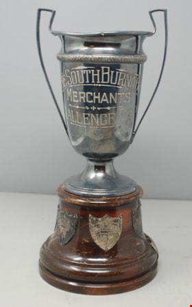
- Trophy, silver; "The South Burnaby Merchants Challenge Cup"; nine silver shields around brown wood base, "T.L. Heads" "1937", "T.L. Heads" "1938", "A. Shannon" "1939", "E.A.S. Carpenter" "1940", "Mrs. W.T. Wilson" "1941", "Mrs. J.A. Siggers" "1942", "W.S. Shannon" "1949", "Mrs. W.T. Willson" "1950" "W. Shannon" "1951"; tarnish, crazing of varnish on base; "1788" on underside, also "Wm. A. Rogers" decal; "Silver Plated ---"
- Object History
- The South Burnaby Merchants Challenge Cup was awarded to the person who won the most points at Horticultural fair. (Vancouver Sun - 16 Nov 1940). 1937 and 1938 winner "T.L. Heads" was likely Burnaby resident Thomas Laing Heads (1891-1944). At the time of his death, Thomas was residing at 2754 Sussex Avenue. He was elected president of the South Burnaby Horticultural Association & Farmers' Institute in 1940. Nothing further is known about 1939 winner "A. Shannon" as of August 2019. 1940 winner "E.A.S. Carpenter" was Ernest Albert S. Carpenter (1960). At the time of his death, Ernest was residing at 2531 Neville Street, Burnaby (later re-numbered 6407 Neville Street).He was elected a director of the South Burnaby Horticultural Association & Farmers' Institute in 1940. 1941 and 1950 winner "Mrs. W.T. Willson" was Clare (Jenkins) Willson. She was married to William Tate Willson (1883-1967), Reeve of Burnaby from 1943 to 1944. The couple were frequent entrants and winners in flower shows around the Lower Mainland. Clare was elected a director of the South Burnaby Horticultural Association & Farmers' Institute in 1940. 1942 winner "Mrs. J.A. Siggers" was Nancy Evelyn (Duckett) (Smith) Siggers (1912-2006). She was married to John Arthur Siggers (1905-1968) in Burnaby in 1938. The couple resided at 6890 Gray Avenue, Burnaby (formerly 2343 Gray Avenue). John's death certificate lists his occupation as "Gardner - Nursery Man". Nancy also worked in the gardening business and the couple were frequent entrants and winners in flower shows around the Lower Mainland. 1949 and 1951 winner "W.S. Shannon" was John Wesley "Wes" Shannon. In 1951, Wes was living at 2325 Waverley Avenue, Burnaby. He was elected a director of the South Burnaby Horticultural Association & Farmers' Institute in 1940 and was president in 1942. He was also chairman of the PNE horitcultural show for 13 years. He worked as a buyer for Kelly Douglas for 47 years before retiring in 1971.
Images

trophy beer stein
https://search.heritageburnaby.ca/link/museumartifact85777
- Repository
- Burnaby Village Museum
- Accession Code
- BV015.31.9
- Description
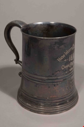
- Silver plated, pewter beer stein with a glass bottom. The stein is a presentation trophy from the Royal Agricultural and Industrial Exhibition held at New Westminster. NEW - WESTR CELEBRATION 1893 CANOE RACE FOURS WON BY H.T. TOVEY E. H. JOHNSTON F. R. WILSON G. L. BROWN Engraved on the face opposite the handle. Amateur race with single blades, straight line for 1/3 of a mile. No makers marks
- Object History
- The original owner of the object was Hamilton Tennent Tovey, grandfather of the donor's husband. The trophy was presented at the 1893 annual exhibition of the Royal Agricultural and Industrial Society of British Columbia at New Westminster, Sept. 26th to 29th, 1893. The amateur canoe races were held Thursday Sept 28th.
- Reference
- https://ia800208.us.archive.org/30/items/cihm_16048/cihm_16048.pdf This was printed off for reference library.
- Measurements
- Overall measurements: base diameter 10.5 cm by height 12 cm. mouth diameter 8.3 cm , length handle to front face 14 cm.
Images

![Two bulldozers, [194-] thumbnail](/media/hpo/_Data/_BVM_Images/1971/197100120076.jpg?width=280)
Two bulldozers
https://search.heritageburnaby.ca/link/museumdescription8
- Repository
- Burnaby Village Museum
- Date
- [194-]
- Collection/Fonds
- Burnaby Village Museum Photograph collection
- Description Level
- Item
- Physical Description
- 1 photograph : b&w ; 6.8 x 11.4 cm
- Scope and Content
- Photograph of two bulldozers, belonging to "Holmes & Wilson Trucking", clearing a lot beside a row of houses. Building materials (bricks and lumber) are piled nearby. This may be related to the construction of the Willingdon Heights subdivision. Stamp on back of photograph reads: "342x."
- Repository
- Burnaby Village Museum
- Collection/Fonds
- Burnaby Village Museum Photograph collection
- Description Level
- Item
- Physical Description
- 1 photograph : b&w ; 6.8 x 11.4 cm
- Scope and Content
- Photograph of two bulldozers, belonging to "Holmes & Wilson Trucking", clearing a lot beside a row of houses. Building materials (bricks and lumber) are piled nearby. This may be related to the construction of the Willingdon Heights subdivision. Stamp on back of photograph reads: "342x."
- Subjects
- Industries - Construction
- Buildings - Residential - Houses
- Construction Tools and Equipment
- Names
- Bingham, Alfred "Alf"
- Accession Code
- HV971.12.76
- Access Restriction
- No restrictions
- Reproduction Restriction
- No known restrictions
- Date
- [194-]
- Media Type
- Photograph
- Historic Neighbourhood
- Vancouver Heights (Historic Neighbourhood)
- Planning Study Area
- Willingdon Heights Area
- Scan Resolution
- 600
- Scan Date
- 2023-03-21
- Notes
- Title based on contents of photograph
Images
![Two bulldozers, [194-] thumbnail](/media/hpo/_Data/_BVM_Images/1971/197100120076.jpg)
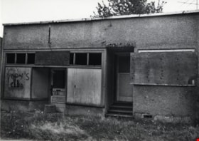
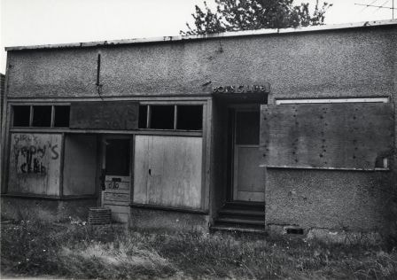
Vacant Building
https://search.heritageburnaby.ca/link/archivedescription79738
- Repository
- City of Burnaby Archives
- Date
- September 22, 1976
- Collection/Fonds
- Burnaby Public Library Contemporary Visual Archive Project
- Description Level
- Item
- Physical Description
- 1 photograph : b&w ; 11 x 16 cm mounted on cardboard
- Scope and Content
- Photograph shows a vacant building onced used as a boys club, located on Patterson Avenue between Beresford Street and Wilson Avenue.
- Repository
- City of Burnaby Archives
- Date
- September 22, 1976
- Collection/Fonds
- Burnaby Public Library Contemporary Visual Archive Project
- Physical Description
- 1 photograph : b&w ; 11 x 16 cm mounted on cardboard
- Description Level
- Item
- Record No.
- 556-410
- Access Restriction
- No restrictions
- Reproduction Restriction
- Reproduce for fair dealing purposes only
- Accession Number
- 2013-13
- Scope and Content
- Photograph shows a vacant building onced used as a boys club, located on Patterson Avenue between Beresford Street and Wilson Avenue.
- Media Type
- Photograph
- Photographer
- McCarron, John
- Notes
- Scope note taken directly from BPL photograph description.
- 1 b&w copy negative : 10 x 12.5 cm accompanying
- Geographic Access
- Patterson Avenue
Images
Vera Armstrong scrapbook
https://search.heritageburnaby.ca/link/museumdescription4586
- Repository
- Burnaby Village Museum
- Date
- 1960-1970 (date of original), copied 2016
- Collection/Fonds
- Burnaby Girl Guides fonds
- Description Level
- File
- Physical Description
- 1 scrapbook (2 digital files : (pdf) + 58 photographs : col. (tiffs) + 58 photographs)
- Scope and Content
- File consists of images of a scrapbook that was created by Vera Armstrong during her involvement with the Burnaby Girl Guides. The scrapbook is composed mostly of photographs along with a few newspaper clippings, correspondence and ephemera about Guiding and camps. Both originals and copies of than…
- Repository
- Burnaby Village Museum
- Collection/Fonds
- Burnaby Girl Guides fonds
- Description Level
- File
- Physical Description
- 1 scrapbook (2 digital files : (pdf) + 58 photographs : col. (tiffs) + 58 photographs)
- Scope and Content
- File consists of images of a scrapbook that was created by Vera Armstrong during her involvement with the Burnaby Girl Guides. The scrapbook is composed mostly of photographs along with a few newspaper clippings, correspondence and ephemera about Guiding and camps. Both originals and copies of thank you letters from various organizations regarding donations are included. Much of the photograph collection is described as outings and events such as; hiking on Burnaby Mountain, visiting a sheep farm in Ladner, Stanley Park, Wilson Creek and camps with various themes, a Powell Church service, a Winter Camp and a visit to the Parthenon in West Vancouver (built by resident Nick Kogo in the 1960s and demolished or moved sometime in the 1990s).
- Creator
- Armstrong, Vera
- Accession Code
- BV015.35.158
- Access Restriction
- No restrictions
- Reproduction Restriction
- May be restricted by third party rights
- Date
- 1960-1970 (date of original), copied 2016
- Media Type
- Photograph
- Textual Record
- Notes
- Title based on contents of file
- Digital images were created of the scrapbook prior to selective retention of original records that were removed for conservation purposes
- Three photographs from scrapbook have been retained and described at item level (BV015.35.189, BV015.35.190 and BV015.35.255)
- Other photographs have been retained under file BV015.35.158 (no item level descriptions)
Images

Documents
Victor Kirincich
https://search.heritageburnaby.ca/link/archivedescription79776
- Repository
- City of Burnaby Archives
- Date
- December 11, 1996
- Collection/Fonds
- Burnaby NewsLeader photograph collection
- Description Level
- Item
- Physical Description
- 1 photograph : b&w ; 16.5 x 11 cm
- Scope and Content
- Photograph of Victor Kirincich, customer service representative at the Kingsway and Wilson Scotiabank location.
- Repository
- City of Burnaby Archives
- Date
- December 11, 1996
- Collection/Fonds
- Burnaby NewsLeader photograph collection
- Physical Description
- 1 photograph : b&w ; 16.5 x 11 cm
- Description Level
- Item
- Record No.
- 535-0516
- Access Restriction
- No restrictions
- Reproduction Restriction
- No reproduction permitted
- Accession Number
- 2012-11
- Scope and Content
- Photograph of Victor Kirincich, customer service representative at the Kingsway and Wilson Scotiabank location.
- Names
- Kirincich, Victor
- Media Type
- Photograph
- Notes
- Title based on contents of photograph
- Note in black ink on recto of photograph reads: "Victor 22% Scotia / 5 Bby 2927 B - 3"
- Trim marks and/or reproduction instructions on recto (scan is cropped)
Images

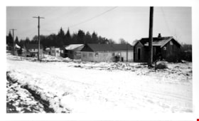
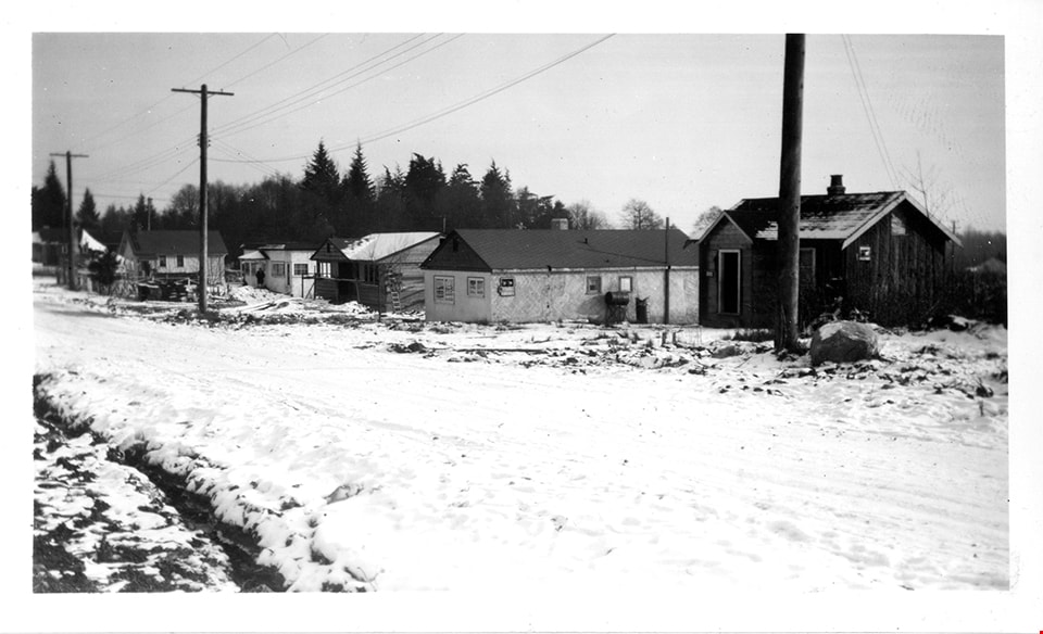
Winch Street program
https://search.heritageburnaby.ca/link/museumdescription15051
- Repository
- Burnaby Village Museum
- Date
- Jan. 1949
- Collection/Fonds
- Elmer Wilson Martin fonds
- Description Level
- Item
- Physical Description
- 1 photograph : b&w ; 7 x 11.5 cm
- Scope and Content
- Photograph of a row of houses on Winch Street in Burnaby. The ground is covered with snow.
- Repository
- Burnaby Village Museum
- Collection/Fonds
- Elmer Wilson Martin fonds
- Description Level
- Item
- Physical Description
- 1 photograph : b&w ; 7 x 11.5 cm
- Scope and Content
- Photograph of a row of houses on Winch Street in Burnaby. The ground is covered with snow.
- Geographic Access
- Winch Street
- Street Address
- 6656 Winch Street
- Accession Code
- BV019.37.26
- Access Restriction
- No restrictions
- Reproduction Restriction
- No known restrictions
- Date
- Jan. 1949
- Media Type
- Photograph
- Scan Resolution
- 600
- Scan Date
- February 4, 2021
- Scale
- 100
- Notes
- Title based on contents of photograph
- Note in blue ink on verso of photograph reads: "Winch St. Program / Jan. 1949"
- Stamp in black ink on verso of photograph reads: "611"
Images
![Work Party, [1958] thumbnail](/media/hpo/_Data/_BVM_Images/2015/2015_0035_0255_001.jpg?width=280)
Work Party
https://search.heritageburnaby.ca/link/museumdescription4897
- Repository
- Burnaby Village Museum
- Date
- [1958]
- Collection/Fonds
- Burnaby Girl Guides fonds
- Description Level
- Item
- Physical Description
- 1 photograph : b&w ;11.5 x 8.5 cm
- Scope and Content
- Photograph of a group of people seated on the stairs of a porch near Wilson Creek. People are identified in the front row L to R: Mr. Don, Jamieson, Mr. Morgan Jenkins, (one of the Harrower children), Mrs. J.W. Roper, Mr. Wm. Harrower and in the back row L to R: Mr. J. G. Fowler, Mr. Neil McLean, M…
- Repository
- Burnaby Village Museum
- Collection/Fonds
- Burnaby Girl Guides fonds
- Description Level
- Item
- Physical Description
- 1 photograph : b&w ;11.5 x 8.5 cm
- Material Details
- Handwritten text in pencil on back of photograph reads: "Guides".
- Scope and Content
- Photograph of a group of people seated on the stairs of a porch near Wilson Creek. People are identified in the front row L to R: Mr. Don, Jamieson, Mr. Morgan Jenkins, (one of the Harrower children), Mrs. J.W. Roper, Mr. Wm. Harrower and in the back row L to R: Mr. J. G. Fowler, Mr. Neil McLean, Miss Ethel Steele, Mrs. Wm. Harrower, Mr. Dick Hardy and Mrs. J.G. Fowler.
- Names
- Girl Guides of Canada
- Jenkins, Morgan
- Jamieson, Donald H.
- Roper, Isabelle
- Harrower, William
- Fowler, J.G.
- McLean, Neil
- Steele, Ethel
- Hardy, Dick
- Fowler, Mrs. J.G.
- Harrower, Mrs. William
- Accession Code
- BV015.35.255
- Access Restriction
- No restrictions
- Reproduction Restriction
- May be restricted by third party rights
- Date
- [1958]
- Media Type
- Photograph
- Scan Resolution
- 600
- Scale
- 100
- Notes
- Title based on caption of photograph
- Note in black ink on scrapbook page reads: "Work Party (1958) / Front Row L to R : Mr. Don Jamison; Mr. Morgan Jenkins, (one of the Harrower children), Mrs. J. W. Roper, Mr. Wm. Harrower. / Back Row : Mr. J.G. Fowler, Mr. Neil Mclean, Miss Ethel Steele, Mrs. Wm. / Harrower, Mr. Dick Hardy & Mrs. J.G. Fowler"
- Photograph is a part of scrapbook "Burnaby Girl Guides. -- [1914]-1969, predominant ca. 1920" (BV.015.35.164)
Images
![Work Party, [1958] thumbnail](/media/hpo/_Data/_BVM_Images/2015/2015_0035_0255_001.jpg)