Narrow Results By
Decade
- 2020s 61
- 2010s 67
- 2000s 80
- 1990s 197
- 1980s 170
- 1970s 182
- 1960s 150
- 1950s 199
- 1940s 218
- 1930s 259
- 1920s 211
- 1910s
- 1900s 133
- 1890s 46
- 1880s 15
- 1870s 6
- 1860s 4
- 1850s 2
- 1840s 1
- 1830s
- 1820s 1
- 1810s 1
- 1800s 1
- 1790s 1
- 1780s 1
- 1770s 1
- 1760s 1
- 1750s 1
- 1740s 1
- 1730s 1
- 1720s 1
- 1710s 1
- 1700s 1
- 1690s 1
- 1680s 1
- 1670s 1
- 1660s 1
- 1650s 1
- 1640s 1
- 1630s 1
- 1620s 1
- 1610s 1
- 1600s 1
Subject
- Accidents - Train Accidents 1
- Advertising Medium - Signs and Signboards 1
- Agriculture - Farms 2
- Animals - Dogs 1
- Animals - Fowl 1
- Buildings - Commercial 3
- Buildings - Commercial - Grocery Stores 2
- Buildings - Commercial - Train Stations 2
- Buildings - Industrial 1
- Buildings - Industrial - Factories 1
- Buildings - Industrial - Saw Mills 2
- Buildings - Public - Post Offices 3
Creator
- Alymer, Jane 1
- Anderson, H. Graeme (Henry Graeme), 1882-1925 1
- Arnold, Matthew, 1822-1888 1
- Barclay, Florence L. (Florence Louisa), 1862-1921 1
- Barrowclough, George Alfred 3
- Bateman, Caroline Mary Wettenhall 1
- B.C. Leather and Findings Company 2
- Blackstone, W. E. (William E.), 1841-1935 1
- Brady, Mary J. 1
- British Columbia Fruit Growers' Association 1
- Broadbridge Commercial Photo Company 1
- Buckland, A. R. (Augustus Robert), 1857-1942 1
Person / Organization
- All Saints Anglican Church 1
- Babey, Beverley 1
- Bateman, Edwin W. 1
- Black, George 1
- Brandrith, Martha Dorothy “Dot” Love 1
- British Columbia Mills Timber and Trading Company 2
- Burnaby Central Secondary School 1
- Burnaby City Hall 1
- Byrne, Peter 1
- Canada Way Food Market 1
- Canadian Pacific Railway Company 5
- Chow, Josephine 1

Indexed guide map of the city of Vancouver and Suburbs
https://search.heritageburnaby.ca/link/museumdescription8694
- Repository
- Burnaby Village Museum
- Date
- 1914
- Collection/Fonds
- Burnaby Village Museum Map collection
- Description Level
- Item
- Physical Description
- 1 map + textual record : col. lithographic print on paper ; 55 x 78 cm on sheet 58.5 x 82 cm folded to 20 x 10 cm
- Scope and Content
- Item consists of a map "Indexed Guide Map of the City of Vancouver and Suburbs compiled and published by The Vancouver Map and Blueprint Co. Ltd. Map shows district lots, blocks and boundaries between City of Vancouver, Point Grey, South Vancouver, Burnaby, New Westminster and parts of Richmond, No…
- Repository
- Burnaby Village Museum
- Collection/Fonds
- Burnaby Village Museum Map collection
- Description Level
- Item
- Physical Description
- 1 map + textual record : col. lithographic print on paper ; 55 x 78 cm on sheet 58.5 x 82 cm folded to 20 x 10 cm
- Material Details
- Scale not defined
- Map is folded into booklet form
- Scope and Content
- Item consists of a map "Indexed Guide Map of the City of Vancouver and Suburbs compiled and published by The Vancouver Map and Blueprint Co. Ltd. Map shows district lots, blocks and boundaries between City of Vancouver, Point Grey, South Vancouver, Burnaby, New Westminster and parts of Richmond, North Vancouver and West Vancouver. Concentric cirlces indicate the distance in miles from the intersection of Main Street and Hastings Street, Vancouver in intervals of 1/2 mile. Map is folded into booklet form and includes a four page index with cardstock cover. Index page 1 is titled "Hotels"; page 2 is titled "District Lot Index"; pages 3-8 "Street Index".
- Publisher
- Vancouver Map and Blueprint Company Limited
- Edition
- 5th Edition revised to June 1914
- Geographic Access
- Vancouver
- Accession Code
- HV983.9.18
- Date
- 1914
- Media Type
- Cartographic Material
- Scan Resolution
- 600
- Scan Date
- 2023-08-17
- Notes
- Transcribed title from map and cover
- Sticker adhered to front cover of index of two lions "Service / "WE GIVE IT" / WESTERN SPECIALTY / LIMITED/ STATIONERS AND PRINTERS / VANCOUVER - B.C."
Documents
Zoomable Images

![Bandsand in Stanley Park, Vancouver, BC, [between 1908 and 1911] thumbnail](/media/hpo/_Data/_BVM_Images/1972/1972_0050_0010_001.jpg?width=280)
Bandsand in Stanley Park, Vancouver, BC
https://search.heritageburnaby.ca/link/museumdescription1071
- Repository
- Burnaby Village Museum
- Date
- [between 1908 and 1911]
- Collection/Fonds
- Burnaby Village Museum Photograph collection
- Description Level
- Item
- Physical Description
- 1 photograph : sepia ; 7.3 x 9.9 cm
- Scope and Content
- Photograph of people walking towards the bandstand in Stanley Park, Vancouver. In 1934, the Malkin Bowl was erected at the site where the banstand used to be. An annotation on the back of the photograph reads, "Band stand in Stanley Park where Malkin Bowl now stands."
- Repository
- Burnaby Village Museum
- Collection/Fonds
- Burnaby Village Museum Photograph collection
- Description Level
- Item
- Physical Description
- 1 photograph : sepia ; 7.3 x 9.9 cm
- Scope and Content
- Photograph of people walking towards the bandstand in Stanley Park, Vancouver. In 1934, the Malkin Bowl was erected at the site where the banstand used to be. An annotation on the back of the photograph reads, "Band stand in Stanley Park where Malkin Bowl now stands."
- Geographic Access
- Vancouver
- Accession Code
- HV972.50.10
- Access Restriction
- No restrictions
- Reproduction Restriction
- No known restrictions
- Date
- [between 1908 and 1911]
- Media Type
- Photograph
- Scan Resolution
- 600
- Scan Date
- 2023-04-04
- Photographer
- Dean, H.M.
- Notes
- Title based on contents of photograph
Images
![Bandsand in Stanley Park, Vancouver, BC, [between 1908 and 1911] thumbnail](/media/hpo/_Data/_BVM_Images/1972/1972_0050_0010_001.jpg)
![Bird's eye view of New Westminster, Burnaby and Vancouver, [ca. 1911] thumbnail](/media/hpo/_Data/_BVM_Cartographic_Material/1983/1983_0012_0001_002%20Web.jpg?width=280)
Bird's eye view of New Westminster, Burnaby and Vancouver
https://search.heritageburnaby.ca/link/museumdescription8199
- Repository
- Burnaby Village Museum
- Date
- [ca. 1911]
- Collection/Fonds
- Burnaby Village Museum Map collection
- Description Level
- Item
- Physical Description
- 1 map : hand painted ; 65.5 x 99 cm
- Scope and Content
- An untitled monochromatic grayscale map of a developer's bird's eye view looking north west from Burnaby Mountain. View includes Burnaby, New Westminster, Vancouver with the North shore in the distance. Burnaby neighbourhood subdivisions of "Burnaby Heights" and "Buena Vista" are featured near the…
- Repository
- Burnaby Village Museum
- Collection/Fonds
- Burnaby Village Museum Map collection
- Description Level
- Item
- Physical Description
- 1 map : hand painted ; 65.5 x 99 cm
- Scope and Content
- An untitled monochromatic grayscale map of a developer's bird's eye view looking north west from Burnaby Mountain. View includes Burnaby, New Westminster, Vancouver with the North shore in the distance. Burnaby neighbourhood subdivisions of "Burnaby Heights" and "Buena Vista" are featured near the centre of the map. These neighbourhood subdivisions were marketed by Real Estate Agents Liebly & Blumer in 1911. Roads, buildings, factories, railways and bridges are identified on the map.
- Subjects
- Businesses - Real Estate Agencies
- Responsibility
- Leibly & Blumer Realty Co. Incorporated
- Accession Code
- HV983.12.1
- Access Restriction
- No restrictions
- Reproduction Restriction
- No known restrictions
- Date
- [ca. 1911]
- Media Type
- Cartographic Material
- Historic Neighbourhood
- East Burnaby (Historic Neighbourhood)
- Vancouver Heights (Historic Neighbourhood)
- Planning Study Area
- Cariboo-Armstrong Area
- Burnaby Heights Area
- Scan Resolution
- 300
- Scan Date
- December 2020
- Scale
- 100
- Notes
- Title based on contents of map
- Note in pencil on verso of photograph reads: "Make tint block of Buena Vista / Blocks only as shown in lots"
Zoomable Images
![Bird's eye view of New Westminster, Burnaby and Vancouver, [ca. 1911] thumbnail](/media/hpo/_Data/_BVM_Cartographic_Material/1983/1983_0012_0001_001_seadragon/1983_0012_0001_001.jpg?w=280)
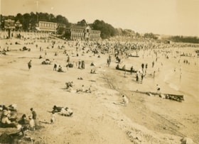
English Bay, Vancouver
https://search.heritageburnaby.ca/link/museumdescription1072
- Repository
- Burnaby Village Museum
- Date
- 1911
- Collection/Fonds
- Burnaby Village Museum Photograph collection
- Description Level
- Item
- Physical Description
- 1 photograph : b&w ; 7.3 x 9.9 cm
- Scope and Content
- Photograph of the beach at English Bay, Vancouver. The beach is crowded an buildings can be seen in the background.
- Repository
- Burnaby Village Museum
- Collection/Fonds
- Burnaby Village Museum Photograph collection
- Description Level
- Item
- Physical Description
- 1 photograph : b&w ; 7.3 x 9.9 cm
- Scope and Content
- Photograph of the beach at English Bay, Vancouver. The beach is crowded an buildings can be seen in the background.
- Geographic Access
- Vancouver
- Accession Code
- HV972.50.11
- Access Restriction
- No restrictions
- Reproduction Restriction
- No known restrictions
- Date
- 1911
- Media Type
- Photograph
- Scan Resolution
- 600
- Scan Date
- 2023-04-04
- Photographer
- Dean, H.M.
- Notes
- Title based on contents of photograph
- Annotation on verso of photograph reads: "English Bay/ 1911."
Images

General Relief Board - I.O.O.F. of Vancouver
https://search.heritageburnaby.ca/link/museumdescription9762
- Repository
- Burnaby Village Museum
- Date
- [ca. 1915]
- Collection/Fonds
- Hugh H. Stewart fonds
- Description Level
- Item
- Physical Description
- 1 textual record
- Scope and Content
- Item consists of a member card to certify Mr. H.H. Stewart as an accredited member of the General Relief Board, I.O.O.F. of Vancouver, B.C. The card is a visiting permit that allows the bearer to visit the Public or Semi-private Wards of the Vancouver General Hospital at any time. The card is signe…
- Repository
- Burnaby Village Museum
- Collection/Fonds
- Hugh H. Stewart fonds
- Description Level
- Item
- Physical Description
- 1 textual record
- Scope and Content
- Item consists of a member card to certify Mr. H.H. Stewart as an accredited member of the General Relief Board, I.O.O.F. of Vancouver, B.C. The card is a visiting permit that allows the bearer to visit the Public or Semi-private Wards of the Vancouver General Hospital at any time. The card is signed by the V.G.H. superintendent, Malcolm T. MacEachren.
- Names
- Stewart, Hugh Henry
- Accession Code
- HV979.50.271
- Access Restriction
- No restrictions
- Reproduction Restriction
- No known restrictions
- Date
- [ca. 1915]
- Media Type
- Textual Record
- Notes
- Title based on content of Item
![Granville Street, Vancouver, [1911] thumbnail](/media/hpo/_Data/_BVM_Images/1972/1972_0050_0006_001.jpg?width=280)
Granville Street, Vancouver
https://search.heritageburnaby.ca/link/museumdescription1067
- Repository
- Burnaby Village Museum
- Date
- [1911]
- Collection/Fonds
- Burnaby Village Museum Photograph collection
- Description Level
- Item
- Physical Description
- 1 photograph : b&w ; 8.0 x 10.2 cm
- Scope and Content
- Photograph of Granville Street, looking south. The two tall buildings to the sides are under construction. Busy street activities can be seen below with two trams running along the tracks. The old Vancouver Hotel is in view and the old courthouse (later the Vancouver Art Gallery) is in view faint…
- Repository
- Burnaby Village Museum
- Collection/Fonds
- Burnaby Village Museum Photograph collection
- Description Level
- Item
- Physical Description
- 1 photograph : b&w ; 8.0 x 10.2 cm
- Scope and Content
- Photograph of Granville Street, looking south. The two tall buildings to the sides are under construction. Busy street activities can be seen below with two trams running along the tracks. The old Vancouver Hotel is in view and the old courthouse (later the Vancouver Art Gallery) is in view faintly to the right of the photograph. An annoation on the back of the photograph reads, ""Granville St. - with OLD [underlined] / Vancouver Hotel across / from the Birks Building/ 1911/ (Court House in back of Van Hotel)."
- Geographic Access
- Vancouver
- Accession Code
- HV972.50.6
- Access Restriction
- No restrictions
- Reproduction Restriction
- No known restrictions
- Date
- [1911]
- Media Type
- Photograph
- Scan Resolution
- 600
- Scan Date
- 2023-04-04
- Photographer
- Dean, H.M.
- Notes
- Title based on contents of photograph
Images
![Granville Street, Vancouver, [1911] thumbnail](/media/hpo/_Data/_BVM_Images/1972/1972_0050_0006_001.jpg)
![Granville Street, Vancouver, [1910] thumbnail](/media/hpo/_Data/_BVM_Images/1972/1972_0050_0008_001.jpg?width=280)
Granville Street, Vancouver
https://search.heritageburnaby.ca/link/museumdescription1069
- Repository
- Burnaby Village Museum
- Date
- [1910]
- Collection/Fonds
- Burnaby Village Museum Photograph collection
- Description Level
- Item
- Physical Description
- 1 photograph : b&w ; 7.4 x 9.8 cm
- Scope and Content
- Photograph of Granville Street, looking north. Signs for "Fletchers Pianos" and the "Colonial Theatre" can be seen. The north shore is faintly visible across Burrard Inlet.
- Repository
- Burnaby Village Museum
- Collection/Fonds
- Burnaby Village Museum Photograph collection
- Description Level
- Item
- Physical Description
- 1 photograph : b&w ; 7.4 x 9.8 cm
- Scope and Content
- Photograph of Granville Street, looking north. Signs for "Fletchers Pianos" and the "Colonial Theatre" can be seen. The north shore is faintly visible across Burrard Inlet.
- Subjects
- Advertising Medium - Signs and Signboards
- Buildings - Commercial
- Geographic Features - Roads
- Geographic Access
- Vancouver
- Accession Code
- HV972.50.8
- Access Restriction
- No restrictions
- Reproduction Restriction
- No known restrictions
- Date
- [1910]
- Media Type
- Photograph
- Scan Resolution
- 600
- Scan Date
- 2023-04-04
- Photographer
- Dean, H.M.
- Notes
- Title based on contents of photograph
- An annotation on the back of the photograph reads, "Granville St. - 1910."
Images
![Granville Street, Vancouver, [1910] thumbnail](/media/hpo/_Data/_BVM_Images/1972/1972_0050_0008_001.jpg)
Legends of Vancouver
https://search.heritageburnaby.ca/link/museumlibrary5197
- Repository
- Burnaby Village Museum
- Collection
- Special Collection
- Material Type
- Book
- Accession Code
- BV002.90.3
- Call Number
- 398.2 JOH
- Edition
- 8th ed.
- Place of Publication
- Vancouver
- Publisher
- Saturday Sunset Presses
- Publication Date
- 1913
- Physical Description
- xvii, 138 p. : ill. ; 23 cm.
- Library Subject (LOC)
- Legends--British Columbia--Vancouver Island
- Spirituality--Indigenous--North America
- Geographic Access
- Vancouver
- Notes
- Leather jacket with painted profile, title, and author, includes leather bookmark and souvenir dagger.
- Inside the jacket is a newspaper clipping of a soldier from Vancouver wounded at Vimy Ridge.
- Author's given name and dates : Johnson, E. Pauline (Emily Pauline), (Tekahionwake),1861-1913
![Miss Scott's class at Vancouver Heights Public School, [after 1912] thumbnail](/media/hpo/_Data/_BVM_Images/1985/198900190001.jpg?width=280)
Miss Scott's class at Vancouver Heights Public School
https://search.heritageburnaby.ca/link/museumdescription72
- Repository
- Burnaby Village Museum
- Date
- [after 1912]
- Collection/Fonds
- Burnaby Village Museum Photograph collection
- Description Level
- Item
- Physical Description
- 1 photograph : sepia ; 10 x 15 cm mounted on card 18 x 23 cm
- Scope and Content
- Photograph of Miss Scott's class taken on the steps of Vancouver Heights Public School. The students are standing in seven rows and Miss Scott is standing on the left at the end of the second row.
- Repository
- Burnaby Village Museum
- Collection/Fonds
- Burnaby Village Museum Photograph collection
- Description Level
- Item
- Physical Description
- 1 photograph : sepia ; 10 x 15 cm mounted on card 18 x 23 cm
- Scope and Content
- Photograph of Miss Scott's class taken on the steps of Vancouver Heights Public School. The students are standing in seven rows and Miss Scott is standing on the left at the end of the second row.
- Subjects
- Occupations - Teachers
- Geographic Access
- Gilmore Avenue
- Street Address
- 50 Gilmore Avenue
- Accession Code
- BV989.19.1
- Access Restriction
- No restrictions
- Date
- [after 1912]
- Media Type
- Photograph
- Historic Neighbourhood
- Vancouver Heights (Historic Neighbourhood)
- Planning Study Area
- Burnaby Heights Area
- Scan Resolution
- 600
- Scan Date
- 01-Jun-09
- Scale
- 100
- Photographer
- McConnell, W. F.
- Notes
- Title based on contents of photograph
- Note written in pencil on verso of card mount reads: "R. G. McManus/ 4257 Dundas St [top two lines crossed out]/ North Burnaby B.C" and "c/o Terry Lynn Callender/ TEACHER MISS SCOTT"
- Note written in pen on verso of card mount reads: "AS OF FEB 28/85/ DAVID L. McMANUS/ [address follows]"
- Embossed letters on the card mount reads: "W. F. McConnell/ VANCOUVER, B.C."
Images
![Miss Scott's class at Vancouver Heights Public School, [after 1912] thumbnail](/media/hpo/_Data/_BVM_Images/1985/198900190001.jpg)
Portion of New Westminster District with Adjacent Islands and Part of Vancouver Island
https://search.heritageburnaby.ca/link/museumdescription8690
- Repository
- Burnaby Village Museum
- Date
- 1910
- Collection/Fonds
- Burnaby Village Museum Map collection
- Description Level
- Item
- Physical Description
- 1 map : col. ink on canvas ; 68 x 90 cm on canvas 70 x 95 cm
- Scope and Content
- "Map of Portion of New Westminster District with Adjacent Islands and Part of Vancouver Island / Drawn at the Lands and Works Department. Victoria, B.C."
- Repository
- Burnaby Village Museum
- Collection/Fonds
- Burnaby Village Museum Map collection
- Description Level
- Item
- Physical Description
- 1 map : col. ink on canvas ; 68 x 90 cm on canvas 70 x 95 cm
- Material Details
- Scale 1/4 inch = 80 chains
- Scope and Content
- "Map of Portion of New Westminster District with Adjacent Islands and Part of Vancouver Island / Drawn at the Lands and Works Department. Victoria, B.C."
- Geographic Access
- Vancouver
- Accession Code
- BV994.11.9
- Access Restriction
- No restrictions
- Reproduction Restriction
- No known restrictions
- Date
- 1910
- Media Type
- Cartographic Material
- Notes
- Title based on contents of map
- Cleaned by conservator Dec 2009
![Post Office, Vancouver BC, [between 1908 and 1911] thumbnail](/media/hpo/_Data/_BVM_Images/1972/1972_0050_0004_001.jpg?width=280)
Post Office, Vancouver BC
https://search.heritageburnaby.ca/link/museumdescription1065
- Repository
- Burnaby Village Museum
- Date
- [between 1908 and 1911]
- Collection/Fonds
- Burnaby Village Museum Photograph collection
- Description Level
- Item
- Physical Description
- 1 photograph : sepia ; 8.8 x 10.2 cm, mounted on paper 13.5 x 12.2 cm
- Scope and Content
- Photograph of the post office near the downtown Vancouver waterfront. The north shore can be seen faintly across Burrard Inlet in the background. Inscribed on the negative, printed on the photograph, lower left: "Post Office / Vancouver B.C."
- Repository
- Burnaby Village Museum
- Collection/Fonds
- Burnaby Village Museum Photograph collection
- Description Level
- Item
- Physical Description
- 1 photograph : sepia ; 8.8 x 10.2 cm, mounted on paper 13.5 x 12.2 cm
- Material Details
- inscribed on the negative, printed on the photograph, l.l., "POST OFFICE/ VANCOUVER B.C."
- Scope and Content
- Photograph of the post office near the downtown Vancouver waterfront. The north shore can be seen faintly across Burrard Inlet in the background. Inscribed on the negative, printed on the photograph, lower left: "Post Office / Vancouver B.C."
- Subjects
- Buildings - Public - Post Offices
- Geographic Access
- Vancouver
- Accession Code
- HV972.50.4
- Access Restriction
- No restrictions
- Reproduction Restriction
- No known restrictions
- Date
- [between 1908 and 1911]
- Media Type
- Photograph
- Scan Resolution
- 600
- Scan Date
- 2023-03-28
- Photographer
- Dean, H.M.
Images
![Post Office, Vancouver BC, [between 1908 and 1911] thumbnail](/media/hpo/_Data/_BVM_Images/1972/1972_0050_0004_001.jpg)
![Students at Vancouver Heights Public School, [between 1912 and 1920] thumbnail](/media/hpo/_Data/_BVM_Images/1985/198900190002.jpg?width=280)
Students at Vancouver Heights Public School
https://search.heritageburnaby.ca/link/museumdescription73
- Repository
- Burnaby Village Museum
- Date
- [between 1912 and 1920]
- Collection/Fonds
- Burnaby Village Museum Photograph collection
- Description Level
- Item
- Physical Description
- 1 photograph : sepia ; 15 x 10.5 cm mounted on card 23 x 18 cm
- Scope and Content
- Photograph of students standing in six rows on the steps of Vancouver Heights Public School.
- Repository
- Burnaby Village Museum
- Collection/Fonds
- Burnaby Village Museum Photograph collection
- Description Level
- Item
- Physical Description
- 1 photograph : sepia ; 15 x 10.5 cm mounted on card 23 x 18 cm
- Scope and Content
- Photograph of students standing in six rows on the steps of Vancouver Heights Public School.
- Geographic Access
- Gilmore Avenue
- Street Address
- 50 Gilmore Avenue
- Accession Code
- BV989.19.2
- Access Restriction
- No restrictions
- Date
- [between 1912 and 1920]
- Media Type
- Photograph
- Historic Neighbourhood
- Vancouver Heights (Historic Neighbourhood)
- Planning Study Area
- Burnaby Heights Area
- Scan Resolution
- 600
- Scan Date
- 01-Jun-09
- Scale
- 100
- Notes
- Title based on contents of photograph
- Note written in pencil on verso of card mount reads: "c/o Terry Lynn Callender"
- Note written in pen on verso of card mount reads: "Jessie Horn -/ Mrs. R. G. McManus.", and "AS OF FEB 28/85/ DAVID L. McMANUS/ [address follows]"
Images
![Students at Vancouver Heights Public School, [between 1912 and 1920] thumbnail](/media/hpo/_Data/_BVM_Images/1985/198900190002.jpg)
![Survey and Subdivision plans in New Westminster District Group 1 and Group 2 – Vancouver, ʷməθkʷəy̓əm (Musqueam) Indian Reserve, Burnaby, Surrey
, [1910-1911] thumbnail](/media/hpo/_Data/_BVM_Cartographic_Material/1977/1977_0093_0017_001.jpg?width=280)
Survey and Subdivision plans in New Westminster District Group 1 and Group 2 – Vancouver, ʷməθkʷəy̓əm (Musqueam) Indian Reserve, Burnaby, Surrey
https://search.heritageburnaby.ca/link/museumdescription6986
- Repository
- Burnaby Village Museum
- Date
- [1910-1911]
- Collection/Fonds
- Burnaby Village Museum Map collection
- Description Level
- File
- Physical Description
- 9 plans : 4 plans : blueprint ink on paper + 4 plans : black ink on paper + 1 plan : graphite on paper mounted on 2 sides of cardboard 76 x 102 cm
- Scope and Content
- File consists of a large board of three survey plans in New Westminster District Group 1 mounted on one side and six survey and subdivision plans of District Lot 85, New Westminster District Group 1 mounted on the other side. Side A: 1. Plan : blueprint on paper ; 30.5 x 80 cm. Title reads: "Fras…
- Repository
- Burnaby Village Museum
- Collection/Fonds
- Burnaby Village Museum Map collection
- Description Level
- File
- Physical Description
- 9 plans : 4 plans : blueprint ink on paper + 4 plans : black ink on paper + 1 plan : graphite on paper mounted on 2 sides of cardboard 76 x 102 cm
- Material Details
- Scales vary (One chain equals 792 inches)
- Indexed number on tape on edge of board reads "17"
- Scope and Content
- File consists of a large board of three survey plans in New Westminster District Group 1 mounted on one side and six survey and subdivision plans of District Lot 85, New Westminster District Group 1 mounted on the other side. Side A: 1. Plan : blueprint on paper ; 30.5 x 80 cm. Title reads: "Fraser River Bridge / Plan of South Approach". Plan covers area of land north of the Fraser River and Great Northern Railway with approach for a bridge running through the "ʷməθkʷəy̓əm (Musqueam) Indian Reserve" (ʷməθkʷəy̓əm (Musqueam) First Nation) and lots marked as Dominion Government and the east half of Lot 2 identified as "C. F. Brown" "Plan 851". Plan is identified as "Plan 851 / traced / Mar. 17, 1911". (Geographic location in Vancouver) Scale: 100 feet = 1 inch, Signed by Albert J. Hill / P.L.S." 2. Plan : blueprint on paper ; 36.5 x 35 cm (no title). Includes three plans of lots on the east and west sides of North Road. Note on bottom of blueprint reads: "I.E.B. McKay Surveyor General - hereby certify / that this is a correct tracing from the field / notes of the Royal Engineers on file in the / Lands Department / E.B. McKay (signature) / Surveyor General / Victoria B.C. April 11th 1911" . Plan in top left titled "Page 11 / Vol. 1. / R.E. Notes" covers District Lots east of North Road including Lot 5, Lot 7, Lot 41, Lot 9 and Lot 107 in Coquitlam. Plan in top right corner titled "Page 17 / Vol. 1. / R.E. Notes" covers District Lots east of North Road including Lot 104, Lot 54, Lot 105, Lot 55, Lot 106, Lot 9 and Lot 107 in Coquitlam and Port Moody. Plan in lower left corner titled "Page 15 / Vol. 1 / R.E. Notes" covers District Lots west of North Road including Lot 147, Lot 148, Lot 100, Lot 15 in Burnaby. 3. Plan : blue print on paper ; 29.5 x 41.5 cm. (no formal title). Plan of the North 1/2 of Section 18. Plan covers area in the "North 1/2 of Sec.18 B.5 N RGE 1 W" and "Sec. 18 B.5 N. RGE 1 W" bordered by Section 7, Section 13, Section 17 and Section 19. Bon Accord Road runs through Sec. 18. The plan is signed by surveryor "I.H. Neville Smith... C.E.B.C.L.S. / Mar. 26th 1910" and signed by "Ludwig Pillath". (Geographic location: Surrey) Side B: 1. Plan : blueprint on paper ; 43.5 x 49.5 cm. Title reads: "Plan / of Subdivision / of a Portion / of / Lot 85 / Group One / New Westminster District. Plan covers portion of land east of Deer Lake and Pole Line Road (Sperling Avenue) and south of Hastings Road in District Lot 85 in Burnaby with section 4 and a portion of section 2 coloured in red. Plan is signed by "Albert J. Hill, B.C.L.S." Plan is initialed by: "RB" [sic] (in blue pencil crayon) Scale: 4 chains = 1 inch 2. Plaln : black black ink on linen ; 39 x 37 cm. Title reads: "L.C. Hill's Property, / Burnaby". Plan covers a triangular portion of land east of Pole Line Road (Sperling Avenue) and south of Hastings Road in District Lot 85 in Burnaby. Plan is intitaled by "RB" [sic] (in blue pencil crayon). Scale: 3 chains = 1 mile 3. Plan : graphite on paper ; 23 x 17 cm. Title reads: "Portion of Lot 85 / Gr.1". Plan covers portion of land north east of Deer Lake and west of Pole Line Road (now Sperling Avenue) in District Lot 85 in Burnaby. Plan is stamped in red ink: "Albert J. Hill, Civil Engineer". Plan is initialed by: "RB" [sic] (in blue pencil crayon). Scale: 1 chain = 1 inch 4. Plan : black ink on linen ; 16 x 19 cm. Title reads: "Lot 85". Plan covers the intersection of Pole Line Road (Sperling Avenue) and Hastings Road at the north west section of District Lot 79 and District Lot 85 in Burnaby. Plan is stamped: "A.J. Hill, Civil Engineer" with identitifed in blue pencil crayon. 5. Plan : black ink on paper ; 28.5 x 37 cm. (no formal title) Plan covers an area of land, west of Pole Line Road (Sperling Avenue) and south of Deer Lake in District Lot 85 in Burnaby. Plan is initialed by: "RB" [sic] (in blue pencil crayon) 6. Plan : black ink on paper ; 21 x 34 cm (no formal title). Plan covers an area of land, west of Pole Line Road (Sperling Avenue) and south of Deer Lake in District Lot 85 in Burnaby. Plan is initialed by: "RB" [sic] (in blue pencil crayon)
- Accession Code
- HV977.93.17
- Access Restriction
- No restrictions
- Reproduction Restriction
- No known restrictions
- Date
- [1910-1911]
- Media Type
- Cartographic Material
- Historic Neighbourhood
- Burnaby Lake (Historic Neighbourhood)
- Burquitlam (Historic Neighbourhood)
- Planning Study Area
- Morley-Buckingham Area
- Douglas-Gilpin Area
- Scan Resolution
- 600
- Scan Date
- 2023-06-26
- Notes
- Title based on contents of file
- Scale is measured in chains and feet. (One chain equals 792 inches).
- The term "Lot" also refers to a "District Lot”
- Some plans are stamped: "Albert J. Hill, Civil Engineer / and / Provincial Land Surveyor, / New Westminster, / B.C." and intialed: "RB" [sic]
Zoomable Images
![Survey and Subdivision plans in New Westminster District Group 1 and Group 2 – Vancouver, ʷməθkʷəy̓əm (Musqueam) Indian Reserve, Burnaby, Surrey
, [1910-1911] thumbnail](/media/hpo/_Data/_BVM_Cartographic_Material/1977/1977_0093_0017_003_seadragon/1977_0093_0017_003.jpg?w=280)
Survey and Subdivision plans in New Westminster District Group 1 and Group 2 – Vancouver, ʷməθkʷəy̓əm (Musqueam) Indian Reserve, Burnaby, Surrey , [1910-1911]
Zoom into Image

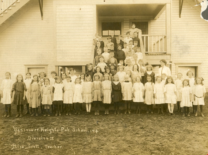
Vancouver Heights Public School
https://search.heritageburnaby.ca/link/museumdescription20
- Repository
- Burnaby Village Museum
- Date
- 1912
- Collection/Fonds
- Burnaby Village Museum Photograph collection
- Description Level
- Item
- Physical Description
- 1 photograph : sepia ; 15.4 x 20.4 cm
- Scope and Content
- Photograph of Miss Scott's Division II class standing on the steps (as well as spread out in front) of Vancouver Heights Public School. Miss Scott is wearing a white blouse and a tie with her hair parted in the middle and pulled back. She is standing to the right in the third row. Most of the girls…
- Repository
- Burnaby Village Museum
- Collection/Fonds
- Burnaby Village Museum Photograph collection
- Description Level
- Item
- Physical Description
- 1 photograph : sepia ; 15.4 x 20.4 cm
- Scope and Content
- Photograph of Miss Scott's Division II class standing on the steps (as well as spread out in front) of Vancouver Heights Public School. Miss Scott is wearing a white blouse and a tie with her hair parted in the middle and pulled back. She is standing to the right in the third row. Most of the girls are wearing loose-fitting cotton dresses tied at the waist and cut just above the kneecap. The boys are wearing shirts buttoned right to the collar and sweaters. At least two boys are in sailor suits.
- Subjects
- Occupations - Teachers
- Geographic Access
- Gilmore Avenue
- Street Address
- 50 Gilmore Avenue
- Accession Code
- HV971.23.1
- Access Restriction
- No restrictions
- Reproduction Restriction
- No known restrictions
- Date
- 1912
- Media Type
- Photograph
- Historic Neighbourhood
- Vancouver Heights (Historic Neighbourhood)
- Planning Study Area
- Burnaby Heights Area
- Related Material
- For another print of the same image, see BV989.19.3
- Scan Resolution
- 600
- Scan Date
- 2023-03-21
- Notes
- Title based on caption of photograph
- Annotation on the lower left of the photograph reads: "Vancouver Heights Pub. School, 1912. / Division II / Miss Scott, Teacher."
- Note written in pencil on verso of the photograph reads: "Mr. Tom Browning."
Images
![Vancouver street view, [191-] thumbnail](/media/hpo/_Data/_BVM_Images/2022/2022_0032_0136_001.jpg?width=280)
Vancouver street view
https://search.heritageburnaby.ca/link/museumdescription19714
- Repository
- Burnaby Village Museum
- Date
- [191-]
- Collection/Fonds
- Esther Love Stanley fonds
- Description Level
- Item
- Physical Description
- 1 photograph : b&w ; 8 x 10.5 cm
- Scope and Content
- Photograph looking south down Granville Street in Vancouver. Lamp post in foreground with shops and businesses visible on either side of the street. W.C. Stearman's hardware store is visible in the foreground to the right.
- Repository
- Burnaby Village Museum
- Collection/Fonds
- Esther Love Stanley fonds
- Description Level
- Item
- Physical Description
- 1 photograph : b&w ; 8 x 10.5 cm
- Scope and Content
- Photograph looking south down Granville Street in Vancouver. Lamp post in foreground with shops and businesses visible on either side of the street. W.C. Stearman's hardware store is visible in the foreground to the right.
- Geographic Access
- Vancouver
- Accession Code
- BV022.32.136
- Access Restriction
- No restrictions
- Reproduction Restriction
- No known restrictions
- Date
- [191-]
- Media Type
- Photograph
- Scan Resolution
- 600
- Scan Date
- 2023-04-04
- Notes
- Title based on contents of photograph
- Photograph is part of Esther Love Stanley photograph album 1 (BV022.32.1)
Images
![Vancouver street view, [191-] thumbnail](/media/hpo/_Data/_BVM_Images/2022/2022_0032_0136_001.jpg)
![CP 3456 at Drake Street Yard, [after 1906] thumbnail](/media/hpo/_Data/_BVM_Images/1985/1985_6114_0065_001.jpg?width=280)
CP 3456 at Drake Street Yard
https://search.heritageburnaby.ca/link/museumdescription3293
- Repository
- Burnaby Village Museum
- Date
- [after 1906]
- Collection/Fonds
- Burnaby Village Museum Photograph collection
- Description Level
- Item
- Physical Description
- 1 photograph : b&w ; 5.5 x 8 cm
- Scope and Content
- Photograph of Canadian Pacific Railway steam locomotive no. 3456 (built in 1906) at Drake Street Yard in Vancouver.
- Repository
- Burnaby Village Museum
- Collection/Fonds
- Burnaby Village Museum Photograph collection
- Description Level
- Item
- Physical Description
- 1 photograph : b&w ; 5.5 x 8 cm
- Scope and Content
- Photograph of Canadian Pacific Railway steam locomotive no. 3456 (built in 1906) at Drake Street Yard in Vancouver.
- Geographic Access
- Vancouver
- Accession Code
- BV985.6114.65
- Access Restriction
- No restrictions
- Reproduction Restriction
- No known restrictions
- Date
- [after 1906]
- Media Type
- Photograph
- Scan Resolution
- 600
- Scan Date
- 2024-03-19
- Notes
- Title based on note written on verso of photograph
- Handwritten note in black ball-point pen on verso of photograph reads: "CP 3456/ Drake St Yard"
- Stamp on verso of photograph reads: "068"
Images
![CP 3456 at Drake Street Yard, [after 1906] thumbnail](/media/hpo/_Data/_BVM_Images/1985/1985_6114_0065_001.jpg)
![Dr. Sun Yat-Sen, [between 1910 and 1911] thumbnail](/media/hpo/_Data/_BVM_Images/1974/197500050060.jpg?width=280)
Dr. Sun Yat-Sen
https://search.heritageburnaby.ca/link/museumdescription3054
- Repository
- Burnaby Village Museum
- Date
- [between 1910 and 1911]
- Collection/Fonds
- Way Sang Yuen Wat Kee & Co. fonds
- Description Level
- Item
- Physical Description
- 1 photograph : sepia ; 23 x 18 cm, mounted on card 35 x 30 cm
- Scope and Content
- Photograph of Dr. Sun Yat-sen taken in Yucho Chow's photographic studio in Vancouver. While traveling the world to raise awareness of, and funding for, the Chinese nationalist movement, Sun Yat-sen stayed in Vancouver on three different occasions for extended periods. This framed photograph hung o…
- Repository
- Burnaby Village Museum
- Collection/Fonds
- Way Sang Yuen Wat Kee & Co. fonds
- Description Level
- Item
- Physical Description
- 1 photograph : sepia ; 23 x 18 cm, mounted on card 35 x 30 cm
- Material Details
- Photographer's mark on recto of card mount reads: "Yucho Chow Studio, Vancouver"
- Scope and Content
- Photograph of Dr. Sun Yat-sen taken in Yucho Chow's photographic studio in Vancouver. While traveling the world to raise awareness of, and funding for, the Chinese nationalist movement, Sun Yat-sen stayed in Vancouver on three different occasions for extended periods. This framed photograph hung on the wall inside the original Way Sang Yuen Wat Kee & Company shop in Victoria.
- Geographic Access
- Vancouver
- Accession Code
- HV975.5.60
- Access Restriction
- No restrictions
- Reproduction Restriction
- No known restrictions
- Date
- [between 1910 and 1911]
- Media Type
- Photograph
- Scan Resolution
- 600
- Scan Date
- 1/6/2010
- 15-Jun-2018
- Scale
- 100
- Photographer
- Yucho Chow Studio
- Notes
- Title based on contents of photograph
Images
![Dr. Sun Yat-Sen, [between 1910 and 1911] thumbnail](/media/hpo/_Data/_BVM_Images/1974/197500050060.jpg)
![Edwin Wettenhall Bateman, [between 1910 and 1921] thumbnail](/media/hpo/_Data/_BVM_Images/1990/199400220005.jpg?width=280)
Edwin Wettenhall Bateman
https://search.heritageburnaby.ca/link/museumdescription1198
- Repository
- Burnaby Village Museum
- Date
- [between 1910 and 1921]
- Collection/Fonds
- E.W. Bateman family fonds
- Description Level
- Item
- Physical Description
- 1 photograph : b&w ; 13.5 x 8 cm
- Scope and Content
- Photograph of Edwin Wettenhall Bateman in front of his 7th Avenue home in Vancouver. He is dressed in a suit and hat and is holding a cane in his right hand. A Jack Russell terrier is lying on the lawn beside him.
- Repository
- Burnaby Village Museum
- Collection/Fonds
- E.W. Bateman family fonds
- Description Level
- Item
- Physical Description
- 1 photograph : b&w ; 13.5 x 8 cm
- Scope and Content
- Photograph of Edwin Wettenhall Bateman in front of his 7th Avenue home in Vancouver. He is dressed in a suit and hat and is holding a cane in his right hand. A Jack Russell terrier is lying on the lawn beside him.
- Subjects
- Animals - Dogs
- Names
- Bateman, Edwin W.
- Geographic Access
- Vancouver
- Accession Code
- BV994.22.5
- Access Restriction
- No restrictions
- Reproduction Restriction
- No known restrictions
- Date
- [between 1910 and 1921]
- Media Type
- Photograph
- Scan Resolution
- 600
- Scan Date
- 01-Jun-09
- Scale
- 100
- Notes
- Title based on contents of photograph
Images
![Edwin Wettenhall Bateman, [between 1910 and 1921] thumbnail](/media/hpo/_Data/_BVM_Images/1990/199400220005.jpg)
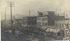
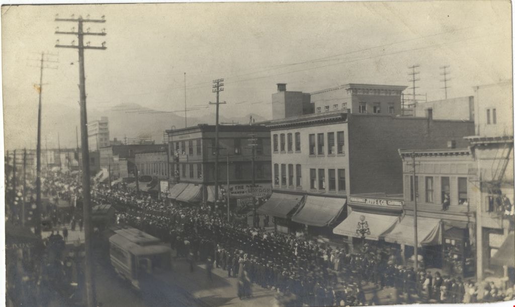
Funeral procession of late Chief MacLennan
https://search.heritageburnaby.ca/link/museumdescription3521
- Repository
- Burnaby Village Museum
- Date
- 14 Mar. 1917
- Collection/Fonds
- Burnaby Village Museum Photograph collection
- Description Level
- Item
- Physical Description
- 1 photograph : b&w ; 8 x 13.5 cm
- Scope and Content
- Photograph of funeral procession for Police Chief MacLennan proceeding down Main Street in Vancouver. The funeral procession also included the remains of young George Robb, an eight year old boy who was also murdered by the same assailant. Intersection of Main Street and East Georgia, looking north…
- Repository
- Burnaby Village Museum
- Collection/Fonds
- Burnaby Village Museum Photograph collection
- Description Level
- Item
- Physical Description
- 1 photograph : b&w ; 8 x 13.5 cm
- Scope and Content
- Photograph of funeral procession for Police Chief MacLennan proceeding down Main Street in Vancouver. The funeral procession also included the remains of young George Robb, an eight year old boy who was also murdered by the same assailant. Intersection of Main Street and East Georgia, looking northeast from the west side of the 700 block to the 600 block of Main Street at the east end of the old Georgia viaduct. A large crowd has gathered along the street and Streetcars are visible.
- Subjects
- Events - Parades
- Geographic Access
- Vancouver
- Accession Code
- HV975.33.3ah
- Access Restriction
- No restrictions
- Date
- 14 Mar. 1917
- Media Type
- Photograph
- Scan Resolution
- 600
- Scan Date
- 2/2/2010
- Scale
- 100
- Notes
- Title based on contents of photograph
- Image from personal photograph album of Tom "Tommy" Irvine (HV975.33.3)
Images
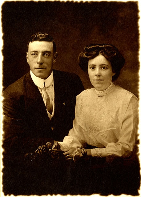
![George and Harriet Jeffery, [between 1910 and 1913] thumbnail](/media/hpo/_Data/_BVM_Images/1971/1971_0144_0007_001.jpg?width=280)
George and Harriet Jeffery
https://search.heritageburnaby.ca/link/museumdescription40
- Repository
- Burnaby Village Museum
- Date
- [between 1910 and 1913]
- Collection/Fonds
- Burnaby Village Museum Photograph collection
- Description Level
- Item
- Physical Description
- 1 photograph : sepia ; 9.9 x 14.0 cm photogravure on paper 21.5 x 16.4 cm
- Scope and Content
- Photogravure of George Jeffery and his wife Harriet. George Jeffery is dressed in a dark suit with light vest and striped shirt, a celluloid collar, a narrow striped necktie, and a pin in the left lapel. Harriet Jeffery is wearing a white trimmed and embroidered Gibson-style blouse, with a pin at t…
- Repository
- Burnaby Village Museum
- Collection/Fonds
- Burnaby Village Museum Photograph collection
- Description Level
- Item
- Physical Description
- 1 photograph : sepia ; 9.9 x 14.0 cm photogravure on paper 21.5 x 16.4 cm
- Scope and Content
- Photogravure of George Jeffery and his wife Harriet. George Jeffery is dressed in a dark suit with light vest and striped shirt, a celluloid collar, a narrow striped necktie, and a pin in the left lapel. Harriet Jeffery is wearing a white trimmed and embroidered Gibson-style blouse, with a pin at the neck. She is holding flowers as studio props. According to the earlier catalogue record from 1976, the photogravure was made shortly after the couple's wedding. Embossed on the photogravure, front, lower left: "WJC [monogram]" and lower right: "Carpenter / Vancouver. B.C." Inscribed in pencil, back of the photogravure: "5699 / George / Jeffry. [sic] / 4531 Burke St. / Vancouver / B.C."
- Geographic Access
- Vancouver
- Accession Code
- HV971.144.7
- Access Restriction
- No restrictions
- Reproduction Restriction
- No known restrictions
- Date
- [between 1910 and 1913]
- Media Type
- Photograph
- Scan Resolution
- 600
- Scan Date
- 2023-03-28
- Photographer
- Carpenter, William Jefferson
- Notes
- Title based on contents of photograph
Images
![George and Harriet Jeffery, [between 1910 and 1913] thumbnail](/media/hpo/_Data/_BVM_Images/1971/1971_0144_0007_001.jpg)