![Elsie Brown-John (bottom, far right) with her class at Kitchener Street School, [1936]. Item no. 549-001. thumbnail](/media/hpo/_Data/_Archives_Images/_Unrestricted/540/549-001.jpg?width=280)
Interview with Elsie Ansdell by Eric Damer September 18, 2012 - Track 4
https://search.heritageburnaby.ca/link/oralhistory290
- Repository
- City of Burnaby Archives
- Date Range
- 1927-1938
- Length
- 0:08:14
- Summary
- This portion of the recording pertains to Elsie (Brown-John) Ansdell's early memories of recreational activities and daily life as a young person in Burnaby (activities include swimming, skating and going to the movies). She mentions Frank Walsh's Garage and discusses photographs of Brown-John Truc…
- Repository
- City of Burnaby Archives
- Summary
- This portion of the recording pertains to Elsie (Brown-John) Ansdell's early memories of recreational activities and daily life as a young person in Burnaby (activities include swimming, skating and going to the movies). She mentions Frank Walsh's Garage and discusses photographs of Brown-John Trucking, "the blasting stump" and Burns Acreage.
- Date Range
- 1927-1938
- Photo Info
- Elsie Brown-John (bottom, far right) with her class at Kitchener Street School, [1936]. Item no. 549-001.
- Length
- 0:08:14
- Subjects
- Recreational Activities - Swimming
- Historic Neighbourhood
- Vancouver Heights (Historic Neighbourhood)
- Interviewer
- Damer, Eric
- Interview Date
- September 18, 2012
- Scope and Content
- Recording is an interview with early Burnaby resident Elsie (Brown-John) Ansdell conducted by Burnaby Village Museum employee Eric Damer, September 18, 2012. Major themes discussed are: settling in Burnaby and the early years of the Brown-John family.
- Biographical Notes
- Elsie (Brown-John) Ansdell’s father, a trained carpenter and cabinet maker, Victor Brown-John came to Canada from Wales in 1910. He cleared three lots at Napier and Gilmore Streets and built a two-roomed house. In 1912, he was joined by his wife and two eldest sons, Victor and Archie. Twin boys, Frank and Roy, were born in 1914 in the Burnaby home and their fifth son, Clive, was born in 1915. From 1916 to 1919 Victor John-Brown left Burnaby to serve overseas. Elsie Brown-John (later Ansdell) was born in 1921. Her younger brother, Gwyn "Jerry" was born in 1923. In 1925 Victor Brown-John suffered a fatal accident while working as a longshoreman in Northern British Columbia. Elsie attended Kitchener Elementary and North Burnaby High School. She married during the Second World War and moved to South Burnaby to raise her family whilst continuing to work in various department stores both in Vancouver and Burnaby.
- Total Tracks
- 4
- Total Length
- 33:02
- Interviewee Name
- Ansdell, Elsie Brown-John
- Interview Location
- Burnaby Village Museum
- Interviewer Bio
- Eric Damer is a lifelong British Columbian born in Victoria, raised in Kamloops, and currently residing in Burnaby. After studying philosophy at the University of Victoria, he became interested in the educational forces that had shaped his own life. He completed master’s and doctoral degrees in educational studies at the University of British Columbia with a particular interest in the history of adult and higher education in the province. In 2012, Eric worked for the City of Burnaby as a field researcher and writer, conducting interviews for the City Archives and Museum Oral History Program.
- Collection/Fonds
- Community Heritage Commission Special Projects fonds
- Transcript Available
- None
- Media Type
- Sound Recording
Images
![Elsie Brown-John (bottom, far right) with her class at Kitchener Street School, [1936]. Item no. 549-001. thumbnail](/media/hpo/_Data/_Archives_Images/_Unrestricted/540/549-001.jpg)
Audio Tracks
Track four of recording of interview with Elsie Ansdell
Track four of recording of interview with Elsie Ansdell
https://search.heritageburnaby.ca/media/hpo/_Data/_Archives_Oral_Histories/_Unrestricted/MSS171-001/MSS171-001_Track_4.mp3Interview with Jenny Siormanolakis
https://search.heritageburnaby.ca/link/museumdescription19635
- Repository
- Burnaby Village Museum
- Date
- [1960-2023] (interview content), interviewed 26 Jul. 2023
- Collection/Fonds
- Burnaby Village Museum fonds
- Description Level
- Item
- Physical Description
- 2 sound recordings (wav) (87 min.) + 1 sound recording (mp3) (86 min., 51 sec.)
- Scope and Content
- Item consists of a recording of an oral history interview with Jenny (Eugenia) Siormanolakis conducted by Burnaby Village Museum Registrar, James Binks on July 26 2023. 00:00-12:02 Interview opens with introductions. Jenny Siormanolakis shares details about her parents Eugene and Europe Siormanola…
- Repository
- Burnaby Village Museum
- Collection/Fonds
- Burnaby Village Museum fonds
- Series
- Museum Oral Histories series
- Subseries
- Many Voices Project Interviews subseries
- Description Level
- Item
- Physical Description
- 2 sound recordings (wav) (87 min.) + 1 sound recording (mp3) (86 min., 51 sec.)
- Material Details
- Interviewer: James Binks Interviewee: Jenny (Eugenia) Siormanolakis Location of Interview: Prado Cafe, 4321 Still Creek Dr., Burnaby Interview Date: July 26, 2023 Total Number of tracks: 2 Total Length of all Tracks: 01:26:60 Digital master recordings (wav) were recorded onto two separate audio tracks, edited and merged together and converted to mp3 for access on Heritage Burnaby Ambient sound from cafe in background of interview
- Scope and Content
- Item consists of a recording of an oral history interview with Jenny (Eugenia) Siormanolakis conducted by Burnaby Village Museum Registrar, James Binks on July 26 2023. 00:00-12:02 Interview opens with introductions. Jenny Siormanolakis shares details about her parents Eugene and Europe Siormanolakis who were both born in Greece and immigrated to Vancouver. Jenny provides details about the history of Romana Pizza restaurant including; the restaurant partners, the various locations, her father’s work ethics of running the restaurant and the staff who worked there. Jenny provides details about her father's life, his ancestral background and family relations which lead him to immigrate to Vancouver. Jenny shares childhood memories of helping out in her parents’ restaurant and later working there. 12:03 – 26:41 Jenny describes various food dishes that have been on the menu of Romana Pizza and Steak House and Romana Pizza, how they've evolved over time, how her father learned to cook traditional Greek food and develop his own recipes and where he sourced his restaurant food supplies. Jenny conveys how they used social media to advertise the restaurant, describes the election pizza poll that Romana Pizza held during the federal and provincial elections and a baby poll that was held at the restaurant to guess the weight of her and her sister’s babies. 26:42 – 31:47 Jenny talks about her marriage and recollects how she got married in a civil ceremony at Romana Pizza. Jenny talks about her family life while her family was running the restaurant, their decision to sell the restaurant and describes the last days of running the restaurant. 31:48 – 46:33 Jenny conveys the background story of her business “Granpa J’s”. Jenny describes how her uncle Jimmy Voulides, created his own seasoning salt product and after he died in 2003, Jenny and her sister Nora purchased the business. Jenny describes how they developed their business, created new products, their struggles and how they became successful. Jenny describes how their products have been developed from family recipes and recalls how the actor Ryan Reynold’s helped their products become even more successful overnight. 46:34 – 55:38 Jenny talks about different community festivals and events that she’s been involved with including; Greek Day on Broadway (Vancouver) and the Hats Off Day event in North Burnaby. Jenny shares the background history of Greek Day in Vancouver and information about other Greek community events. Jenny talks about the importance of bringing the community together and the importance of knowing the history of your ancestors and where they came from. 55:39 - 1:04:35 Jenny talks about her involvement with the Greek community newspaper “Gnome” and provides details about; the former creator and editor Kostas Karatsikis, the newspaper's content, it's importance in the Greek community and the distribution. Jenny describes some of the articles that she’s written for the Gnome newspaper. 1:04:36 - 1:14:12 Jenny describes some pivotal moments that occurred over the years at Romana Pizza including; placing second in the Vancouver Sun newspaper contest for Best Pizza (1986) and having members of the Vancouver Canucks hockey team frequent their restaurant. Jenny conveys how the restaurant benefited from having a website and using social media as a marketing tools. 1:14:13 - 1:22:42 Jenny talks about her involvement with Kolanki Group West, Euro Find foods and her passion for Greek food and other European foods. Jenny describes some traditional Greek recipes, family recipes, talks about marketing Grandpa J's products and reflects on the menu of Romana Pizza. 1:22:43 - 1:26:51 Jenny reflects on the role of the Greek community, how food plays a roll, the future of the Greek community in Vancouver and Burnaby and the importance of engaging the younger generation. In closing Jenny provides a quote from an article that she wrote “Forgive the mistakes of the past, let it go and realize that we are all equals...”.
- History
- Interviewee biography: Eugenia "Jenny" Siormanolakis is the daughter of Eugene and Europe Siormanolakis. Jenny’s father, Eugene Siormanolakis immigrated to Canada from Greece in the late 1960’s and her mother Europe Siormanolakis immigrated in 1973. In April 1973, her father and five partners opened the restaurant “Romana Pizza and Steak House” (later renamed "Romana Pizza") located at 4660 Hastings Street in the Burnaby Heights neighbourhood. Jenny and her sister Eleanora Iliakis spent much of their childhood in the family owned restaurant and also worked at the restaurant as they become older. Jenny’s parents continued to own and operate the restaurant until 2014 when they decided to retire from the business. In 2004, an opportunity arose for Jenny and her sister Eleanora to buy their recently deceased uncle’s business Grandpa J’s Seasoning Inc. They launched their business of “Grandpa J’s” seasoning first selling to local restaurants and eventually adapted their product line to include other Greek seasoning products which they developed from their own recipes. They expanded their clientele to include retail outlets and in 2020, they got a boost to their sales when actor Ryan Reynolds promoted their seasoing product "Vancity Grind" on Instagram. Since launching their business they have been featured in many culinary and business publications and were nominated in 2022 as finalists for Product of the Year by BC Food and Beverage. Jenny is extremely passionate about food, her Greek heritage and is an advocate for food security for children and seniors and mental health. Interviewer biography: James Binks has lived in the Lower Mainland since 2009 after relocating from Ontario. James holds a Bachelor of Arts in Anthropology from the University of British Columbia, where he conducted researched on heritage, environment, and globalization in India, Nepal, and Italy. At Burnaby Village Museum, James contributed to the exhibit “Truths Not Often Told: Being South Asian in Burnaby”.
- Creator
- Burnaby Village Museum
- Subjects
- Buildings - Commercial - Restaurants
- Businesses
- Elections
- Foods
- Migration
- Occupations - Entrepreneurs
- Persons - Greek Canadians
- Names
- Gnome Publications
- Iliakis, Eleonara Siormanolakis
- Karatsikis, Kostas "George"
- Siormanolakis, Eugenia "Jenny"
- Nikolaidis, "Eleni"
- Nikolaidis, Stelios
- Romana Pizza
- Siormanolakis, Eugene
- Siormanolakis, Europe
- Voulides, Demetrios "Jimmy"
- Responsibility
- Binks, James
- Geographic Access
- Hastings Street
- Street Address
- 4660 Hastings Street
- Accession Code
- BV023.16.13
- Access Restriction
- No restrictions
- Reproduction Restriction
- No known restrictions
- Date
- [1960-2023] (interview content), interviewed 26 Jul. 2023
- Media Type
- Sound Recording
- Historic Neighbourhood
- Vancouver Heights (Historic Neighbourhood)
- Planning Study Area
- Burnaby Heights Area
- Notes
- Title based on contents of item
- Transcription available on Heritage Burnaby
Documents
Audio Tracks
Interview with Jenny Siormanolakis, [1960-2023] (interview content), interviewed 26 Jul. 2023
Interview with Jenny Siormanolakis, [1960-2023] (interview content), interviewed 26 Jul. 2023
https://search.heritageburnaby.ca/media/hpo/_Data/_BVM_Sound_Recordings/Oral_Histories/2023_0016_0013_003.mp3Interview with John Ferguson July 3, 1975 - Track 1
https://search.heritageburnaby.ca/link/oralhistory180
- Repository
- City of Burnaby Archives
- Date Range
- 1900-1939
- Length
- 0:08:23
- Summary
- This portion of the interview pertains to John Ferguson's memories of first coming to Burnaby in 1931. He describes the neighbourhood of Vancouver Heights and the people that lived there. He also describes the types of goods he sold at his Vancouver Heights Hardware Store.
- Repository
- City of Burnaby Archives
- Summary
- This portion of the interview pertains to John Ferguson's memories of first coming to Burnaby in 1931. He describes the neighbourhood of Vancouver Heights and the people that lived there. He also describes the types of goods he sold at his Vancouver Heights Hardware Store.
- Date Range
- 1900-1939
- Length
- 0:08:23
- Historic Neighbourhood
- Vancouver Heights (Historic Neighbourhood)
- Interviewer
- McLeod, Ross S.
- Interview Date
- July 3, 1975
- Scope and Content
- Recording is of an interview with John Ferguson by history student Ross S. McLeod, July 3, 1975. Major themes discussed are: the Depression.
- Biographical Notes
- John Ferguson was born in Glasgow in 1900. He came to Canada with his family in 1910, and settled on Vancouver Island. In 1931 John Ferguson purchased the hardware store on the 3900 block of Hastings Street.
- Total Tracks
- 4
- Total Length
- 0:32:21
- Interviewee Name
- Ferguson, John
- Collection/Fonds
- Burnaby Historical Society fonds
- Subseries
- Oral history subseries
- Media Type
- Sound Recording
- Web Notes
- Interview was digitized in 2010 allowing it to be accessible on Heritage Burnaby. The digitization project was initiated by the Community Heritage Commission with support from City of Burnaby Council and the BC History Digitization Program of the Irving K. Barber Learning Centre, University of British Columbia. It was recognized by the Heritage Society of BC with an award in 2012.
Audio Tracks
Track one of interview with John Ferguson
Track one of interview with John Ferguson
https://search.heritageburnaby.ca/media/hpo/_Data/_Archives_Oral_Histories/_Unrestricted/100-13-18/100-13-18_Track_1.mp3
Interview with Sev Morin by Rod Fowler April 4, 1990 - Track 2
https://search.heritageburnaby.ca/link/oralhistory538
- Repository
- City of Burnaby Archives
- Date Range
- 1950-1990
- Length
- 00:06:16
- Summary
- This portion of the interview is about Sev Morin’s description of Burnaby’s growth and business development along Kingsway and Hastings, the Lake City Industrial Park, and the purchase of property in 1958 for the Heritage Park and Art Gallery.
- Repository
- City of Burnaby Archives
- Summary
- This portion of the interview is about Sev Morin’s description of Burnaby’s growth and business development along Kingsway and Hastings, the Lake City Industrial Park, and the purchase of property in 1958 for the Heritage Park and Art Gallery.
- Date Range
- 1950-1990
- Photo Info
- Sev Morin (left) of Severin's in Burnaby (formerly the Gai Paree) hosting a gala New Year's celebration, 1979. Item no. 480-712
- Length
- 00:06:16
- Subjects
- Buildings - Commercial
- Buildings - Civic
- Buildings - Industrial
- Buildings - Schools - Universities and Colleges
- Historic Neighbourhood
- Central Park (Historic Neighbourhood)
- Burnaby Lake (Historic Neighbourhood)
- Vancouver Heights (Historic Neighbourhood)
- Edmonds (Historic Neighbourhood)
- Planning Study Area
- Burnaby Heights Area
- Lake City Area
- Burnaby Mountain Area
- Kingsway-Beresford Area
- Douglas-Gilpin Area
- Interviewer
- Fowler, Rod
- Interview Date
- April 4, 1990
- Scope and Content
- Recording is of an interview with Severin "Sev" Morin, conducted by Rod Fowler. Sev Morin was one of eleven participants interviewed as part of the SFU/Burnaby Centennial Committee's oral history series titled, "Voices of Burnaby". The interview is mainly about Sev Morin’s banquet hall, restaurant and night club business on Kingsway, originally named the “Gai Paree Supper Club” (1947-1976) and later “Severin’s” (1976-1985) and “Diego’s” (1985-1994), its function as a Burnaby landmark, and the entertainment and political people he met through his business. He also describes his many volunteer activities in Burnaby, including member of the SFU Senate, Rotary Club, Variety Club and Telethon, fund raising for Burnaby Hospital, and tourism related groups, and his political work for the federal Liberal party. He talks about his parents’ origins, the lives of his brothers Rudy and Rene, and the family’s involvement in establishing the “Gai Paree”. He also shares his views about the business and cultural development of Burnaby. To view “Narrow By” terms for each track expand this description and see “Notes”.
- Biographical Notes
- Severin “Sev” Rene Morin was born September 21, 1927, in Bonneville, Alberta, to Rene Pierre Morin (1878-1963) and Anne Marie (nee Lachiver) Morin (1886-1956). Mr. and Mrs. R. P. Morin and their son Rene Francois (1905-1954) immigrated to Edmonton, Alberta, from France in 1913, where Rene Pierre Morin worked for the C.N.R. and a second son Adolphe “Rudy” Ferdinand (1922-1969) was born, followed by their third son Severin. In 1943, after R.P. Morin retired, the family moved to Burnaby to a house on Sperling Avenue. Sometime earlier the two older Morin brothers found work in Trail at the smelter and developed musical careers. In 1946/47 the Morin family purchased property on Kingsway and built a banquet hall, the “Gai Paree Supper Club”. Sev and Rudy Morin managed the club and Rene F. Morin moved to Burnaby to join them with his band. The supper club, with its live music and dance floor, became a popular meeting place and wedding venue, eventually expanding into a restaurant and nightclub in the 1970s. The “Gai Paree” was renamed “Severin’s” in 1976 and “Diego’s” in 1985, closing finally in 1994. Sev Morin’s business life included three record stores which he owned with his friend Jack Cullen. Through these businesses Sev Morin was well known in the entertainment and hospitality industry. He and his restaurant also hosted political and social events that made the restaurant a community landmark. Sev Morin contributed many volunteer hours to community and charitable organizations, including an appointment to the SFU Senate, fundraising for the Burnaby Hospital, Director of the Variety Club and Rotary Club, and consultant for a variety of tourism related ventures. He also was active in the federal Liberal Party. Sev Morin and his wife Pauline married in 1950 and had three children. Sev Morin died at age 86 on March 28, 2014.
- Total Tracks
- 10
- Total Length
- 00:56:44
- Interviewee Name
- Morin, Severin "Sev"
- Interviewer Bio
- Rod Fowler returned to university as a mature student in the 1980s after working about twenty years in the field of economics and computerization in business in England, Europe and Western Canada. He graduated with a BA from SFU in both History and Sociology in 1987, his MA degree in Geography in 1989, and his PhD in Cultural Geography at SFU. He taught courses in Geography, Sociology, History and Canadian Studies at several Lower Mainland colleges, before becoming a full time member of the Geography Department at Kwantlen University College.
- Collection/Fonds
- SFU/Burnaby Centennial Committee fonds
- Transcript Available
- Transcript available
- Media Type
- Sound Recording
- Web Notes
- Interviews were digitized in 2015 allowing them to be accessible on Heritage Burnaby. The digitization project was initiated by the Community Heritage Commission with support from City of Burnaby Council.
Images

Audio Tracks
Track two of interview with Sev Morin
Track two of interview with Sev Morin
https://search.heritageburnaby.ca/media/hpo/_Data/_Archives_Oral_Histories/_Unrestricted/MSS187-021/MSS187-021_Track%202.mp3Interview with Toki Miyashita by Rod Fowler February 27, 1990 - Track 3
https://search.heritageburnaby.ca/link/oralhistory518
- Repository
- City of Burnaby Archives
- Date Range
- 1969-1990
- Length
- 00:04:54
- Summary
- This portion of the interview is about Toki Miyashita and her family’s move to Burnaby in 1969 to an apartment near Brentwood Mall. She tells about continuing to demonstrate origami in schools and teach Ikebana in the community.
- Repository
- City of Burnaby Archives
- Summary
- This portion of the interview is about Toki Miyashita and her family’s move to Burnaby in 1969 to an apartment near Brentwood Mall. She tells about continuing to demonstrate origami in schools and teach Ikebana in the community.
- Date Range
- 1969-1990
- Length
- 00:04:54
- Subjects
- Persons - Volunteers
- Arts
- Historic Neighbourhood
- Vancouver Heights (Historic Neighbourhood)
- Planning Study Area
- Brentwood Area
- Interviewer
- Fowler, Rod
- Interview Date
- February 27, 1990
- Scope and Content
- Recording is of an interview with Toki Miyashita, conducted by Rod Fowler. Toki Miyashita was one of eleven participants interviewed as part of the SFU/Burnaby Centennial Committee's oral history series titled, "Voices of Burnaby". The interview is about Toki Miyashita’s family’s internment during WWII, her awakening interest in Japanese culture after the war, her subsequent interest in teaching others about Japanese crafts and arts, and becoming a helpful intermediary between Burnaby and visitors from Japan. The interview explores her interest in the Ainu of Japan and their possible link to the aboriginals of BC, her impressions of the Ainu carver Nuburi Toko, and her involvement in the events surrounding the creation of the sculpture “Playground of the Gods” for Burnaby Mountain. The interview also contains interesting details about the art of Japanese flower-arranging. To view “Narrow By” terms for each track expand this description and see “Notes”.
- Biographical Notes
- Toki Miyashita was born in Richmond B.C., ca. 1935, at the Nelson Brothers “fishery”, a second generation Canadian descended from the Oikawa family who settled on Don and Lion Islands (Oikawa-shima). In 1942 the Japanese Canadians in BC were forcibly moved from the coast and their belongings confiscated. Toki Miyashita, her parents, two brothers, and grandparents were first taken to Hastings Park where her father was separated from the family to work in road camps, and the rest of the family were interned in New Denver. Her resourceful grandmother moved the family to land outside the internment camp, growing a large garden from seeds brought with her. In 1946 the family moved to Kamloops and in 1958, after finishing high school, Toki Miyashita moved to Montreal to be with relatives and a small Japanese community. At this time she became interested in Japanese culture and took a Japanese language course at age 22. She learned about Japanese flower-arranging (Ikebana), paper folding (Origami), silk doll making (from a Russian Jew), and how to wear a kimono. She began demonstrating these arts in schools and to other groups, which she continued doing when she, her husband and two young children moved to Burnaby in 1969. Toki Miyashita has been called an unpaid “ambassador” of Japanese culture to the Lower Mainland. She has acted as liaison between Burnaby and her sister city Kushiro in Japan, which involved her in the creation of the Ainu sculpture “Playground of the Gods” on Burnaby Mountain for Burnaby’s Centennial. Toki Miyashita is a recognized Master in Ikebana Sogetsu, a school of flower-arranging, and has served on the board of the Vancouver Ikebana Association. She also served on Burnaby’s Family Court in the 1980s.
- Total Tracks
- 11
- Total Length
- 01:34:10
- Interviewee Name
- Miyashita, Toki
- Interviewer Bio
- Rod Fowler returned to university as a mature student in the 1980s after working about twenty years in the field of economics and computerization in business in England, Europe and Western Canada. He graduated with a BA from SFU in both History and Sociology in 1987, his MA degree in Geography in 1989, and his PhD in Cultural Geography at SFU. He taught courses in Geography, Sociology, History and Canadian Studies at several Lower Mainland colleges, before becoming a full time member of the Geography Department at Kwantlen University College.
- Collection/Fonds
- SFU/Burnaby Centennial Committee fonds
- Transcript Available
- Transcript available
- Media Type
- Sound Recording
- Web Notes
- Interviews were digitized in 2015 allowing them to be accessible on Heritage Burnaby. The digitization project was initiated by the Community Heritage Commission with support from City of Burnaby Council.
Audio Tracks
Track three of interview with Toki Miyashita
Track three of interview with Toki Miyashita
https://search.heritageburnaby.ca/media/hpo/_Data/_Archives_Oral_Histories/_Unrestricted/MSS187-017/MSS187-017_Track_3.mp3![Jack Warren, [1920] (date of original), copied 1986 thumbnail](/media/hpo/_Data/_Archives_Images/_Unrestricted/204/204-399.jpg?width=280)
Jack Warren
https://search.heritageburnaby.ca/link/archivedescription35541
- Repository
- City of Burnaby Archives
- Date
- [1920] (date of original), copied 1986
- Collection/Fonds
- Burnaby Historical Society fonds
- Description Level
- Item
- Physical Description
- 1 photograph : b&w ; 12.7 x 17.8 cm print
- Scope and Content
- Photograph of John "Jack" Warren behind his home at 4264 Union Street. He died prematurely from First World War gassing.
- Repository
- City of Burnaby Archives
- Date
- [1920] (date of original), copied 1986
- Collection/Fonds
- Burnaby Historical Society fonds
- Subseries
- Pioneer Tales subseries
- Physical Description
- 1 photograph : b&w ; 12.7 x 17.8 cm print
- Description Level
- Item
- Record No.
- 204-399
- Access Restriction
- No restrictions
- Reproduction Restriction
- No known restrictions
- Accession Number
- BHS1988-03
- Scope and Content
- Photograph of John "Jack" Warren behind his home at 4264 Union Street. He died prematurely from First World War gassing.
- Names
- Warren, John "Jack"
- Media Type
- Photograph
- Notes
- Title based on contents of photograph
- Geographic Access
- Union Street
- Street Address
- 4264 Union Street
- Historic Neighbourhood
- Vancouver Heights (Historic Neighbourhood)
- Planning Study Area
- Willingdon Heights Area
Images
![Jack Warren, [1920] (date of original), copied 1986 thumbnail](/media/hpo/_Data/_Archives_Images/_Unrestricted/204/204-399.jpg)
Joe and Mina Wright
https://search.heritageburnaby.ca/link/archivedescription35405
- Repository
- City of Burnaby Archives
- Date
- 1929 (date of original), copied 1986
- Collection/Fonds
- Burnaby Historical Society fonds
- Description Level
- Item
- Physical Description
- 1 photograph : b&w ; 12.7 x 17.8 cm print
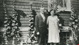
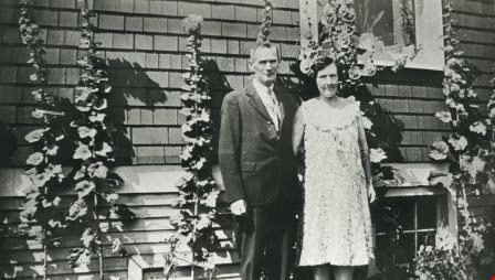
- Scope and Content
- Photograph of Joseph "Joe" Wright and wife Wilhelmina "Mina" Wright (nee Williams) in front of the family home at 3935 Pender Street in Vancouver Heights.
- Repository
- City of Burnaby Archives
- Date
- 1929 (date of original), copied 1986
- Collection/Fonds
- Burnaby Historical Society fonds
- Subseries
- Pioneer Tales subseries
- Physical Description
- 1 photograph : b&w ; 12.7 x 17.8 cm print
- Description Level
- Item
- Record No.
- 204-262
- Access Restriction
- No restrictions
- Reproduction Restriction
- No known restrictions
- Accession Number
- BHS1988-03
- Scope and Content
- Photograph of Joseph "Joe" Wright and wife Wilhelmina "Mina" Wright (nee Williams) in front of the family home at 3935 Pender Street in Vancouver Heights.
- Media Type
- Photograph
- Notes
- Title based on contents of photograph
- Geographic Access
- Pender Street
- Street Address
- 3935 Pender Street
- Historic Neighbourhood
- Vancouver Heights (Historic Neighbourhood)
- Planning Study Area
- Willingdon Heights Area
Images
Kitchener Street School class
https://search.heritageburnaby.ca/link/archivedescription35264
- Repository
- City of Burnaby Archives
- Date
- 1926 (date of original), copied 1986
- Collection/Fonds
- Burnaby Historical Society fonds
- Description Level
- Item
- Physical Description
- 1 photograph : b&w ; 12.7 x 17.8 cm print
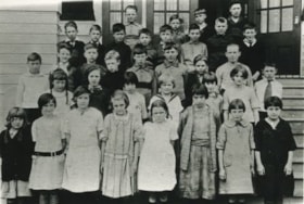
- Scope and Content
- Photograph of Kitchener School class. Keith Hartney is in the fourth row on the far left.
- Repository
- City of Burnaby Archives
- Date
- 1926 (date of original), copied 1986
- Collection/Fonds
- Burnaby Historical Society fonds
- Subseries
- Pioneer Tales subseries
- Physical Description
- 1 photograph : b&w ; 12.7 x 17.8 cm print
- Description Level
- Item
- Record No.
- 204-121
- Access Restriction
- No restrictions
- Reproduction Restriction
- No known restrictions
- Accession Number
- BHS1988-03
- Scope and Content
- Photograph of Kitchener School class. Keith Hartney is in the fourth row on the far left.
- Media Type
- Photograph
- Notes
- Title based on contents of photograph
- Geographic Access
- Gilmore Avenue
- Street Address
- 1351 Gilmore Avenue
- Historic Neighbourhood
- Vancouver Heights (Historic Neighbourhood)
- Planning Study Area
- Willingdon Heights Area
Images

Lane behind the 4400 block of Venables Street
https://search.heritageburnaby.ca/link/archivedescription52833
- Repository
- City of Burnaby Archives
- Date
- 1980
- Collection/Fonds
- Harold H. Johnston fonds
- Description Level
- Item
- Physical Description
- 1 photograph (jpeg) : b&w
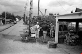
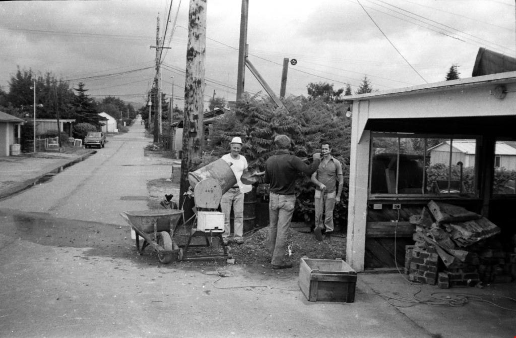
- Scope and Content
- Photograph of three men standing around a cement mixer, preparing cement. The photograph was taken in the lane behind the Johnston family home in the 4400 block of Venables Street.
- Repository
- City of Burnaby Archives
- Date
- 1980
- Collection/Fonds
- Harold H. Johnston fonds
- Physical Description
- 1 photograph (jpeg) : b&w
- Description Level
- Item
- Record No.
- 483-101
- Access Restriction
- No restrictions
- Reproduction Restriction
- No reproduction permitted
- Accession Number
- 2008-08
- Scope and Content
- Photograph of three men standing around a cement mixer, preparing cement. The photograph was taken in the lane behind the Johnston family home in the 4400 block of Venables Street.
- Media Type
- Photograph
- Photographer
- Johnston, Harold H.
- Notes
- Title based on contents of photograph
- Geographic Access
- Venables Street
- Street Address
- 4447 Venables Street
- Historic Neighbourhood
- Vancouver Heights (Historic Neighbourhood)
- Planning Study Area
- Willingdon Heights Area
Images
![Lloyd and Doug Cary on a motorbike, [1929] (date of original), copied 1991 thumbnail](/media/hpo/_Data/_Archives_Images/_Unrestricted/370/370-217.jpg?width=280)
Lloyd and Doug Cary on a motorbike
https://search.heritageburnaby.ca/link/archivedescription37629
- Repository
- City of Burnaby Archives
- Date
- [1929] (date of original), copied 1991
- Collection/Fonds
- Burnaby Historical Society fonds
- Description Level
- Item
- Physical Description
- 1 photograph : b&w ; 3.2 x 5.3 cm print on contact sheet 20.2 x 25.3 cm
- Scope and Content
- Photograph of Lloyd and Doug Cary on an Indian motorbike, on Madison Avenue at the corner of Albert Street (in front of 311 Madison Avenue).
- Repository
- City of Burnaby Archives
- Date
- [1929] (date of original), copied 1991
- Collection/Fonds
- Burnaby Historical Society fonds
- Subseries
- Burnaby Image Bank subseries
- Physical Description
- 1 photograph : b&w ; 3.2 x 5.3 cm print on contact sheet 20.2 x 25.3 cm
- Description Level
- Item
- Record No.
- 370-217
- Access Restriction
- No restrictions
- Reproduction Restriction
- No known restrictions
- Accession Number
- BHS1999-03
- Scope and Content
- Photograph of Lloyd and Doug Cary on an Indian motorbike, on Madison Avenue at the corner of Albert Street (in front of 311 Madison Avenue).
- Subjects
- Transportation - Motorcycles
- Names
- Cary, Doug
- Cary, Lloyd
- Media Type
- Photograph
- Notes
- Title based on contents of photograph
- 1 b&w copy negative accompanying
- Geographic Access
- Madison Avenue
- Street Address
- 311 Madison Avenue
- Historic Neighbourhood
- Vancouver Heights (Historic Neighbourhood)
- Planning Study Area
- Burnaby Heights Area
Images
![Lloyd and Doug Cary on a motorbike, [1929] (date of original), copied 1991 thumbnail](/media/hpo/_Data/_Archives_Images/_Unrestricted/370/370-217.jpg)
![Mary Warren and Bill Anthony, [192-] (date of original), copied 1986 thumbnail](/media/hpo/_Data/_Archives_Images/_Unrestricted/204/204-404.jpg?width=280)
Mary Warren and Bill Anthony
https://search.heritageburnaby.ca/link/archivedescription35546
- Repository
- City of Burnaby Archives
- Date
- [192-] (date of original), copied 1986
- Collection/Fonds
- Burnaby Historical Society fonds
- Description Level
- Item
- Physical Description
- 1 photograph : b&w ; 12.7 x 17.8 cm print
- Scope and Content
- Photograph of Mary Warren and Bill Anthony, west of the Warren family home at 4264 Union Street. The street did not extend past the Warren house. A "corduroy" road was used in the early years: split cedar logs placed side by side.
- Repository
- City of Burnaby Archives
- Date
- [192-] (date of original), copied 1986
- Collection/Fonds
- Burnaby Historical Society fonds
- Subseries
- Pioneer Tales subseries
- Physical Description
- 1 photograph : b&w ; 12.7 x 17.8 cm print
- Description Level
- Item
- Record No.
- 204-404
- Access Restriction
- No restrictions
- Reproduction Restriction
- No known restrictions
- Accession Number
- BHS1988-03
- Scope and Content
- Photograph of Mary Warren and Bill Anthony, west of the Warren family home at 4264 Union Street. The street did not extend past the Warren house. A "corduroy" road was used in the early years: split cedar logs placed side by side.
- Media Type
- Photograph
- Notes
- Title based on contents of photograph
- Geographic Access
- Union Street
- Street Address
- 4264 Union Street
- Historic Neighbourhood
- Vancouver Heights (Historic Neighbourhood)
- Planning Study Area
- Willingdon Heights Area
Images
![Mary Warren and Bill Anthony, [192-] (date of original), copied 1986 thumbnail](/media/hpo/_Data/_Archives_Images/_Unrestricted/204/204-404.jpg)
![Masonic Hall, [1920] (date of original), copied 1986 thumbnail](/media/hpo/_Data/_Archives_Images/_Unrestricted/204/204-289.jpg?width=280)
Masonic Hall
https://search.heritageburnaby.ca/link/archivedescription35431
- Repository
- City of Burnaby Archives
- Date
- [1920] (date of original), copied 1986
- Collection/Fonds
- Burnaby Historical Society fonds
- Description Level
- Item
- Physical Description
- 1 photograph : b&w ; 12.7 x 17.8 cm print
- Scope and Content
- Photograph of 4015 Triumph Street, Vancouver Heights Presbyterian Church at the corner of MacDonald Avenue and Triumph Street, with people playing tennis in the adjoining tennis court. The Hall's basement was used by overcrowded Gilmore School for classes and was also used for first Burnaby North h…
- Repository
- City of Burnaby Archives
- Date
- [1920] (date of original), copied 1986
- Collection/Fonds
- Burnaby Historical Society fonds
- Subseries
- Pioneer Tales subseries
- Physical Description
- 1 photograph : b&w ; 12.7 x 17.8 cm print
- Description Level
- Item
- Record No.
- 204-289
- Access Restriction
- No restrictions
- Reproduction Restriction
- No restrictions
- Accession Number
- BHS1988-03
- Scope and Content
- Photograph of 4015 Triumph Street, Vancouver Heights Presbyterian Church at the corner of MacDonald Avenue and Triumph Street, with people playing tennis in the adjoining tennis court. The Hall's basement was used by overcrowded Gilmore School for classes and was also used for first Burnaby North high school classes before Burnaby North High School was built. It later became the Zenith Masonic Hall.
- Names
- Burnaby North High School
- Gilmore Avenue School
- Masonic Hall
- Vancouver Heights Presbyterian Church
- Media Type
- Photograph
- Photographer
- Eaton, Dr. Carl
- Notes
- Title based on contents of photograph
- Geographic Access
- Triumph Street
- Street Address
- 4015 Triumph Street
- Historic Neighbourhood
- Vancouver Heights (Historic Neighbourhood)
- Planning Study Area
- Burnaby Heights Area
Images
![Masonic Hall, [1920] (date of original), copied 1986 thumbnail](/media/hpo/_Data/_Archives_Images/_Unrestricted/204/204-289.jpg)
![Miss Scott's class at Vancouver Heights Public School, [after 1912] thumbnail](/media/hpo/_Data/_BVM_Images/1985/198900190001.jpg?width=280)
Miss Scott's class at Vancouver Heights Public School
https://search.heritageburnaby.ca/link/museumdescription72
- Repository
- Burnaby Village Museum
- Date
- [after 1912]
- Collection/Fonds
- Burnaby Village Museum Photograph collection
- Description Level
- Item
- Physical Description
- 1 photograph : sepia ; 10 x 15 cm mounted on card 18 x 23 cm
- Scope and Content
- Photograph of Miss Scott's class taken on the steps of Vancouver Heights Public School. The students are standing in seven rows and Miss Scott is standing on the left at the end of the second row.
- Repository
- Burnaby Village Museum
- Collection/Fonds
- Burnaby Village Museum Photograph collection
- Description Level
- Item
- Physical Description
- 1 photograph : sepia ; 10 x 15 cm mounted on card 18 x 23 cm
- Scope and Content
- Photograph of Miss Scott's class taken on the steps of Vancouver Heights Public School. The students are standing in seven rows and Miss Scott is standing on the left at the end of the second row.
- Subjects
- Occupations - Teachers
- Geographic Access
- Gilmore Avenue
- Street Address
- 50 Gilmore Avenue
- Accession Code
- BV989.19.1
- Access Restriction
- No restrictions
- Date
- [after 1912]
- Media Type
- Photograph
- Historic Neighbourhood
- Vancouver Heights (Historic Neighbourhood)
- Planning Study Area
- Burnaby Heights Area
- Scan Resolution
- 600
- Scan Date
- 01-Jun-09
- Scale
- 100
- Photographer
- McConnell, W. F.
- Notes
- Title based on contents of photograph
- Note written in pencil on verso of card mount reads: "R. G. McManus/ 4257 Dundas St [top two lines crossed out]/ North Burnaby B.C" and "c/o Terry Lynn Callender/ TEACHER MISS SCOTT"
- Note written in pen on verso of card mount reads: "AS OF FEB 28/85/ DAVID L. McMANUS/ [address follows]"
- Embossed letters on the card mount reads: "W. F. McConnell/ VANCOUVER, B.C."
Images
![Miss Scott's class at Vancouver Heights Public School, [after 1912] thumbnail](/media/hpo/_Data/_BVM_Images/1985/198900190001.jpg)
![Mr. Porter and Jack Greer, [between 1920 and 1924] (date of original), copied 1991 thumbnail](/media/hpo/_Data/_Archives_Images/_Unrestricted/370/370-143.jpg?width=280)
Mr. Porter and Jack Greer
https://search.heritageburnaby.ca/link/archivedescription37555
- Repository
- City of Burnaby Archives
- Date
- [between 1920 and 1924] (date of original), copied 1991
- Collection/Fonds
- Burnaby Historical Society fonds
- Description Level
- Item
- Physical Description
- 1 photograph : b&w ; 4.1 x 3.0 cm print on contact sheet 20.2 x 25.3 cm
- Scope and Content
- Photograph of (left to right) Mr. Porter and Jack Greer standing in front of a car in front of Mr. Porter's house on the 4200 block of Oxford Street.
- Repository
- City of Burnaby Archives
- Date
- [between 1920 and 1924] (date of original), copied 1991
- Collection/Fonds
- Burnaby Historical Society fonds
- Subseries
- Burnaby Image Bank subseries
- Physical Description
- 1 photograph : b&w ; 4.1 x 3.0 cm print on contact sheet 20.2 x 25.3 cm
- Description Level
- Item
- Record No.
- 370-143
- Access Restriction
- No restrictions
- Reproduction Restriction
- No restrictions
- Accession Number
- BHS1999-03
- Scope and Content
- Photograph of (left to right) Mr. Porter and Jack Greer standing in front of a car in front of Mr. Porter's house on the 4200 block of Oxford Street.
- Subjects
- Transportation - Automobiles
- Names
- Greer, Jack
- Media Type
- Photograph
- Notes
- Title based on contents of photograph
- 1 b&w copy negative accompanying
- Geographic Access
- Oxford Street
- Historic Neighbourhood
- Vancouver Heights (Historic Neighbourhood)
- Planning Study Area
- Burnaby Heights Area
Images
![Mr. Porter and Jack Greer, [between 1920 and 1924] (date of original), copied 1991 thumbnail](/media/hpo/_Data/_Archives_Images/_Unrestricted/370/370-143.jpg)
Mr. Tough and G.L. Lawson beside a tree stump
https://search.heritageburnaby.ca/link/archivedescription38544
- Repository
- City of Burnaby Archives
- Date
- 1921
- Collection/Fonds
- Burnaby Historical Society fonds
- Description Level
- Item
- Physical Description
- 1 photograph : b&w ; 6 x 10.8 cm
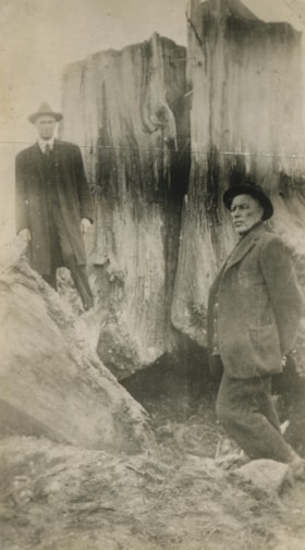
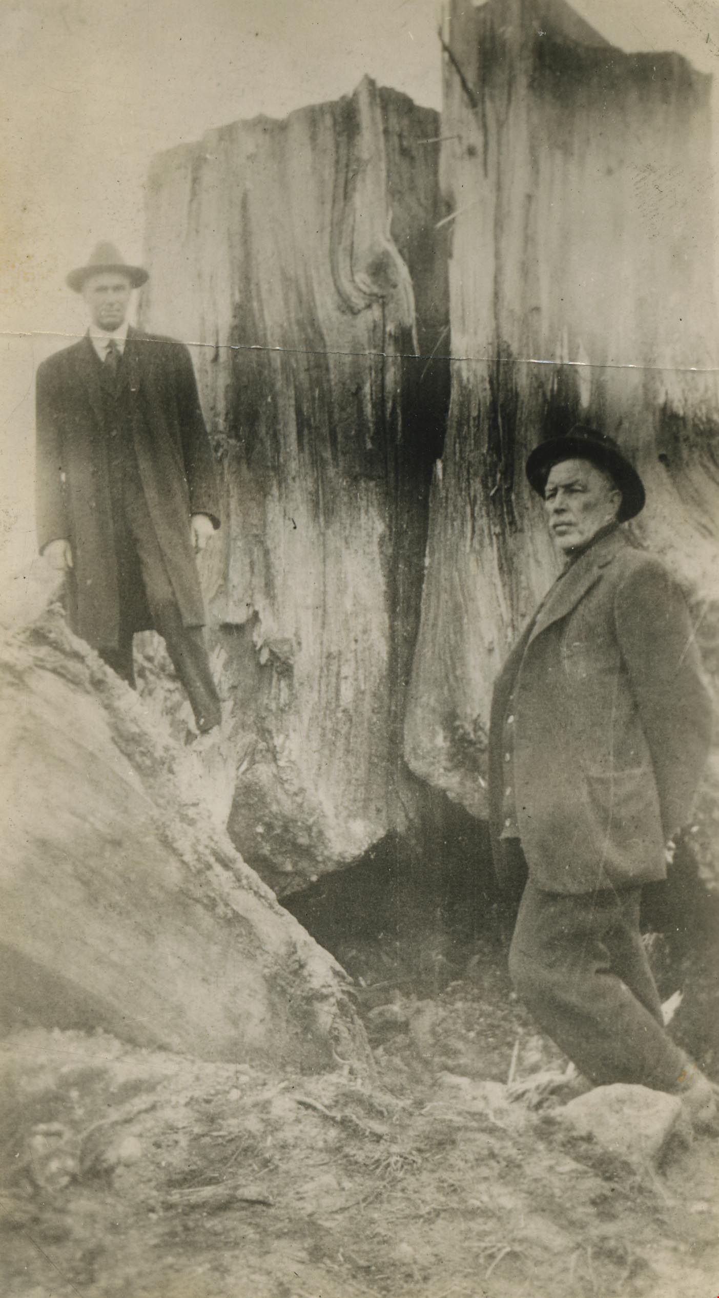
- Scope and Content
- Photograph of two men standing next to a large tree stump. A note written on the back of the photograph reads: " Stump blasted out by William Tough, street sup't [sic] in 1921. It stood on the boulevard on the south side of Hastings Street a few feet East of Ingleton. At left Councillor G. L. La…
- Repository
- City of Burnaby Archives
- Date
- 1921
- Collection/Fonds
- Burnaby Historical Society fonds
- Subseries
- New Westminster Public Library subseries
- Physical Description
- 1 photograph : b&w ; 6 x 10.8 cm
- Description Level
- Item
- Record No.
- 459-004
- Access Restriction
- No restrictions
- Reproduction Restriction
- No known restrictions
- Accession Number
- BHS2003-19
- Scope and Content
- Photograph of two men standing next to a large tree stump. A note written on the back of the photograph reads: " Stump blasted out by William Tough, street sup't [sic] in 1921. It stood on the boulevard on the south side of Hastings Street a few feet East of Ingleton. At left Councillor G. L. Lawson. Right, Mr. Tough." Councillor Lawson served on council from 1919-1920 and again from 1922-1923.
- Media Type
- Photograph
- Notes
- Title based on caption
- Geographic Access
- Hastings Street
- Ingleton Avenue
- Street Address
- 3900 Hastings Street
- Historic Neighbourhood
- Vancouver Heights (Historic Neighbourhood)
- Planning Study Area
- Willingdon Heights Area
Images

Municipality of Burnaby - Volume XV and Volume XVIII
https://search.heritageburnaby.ca/link/museumdescription8680
- Repository
- Burnaby Village Museum
- Date
- May 1927
- Collection/Fonds
- Burnaby Village Museum Map collection
- Description Level
- File
- Physical Description
- 4 plans on 4 sheets : col. lithographic prints ; 63.5 x 53.5 cm folded to 53 x 31.5 cm
- Scope and Content
- File consists of four pages of plans removed from a bound book containing a series of fire insurance plans of the Municipality of Burnaby. The first two pages are numbered "A" and "B" and are key plans from "GREATER VANCOUVER B.C. / VOLUME XV / Surveyed _ May 1927 / MUNICIPALITY OF / BURNABY", "PLA…
- Repository
- Burnaby Village Museum
- Collection/Fonds
- Burnaby Village Museum Map collection
- Description Level
- File
- Physical Description
- 4 plans on 4 sheets : col. lithographic prints ; 63.5 x 53.5 cm folded to 53 x 31.5 cm
- Material Details
- Scales [1:1200] and [1:6000]
- Scope and Content
- File consists of four pages of plans removed from a bound book containing a series of fire insurance plans of the Municipality of Burnaby. The first two pages are numbered "A" and "B" and are key plans from "GREATER VANCOUVER B.C. / VOLUME XV / Surveyed _ May 1927 / MUNICIPALITY OF / BURNABY", "PLAN DEPT. FIRE BRANCH _ B.C. INSURANCE UNDERWRITERS ASSN.". Key Plan "B" covers plans: 1505; 1506; 1512 to 1516; 1540 to 1544; 1550 to 1557 and District Lots: 129 to 132; 135 to 138; 205 to 208 and 215 to 218. Key Plan "A" covers plans: 1501 to 1504; 1507 to 1511; 1517 to 1525; 1531 to 1539; 1545 to 1550 and District Lots: 116 to 127 and 186 to 189. Plan "1806" is part of "GREATER VANCOUVER B.C. / VOLUME XVIII / Municipality of Burnaby / May, 1927" and covers District Lot 153. Plan "1807" is from "GREATER VANCOUVER B.C. / VOLUME XVIII / Municipality of Burnaby / May, 1927" and covers District Lots: 99,149 and 152.
- Responsibility
- British Columbia Underwriters' Association
- Accession Code
- HV972.111.2
- Access Restriction
- No restrictions
- Reproduction Restriction
- May be restricted by third party rights
- Date
- May 1927
- Media Type
- Cartographic Material
- Historic Neighbourhood
- Vancouver Heights (Historic Neighbourhood)
- Lochdale (Historic Neighbourhood)
- Capitol Hill (Historic Neighbourhood)
- Central Park (Historic Neighbourhood)
- Alta Vista (Historic Neighbourhood)
- Planning Study Area
- Burnaby Heights Area
- Sperling-Broadway Area
- Lochdale Area
- Parkcrest-Aubrey Area
- Westridge Area
- Willingdon Heights Area
- Capitol Hill Area
- Maywood Area
- Marlborough Area
- Scan Resolution
- 400
- Scan Date
- 2021-11-18
- Notes
- Title based on content of plans
- Scales are measured 1 inch = 100 feet and 1 inch = 500 feet
- See also BV987.1.70d for revised versions of plans
Zoomable Images


Municipality of Burnaby - Volume XV and Volume XVIII
https://search.heritageburnaby.ca/link/museumdescription8681
- Repository
- Burnaby Village Museum
- Date
- May 1927
- Collection/Fonds
- Burnaby Village Museum Map collection
- Description Level
- File
- Physical Description
- 4 plans on 4 sheets : col. lithographic prints, ms. annotations in blue ink ; 63.5 x 53.5 cm folded to 53 x 31.5 cm
- Scope and Content
- File consists of four pages of plans removed from a bound book containing a series of fire insurance plans of the Municipality of Burnaby. Plan "1507" and plan "1517" are from "GREATER VANCOUVER B.C. / VOLUME XV / Municipality of Burnaby / May, 1927". Plan "1507" covers District Lot 186 and plan "1…
- Repository
- Burnaby Village Museum
- Collection/Fonds
- Burnaby Village Museum Map collection
- Description Level
- File
- Physical Description
- 4 plans on 4 sheets : col. lithographic prints, ms. annotations in blue ink ; 63.5 x 53.5 cm folded to 53 x 31.5 cm
- Material Details
- Scale [1:600] and [1:1200]
- Scope and Content
- File consists of four pages of plans removed from a bound book containing a series of fire insurance plans of the Municipality of Burnaby. Plan "1507" and plan "1517" are from "GREATER VANCOUVER B.C. / VOLUME XV / Municipality of Burnaby / May, 1927". Plan "1507" covers District Lot 186 and plan "1517" covers District Lot 116. Plan "1804" and plan "1805" are from "GREATER VANCOUVER B.C. / VOLUME XVIII / Municipality of Burnaby / May, 1927". Plans "1804" and "1805" cover District Lot 153.
- Responsibility
- British Columbia Underwriters' Association
- Accession Code
- HV972.111.3
- Access Restriction
- No restrictions
- Reproduction Restriction
- May be restricted by third party rights
- Date
- May 1927
- Media Type
- Cartographic Material
- Historic Neighbourhood
- Central Park (Historic Neighbourhood)
- Vancouver Heights (Historic Neighbourhood)
- Planning Study Area
- Maywood Area
- Willingdon Heights Area
- Scan Resolution
- 400
- Scan Date
- 2021-11-18
- Notes
- Title based on content of plans
- See also BV987.1.70d for revised versions of plans
- Scale is measured 1 inch = 100 feet
Images


![Municipality of Burnaby - Volume XV and Volume XVIII, 1927-[1940] thumbnail](/media/hpo/_Data/_BVM_Artifacts/1972/1972_0111_0004_003.jpg?width=280)
Municipality of Burnaby - Volume XV and Volume XVIII
https://search.heritageburnaby.ca/link/museumdescription8682
- Repository
- Burnaby Village Museum
- Date
- 1927-[1940]
- Collection/Fonds
- Burnaby Village Museum Map collection
- Description Level
- File
- Physical Description
- 4 plans on 4 sheets: col. lithographic prints ; 63.5 x 53.5 cm folded to 53 x 31.5 cm
- Scope and Content
- File consists of four pages of plans removed from a bound book containing a series of fire insurance plans of the Municipality of Burnaby. Plan "1518" and "1519" are from "GREATER VANCOUVER B.C. / VOLUME XV / Municipality of Burnaby / May, 1927". Plan "1518" covers District Lot 116 and Plan "1519"…
- Repository
- Burnaby Village Museum
- Collection/Fonds
- Burnaby Village Museum Map collection
- Description Level
- File
- Physical Description
- 4 plans on 4 sheets: col. lithographic prints ; 63.5 x 53.5 cm folded to 53 x 31.5 cm
- Material Details
- Scale [1:600]
- Scope and Content
- File consists of four pages of plans removed from a bound book containing a series of fire insurance plans of the Municipality of Burnaby. Plan "1518" and "1519" are from "GREATER VANCOUVER B.C. / VOLUME XV / Municipality of Burnaby / May, 1927". Plan "1518" covers District Lot 116 and Plan "1519" covers District Lot 121. Plan "1802" and plan "1803" are from "GREATER VANCOUVER B.C. / VOLUME XVIII / Municipality of Burnaby / May, 1927". Both plans "1802" and "1803" cover District Lot 153.
- Responsibility
- British Columbia Underwriters' Association
- Accession Code
- HV972.111.4
- Access Restriction
- No restrictions
- Reproduction Restriction
- May be restricted by third party rights
- Date
- 1927-[1940]
- Media Type
- Cartographic Material
- Historic Neighbourhood
- Vancouver Heights (Historic Neighbourhood)
- Central Park (Historic Neighbourhood)
- Planning Study Area
- Willingdon Heights Area
- Marlborough Area
- Scan Resolution
- 400
- Scan Date
- 2021-11-18
- Notes
- Title based on content of plans
- See also BV987.1.70d for revised versions of plans
- Scale is measured 1 inch = 50 feet
- Contact Burnaby Village Museum to access plans 1518 and 1519 (these plans have revisions on top - date of revisions is uncertain)
Images
![Municipality of Burnaby - Volume XV and Volume XVIII, 1927-[1940] thumbnail](/media/hpo/_Data/_BVM_Artifacts/1972/1972_0111_0004_003.jpg)


Municipality of Burnaby- Volume XV and Volume XVIII
https://search.heritageburnaby.ca/link/museumdescription8686
- Repository
- Burnaby Village Museum
- Date
- May 1927
- Collection/Fonds
- Burnaby Village Museum Map collection
- Description Level
- File
- Physical Description
- 4 plans on 4 sheets : col. lithographic prints ; 63.5 x 53.5 cm folded to 53 x 31.5 cm
- Scope and Content
- File consists of four pages of plans removed from a bound book containing a series of fire insurance plans of the Municipality of Burnaby. Plan "1520" is part of "GREATER VANCOUVER B.C. / VOLUME XV / Municipality of Burnaby / May 1927" and covers District Lots: 121 and 187. Plann "1521" is part of …
- Repository
- Burnaby Village Museum
- Collection/Fonds
- Burnaby Village Museum Map collection
- Description Level
- File
- Physical Description
- 4 plans on 4 sheets : col. lithographic prints ; 63.5 x 53.5 cm folded to 53 x 31.5 cm
- Material Details
- Scale [1:600] and [1:1200]
- Scope and Content
- File consists of four pages of plans removed from a bound book containing a series of fire insurance plans of the Municipality of Burnaby. Plan "1520" is part of "GREATER VANCOUVER B.C. / VOLUME XV / Municipality of Burnaby / May 1927" and covers District Lots: 121 and 187. Plann "1521" is part of "GREATER VANCOUVER B.C. / VOLUME XV / Municipality of Burnaby / May 1927" and covers District Lots: 121 and 187. Key plan "H" reads: "GREATER VANCOUVER B.C. / VOLUME XVIII / Surveyed _ May 1927 / MUNICIPALITY OF / BURNABY" and covers plans: 1813 to 1822; 1824 to 1832; 1839; 1840; 1853 to 1865 and District Lots: 28; 30; 53; 90 to 93; 95 to 97; 155a; 155b; 155c; 159; 160; 171 to 173. Plan "1801" is part of "GREATER VANCOUVER B.C. / VOLUME XVIII / Municipality of Burnaby / May 1927" and covers District Lot 153.
- Responsibility
- British Columbia Underwriters' Association
- Accession Code
- HV972.111.8
- Access Restriction
- No restrictions
- Reproduction Restriction
- May be restricted by third party rights
- Date
- May 1927
- Media Type
- Cartographic Material
- Historic Neighbourhood
- Fraser Arm (Historic Neighbourhood)
- Vancouver Heights (Historic Neighbourhood)
- East Burnaby (Historic Neighbourhood)
- Edmonds (Historic Neighbourhood)
- Planning Study Area
- Marlborough Area
- Kingsway-Beresford Area
- Windsor Area
- Big Bend Area
- Clinton-Glenwood Area
- Burnaby Heights Area
- Edmonds Area
- Stride Avenue Area
- Scan Resolution
- 400
- Scan Date
- 2021-11-18
- Notes
- Title based on content of plans
- See also BV987.1.70d for revised versions of plans
- Scale is measured 1 inch = 500 feet
Zoomable Images


Municipality of Burnaby - Volume XV, Volume XVI, Volume XVII, Volume XVIII
https://search.heritageburnaby.ca/link/museumdescription8685
- Repository
- Burnaby Village Museum
- Date
- May 1927
- Collection/Fonds
- Burnaby Village Museum Map collection
- Description Level
- File
- Physical Description
- 4 plans on 4 sheets : col. lithographic prints ; 63.5 x 53.5 cm folded to 53 x 31.5 cm
- Scope and Content
- File consists of four pages of plans removed from a bound book containing a series of fire insurance plans of the Municipality of Burnaby. Plan "1531" is part of "GREATER VANCOUVER B.C. / VOLUME XV / Municipality of Burnaby / May 1927" and covers District Lots: 116 and 117. Key Plan "C" is part of …
- Repository
- Burnaby Village Museum
- Collection/Fonds
- Burnaby Village Museum Map collection
- Description Level
- File
- Physical Description
- 4 plans on 4 sheets : col. lithographic prints ; 63.5 x 53.5 cm folded to 53 x 31.5 cm
- Material Details
- Scale [1:600] and [1:1200]
- Scope and Content
- File consists of four pages of plans removed from a bound book containing a series of fire insurance plans of the Municipality of Burnaby. Plan "1531" is part of "GREATER VANCOUVER B.C. / VOLUME XV / Municipality of Burnaby / May 1927" and covers District Lots: 116 and 117. Key Plan "C" is part of "GREATER VANCOUVER B.C. / VOLUME XVI / Municipality of Burnaby / May 1927" and covers plans 1623 to 1651 and District Lots: 1 and 2; 4; 6; 8; 10 to 14; 25; 27; 40; 56 to 58; 88 and 89. Plan "1738" is part of "GREATER VANCOUVER B.C. / VOLUME XVII / Municipality of Burnaby / May 1927" and covers District Lots: 34 and 35. Key plan "G" is part of "GREATER VANCOUVER B.C. / VOLUME XVIII / Municipality of Burnaby / May 1927" and covers plans: 1801 to 1813; 1823; 1824; 1833 to 1838; 1841 to 1853 and District Lots: 32; 93; 94; 97 to 99; 149; 150; 152; 155 to 159; 161 to 164.
- Responsibility
- British Columbia Underwriters' Association
- Accession Code
- HV972.111.7
- Access Restriction
- No restrictions
- Reproduction Restriction
- May be restricted by third party rights
- Date
- May 1927
- Media Type
- Cartographic Material
- Historic Neighbourhood
- Central Park (Historic Neighbourhood)
- Fraser Arm (Historic Neighbourhood)
- Alta Vista (Historic Neighbourhood)
- Broadview (Historic Neighbourhood)
- Vancouver Heights (Historic Neighbourhood)
- Burquitlam (Historic Neighbourhood)
- East Burnaby (Historic Neighbourhood)
- Edmonds (Historic Neighbourhood)
- Lozells (Historic Neighbourhood)
- Planning Study Area
- Clinton-Glenwood Area
- Marlborough Area
- Maywood Area
- Windsor Area
- Big Bend Area
- Garden Village Area
- Willingdon Heights Area
- West Central Valley Area
- Cariboo-Armstrong Area
- Lyndhurst Area
- Cameron Area
- Lake City Area
- Edmonds Area
- Second Street Area
- Sperling-Broadway Area
- Lakeview-Mayfield Area
- Scan Resolution
- 400
- Scan Date
- 2021-11-18
- Notes
- Title based on content of plans
- See also BV987.1.70d for revised versions of plans
- Scale is measured 1 inch = 500 feet
Zoomable Images

Municipality of Burnaby - Volume XV, Volume XVI, Volume XVII, Volume XVIII, May 1927
Zoom into Image