Narrow Results By
Subject
- Advertising Medium 2
- Advertising Medium - Flyer 1
- Celebrations 1
- Celebrations - Centennials 1
- Clothing 2
- Clothing - Costumes 2
- Clothing - Outerwear 2
- Documentary Artifacts 6
- Documentary Artifacts - Booklets 1
- Documentary Artifacts - Forms 1
- Documentary Artifacts - Leaflets 1
- Documentary Artifacts - Maps 1
Person / Organization
- British Columbia Ferry Services Incorporated 1
- British Columbia Provincial Police 1
- Burnaby Monumental Works 1
- Burnaby Village Museum 2
- Canada Summer Games 1
- Century Park Museum Association 2
- City of Burnaby 1
- C.W. Parker Company 1
- Girl Guides of Canada 2
- Henderson, Vivian 1
- Hill, Annie Sara Kenrick 2
- Hill, Louis Claude "Claude" 2

Burnaby North High School
https://search.heritageburnaby.ca/link/landmark745
- Repository
- Burnaby Heritage Planning
- Associated Dates
- 1923-1982
- Street View URL
- Google Maps Street View
- Repository
- Burnaby Heritage Planning
- Geographic Access
- Willingdon Avenue
- Associated Dates
- 1923-1982
- Heritage Value
- Burnaby North and Burnaby South were the first high schools built in the City. Before the high school opened, Burnaby students had to travel to Vancouver if they wished to pursue education beyond an elementary level. In 1921, arrangements were made to use the basement of the Presbyterian Church for instruction of local students. By 1922 the Burnaby North High School opened at its first permanent location (4375 Pandora Street - which is now Rosser Elementary). In 1945, the Willingdon Avenue site was built and was used until a new building was constructed in 1961 on Hammarskjold Drive. From 1962, the school was used as Burnaby Heights Junior High school, but it closed in 1982 and the junior high students went to the new Burnaby North on Hammarskjold.
- Historic Neighbourhood
- Capitol Hill (Historic Neighbourhood)
- Planning Study Area
- Capitol Hill Area
- Street Address
- 250 Willingdon Avenue
- Street View URL
- Google Maps Street View
Images


Cariboo Hill Secondary School
https://search.heritageburnaby.ca/link/landmark837
- Repository
- Burnaby Heritage Planning
- Geographic Access
- 16th Avenue
- Associated Dates
- 1961
- Heritage Value
- By 1961, three new elementary schools had been built in the northeast section of Burnaby - Armstrong, Seaforth, and Lyndhurst. With growing enrolment at each, too many students were required to travel a farther distance to attend Edmonds Junior High School. As a result, the Cariboo Hill Secondary School was built in 1961 and opened with 410 students. Its peak enrolment was during the 1974 school year when over 1100 students attended. Additions to the school were made in 1969, 1971 and 1974.
- Historic Neighbourhood
- East Burnaby (Historic Neighbourhood)
- Planning Study Area
- Cariboo-Armstrong Area
- Street Address
- 8580 16th Avenue
- Street View URL
- Google Maps Street View
Images


Fraser River
https://search.heritageburnaby.ca/link/landmark740
- Repository
- Burnaby Heritage Planning
- Repository
- Burnaby Heritage Planning
- Heritage Value
- In peak years, upwards of 100 million salmon would swim up the Fraser River - the largest salmon-bearing river in the world. In August and September sockeye salmon would be pursued by almost 1000 canoes of fishers from all over the coast; people from Sechelt, Nanaimo, Cowichan, Saanich, Lummi Island, Skagit, Snohomish, Sḵwx̱wú7mesh. The estimated peak year sockeye salmon run was 60 million and the estimated yearly consumption by Natives was at least 4 million. In 1808, Simon Fraser became the first known European to travel in the Lower Fraser River.
- Historic Neighbourhood
- Fraser Arm (Historic Neighbourhood)
- Planning Study Area
- Big Bend Area
Images

BCER Burnaby Lake Line
https://search.heritageburnaby.ca/link/landmark760
- Repository
- Burnaby Heritage Planning
- Associated Dates
- 1911
- Heritage Value
- The Burnaby Lake Line was constructed due to the advocacy of Burnaby residents and the Municipality of Burnaby to build the line. A petition was circulated by residents in 1907, and eventually substantial land bonuses were given to the company to induce them to build the line. Property owners in the area hoped the construction of the line would increase their land values. Construction of the 15-mile line was announced in 1909, and the line opened in 1911. The line travelled from Vancouver to New Westminister through central Burnaby.The last day of service was October 23, 1953. When the Trans Canada highway was constructed in the 1960s, it followed the right of way of the Burnaby Lake Line through Burnaby.
- Historic Neighbourhood
- Burnaby Lake (Historic Neighbourhood)
- Planning Study Area
- Burnaby Lake Area
Images


Central Park Tramline
https://search.heritageburnaby.ca/link/landmark732
- Repository
- Burnaby Heritage Planning
- Associated Dates
- 1891
- Heritage Value
- In the 1890s, local entrepreneurs launched electric railways in Vancouver, New Westminster, and Victoria, eager to cash in on the promise of future growth in the major cities of the time. In the Lower Mainland, two companies started building electric rail in 1890: the Westminster and Vancouver Tramway Co., which undertook the ambitious project of building the first real interurban line from New Westminster to Vancouver, and the Westminster Street Railway, who eventually built streetcar service and installed electric lighting in New Westminster. By April 20, 1891, both companies merged to form the Westminster and Vancouver Tramway Company. Local entrepreneurs Henry V. Edmonds, David Oppenheimer, Benjamin Douglas, and Samuel McIntosh, were the directors, all of whom had extensive real estate holdings in the area. Interurban service launched on June 3, 1891, travelling along 12 miles of track from New Westminster to eastern Vancouver, running through Burnaby – which was then an unincorporated area. Installing the single-track line from Vancouver to New Westminster through uneven, forested terrain was a mammoth undertaking. The clearing of the 100-foot right of way and laying the track called for a large work force, some of whom were Chinese "gandy dancers" who had worked on the Canadian Pacific Railway lines. The line was eventually taken over by the B.C. Electric Railway Company in 1897, who remained the owners until the line was finally closed on October 23, 1953 and replaced with the modern bus system. The construction of the SkyTrain along the old route in 1986 reintroduced passenger rail to this historic transportation corridor.
- Historic Neighbourhood
- Central Park (Historic Neighbourhood)
- Planning Study Area
- Maywood Area
Images


Dr. William & Ruth Baldwin House
https://search.heritageburnaby.ca/link/landmark534
- Repository
- Burnaby Heritage Planning
- Description
- The Dr. William & Ruth Baldwin House is a two-storey modern post-and-beam structure, located on the southern shore of Deer Lake in Burnaby's Deer Lake Park. The site is steeply sloped, and the main entrance of the house is at the top of the slope facing onto Deer Lake Drive.
- Associated Dates
- 1965
- Formal Recognition
- Community Heritage Register
- Repository
- Burnaby Heritage Planning
- Geographic Access
- Deer Lake Drive
- Associated Dates
- 1965
- Formal Recognition
- Community Heritage Register
- Enactment Type
- Council Resolution
- Enactment Date
- 26/05/2003
- Description
- The Dr. William & Ruth Baldwin House is a two-storey modern post-and-beam structure, located on the southern shore of Deer Lake in Burnaby's Deer Lake Park. The site is steeply sloped, and the main entrance of the house is at the top of the slope facing onto Deer Lake Drive.
- Heritage Value
- The Baldwin House is valued as a prime example of Burnaby’s post-Second World War modern heritage and progressive architectural style, as well as for its personal connections to internationally-acclaimed architect, Arthur Erickson. Inspired by the modern domestic idiom established earlier in the twentieth century by Frank Lloyd Wright and Richard Neutra, Erickson conceived his architecture as responding directly to the site. A cohesive expression of simple orthogonal lines and ultimate transparency, this structure reduces the idea of post-and-beam West Coast modernism to its most refined elements. A fine example of the evolving talent of Erickson’s earlier work, this house is a landmark modern house in Burnaby and is unique in terms of siting and context. Having just won the 1963 competition for the new Simon Fraser University in Burnaby with his partner, Geoff Massey, and having built fewer than half a dozen homes previously, Erickson’s reputation was growing and his skill as a designer of modern buildings was in great demand. The same year that Erickson/Massey Architects designed SFU, Dr. William Baldwin and his wife, Ruth, personal friends of Erickson, commissioned him to design this house. Erickson was already familiar with the site; as a child he had spent time at this spot when his family visited friends who lived on Deer Lake. Both the Baldwin House and the university were completed in 1965. SFU became internationally famous; the Baldwin House was also considered an architectural success and was recognized in publications of the time. Only a single storey of this two-storey house is visible from the road, as it is built into the hillside in response to its steep site and proximity to Deer Lake. Like many other Erickson designs, this structure was conceived as a pavilion. Constructed of glass and wood, its transparency facilitates visual access to the lake’s edge, acting as an invitation, rather than a barrier, to the landscape. The house blends into the natural surroundings and the site includes other man-made landscape features such as a reflecting pool. As a reaction to the often grey quality of light in the region, Erickson exploits flat planes of water as a source of borrowed light. The refined and purposeful design, transparency, openness of plan and adjacency to the lake combine to give the house a floating appearance at the water's edge. The concept of a floating house set within an accompanying garden was inspired, in part, by the palaces and house boats of Dal Lake in Kashmir and the famed nearby Mughal Gardens. Although Erickson never visited Dal Lake, he travelled extensively throughout India, and specifically mentions the Kashmir reference in relation to this house. There is a rich complexity of other allusions worked into the fabric of the house, unified by a feeling for the conjunction of light, water and land at this special location. Widely renowned as Canada’s most brilliant modern architect, Erickson’s reputation is important to the development and growth of modern architecture in Canada and North America.
- Defining Elements
- The elements of the Baldwin House that define its character are those materials and details which respond to the location of the building and determine the relation between landscape and building, combining to create a single cohesive site. These include its: - close proximity to water - orthogonal plan and massing, with flat tar-and-gravel roof - stepped down massing orienting the house towards the water - post-and-beam construction, with the width of the beams matched to the width of the posts - wood and glass used as primary building materials - transparency and light achieved by the abundant use of glass - large undivided sheets of single glazing - butt glazed glass corners - abundant and generous balconies, which blur the transition from interior to exterior - horizontal flush cedar siding - use of salvaged brick for chimneys - use of chains as downspouts - built-in rooftop barbeque - built in furniture and fittings dating to the time of construction, such as original hardware, benches, bathroom vanities and kitchen cabinets - landscaped site including reflecting pool, plantings and a dock protruding into the lake
- Locality
- Deer Lake Park
- Historic Neighbourhood
- Burnaby Lake (Historic Neighbourhood)
- Planning Study Area
- Morley-Buckingham Area
- Function
- Primary Current--Single Dwelling
- Primary Historic--Single Dwelling
- Community
- Burnaby
- Cadastral Identifier
- P.I.D. No. 011-946-032 and P.I.D. No. 011-946-067
- Boundaries
- The Baldwin House is comprised of two municipally-owned lots located at 6543 and 6545 Deer Lake Drive, Burnaby.
- Area
- 6,070.20
- Contributing Resource
- Building
- Landscape Feature
- Ownership
- Public (local)
- Other Collection
- Canadian Architectural Archives, University of Calgary, Collection: Original Plans No. ERI 4A/76.13
- Documentation
- Heritage Site Files: PC77000 20. City of Burnaby Planning and Building Department, 4949 Canada Way, Burnaby, B.C., V5G 1M2
- Street Address
- 6543 Deer Lake Drive
Images


Joseph & Jane Wintemute House
https://search.heritageburnaby.ca/link/landmark523
- Repository
- Burnaby Heritage Planning
- Description
- The Wintemute House is a large two-storey wood-frame Victorian era country farm house with Victorian Italianate detailing. Designed in a symmetrical Foursquare form, it features a low-pitched hipped roof with deep eaves. Later additions to the rear of the house, and the extensive wraparound veranda…
- Associated Dates
- 1891
- Formal Recognition
- Heritage Designation, Community Heritage Register
- Other Names
- Burnett House
- Street View URL
- Google Maps Street View
- Repository
- Burnaby Heritage Planning
- Other Names
- Burnett House
- Geographic Access
- Berkley Street
- Associated Dates
- 1891
- Formal Recognition
- Heritage Designation, Community Heritage Register
- Enactment Type
- Bylaw No. 6889
- Enactment Date
- 07/03/1977
- Description
- The Wintemute House is a large two-storey wood-frame Victorian era country farm house with Victorian Italianate detailing. Designed in a symmetrical Foursquare form, it features a low-pitched hipped roof with deep eaves. Later additions to the rear of the house, and the extensive wraparound verandah and porte-cochere, were Edwardian era additions. It is located on its original site, in the modern subdivision of Buckingham Heights in southeast Burnaby. The Burnett House is one of the oldest surviving houses in Burnaby.
- Heritage Value
- Built circa 1891, the Joseph and Jane Wintemute House is valued as a representation of the early history of Burnaby and its agricultural origins. Built prior to the civic incorporation of Burnaby in 1892, the house was situated to face Douglas Road (now Canada Way), one of the first roads built to connect the rural farmlands of Burnaby to New Westminster. The original large property has been extensively subdivided and the house is now isolated in a modern subdivision. Designated in 1977, the Wintemute House is also significant as Burnaby's first protected municipal heritage site. The house is valued for its association with Joseph S. Wintemute (1832-1911) and Jane Wintemute (1832-1910), who came to British Columbia from Port Stanley, Ontario in 1865, traveling via the Isthmus of Panama. Joseph Wintemute, a skilled carpenter and contractor by trade, operated the Wintemute Furniture Factory in New Westminster, the first furniture plant established on the mainland of British Columbia. In 1891, he acquired this property, where he set up a cord wood sawmill to supply his factory. Wintemute was likely responsible for the design and construction of this commodious structure, as it was built in an Eastern Canadian style he would have been familiar with. After the lands were cleared of timber, the Wintemutes developed the property into a typical small-scale 'market garden,’ involved in the production of vegetables and fruits, such as strawberries, for sale at the New Westminster City Market. The Wintemute House is additionally significant for its association with the speculative land boom that occurred prior to the First World War, and ongoing suburban subdivision. Charles Gordon, a real estate agent, acquired the Wintemute farm and subdivided the acreage, which he marketed through the People’s Trust Company as 'Montrelynview' and offered this house as a draw prize to lot purchasers. With the collapse of the land boom, the house remained in Gordon’s possession until 1929 when it was purchased by his brother-in-law, Geoffrey Burnett, a local surveyor responsible for many of the original land surveys of Burnaby. David Burnett, Geoffrey's son, requested designation of the house when the family decided to subdivide the remaining 1.4 hectares of property in 1977. Furthermore, the Wintemute House is valued as an excellent example of a Victorian era country farm house, based loosely on the traditional farmhouses seen commonly in nineteenth century Ontario. Designed in a vernacular version of the Victorian Italianate style, the house displays restrained detailing, including several original multi-paned windows notable for their vertical proportions. The house retains many original exterior features, and the original interior layout, although modernized during the Edwardian era, is substantially intact, including finely crafted maple and cedar interior millwork that was produced by the Wintemute Furniture Factory. From 1904 to 1910, Charles Gordon, the second owner, made a number of alterations to the house including the addition of the wrap-around verandah, a porte-cochere and a 7.6 metre by 9 metre billiard room in the Arts and Crafts style, beamed and panelled in Douglas Fir. These later additions and alterations have value in demonstrating the evolution of the house and property and changing tastes at the turn of the nineteenth century.
- Defining Elements
- Key elements that define the heritage character of the Wintemute House include its: - picturesque original setting with views to the North Shore - residential form, scale and massing as expressed by its symmetrical cubic form and two-storey height, with later additions to the rear - Victorian Italianate architectural features such as the vertically-proportioned original windows with vestigial window hoods, low-pitched hipped roof and Classical Revival details such as the corner boards articulated as pilasters - hipped roof with deep boxed eaves - horizontal lapped narrow wooden siding - second storey balcony over front entry - wide wraparound columned verandah with porte-cochere, with square trimmed columns - irregular fenestration: original Victorian era double-hung 6-over-6 wood-sash windows with vertical proportions and segmental arched tops; Edwardian era double-hung 1-over-1 wooden-sash windows; and Edwardian era wooden-sash casement window assemblies with leaded transoms - central front entry with sidelights and transom - multi-paned French doors opening out to verandah - interior features such as its 3.7 metre ceiling height on the main and second floors; the coal grate fireplace with elaborate woodwork and glazed tile surround in the front parlour; five other fireplaces throughout the house; maple and cedar interior millwork; and the Douglas Fir panelled and beamed billiard room with hidden doors, seven-panelled doors, original light fixtures and mouldings - internal red brick chimneys with corbelled caps
- Historic Neighbourhood
- Burnaby Lake (Historic Neighbourhood)
- Planning Study Area
- Morley-Buckingham Area
- Function
- Primary Historic--Single Dwelling
- Primary Current--Single Dwelling
- Community
- Burnaby
- Cadastral Identifier
- 003-297-152
- Boundaries
- The Wintemute House is comprised of a single residential lot located at 7640 Berkley Street, Burnaby.
- Area
- 1566.73
- Contributing Resource
- Building
- Ownership
- Private
- Names
- Wintemute, Joseph
- Street Address
- 7640 Berkley Street
- Street View URL
- Google Maps Street View
Images


Jubilee Grove Arch
https://search.heritageburnaby.ca/link/landmark533
- Repository
- Burnaby Heritage Planning
- Description
- The Jubilee Grove Arch sits at the corner of Kingsway and Patterson Avenue. Located within Central Park, the ceremonial arch and its decorative plantings provide a visual anchor to the northeast corner and entry point to the park.
- Associated Dates
- 1939
- Formal Recognition
- Heritage Designation, Community Heritage Register
- Street View URL
- Google Maps Street View
- Repository
- Burnaby Heritage Planning
- Geographic Access
- Imperial Street
- Associated Dates
- 1939
- Formal Recognition
- Heritage Designation, Community Heritage Register
- Enactment Type
- Bylaw No. 9807
- Enactment Date
- 23/11/1992
- Description
- The Jubilee Grove Arch sits at the corner of Kingsway and Patterson Avenue. Located within Central Park, the ceremonial arch and its decorative plantings provide a visual anchor to the northeast corner and entry point to the park.
- Heritage Value
- Jubilee Grove Arch was dedicated as part of the municipality’s celebration of the Jubilee of the coronation of King George V and was dedicated during Burnaby’s annual May Day celebrations in 1935. Much of the construction work was carried out by local citizens under the direction of the Burnaby Engineering Department through a Depression era work relief program that provided a way for local residents to pay their taxes. The garden was also chosen as the site for the ceremonial planting of an oak tree from the Royal Forest at Windsor, in honor of the Coronation of King George VI and Queen Elizabeth in 1937. The original bronze garden dedication plaque and oak tree remain at the site today. The decorative stone arch was erected in 1939 as a symbol of Burnaby's, and the Lower Mainland of British Columbia’s, strong ties to the English monarchy at the time, and the arch’s unveiling during May Day ceremonies shows the social role that such a commemorative feature played both to the local government and people of Burnaby. It was erected just prior to the Royal Visit of 1939, the first time that reigning British monarchs had travelled to Canada. Built of Haddington Island sandstone, the arch itself was reconstructed from a salvaged architectural element of a historic Vancouver landmark. The arch originally framed the entrance door to the Vancouver Club building in Vancouver, built in 1893-94 on West Hastings Street and designed by architect C.O. Wickenden. The building was demolished in 1930, however the arch was stored and rebuilt as the focal point of the Jubilee Grove after being bought by the Municipality of Burnaby. The work was undertaken by Italian-born stone mason Rizieri Stefanini (1879-1954), the owner of Burnaby Monumental Works. The re-use of the arch symbolizes the close tie between Vancouver and Burnaby and the joint evolution of the neighbouring cities.
- Defining Elements
- The Jubilee Grove Arch has character-defining elements that recognize it both as a remnant of a past building and as a new and individual structure. These include its: - axial diagonal placement and prominent corner location marking one of the entries to Central Park - visibility and accessibility as a public monument - hand carved stone blocks of Haddington Island sandstone - decorative twisted-rope motif carved to outline the arch - supporting rusticated sidewalls with planting urns - original bronze dedication plaque - flanking ornamental gardens - Royal Oak tree and plaque
- Historic Neighbourhood
- Central Park (Historic Neighbourhood)
- Planning Study Area
- Maywood Area
- Organization
- City of Burnaby
- Architect
- C.O. Wickenden
- Function
- Primary Current--Park Fixture
- Primary Historic--Park Fixture
- Community
- Burnaby
- Cadastral Identifier
- P.I.D. No. 017-767-172 Legal Description: Block B of Lot 2 Except Firstly: Part on Plan 8669 and Secondly: Part on Plan LMP4689 District Lot 151, Group 1, New Westminster District, Plan 3443
- Boundaries
- The property (Central Park) is a municipally-owned park that lies at the western edge of Burnaby, between 49th Avenue to the south, Kingsway to the north, Boundary Road to the west and Patterson Avenue to the east.
- Area
- 853,403.82
- Contributing Resource
- Structure
- Landscape Feature
- Ownership
- Public (local)
- Documentation
- Heritage Site Files: PC77000 20. City of Burnaby Planning and Building Department, 4949 Canada Way, Burnaby, B.C., V5G 1M2
- Names
- Burnaby Monumental Works
- Street Address
- 3883 Imperial Street
- Street View URL
- Google Maps Street View
Images


North Road
https://search.heritageburnaby.ca/link/landmark722
- Repository
- Burnaby Heritage Planning
- Associated Dates
- 1859
- Heritage Value
- When New Westminster was chosen as the first site for the capital city of British Columbia in 1859, Colonel R.C. Moody developed a plan to defend the city from American attack by building a road to connect New Westminster to the Burrard Inlet. Although an attack never came, North Road became a well-used route for citizens in the capital city who travelled the road to enjoy a picnic at the beach or to board a ferry for the city of Port Moody. The road's route over the mountain remained in use until the 1960s, when this section was closed to traffic. North Road is the oldest road in the Lower Mainland.
- Planning Study Area
- Burnaby Mountain Area
Images


Parkcrest Neighbourhood
https://search.heritageburnaby.ca/link/landmark671
- Repository
- Burnaby Heritage Planning
- Associated Dates
- 1925-1954
- Heritage Value
- On May 10, 1951, the Burnaby News-Courier reported on the new Parkcrest subdivision, saying: "Central Burnaby is the scenic locale of a successful attempt to produce modern houses economically and yet avoid the mass production effect common to other housing developments. That is one of the many highlights peculiar to the new Parkcrest development of 275 homes...By giving home purchasers a wide choice of finishes, extras and colours, hundreds of variations are possible on the six basic floor plans...Travelling time by car to Hastings and Granville from Parkcrest has been clocked at 15 minutes...Both primary and junior high schools are within walking distance. A modern shopping centre is planned for the future...Several streets are laid out in a straight but irregular manner, thus eliminating the prosaic side by side appearance block by block, as in other housing developments."
- Planning Study Area
- Parkcrest-Aubrey Area
Images

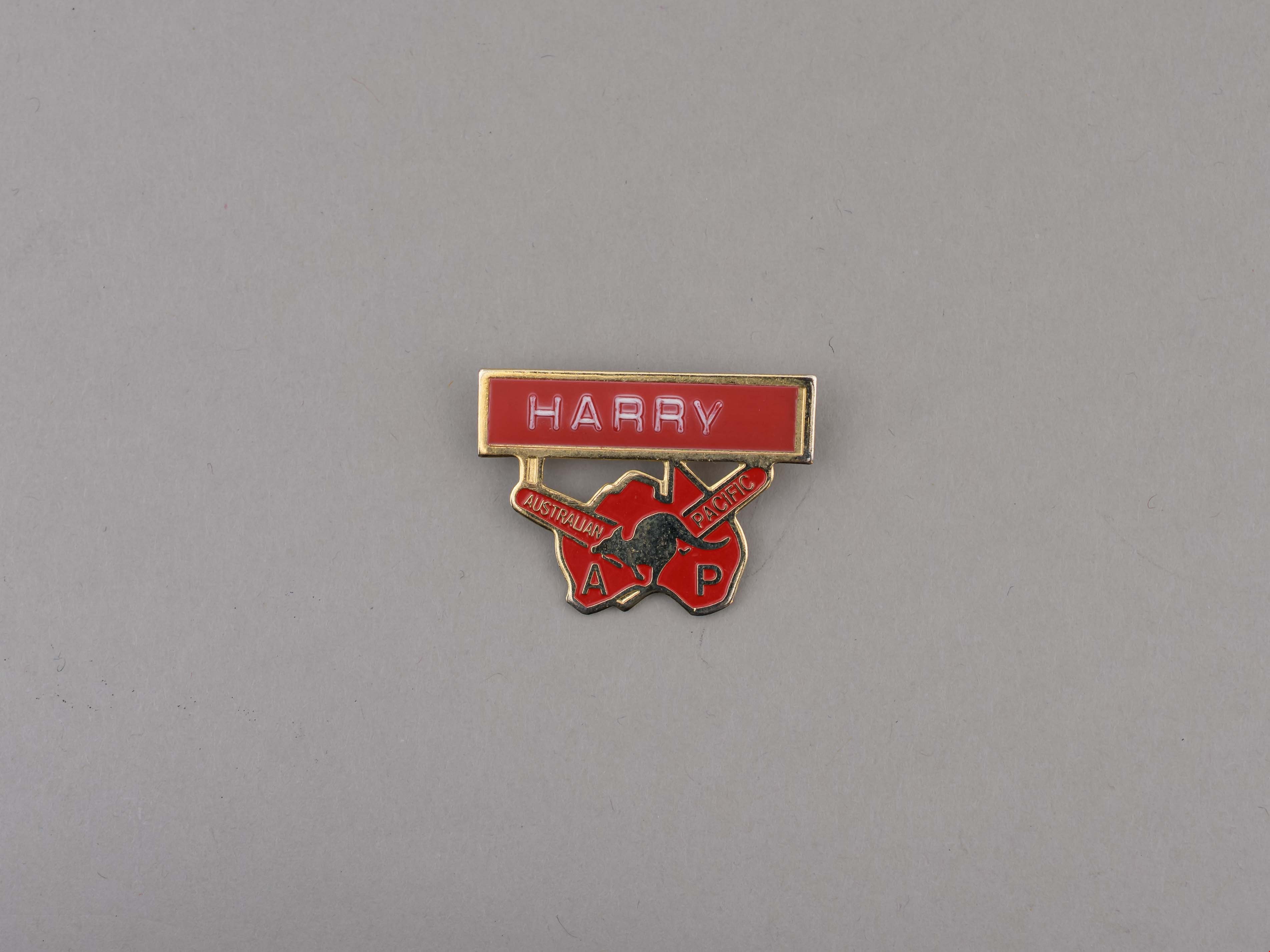
bar pin
https://search.heritageburnaby.ca/link/museumartifact91233
- Repository
- Burnaby Village Museum
- Accession Code
- BV021.23.1
- Description
- Lapel pin name badge from Australian Pacific touring company. The pin is gold coloured with a horizontal bar for a name label to be affixed. Below the bar is the shape of Australia outlined in gold, filled in with red. In the centre is a gold coloured kangaroo witht he company name on either side.
- The name portion has been filled in with a red embossed label with the name "HARRY".
- Object History
- Possible that the pin was made for guests of Australian Pacific tours.
- Category
- 03. Personal Artifacts
- Classification
- Clothing - - Clothing Accessories
- Object Term
- Pin, Bar
- Marks/Labels
- "HARRY"
- "AUSTRALIAN PACIFIC"
- "A P"
- Maker
- Evan Evans
- Subjects
- Travel
Images
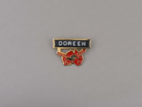
bar pin
https://search.heritageburnaby.ca/link/museumartifact91234
- Repository
- Burnaby Village Museum
- Accession Code
- BV021.23.2
- Description
- Lapel pin name badge from Australian Pacific touring company. The pin is gold coloured with a horizontal bar for a name label to be affixed. Below the bar is the shape of Australia outlined in gold, filled in with red. In the centre is a gold coloured kangaroo witht he company name on either side.
- The name portion has been filled in with a black embossed label with the name "DOREEN".
- Object History
- Possible that the pin was made for guests of Australian Pacific tours.
- Category
- 03. Personal Artifacts
- Classification
- Clothing - - Clothing Accessories
- Object Term
- Pin, Bar
- Marks/Labels
- "HARRY"
- "AUSTRALIAN PACIFIC"
- "A P"
- Maker
- Evan Evans
- Subjects
- Travel
Images

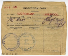
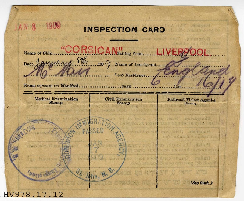
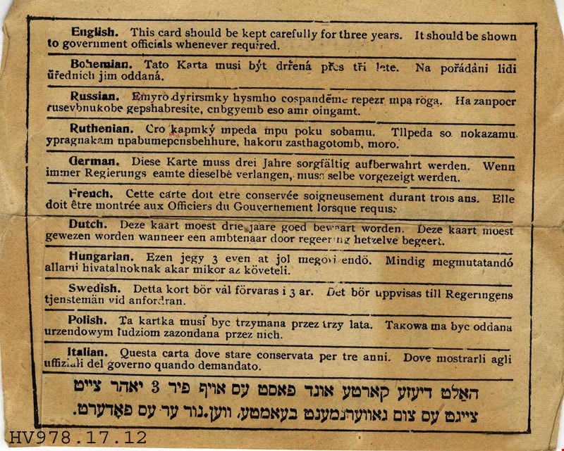
card
https://search.heritageburnaby.ca/link/museumartifact17843
- Repository
- Burnaby Village Museum
- Accession Code
- HV978.17.12
- Description
- Inspection Card - Immigration form -- [1909]. Inspection card for T. McNair when he immigrated to Canada from England in 1909. He sailed on the S.S. Corsican from Liverpool England. The inspection card was started on January 8, 1909. There are two stamps on the form, one for passing the Medical Inspection. The other stamp is from the Dominion Immigration Agency in St. John, New Brunswick stating that McNair passed inspection on January 17th, 1909. The back of the card advises that the card be kept for three years in case it is wanted by the Government. The phrase was translated in to eleven other languages.
- Object History
- Receipt belonging to Thomas Seaborn McNair, who was born on May 15 1888 to Francis McNair and Elizabeth Taylor at sea off New Zealand. He immigrated to Canada in 1909. He worked as an accountant and estate agent. He married Mary Vida McMillan in 1917. Thomas ran Edwards, McNair and Russell in Vancouver (presumably an accounting firm). Thomas McNair died in 1982.
Images
postcard
https://search.heritageburnaby.ca/link/museumartifact38602
- Repository
- Burnaby Village Museum
- Accession Code
- BV997.44.9
- Description
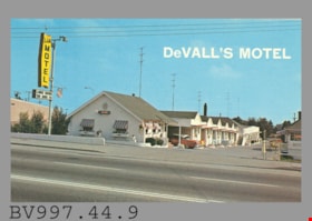
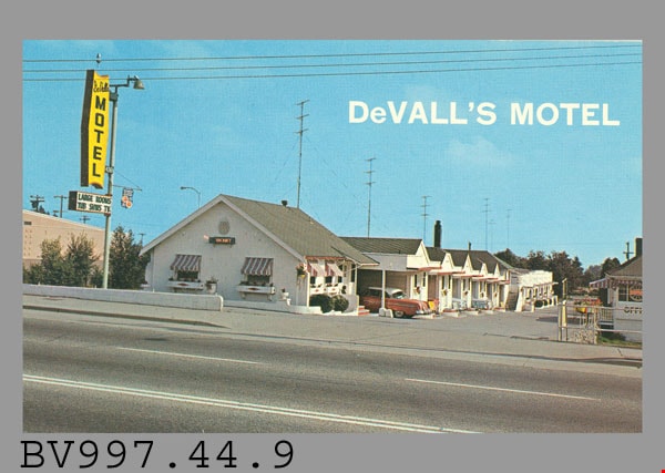
- Postcard: colour photo, glossy; horizontal; row of single-storey white bungalows and drive, office at right front, small neon sign on white wagon wheel in window; large yellow vertical sign at left, black "DeVall's" at top, then "MOTEL" down sign; street address number on lower support; white sign with dark letters arranged as "LARGE ROOMS" "TUB SHWS TV"; smaller CAA and AAA sign at right; taken from across street; on reverse in navy, "OPEN ALL YEAR / PHONE 433-0033" "DeVALL'S MOTEL" "4361 KINGSWAY, BURNABY 1, VANCOUVER, B.C., CANADA" "Steam heated..."; CAA and AAA logos at upper left; up centre, "A Traveltime PRODUCT, MADE IN VANCOUVER, CANADA, BY GRANT-MANN LITHOGRAPHERS LTD."; maple leaf logo at top with "MADE IN CANADA"; at bottom, "C-1294"; at upper right, "POST CARD" "ADDRESS", outline of rectangle for stamp; unused; very slight wear on corners, fraying at right side; the motel was previously known as DeVall's Auto Villas, this image taken from almost the same location as BV002.50.1, but many years later as there have been changes to the buildings, a new sign, and a new building next door
- Classification
- Written Communication T&E - - Writing Media
- Object Term
- Postcard
- Country Made
- Canada
- Province Made
- British Columbia
- Site/City Made
- Vancouver
- Title
- DeVall's Motel C-1294
- Subjects
- Travel
Images
camp blanket
https://search.heritageburnaby.ca/link/museumartifact87411
- Repository
- Burnaby Village Museum
- Accession Code
- BV015.35.42
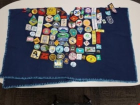
- Description
- camp blanket or poncho; blue fleece “camp” poncho (single piece of cloth with neck hole cut out), hand-done blanket stitching around edges in light blue wool; covered in camp & travel related Guiding patches from the 1970’s & 1980’s (not all are sewn on, some are just pinned) and lapel pins.
- Object History
- Camp blanket that was worn at camp and belonged to Kay Thomas, a longtime Guider from South Burnaby and one of the founding members of the Burnaby Royal Trefoil Guild.
- Category
- 03. Personal Artifacts
- Classification
- Clothing - - Outerwear
- Measurements
- Approx.: 121 cm x 154 cm
- Subjects
- Organizations - Girls' Societies and Clubs
- Organizations - Women's Societies and Clubs
- Recreational Activities - Camping
- Clothing - Outerwear
Images

camp blanket
https://search.heritageburnaby.ca/link/museumartifact87412
- Repository
- Burnaby Village Museum
- Accession Code
- BV015.35.43
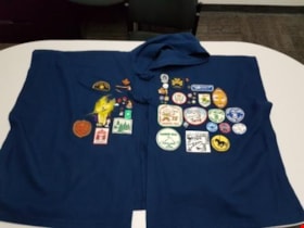
- Description
- camp blanket or cape; blue wool “camp” cape (four pieces sewn together with front opening and hood; two tie fasteners for front opening; snaps to secure side openings); covered in camp & travel related Guiding patches from the 1970’s & 1980’s and some lapel pins.
- Object History
- Camp blanket that was worn at camp and belonged Vivian (Vie) Henderson (1923 - 2007). Mrs. Henderson was the second Burnaby Royal Area Commissioner, from 1974 to 1979. She had previously been a Brown Owl, Guide and Ranger leader, as well as a District and Division Commissioner. She was married to Phil Henderson, noted Burnaby community volunteer.
- Category
- 03. Personal Artifacts
- Classification
- Clothing - - Outerwear
- Measurements
- Approx.: 202 cm (including hood) x 108 cm
- Subjects
- Organizations - Girls' Societies and Clubs
- Recreational Activities - Camping
- Clothing - Outerwear
Images

hatbox
https://search.heritageburnaby.ca/link/museumartifact80214
- Repository
- Burnaby Village Museum
- Accession Code
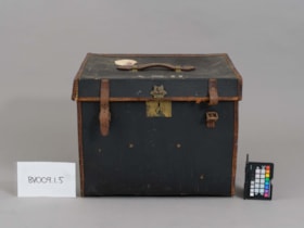
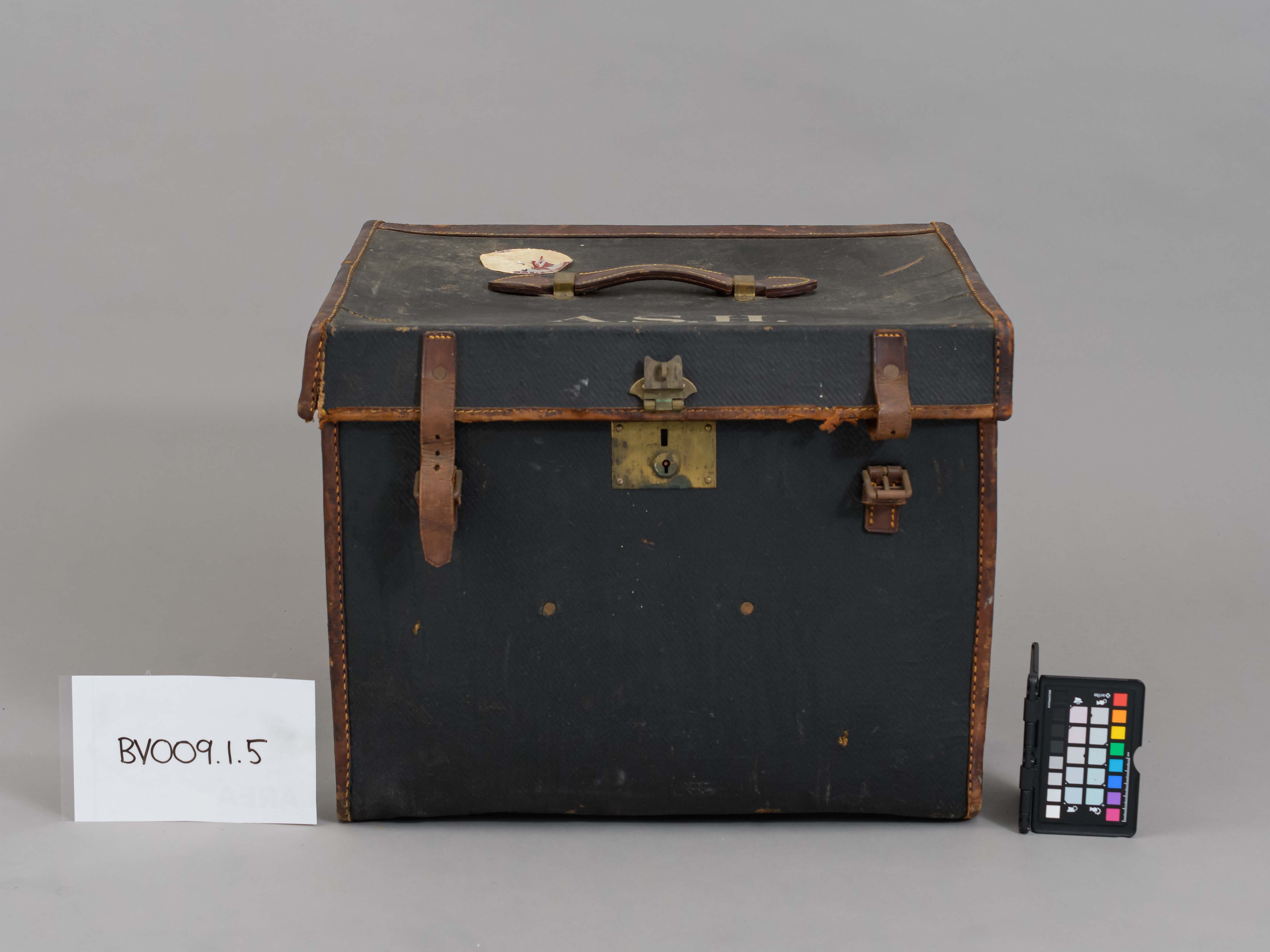
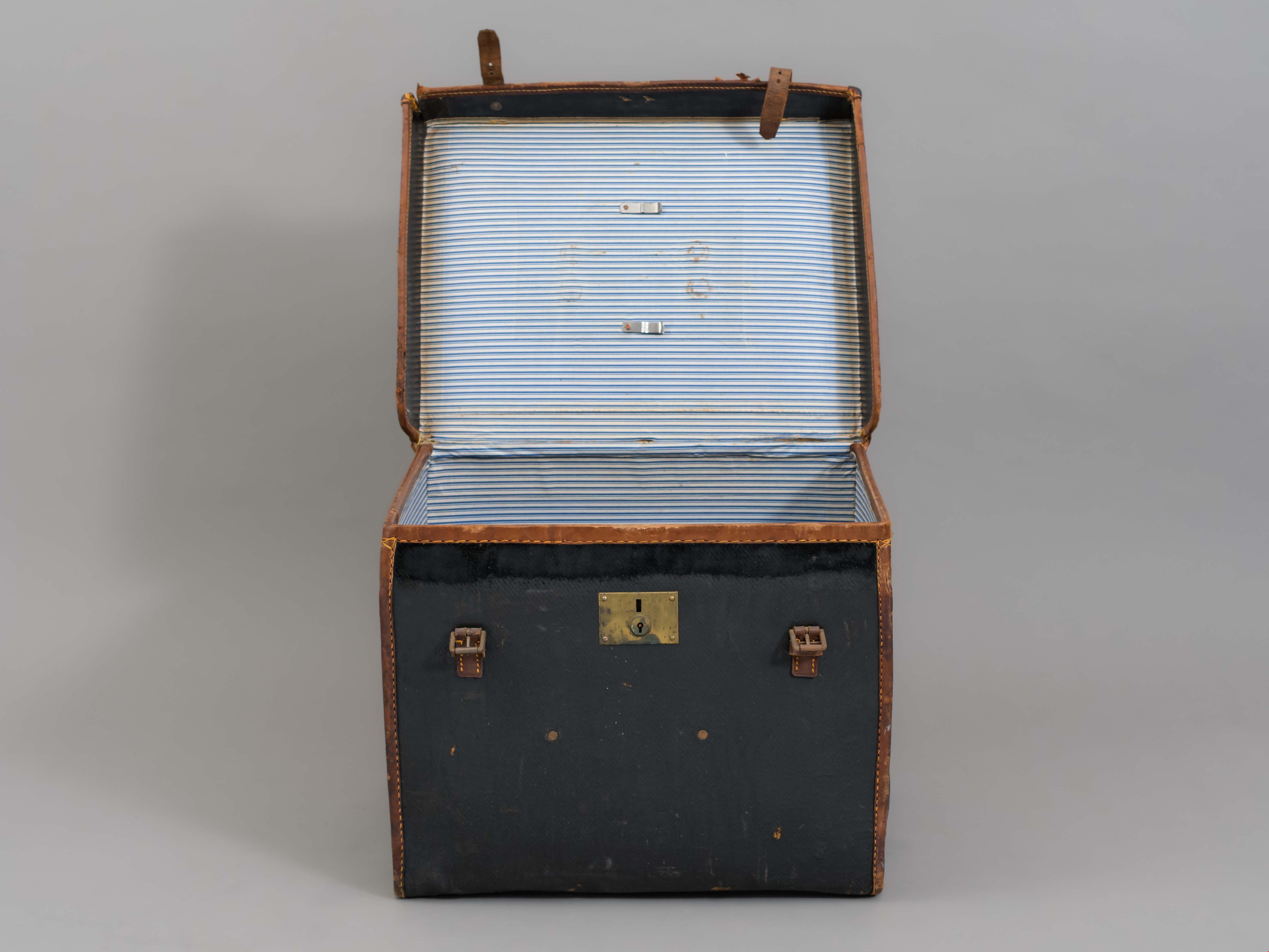
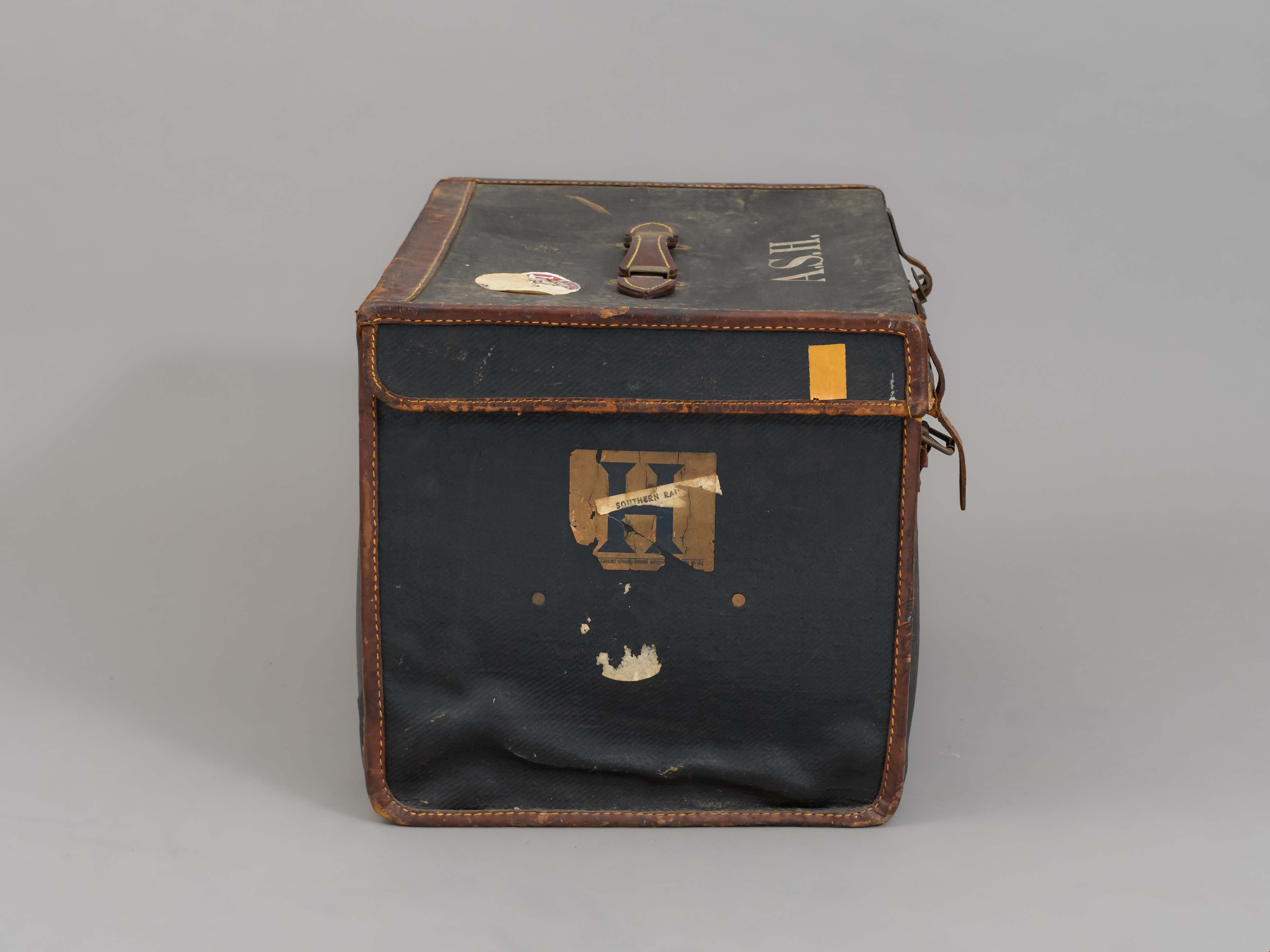
- BV009.1.5
- Description
- Trunk or travelling hatbox for up to six hats. The fiber board trunk is reinforced with leather binding at the seams. It has a carrying handle at the top and two straps and buckles at the front with a hasp at the centre. The lid is hinged at the back. The trunk is black with brown leather binding. The inside is lined with gray and white stripped fabric. The left corner of the lid is torn and the bottom of the trunk has suffered water damage. There are metal clips in each of the sides, bottom and inside of the lid to hold a frame for holding a hat. Up six hats could be accommodated with the hat crowns to the centre of the trunk. "A.S.H." is painted on the top of the trunk and there are travel stickers for "TRANS CANADA / AIR LINES", "ALLAN LINE", steamships and "SOUTHERN RAILWAY", in England. There are the remnants of other stickers on the trunk. Mrs. Hill travelled back and forth to England on several occasions, the last time in 1948 when she flew in her early 90's.
- Object History
- All items are from the L. Claude Hill family and are associated with Anne Sarah Hill (nee Kenrick) and Kitty Hill. Mrs. Hill travelled back and forth to England on several occasions, possibly in 1905 and again possibly in the 1920's. She travelled in 1931 and the last time in 1948 when she flew Trans Canada Airlines (TCA) in her early 90's
- Marks/Labels
- "ASH" is painted on the top of the trunk "TRANS CANADA / AIR LINES", travel sticker pasted on box "ALLAN LINE", travel sticker pasted on box (Allen steamships) "SOUTHERN RAILWAY", travel sticker pasted on box (Southern Railway in England.)
- Measurements
- Measurements: length 51.5 cm X width 40 cm and 40 cm deep all measured on outside.
Images

leaflet
https://search.heritageburnaby.ca/link/museumartifact34876
- Repository
- Burnaby Village Museum
- Accession Code
- BV993.10.7
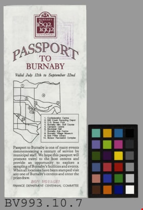
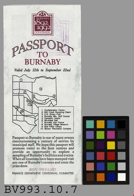
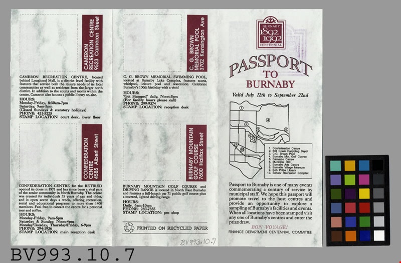
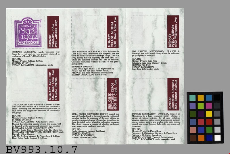
- Description
- Passport to Burnaby - Leaflet -- [1992]. A commemorative leaflet as part of the Burnaby Centennial Celebration. The goal was to promote travel to host centres to receive a stamp as part of a passport. When all stamps were collected the page could be entered into a draw. Participating Host Centres were C.G. Brown Memorial Swimming Pool, Cameron Recreation Centre, Confederation Centre, Burnaby Mountain Golf Course, Burnaby Municipal Hall, Burnaby Village Museum, Bob Prittie Metrotown Branch, The Burnaby Arts Centre, Still Creek Recycling Depot, and Bonsor Recreation Complex. The passport has been stamped for Burnaby Municipal Hall. The leaflet was produced by the Finance Department and the Centennial Committee. The leaflet measures 28cm x 21.5cm.
- Title
- Passport to Burnaby
- Subjects
- Documentary Artifacts
- Documentary Artifacts - Leaflets
- Celebrations
- Celebrations - Centennials
Images
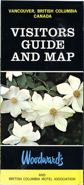
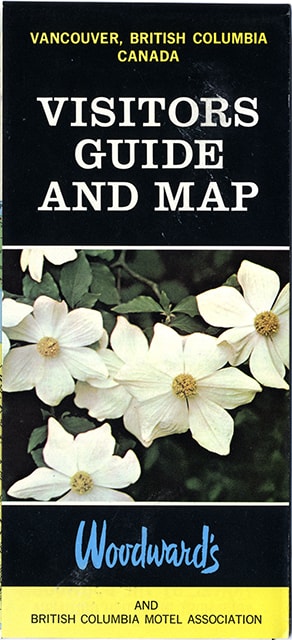
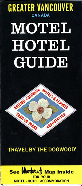
map
https://search.heritageburnaby.ca/link/museumartifact91126
- Repository
- Burnaby Village Museum
- Accession Code
- BV011.44.10
- Description
- map brochure; cover on one side reads "VANCOUVER, BRITISH COLUMBIA / CANADA / VISITORS / GUIDE / AND MAP" and the other side reads: "GREATER VANCOUVER / CANADA / MOTEL / HOTEL / GUIDE / TRAVEL BY THE DOGOOD'" and includes the logo for "British Columbia / Motels & Resorts / Trailer Parks / Association" with dogwood in centre. One side of fold-out includes map titled "Guide Map of Greater Vancouver / Woodwards" and includes inset map of Downtown Vancouver and Stanley Park and inset map of Lower Mainland and Fraser Valley Vancouver and Vicinity along with a list of Greater Vanouver Area Motels and Hotels. The other side of the fold-out includes colour adds for tourist sites and amenities in Greater Vancouver including Capilano Suspension bridge; Heritage Village, Burnaby, B.C.; MacMillan Planetarium; Bloedel Conservatory; Grouse Mountain; Gastown; The Ship of the Seven Seas restaurant and Woodwards stores and shopping centres. Map was published in the public interest by Woodward's (Lower Mainland) department stores; B.C. Motels and Resorts Association Branch "C" whose members appear on the map inside.
- Category
- 08. Communication Artifacts
- Classification
- Documentary Artifacts - - Graphic Documents
- Object Term
- Cartograph, Map
- Measurements
- 45.5 x 70 cm folded to 22.5 x 10 cm
- Country Made
- Canada
- Geographic Access
- Vancouver
Images
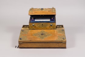
portable desk
https://search.heritageburnaby.ca/link/museumartifact29471
- Repository
- Burnaby Village Museum
- Accession Code
- HV973.56.21
- Description
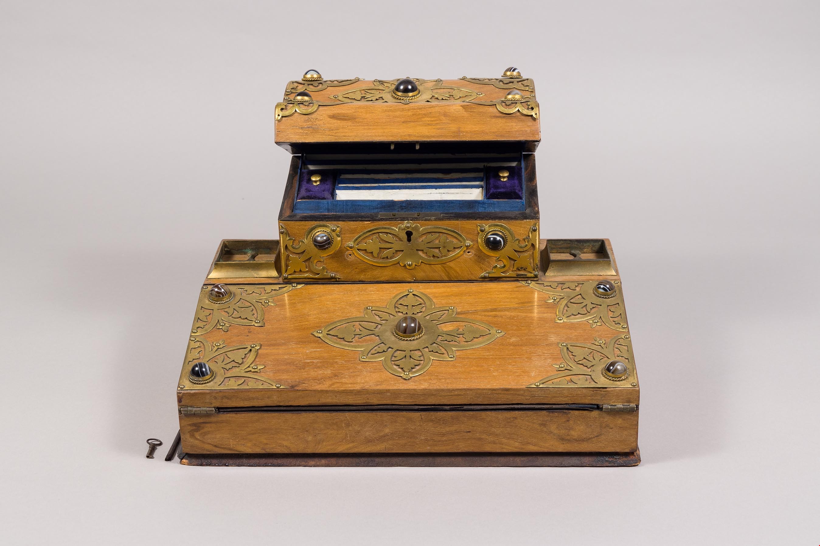
- Walnut chest, lap desk, portable writing cabinet and desk; sides are plain; sloping lid has brass cut-out designs at corners and centre, each with a marble set in the centre; centre design is large petal either side, smaller up and down, with four smallest between; stemmed flower inside larger petals, smallest have leaf; corner designs are one large petal and two half-petals, each with stemmed flower, small flower between petals; brass settings for inkwell, square, one either side of flat part of lid; between these is box with curved lid, plain sides and back, front has brass cut-out designs; at centre, with keyhole, is petal either side, stemmed flower inside; either side is flower in triangle, with marble; lid has similar brass and marble designs to desk lid, but smaller; writing surface of desk is purple fuzzy fabric with border and flourishes; leather-lined compartment under upper part of writing surface, extends under inkwell part with shelves; upper box has vertical compartments, two larger, three smaller, lined with white fabric; pen compartment either side of smaller ones with purple velvet lids and brass knobs; desk and upper box have locks; with key
- Object History
- The donor's family were early settlers to Burnaby, and he worked for the BCER as an electrician. Donor was the original owner of the property that the Burnaby Village Museum now occupies. The writing slope was used widely in the 1800s. It was mainly used in the late 1700s during colonial expeditions, and military travel. It became very popular in Victorian times for lay people and used in many homes. It provided a portable desk, complete with a soft writing surface (felt or leather), compartments for ink, pens, and paper. It was considered to be a personal item, rather than a household one.
- Classification
- Written Communication T&E
- Measurements
- height: 27 cm width: 36 cm depth: 26 cm
Images