Narrow Results By
Subject
- Agricultural Tools and Equipment 1
- Agriculture 1
- Agriculture - Crops 2
- Agriculture - Farms 3
- Animals - Horses 1
- Buildings 1
- Buildings - Civic - Museums 4
- Buildings - Heritage 1
- Buildings - Industrial - Factories 1
- Buildings - Residential - Cabins 1
- Buildings - Schools 17
- Businesses - Blacksmithing 1
Creator
- Adair, Neal G. 3
- Associated Factory Mutual Fire Insurance Cos 1
- Birrell, A. J. 1
- Breed, Charles B. (Charles Blaney), 1875-1958 1
- British Columbia Underwriters' Association 9
- Burnaby Community Heritage Commission 1
- Burnaby, Robert, 1828-1878 1
- Burnaby Village Museum 2
- Burnett and McGugan B.C. Land Surveyors, New Westminster 5
- Burnett, David H. 2
- Burnett, Geoffrey K. 5
- Burnett & McGugan, Engineers and Surveyors 14
Person / Organization
- Armstrong Avenue School 1
- Barnet School 1
- British Columbia Electric Railway Company 1
- Brownlee, James Harrison 1
- Burnaby Historical Society 2
- Burnaby Village Museum 9
- Carter, Earl 1
- Chinese Market Gardens 1
- Dominion Bridge Company 1
- Douglas Road School 1
- Edmonds Community School 2
- Gilmore Avenue School 1
The American library atlas of the world : containing about 100 maps, specially drawn and engraved for this work, from the latest federal, state andtransporation surveys; over 100,000 indexed place names, with their populations, and much valuable statistical information; making a complete compendium of geography with ample text and half-tone illustrations, all fully indexed
https://search.heritageburnaby.ca/link/museumlibrary1718
- Repository
- Burnaby Village Museum
- Author
- Geographical Publishing Co.
- Edition
- New census ed.
- Publication Date
- c1911
- Call Number
- 910 GEO OS
- Repository
- Burnaby Village Museum
- Collection
- Special Collection
- Material Type
- Book
- Accession Code
- HV984.21.31
- Call Number
- 910 GEO OS
- Edition
- New census ed.
- Author
- Geographical Publishing Co.
- Place of Publication
- Chicago
- Publisher
- Geographical
- Publication Date
- c1911
- Physical Description
- 192 p. : ill. (some col.), col. maps ; 38 cm.
- Library Subject (LOC)
- Atlases
- United States--Maps
- Notes
- "Engraved and published by The Geographical Publishing Company"--t.p.

Armstrong Street School site
https://search.heritageburnaby.ca/link/museumdescription11133
- Repository
- Burnaby Village Museum
- Date
- 1915
- Collection/Fonds
- Ronald G. Scobbie collection
- Description Level
- Item
- Physical Description
- 1 survey plan : blueprint on paper ; 56 x 54 cm
- Scope and Content
- Survey plan of "Armstrong Street School Site / Burnaby Municipality" "Being a 2 acre portion of Lot 13 Group 1, & according to map 1722 which shows this as Lot E. Block 2 of subdivision of a portion, of Lot 13, Group 1, New Westminster District".
- Repository
- Burnaby Village Museum
- Collection/Fonds
- Ronald G. Scobbie collection
- Description Level
- Item
- Physical Description
- 1 survey plan : blueprint on paper ; 56 x 54 cm
- Material Details
- Scale 40 feet = 1 inch
- Scope and Content
- Survey plan of "Armstrong Street School Site / Burnaby Municipality" "Being a 2 acre portion of Lot 13 Group 1, & according to map 1722 which shows this as Lot E. Block 2 of subdivision of a portion, of Lot 13, Group 1, New Westminster District".
- Creator
- Burnett, Geoffrey K.
- Subjects
- Buildings - Schools
- Names
- Armstrong Avenue School
- Responsibility
- Burnett & McGugan, Engineers and Surveyors
- Geographic Access
- Armstrong Avenue
- Street Address
- 8757 Armstrong Avenue
- Accession Code
- BV003.83.12
- Access Restriction
- No restrictions
- Reproduction Restriction
- No known restrictions
- Date
- 1915
- Media Type
- Cartographic Material
- Historic Neighbourhood
- East Burnaby (Historic Neighbourhood)
- Planning Study Area
- Cariboo-Armstrong Area
- Scan Resolution
- 440
- Scan Date
- 22-Dec-2020
- Scale
- 100
- Notes
- Title based on contents of plan
- Note in black ink on verso of plan reads: "1746"
- Oath on plan reads: "I, Geoffrey K. Burnett...and did personally superintend the survey represented..." "Completed on the 18th day of March 1915"; signed by Geoffrey K. Burnett and notarized by "K.A. Eastman", sworn "...19th day of April 1915"; "Burnett and McGugan., B.C. Land Surveyors. Etc.. New Westminster, B.C.."
Zoomable Images


Barnet School site
https://search.heritageburnaby.ca/link/museumdescription11140
- Repository
- Burnaby Village Museum
- Date
- May 27, 1915
- Collection/Fonds
- Ronald G. Scobbie collection
- Description Level
- Item
- Physical Description
- 1 survey plan : blueprint on paper ; 56 x 54 cm
- Scope and Content
- Survey plan of "Barnet School Site / Burnaby Municipality" "Being a portion of the west half of lot / 214, Group 1 / New Westminster District”.
- Repository
- Burnaby Village Museum
- Collection/Fonds
- Ronald G. Scobbie collection
- Description Level
- Item
- Physical Description
- 1 survey plan : blueprint on paper ; 56 x 54 cm
- Material Details
- Scale 40 feet = 1 inch
- Scope and Content
- Survey plan of "Barnet School Site / Burnaby Municipality" "Being a portion of the west half of lot / 214, Group 1 / New Westminster District”.
- Creator
- McGugan, Donald Johnston
- Subjects
- Buildings - Schools
- Names
- Barnet School
- Responsibility
- Burnett & McGugan, Engineers and Surveyors
- Geographic Access
- Barnet Road
- Street Address
- 7820 Barnet Road
- Accession Code
- BV003.83.19
- Access Restriction
- No restrictions
- Reproduction Restriction
- No known restrictions
- Date
- May 27, 1915
- Media Type
- Cartographic Material
- Historic Neighbourhood
- Barnet (Historic Neighbourhood)
- Planning Study Area
- Burnaby Mountain Area
- Scan Resolution
- 440
- Scan Date
- 22-Dec-2020
- Scale
- 100
- Notes
- Title based on contents of plan
- handwritten on back "Burnaby Schools" "23R" twice, "1783"
- Oath on plan reads: "I, D.J. McGugan...and did personally superintend the survey..." "completed on the 27th day of May 1915"; signed by D.J. McGugan, notarized by "Walter Edmonds" "sworn "...29th day of May 1915" "Burnett and McGugan" "B.C. Land Surveyors Etc. New Westminster, B.C.";
Zoomable Images


booklet
https://search.heritageburnaby.ca/link/museumartifact19640
- Repository
- Burnaby Village Museum
- Accession Code
- HV977.65.1
- Description
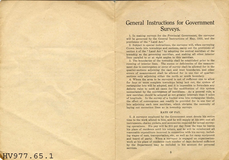
- Government Surveys - Booklet -- [1925]. General instructions for Government Surveys in the Province of British Columbia. The booklet was produced in April 1925, by the Land Department of the Government of British Columbia. The booklet includes information on rate of pay, transportation and accidents.
Images

Burnaby centennial anthology : stories of early Burnaby
https://search.heritageburnaby.ca/link/museumlibrary5472
- Repository
- Burnaby Village Museum
- Edition
- Rev. ed.
- Publication Date
- 1994
- Call Number
- 971.133 BUR COPY 3
- Repository
- Burnaby Village Museum
- Collection
- Digital Reference Collection
- Material Type
- Book
- ISBN
- 0969282826
- Call Number
- 971.133 BUR COPY 3
- Edition
- Rev. ed.
- Place of Publication
- Burnaby, B.C.
- Publisher
- City of Burnaby
- Publication Date
- 1994
- Physical Description
- 531 p. : ill. ; 28 cm.
- Library Subject (LOC)
- Burnaby (B.C.)--History
- Burnaby (B.C.)
- Biography
- Notes
- Includes index.
- 3 copies held: copy 3.
Digital Books

Burnaby Park track
https://search.heritageburnaby.ca/link/museumdescription11918
- Repository
- Burnaby Village Museum
- Date
- June 30, 1932
- Collection/Fonds
- Ronald G. Scobbie collection
- Description Level
- Item
- Physical Description
- 1 survey plan : ink on waxed linen sheet ; 27 x 39 cm
- Scope and Content
- Item consists of a survey plan titled “Burnaby Park Track”.
- Repository
- Burnaby Village Museum
- Collection/Fonds
- Ronald G. Scobbie collection
- Description Level
- Item
- Physical Description
- 1 survey plan : ink on waxed linen sheet ; 27 x 39 cm
- Scope and Content
- Item consists of a survey plan titled “Burnaby Park Track”.
- Accession Code
- BV003.83.41
- Access Restriction
- No restrictions
- Reproduction Restriction
- No known restrictions
- Date
- June 30, 1932
- Media Type
- Cartographic Material
- Notes
- Transcribed title
- Note in pencil reads: ‘4222”
Images


Burnaby property tax assessment ledger no date - pre 1898
https://search.heritageburnaby.ca/link/museumlibrary1118
- Repository
- Burnaby Village Museum
- Collection
- Reference Collection
- Material Type
- Textual Record
- Call Number
- 971.1 BUR
- Author
- J.D.B.
- Place of Publication
- Burnaby
- Publication Date
- 1977
- Physical Description
- 96 p. (typewritten) + title page
- Library Subject (LOC)
- Land titles
- Subjects
- Land - Land Surveying
- Taxes
- Object History
- Compiled July-August 1977, Heritage Village Archives
- Notes
- Unpublished research document: "Burnaby Property Tax Assessment Ledger / No Date --- Pre 1898 / Compiled July-August 1977 / Heritage Village Archives / Original Document No. / Copy #1 / J.D.B./77" -- title page
Images

Documents
Burnaby's heritage : an inventory of buildings and structures
https://search.heritageburnaby.ca/link/museumlibrary5437
- Repository
- Burnaby Village Museum
- Author
- Luxton, Donald, 1954-
- Wolf, Jim
- Edition
- Rev.
- Publication Date
- 2011
- c2007
- Call Number
- 971.133 LUX COPY 1
- Repository
- Burnaby Village Museum
- Collection
- Digital Reference Collection
- Material Type
- Book
- ISBN
- 0969282893
- Call Number
- 971.133 LUX COPY 1
- Edition
- Rev.
- Author
- Luxton, Donald, 1954-
- Wolf, Jim
- Place of Publication
- Burnaby, B.C.
- Publisher
- City of Burnaby
- Publication Date
- 2011
- c2007
- Physical Description
- 157 p. : ill. ; 28 cm.
- Library Subject (LOC)
- Architecture
- Historic buildings
- Buildings
- Historic sites
- Subjects
- Buildings
- Buildings - Heritage
- Notes
- Includes bibliographical references and index.
- 2 copies held: copy 1.
Digital Books
Bygones of Burnaby : an anecdotal history
https://search.heritageburnaby.ca/link/museumlibrary5462
- Repository
- Burnaby Village Museum
- Author
- McGeachie, Pixie, 1921-
- Publication Date
- 1976
- c1975
- Call Number
- 971.133 MCG COPY 4
- Repository
- Burnaby Village Museum
- Collection
- Digital Reference Collection
- Material Type
- Book
- Call Number
- 971.133 MCG COPY 4
- Author
- McGeachie, Pixie, 1921-
- Place of Publication
- Burnaby, B.C.
- Publisher
- Century Park Museum Association
- Publication Date
- 1976
- c1975
- Physical Description
- 108 p. : ill. ; 23 cm.
- Library Subject (LOC)
- Burnaby (B.C.)--History
- Notes
- 4 copies held: copy 4.
Digital Books
Deer Lake Park : heritage resource inventory
https://search.heritageburnaby.ca/link/museumlibrary5468
- Repository
- Burnaby Village Museum
- Author
- Wolf, Jim
- Publication Date
- c1998
- Call Number
- 971.133 WOL COPY 2
- Repository
- Burnaby Village Museum
- Collection
- Reference Collection
- Digital Reference Collection
- Material Type
- Book
- ISBN
- 0969282834
- 9780969282839
- Call Number
- 971.133 WOL COPY 2
- Author
- Wolf, Jim
- Place of Publication
- Burnaby, B.C.
- Publisher
- City of Burnaby, Community Heritage Commission
- Publication Date
- c1998
- Physical Description
- 47 p. : ill. ; 28 cm.
- Library Subject (LOC)
- Deer Lake Park (Burnaby, B.C.)--History
- Historic buildings--British Columbia--Burnaby
- Burnaby (B.C.)--Buildings, structures, etc.
- Notes
- 2 copies held : copy 2.
Digital Books
Dominion Bridge Company Limited - Burnaby Plant
https://search.heritageburnaby.ca/link/museumdescription17538
- Repository
- Burnaby Village Museum
- Date
- 29 Aug. 1957
- Collection/Fonds
- Burnaby Village Museum Map collection
- Description Level
- Item
- Physical Description
- 1 plan : col. lithographic print ; 50.5 x 84 cm
- Scope and Content
- Item consists of a fire insurance plan of the Dominion Bridge Company Burnaby Plant located on the east side of Boundary Road near Lougheed Highway. The plan is in two sheets mounted on a backing board. The buildings are located and colour coded. The plan includes profiles of the buildings. Title o…
- Repository
- Burnaby Village Museum
- Collection/Fonds
- Burnaby Village Museum Map collection
- Description Level
- Item
- Physical Description
- 1 plan : col. lithographic print ; 50.5 x 84 cm
- Material Details
- Scale [1:960]
- Scope and Content
- Item consists of a fire insurance plan of the Dominion Bridge Company Burnaby Plant located on the east side of Boundary Road near Lougheed Highway. The plan is in two sheets mounted on a backing board. The buildings are located and colour coded. The plan includes profiles of the buildings. Title on plan reads "DOMINION BRIDGE COMPANY, LIMITED / "BURNABY PLANT" / Burnaby, B.C.". The site plan was surveyed by C. L. Schwaab Jr.
- History
- Dominion Bridge Company was a major enterprise in Burnaby operating from the 1930 until the mid 1970s. Dominion Bridge constructed steel structures ranging from portions of the Golden Gate and Lions Gate Bridges to holding tanks for pulp mills. Beginning in the mid-1970s, unused areas of the site were used for filming on a temporary basis and in 1987 the site was established as a dedicated studio production facility named Bridge Studios.
- Creator
- Schwabb, C.L. Jr.
- Subjects
- Buildings - Industrial - Factories
- Names
- Dominion Bridge Company
- Responsibility
- Associated Factory Mutual Fire Insurance Cos
- Geographic Access
- Boundary Road
- Street Address
- 2400 Boundary Road
- Accession Code
- BV015.10.1
- Access Restriction
- Restricted access
- Reproduction Restriction
- May be restricted by third party rights
- Date
- 29 Aug. 1957
- Media Type
- Cartographic Material
- Historic Neighbourhood
- Broadview (Historic Neighbourhood)
- Planning Study Area
- West Central Valley Area
- Scan Resolution
- 400
- Scan Date
- 2021-11-28
- Notes
- Title based on contents of plan
- Scale on plan reads "1 inch = 80 ft / By V. Pitkin"
- Identfication information in bottom right corner of plan reads: "FACTORY MUTUAL ENGINEERING DIVISION / Associated Factory Mutual Fire Insurance Cos. / Norwood, Mass. / SERIAl 47330 / Replacing 35238 / INDEX 3994"

Douglas Road School site
https://search.heritageburnaby.ca/link/museumdescription11136
- Repository
- Burnaby Village Museum
- Date
- April 19, 1915
- Collection/Fonds
- Ronald G. Scobbie collection
- Description Level
- Item
- Physical Description
- 1 survey plan : blueprint on paper ; 56 x 54 cm
- Scope and Content
- Survey plan of "Douglas Road School Site / Burnaby Municipality" "Being Lot 21, of Blocks 1-5 inc. 11 & 12 of the subd. of north half of Lot 80, Group 1, New Westminster District".
- Repository
- Burnaby Village Museum
- Collection/Fonds
- Ronald G. Scobbie collection
- Description Level
- Item
- Physical Description
- 1 survey plan : blueprint on paper ; 56 x 54 cm
- Material Details
- Scale 40 feet = 1 inch
- Scope and Content
- Survey plan of "Douglas Road School Site / Burnaby Municipality" "Being Lot 21, of Blocks 1-5 inc. 11 & 12 of the subd. of north half of Lot 80, Group 1, New Westminster District".
- Creator
- McGugan, Donald Johnston
- Subjects
- Buildings - Schools
- Names
- Douglas Road School
- Responsibility
- Burnett & McGugan, Engineers and Surveyors
- Geographic Access
- Canada Way
- Street Address
- 4861 Canada Way
- Accession Code
- BV003.83.15
- Access Restriction
- No restrictions
- Reproduction Restriction
- No known restrictions
- Date
- April 19, 1915
- Media Type
- Cartographic Material
- Historic Neighbourhood
- Burnaby Lake (Historic Neighbourhood)
- Planning Study Area
- Douglas-Gilpin Area
- Scan Resolution
- 440
- Scan Date
- 22-Dec-2020
- Scale
- 100
- Notes
- Title based on contents of plan
- Note in black ink on verso of plan reads: "1747"
- Oath on plan reads: "I, D.G. McGugan..." "...and did person- ally superintend the survey..." "...completed on the 3rd day of April 1915"; signed by D.J. McGugan, notarized by "H.A. Eastman", sworn "...19th day of April 1915" "Burnett and McGugan" "B.C. Land Surveyors Etc. New Westminster, B.C.."
Images


Edmonds Street School site
https://search.heritageburnaby.ca/link/museumdescription11125
- Repository
- Burnaby Village Museum
- Date
- March 8, 1915
- Collection/Fonds
- Ronald G. Scobbie collection
- Description Level
- Item
- Physical Description
- 1 survey plan : blueprint on paper ; 56 x 54 cm
- Scope and Content
- Survey plan of "Edmonds Street School Site" "Burnaby Municipality" "Being Lots 28 and 29 of the Subdivision of Lot 30, Group 1, New Westminster District";
- Repository
- Burnaby Village Museum
- Collection/Fonds
- Ronald G. Scobbie collection
- Description Level
- Item
- Physical Description
- 1 survey plan : blueprint on paper ; 56 x 54 cm
- Material Details
- Scale: 4 feet = 1 inch
- Scope and Content
- Survey plan of "Edmonds Street School Site" "Burnaby Municipality" "Being Lots 28 and 29 of the Subdivision of Lot 30, Group 1, New Westminster District";
- Subjects
- Buildings - Schools
- Names
- Edmonds Community School
- Responsibility
- Burnett and McGugan B.C. Land Surveyors, New Westminster
- Geographic Access
- Edmonds Street
- Street Address
- 7641 Edmonds Street
- Accession Code
- BV003.83.5
- Access Restriction
- No restrictions
- Reproduction Restriction
- No known restrictions
- Date
- March 8, 1915
- Media Type
- Cartographic Material
- Historic Neighbourhood
- Edmonds (Historic Neighbourhood)
- Planning Study Area
- Edmonds Area
- Scan Resolution
- 440
- Scan Date
- 22-Dec-2020
- Scale
- 100
- Notes
- Title based on contents of plan
- Oath in bottom left corner reads: "I, D.J. McGugan...and did personally superintend the survey..." "...completed on the 8th day of March 1915"; signed "D.J. McGugan", notarized by "S.F. Mark" "sworn...12th Day of April 1915"
- handwritten on back, "1756"
Zoomable Images

Excursions in northern British Columbia and Yukon Territory and along the North Pacific Coast : excursions C8 and C9; no.10
https://search.heritageburnaby.ca/link/museumlibrary537
- Repository
- Burnaby Village Museum
- Collection
- Special Collection
- Material Type
- Book
- Accession Code
- BV986.53.45
- Call Number
- 557.1 GSC
- Place of Publication
- Ottawa
- Publisher
- Government Printing Bureau
- Publication Date
- 1913
- Physical Description
- 179 p. : ill., maps (some folded) ; 20 cm.
- Inscription
- Stamped inside: "Kennco Library"
- Library Subject (LOC)
- Geology--British Columbia
- Geology--Yukon
- British Columbia--Description and travel
- Canada, Western--Description and travel
- Yukon--Description and travel
- Notes
- "Excursions C8 and C9."
- Six maps on folded leaves in pocket.
- Includes bibliographies.

Fire insurance key plan - Greater Vancouver - Volume XIX - Municipality of Burnaby
https://search.heritageburnaby.ca/link/museumdescription17799
- Repository
- Burnaby Village Museum
- Date
- 1927
- Collection/Fonds
- Burnaby Village Museum Map collection
- Description Level
- Item
- Physical Description
- 1 plan on 1 sheet : col. lithographic print ; 64 x 54 cm
- Scope and Content
- Item consists of a one page fire insurance key plan titled "Greater Vancouver / Volume XIX / Municipality / of Burnaby / Key Plan" surveyed May 1927. Key plan from compilation, "Insurance Plans of Greater Vancouver Plan No. 11, Volumes 15 to 19 Burnaby".
- Repository
- Burnaby Village Museum
- Collection/Fonds
- Burnaby Village Museum Map collection
- Description Level
- Item
- Physical Description
- 1 plan on 1 sheet : col. lithographic print ; 64 x 54 cm
- Material Details
- Scale [1:6000]
- Scope and Content
- Item consists of a one page fire insurance key plan titled "Greater Vancouver / Volume XIX / Municipality / of Burnaby / Key Plan" surveyed May 1927. Key plan from compilation, "Insurance Plans of Greater Vancouver Plan No. 11, Volumes 15 to 19 Burnaby".
- Publisher
- Plan Department of Fire Branch of British Columbia Underwriters' Association
- Accession Code
- BV987.1.70
- Access Restriction
- No restrictions
- Reproduction Restriction
- May be restricted by third party rights
- Date
- 1927
- Media Type
- Cartographic Material
- Historic Neighbourhood
- Fraser Arm (Historic Neighbourhood)
- Planning Study Area
- Big Bend Area
- Scan Resolution
- 400
- Scan Date
- 2021-11-17
- Notes
- Title based on contents of item
- Scale 500 feet = 1 inch
- These plans were removed from a bound book with labels on cover page reading: "Plan No. 90 / THIS INSURANCE PLAN / of / Vancouver VOLUME "8" / IN THE PROPERTY OF THE / British Columbia Insurance Underwriter's Association / Vancouver B.C. / AND IS LOANED / MELVILLE F. THOMSON CO. .../ Date May 26th, 1934"; / "Plan No. 74 / THIS INSURANCE PLAN / OF / VANCOUVER VOLUME "9"" / Plan No. 11 / THIS INSURANCE PLAN / OF / BURNABY VOLUMES 15-19" / "THIS PLAN IS THE PROPERTY OF / THE / BRITISH LAW INSURANCE COMPANY / LIMITED"
- Does not include the corresponding key plan page or associated plans numbered 1901 to 1914
- Contact Burnaby Village Museum to view associated fire insurance plans
Zoomable Images

Fire insurance key plan - Greater Vancouver - Volume XIX - Municipality of Burnaby, 1927
Zoom into Image
Fire insurance key plan - Greater Vancouver - Volume XVI - Municipality of Burnaby
https://search.heritageburnaby.ca/link/museumdescription17796
- Repository
- Burnaby Village Museum
- Date
- 1927
- Collection/Fonds
- Burnaby Village Museum Map collection
- Description Level
- Item
- Physical Description
- 2 plans on 2 sheets: col. lithographic print ; 64 x 54 cm
- Scope and Content
- Item consists of a two page fire insurance key plan titled "Greater Vancouver / Volume XVI / Municipality / of Burnaby / Key Plan" surveyed May 1927. Volume XVI includes a two page Key Plan (C and D). .
- Repository
- Burnaby Village Museum
- Collection/Fonds
- Burnaby Village Museum Map collection
- Description Level
- Item
- Physical Description
- 2 plans on 2 sheets: col. lithographic print ; 64 x 54 cm
- Scope and Content
- Item consists of a two page fire insurance key plan titled "Greater Vancouver / Volume XVI / Municipality / of Burnaby / Key Plan" surveyed May 1927. Volume XVI includes a two page Key Plan (C and D). .
- Publisher
- Plan Department of Fire Branch of British Columbia Underwriters Association
- Accession Code
- BV987.1.70
- Access Restriction
- No restrictions
- Reproduction Restriction
- May be restricted by third party rights
- Date
- 1927
- Media Type
- Cartographic Material
- Scan Resolution
- 400
- Scan Date
- 11/17/2021
- Notes
- Title based on contents of item
- Item "GREATER VANCOUVER / VOLUME XVI / MUNICIPALITY OF / BURNABY / KEY PLAN" does not include associated numbered plans (1601 to 1651)
- These plans were removed from a bound book with labels on cover page reading: "Plan No. 90 / THIS INSURANCE PLAN / of / Vancouver VOLUME "8" / IN THE PROPERTY OF THE / British Columbia Insurance Underwriter's Association / Vancouver B.C. / AND IS LOANED / MELVILLE F. THOMSON CO. .../ Date May 26th, 1934"; / "Plan No. 74 / THIS INSURANCE PLAN / OF / VANCOUVER VOLUME "9"" / Plan No. 11 / THIS INSURANCE PLAN / OF / BURNABY VOLUMES 15-19" / "THIS PLAN IS THE PROPERTY OF / THE / BRITISH LAW INSURANCE COMPANY / LIMITED"
Zoomable Images

Fire insurance key plan - Greater Vancouver - Volume XVI - Municipality of Burnaby, 1927
Zoom into Image
Fire insurance plans - Greater Vancouver - Volume XVIII - Municipality of Burnaby
https://search.heritageburnaby.ca/link/museumdescription17798
- Repository
- Burnaby Village Museum
- Date
- 1927-1950
- Collection/Fonds
- Burnaby Village Museum Map collection
- Description Level
- Item
- Physical Description
- 22 plans on 12 sheets : col. lithographic print ; 64 x 54 cm
- Scope and Content
- Item consists of fire insurance plans titled "Greater Vancouver / Volume XVIII / Municipality / of Burnaby" surveyed May 1927, revised in October 1940 and September 1950. Includes a two page key plan (G and H) and twenty associated plans numbered; 1801; 1802; 1803; 1804; 1805; 1806; 1807; 1808; 18…
- Repository
- Burnaby Village Museum
- Collection/Fonds
- Burnaby Village Museum Map collection
- Description Level
- Item
- Physical Description
- 22 plans on 12 sheets : col. lithographic print ; 64 x 54 cm
- Material Details
- Scales between [1:600] and [1:6000]
- Scope and Content
- Item consists of fire insurance plans titled "Greater Vancouver / Volume XVIII / Municipality / of Burnaby" surveyed May 1927, revised in October 1940 and September 1950. Includes a two page key plan (G and H) and twenty associated plans numbered; 1801; 1802; 1803; 1804; 1805; 1806; 1807; 1808; 1809; 1810; 1811; 1812; 1813; 1814; 1815; 1819; 1820; 1821; 1822 and 1832.
- Publisher
- Plan Department of Fire Branch of British Columbia Underwriters' Association
- Accession Code
- BV987.1.70
- Access Restriction
- No restrictions
- Reproduction Restriction
- May be restricted by third party rights
- Date
- 1927-1950
- Media Type
- Cartographic Material
- Scan Resolution
- 400
- Scan Date
- 11/17/2021
- Notes
- Title based on contents of item
- Scale 1 inch = 50 feet
- These plans were removed from a bound book with labels on cover page reading: "Plan No. 90 / THIS INSURANCE PLAN / of / Vancouver VOLUME "8" / IN THE PROPERTY OF THE / British Columbia Insurance Underwriter's Association / Vancouver B.C. / AND IS LOANED / MELVILLE F. THOMSON CO. .../ Date May 26th, 1934"; / "Plan No. 74 / THIS INSURANCE PLAN / OF / VANCOUVER VOLUME "9"" / Plan No. 11 / THIS INSURANCE PLAN / OF / BURNABY VOLUMES 15-19" / "THIS PLAN IS THE PROPERTY OF / THE / BRITISH LAW INSURANCE COMPANY / LIMITED"
- Contact Burnaby Village Museum to view associated fire insurance plans
Fire insurance plans - Greater Vancouver - Volume XVII - Municipality of Burnaby
https://search.heritageburnaby.ca/link/museumdescription17797
- Repository
- Burnaby Village Museum
- Date
- 1927-1950
- Collection/Fonds
- Burnaby Village Museum Map collection
- Description Level
- Item
- Physical Description
- 4 plans on 4 sheets : col. lithographic prints
- Scope and Content
- Item consists of fire insurance plans titled "Greater Vancouver / Volume XVII / Municipality / of Burnaby" surveyed May 1927, revised in October 1940 and September 1950. Includes a two page key plan (E and F) and two associated plans numbered 1729 and 1738 (located within District Lot 35).
- Repository
- Burnaby Village Museum
- Collection/Fonds
- Burnaby Village Museum Map collection
- Description Level
- Item
- Physical Description
- 4 plans on 4 sheets : col. lithographic prints
- Scope and Content
- Item consists of fire insurance plans titled "Greater Vancouver / Volume XVII / Municipality / of Burnaby" surveyed May 1927, revised in October 1940 and September 1950. Includes a two page key plan (E and F) and two associated plans numbered 1729 and 1738 (located within District Lot 35).
- Publisher
- Plan Department of Fire Branch of British Columbia Underwriters' Association
- Accession Code
- BV987.1.70
- Access Restriction
- No restrictions
- Reproduction Restriction
- May be restricted by third party rights
- Date
- 1927-1950
- Media Type
- Cartographic Material
- Historic Neighbourhood
- Central Park (Historic Neighbourhood)
- Planning Study Area
- Garden Village Area
- Scan Resolution
- 400
- Scan Date
- 2021-11-17
- Notes
- Title based on contents of item
- These plans were removed from a bound book with labels on cover page reading: "Plan No. 90 / THIS INSURANCE PLAN / of / Vancouver VOLUME "8" / IN THE PROPERTY OF THE / British Columbia Insurance Underwriter's Association / Vancouver B.C. / AND IS LOANED / MELVILLE F. THOMSON CO. .../ Date May 26th, 1934"; / "Plan No. 74 / THIS INSURANCE PLAN / OF / VANCOUVER VOLUME "9"" / Plan No. 11 / THIS INSURANCE PLAN / OF / BURNABY VOLUMES 15-19" / "THIS PLAN IS THE PROPERTY OF / THE / BRITISH LAW INSURANCE COMPANY / LIMITED"
- Contact Burnaby Village Museum to view associated fire insurance plans XVIII
Fire insurance plans - Greater Vancouver - Volume XV - Municipality of Burnaby
https://search.heritageburnaby.ca/link/museumdescription17795
- Repository
- Burnaby Village Museum
- Date
- 1927-1940
- Collection/Fonds
- Burnaby Village Museum Map collection
- Description Level
- Item
- Physical Description
- 11 plans on 8 sheets : col. lithographic print ; 64 x 54 cm
- Scope and Content
- Item consists of fire insurance plans titled "Greater Vancouver / Volume XV / Municipality / of Burnaby" surveyed May 1927 and revised October 1940. Volume XV includes a two page Key Plan (A and B) identifying associated plan numbers and district lots and nine numbered fire insurance plans identifi…
- Repository
- Burnaby Village Museum
- Collection/Fonds
- Burnaby Village Museum Map collection
- Description Level
- Item
- Physical Description
- 11 plans on 8 sheets : col. lithographic print ; 64 x 54 cm
- Material Details
- Scales between [1:600] and [1:6000]
- Scope and Content
- Item consists of fire insurance plans titled "Greater Vancouver / Volume XV / Municipality / of Burnaby" surveyed May 1927 and revised October 1940. Volume XV includes a two page Key Plan (A and B) identifying associated plan numbers and district lots and nine numbered fire insurance plans identified as; 1507; 1508 ; 1517; 1518; 1519; 1520;1521; 1531and 1532.
- Publisher
- Plan Department of Fire Branch of British Columbia Underwriters' Association
- Accession Code
- BV987.1.70
- Access Restriction
- No restrictions
- Reproduction Restriction
- May be restricted by third party rights
- Date
- 1927-1940
- Media Type
- Cartographic Material
- Historic Neighbourhood
- Vancouver Heights (Historic Neighbourhood)
- Planning Study Area
- Burnaby Heights Area
- Willingdon Heights Area
- Scan Resolution
- 400
- Notes
- Title based on contents of item
- These plans are contained within a bound book with labels on cover page reading: "Plan No. 90 / THIS INSURANCE PLAN / of / Vancouver VOLUME "8" / IN THE PROPERTY OF THE / British Columbia Insurance Underwriter's Association / Vancouver B.C. / AND IS LOANED / MELVILLE F. THOMSON CO. .../ Date May 26th, 1934"; / "Plan No. 74 / THIS INSURANCE PLAN / OF / VANCOUVER VOLUME "9"" / Plan No. 11 / THIS INSURANCE PLAN / OF / BURNABY VOLUMES 15-19" / "THIS PLAN IS THE PROPERTY OF / THE / BRITISH LAW INSURANCE COMPANY / LIMITED"
- Fire insurance plans cover various district lots in Burnaby including: District Lot 116,121, 186 and 187.
- Sticker adhered to Key Plan B reads: "
- Contact Burnaby Village Museum to view fire insurance plans that are part of Volume XV

Gilmour Avenue School site
https://search.heritageburnaby.ca/link/museumdescription11129
- Repository
- Burnaby Village Museum
- Date
- May 27, 1915
- Collection/Fonds
- Ronald G. Scobbie collection
- Description Level
- Item
- Physical Description
- 1 survey plan : blueprint on paper ; 56 x 54 cm
- Scope and Content
- Survey plan of Gilmore Avenue School site. Title on plan reads: "Gilmour Avenue School Site / Burnaby Municipality / Being Lots 1-10 inc. & Lots 27-36 inc. of Block 9 / of Subdivision of a Portion of Lot 187, GP.1 / New Westminster District". "Note. School site is as shown below, the original...am…
- Repository
- Burnaby Village Museum
- Collection/Fonds
- Ronald G. Scobbie collection
- Description Level
- Item
- Physical Description
- 1 survey plan : blueprint on paper ; 56 x 54 cm
- Material Details
- Scale: 40 feet = 1 inch
- Scope and Content
- Survey plan of Gilmore Avenue School site. Title on plan reads: "Gilmour Avenue School Site / Burnaby Municipality / Being Lots 1-10 inc. & Lots 27-36 inc. of Block 9 / of Subdivision of a Portion of Lot 187, GP.1 / New Westminster District". "Note. School site is as shown below, the original...amended" "by cancelling Lots 1-10 & 27-30 inc....order of court filed No.4938".
- History
- The school was named after Hugh B. Gilmour, but an error by a municipal clerk in the Street Naming Bylaw in 1912 (Bylaw Number 135) changed the spelling to "Gilmore" Avenue and the school name was spelled "Gilmore" Avenue School hereafter.
- Creator
- McGugan, Donald Johnston
- Subjects
- Buildings - Schools
- Names
- Gilmore Avenue School
- Responsibility
- Burnett & McGugan, Engineers and Surveyors
- Geographic Access
- Gilmore Avenue
- Accession Code
- BV003.83.8
- Access Restriction
- No restrictions
- Reproduction Restriction
- No known restrictions
- Date
- May 27, 1915
- Media Type
- Cartographic Material
- Historic Neighbourhood
- Vancouver Heights (Historic Neighbourhood)
- Planning Study Area
- Willingdon Heights Area
- Scan Resolution
- 440
- Scan Date
- 22-Dec-2020
- Scale
- 100
- Notes
- Transcribed title taken from plan
- Oath in bottom left corner reads: "I, D.J. McGugan...did superintend the survey", "...completed on the 27th day of May 1915" and noterized by Walter Edmonds" "sworn...29th Day of May 1915"; "Burnett and McGugan. B.C. Land Surveyors Etc. New Westminster. B.C."
- Note in black ink on verso of plan reads: "1782"
