Narrow Results By
Subject
- Accidents - Automobile Accidents 1
- Aerial Photographs 1
- Agricultural Tools and Equipment 1
- Agriculture 1
- Agriculture - Crops 2
- Agriculture - Farms 3
- Animals - Horses 1
- Buildings - Civic - Museums 4
- Buildings - Commercial - General Stores 1
- Buildings - Industrial - Refineries 1
- Buildings - Recreational - Sports 1
- Buildings - Residential 2
Creator
- Aero Surveys Limited 1
- Bartel, Mario 10
- Bingham, Alfred "Alf" 1
- British Columbia Underwriters' Association 6
- Burnaby Village Museum 2
- Burnett and McGugan B.C. Land Surveyors, New Westminster 5
- Burnett, David H. 1
- Burnett, Geoffrey K. 4
- Burnett & McGugan, Engineers and Surveyors 11
- Carter, David 1
- Codd, Lisa 1
- Cooke, Rosemary 1
Person / Organization
- A. MacKenzie and Company Jubilee Store 1
- Armstrong Avenue School 1
- Barnet School 1
- Bonsor Recreation Complex 1
- British Columbia Electric Railway Company 1
- Brown, Donald N. "Don" 1
- Brownlee, James Harrison 1
- Burnaby Fire Department 1
- Burnaby Historical Society 1
- Burnaby Mountain Secondary School 1
- Burnaby Village Museum 9
- Carter, Earl 1
![Surveying for the construction of a log cabin, [1976] thumbnail](/media/hpo/_Data/_BVM_Images/2020/2020_0005_0888_001.jpg?width=280)
Surveying for the construction of a log cabin
https://search.heritageburnaby.ca/link/museumdescription13696
- Repository
- Burnaby Village Museum
- Date
- [1976]
- Collection/Fonds
- Century Park Museum Association fonds
- Description Level
- Item
- Physical Description
- 1 photograph : col. slide ; 35 mm
- Scope and Content
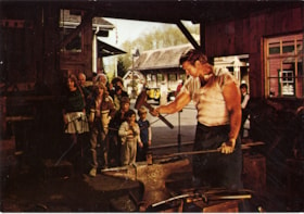
- Photograph of a group of men surveying for the construction of a log cabin. The man in the centre of the photogaph is using a level. In the summer of 1976, Heritage Village Museum offered a two day log cabin building course under the expert instruction of Earl Carter.
- Repository
- Burnaby Village Museum
- Collection/Fonds
- Century Park Museum Association fonds
- Description Level
- Item
- Physical Description
- 1 photograph : col. slide ; 35 mm
- Scope and Content
- Photograph of a group of men surveying for the construction of a log cabin. The man in the centre of the photogaph is using a level. In the summer of 1976, Heritage Village Museum offered a two day log cabin building course under the expert instruction of Earl Carter.
- Accession Code
- BV020.5.888
- Access Restriction
- No restrictions
- Reproduction Restriction
- No known restrictions
- Date
- [1976]
- Media Type
- Photograph
- Scan Resolution
- 2400
- Scan Date
- September 1, 2020
- Scale
- 100
- Notes
- Title based on contents of photograph
- See also BV020.5.709 for documentary film titled "Cabin" directed and produced by James (Jim) Bizzochi - documenting the construction of the log cabin in Heritage Village
Images
![Surveying for the construction of a log cabin, [1976] thumbnail](/media/hpo/_Data/_BVM_Images/2020/2020_0005_0888_001.jpg)

Burnaby property tax assessment ledger no date - pre 1898
https://search.heritageburnaby.ca/link/museumlibrary1118
- Repository
- Burnaby Village Museum
- Collection
- Reference Collection
- Material Type
- Textual Record
- Call Number
- 971.1 BUR
- Author
- J.D.B.
- Place of Publication
- Burnaby
- Publication Date
- 1977
- Physical Description
- 96 p. (typewritten) + title page
- Library Subject (LOC)
- Land titles
- Subjects
- Land - Land Surveying
- Taxes
- Object History
- Compiled July-August 1977, Heritage Village Archives
- Notes
- Unpublished research document: "Burnaby Property Tax Assessment Ledger / No Date --- Pre 1898 / Compiled July-August 1977 / Heritage Village Archives / Original Document No. / Copy #1 / J.D.B./77" -- title page
Images

Documents

Ink
https://search.heritageburnaby.ca/link/museumartifact90812
- Repository
- Burnaby Village Museum
- Accession Code
- BV020.40.3
- Description
- Glass bottle of black ink, with a plastic textured lid. The front label is yellow with a gold border, and a blue band along the bottom of the label. It has a black ink stain down the front. The back label is smaller and lighter colour with a yellow stain that reaches to the middle of the label.
- Object History
- This ink came along with a lettering guide used in the City of Burnaby's Planning Department, in the late 1950s. See also BV020.40.2
- Classification
- Written Communication T&E - - Writing Accessories
- Object Term
- Ink
- Marks/Labels
- Chin-Chin waterproof Liquid PearlInk / Sole Canadian Distributors / Made in Germany / Protect from Freezing
- Colour
- Black
- Yellow
- Blue
- Measurements
- 30cm high
- Maker
- PearlInk
- Subjects
- Documentary Artifacts - Architectural Drawings
- Government - Local Government
- Land - Land Surveying
- Occupations - Civic Workers
- Planning - City Planning
- Historic Neighbourhood
- Burnaby Lake (Historic Neighbourhood)
- Planning Study Area
- Douglas-Gilpin Area
Images

![Interior of surveyor's office, [198_] thumbnail](/media/hpo/_Data/_BVM_Images/2020/2020_0005_0838_002.jpg?width=280)
Interior of surveyor's office
https://search.heritageburnaby.ca/link/museumdescription13495
- Repository
- Burnaby Village Museum
- Date
- [198_]
- Collection/Fonds
- Century Park Museum Association fonds
- Description Level
- Item
- Physical Description
- 1 photograph : col. negative ; 5.5 x 5.5 cm
- Scope and Content
- Photograph of the interior of the Land Surveyor's office "Hill & Burnett" inside of Burnaby Village Museum. The exhibit includes a roll top desk, a pendulum wall clock as well as land surveying equipment.
- Repository
- Burnaby Village Museum
- Collection/Fonds
- Century Park Museum Association fonds
- Description Level
- Item
- Physical Description
- 1 photograph : col. negative ; 5.5 x 5.5 cm
- Scope and Content
- Photograph of the interior of the Land Surveyor's office "Hill & Burnett" inside of Burnaby Village Museum. The exhibit includes a roll top desk, a pendulum wall clock as well as land surveying equipment.
- Subjects
- Occupations - Land Surveyors
- Surveying and Navigational Tools and Equipment
- Timekeeping Tools and Equipment
- Names
- Burnaby Village Museum
- Accession Code
- BV020.5.838
- Access Restriction
- No restrictions
- Reproduction Restriction
- No known restrictions
- Date
- [198_]
- Media Type
- Photograph
- Scan Resolution
- 1200
- Scan Date
- 25-Aug-2020
- Scale
- 100
- Notes
- Title based on contents of photograph
- 1 col. print; 8.5 x 9 cm accompanying negative (negative no.4)
Images
![Interior of surveyor's office, [198_] thumbnail](/media/hpo/_Data/_BVM_Images/2020/2020_0005_0838_002.jpg)

Lettering Guide
https://search.heritageburnaby.ca/link/museumartifact90811
- Repository
- Burnaby Village Museum
- Accession Code
- BV020.40.2
- Description
- Wooden box with a hinged lid and base with slats for rules and holes for lettering tips. The box contains lettering materials, including white rulers,ink pens in green cardboard cylindrical tubes, guiding stencils for lettering in different fonts, metal tool to hold ink nibs.
- Object History
- This lettering guide was used in the City of Burnaby's Planning Department, in the late 1950s. A lettering guide template is a special type of template used to write uniform characters. It consists of a sheet of plastic or other material with cut-outs of letters, numbers, and other shapes used especially for creating technical drawings. For decades they have been essential for lettering a drawing nameplate so text and other designs could be made quickly and uniformly. Although they have been superseded by the use of computers, during the greater part of the last century they were used to relatively ease the lettering process in the creation of technical drawings. They were an indispensable tool for architects and technical illustrators.
- Classification
- Written Communication T&E - - Writing Devices
- Object Term
- Guide, Lettering
- Marks/Labels
- WRICO LETTERING PEN
- Maker
- WRICO
- Subjects
- Construction Tools and Equipment
- Documentary Artifacts - Architectural Drawings
- Government - Local Government
- Land - Land Surveying
- Occupations - Civic Workers
- Historic Neighbourhood
- Burnaby Lake (Historic Neighbourhood)
- Planning Study Area
- Douglas-Gilpin Area
Images


Aliceville
https://search.heritageburnaby.ca/link/landmark721
- Repository
- Burnaby Heritage Planning
- Associated Dates
- 1886
- Heritage Value
- Shortly after the townsite of Port Moody was surveyed in the early 1880s, a resort community developed on the border of Burnaby and Port Moody that would come to be called Aliceville. Located near the north end of North Road, in 1886 the Canadian Pacific Railway established a flag station there and the settlement was named after Alice May Webster who, with her sister Mrs. Jenns, operated the Aliceville Hotel.
- Historic Neighbourhood
- Barnet (Historic Neighbourhood)
- Planning Study Area
- Burnaby Mountain Area
Images


Burnaby Lake Neighbourhood
https://search.heritageburnaby.ca/link/landmark733
- Repository
- Burnaby Heritage Planning
- Repository
- Burnaby Heritage Planning
- Heritage Value
- After New Westminster was established as the Capital City, the surrounding lands were surveyed by the Royal Engineers. The discovery of Burnaby Lake by Robert Burnaby in 1859 soon led to the construction of Douglas Road to Deer Lake in 1861. The completion of the tramline in 1891 renewed interest in the lands around both Burnaby Lake and Deer Lake and soon a group of gentlemen farmers had established strawberry fields and orchards to serve the New Westminster market. These were the most productive and well managed "fruit ranches" in the Fraser Valley. Local strawberries were so admired that they commanded 50 cents more per crate at local markets. One local paper reported that the area appeared as if "an English Village had been taken and planted amidst the grandeur of British Columbia scenery."
- Historic Neighbourhood
- Burnaby Lake (Historic Neighbourhood)
- Planning Study Area
- Douglas-Gilpin Area
Images


Edmonds Neighbourhood
https://search.heritageburnaby.ca/link/landmark704
- Repository
- Burnaby Heritage Planning
- Associated Dates
- 1925-1954
- Heritage Value
- The historic growth of Edmonds as a neighbourhood was based on its strategic location on the early interurban line between Vancouver and New Westminster. Even by 1980 when a survey of the residential neighbourhoods was conducted, a full 25% of homes in the area predated 1930. The 1950s was a period of strong housing development, with both single-family and multi-family units being constructed. Although Burnaby's City Hall was moved from Kingsway and Edmonds in the early 1950s, Edmonds remained an important centre in the community.
- Historic Neighbourhood
- Edmonds (Historic Neighbourhood)
- Planning Study Area
- Stride Avenue Area
Images


Joseph & Jane Wintemute House
https://search.heritageburnaby.ca/link/landmark523
- Repository
- Burnaby Heritage Planning
- Description
- The Wintemute House is a large two-storey wood-frame Victorian era country farm house with Victorian Italianate detailing. Designed in a symmetrical Foursquare form, it features a low-pitched hipped roof with deep eaves. Later additions to the rear of the house, and the extensive wraparound veranda…
- Associated Dates
- 1891
- Formal Recognition
- Heritage Designation, Community Heritage Register
- Other Names
- Burnett House
- Street View URL
- Google Maps Street View
- Repository
- Burnaby Heritage Planning
- Other Names
- Burnett House
- Geographic Access
- Berkley Street
- Associated Dates
- 1891
- Formal Recognition
- Heritage Designation, Community Heritage Register
- Enactment Type
- Bylaw No. 6889
- Enactment Date
- 07/03/1977
- Description
- The Wintemute House is a large two-storey wood-frame Victorian era country farm house with Victorian Italianate detailing. Designed in a symmetrical Foursquare form, it features a low-pitched hipped roof with deep eaves. Later additions to the rear of the house, and the extensive wraparound verandah and porte-cochere, were Edwardian era additions. It is located on its original site, in the modern subdivision of Buckingham Heights in southeast Burnaby. The Burnett House is one of the oldest surviving houses in Burnaby.
- Heritage Value
- Built circa 1891, the Joseph and Jane Wintemute House is valued as a representation of the early history of Burnaby and its agricultural origins. Built prior to the civic incorporation of Burnaby in 1892, the house was situated to face Douglas Road (now Canada Way), one of the first roads built to connect the rural farmlands of Burnaby to New Westminster. The original large property has been extensively subdivided and the house is now isolated in a modern subdivision. Designated in 1977, the Wintemute House is also significant as Burnaby's first protected municipal heritage site. The house is valued for its association with Joseph S. Wintemute (1832-1911) and Jane Wintemute (1832-1910), who came to British Columbia from Port Stanley, Ontario in 1865, traveling via the Isthmus of Panama. Joseph Wintemute, a skilled carpenter and contractor by trade, operated the Wintemute Furniture Factory in New Westminster, the first furniture plant established on the mainland of British Columbia. In 1891, he acquired this property, where he set up a cord wood sawmill to supply his factory. Wintemute was likely responsible for the design and construction of this commodious structure, as it was built in an Eastern Canadian style he would have been familiar with. After the lands were cleared of timber, the Wintemutes developed the property into a typical small-scale 'market garden,’ involved in the production of vegetables and fruits, such as strawberries, for sale at the New Westminster City Market. The Wintemute House is additionally significant for its association with the speculative land boom that occurred prior to the First World War, and ongoing suburban subdivision. Charles Gordon, a real estate agent, acquired the Wintemute farm and subdivided the acreage, which he marketed through the People’s Trust Company as 'Montrelynview' and offered this house as a draw prize to lot purchasers. With the collapse of the land boom, the house remained in Gordon’s possession until 1929 when it was purchased by his brother-in-law, Geoffrey Burnett, a local surveyor responsible for many of the original land surveys of Burnaby. David Burnett, Geoffrey's son, requested designation of the house when the family decided to subdivide the remaining 1.4 hectares of property in 1977. Furthermore, the Wintemute House is valued as an excellent example of a Victorian era country farm house, based loosely on the traditional farmhouses seen commonly in nineteenth century Ontario. Designed in a vernacular version of the Victorian Italianate style, the house displays restrained detailing, including several original multi-paned windows notable for their vertical proportions. The house retains many original exterior features, and the original interior layout, although modernized during the Edwardian era, is substantially intact, including finely crafted maple and cedar interior millwork that was produced by the Wintemute Furniture Factory. From 1904 to 1910, Charles Gordon, the second owner, made a number of alterations to the house including the addition of the wrap-around verandah, a porte-cochere and a 7.6 metre by 9 metre billiard room in the Arts and Crafts style, beamed and panelled in Douglas Fir. These later additions and alterations have value in demonstrating the evolution of the house and property and changing tastes at the turn of the nineteenth century.
- Defining Elements
- Key elements that define the heritage character of the Wintemute House include its: - picturesque original setting with views to the North Shore - residential form, scale and massing as expressed by its symmetrical cubic form and two-storey height, with later additions to the rear - Victorian Italianate architectural features such as the vertically-proportioned original windows with vestigial window hoods, low-pitched hipped roof and Classical Revival details such as the corner boards articulated as pilasters - hipped roof with deep boxed eaves - horizontal lapped narrow wooden siding - second storey balcony over front entry - wide wraparound columned verandah with porte-cochere, with square trimmed columns - irregular fenestration: original Victorian era double-hung 6-over-6 wood-sash windows with vertical proportions and segmental arched tops; Edwardian era double-hung 1-over-1 wooden-sash windows; and Edwardian era wooden-sash casement window assemblies with leaded transoms - central front entry with sidelights and transom - multi-paned French doors opening out to verandah - interior features such as its 3.7 metre ceiling height on the main and second floors; the coal grate fireplace with elaborate woodwork and glazed tile surround in the front parlour; five other fireplaces throughout the house; maple and cedar interior millwork; and the Douglas Fir panelled and beamed billiard room with hidden doors, seven-panelled doors, original light fixtures and mouldings - internal red brick chimneys with corbelled caps
- Historic Neighbourhood
- Burnaby Lake (Historic Neighbourhood)
- Planning Study Area
- Morley-Buckingham Area
- Function
- Primary Historic--Single Dwelling
- Primary Current--Single Dwelling
- Community
- Burnaby
- Cadastral Identifier
- 003-297-152
- Boundaries
- The Wintemute House is comprised of a single residential lot located at 7640 Berkley Street, Burnaby.
- Area
- 1566.73
- Contributing Resource
- Building
- Ownership
- Private
- Names
- Wintemute, Joseph
- Street Address
- 7640 Berkley Street
- Street View URL
- Google Maps Street View
Images


Pioneer tales of Burnaby
https://search.heritageburnaby.ca/link/museumlibrary5860
- Repository
- Burnaby Village Museum
- Collection
- Digital Reference Collection
- Reference Collection
- Material Type
- Book
- ISBN
- 096928280x
- Call Number
- 971.133 SON COPY 4
- Contributor
- Sone, Michael
- Place of Publication
- Burnaby, B.C.
- Publisher
- Corporation of the District of Burnaby
- Publication Date
- c1987
- Physical Description
- 495 p. : ill. ; 31 cm.
- Inscription
- "TR687 - Bryburgh" / handprinted in pencil on frontend page
- Library Subject (LOC)
- Pioneers--British Columbia--Burnaby
- Frontier and pioneer life
- Biography
- Object History
- Early Burnaby as recalled by the settlers themselves who arrived from every corner of the world between 1888 and 1930, some witnessing incorporation of the district in 1892, all seeking a better life for themselves and especially for their children, all helping transform the wilderness into the modern municipality of today.
- Notes
- "Editor Michael Sone".
- Includes index.
- 4 copies held: copy 4
Images

Digital Books
Heritage Village Museum blacksmith shop postcard
https://search.heritageburnaby.ca/link/museumdescription15413
- Repository
- Burnaby Village Museum
- Date
- Dec. 1984
- Collection/Fonds
- Donald Copan collection
- Description Level
- Item
- Physical Description
- 1 photograph : col. postcard ; 10.5 x 15 cm
- Scope and Content
- Photographic postcard with photograph of a blacksmith working in the blacksmith shop inside of Heritage Village Museum (now Burnaby Village Museum) while a group of visitors look on. The postcard is from Heritage Village Museum and is addressed to "D & B Copan..." with an invitation for "Surveying …
- Repository
- Burnaby Village Museum
- Collection/Fonds
- Donald Copan collection
- Series
- B.C. Summer Games series
- Description Level
- Item
- Physical Description
- 1 photograph : col. postcard ; 10.5 x 15 cm
- Scope and Content
- Photographic postcard with photograph of a blacksmith working in the blacksmith shop inside of Heritage Village Museum (now Burnaby Village Museum) while a group of visitors look on. The postcard is from Heritage Village Museum and is addressed to "D & B Copan..." with an invitation for "Surveying Weekend September 29 & 30 / Come to the Museum on Saturday or Sunday to see demonstratons of early surveying equipment, lectures, and interesting personalities from this field..."
- Names
- Burnaby Village Museum
- Accession Code
- BV021.4.23
- Access Restriction
- No restrictions
- Reproduction Restriction
- No known restrictions
- Date
- Dec. 1984
- Media Type
- Photograph
- Scan Resolution
- 600
- Scan Date
- April 1, 2021
- Scale
- 100
- Notes
- Title based on contents of photograph
Images


History of Burnaby Resource Guide
https://search.heritageburnaby.ca/link/museumlibrary7492
- Repository
- Burnaby Village Museum
- Author
- Burnaby Village Museum
- Publication Date
- 2019
of land, and become the “owners” of
that land by clearing trees and building homes.
Dispossession meant taking control of land and resources forcibly
from Indigenous people. The Royal Engineers assisted this process as
a military presence, and by surveying and building wagon roads and
town sites that
- Repository
- Burnaby Village Museum
- Collection
- Digital Reference Collection
- Material Type
- Digital Resource
- Accession Code
- BV019.63.1
- Author
- Burnaby Village Museum
- Place of Publication
- Burnaby, BC
- Publisher
- City of Burnaby
- Publication Date
- 2019
- Physical Description
- 21 p. : ill.
- Library Subject (LOC)
- Burnaby (B.C.)--History
- Directories
- Object History
- Created from research gathered by Burnaby Village Museum staff into the diverse History of Burnaby.
Images

Digital Books
![A. MacKenzie and Company Jubilee Store, [1912] thumbnail](/media/hpo/_Data/_Archives_Images/_Unrestricted/205/228-005.jpg?width=280)
A. MacKenzie and Company Jubilee Store
https://search.heritageburnaby.ca/link/archivedescription36144
- Repository
- City of Burnaby Archives
- Date
- [1912]
- Collection/Fonds
- Burnaby Historical Society fonds
- Description Level
- Item
- Physical Description
- 1 photograph : sepia ; 11.5 x 16.5 cm
- Scope and Content
- Photograph of the exterior side view of A. MacKenzie & Co / Jubilee Store. There are two men in suits standing beside a wagon, one with his hands on his hips, surveying a pile of bundles of wood that look like they have just fallen from the wagoon into the snow. A child stands at the front door of…
- Repository
- City of Burnaby Archives
- Date
- [1912]
- Collection/Fonds
- Burnaby Historical Society fonds
- Physical Description
- 1 photograph : sepia ; 11.5 x 16.5 cm
- Description Level
- Item
- Record No.
- 228-005
- Access Restriction
- No restrictions
- Reproduction Restriction
- No known restrictions
- Accession Number
- BHS1989-22
- Scope and Content
- Photograph of the exterior side view of A. MacKenzie & Co / Jubilee Store. There are two men in suits standing beside a wagon, one with his hands on his hips, surveying a pile of bundles of wood that look like they have just fallen from the wagoon into the snow. A child stands at the front door of the shop, also looking at the bundles. The store was owned by Alexander MacKenzie, (1870-1949) who arrived in Vancouver in 1907. This store later became the Matheson and Sons Market.
- Media Type
- Photograph
- Notes
- Title based on contents of photograph
- Geographic Access
- Kingsway
- Nelson Avenue
- Historic Neighbourhood
- Central Park (Historic Neighbourhood)
Images
![A. MacKenzie and Company Jubilee Store, [1912] thumbnail](/media/hpo/_Data/_Archives_Images/_Unrestricted/205/228-005.jpg)
![Collision Plus Exclusive Auto Body fire, [2004] thumbnail](/media/hpo/_Data/_Archives_Images/_Unrestricted/535/535-1740.jpg?width=280)
Collision Plus Exclusive Auto Body fire
https://search.heritageburnaby.ca/link/archivedescription95989
- Repository
- City of Burnaby Archives
- Date
- [2004]
- Collection/Fonds
- Burnaby NewsLeader photograph collection
- Description Level
- Item
- Physical Description
- 1 photograph (tiff) : col.
- Scope and Content
- Photograph of Captain Mark Fletcher of the Burnaby Fire Department outside of the burned-out garage at the Collision Plus Exclusive Auto Body. An employee of the auto shop stands next to Fletcher and they are surveying the damage.
- Repository
- City of Burnaby Archives
- Date
- [2004]
- Collection/Fonds
- Burnaby NewsLeader photograph collection
- Physical Description
- 1 photograph (tiff) : col.
- Description Level
- Item
- Record No.
- 535-1740
- Access Restriction
- No restrictions
- Reproduction Restriction
- No restrictions
- Accession Number
- 2018-12
- Scope and Content
- Photograph of Captain Mark Fletcher of the Burnaby Fire Department outside of the burned-out garage at the Collision Plus Exclusive Auto Body. An employee of the auto shop stands next to Fletcher and they are surveying the damage.
- Names
- Burnaby Fire Department
- Media Type
- Photograph
- Photographer
- Bartel, Mario
- Notes
- Title based on caption
- Collected by editorial for use in a January 2004 issue of the Burnaby NewsLeader
- Caption from metadata: "Captain Mark Fletcher, of the Burnaby Fire Department, and Mickey Reale, the manager at Collision Plus Auto Body on Edmonds St., survey the damage after an early morning fire destroyed three cars in the shop garage."
- Geographic Access
- Edmonds Street
Images
![Collision Plus Exclusive Auto Body fire, [2004] thumbnail](/media/hpo/_Data/_Archives_Images/_Unrestricted/535/535-1740.jpg)

Gilmore Avenue and Douglas Road
https://search.heritageburnaby.ca/link/archivedescription34112
- Repository
- City of Burnaby Archives
- Date
- March 27, 1947
- Collection/Fonds
- Burnaby Historical Society fonds
- Description Level
- Item
- Physical Description
- 1 photograph : b&w negative ; 6.8 x 11.6 cm
- Scope and Content
- Photograph of Gilmore Avenue and Douglas Road with a car parked at the side of the road and two men with surveying equipment. This is part of the Willingdon Heights subdivision site.
- Repository
- City of Burnaby Archives
- Date
- March 27, 1947
- Collection/Fonds
- Burnaby Historical Society fonds
- Subseries
- Alfred Bingham subseries
- Physical Description
- 1 photograph : b&w negative ; 6.8 x 11.6 cm
- Description Level
- Item
- Record No.
- 010-028
- Access Restriction
- No restrictions
- Reproduction Restriction
- No known restrictions
- Accession Number
- BHS2007-04
- Scope and Content
- Photograph of Gilmore Avenue and Douglas Road with a car parked at the side of the road and two men with surveying equipment. This is part of the Willingdon Heights subdivision site.
- Subjects
- Industries - Construction
- Buildings - Residential - Houses
- Construction Tools and Equipment
- Media Type
- Photograph
- Photographer
- Bingham, Alfred "Alf"
- Notes
- Title based on contents of photograph
- Geographic Access
- Gilmore Avenue
- Douglas Road
Images

![Inside of the surveyor's office, [198_] thumbnail](/media/hpo/_Data/_BVM_Images/2020/2020_0005_0665_001.jpg?width=280)
Inside of the surveyor's office
https://search.heritageburnaby.ca/link/museumdescription13035
- Repository
- Burnaby Village Museum
- Date
- [198_]
- Collection/Fonds
- Century Park Museum Association fonds
- Description Level
- Item
- Physical Description
- 1 photograph : col. ; 20 x 25 cm
- Scope and Content
- Photograph of the interior of the "Surveyor's Office" inside of the Heritage Village Museum. A long wood table, wood stove, roll top desk, survey plans and surveying equipment are visible.
- Repository
- Burnaby Village Museum
- Collection/Fonds
- Century Park Museum Association fonds
- Description Level
- Item
- Physical Description
- 1 photograph : col. ; 20 x 25 cm
- Scope and Content
- Photograph of the interior of the "Surveyor's Office" inside of the Heritage Village Museum. A long wood table, wood stove, roll top desk, survey plans and surveying equipment are visible.
- Names
- Burnaby Village Museum
- Accession Code
- BV020.5.665
- Access Restriction
- No restrictions
- Reproduction Restriction
- No known restrictions
- Date
- [198_]
- Media Type
- Photograph
- Related Material
- See also photograph BV020.5.664
- Scan Resolution
- 600
- Scan Date
- 1-May-20
- Scale
- 100
- Notes
- Title based on contents of photograph
Images
![Inside of the surveyor's office, [198_] thumbnail](/media/hpo/_Data/_BVM_Images/2020/2020_0005_0665_001.jpg)

Interior of land surveyor's office at Burnaby Village Museum
https://search.heritageburnaby.ca/link/museumdescription13768
- Repository
- Burnaby Village Museum
- Date
- Sept. 1987
- Collection/Fonds
- Century Park Museum Association fonds
- Description Level
- Item
- Physical Description
- 1 photograph : col. ; 9 x 12.5 cm
- Scope and Content
- Photograph of the interior of the land surveyor's office at Burnaby Village Museum. Office is furnished with a roll top desk, maps and plans and various surveying tools.
- Repository
- Burnaby Village Museum
- Collection/Fonds
- Century Park Museum Association fonds
- Description Level
- Item
- Physical Description
- 1 photograph : col. ; 9 x 12.5 cm
- Scope and Content
- Photograph of the interior of the land surveyor's office at Burnaby Village Museum. Office is furnished with a roll top desk, maps and plans and various surveying tools.
- Names
- Burnaby Village Museum
- Geographic Access
- Deer Lake Avenue
- Accession Code
- BV020.5.958
- Access Restriction
- No restrictions
- Reproduction Restriction
- No known restrictions
- Date
- Sept. 1987
- Media Type
- Photograph
- Scan Resolution
- 600
- Scan Date
- 22-Sep-2020
- Scale
- 100
- Notes
- Title based on contents of photograph
Images

![Land surveyor on a road, [1999] thumbnail](/media/hpo/_Data/_Archives_Images/_Unrestricted/535/535-3313.jpg?width=280)
Land surveyor on a road
https://search.heritageburnaby.ca/link/archivedescription98246
- Repository
- City of Burnaby Archives
- Date
- [1999]
- Collection/Fonds
- Burnaby NewsLeader photograph collection
- Description Level
- Item
- Physical Description
- 1 photograph (tiff) : b&w
- Scope and Content
- Photograph of an unidentified land surveyor standing behind a land surveying total station at the curve of a road.
- Repository
- City of Burnaby Archives
- Date
- [1999]
- Collection/Fonds
- Burnaby NewsLeader photograph collection
- Physical Description
- 1 photograph (tiff) : b&w
- Description Level
- Item
- Record No.
- 535-3313
- Access Restriction
- No restrictions
- Reproduction Restriction
- No restrictions
- Accession Number
- 2018-12
- Scope and Content
- Photograph of an unidentified land surveyor standing behind a land surveying total station at the curve of a road.
- Media Type
- Photograph
- Notes
- Title based on contents of photograph
- Collected by editorial for use in a September 1999 issue of the Burnaby NewsLeader
Images
![Land surveyor on a road, [1999] thumbnail](/media/hpo/_Data/_Archives_Images/_Unrestricted/535/535-3313.jpg)
Lillian Mann's property
https://search.heritageburnaby.ca/link/archivedescription46229
- Repository
- City of Burnaby Archives
- Date
- March 1982
- Collection/Fonds
- Columbian Newspaper collection
- Description Level
- Item
- Physical Description
- 1 photograph : b&w ; 19.5 x 23.5 cm
- Scope and Content
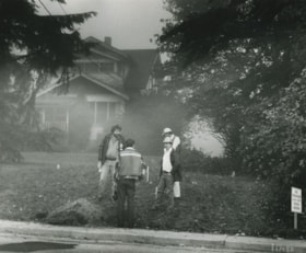
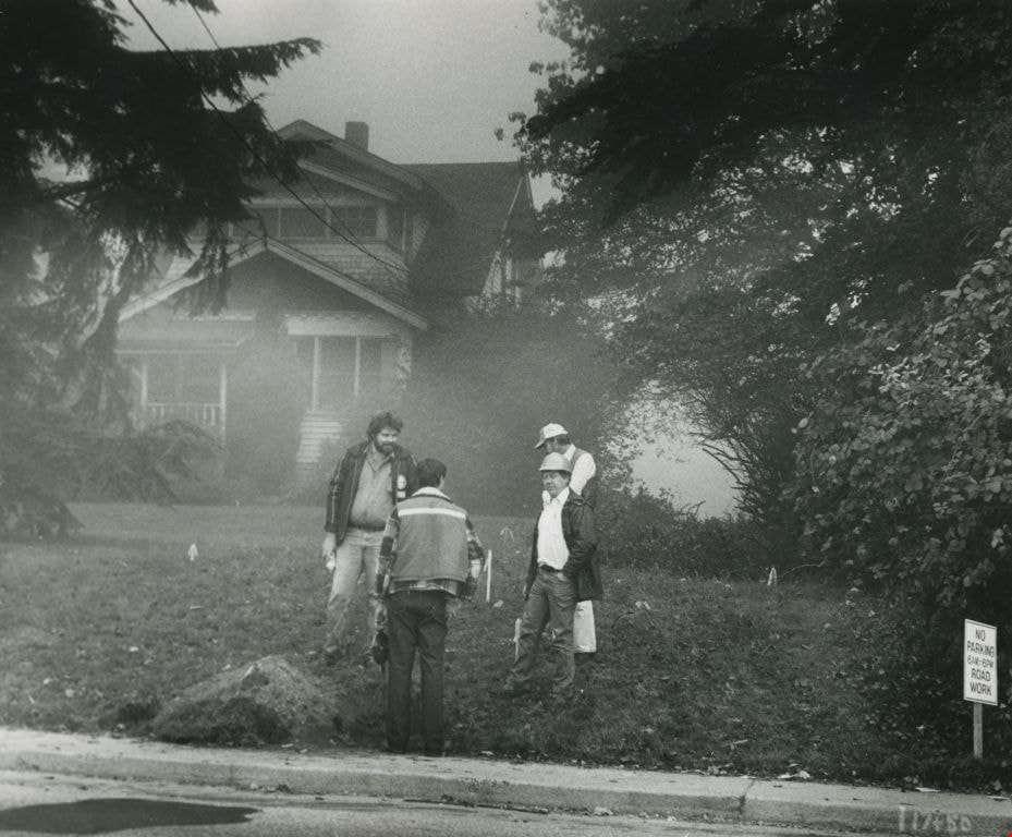
- Photograph of a municipal crew surveying Lillian Mann's property.
- Repository
- City of Burnaby Archives
- Date
- March 1982
- Collection/Fonds
- Columbian Newspaper collection
- Physical Description
- 1 photograph : b&w ; 19.5 x 23.5 cm
- Description Level
- Item
- Record No.
- 480-1117
- Access Restriction
- No restrictions
- Reproduction Restriction
- No restrictions
- Accession Number
- 2003-02
- Scope and Content
- Photograph of a municipal crew surveying Lillian Mann's property.
- Subjects
- Occupations - Civic Workers
- Media Type
- Photograph
- Photographer
- King, Basil
- Notes
- Title based on contents of photograph
- Quote originally appeared in the Columbian newspaper in march of 1982, and was a quote from municipal engineer Ernie Olson
- Geographic Access
- Cameron Street
- Historic Neighbourhood
- Burquitlam (Historic Neighbourhood)
- Planning Study Area
- Lyndhurst Area
Images
![Louis Claude Hill's Farm, Burnaby, BC, [1909] thumbnail](/media/hpo/_Data/_BVM_Images/1973/1973_0040_0004_001.jpg?width=280)
Louis Claude Hill's Farm, Burnaby, BC
https://search.heritageburnaby.ca/link/museumdescription3064
- Repository
- Burnaby Village Museum
- Date
- [1909]
- Collection/Fonds
- Burnaby Village Museum Photograph collection
- Description Level
- Item
- Physical Description
- 1 photograph : b&w ; 12.2 x 17.6 cm mounted on cardboard 22.7 x 27.4 cm
- Scope and Content
- Photograph of a farm with men, a horse and wagon, and children in a field. An annotation on the back of one of the photos reads, "The foreground farm property stood at the corner of Sperling Avenue (formerly known as the Pole Line Road) and Buckingham. The white house in the left centre was the …
- Repository
- Burnaby Village Museum
- Collection/Fonds
- Burnaby Village Museum Photograph collection
- Description Level
- Item
- Physical Description
- 1 photograph : b&w ; 12.2 x 17.6 cm mounted on cardboard 22.7 x 27.4 cm
- Scope and Content
- Photograph of a farm with men, a horse and wagon, and children in a field. An annotation on the back of one of the photos reads, "The foreground farm property stood at the corner of Sperling Avenue (formerly known as the Pole Line Road) and Buckingham. The white house in the left centre was the residence of Miss Woodward, her mother and sister. It was the first post office at 'Burnaby Lake' and the site of the kindergarten school of Miss Harriet Woodward. It later became the United Church. / The open field in the distance above the horse's head and people in the field is the field in front of the 'Manor House' which was built by Mr. Bateman in the 1920's. To the right of and beyond the white house partly hidden by the trees can be seen some of the buildings associated with the Hill farm on Deer Lake Ave. which by the date (1909) of this photo had been sold. The distant tall trees (center) stand on the site of the Municipal Buildings (DesBirsays Woods)." An annotation on the back of the other photograph reads, "Formerly belonging to Malcom Nicolson / App. 1908." Annotations at the bottom front of the photograph read, "L. Claude Hill's Farm, Burnaby, BC."
- Subjects
- Agriculture - Crops
- Agricultural Tools and Equipment
- Animals - Horses
- Occupations - Farmers
- Agriculture - Farms
- Geographic Access
- Buckingham Avenue
- Sperling Avenue
- Accession Code
- HV973.40.4
- Access Restriction
- No restrictions
- Reproduction Restriction
- No known restrictions
- Date
- [1909]
- Media Type
- Photograph
- Historic Neighbourhood
- Burnaby Lake (Historic Neighbourhood)
- Planning Study Area
- Morley-Buckingham Area
- Scan Resolution
- 600
- Scan Date
- 2023-05-09
- Scale
- 100
- Notes
- Title based on contents of photograph
- 1 b&w duplicate photograph accompanying
- Text on first image "L Claude Hill's Farm, Burnaby B C", incorporated into the image at the bottom edge of the photograph. "app 1909" pencilled in following above on the bottom edge of the image "L. Claude / Hill / Broadview", pencilled on the matt below the image. "The foreground farm property stood at the / Corner of Sperling Ave. (formerly known as Pole Line Road) / and Buckingham. The white house in the left / centre was the residence of Miss Woodward, her mother / and sister. It was the first post ofice at "Burnaby Lake" / and the site of the kindergarten school of Miss / Harriet Woodward. It later became the United / Church. / The open field in the distance above / the horses head and people in the field is / the field in front of the "Manse House" which / was built by Mr. Bateman in the 1920's. To the / right of and beyond the white house partly hidden / by the trees can be seen some of the buildings / associated with the Hill farm on Deer Lake Ave. / which by the date (1909) of this photo had been / sold. The distant tall trees (center) stand on the site of / the Municipal Buildings (DesBirsays Woods)", hand written in blue ink on the reverse side of the matt. It is not indicated who wrote the note. "OR MASTER / 973.40.4", pencilled in the lower right corner of reverse side of matt. "W. T. COOKSLEY / NEW WESTMINSTER, B.C."printed with very little contrast on the gray mattboard, below the lower right corner of the photograph Text on second image. "L Claude Hill's Farm, Burnaby B C", incorporated into the image at the bottom edge of the photograph. "Claude surveying the haying", pencilled on the reverse side of the matt. "Formerly belonging to Malcolm Nicholson / app 1908", hand writen in blue ink on the reverse side of the matt. "H.V.973.40.4. OR. MASTER", hand printed on the bottom left corner of the reverse side of the matt. "W. T. COOKSLEY / NEW WESTMINSTER, B.C."printed with very little contrast on the gray mattboard, below the lower right corner of the photograph
Images
![Louis Claude Hill's Farm, Burnaby, BC, [1909] thumbnail](/media/hpo/_Data/_BVM_Images/1973/1973_0040_0004_001.jpg)
