Narrow Results By
Subject
- Agricultural Tools and Equipment - Plows 3
- Agriculture 1
- Agriculture - Farms 4
- Animals - Birds 4
- Animals - Cows 1
- Animals - Fish 1
- Buildings - Commercial - Automobile Dealerships 1
- Buildings - Commercial - Restaurants 1
- Buildings - Commercial - Stores 1
- Buildings - Industrial 1
- Buildings - Residential - Houses 1
- Buildings - Schools 1
Person / Organization
- Avendaño, Adrian 1
- Boundary Road Lumber Mill 1
- British Columbia Electric Railway Company 2
- Burnaby Fire Department 1
- Burnaby Lake Park Association 1
- Burnaby Village Museum 2
- Ceperley, H.T. 2
- Chan, Puy Yuen 2
- Gnome Publications 1
- Green, George 1
- Hart, Frederick John, 1884-1945 2
- Haszard, Arthur de Windt 2

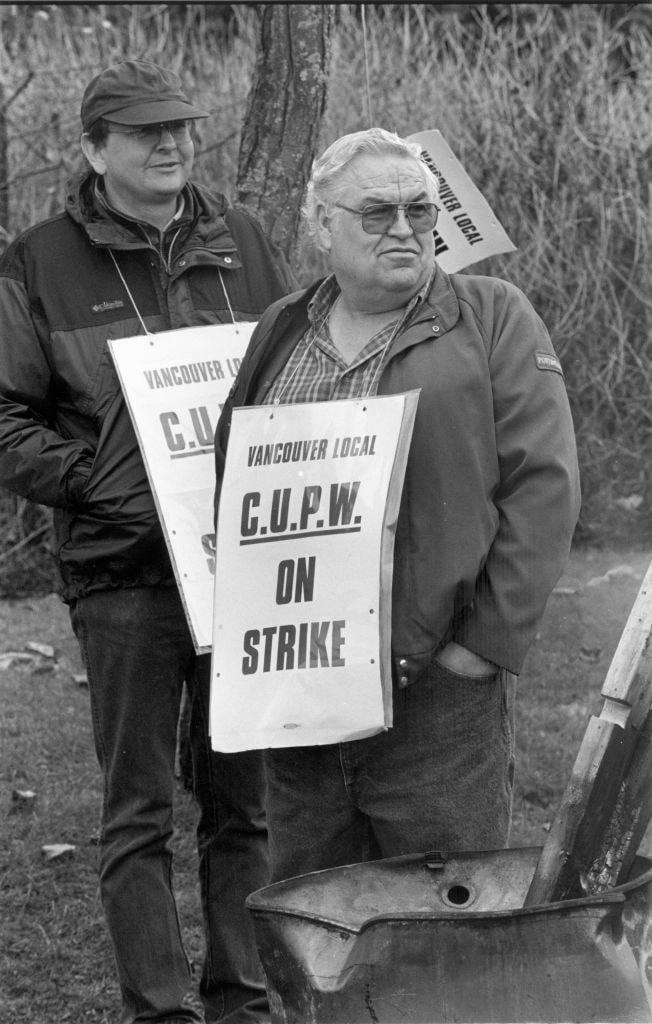
On Strike
https://search.heritageburnaby.ca/link/archivedescription80743
- Repository
- City of Burnaby Archives
- Date
- November 23, 1997
- Collection/Fonds
- Burnaby NewsLeader photograph collection
- Description Level
- Item
- Physical Description
- 1 photograph : b&w ; 22.5 x 14.5 cm
- Scope and Content
- Photograph of two unidentified postal workers outside the parcel distribution centre near Still Creek in Burnaby wearing "Vancouver Local C.U.P.W. on Strike" signs around their necks.
- Repository
- City of Burnaby Archives
- Date
- November 23, 1997
- Collection/Fonds
- Burnaby NewsLeader photograph collection
- Physical Description
- 1 photograph : b&w ; 22.5 x 14.5 cm
- Description Level
- Item
- Record No.
- 535-1005
- Access Restriction
- No restrictions
- Reproduction Restriction
- No reproduction permitted
- Accession Number
- 2012-11
- Scope and Content
- Photograph of two unidentified postal workers outside the parcel distribution centre near Still Creek in Burnaby wearing "Vancouver Local C.U.P.W. on Strike" signs around their necks.
- Media Type
- Photograph
- Notes
- Title based on contents of photograph
- Note in black ink on recto of photograph reads: "2638 Bby Mario / 60% Bby p. 5"
- Trim marks and/or reproduction instructions on recto (scan is cropped)
Images
Rezoning Applications
https://search.heritageburnaby.ca/link/councilreport60749
- Repository
- City of Burnaby Archives
- Report ID
- 101050
- Meeting Date
- 30-May-2016
- Format
- Council - Manager's Report
- Item No.
- 15
- Collection/Fonds
- City Council and Office of the City Clerk fonds
- Repository
- City of Burnaby Archives
- Report ID
- 101050
- Meeting Date
- 30-May-2016
- Format
- Council - Manager's Report
- Item No.
- 15
- Collection/Fonds
- City Council and Office of the City Clerk fonds
Documents
Rezoning Applications
https://search.heritageburnaby.ca/link/councilreport61057
- Repository
- City of Burnaby Archives
- Report ID
- 101165
- Meeting Date
- 25-Jul-2016
- Format
- Council - Manager's Report
- Item No.
- 26
- Collection/Fonds
- City Council and Office of the City Clerk fonds
- Repository
- City of Burnaby Archives
- Report ID
- 101165
- Meeting Date
- 25-Jul-2016
- Format
- Council - Manager's Report
- Item No.
- 26
- Collection/Fonds
- City Council and Office of the City Clerk fonds
Documents
Rezoning Reference # 12-35, New Automobile Dealership
https://search.heritageburnaby.ca/link/councilreport58807
- Repository
- City of Burnaby Archives
- Report ID
- 92026
- Meeting Date
- 25-Feb-2013
- Format
- Council - Manager's Report
- Item No.
- 5
- Collection/Fonds
- City Council and Office of the City Clerk fonds
- Repository
- City of Burnaby Archives
- Report ID
- 92026
- Meeting Date
- 25-Feb-2013
- Format
- Council - Manager's Report
- Item No.
- 5
- Collection/Fonds
- City Council and Office of the City Clerk fonds
Documents
Rezoning Reference #16-16; Skysign on Existing Building Willingdon Business Park
https://search.heritageburnaby.ca/link/councilreport68811
- Repository
- City of Burnaby Archives
- Report ID
- 101388
- Meeting Date
- 23-Jan-2017
- Format
- Council - Manager's Report
- Item No.
- 15
- Collection/Fonds
- City Council and Office of the City Clerk fonds
- Repository
- City of Burnaby Archives
- Report ID
- 101388
- Meeting Date
- 23-Jan-2017
- Format
- Council - Manager's Report
- Item No.
- 15
- Collection/Fonds
- City Council and Office of the City Clerk fonds
Documents

Rooted : Chinese Canadian stories in Burnaby
https://search.heritageburnaby.ca/link/museumlibrary7646
- Repository
- Burnaby Village Museum
- Publication Date
- 2023
- Call Number
- 971.133 ROO
and Gordon continued
their education before embarking on their careers.
For approximately forty-three years, Douglas Road
Farm at Douglas Road and Still Creek Avenue grew
and supplied fresh produce to Burnaby families and
Chinese Canadian restaurants and greengrocers in
Chinatown in Vancouver. My grandfather
- Repository
- Burnaby Village Museum
- Collection
- Digital Reference Collection
- Material Type
- Digital Resource
- ISBN
- 978-0-9689849-2-5
- Call Number
- 971.133 ROO
- Contributor
- Fong, Denise
- Lemke, Jane
- Codd, Lisa
- Place of Publication
- Burnaby
- Publisher
- City of Burnaby
- Publication Date
- 2023
- Printer
- Metropolitan Fine Printers
- Physical Description
- 203 p. : ill. ; 30.5 cm
- Library Subject (LOC)
- Chinese Canadians--British Columbia--Burnaby--History
- Race discrimination -- Canada
- Subjects
- Persons - Chinese Canadians
- Agriculture
- Agriculture - Farms
- Persons - Families
- Rights
- Rights - Human Rights
- Social Issues
- Social Issues - Racism
- Notes
- There are two versions of the book: English and Simplified Chinese (left, below) and the other in English and Traditional Chinese (right, below).
- From the late 1800s to the present day, Chinese Canadians have made Burnaby into a more vibrant and livable city. Rooted: Chinese Canadian Stories in Burnaby brings together a collection of diverse stories and photographs from the community, celebrating the legacy and contributions of Burnaby’s Chinese Canadian community spanning over a century. This coffee-table book features oral histories and interviews with descendants of multigenerational family farms, green grocers, corner stores, restaurants, and places of worship. Also included are archival research and community perspectives on anti-Asian racism, community activism, courage, and resilience.
- The publication has been timed to coincide with the 100th anniversary of the introduction of the Chinese Exclusion Act by the Government of Canada in 1923. This federal legislation followed decades of discriminatory legislation by Canada’s federal, provincial and municipal governments that targeted Chinese Canadians by limiting opportunities to live, work and raise families in Canada. The Chinese Exclusion Act banned almost all migration from China and remained in place until 1947. Publishing this book in 2023 is an effort by the City of Burnaby to recognize the impact of discriminatory legislation on Chinese Canadians in our community, including discriminatory bylaws and practices implemented by Burnaby’s early municipal government.
- Edited by Denise Fong (Lead Researcher), Jane Lemke (Burnaby Village Museum Curator) and Lisa Codd (City of Burnaby Heritage Planner).
Images

Digital Books
![Survey and Subdivision plans in New Westminster District Group 1 – Burnaby, [1905-1917] thumbnail](/media/hpo/_Data/_BVM_Cartographic_Material/1977/1977_0093_0022a_001.jpg?width=280)
Survey and Subdivision plans in New Westminster District Group 1 – Burnaby
https://search.heritageburnaby.ca/link/museumdescription6991
- Repository
- Burnaby Village Museum
- Date
- [1905-1917]
- Collection/Fonds
- Burnaby Village Museum Map collection
- Description Level
- File
- Physical Description
- 12 plans : 6 black ink on paper + 2 black & col. ink on paper + 4 graphite on paper
- Scope and Content
- Item consists of a large board of six New Westminster District subdivision plans mounted on one side and six New Westminster District subdivision plans mounted on the other side. Side A: 1. Plan drawn in graphite with markings in black ink "Surveyed for Mr. W. Wilson / Paterson Stat. B.C.E.R." . …
- Repository
- Burnaby Village Museum
- Collection/Fonds
- Burnaby Village Museum Map collection
- Description Level
- File
- Physical Description
- 12 plans : 6 black ink on paper + 2 black & col. ink on paper + 4 graphite on paper
- Material Details
- Scales [between 1:360 and 1:3168]
- Index number on edge of board reads: "22"
- Scope and Content
- Item consists of a large board of six New Westminster District subdivision plans mounted on one side and six New Westminster District subdivision plans mounted on the other side. Side A: 1. Plan drawn in graphite with markings in black ink "Surveyed for Mr. W. Wilson / Paterson Stat. B.C.E.R." . Plan includes subdivision of lots situated between B.C.E. Railway and Vancouver Road (Kingsway). (Geographic location: Burnaby) 2. Subdivision plan (no title) drawn in black ink with annotations in graphite. Plan covers District Lots 2, 4 and 6, west of North Road. Plan is stamped: "Albert J. Hill, Civil Engineer / and / Provincial Land Surveyor, / New Westminster, / B.C. (Geographic location: Burnaby) 3. Plan of "Portion of Municipality" with intials "RB" [sic] (handwritten in blue crayon). Plan covers the area north east of the City of New Westminster including District Lots 11, 13, 14, 12, 1 and 2. Plan is stamped: "Albert J. Hill, Civil Engineer / and / Provincial Land Surveyor, / New Westminster, / B.C. (Geographic location: Burnaby) 4."Plan / of Subdivision of / N.W.1/4 Lot 175 / Group 1 New West. Dist. / B.C. / Scale 4 chs = 1 in. " Plan is stamped: "Albert J. Hill, Civil Engineer / and / Provincial Land Surveyor, / New Westminster, / B.C. and initialed : "RB" [sic] (in blue pencil crayon) (Geographic location: Burnaby) 5. "Subdivision / of a Portion of / Lot 15 Group 1 / New Westminster Dist. / Scale 4 chs = 1 in". Plan provides numbered sudivisions - Lots 1 to 15 of District Lot 15 in red ink. (Geographic location: Burnaby) 6. Plan of "Central Park & / Vicinity" Plan includes subdivisions of District Lot 153 east of Central Park District Lot 151 and subdivision of District Lot 36 and 49 west of Boundary Road (Vancouver). Plan is stamped: "Albert J. Hill, Civil Engineer / and / Provincial Land Surveyor, / New Westminster, / B.C. and initialed : "RB" [sic] (in blue pencil crayon). (Geographic location: Burnaby) Side B: 1. Subdivision plan (no title) drawn in black ink. Plan identifies lots between Vancouver Road (Yale Road is crossed out and replaced with Vancouver Road) and B.C.E. Railway. "Scale 2 chs = 1 in" (Geographic location: Burnaby) 2. Plan of "Subdivision Lot 1 / Lot 69 Gr. 1 / Scale 30' = 1 " " Plan identifies Boundary Road, Still Creek and a Road Allowance between District Lot 118 and District Lot 69. Plan was "Surveyed for Burnaby Mun. Council / March 11th 1908 / G.K.B." (Geographic location: Burnaby) 3. Plan drawn in black ink (no title) showing a subdivision in Lot 25 with names "Newcomb", "Debeck" and "Armstrong" along with roads identified as Third Street, Cumberland Street, Armstrong Street and Cariboo [sic] Street and including Lots 27, 11 and 13.Plan is stamped: "Albert J. Hill, Civil Engineer / and / Provincial Land Surveyor, / New Westminster, / B.C. and initialed : "RB" [sic] (in blue pencil crayon). (Geographic location: Burnaby) 4. Handrawn subdivision plan in graphite titled: "Lot 13, Gr.1" with intials "RB" [sic] (handwritten in blue crayon). Plan is bordered by Armstrong Street (Lot 11, G.1), Cumberland St. (Lot 25, G.1) and Tenth Avenue (City Boundary). The plan is singed by "Albert J. Hill / P.L.S." and one of the subdivided lots is identified with the name: "W. Karrymann". (Geographic location: Burnaby) 5. Handrawn sketch in graphite titled: "Lot 88, Gr.1" with intials "RB" [sic] (handwritten in blue crayon). Plan appears to be a draft of a subdivision plan of a portion of District Lot 88 along Cumberland Road. The plan is signed: "16/7/17 _W.F. Draper [sic] / B.C.L.S." (Geographic location: Burnaby) 6. "Plan / of Subdivision / of Blocks 61, 62 and 2 / Lot 30 / Group 1 / N.W. Dist. / Scale 1ch = 1 in". Plan is intialed by: "PB" with a note: "Also see board 2 / for duplicate" (handwritten in blue crayon). (Geographic location: Burnaby)
- Creator
- Hill, Albert James
- Geographic Access
- Boundary Road
- Kingsway
- Cumberland Street
- Accession Code
- HV977.93.22
- Access Restriction
- No restrictions
- Reproduction Restriction
- No known restrictions
- Date
- [1905-1917]
- Media Type
- Cartographic Material
- Historic Neighbourhood
- Central Park (Historic Neighbourhood)
- Scan Resolution
- 300
- Scale
- 100
- Notes
- Title based on contents of file
- Scale is measured in chains and feet. (One chain equals 792 inches)
- The term "Lot" can also refer to a "District Lot”
- Some plans are stamped: "Albert J. Hill, Civil Engineer / and / Provincial Land Surveyor, / New Westminster, / B.C." and intialed: "RB" [sic]
Images
![Survey and Subdivision plans in New Westminster District Group 1 – Burnaby, [1905-1917] thumbnail](/media/hpo/_Data/_BVM_Cartographic_Material/1977/1977_0093_0022a_001.jpg)

Work Order 60-13-005
https://search.heritageburnaby.ca/link/councilreport16669
- Repository
- City of Burnaby Archives
- Report ID
- 6238
- Meeting Date
- 26-Nov-1984
- Format
- Council - Manager's Report
- Manager's Report No.
- 75
- Item No.
- 16
- Collection/Fonds
- City Council and Office of the City Clerk fonds
- Repository
- City of Burnaby Archives
- Report ID
- 6238
- Meeting Date
- 26-Nov-1984
- Format
- Council - Manager's Report
- Manager's Report No.
- 75
- Item No.
- 16
- Collection/Fonds
- City Council and Office of the City Clerk fonds
Documents
Work Order Nos. 60-13-004, 60-08-011, 60-14-075, 60-14-072, 60-14-073 and 60-14-074
https://search.heritageburnaby.ca/link/councilreport17338
- Repository
- City of Burnaby Archives
- Report ID
- 707
- Meeting Date
- 12-Dec-1983
- Format
- Council - Manager's Report
- Manager's Report No.
- 74
- Item No.
- 14
- Collection/Fonds
- City Council and Office of the City Clerk fonds
- Repository
- City of Burnaby Archives
- Report ID
- 707
- Meeting Date
- 12-Dec-1983
- Format
- Council - Manager's Report
- Manager's Report No.
- 74
- Item No.
- 14
- Collection/Fonds
- City Council and Office of the City Clerk fonds