Narrow Results By
Subject
- Agriculture - Crops 2
- Agriculture - Farms 1
- Agriculture - Fruit and Berries 4
- Building Components 1
- Buildings - Agricultural 2
- Buildings - Agricultural - Greenhouses 2
- Buildings - Commercial - General Stores 1
- Buildings - Heritage 2
- Buildings - Industrial - Factories 3
- Buildings - Industrial - Powerhouses 4
- Buildings - Public - Detention Facilities 1
- Buildings - Residential 1
Proposed Treatment Plant - Foot of Marsh Avenue
https://search.heritageburnaby.ca/link/councilreport39555
- Repository
- City of Burnaby Archives
- Report ID
- 36319
- Meeting Date
- 13-Nov-1961
- Format
- Council - Manager's Report
- Manager's Report No.
- 60
- Item No.
- 5
- Collection/Fonds
- City Council and Office of the City Clerk fonds
- Repository
- City of Burnaby Archives
- Report ID
- 36319
- Meeting Date
- 13-Nov-1961
- Format
- Council - Manager's Report
- Manager's Report No.
- 60
- Item No.
- 5
- Collection/Fonds
- City Council and Office of the City Clerk fonds
Documents
![Robert Prittie, [1969] thumbnail](/media/Hpo/_Data/_Archives_Images/_Unrestricted/316/368-004.jpg?width=280)
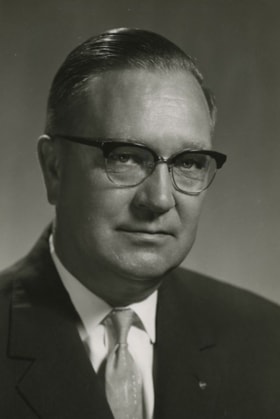
Robert Prittie
https://search.heritageburnaby.ca/link/archivedescription58736
- Repository
- City of Burnaby Archives
- Date
- [1969]
- Collection/Fonds
- Burnaby Historical Society fonds
- Description Level
- Item
- Physical Description
- 1 photograph : col.
- Scope and Content
- Photograph of Robert Prittie (standing in center) making remarks at the Official Opening of the Sinclair Radio Laboratories ltd. plant.
- Repository
- City of Burnaby Archives
- Date
- [1969]
- Collection/Fonds
- Burnaby Historical Society fonds
- Subseries
- Robert Prittie subseries
- Physical Description
- 1 photograph : col.
- Description Level
- Item
- Record No.
- 368-004
- Access Restriction
- No restrictions
- Reproduction Restriction
- Reproduce for fair dealing purposes only
- Accession Number
- BHS1999-01
- Scope and Content
- Photograph of Robert Prittie (standing in center) making remarks at the Official Opening of the Sinclair Radio Laboratories ltd. plant.
- Subjects
- Events - Openings
- Names
- Prittie, Robert W. "Bob"
- Media Type
- Photograph
Images
![Robert Prittie, [1969] thumbnail](/media/Hpo/_Data/_Archives_Images/_Unrestricted/316/368-004.jpg)

Shell Oil Company
https://search.heritageburnaby.ca/link/landmark675
- Repository
- Burnaby Heritage Planning
- Geographic Access
- Kensington Avenue
- Associated Dates
- ca. 1930-1993
- Heritage Value
- After considering several sites in the Greater Vancouver area, the Shell Oil Company chose 70 acres in North Burnaby with frontage of one third of a mile on Burrard Inlet. Shell proposed to build a four-million dollar plant that would employ up to 2000 - providing some relief in the middle of Burnaby's economic crisis of the Depression years. The site became known as the Shellburn Refinery and was in operation until 1993.
- Historic Neighbourhood
- Lochdale (Historic Neighbourhood)
- Planning Study Area
- Westridge Area
Images

![Small child sitting on the grass, [between 1940 and 1960] thumbnail](/media/hpo/_Data/_BVM_Images/2007/2007_0020_0013_001.jpg?width=280)
Small child sitting on the grass
https://search.heritageburnaby.ca/link/museumdescription4390
- Repository
- Burnaby Village Museum
- Date
- [between 1940 and 1960]
- Collection/Fonds
- Rhoda Jeffers fonds
- Description Level
- Item
- Physical Description
- 1 photograph : b&w ; 11 x 6.5 cm
- Scope and Content
- Photograph of an unidentified young child sitting on the grass beside a small wheelbarrow. The child is wearing polka dot shorts, a white top and is barefoot. There is a wooden fence behind with some flowering plants along the bottom.
- Repository
- Burnaby Village Museum
- Collection/Fonds
- Rhoda Jeffers fonds
- Description Level
- Item
- Physical Description
- 1 photograph : b&w ; 11 x 6.5 cm
- Scope and Content
- Photograph of an unidentified young child sitting on the grass beside a small wheelbarrow. The child is wearing polka dot shorts, a white top and is barefoot. There is a wooden fence behind with some flowering plants along the bottom.
- Accession Code
- BV007.20.13
- Access Restriction
- No restrictions
- Reproduction Restriction
- May be restricted by third party rights
- Date
- [between 1940 and 1960]
- Media Type
- Photograph
- Scan Resolution
- 600
- Scan Date
- 24/04/2018
- Notes
- Title based on content of photograph
Images
![Small child sitting on the grass, [between 1940 and 1960] thumbnail](/media/hpo/_Data/_BVM_Images/2007/2007_0020_0013_001.jpg)
Small family fonds
https://search.heritageburnaby.ca/link/archivedescription91819
- Repository
- City of Burnaby Archives
- Date
- 1922-2016
- Collection/Fonds
- Small family fonds
- Description Level
- Fonds
- Physical Description
- 75 photographs : b&w & col. + 1 plan
- Scope and Content
- Fonds consists of photographs documenting the transformation of the Burnaby Lake area of Burnaby, B.C. from semi-rural in the 1920s to urbanized in 2016. Photographs depict the land and houses located on the corner of Douglas Road and Dominion Street as the property was rezoned and its density quad…
- Repository
- City of Burnaby Archives
- Date
- 1922-2016
- Collection/Fonds
- Small family fonds
- Physical Description
- 75 photographs : b&w & col. + 1 plan
- Description Level
- Fonds
- Access Restriction
- Open access
- Reproduction Restriction
- May be restricted by third party rights
- Accession Number
- 2017-01
- Scope and Content
- Fonds consists of photographs documenting the transformation of the Burnaby Lake area of Burnaby, B.C. from semi-rural in the 1920s to urbanized in 2016. Photographs depict the land and houses located on the corner of Douglas Road and Dominion Street as the property was rezoned and its density quadrupled. Fonds also includes photographs of the Small family house being moved to 5496 Dominion Street and the original landscape plan for 5118 Douglas Road.
- History
- In 1915, John W. Roberts and his wife Mary Allen Roberts moved from the United States to Canada along with their daughter, Lauretta. On first moving to Canada, the family lived in a rented house in Vancouver and John worked as a movie projectionist in the city. The couple had three more children, all sons: John A., Edward, and Roland. Circa 1921, John purchased a large parcel of land at the corner of Douglas Road and Dominion Street in Burnaby. This parcel encompassed the equivalent of at least six 66-foot lots along the south side of Dominion Street and the same along the north side of Norfolk Street. On their property, a barn and small living quarters were built. The family moved in, raising goats and growing potatoes to supplement their income. They also planted cherry, apple, and pear trees; hazelnut and walnut trees; raspberries; and a large vegetable garden, the fruits of which Mary preserved for year-round use. At this time, agricultural activities were common for families in the area: the Roberts' neighbours kept chickens for personal use and for selling eggs; grew mushrooms for commercial sale; and sold manure from an old buckboard drawn by Clydesdale horses. John built a new house in the middle of the Roberts’ lots on the southwest corner of Douglas Road and Dominion Street. The house faced Douglas Road and overlooked a large, well-landscaped front yard to the east and a full-sized, clay tennis court to the north. The family moved into this new house in 1925. When the Roberts ceased raising goats, the barn and original living quarters were reduced to a double-car garage with storage space plus a sawdust-insulated “root cellar”. John also built a house on the northwest corner of the lot at Douglas Road and Dominion Street (3093 Douglas Road), which was purchased by the Hardy family. In 1957, part of this property (3071 Douglas Road) was sold to the Brocklebanks who built a house and lived there. In addition, John built a house at the northwest corner of Douglas Road and Norfolk Street (5106 Douglas Road). The original purchaser of this house is unknown, but in 1949, it was bought by the Meyers family. In 1952 or 1953, the Meyers sold part of this property and the Manahans built a house on it, facing Douglas Road. Several other lots that John owned were also sold off over the years. By the 1950s, John owned only five 66-foot lots from Douglas Road west, along the south side Dominion Street. In 1954, John sold the lot furthest from Douglas Road (5486 Dominion Street) to a builder who built a “ranch-style” house and put it up for sale. John retired from his career as a movie projectionist in the 1950s. He, Mary, and Lauretta retained their US citizenship all their lives, although they never returned to the USA except for brief visits. John A., Edward, and Roland who, as children of US citizens, also had US citizenship, eventually moved to the US, where they remained for the rest of their lives. In 1945, Lauretta married Frederick Small. The couple lived in a rented house in Vancouver for a few years before moving in with John and Mary in Burnaby. The couple had four children: Elizabeth, Kathryn, Charles, and Martin. In 1955, Frederick purchased the rancher at 5486 Dominion Street and the family moved in. The Small children grew up enjoying the freedom of having their grandparent’s large property in addition to their parent’s yard to play in. The back lane that ran between Dominion Street and Norfolk Street was filled with trees and bushes, creating a narrow bit of “forest” to explore. In 1957, John died. Mary died in 1969, as did Frederick. Lauretta was executor for her mother’s and husband’s estates. After much consideration, she decided to sell the house at 5486 Dominion Street and move back into her childhood home. By doing so, she was able to settle her mother’s estate to the satisfaction of her brothers. Elizabeth married and moved away. Over the next few years, the “Roberts” house was home to Lauretta, Kathryn, Charles, and Martin, with the three grown children moving in and out several times during the 1970s. In 1981, Lauretta died. Her children discussed at length how to divide up the property, which consisted of four 66-foot lots, according to her will. None of her children wanted to see the old family house destroyed but the house straddled two lots. They finally decided that if one of them wanted to pay to move the house to sit on one of the lots, the “value” of the house would not enter into the settlement of the estate. Kathryn chose to do this. In 1982, the old house was moved to 5496 Dominion Street and Kathryn continued to live in it. Martin died in 1982. Elizabeth and Charles each inherited one lot and the last lot, which would have gone to Martin, was sold, the funds divided equally between Elizabeth, Kathryn, and Charles. The three lots between 5496 Dominion Street and Douglas Road were subdivided into 33-foot lots and six new houses were built. In 1993, the Meyers property and the Manahan property were subdivided into 33-foot lots facing Norfolk Street and the old houses were torn down and four new houses were built.
- Media Type
- Photograph
- Technical Drawing
- Creator
- Small family
South Burnaby Garden Club correspondence
https://search.heritageburnaby.ca/link/archivedescription57880
- Repository
- City of Burnaby Archives
- Date
- 1962
- Collection/Fonds
- Burnaby Historical Society fonds
- Description Level
- File
- Physical Description
- 1 file of textual records
- Scope and Content
- File contains correspondence pertaining to the South Burnaby Garden Club, as well as information on various plants, fertilizers and garden fairs.
- Repository
- City of Burnaby Archives
- Date
- 1962
- Collection/Fonds
- Burnaby Historical Society fonds
- Subseries
- South Burnaby Garden Club subseries
- Physical Description
- 1 file of textual records
- Description Level
- File
- Record No.
- MSS028-026
- Accession Number
- BHS1986-36
- Scope and Content
- File contains correspondence pertaining to the South Burnaby Garden Club, as well as information on various plants, fertilizers and garden fairs.
- Media Type
- Textual Record
- Notes
- Title based on contents of file
South Burnaby Garden papers
https://search.heritageburnaby.ca/link/archivedescription57883
- Repository
- City of Burnaby Archives
- Date
- 1950-1961
- Collection/Fonds
- Burnaby Historical Society fonds
- Description Level
- File
- Physical Description
- 1 file of textual records
- Scope and Content
- File contains correspondence pertaining to the South Burnaby Garden Club, as well as information on various plants and fertilizers. Also included in the file is a Fall Show programme from the North Burnaby Horticultural Society.
- Repository
- City of Burnaby Archives
- Date
- 1950-1961
- Collection/Fonds
- Burnaby Historical Society fonds
- Subseries
- South Burnaby Garden Club subseries
- Physical Description
- 1 file of textual records
- Description Level
- File
- Record No.
- MSS028-029
- Accession Number
- BHS1986-36
- Scope and Content
- File contains correspondence pertaining to the South Burnaby Garden Club, as well as information on various plants and fertilizers. Also included in the file is a Fall Show programme from the North Burnaby Horticultural Society.
- Media Type
- Textual Record
- Notes
- Title based on contents of file

Sperling Avenue (Pole Line Road)
https://search.heritageburnaby.ca/link/landmark761
- Repository
- Burnaby Heritage Planning
- Associated Dates
- 1905
- Heritage Value
- The road currently known as Sperling Avenue was originally the "Pole Line Road" - so named because it served as the route for a power transmission line to connect the Buntzen Lake Power Plant to the Burnaby sub-station at Griffiths Avenue in 1905. It was named after Rochfort Henry Sperling, the Superintendant of the B.C.E.R. Company. The B.C. Electric Railway contracted Herbert Gilley to open the Pole Line Road from Hastings to Johnston Road, as Gilley Brothers were already actively logging the area.
- Historic Neighbourhood
- Burnaby Lake (Historic Neighbourhood)
- Planning Study Area
- Sperling-Broadway Area
- Lochdale Area
- Ardingley-Sprott Area
- Morley-Buckingham Area
Images

![Standing on tree stumps, [190-?] (date of original), copied 1977 thumbnail](/media/hpo/_Data/_BVM_Images/1977/1977_0123_0007_001.jpg?width=280)
Standing on tree stumps
https://search.heritageburnaby.ca/link/museumdescription601
- Repository
- Burnaby Village Museum
- Date
- [190-?] (date of original), copied 1977
- Collection/Fonds
- Burnaby Village Museum Photograph collection
- Description Level
- Item
- Physical Description
- 1 photograph : b&w ; 20.2 x 25.2 cm print
- Scope and Content
- Photograph of a group of people standing on tree stumps in the woods. On one stump, a man in a three piece suit, with a hat and a pipe in his mouth is squatting, and on another stump, two women in overcoats and hats and a man wearing a vest is standing together. The squatting man on the stump resem…
- Repository
- Burnaby Village Museum
- Collection/Fonds
- Burnaby Village Museum Photograph collection
- Description Level
- Item
- Physical Description
- 1 photograph : b&w ; 20.2 x 25.2 cm print
- Scope and Content
- Photograph of a group of people standing on tree stumps in the woods. On one stump, a man in a three piece suit, with a hat and a pipe in his mouth is squatting, and on another stump, two women in overcoats and hats and a man wearing a vest is standing together. The squatting man on the stump resembles Arthur Rowe, the husband of Winnie Hill Rowe, and son-in-law of Bernard Hill.
- Subjects
- Plants - Trees
- Accession Code
- HV977.123.7
- Access Restriction
- No restrictions
- Reproduction Restriction
- No known restrictions
- Date
- [190-?] (date of original), copied 1977
- Media Type
- Photograph
- Scan Resolution
- 600
- Scan Date
- 2023-07-18
- Notes
- Title based on contents of photograph
Images
![Standing on tree stumps, [190-?] (date of original), copied 1977 thumbnail](/media/hpo/_Data/_BVM_Images/1977/1977_0123_0007_001.jpg)
![Teachers at Burnaby West School, [between 1900 and 1910] thumbnail](/media/hpo/_Data/_BVM_Images/2012/2012_0020_0007_001.jpg?width=280)
Teachers at Burnaby West School
https://search.heritageburnaby.ca/link/museumdescription2944
- Repository
- Burnaby Village Museum
- Date
- [between 1900 and 1910]
- Collection/Fonds
- Burnaby Village Museum Photograph collection
- Description Level
- Item
- Physical Description
- 1 photograph : b&w oval ; 16 x 10 cm in decorative oval paper frame
- Scope and Content
- Photograph of five female teachers at West Burnaby School (renamed Kingsway West School). The group is standing in front of a stone wall.
- Repository
- Burnaby Village Museum
- Collection/Fonds
- Burnaby Village Museum Photograph collection
- Description Level
- Item
- Physical Description
- 1 photograph : b&w oval ; 16 x 10 cm in decorative oval paper frame
- Material Details
- Oval image of the five women surrounded by a white oval frame and then a black paper frame with plant silhouettes
- Scope and Content
- Photograph of five female teachers at West Burnaby School (renamed Kingsway West School). The group is standing in front of a stone wall.
- Subjects
- Occupations - Teachers
- Names
- Kingsway West School
- Geographic Access
- Kingsway
- Street Address
- 4800 Kingsway
- Accession Code
- BV012.20.7
- Date
- [between 1900 and 1910]
- Media Type
- Photograph
- Historic Neighbourhood
- Central Park (Historic Neighbourhood)
- Planning Study Area
- Maywood Area
- Related Material
- Another copy of the same image is accessioned as BV999.2.43.
- Scan Resolution
- 600
- Scan Date
- 13-Mar-2018
- Notes
- Title based on contents of photograph.
Images
![Teachers at Burnaby West School, [between 1900 and 1910] thumbnail](/media/hpo/_Data/_BVM_Images/2012/2012_0020_0007_001.jpg)
![Timber near Deer Lake, [1905] thumbnail](/media/hpo/_Data/_Archives_Images/_Unrestricted/477/477-748.jpg?width=280)
Timber near Deer Lake
https://search.heritageburnaby.ca/link/archivedescription39429
- Repository
- City of Burnaby Archives
- Date
- [1905]
- Collection/Fonds
- Peers Family and Hill Family fonds
- Description Level
- Item
- Physical Description
- 1 photograph : b&w ; 7.3 x 9.4 cm
- Scope and Content
- Photograph of an unidentified man standing beside a tree, holding an axe.
- Repository
- City of Burnaby Archives
- Date
- [1905]
- Collection/Fonds
- Peers Family and Hill Family fonds
- Physical Description
- 1 photograph : b&w ; 7.3 x 9.4 cm
- Description Level
- Item
- Record No.
- 477-748
- Access Restriction
- No restrictions
- Reproduction Restriction
- No known restrictions
- Accession Number
- 2007-12
- Scope and Content
- Photograph of an unidentified man standing beside a tree, holding an axe.
- Media Type
- Photograph
- Notes
- Title based on contents of photograph
- Geographic Access
- Deer Lake
- Historic Neighbourhood
- Burnaby Lake (Historic Neighbourhood)
Images
![Timber near Deer Lake, [1905] thumbnail](/media/hpo/_Data/_Archives_Images/_Unrestricted/477/477-748.jpg)
![Tom Cornforth measuring peas, [196-] (date of original), copied 1992 thumbnail](/media/hpo/_Data/_Archives_Images/_Unrestricted/315/315-264.jpg?width=280)
Tom Cornforth measuring peas
https://search.heritageburnaby.ca/link/archivedescription36806
- Repository
- City of Burnaby Archives
- Date
- [196-] (date of original), copied 1992
- Collection/Fonds
- Burnaby Historical Society fonds
- Description Level
- Item
- Physical Description
- 1 photograph : b&w ; 8.7 x 10.5 cm print
- Scope and Content
- Photograph of Tom Cornforth measuring the pea plants in the garden at his house on Royal Oak Avenue.
- Repository
- City of Burnaby Archives
- Date
- [196-] (date of original), copied 1992
- Collection/Fonds
- Burnaby Historical Society fonds
- Subseries
- Burnaby Centennial Anthology subseries
- Physical Description
- 1 photograph : b&w ; 8.7 x 10.5 cm print
- Description Level
- Item
- Record No.
- 315-264
- Access Restriction
- No restrictions
- Reproduction Restriction
- Reproduce for fair dealing purposes only
- Accession Number
- BHS1994-04
- Scope and Content
- Photograph of Tom Cornforth measuring the pea plants in the garden at his house on Royal Oak Avenue.
- Subjects
- Geographic Features - Gardens
- Names
- Cornforth, Tom
- Media Type
- Photograph
- Notes
- Title based on contents of photograph
- Geographic Access
- Royal Oak Avenue
- Historic Neighbourhood
- Burnaby Lake (Historic Neighbourhood)
- Planning Study Area
- Douglas-Gilpin Area
Images
![Tom Cornforth measuring peas, [196-] (date of original), copied 1992 thumbnail](/media/hpo/_Data/_Archives_Images/_Unrestricted/315/315-264.jpg)

Topping a tree near Central Park
https://search.heritageburnaby.ca/link/archivedescription37280
- Repository
- City of Burnaby Archives
- Date
- 1904
- Collection/Fonds
- Burnaby Historical Society fonds
- Description Level
- Item
- Physical Description
- 1 photograph : sepia toned ; 21 x 26.5 cm
- Scope and Content
- Photograph of a man "topping" a large tree in the area near Central Park and Boundary Road.
- Repository
- City of Burnaby Archives
- Date
- 1904
- Collection/Fonds
- Burnaby Historical Society fonds
- Subseries
- Norah Code subseries
- Physical Description
- 1 photograph : sepia toned ; 21 x 26.5 cm
- Description Level
- Item
- Record No.
- 345-001
- Access Restriction
- No restrictions
- Reproduction Restriction
- No known restrictions
- Accession Number
- BHS1997-05
- Scope and Content
- Photograph of a man "topping" a large tree in the area near Central Park and Boundary Road.
- Media Type
- Photograph
- Photographer
- Code, Norah
- Notes
- Title based on contents of photograph
- Photographs in this collection were taken and compiled by Norah Code, former editor of the "Burnaby Courier" newspaper during the course of her work for the newspaper. A note with the file indicates that the man in the tree may be Ms. Code's father but his name is not provided.
- Geographic Access
- Boundary Road
- Central Park
- Historic Neighbourhood
- Central Park (Historic Neighbourhood)
- Planning Study Area
- Maywood Area
Images

![Tramline tracks, [1905] thumbnail](/media/hpo/_Data/_BVM_Images/1990/199500100001.jpg?width=280)
Tramline tracks
https://search.heritageburnaby.ca/link/museumdescription3361
- Repository
- Burnaby Village Museum
- Date
- [1905]
- Collection/Fonds
- Burnaby Village Museum Photograph collection
- Description Level
- Item
- Physical Description
- 1 photograph : b&w ; 15 x 25.5 cm print
- Scope and Content
- Photograph of a British Columbia Electric Railway Company tramline track on Sixth Street and Twelfth Avenue. George Leaf's General Store, located at 7745 Sixth Street is visible on the left and Cliff's Car Factory located at 7730 Sixth Street is visible on the right. George Leaf's store burned down…
- Repository
- Burnaby Village Museum
- Collection/Fonds
- Burnaby Village Museum Photograph collection
- Description Level
- Item
- Physical Description
- 1 photograph : b&w ; 15 x 25.5 cm print
- Scope and Content
- Photograph of a British Columbia Electric Railway Company tramline track on Sixth Street and Twelfth Avenue. George Leaf's General Store, located at 7745 Sixth Street is visible on the left and Cliff's Car Factory located at 7730 Sixth Street is visible on the right. George Leaf's store burned down in 1913. The Car factory was established in 1902 and sometime in the 1920s, it became James Brookes Woodworking Plant.
- Subjects
- Transportation - Electric Railroads
- Buildings - Commercial - General Stores
- Buildings - Industrial - Factories
- Geographic Access
- 6th Street
- 12th Avenue
- Street Address
- 7730 6th Street
- 7745 6th Street
- Accession Code
- BV995.10.1
- Access Restriction
- No restrictions
- Date
- [1905]
- Media Type
- Photograph
- Historic Neighbourhood
- East Burnaby (Historic Neighbourhood)
- Planning Study Area
- Edmonds Area
- Notes
- Title based on contents of photograph
Images
![Tramline tracks, [1905] thumbnail](/media/hpo/_Data/_BVM_Images/1990/199500100001.jpg)
Vernon Tryson
https://search.heritageburnaby.ca/link/archivedescription45306
- Repository
- City of Burnaby Archives
- Date
- 1965, published November 24, 1965
- Collection/Fonds
- Columbian Newspaper collection
- Description Level
- Item
- Physical Description
- 1 photograph : b&w ; 18 x 12 cm
- Scope and Content
- Photograph of Vernon Tryson, president of Tryson & Son Iron Works Ltd. when the firm's Burnaby plant was opened. The firm was founded in 1930 by Vernon's father Fred Tryson in the basement of their family home. By 1965 it had become "a medium-size industry".
- Repository
- City of Burnaby Archives
- Date
- 1965, published November 24, 1965
- Collection/Fonds
- Columbian Newspaper collection
- Physical Description
- 1 photograph : b&w ; 18 x 12 cm
- Description Level
- Item
- Record No.
- 480-202
- Access Restriction
- No restrictions
- Reproduction Restriction
- Reproduce for fair dealing purposes only
- Accession Number
- 2003-02
- Scope and Content
- Photograph of Vernon Tryson, president of Tryson & Son Iron Works Ltd. when the firm's Burnaby plant was opened. The firm was founded in 1930 by Vernon's father Fred Tryson in the basement of their family home. By 1965 it had become "a medium-size industry".
- Media Type
- Photograph
- Notes
- Title based on contents of photograph
Images

Waplington family fonds
https://search.heritageburnaby.ca/link/museumdescription4613
- Repository
- Burnaby Village Museum
- Date
- 1911-2004
- Collection/Fonds
- Waplington family fonds
- Description Level
- Fonds
- Physical Description
- 1 album (88 photographs + textual records) + 2 photographs in frames
- Scope and Content
- Fonds consists of records documenting the lives of both the Waplington and Fleming families who resided at 3813 Deer Lake. Records include a family photograph album; two framed portraits: one of John Waplington and Doris Waplington (nee Caswell) (possibly on their wedding day) and Frances (nee Wapl…
- Repository
- Burnaby Village Museum
- Collection/Fonds
- Waplington family fonds
- Description Level
- Fonds
- Physical Description
- 1 album (88 photographs + textual records) + 2 photographs in frames
- Scope and Content
- Fonds consists of records documenting the lives of both the Waplington and Fleming families who resided at 3813 Deer Lake. Records include a family photograph album; two framed portraits: one of John Waplington and Doris Waplington (nee Caswell) (possibly on their wedding day) and Frances (nee Waplington) and Ray Fleming; a copy of a handwritten memoir "The Way it Was / 1913-1925"; as well as a computer printed copy of "In and Out of / A Cedar Shake Shack" / "The life of a little girl from World War I / to Canada's Diamond Jubilee" both written by Frances L. Fleming (nee Waplington). Fonds is arranged into series: 1) Waplington and Fleming families album series 2) Frances Fleming manuscripts series 3) Waplington family documents series 4) Waplington family photographs series
- History
- John (Jack) Waplington emigrated from Nottingham, England in 1904, arriving in Quebec City and continuing on to Ontario before eventually settling in British Columbia. Somewhere on his journey his right hand was crushed in an industrial accident and amputated. Following his recovery, Jack continued to work his way across Canada until he found employment at Stave Falls, B.C. and married Sarah Alice Cogswell (nee Nickerson). Jack and Sarah (nicknamed Cutie) Waplington had three children; Frances Louise Waplington (1913-2004), John Hazen Waplington and Grace Bancroft Waplington. In 1916, the Waplingtons rented the Walker house at Hill Station on the Burnaby Lake Interurban Line and in 1920 Jack built a cedar shack on 5 acres of land at 4925 Douglas Road (northwest corner of Douglas and Laurel). According to a memoir by Frances Waplington, life was rough living in the cedar shack on Douglas Road with no electricity or running water and by 1925 the family was lucky to purchase "Brookfield", the former home of Louis Claude Hill located at 3813 Deer Lake Avenue. The home was not in good shape having been empty for some time but was located on ¾ of an acre and purchased at a fair price of $1000. The house was surrounded by grass and flowers gone wild and very tall fir trees. The house had running water, electricity and was heated by a wood burning stove in the kitchen and hall and a fireplace in the living room. There was no refrigeration other than the ice box. The three Waplington children, Frances, John and Grace continued to attend Douglas Road School. The family renovated and restored the house at Deer Lake as well as the grounds, adding in flower and vegetable gardens. The large area of grass which formerly housed a tennis court was rolled flat and reseeded. Jack Waplington continued to work for the power company which became B.C. Electric Company and eventually B.C. Power and Hydro. The Waplingtons continued to live at 3813 Deer Lake until 1946 when they sold their home to their daughter Frances who married Ray Fleming. Jack and Sarah Waplington retired and moved to Lasquiti island. Frances "Fanny" Waplington married Reyland "Ray" Fleming October 11, 1935. Ray and Frances Fleming had three children; John (Jack) Reyland, Edith (Edie) Louise and Sara Maureen. In 1941 Ray was hired by the B.C. Electric Company to work at Buntzen Lake hydro station. There was no housing at the hydro station so the family lived on a 42’ coastal boat, the Cohoe Bay tied up to the dock at Buntzen Lake. Since it was war time, there was fear that the two hydro plants at Stave Falls and Buntzen Lake could be targeted for bombing so the Fleming family had to learn about air raid sirens, bunkers, helmets and gas masks. The children attended a one room classroom at Buntzen Lake and participated in school drills when the air raid siren sounded. By 1947 the Fleming family moved to the Waplington home at 3813 Deer lake Avenue after purchasing it from Frances’ parents. Ray continued to work for B.C. Electric and eventually B.C. Power and B.C. Hydro. The children walked or rode bicycles to and from Douglas Road School. At the time the family moved into their home there were no buses only the Interurban streetcar to take them to Vancouver. Douglas Road station was the nearest stop to Deer Lake on the Burnaby Lake Line. The closest neighbours were the Oakalla Prison farm (located off of Royal Oak hill overlooking Deer Lake) and the Ceperley mansion. Prison breaks were common and both the Waplington and Fleming families would often hear air raid sirens blare to warn them. The neighbourhood would go on high alert and the children would immediately run home to safety. Mr. Fleming was well prepared with his 22 rifle nearby should it be needed. After Sarah Waplington died, Jack Waplington returned to Deer Lake to live in a house trailer on the property that was owned by the Flemings. In 1959, after the Fleming children had grown and moved on, Ray and Frances Fleming sold the property to the Municipality of Burnaby. The Municipality rented it out for several years prior to its demolition around 1970 to make way for Burnaby’s Heritage Village. Frances Louise Fleming received her teaching degree from the Vancouver Normal School at the end of World War II but found it extremely difficult to secure a permanent teaching position as a woman. Between 1944 and 1954, Frances was hired and fired eight times from teaching positions despite excellent reports. Finally in 1954, she was invited to teach in an adjoining district with a permanent teaching appointment to follow. Over the years, Frances taught in Vancouver, Burnaby, Pender Harbour and served as vice principal at Magee Secondary. In the early 1970s Frances was appointed provincial superintendent of schools at Quesnel and then moved to Victoria to be assistant superintendent of integrated and supportive services and then in 1973, she became assistant superintendent of the department of public intstruction. Frances retired from teaching soon after, moving to the Sunshine Coast with her husband Ray. Frances was awarded the Order of British Columbia in 1997, was an accomplished writer who regularly contributed articles to the Vancouver Sun newspaper and othe publications. Ray Fleming died in 2002 and Frances Fleming died in 2004.
- Accession Code
- BV016.46
- Date
- 1911-2004
- Media Type
- Photograph
- Textual Record
- Arrangement
- Series arrangement is based on physical arrangement of records by donor. Family album was scanned in it's original order and items from within family album were removed and described at item and file level.
- Notes
- Title based on content of fonds
![Water with tree-lined shoreline, [190-] thumbnail](/media/hpo/_Data/_BVM_Images/2022/2022_0032_0002_001.jpg?width=280)
Water with tree-lined shoreline
https://search.heritageburnaby.ca/link/museumdescription19285
- Repository
- Burnaby Village Museum
- Date
- [190-]
- Collection/Fonds
- Esther Love Stanley fonds
- Description Level
- Item
- Physical Description
- 1 photograph : b&w ; 8 x 11 cm
- Scope and Content
- Photograph taken from the shore or from a boat of a body of water with forested shoreline. Many of trees growing through the underbrush appear to be scarred by a forest fire. This could be Stave River or Stave Lake.
- Repository
- Burnaby Village Museum
- Collection/Fonds
- Esther Love Stanley fonds
- Description Level
- Item
- Physical Description
- 1 photograph : b&w ; 8 x 11 cm
- Scope and Content
- Photograph taken from the shore or from a boat of a body of water with forested shoreline. Many of trees growing through the underbrush appear to be scarred by a forest fire. This could be Stave River or Stave Lake.
- Subjects
- Plants - Trees
- Natural Phenomena - Fires
- Geographic Features - Natural Waterways
- Geographic Features - Lakes and Ponds
- Accession Code
- BV022.32.2
- Access Restriction
- No restrictions
- Reproduction Restriction
- No known restrictions
- Date
- [190-]
- Media Type
- Photograph
- Scan Resolution
- 600
- Scan Date
- 2023-04-04
- Notes
- Title based on contents of photograph
- Photograph is part of Esther Love Stanley photograph album 1 (BV022.32.1)
Images
![Water with tree-lined shoreline, [190-] thumbnail](/media/hpo/_Data/_BVM_Images/2022/2022_0032_0002_001.jpg)
![Water with tree-lined shoreline, [190-] thumbnail](/media/hpo/_Data/_BVM_Images/2022/2022_0032_0003_001.jpg?width=280)
Water with tree-lined shoreline
https://search.heritageburnaby.ca/link/museumdescription19286
- Repository
- Burnaby Village Museum
- Date
- [190-]
- Collection/Fonds
- Esther Love Stanley fonds
- Description Level
- Item
- Physical Description
- 1 photograph : b&w ; 8 x 11 cm
- Scope and Content
- Photograph taken from the shore or from a boat of a body of water with forested shoreline. Many of trees growing through the underbrush appear to be scarred by a forest fire. This could be Stave River or Stave Lake. Many of trees growing through the underbrush appear to be scarred by a forest fire.…
- Repository
- Burnaby Village Museum
- Collection/Fonds
- Esther Love Stanley fonds
- Description Level
- Item
- Physical Description
- 1 photograph : b&w ; 8 x 11 cm
- Scope and Content
- Photograph taken from the shore or from a boat of a body of water with forested shoreline. Many of trees growing through the underbrush appear to be scarred by a forest fire. This could be Stave River or Stave Lake. Many of trees growing through the underbrush appear to be scarred by a forest fire. This could be Stave River or Stave Lake. Reflections of the shore line can be seen in the water.
- Subjects
- Plants - Trees
- Natural Phenomena - Fires
- Geographic Features - Natural Waterways
- Geographic Features - Lakes and Ponds
- Accession Code
- BV022.32.3
- Access Restriction
- No restrictions
- Reproduction Restriction
- No known restrictions
- Date
- [190-]
- Media Type
- Photograph
- Scan Resolution
- 600
- Scan Date
- 2023-04-04
- Notes
- Title based on contents of photograph
- Photograph is part of Esther Love Stanley photograph album 1 (BV022.32.1)
Images
![Water with tree-lined shoreline, [190-] thumbnail](/media/hpo/_Data/_BVM_Images/2022/2022_0032_0003_001.jpg)
![Water with tree-lined shoreline, [190-] thumbnail](/media/hpo/_Data/_BVM_Images/2022/2022_0032_0004_001.jpg?width=280)
Water with tree-lined shoreline
https://search.heritageburnaby.ca/link/museumdescription19287
- Repository
- Burnaby Village Museum
- Date
- [190-]
- Collection/Fonds
- Esther Love Stanley fonds
- Description Level
- Item
- Physical Description
- 1 photograph : b&w ; 8 x 11 cm
- Scope and Content
- Photograph taken from the shore or from a boat of a body of water with forested shoreline. Many of trees growing through the underbrush appear to be scarred by a forest fire. This could be Stave River or Stave Lake. Many of trees growing through the underbrush appear to be scarred by a forest fire.…
- Repository
- Burnaby Village Museum
- Collection/Fonds
- Esther Love Stanley fonds
- Description Level
- Item
- Physical Description
- 1 photograph : b&w ; 8 x 11 cm
- Scope and Content
- Photograph taken from the shore or from a boat of a body of water with forested shoreline. Many of trees growing through the underbrush appear to be scarred by a forest fire. This could be Stave River or Stave Lake. Many of trees growing through the underbrush appear to be scarred by a forest fire. This could be Stave River or Stave Lake.
- Subjects
- Plants - Trees
- Natural Phenomena - Fires
- Geographic Features - Natural Waterways
- Geographic Features - Lakes and Ponds
- Accession Code
- BV022.32.4
- Access Restriction
- No restrictions
- Reproduction Restriction
- No known restrictions
- Date
- [190-]
- Media Type
- Photograph
- Scan Resolution
- 600
- Scan Date
- 2023-04-04
- Notes
- Title based on contents of photograph
- Photograph is part of Esther Love Stanley photograph album 1 (BV022.32.1)
Images
![Water with tree-lined shoreline, [190-] thumbnail](/media/hpo/_Data/_BVM_Images/2022/2022_0032_0004_001.jpg)
![Water with tree-lined shoreline, [190-] thumbnail](/media/hpo/_Data/_BVM_Images/2022/2022_0032_0005_001.jpg?width=280)
Water with tree-lined shoreline
https://search.heritageburnaby.ca/link/museumdescription19288
- Repository
- Burnaby Village Museum
- Date
- [190-]
- Collection/Fonds
- Esther Love Stanley fonds
- Description Level
- Item
- Physical Description
- 1 photograph : b&w ; 7.5 x 11 cm
- Scope and Content
- Photograph taken from the shore or from a boat of a body of water with forested shoreline. Many of trees growing through the underbrush appear to be scarred by a forest fire. This could be Stave River or Stave Lake. Many of trees growing through the underbrush appear to be scarred by a forest fire.…
- Repository
- Burnaby Village Museum
- Collection/Fonds
- Esther Love Stanley fonds
- Description Level
- Item
- Physical Description
- 1 photograph : b&w ; 7.5 x 11 cm
- Scope and Content
- Photograph taken from the shore or from a boat of a body of water with forested shoreline. Many of trees growing through the underbrush appear to be scarred by a forest fire. This could be Stave River or Stave Lake. Many of trees growing through the underbrush appear to be scarred by a forest fire. This could be Stave River or Stave Lake.
- Subjects
- Plants - Trees
- Natural Phenomena - Fires
- Geographic Features - Natural Waterways
- Geographic Features - Lakes and Ponds
- Accession Code
- BV022.32.5
- Access Restriction
- No restrictions
- Reproduction Restriction
- No known restrictions
- Date
- [190-]
- Media Type
- Photograph
- Scan Resolution
- 600
- Scan Date
- 2023-04-04
- Notes
- Title based on contents of photograph
- Photograph is part of Esther Love Stanley photograph album 1 (BV022.32.1)
Images
![Water with tree-lined shoreline, [190-] thumbnail](/media/hpo/_Data/_BVM_Images/2022/2022_0032_0005_001.jpg)