Narrow Results By

Annie Barrett-Lennard Residence
https://search.heritageburnaby.ca/link/landmark559
- Repository
- Burnaby Heritage Planning
- Description
- Residential building.
- Associated Dates
- c.1935
- Street View URL
- Google Maps Street View
- Repository
- Burnaby Heritage Planning
- Geographic Access
- Parker Street
- Associated Dates
- c.1935
- Description
- Residential building.
- Heritage Value
- Built for Annie Barrett-Lennard, this British Arts and Crafts residence has retained many of its original features, such as its stucco and half-timbering exterior with a cat’s slide roof over the front entrance. The steeply-pitched gables, asymmetrical half-massing, leaded windows and pegged joinery are all references to traditional British antecedents.
- Locality
- Capitol Hill
- Historic Neighbourhood
- Capitol Hill (Historic Neighbourhood)
- Planning Study Area
- Parkcrest-Aubrey Area
- Area
- 1227.44
- Contributing Resource
- Building
- Ownership
- Private
- Street Address
- 5450 Parker Street
- Street View URL
- Google Maps Street View
Images


Aubrey Elementary School
https://search.heritageburnaby.ca/link/landmark785
- Repository
- Burnaby Heritage Planning
- Geographic Access
- Stratford Avenue
- Associated Dates
- 1959
- Heritage Value
- Aubrey Avenue School was built in 1959 to help alleviate the increased enrolment at other North Burnaby schools due to the development of new subdivisions such as Brentwood, Capitol Hill and Westridge. Additions to the original structure were made in 1962, 1963, 1964, 1967 and 1972.
- Planning Study Area
- Parkcrest-Aubrey Area
- Street Address
- 1075 Stratford Avenue
- Street View URL
- Google Maps Street View
Images


Burnaby North High School
https://search.heritageburnaby.ca/link/landmark788
- Repository
- Burnaby Heritage Planning
- Geographic Access
- Hammarskjold Drive
- Associated Dates
- 1961
- Heritage Value
- In 1961, Burnaby North High School moved from Willingdon Avenue to its new site on Hammarskjold Drive. The old school remained in use as a junior high school until 1982 at which point the junior high students also moved to the new Burnaby North High School.
- Planning Study Area
- Parkcrest-Aubrey Area
- Street Address
- 751 Hammarskjold Drive
- Street View URL
- Google Maps Street View
Images


Kensington Arena
https://search.heritageburnaby.ca/link/landmark787
- Repository
- Burnaby Heritage Planning
- Geographic Access
- Curtis Street
- Associated Dates
- 1973
- Heritage Value
- In 1972, the Burnaby Parks Commission considered numerous requests from the community to increase the available ice rink surfaces in the city and voted to build a new full-sized rink instead of adding to the existing municipal rink facility. The new arena was to be situated in North Burnaby and was opened in 1973 adjacent to Kensington Park.
- Planning Study Area
- Parkcrest-Aubrey Area
- Street Address
- 6159 Curtis Street
- Street View URL
- Google Maps Street View
Images


Parkcrest-Aubrey Neighbourhood
https://search.heritageburnaby.ca/link/landmark782
- Repository
- Burnaby Heritage Planning
- Associated Dates
- 1955-2008
- Heritage Value
- After its initial subdivision and development in the early 1950s, the Parkcrest-Audrey Neighbourhood continued to be a primarily residential area. In the 1980 Residential Neighbourhood Environment Study, the area was characterised as a stable residential neighbourhood that was served by the major collector streets Holdom, Broadway, Parker and Kensington.
- Planning Study Area
- Parkcrest-Aubrey Area
Images


Parkcrest Elementary School
https://search.heritageburnaby.ca/link/landmark784
- Repository
- Burnaby Heritage Planning
- Geographic Access
- Halifax Street
- Associated Dates
- 1960
- Heritage Value
- Parkcrest School was opened in 1960 to accommodate the growing population in the area north of the Lougheed Highway between Holdom and Sperling Avenues. The school was expanded with additional classrooms in 1964 and 1968.
- Planning Study Area
- Parkcrest-Aubrey Area
- Street Address
- 6055 Halifax Street
- Street View URL
- Google Maps Street View
Images


Parkcrest Neighbourhood
https://search.heritageburnaby.ca/link/landmark671
- Repository
- Burnaby Heritage Planning
- Associated Dates
- 1925-1954
- Heritage Value
- On May 10, 1951, the Burnaby News-Courier reported on the new Parkcrest subdivision, saying: "Central Burnaby is the scenic locale of a successful attempt to produce modern houses economically and yet avoid the mass production effect common to other housing developments. That is one of the many highlights peculiar to the new Parkcrest development of 275 homes...By giving home purchasers a wide choice of finishes, extras and colours, hundreds of variations are possible on the six basic floor plans...Travelling time by car to Hastings and Granville from Parkcrest has been clocked at 15 minutes...Both primary and junior high schools are within walking distance. A modern shopping centre is planned for the future...Several streets are laid out in a straight but irregular manner, thus eliminating the prosaic side by side appearance block by block, as in other housing developments."
- Planning Study Area
- Parkcrest-Aubrey Area
Images

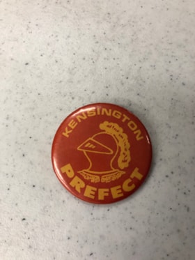
Button
https://search.heritageburnaby.ca/link/museumartifact90561
- Repository
- Burnaby Village Museum
- Accession Code
- BV020.33.4
- Description
- Red and Yellow button with a metal backing and pin fastener. A yellow image of a closed medival knight's helmet is in the centre of the button with "Kensington" (top) "Prefect" (bottom) around the image of the helmet.
- Object History
- From Kensington Junior Secondary SChool in the mid-1970s.
- Category
- 08. Communication Artifacts
- Classification
- Ceremonial Artifacts - - Organizational Objects
- Object Term
- Button, Promotional
- Colour
- Red
- Yellow
- Subjects
- Events - Competitions
- Sports
- Historic Neighbourhood
- Capitol Hill (Historic Neighbourhood)
- Planning Study Area
- Parkcrest-Aubrey Area
Images

Button
https://search.heritageburnaby.ca/link/museumartifact90562
- Repository
- Burnaby Village Museum
- Accession Code
- BV020.33.5
- Description
- Yellow and red button with a metal backing and pin fastener. A red image of a closed medival knight's helmet is in the centre of the button with "Kensington" (top) "Crusaders" (bottom) around the image of the helmet.
- Object History
- From Kensington Junior Secondary School in the mid-1970s.
- Category
- 08. Communication Artifacts
- Classification
- Ceremonial Artifacts - - Organizational Objects
- Object Term
- Button, Promotional
- Colour
- Yellow
- Red
- Subjects
- Events - Competitions
- Sports
- Historic Neighbourhood
- Capitol Hill (Historic Neighbourhood)
- Planning Study Area
- Parkcrest-Aubrey Area
Images
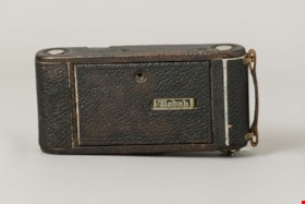
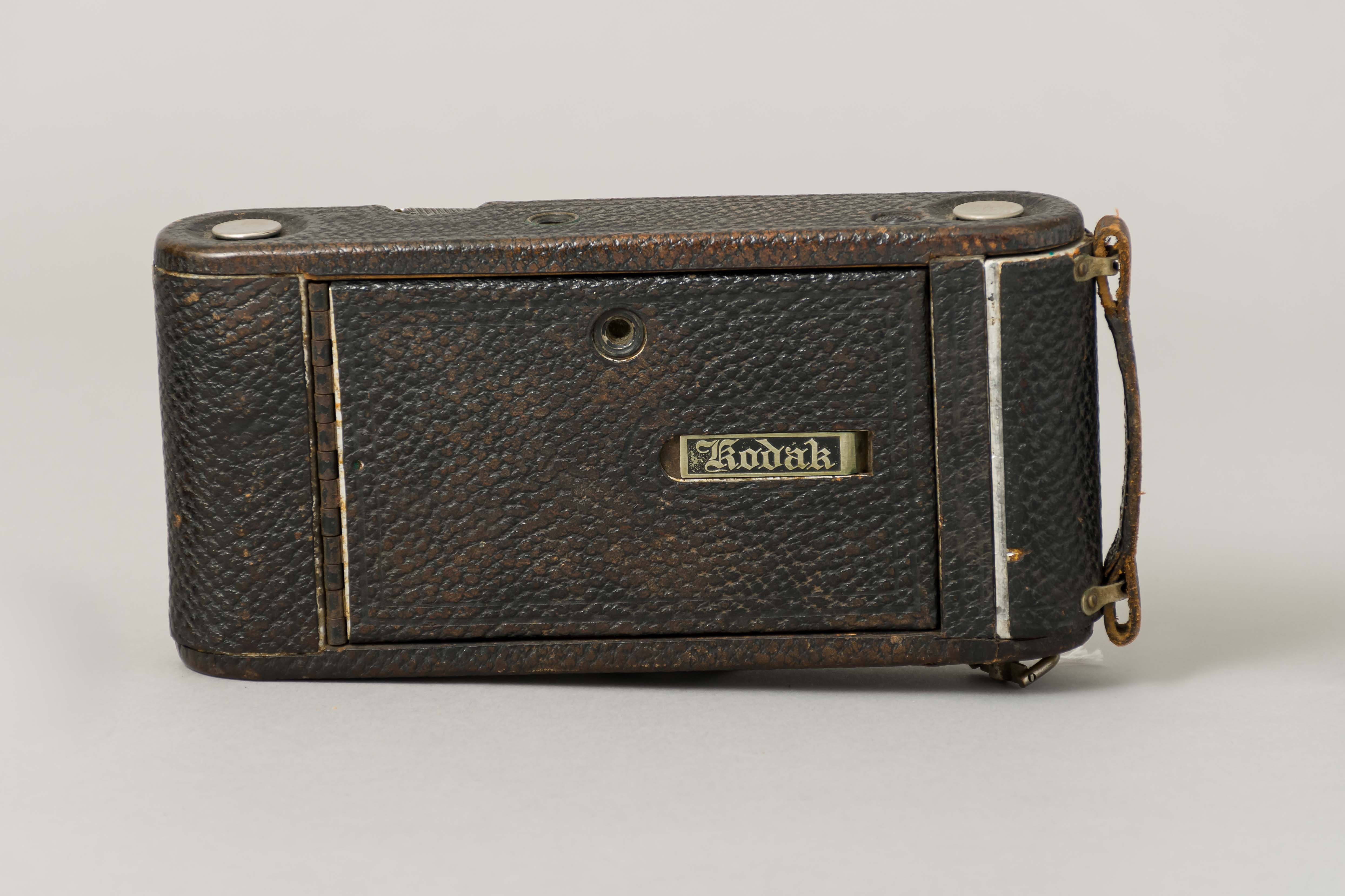
camera
https://search.heritageburnaby.ca/link/museumartifact358
- Repository
- Burnaby Village Museum
- Accession Code
- HV971.12.43
- Description
- Camera, Kodak Autographic No. 1-A Junior; missing a lens and autographic stylus
- Object History
- Object belonged to Alfred Bingham, an early Burnaby resident and activist.
- Classification
- Photographic T&E - - Camera Equipment
- Object Term
- Camera
- Subjects
- Communication Artifacts
- Names
- Bingham, Alfred "Alf"
- Historic Neighbourhood
- Lochdale (Historic Neighbourhood)
- Planning Study Area
- Willingdon Heights Area
- Parkcrest-Aubrey Area
Images

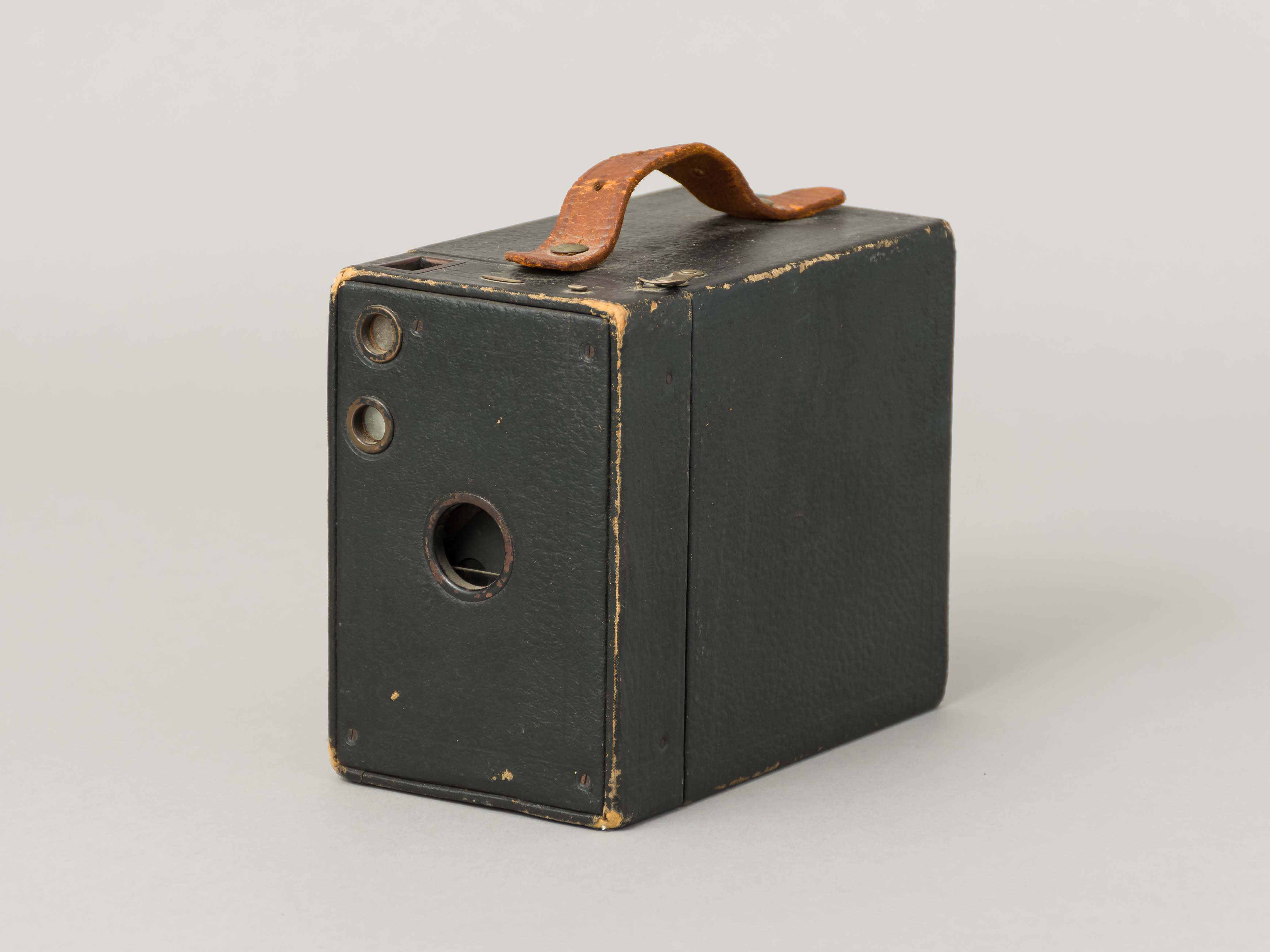
camera
https://search.heritageburnaby.ca/link/museumartifact420
- Repository
- Burnaby Village Museum
- Accession Code
- HV971.12.105
- Description
- Camera, black box type, textured; leather handle; no lens; back comes off; film spool holder attached to front part with lens, "No.2A BROWNIE CAMERA MODEL 8" "EASTMAN KODAK CO." "MANUFACTURED BY CANADIAN KODAK CO."; patent dates from 1897 to 1909; large
- Object History
- Object belonged to Alfred Bingham, an early Burnaby resident and activist.
- Classification
- Photographic T&E - - Camera Equipment
- Object Term
- Camera
- Marks/Labels
- No.2A BROWNIE CAMERA MODEL 8 / EASTMAN KODAK CO. / MANUFACTURED BY CANADIAN KODAK CO.
- Country Made
- Canada
- Province Made
- Ontario
- Site/City Made
- TORONTO
- Subjects
- Communication Artifacts
- Names
- Bingham, Alfred "Alf"
- Historic Neighbourhood
- Lochdale (Historic Neighbourhood)
- Planning Study Area
- Willingdon Heights Area
- Parkcrest-Aubrey Area
Images
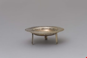
candleholder
https://search.heritageburnaby.ca/link/museumartifact329
- Repository
- Burnaby Village Museum
- Accession Code
- HV971.12.14
- Description
- Candle holder and stand
- Object History
- Object belonged to Alfred Bingham, an early Burnaby resident and activist.
- Category
- 02. Furnishings
- Classification
- Lighting Equipment - - Lighting Holders
- Object Term
- Candleholder
- Names
- Bingham, Alfred "Alf"
- Historic Neighbourhood
- Lochdale (Historic Neighbourhood)
- Planning Study Area
- Willingdon Heights Area
- Parkcrest-Aubrey Area
Images

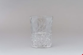
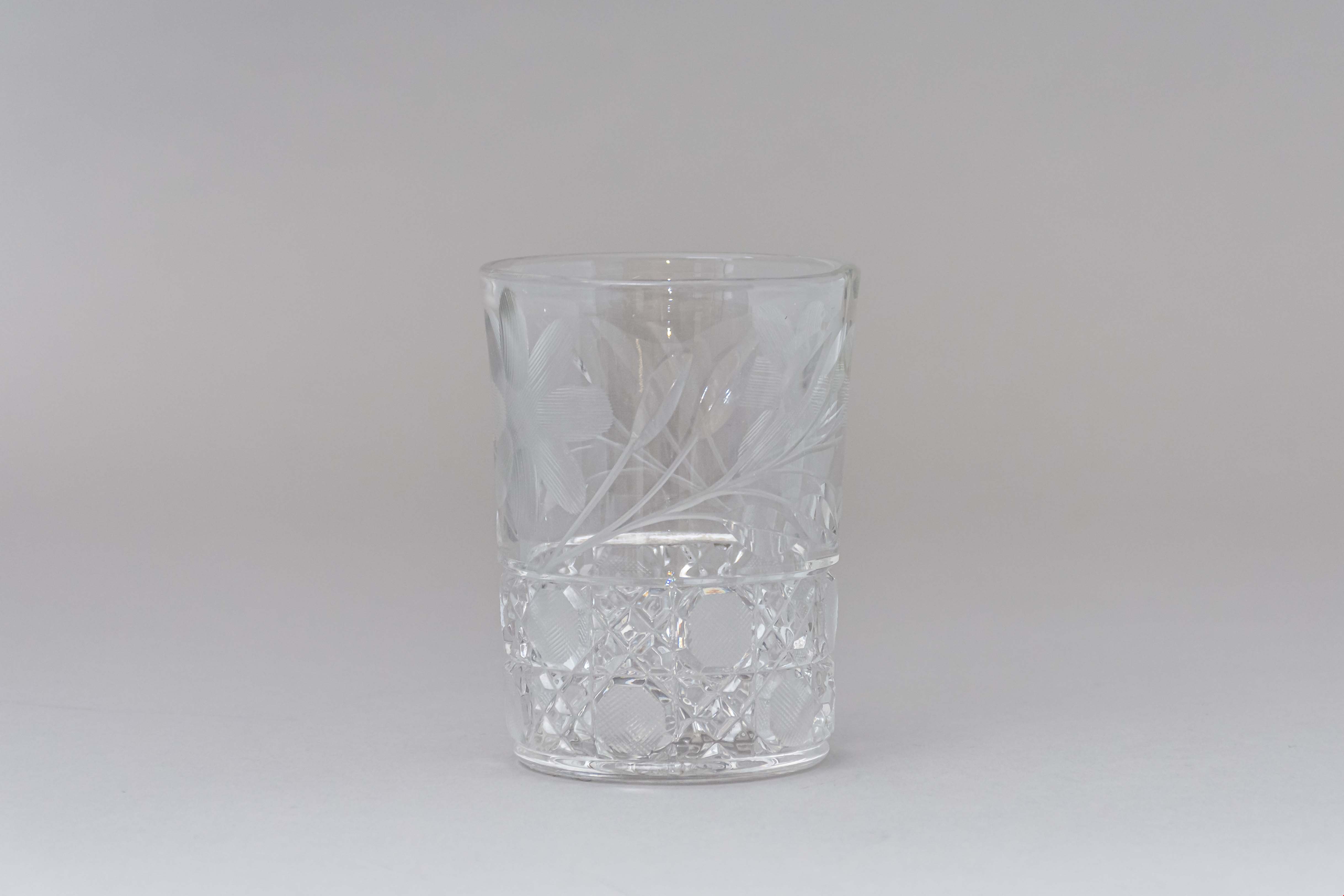
glass
https://search.heritageburnaby.ca/link/museumartifact362
- Repository
- Burnaby Village Museum
- Accession Code
- HV971.12.47
- Description
- Glass crystal, with cut pattern around base of alternating squares of diagonal lines and translucent cross-hatching; upper part of glass has design of flower with leaves, one on each side.
- Object History
- Object belonged to Alfred Bingham, an early Burnaby resident and activist.
- Category
- 04.Tools & Equipment for Materials
- Classification
- Food Service T&E - - Drinking Vessels
- Object Term
- Glass, Drinking
- Subjects
- Food Service Tools and Equipment
- Names
- Bingham, Alfred "Alf"
- Historic Neighbourhood
- Lochdale (Historic Neighbourhood)
- Planning Study Area
- Willingdon Heights Area
- Parkcrest-Aubrey Area
Images

Municipality of Burnaby - Volume XV and Volume XVIII
https://search.heritageburnaby.ca/link/museumdescription8680
- Repository
- Burnaby Village Museum
- Date
- May 1927
- Collection/Fonds
- Burnaby Village Museum Map collection
- Description Level
- File
- Physical Description
- 4 plans on 4 sheets : col. lithographic prints ; 63.5 x 53.5 cm folded to 53 x 31.5 cm
- Scope and Content
- File consists of four pages of plans removed from a bound book containing a series of fire insurance plans of the Municipality of Burnaby. The first two pages are numbered "A" and "B" and are key plans from "GREATER VANCOUVER B.C. / VOLUME XV / Surveyed _ May 1927 / MUNICIPALITY OF / BURNABY", "PLA…
- Repository
- Burnaby Village Museum
- Collection/Fonds
- Burnaby Village Museum Map collection
- Description Level
- File
- Physical Description
- 4 plans on 4 sheets : col. lithographic prints ; 63.5 x 53.5 cm folded to 53 x 31.5 cm
- Material Details
- Scales [1:1200] and [1:6000]
- Scope and Content
- File consists of four pages of plans removed from a bound book containing a series of fire insurance plans of the Municipality of Burnaby. The first two pages are numbered "A" and "B" and are key plans from "GREATER VANCOUVER B.C. / VOLUME XV / Surveyed _ May 1927 / MUNICIPALITY OF / BURNABY", "PLAN DEPT. FIRE BRANCH _ B.C. INSURANCE UNDERWRITERS ASSN.". Key Plan "B" covers plans: 1505; 1506; 1512 to 1516; 1540 to 1544; 1550 to 1557 and District Lots: 129 to 132; 135 to 138; 205 to 208 and 215 to 218. Key Plan "A" covers plans: 1501 to 1504; 1507 to 1511; 1517 to 1525; 1531 to 1539; 1545 to 1550 and District Lots: 116 to 127 and 186 to 189. Plan "1806" is part of "GREATER VANCOUVER B.C. / VOLUME XVIII / Municipality of Burnaby / May, 1927" and covers District Lot 153. Plan "1807" is from "GREATER VANCOUVER B.C. / VOLUME XVIII / Municipality of Burnaby / May, 1927" and covers District Lots: 99,149 and 152.
- Responsibility
- British Columbia Underwriters' Association
- Accession Code
- HV972.111.2
- Access Restriction
- No restrictions
- Reproduction Restriction
- May be restricted by third party rights
- Date
- May 1927
- Media Type
- Cartographic Material
- Historic Neighbourhood
- Vancouver Heights (Historic Neighbourhood)
- Lochdale (Historic Neighbourhood)
- Capitol Hill (Historic Neighbourhood)
- Central Park (Historic Neighbourhood)
- Alta Vista (Historic Neighbourhood)
- Planning Study Area
- Burnaby Heights Area
- Sperling-Broadway Area
- Lochdale Area
- Parkcrest-Aubrey Area
- Westridge Area
- Willingdon Heights Area
- Capitol Hill Area
- Maywood Area
- Marlborough Area
- Scan Resolution
- 400
- Scan Date
- 2021-11-18
- Notes
- Title based on content of plans
- Scales are measured 1 inch = 100 feet and 1 inch = 500 feet
- See also BV987.1.70d for revised versions of plans
Zoomable Images


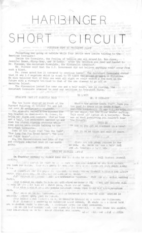
Newsletter
https://search.heritageburnaby.ca/link/museumartifact90969
- Repository
- Burnaby Village Museum
- Accession Code
- BV020.33.16
- Description
- Harbinger Short Circuit, school newsletter from Kensington Junior Secondary School - [196-]. Two pages of mimiographed legal sized cartridge paper; typewritten title on front page reads: HARBINGER / SHORT_CIRCUIT"; pages printed with black text on both sides.
- Object History
- From Kensington Junior Secondary School, Burnaby in the late 1960s.
- Category
- 08. Communication Artifacts
- Classification
- Documentary Artifacts - - Other Documents
- Object Term
- Serial
- Colour
- White
- Measurements
- 35.5 cm high x 25.5 cm
- Country Made
- Canada
- Province Made
- British Columbia
- Site/City Made
- Burnaby
- Subjects
- Documentary Artifacts - Newsletters
- Geographic Access
- Kensington Avenue
- Street Address
- 851 Kensington Avenue
- Historic Neighbourhood
- Capitol Hill (Historic Neighbourhood)
- Planning Study Area
- Parkcrest-Aubrey Area
Images

Newsletter
https://search.heritageburnaby.ca/link/museumartifact90970
- Repository
- Burnaby Village Museum
- Accession Code
- BV020.33.17
- Description
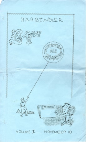
- Volume I, "Harbinger" school newsletter from Kensington Junior Secondary School - November 10 [196-]. Seven pages of mimiographed legal sized cartridge paper; printed both sides; front page printed on light blue cartridge paper with text at top "Harbinger and illustrations beneath; head of man wearing a tam and scarf and hand holding a coin with the word above "SAVE"; boy holding a circular balloon floating overhead with the words "ATTENTION / ALL / STUDENTS" and boy holding a newspaper with words "EXTRA" out in front while walking, text at bottom of front page reads:"VOLUME I NOVEMBER 10".
- Object History
- From Kensington Junior Secondary School, Burnaby in the late 1960s.
- Category
- 08. Communication Artifacts
- Classification
- Documentary Artifacts - - Other Documents
- Object Term
- Serial
- Colour
- Blue
- White
- Measurements
- 35.5 cm high x 25.5 cm
- Country Made
- Canada
- Province Made
- British Columbia
- Site/City Made
- Burnaby
- Subjects
- Documentary Artifacts - Newsletters
- Geographic Access
- Kensington Avenue
- Street Address
- 851 Kensington Avenue
- Historic Neighbourhood
- Capitol Hill (Historic Neighbourhood)
- Planning Study Area
- Parkcrest-Aubrey Area
Images

Newsletter
https://search.heritageburnaby.ca/link/museumartifact90971
- Repository
- Burnaby Village Museum
- Accession Code
- BV020.33.18
- Description
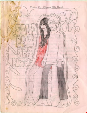
- Volume XII No. 3, "Harbinger" school newsletter from Kensington Junior Secondary School - March 14 [196-]. Seven pages of mimiographed letter sized cartridge paper; printed both sides; one page oversized paper; front page printed on light pink cartridge paper with text at top "March 14_Volume XII_No.3" and illustration of a side view of young man and woman standing together and bordered by flowing lines of spirals on either side and flower above, outlined graphic vertical text to the left of the couple reads "STUD/ENT/PRI/NTS" and "BEWARE THE IDES and exams!". Pink cartridge paper for back cover and white cartridge paper within. Front cover has been coloured in with red pencil crayon and pencil. Sixth page folds out and reveals a montage of photographs of students.
- Object History
- From Kensington Junior Secondary School, Burnaby in the late 1960s.
- Category
- 08. Communication Artifacts
- Classification
- Documentary Artifacts - - Other Documents
- Object Term
- Serial
- Marks/Labels
- Front and back covers have water stains.
- Colour
- Pink
- White
- Measurements
- 28 cm high x 21.5 cm wide
- Country Made
- Canada
- Province Made
- British Columbia
- Site/City Made
- Burnaby
- Subjects
- Documentary Artifacts - Newsletters
- Geographic Access
- Kensington Avenue
- Street Address
- 851 Kensington Avenue
- Historic Neighbourhood
- Capitol Hill (Historic Neighbourhood)
- Planning Study Area
- Parkcrest-Aubrey Area
Images

Newsletter
https://search.heritageburnaby.ca/link/museumartifact90972
- Repository
- Burnaby Village Museum
- Accession Code
- BV020.33.19
- Description
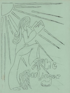
- Harbinger school newsletter from Kensington Junior Secondary School - [196-]. Six pages of mimiographed cartridge paper; five pages printed both sides; one page oversized paper; front cover page printed on light green cartridge paper with illustration of a woman with long hair and bell bottom pants holding a book and standing with her right foot on the letter "T" in the title "The / Harbinger" with rays of sunshine projected diagonally from the top left corner of the page. Yellow cartridge paper back cover and white cartridge paper within numbered 1 to 10. Paper between pages 6 and 7 folds out and reveals a montage of photographs of students.
- Object History
- From Kensington Junior Secondary School, Burnaby in the late 1960s.
- Category
- 08. Communication Artifacts
- Classification
- Documentary Artifacts - - Other Documents
- Object Term
- Serial
- Colour
- Green
- White
- Yellow
- Measurements
- 28 cm high x 21.5 cm wide
- Country Made
- Canada
- Province Made
- British Columbia
- Site/City Made
- Burnaby
- Subjects
- Documentary Artifacts - Newsletters
- Geographic Access
- Kensington Avenue
- Street Address
- 851 Kensington Avenue
- Historic Neighbourhood
- Capitol Hill (Historic Neighbourhood)
- Planning Study Area
- Parkcrest-Aubrey Area
Images

Newsletter
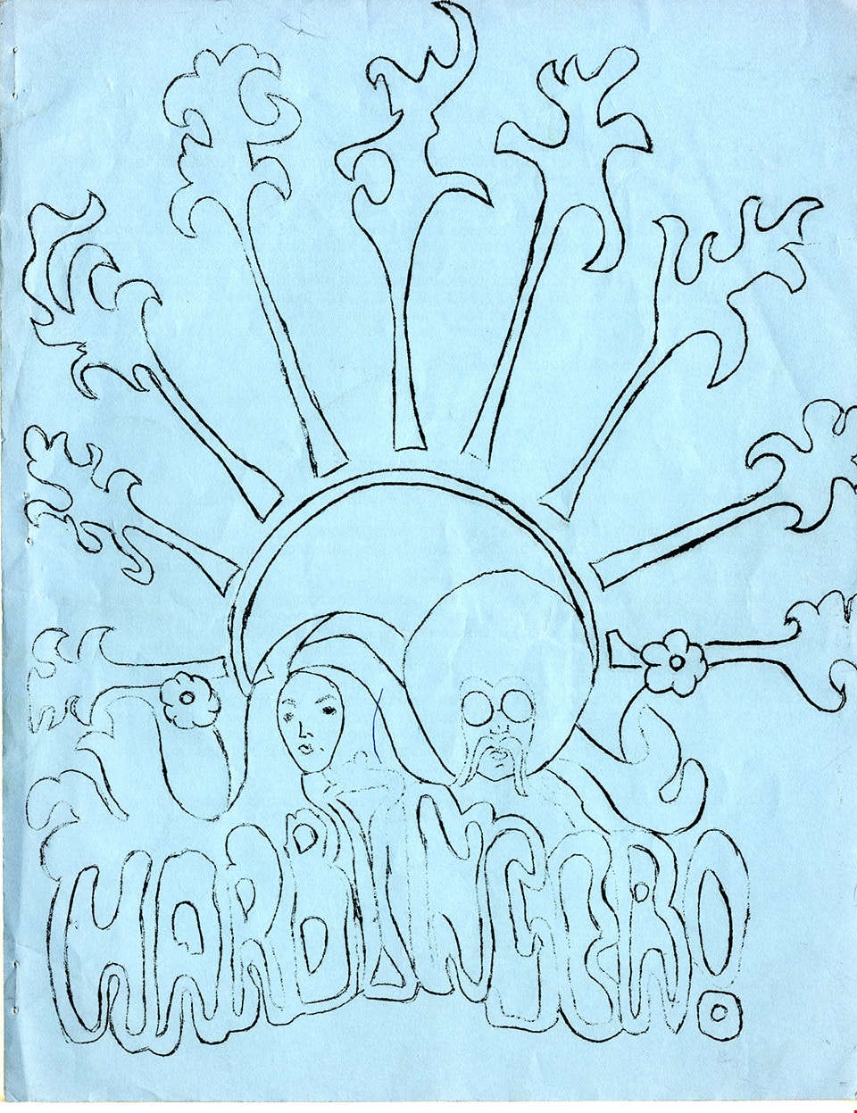
https://search.heritageburnaby.ca/link/museumartifact90973
- Repository
- Burnaby Village Museum
- Accession Code
- BV020.33.20
- Description
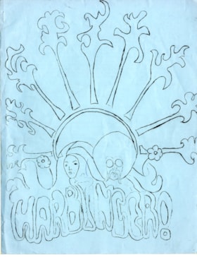
- Harbinger school newsletter from Kensington Junior Secondary School - March [196-]. Nine pages of mimiographed cartridge paper; seven pages printed both sides; one page oversized paper; front cover page printed on light blue cartridge paper with illustration of a man's head with an afro and mustache and woman's head with long flowing hair nestled in a stylized sunburst that radiates to the top of the page with the stylized word "HARBINGER!" at the bottom. Blue cartridge paper back cover and white cartridge paper within numbered 1 to 14. Paper between pages 8 and 9 folds out and reveals a montage of photographs of students. Water staining on front cover page.
- Object History
- From Kensington Junior Secondary School, Burnaby in the late 1960s.
- Category
- 08. Communication Artifacts
- Classification
- Documentary Artifacts - - Other Documents
- Object Term
- Serial
- Colour
- Blue
- White
- Measurements
- 28 cm high x 21.5 cm wide
- Country Made
- Canada
- Province Made
- British Columbia
- Site/City Made
- Burnaby
- Subjects
- Documentary Artifacts - Newsletters
- Geographic Access
- Kensington Avenue
- Street Address
- 851 Kensington Avenue
- Historic Neighbourhood
- Capitol Hill (Historic Neighbourhood)
- Planning Study Area
- Parkcrest-Aubrey Area
Images
Newsletter
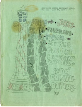
https://search.heritageburnaby.ca/link/museumartifact90974
- Repository
- Burnaby Village Museum
- Accession Code
- BV020.33.21
- Description
- Kensington Junior Secondary School newsletter - June 11, 1968. Sixteen pages of mimiographed cartridge paper; fifteen pages printed both sides; one page oversized paper; pages numbered 1-29; pages 12-13 and 28-29 printed on light pink cartridge paper. Front cover page printed on light green cartridge paper with typewritten text in upper right corner "KENSINGTON JUNIOR SECONDARY SCHOOL / VOL. XIII : June 11, 1968 : No. 4" and illustration of a roman column to the left with words at base of column "LOOK .IN" and stylized vertical lettering to the right "STUDENT / PRINTS" and horizontal lettering "WITH (arrow to right) . JOKES . / . PICTURES. / . POEMS . / . STORIES . / FOR . THE / LITERARY / CONTEST . / and / CORNU- / COPIUS / CR [sic]". Front cover has been coloured with blue and red pen. Oversized page between pages 25 and 26 folds out and reveals a montage of photographs of students and teachers.
- Object History
- From Kensington Junior Secondary School, Burnaby in 1968.
- Category
- 08. Communication Artifacts
- Classification
- Documentary Artifacts - - Other Documents
- Object Term
- Serial
- Marks/Labels
- water/oil staining on cover page
- Colour
- Green
- Pink
- White
- Measurements
- 28 cm high x 21.5 cm wide
- Country Made
- Canada
- Province Made
- British Columbia
- Site/City Made
- Burnaby
- Subjects
- Documentary Artifacts - Newsletters
- Geographic Access
- Kensington Avenue
- Street Address
- 851 Kensington Avenue
- Historic Neighbourhood
- Capitol Hill (Historic Neighbourhood)
- Planning Study Area
- Parkcrest-Aubrey Area
Images
