Narrow Results By
Decade
- 2020s 15
- 2010s 28
- 2000s 116
- 1990s
- 1980s 98
- 1970s 150
- 1960s 125
- 1950s 177
- 1940s 143
- 1930s 193
- 1920s 389
- 1910s 305
- 1900s 171
- 1890s 98
- 1880s
- 1870s 10
- 1860s 13
- 1850s 6
- 1840s 1
- 1810s 1
- 1800s 1
- 1790s 1
- 1780s 1
- 1770s 1
- 1760s 1
- 1750s 1
- 1740s 1
- 1730s 1
- 1720s 1
- 1710s 1
- 1700s 1
- 1690s 1
- 1680s 1
- 1670s 1
- 1660s 1
- 1650s 1
- 1640s 1
- 1630s 1
- 1620s 1
- 1610s 1
- 1600s 1
- 1590s 1
- 1580s 1
- 1570s 1
- 1560s 1
- 1550s 1
- 1540s 1
- 1530s 1
- 1520s 1
- 1510s 1
- 1500s 1
- 1490s 1
- 1480s 1
Subject
- Accidents - Automobile Accidents 1
- Agriculture 1
- Agriculture - Farms 3
- Animals - Dogs 1
- Arts 6
- Buildings - Civic 2
- Buildings - Civic - Archives 1
- Buildings - Civic - Museums 1
- Buildings - Commercial - Grocery Stores 1
- Buildings - Commercial - Restaurants 1
- Buildings - Commercial - Stores 1
- Buildings - Recreational 2
20th Street in New Westminster
https://search.heritageburnaby.ca/link/councilreport5768
- Repository
- City of Burnaby Archives
- Report ID
- 61367
- Meeting Date
- 6-Apr-1998
- Format
- Council - Manager's Report
- Manager's Report No.
- 10
- Item No.
- 8
- Collection/Fonds
- City Council and Office of the City Clerk fonds
- Repository
- City of Burnaby Archives
- Report ID
- 61367
- Meeting Date
- 6-Apr-1998
- Format
- Council - Manager's Report
- Manager's Report No.
- 10
- Item No.
- 8
- Collection/Fonds
- City Council and Office of the City Clerk fonds
Documents
20th Street Truck Route Declassification by New Westminster with the Ministry of Transportation and Highways Officials at Union of BC Municipalities
https://search.heritageburnaby.ca/link/councilreport5445
- Repository
- City of Burnaby Archives
- Report ID
- 61699
- Meeting Date
- 14-Sep-1998
- Format
- Council - Committee Report
- Collection/Fonds
- City Council and Office of the City Clerk fonds
- Repository
- City of Burnaby Archives
- Report ID
- 61699
- Meeting Date
- 14-Sep-1998
- Format
- Council - Committee Report
- Collection/Fonds
- City Council and Office of the City Clerk fonds
Documents
Bylaw Number: 9624 - New Westminster Agreement Ratification Bylaw 1991
https://search.heritageburnaby.ca/link/bylaw14755
- Repository
- Legislative Services
- Bylaw Number
- 9624
- Final Adoption
- 1991 Nov 12
- Format
- Bylaws - Adopted
- Collection/Fonds
- City Council and Office of the City Clerk fonds
- Repository
- Legislative Services
- Bylaw Number
- 9624
- Final Adoption
- 1991 Nov 12
- Format
- Bylaws - Adopted
- Collection/Fonds
- City Council and Office of the City Clerk fonds
Documents
City of New Westminster Official Community Plan
https://search.heritageburnaby.ca/link/councilreport5909
- Repository
- City of Burnaby Archives
- Report ID
- 61233
- Meeting Date
- 26-Jan-1998
- Format
- Council - Manager's Report
- Manager's Report No.
- 3
- Item No.
- 2
- Collection/Fonds
- City Council and Office of the City Clerk fonds
- Repository
- City of Burnaby Archives
- Report ID
- 61233
- Meeting Date
- 26-Jan-1998
- Format
- Council - Manager's Report
- Manager's Report No.
- 3
- Item No.
- 2
- Collection/Fonds
- City Council and Office of the City Clerk fonds
Documents

Downtown New Westminster
https://search.heritageburnaby.ca/link/archivedescription78687
- Repository
- City of Burnaby Archives
- Date
- November 12, 1995
- Collection/Fonds
- Burnaby NewsLeader photograph collection
- Description Level
- Item
- Physical Description
- 1 photograph : b&w ; 15 x 22 cm
- Scope and Content
- Photograph of a street view of New Westminster's downtown.
- Repository
- City of Burnaby Archives
- Date
- November 12, 1995
- Collection/Fonds
- Burnaby NewsLeader photograph collection
- Physical Description
- 1 photograph : b&w ; 15 x 22 cm
- Description Level
- Item
- Record No.
- 535-0048
- Access Restriction
- No restrictions
- Reproduction Restriction
- No reproduction permitted
- Accession Number
- 2012-11
- Scope and Content
- Photograph of a street view of New Westminster's downtown.
- Media Type
- Photograph
- Photographer
- Bartel, Mario
- Notes
- Title based on contents of photograph
- Note in black ink on recto of photograph reads: "11/12 Bby p.1 118% Mario NW 2941 D"
- Trim marks and/or reproduction instructions on recto (scan is cropped)
Images

Draft Queensborough Official Community Plan City of New Westminster Official Community Plan Designation Bylaw No. 6219, 1994
https://search.heritageburnaby.ca/link/councilreport8407
- Repository
- City of Burnaby Archives
- Report ID
- 4805
- Meeting Date
- 24-Oct-1994
- Format
- Council - Manager's Report
- Manager's Report No.
- 60
- Item No.
- 9
- Collection/Fonds
- City Council and Office of the City Clerk fonds
- Repository
- City of Burnaby Archives
- Report ID
- 4805
- Meeting Date
- 24-Oct-1994
- Format
- Council - Manager's Report
- Manager's Report No.
- 60
- Item No.
- 9
- Collection/Fonds
- City Council and Office of the City Clerk fonds
Documents
Draft Queensborough Official Community Plan, Corporation of the City of New Westminster
https://search.heritageburnaby.ca/link/councilreport7896
- Repository
- City of Burnaby Archives
- Report ID
- 5278
- Meeting Date
- 5-Jun-1995
- Format
- Council - Manager's Report
- Manager's Report No.
- 27
- Item No.
- 15
- Collection/Fonds
- City Council and Office of the City Clerk fonds
- Repository
- City of Burnaby Archives
- Report ID
- 5278
- Meeting Date
- 5-Jun-1995
- Format
- Council - Manager's Report
- Manager's Report No.
- 27
- Item No.
- 15
- Collection/Fonds
- City Council and Office of the City Clerk fonds
Documents
Marine/10th Connector : Proposed Joint Resolution Presented by New Westminster Council
https://search.heritageburnaby.ca/link/councilreport7261
- Repository
- City of Burnaby Archives
- Report ID
- 25575
- Meeting Date
- 15-Apr-1996
- Format
- Council - Committee Report
- Collection/Fonds
- City Council and Office of the City Clerk fonds
- Repository
- City of Burnaby Archives
- Report ID
- 25575
- Meeting Date
- 15-Apr-1996
- Format
- Council - Committee Report
- Collection/Fonds
- City Council and Office of the City Clerk fonds
Documents
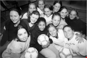
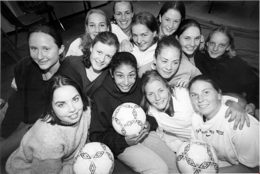
New Westminster Hyacks girls soccer team
https://search.heritageburnaby.ca/link/archivedescription80454
- Repository
- City of Burnaby Archives
- Date
- June 4, 1997
- Collection/Fonds
- Burnaby NewsLeader photograph collection
- Description Level
- Item
- Physical Description
- 1 photograph : b&w ; 15.5 x 22.5 cm
- Scope and Content
- Photograph of New Westminster Hyacks girls soccer team. Back row, left to right: Lisa Vissar, Heather Mackerricjer, Catherine Ducheminski, unidentified girl, Alison Spence, Leah Neilson. Middle: Julie Gilmour, Angela Smith, unidentified girl. Front: Kim Duffy, Kim Niezner, Miranda Zilm, Christy Tre…
- Repository
- City of Burnaby Archives
- Date
- June 4, 1997
- Collection/Fonds
- Burnaby NewsLeader photograph collection
- Physical Description
- 1 photograph : b&w ; 15.5 x 22.5 cm
- Description Level
- Item
- Record No.
- 535-0771
- Access Restriction
- No restrictions
- Reproduction Restriction
- No reproduction permitted
- Accession Number
- 2012-11
- Scope and Content
- Photograph of New Westminster Hyacks girls soccer team. Back row, left to right: Lisa Vissar, Heather Mackerricjer, Catherine Ducheminski, unidentified girl, Alison Spence, Leah Neilson. Middle: Julie Gilmour, Angela Smith, unidentified girl. Front: Kim Duffy, Kim Niezner, Miranda Zilm, Christy Treslove.
- Names
- Vissar, Lisa
- Mackerricjer, Heather
- Ducheminski, Catherine
- Spence, Alison
- Neilson, Leah
- Gilmour, Julie
- Smith, Angela
- Duffy, Kim
- Neizner, Kim
- Zilm, Miranda
- Treslove, Christy
- Media Type
- Photograph
- Photographer
- Langdeau, Brian
- Notes
- Title based on contents of photograph
- Note in black ink on recto of photograph reads: "Bby/ Brian 1282 B 43% Bby p 17"
- Trim marks and/or reproduction instructions on recto (scan is cropped)
Images
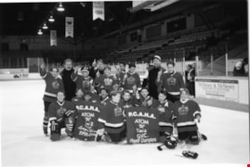
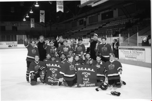
New Westminster Red Devils Atom Hockey Team
https://search.heritageburnaby.ca/link/archivedescription79076
- Repository
- City of Burnaby Archives
- Date
- April 10, 1996
- Collection/Fonds
- Burnaby NewsLeader photograph collection
- Description Level
- Item
- Physical Description
- 1 photograph : col. ; 10 x 15 cm
- Scope and Content
- Photograph of the New Westminster Red Devils atom hockey team after winning the Atom Tier 2 Championship.
- Repository
- City of Burnaby Archives
- Date
- April 10, 1996
- Collection/Fonds
- Burnaby NewsLeader photograph collection
- Physical Description
- 1 photograph : col. ; 10 x 15 cm
- Description Level
- Item
- Record No.
- 535-0253
- Access Restriction
- No restrictions
- Reproduction Restriction
- No reproduction permitted
- Accession Number
- 2012-11
- Scope and Content
- Photograph of the New Westminster Red Devils atom hockey team after winning the Atom Tier 2 Championship.
- Subjects
- Sports - Ice Hockey
- Media Type
- Photograph
- Notes
- Title based on contents of photograph
Images
Proposed Gaming Facility in New Westminster
https://search.heritageburnaby.ca/link/councilreport5979
- Repository
- City of Burnaby Archives
- Report ID
- 61164
- Meeting Date
- 8-Dec-1997
- Format
- Council - Manager's Report
- Manager's Report No.
- 32
- Item No.
- 6
- Collection/Fonds
- City Council and Office of the City Clerk fonds
- Repository
- City of Burnaby Archives
- Report ID
- 61164
- Meeting Date
- 8-Dec-1997
- Format
- Council - Manager's Report
- Manager's Report No.
- 32
- Item No.
- 6
- Collection/Fonds
- City Council and Office of the City Clerk fonds
Documents
Recent Transit Service Reductions on #106 New Westminster Station/Metrotown Station Bus Route Serving Kingsway Corridor East of Metrotown
https://search.heritageburnaby.ca/link/councilreport8701
- Repository
- City of Burnaby Archives
- Report ID
- 13056
- Meeting Date
- 13-Jun-1994
- Format
- Council - Committee Report
- Collection/Fonds
- City Council and Office of the City Clerk fonds
- Repository
- City of Burnaby Archives
- Report ID
- 13056
- Meeting Date
- 13-Jun-1994
- Format
- Council - Committee Report
- Collection/Fonds
- City Council and Office of the City Clerk fonds
Documents
Road Conditions on Marine Drive from Royal Oak Avenue West to New Westminster
https://search.heritageburnaby.ca/link/councilreport7203
- Repository
- City of Burnaby Archives
- Report ID
- 25591
- Meeting Date
- 6-May-1996
- Format
- Council - Committee Report
- Collection/Fonds
- City Council and Office of the City Clerk fonds
- Repository
- City of Burnaby Archives
- Report ID
- 25591
- Meeting Date
- 6-May-1996
- Format
- Council - Committee Report
- Collection/Fonds
- City Council and Office of the City Clerk fonds
Documents
Sale of Municipal Property Lots 103, 104 and 107 DL 13, Group 1, New Westminster District, Plan 8124 Lots A-G, DL 13, Group 1, NWD Plan unregistered Cariboo Heights Subdivision - Area 1
https://search.heritageburnaby.ca/link/councilreport12001
- Repository
- City of Burnaby Archives
- Report ID
- 8487
- Meeting Date
- 14-May-1990
- Format
- Council - Manager's Report
- Manager's Report No.
- 35
- Item No.
- 7
- Collection/Fonds
- City Council and Office of the City Clerk fonds
- Repository
- City of Burnaby Archives
- Report ID
- 8487
- Meeting Date
- 14-May-1990
- Format
- Council - Manager's Report
- Manager's Report No.
- 35
- Item No.
- 7
- Collection/Fonds
- City Council and Office of the City Clerk fonds
Documents
![Subdivision plans in New Westminster District Group 1 – Burnaby
, [1882-1910] thumbnail](/media/hpo/_Data/_BVM_Cartographic_Material/1977/1977_0093_0013a_001.jpg?width=280)
Subdivision plans in New Westminster District Group 1 – Burnaby
https://search.heritageburnaby.ca/link/museumdescription6982
- Repository
- Burnaby Village Museum
- Date
- [1882-1910]
- Collection/Fonds
- Burnaby Village Museum Map collection
- Description Level
- File
- Physical Description
- 4 plans : blueprint on paper mounted on 2 sides of cardboard 76 x 102 cm
- Scope and Content
- Item consists of a large board of two New Westminster District Gp 1 - subdivision plans mounted on one side and two New Westminster District Gp 1 - subdivision plans mounted on the other side. Side A: 1. Blueprint "Plan / of the / Subdivision / of / Lot 98 / G.1, N.W.D. / Scale 4 chs = 1 in. / …
- Repository
- Burnaby Village Museum
- Collection/Fonds
- Burnaby Village Museum Map collection
- Description Level
- File
- Physical Description
- 4 plans : blueprint on paper mounted on 2 sides of cardboard 76 x 102 cm
- Material Details
- Scales [between 1:1584 and 1:3168]
- Index number on edge of board reads: "13"
- Scope and Content
- Item consists of a large board of two New Westminster District Gp 1 - subdivision plans mounted on one side and two New Westminster District Gp 1 - subdivision plans mounted on the other side. Side A: 1. Blueprint "Plan / of the / Subdivision / of / Lot 98 / G.1, N.W.D. / Scale 4 chs = 1 in. / Map No 573" (Geographic location: Burnaby) 2. Blueprint "Plan / of Subdivision of / Lot 157 / Gr.1, New. West. Dist. / Scale 3 chs = 1 in. / Map No. 612". (Geographic location: Burnaby) Side B: 1. Blueprint "Plan / of Subdivision / of a Portion of / Lot 90 / Group One / New Westminster Dist. / Scale 2 chs = 1 in. / Map No. 555". Plan is signed by "Jno Strathern [sic]_P.L.S."n (Geographic location: Burnaby) 2. Blueprint "Subdivision of Lot 31, Group 1. / New Westminster District / As Amended by Order of Court / 1st Sept. 1882 and Numbered 847 / Scale 4 chs = 1in. / Map No 80" (Geographic location: Burnaby)
- Creator
- Stathern, John
- Accession Code
- HV977.93.13
- Access Restriction
- No restrictions
- Reproduction Restriction
- No known restrictions
- Date
- [1882-1910]
- Media Type
- Cartographic Material
- Historic Neighbourhood
- Alta Vista (Historic Neighbourhood)
- Planning Study Area
- Richmond Park Area
- Lakeview-Mayfield Area
- Scan Resolution
- 300
- Scale
- 72
- Notes
- Title based on contents of file
- Scale is measured in chains. (One chain equals 792 inches)
- The term "Lot" can also refer to a "District Lot”
Images
![Subdivision plans in New Westminster District Group 1 – Burnaby
, [1882-1910] thumbnail](/media/hpo/_Data/_BVM_Cartographic_Material/1977/1977_0093_0013a_001.jpg)

![Survey and Subdivision plans in New Westminster District Group 1 – Burnaby
, [1861]-[1910] thumbnail](/media/hpo/_Data/_BVM_Cartographic_Material/1977/1977_0093_0019a_001.jpg?width=280)
Survey and Subdivision plans in New Westminster District Group 1 – Burnaby
https://search.heritageburnaby.ca/link/museumdescription6988
- Repository
- Burnaby Village Museum
- Date
- [1861]-[1910]
- Collection/Fonds
- Burnaby Village Museum Map collection
- Description Level
- File
- Physical Description
- 14 plans : 3 plans : black ink on paper hand col. + 7 plans : black ink on paper + 4 plans : graphite on paper mounted on 2 sides of cardboard 76 x 102 cm
- Scope and Content
- Item consists of a large board of four New Westminster District Gp 1 - subdivision plans mounted on one side and ten New Westminster District Gp 1 - subdivision plans mounted on the other side. Side A: 1. "Plan /of / Lots 166A, 166 and 167 /, Gr.1, N.W.D. / Showing Misconstructed Roads in Gree…
- Repository
- Burnaby Village Museum
- Collection/Fonds
- Burnaby Village Museum Map collection
- Description Level
- File
- Physical Description
- 14 plans : 3 plans : black ink on paper hand col. + 7 plans : black ink on paper + 4 plans : graphite on paper mounted on 2 sides of cardboard 76 x 102 cm
- Material Details
- Scales [between 1:2376 and 1:7920]
- Index number on edge of board reads: "19"
- Scope and Content
- Item consists of a large board of four New Westminster District Gp 1 - subdivision plans mounted on one side and ten New Westminster District Gp 1 - subdivision plans mounted on the other side. Side A: 1. "Plan /of / Lots 166A, 166 and 167 /, Gr.1, N.W.D. / Showing Misconstructed Roads in Green / 5 chs = 1 in.". (plan is drawn in black ink and hand coloured in red, green and orange ink). A section in the centre of the plan is coloured in red ink and identified as "C.S. Richmond" running from the North Arm of Fraser River to Wiggins Road and divided by "New Wiggins Rd. (as gazetted)" (coloured in orange ink) and two"Constructed Road(s)" (coloured in green ink). Plan is initialed by: "RB" [sic] (in blue pencil crayon) 2. Plan of / Subdivision of / Lot 166 / Group One / New Westminster District / Scale 4 chs = 1 in. / Map No 524". Plan is drawn in graphite and signed by "Surrig [sic] Welhams [sic] / P.L.S." Plan is initialed by: "RB" [sic] (in blue pencil crayon) 3. Plan of "Survey / of Highway / For / Burnaby Council / in / Lots 13 _14 / Group One / Scale 4 chs = 1 in." Signed by "Albert J. Hill, P.L.S." Caribou Street and Caribou Road run through the centre of the plan. Plan is stamped: "Albert J. Hill, Civil Engineer / and / Provincial Land Surveyor, / New Westminster, / B.C.". Plan is initialed by: "RB" [sic] (in blue pencil crayon) 4. A Plan of Lots 166A, 166 and 167, Group One, New Westminster District (drawn in graphite). A section in the centre of the plan is identified as "C.S. Richmond" running from the North Arm of Fraser River and divided by "New Wiggins Rd. (as gazetted)" and two "Constructed Road(s)". Plan is initialed by: "RB" [sic] (in blue pencil crayon) Side B: 1. Small plan drawn in black ink (no title) identifying lots north of the "North Arm" of the Fraser River. Lots identified include: Lot 99, Lot 98, Lot 157, Lot 158, Lot 163, Lot 162, Lot 159, Lot 163, Lot 162, Lot 165, Lot 166A, Lot 155B, Lot 155A and Lot 159. "Scale 40 chains to one inch" . Plan is initialed by: "RB" [sic] (in blue pencil crayon) (Geographic location: Burnaby) 2. Small plan drawn in black ink (no title) identifying lots north of the North Arm of the Fraser River as "Lots 155, 155A, 155B, 155C, 162, 163, 164, 165, 166A and 167". Plan is initialed by: "RB" [sic] (in blue pencil crayon) (Geographic location: Burnaby) 3. Small plan drawn in black ink (no title) which identifies "Lot 151 / Reserve/ for / Race Course"; "Reserve / 64 A / L. 152 G.1"; and other Lots: 32, 33, 34, 35, 36, 38, 39. The plan is signed "Surveyor G.Turn [sic] July / 61 / from Vol 40 R.L. notes [sic]" Plan is stamped: "Albert J. Hill, Civil Engineer / and / Provincial Land Surveyor, / New Westminster, / B.C." Plan is initialed by: "RB" [sic] (in blue pencil crayon) (Geographic location: Burnaby) 4. Small plan drawn in black in with faded red colouring on centre lot identified as "Lot 34" running north from "Vancouver Road" . Plan is stamped: "Albert J. Hill, Civil Engineer / and / Provincial Land Surveyor, / New Westminster, / B.C." Plan is initialed by: "RB" [sic] (in blue pencil crayon) (Geographic location: Burnaby) 5. Plan drawn in graphite and identified as "Lot 98, Gr.1," along with the intials "RB" [sic] (both are handwritten in blue crayon pencil on top of plan) The B.C.E.Railway is identified running through the plan along with Jubilee Road and Royal Oak Road. The plan is signed with the name "Wm. Murray" and the Plan is stamped: "Albert J. Hill, Civil Engineer / and / Provincial Land Surveyor, / New Westminster, / B.C.". (Geographic location: Burnaby) 6. Plan drawn in graphite identified as "Port Lot 13, Gr.1" along with the intials "RB" [sic] (both are handwritten in blue crayon pencil on top of plan) Plan is stamped: "Albert J. Hill, Civil Engineer / and / Provincial Land Surveyor, / New Westminster, / B.C.". (Geographic location: Burnaby) 7.Plan drawn in black ink and identified as "Lot 98 G.1" along with the intials "RB" [sic] (both are handwritten in blue crayon pencil on top of plan). A "Road Reservation" is identified running north between "Electric Tramway" and connecting with "Royal Oak Road". Plan is stamped: "Albert J. Hill, Civil Engineer / and / Provincial Land Surveyor, / New Westminster, / B.C." (Geographic location: Burnaby) 8. Plan drawn in black ink and divided into two sections, the upper plan is identified as "Portion / Lots 100 / area / 101, Gr.1" and the lower plan is identified as "Portion L. 3 G. 1" along with the intials "RB" [sic] (these identifiers are handwritten in blue crayon pencil on top of the plan). Portions of Lot 100 and Lot 101 are each divided into 6 sections and the Portion of Lot 3 plan is divided into 24 sections. The plan includes a note in black ink that reads: " Received from Wm Fromme [sic] / from Wm. Trapp / Nov. 28, 1895 / A. J. T...[sic]". (Geographic location: Burnaby) 9. Plan drawn in black ink (no title) identifying soil, buildings and geographic features in southern Burnaby. The plan is bordered by "New Westminster City" (Tenth Avenue and DL 172) to the south east and DL 173 to the south, DL 158 to the west and the B.C.E. Tramway to the north. Plan includes District Lots: 155A, 158, 159, 171, 160, 53 and 95 and identifies soil, marshland and ravines throughout. Plan identifies the following features: a "Team Road" running through Lots 158 and 159 along with "Fair Orchard Soil / Even Surface Throughout / No Ravines", "Gravel and Shingle" (bottom of Lot 158), "North Arm Road" crossing "Byrne Road" and connecting with "Power House Road" which runs north to connect with "Highland Park Station" and the B.C.E. Tramway, "Power Ho" in the northeast corner of DL 160, a "Brook" connected with a "Deep Ravine" running between DL 53, DL 95 and DL 160 along with "Good Soil" and "Fair Orchard Soil" identified nearby in DL 95. Scale is identified as "10 chs = 1 in." Plan is stamped: "Albert J. Hill, Civil Engineer / and / Provincial Land Surveyor, / New Westminster, / B.C." Plan is initialed by: "RB" [sic] (in blue pencil crayon) (Geographic location: Burnaby) 10. Plan drawn in black ink (no title) with Burnaby Lake and Deer Lake at the centre. The plan is bordered by the following District Lots identified as: 117, 118 and 68 to the west, Lots 80, 79 and 85 to the southwest, Lots 11, 13, and 1 (City of New Westminster) to the south east, the North Road boundary to the east and Lots 8, 56, 57, 59, and 136 to the North. The lower right hand corner of the plan has a small inset which reads: "Burnaby Lake" and "Page 19 R.B. Notes". Plan is initialed by: "RB" [sic] (in blue pencil crayon) (Geographic location: Burnaby)
- Creator
- Hill, Albert James
- Accession Code
- HV977.93.19
- Access Restriction
- No restrictions
- Reproduction Restriction
- No known restrictions
- Date
- [1861]-[1910]
- Media Type
- Cartographic Material
- Scan Resolution
- 300
- Scale
- 72
- Notes
- Title based on contents of file
- Scale is measured in chains. (One chain equals 792 inches)
- The term "Lot" can also refer to a "District Lot”
- Some plans are stamped: "Albert J. Hill, Civil Engineer / and / Provincial Land Surveyor, / New Westminster, / B.C." and intialed: "RB" [sic]
Images
![Survey and Subdivision plans in New Westminster District Group 1 – Burnaby
, [1861]-[1910] thumbnail](/media/hpo/_Data/_BVM_Cartographic_Material/1977/1977_0093_0019a_001.jpg)

![Survey and Subdivision plans in New Westminster District Group 1 – Burnaby, Port Moody, [1862-1908] thumbnail](/media/hpo/_Data/_BVM_Cartographic_Material/1977/1977_0093_0026a_001.jpg?width=280)
Survey and Subdivision plans in New Westminster District Group 1 – Burnaby, Port Moody
https://search.heritageburnaby.ca/link/museumdescription6995
- Repository
- Burnaby Village Museum
- Date
- [1862-1908]
- Collection/Fonds
- Burnaby Village Museum Map collection
- Description Level
- File
- Physical Description
- 9 plans : 6 plans : black ink on paper ; 57 x 36.5 cm or smaller + 1 plan : black ink and grahite on paper ; 46.5 x 49 cm + 1 plan : blueprint on paper ; 15.5 x 19.5 cm + cm + 1 plan : graphite on paper ; 25 x 17 cm ; mounted on both sides of board 76 x 102 cm
- Scope and Content
- Item consists of a large board of four New Westminster District subdivision plans mounted on one side and five New Westminster District subdivision plans mounted on the other side. Side A: 1. "Plan / of Subdivision / of a Portion / of / Lot 87 / Group One / New Westminster District / Scale 4 chs…
- Repository
- Burnaby Village Museum
- Collection/Fonds
- Burnaby Village Museum Map collection
- Description Level
- File
- Physical Description
- 9 plans : 6 plans : black ink on paper ; 57 x 36.5 cm or smaller + 1 plan : black ink and grahite on paper ; 46.5 x 49 cm + 1 plan : blueprint on paper ; 15.5 x 19.5 cm + cm + 1 plan : graphite on paper ; 25 x 17 cm ; mounted on both sides of board 76 x 102 cm
- Material Details
- Scales [between 1:792 and 1:3600]
- Index number on edge of board reads: "26"
- Scope and Content
- Item consists of a large board of four New Westminster District subdivision plans mounted on one side and five New Westminster District subdivision plans mounted on the other side. Side A: 1. "Plan / of Subdivision / of a Portion / of / Lot 87 / Group One / New Westminster District / Scale 4 chs = 1 in". Plan is stamped: "Albert J. Hill, Civil Engineer / and / Provincial Land Surveyor, / New Westminster, / B.C." and intialed by: "RB" [sic] (in blue pencil crayon). Names two of the subdivisons of District Lot 87 are identified as, "L.E. Sprott" and "John Ledger". (Geographic location: Burnaby) 2. "Plan of Subdivision / of / Portions of / Lot 136, 131 and Lots 44 and 78 Gr.1 / New Westminster District / Scale 300 ft = 1 inch". Annotation above title reads: "No. 901 / Deposited in Land Registry Office / New Westminster / Aug. 19th 1905 / Charles S. Keith D. Reg." Annotations and signatures at bottom of plan read: "I, William Nelson Draper, / W.H.R. Collister / Charles E. Perkins / E.B. Morgan / make / Surveys / correct / representation / upon / the / Land Registry Act / (sgd) W.N. Draper, P.L.S.". Plan includes a handwritten title: "Lots 136, 131, 44 & 78" and is initialed: "RB" [sic] (in blue pencil crayon) (Geographic location: Burnaby) 3. "Survey / of / a Portion / of / Lot 95, Gr.1 / Scale 1 ch = 1in." Plan is stamped: "Albert J. Hill, Civil Engineer / and / Provincial Land Surveyor, / New Westminster, / B.C." and is initialed : "RB" [sic] (in blue pencil crayon) (Geographic location: Burnaby) 4. Blueprint plan of "Lot 396. Group One." with Scale : 3 chs = 1 in. A two acre portion of District Lot 396 is filled in with red ink." Plan is signed by "Albert J. Hill / B.C.L.S." (Geographic location: Port Moody) Side B: 1. Plan titled "District Lot 92 / Burnaby / Municipality / for sale by / Mahon / McFarland & / Mahon Ltd. / Vancouver, B.C. / Scale : 4 chains to one inch". District Lot 92 is subdivided into 161 lots and identifies roads: Norwich Road, Pole Line Road, Oakland Road, Stanley Road, Burford Road, Dalhousie Road, Brantford Road, Colborne Road, Roberts Road, Vancouver & Westminster Road, B.C. Electric Railway, Gilley Stn. and Burnaby (Power House). The bottom of the plan reads: "G.S. Dawson, P.LS. Vancouver, B.C." (Geographic location: Burnaby) 2. "Plan / of Subdivision / of a Portion / of / Lot 29 / Group 1 / New Westminster District / Scale 2 chs = 1 in". Plan is stamped: "Albert J. Hill, Civil Engineer / and / Provincial Land Surveyor, / New Westminster, / B.C." and is initialed by: "RB" [sic] (in blue pencil crayon) (Geographic location: Burnaby) 3. Small handrawn plan (no title) identifying "Lot 84 / Hydes, Claim" at the centre surrounded by lots and features identified as: "Lot 85", "Lot 93", "Lot 94", "Lot 32", "Lot 82", "Lot 83", "Lot 79", "swamp" and a "Small Lake" (Burnaby Lake). Identifying marks in the right corner of the plan read: "Page 13 / Surveyed by G. Turner / May 62". Plan also includes surveyor's bearing measurements and trails to "Small Lake" (Burnaby Lake). (Geographic location: Burnaby) 4. Untitled plan showing District Lots west of North Road and north of Burnaby Lake including: Lots 2, 4, 6, 8, 15, 10, 56, 148, 57, 58, 40. and Lots 3, 5, 7 east of North Road (Coquitlam). Lots in Burnaby are identifed for timber including: "Heavily Timbered" (Lot 57), " "Some Fir and Cedar" (Lot 40), "Splendid Fir and Cedar" (Lot 143), "Heavy Fir etc" (Lots 143 and 148), " "Fine Cedar" (Lot 15), "Rough Light Timber" (Lot 56). Other features identified at the lower portion of the plan include "Burnaby Lake" and "Brunette River". (Geographic location: Burnaby) 5. Untitled plan drawn in graphite showing sections of District Lot 85 south of Burnaby Lake and north of Hazsard Road. Plan is signed: "Albert J. Hill / B.C.L.S." and dated "12/26/08". Plan is initialed by: "RB" [sic] (in blue pencil crayon) (Geographic location: Burnaby)
- Publisher
- Mahon, McFarland & Mahon Ltd
- Accession Code
- HV977.93.26
- Access Restriction
- No restrictions
- Reproduction Restriction
- No known restrictions
- Date
- [1862-1908]
- Media Type
- Cartographic Material
- Historic Neighbourhood
- Burnaby Lake (Historic Neighbourhood)
- Burquitlam (Historic Neighbourhood)
- Planning Study Area
- Burnaby Lake Area
- Scan Resolution
- 300
- Scale
- 72
- Notes
- Title based on contents of file
- Scale is measured in chains and feet. (One chain equals 792 inches)
- The term "Lot" can also refer to a "District Lot”
Images
![Survey and Subdivision plans in New Westminster District Group 1 – Burnaby, Port Moody, [1862-1908] thumbnail](/media/hpo/_Data/_BVM_Cartographic_Material/1977/1977_0093_0026a_001.jpg)


Burnaby Lake Neighbourhood
https://search.heritageburnaby.ca/link/landmark821
- Repository
- Burnaby Heritage Planning
- Associated Dates
- 1955-2008
- Heritage Value
- In 1966 Burnaby Lake was identified as a key potential regional park in the GVRD ’s Regional Park Plan for the Lower Mainland. The lake was to be developed for nature study, strolling, trail riding, canoeing, sightseeing and picnicking. It was formally recognized as a regional nature park in 1979, at which time the GVRD assumed management of the park through a lease agreement with the City of Burnaby. In 1993 Burnaby Lake was selected by the City of Burnaby to be included in Greater Vancouver ’s Green Zone, and was identified as a key component of the GVRD ’s Park and Outdoor Recreation System (PORS) for the Burrard/Peninsula/Richmond sector, which includes Burnaby, Vancouver, New Westminster, and Richmond.
- Historic Neighbourhood
- Burnaby Lake (Historic Neighbourhood)
- Planning Study Area
- Burnaby Lake Area
Images


Stride Avenue Neighbourhood
https://search.heritageburnaby.ca/link/landmark845
- Repository
- Burnaby Heritage Planning
- Associated Dates
- 1955-2008
- Heritage Value
- The interurban link between New Westminster and Vancouver stimulated the early settlement of Stride Avenue. Infilling of the area took place in the early 1950s and the pace of development had slowed considerably by 1970. Duplexes became a popular feature in the decade between 1970 and 1980 and in the late 1980s, the neighbourhood was incorporated into the Edmonds Town Centre South plan.
- Historic Neighbourhood
- Edmonds (Historic Neighbourhood)
- Planning Study Area
- Stride Avenue Area
Images

Burnaby centennial anthology : stories of early Burnaby
https://search.heritageburnaby.ca/link/museumlibrary5472
- Repository
- Burnaby Village Museum
- Edition
- Rev. ed.
- Publication Date
- 1994
- Call Number
- 971.133 BUR COPY 3
. She was born in Peterhead,
Scotland and lived there until her
family moved to Philadelphia where
they lived for six months.
Margaret’s parents were not happy
there, so when an uncle who lived in
New Westminster encouraged them to
come here, they wasted no time.
Margaret was the oldest of five
children
- Repository
- Burnaby Village Museum
- Collection
- Digital Reference Collection
- Material Type
- Book
- ISBN
- 0969282826
- Call Number
- 971.133 BUR COPY 3
- Edition
- Rev. ed.
- Place of Publication
- Burnaby, B.C.
- Publisher
- City of Burnaby
- Publication Date
- 1994
- Physical Description
- 531 p. : ill. ; 28 cm.
- Library Subject (LOC)
- Burnaby (B.C.)--History
- Burnaby (B.C.)
- Biography
- Notes
- Includes index.
- 3 copies held: copy 3.