Narrow Results By
Subject
- Advertising Medium - Signs and Signboards 1
- Animals - Horses 1
- Buildings 1
- Buildings - Civic 1
- Buildings - Civic - City Halls 1
- Buildings - Civic - Community Centres 1
- Buildings - Civic - Libraries 1
- Buildings - Commercial 1
- Buildings - Commercial - Service Stations 1
- Buildings - Heritage 2
- Buildings - Residential - Apartments 1
- Buildings - Schools 2
Creator
- Bartel, Mario 4
- Bureau of Post War Rehabilitation and Reconstruction Regional Planning Division 1
- Burnaby Monumental Works 1
- Burnaby Village Museum 1
- Burnett & McGugan, Engineers and Surveyors 1
- Campbell, Peg 1
- Carter, David 1
- Chapman, Fred 1
- Cooke, Rosemary 1
- C.O. Wickenden 1
- Friends of Interurban 1223 1
- Great Britain. Commonwealth War Graves Commission 1
Person / Organization
- Battersby, Frank 2
- Bird, Gloriana "Birdie" 1
- Boy Scouts of Canada 1
- British Columbia Electric Railway Company 1
- Burnaby City Hall 9
- Burnaby Civic Employees Union 3
- Burnaby Monumental Works 1
- Burnaby Public Library 1
- Burnaby, Robert 3
- Burnaby, Sarah 2
- Burnaby School Board 1
- Burnaby South High School 1

Jubilee Grove Arch
https://search.heritageburnaby.ca/link/landmark533
- Repository
- Burnaby Heritage Planning
- Description
- The Jubilee Grove Arch sits at the corner of Kingsway and Patterson Avenue. Located within Central Park, the ceremonial arch and its decorative plantings provide a visual anchor to the northeast corner and entry point to the park.
- Associated Dates
- 1939
- Formal Recognition
- Heritage Designation, Community Heritage Register
- Street View URL
- Google Maps Street View
- Repository
- Burnaby Heritage Planning
- Geographic Access
- Imperial Street
- Associated Dates
- 1939
- Formal Recognition
- Heritage Designation, Community Heritage Register
- Enactment Type
- Bylaw No. 9807
- Enactment Date
- 23/11/1992
- Description
- The Jubilee Grove Arch sits at the corner of Kingsway and Patterson Avenue. Located within Central Park, the ceremonial arch and its decorative plantings provide a visual anchor to the northeast corner and entry point to the park.
- Heritage Value
- Jubilee Grove Arch was dedicated as part of the municipality’s celebration of the Jubilee of the coronation of King George V and was dedicated during Burnaby’s annual May Day celebrations in 1935. Much of the construction work was carried out by local citizens under the direction of the Burnaby Engineering Department through a Depression era work relief program that provided a way for local residents to pay their taxes. The garden was also chosen as the site for the ceremonial planting of an oak tree from the Royal Forest at Windsor, in honor of the Coronation of King George VI and Queen Elizabeth in 1937. The original bronze garden dedication plaque and oak tree remain at the site today. The decorative stone arch was erected in 1939 as a symbol of Burnaby's, and the Lower Mainland of British Columbia’s, strong ties to the English monarchy at the time, and the arch’s unveiling during May Day ceremonies shows the social role that such a commemorative feature played both to the local government and people of Burnaby. It was erected just prior to the Royal Visit of 1939, the first time that reigning British monarchs had travelled to Canada. Built of Haddington Island sandstone, the arch itself was reconstructed from a salvaged architectural element of a historic Vancouver landmark. The arch originally framed the entrance door to the Vancouver Club building in Vancouver, built in 1893-94 on West Hastings Street and designed by architect C.O. Wickenden. The building was demolished in 1930, however the arch was stored and rebuilt as the focal point of the Jubilee Grove after being bought by the Municipality of Burnaby. The work was undertaken by Italian-born stone mason Rizieri Stefanini (1879-1954), the owner of Burnaby Monumental Works. The re-use of the arch symbolizes the close tie between Vancouver and Burnaby and the joint evolution of the neighbouring cities.
- Defining Elements
- The Jubilee Grove Arch has character-defining elements that recognize it both as a remnant of a past building and as a new and individual structure. These include its: - axial diagonal placement and prominent corner location marking one of the entries to Central Park - visibility and accessibility as a public monument - hand carved stone blocks of Haddington Island sandstone - decorative twisted-rope motif carved to outline the arch - supporting rusticated sidewalls with planting urns - original bronze dedication plaque - flanking ornamental gardens - Royal Oak tree and plaque
- Historic Neighbourhood
- Central Park (Historic Neighbourhood)
- Planning Study Area
- Maywood Area
- Organization
- City of Burnaby
- Architect
- C.O. Wickenden
- Function
- Primary Current--Park Fixture
- Primary Historic--Park Fixture
- Community
- Burnaby
- Cadastral Identifier
- P.I.D. No. 017-767-172 Legal Description: Block B of Lot 2 Except Firstly: Part on Plan 8669 and Secondly: Part on Plan LMP4689 District Lot 151, Group 1, New Westminster District, Plan 3443
- Boundaries
- The property (Central Park) is a municipally-owned park that lies at the western edge of Burnaby, between 49th Avenue to the south, Kingsway to the north, Boundary Road to the west and Patterson Avenue to the east.
- Area
- 853,403.82
- Contributing Resource
- Structure
- Landscape Feature
- Ownership
- Public (local)
- Documentation
- Heritage Site Files: PC77000 20. City of Burnaby Planning and Building Department, 4949 Canada Way, Burnaby, B.C., V5G 1M2
- Names
- Burnaby Monumental Works
- Street Address
- 3883 Imperial Street
- Street View URL
- Google Maps Street View
Images


Letter from Hungarian memorial Foundation which appeared on the Agenda for the 1985 December 16 Meeting of Council re: Hungarian Community Monument
https://search.heritageburnaby.ca/link/councilreport15803
- Repository
- City of Burnaby Archives
- Report ID
- 10323
- Meeting Date
- 20-Jan-1986
- Format
- Council - Manager's Report
- Manager's Report No.
- 4
- Item No.
- 3
- Collection/Fonds
- City Council and Office of the City Clerk fonds
- Repository
- City of Burnaby Archives
- Report ID
- 10323
- Meeting Date
- 20-Jan-1986
- Format
- Council - Manager's Report
- Manager's Report No.
- 4
- Item No.
- 3
- Collection/Fonds
- City Council and Office of the City Clerk fonds
Documents
Lies across America : what our historic sites get wrong
https://search.heritageburnaby.ca/link/museumlibrary1425
- Repository
- Burnaby Village Museum
- Author
- Loewen, James W.
- Edition
- 1st Touchstone ed.
- Publication Date
- c1999
- Call Number
- 973 LOE COPY 1
- Repository
- Burnaby Village Museum
- Collection
- Reference Collection
- Material Type
- Book
- ISBN
- 9780743296298
- 074329629X
- Call Number
- 973 LOE COPY 1
- Edition
- 1st Touchstone ed.
- Author
- Loewen, James W.
- Place of Publication
- New York
- Publisher
- Simon & Schuster
- Publication Date
- c1999
- Physical Description
- xii, 449 p. : ill.
- Library Subject (LOC)
- United States--History--Errors, inventions, etc.
- Historic sites
- Monuments
- Notes
- Includes bibliographical references and index.
- 2 copies held : copy 1.
Lower Mainland Regional Plan
https://search.heritageburnaby.ca/link/archivedescription90139
- Repository
- City of Burnaby Archives
- Date
- 1945
- Collection/Fonds
- Planning Department fonds
- Description Level
- Item
- Physical Description
- 7 maps : col. ; 22.5 x 53.5 cm on sheets 42 x 65 cm
- Scope and Content
- A collection of seven maps titled "Lower Mainland Regional Plan". Maps are numbered and subtitled as: "Light and Power Distribution / Map No. 5"; "Harbour Areas" / Map No. 8"; "Land Use" / Map No. 2"; "Water Supply" / Map No. 6"; "Dykes" / Map No. 7"; "Population Distribution / Map_No._1". All maps…
- Repository
- City of Burnaby Archives
- Date
- 1945
- Collection/Fonds
- Planning Department fonds
- Series
- Planning General series
- Physical Description
- 7 maps : col. ; 22.5 x 53.5 cm on sheets 42 x 65 cm
- Material Details
- Scale : in miles
- Map no. 4 is missing
- Description Level
- Item
- Record No.
- 59929
- Access Restriction
- Open access
- Accession Number
- 2016-09
- Scope and Content
- A collection of seven maps titled "Lower Mainland Regional Plan". Maps are numbered and subtitled as: "Light and Power Distribution / Map No. 5"; "Harbour Areas" / Map No. 8"; "Land Use" / Map No. 2"; "Water Supply" / Map No. 6"; "Dykes" / Map No. 7"; "Population Distribution / Map_No._1". All maps have are marked with boundaries, and landmarks including Historical Monuments, Custom Ports, Airports and Railways.
- Media Type
- Cartographic Material
- Notes
- Transcribed title
- Credit on maps read as: "Bureau_of_Post_War / Rehabilitation_and_Reconstruction / Regional_Planning_Design / Parliament_Buildings_Victoria_BC / Date_Sept_1st_1945 / (signed by ) [A.G._Graham]"

Masonic Cemetery, Burnaby, B.C. : monumental inscriptions, 1924-1982
https://search.heritageburnaby.ca/link/museumlibrary5217
- Repository
- Burnaby Village Museum
- Collection
- Reference Collection
- Material Type
- Book
- ISBN
- 1895031230
- 1895031249
- 1895031257
- Call Number
- 366.6 BCG
- Author
- Hannay, Dolly
- Place of Publication
- [Richmond, B.C.]
- Publisher
- British Columbia Genealogical Society
- Publication Date
- 1996
- Physical Description
- 2 v. : ill., map ; 28 cm.
- Library Subject (LOC)
- Registers of births, etc.--British Columbia--Burnaby
- Masonic Cemetery (Burnaby, B.C.)
- Burnaby (B.C.)--Genealogy
- Cemeteries
- Notes
- Contents: v. [1]. A-K -- v. [2]. L-Z.
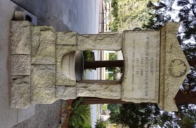
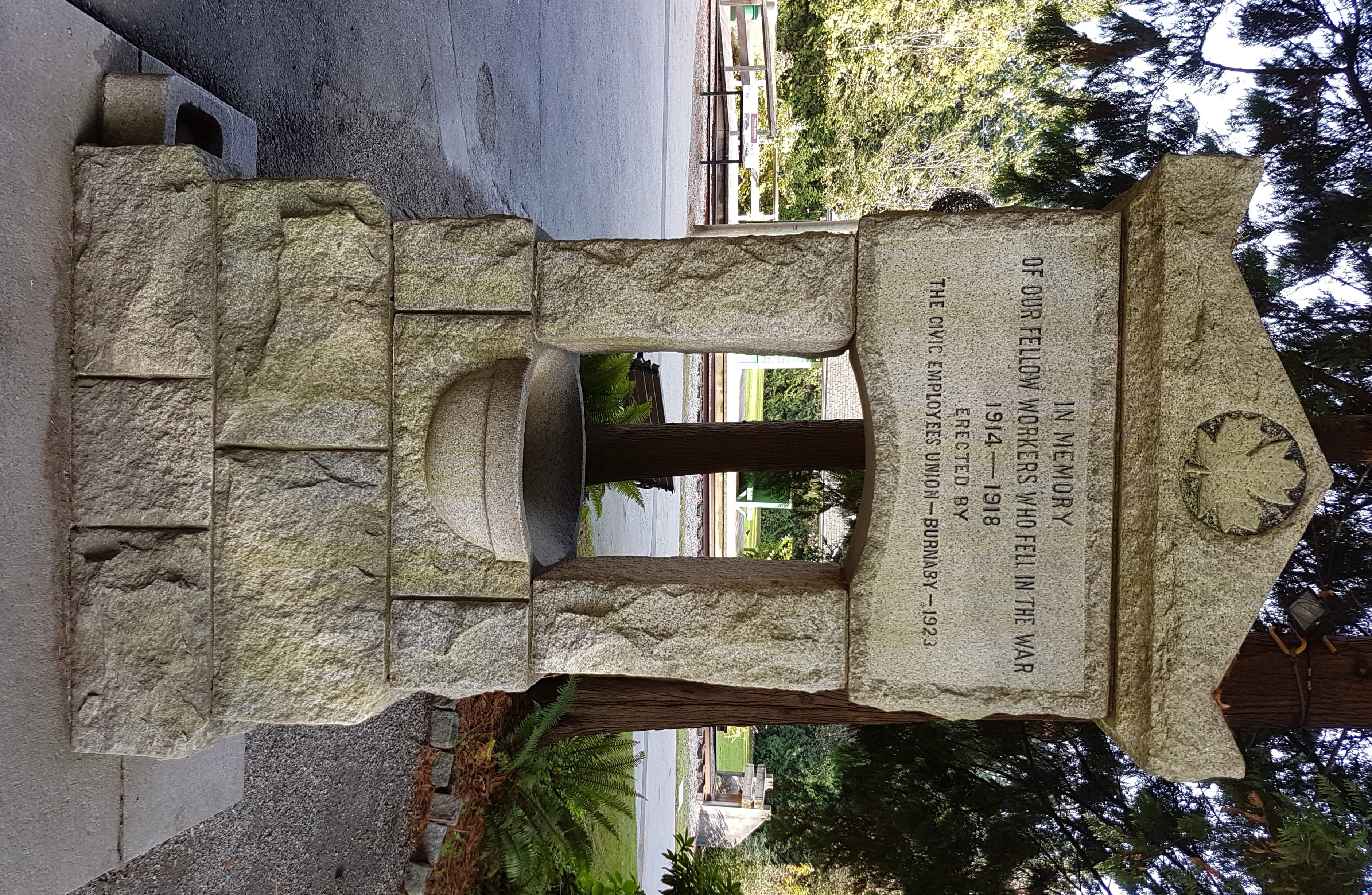
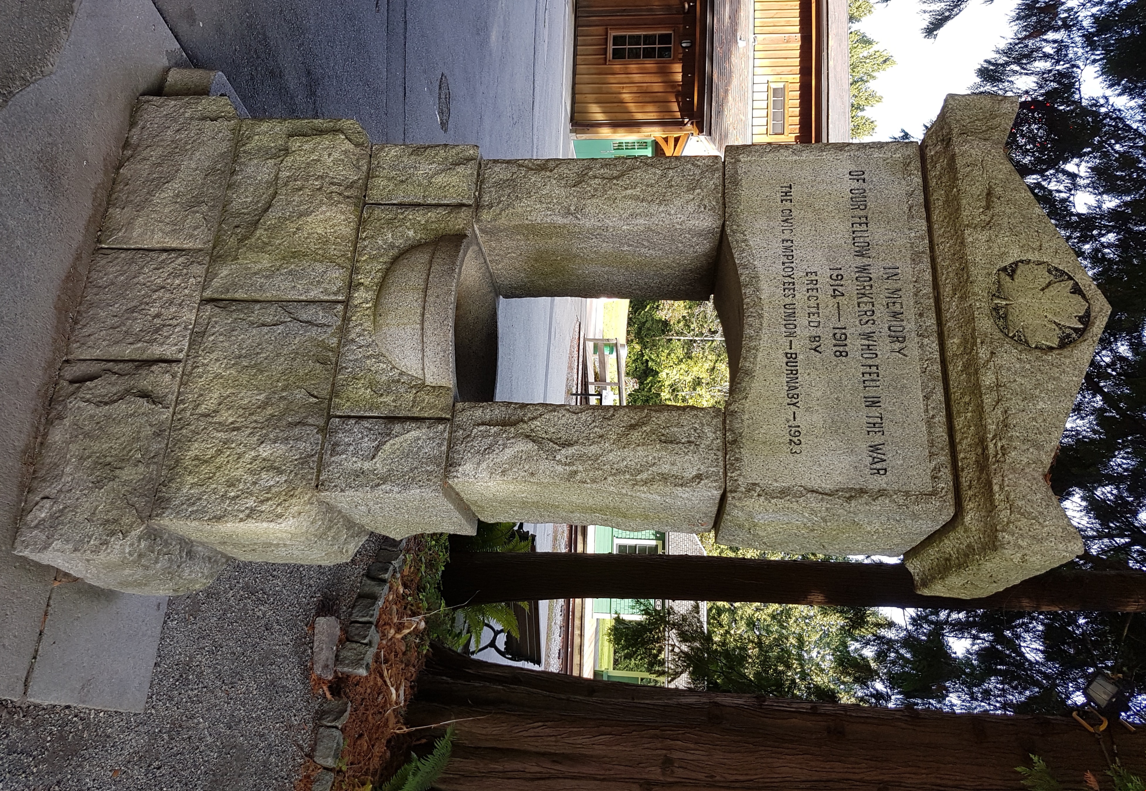
memorial drinking fountain
https://search.heritageburnaby.ca/link/museumartifact8784
- Repository
- Burnaby Village Museum
- Accession Code
- BV985.1242.1
- Description
- The Memorial fountain is made of British Columbia granite. The fountain is currently three courses of rough stone, leading up to the smooth water bowl. Two side pillars carry the memorial stone and the peaked cap stone at the top. The memorial stone's face is smooth, to present the cut text of the memorial. There is a maple leaf cut into the face of the cap stone. The text and the maple leaf are highlighted with black paint. There is a small block at the rear of the fountain to allow children easy access and there is a smooth stone drinking bowl for animals at the proper right of the base of the fountain. The fountain on its original site was four courses high. In its current site the bottom course is set level with the ground. The main bowl is supplied with running water but the animal bowl is dry.
- Object History
- The fountain was erected by the Burnaby Civic Employees Union (now CUPE Local 23) and is dedicated to Union members who died in the Great War. Local stonemason, William Williamson, constructed the fountain in 1923 and it was unveiled on June 17, 1923. In 1977, the fountain was moved and rededicated from the old Burnaby Municipal Hall site to its current site at Burnaby Village Museum. On November 23, 1992, the fountain was given official Heritage Designation by Bylaw # 9807, Municipality of Burnaby
- Marks/Labels
- "IN MEMEORY / OF OUR FELLOW WORKERS WHO FELL IN THE WAR / 1914 - 1918 / ERECTED BY / THE CIVIC EMPLOYEES UNION - BURNABY - 1923", cut into the smoothed face of the memorial stone on the fountain. There is a maple leaf cut into the face of the cap stone on the top of the fountain. The maple leaf motif is also used on veteran grave stones.
- Maker
- William Williamson
- Country Made
- Canada
- Province Made
- British Columbia
- Site/City Made
- Burnaby
- Subjects
- Fountains
- Wars
- Monuments - War Memorials
- Wars - World War, 1914-1918
- Organizations - Unions
- Names
- Williamson, William
Images

Michael Lyshak's casket
https://search.heritageburnaby.ca/link/archivedescription77726
- Repository
- City of Burnaby Archives
- Date
- August 14, 1956
- Collection/Fonds
- Yanko family fonds
- Description Level
- Item
- Physical Description
- 1 photograph : b&w ; 8.5 x 11.5 cm
- Scope and Content
- Photograph of Michael Lyshak's casket in Russian Siberia.
- Repository
- City of Burnaby Archives
- Date
- August 14, 1956
- Collection/Fonds
- Yanko family fonds
- Physical Description
- 1 photograph : b&w ; 8.5 x 11.5 cm
- Material Details
- Secured to album page with photo corners
- Description Level
- Item
- Record No.
- 545-012
- Access Restriction
- In Archives only
- Reproduction Restriction
- No restrictions
- Accession Number
- 2012-09
- Scope and Content
- Photograph of Michael Lyshak's casket in Russian Siberia.
- Subjects
- Monuments - Gravestones
- Media Type
- Photograph
- Notes
- Title based on contents of photograph
- Note in black ink on verso of photograph [not in English]
- Note written on album page reads: "14 August 1956 / Michael Lyshak - Roman Lyshak's father died in Siberia - Russia"
- Note in blue ink on verso of photograph reads: "Roman Lyshak's father died in Russian Siberia / 14 VII 1956"
- Note in pencil ink on verso of photograph reads: "Andrew Natalie grandfather Michael Lyshak"
![Monuments for school sites, [1915] thumbnail](/media/hpo/_Data/_BVM_Cartographic_Material/2003/2003_0083_0010_001.jpg?width=280)
Monuments for school sites
https://search.heritageburnaby.ca/link/museumdescription11915
- Repository
- Burnaby Village Museum
- Date
- [1915]
- Collection/Fonds
- Ronald G. Scobbie collection
- Description Level
- Item
- Physical Description
- 1 architectural drawing : pencil on paper ; 27.5 x 21 cm
- Scope and Content
- Item consists of a drawing titled "Plans of Proposed concrete monuments for corners of / school sites for Burnaby School Board".
- Repository
- Burnaby Village Museum
- Collection/Fonds
- Ronald G. Scobbie collection
- Description Level
- Item
- Physical Description
- 1 architectural drawing : pencil on paper ; 27.5 x 21 cm
- Scope and Content
- Item consists of a drawing titled "Plans of Proposed concrete monuments for corners of / school sites for Burnaby School Board".
- Creator
- McGugan, Donald Johnston
- Subjects
- Buildings - Schools
- Accession Code
- BV003.83.10
- Access Restriction
- No restrictions
- Reproduction Restriction
- No known restrictions
- Date
- [1915]
- Media Type
- Architectural Drawing
- Scan Resolution
- 600
- Scale
- 100
- Notes
- Title based on contents of drawing
- Red crayon marking on plan reads: "001819"
Images
![Monuments for school sites, [1915] thumbnail](/media/hpo/_Data/_BVM_Cartographic_Material/2003/2003_0083_0010_001.jpg)
![Moving into the new McGill Library, [2001] thumbnail](/media/hpo/_Data/_Archives_Images/_Unrestricted/535/535-2509-1.jpg?width=280)
Moving into the new McGill Library
https://search.heritageburnaby.ca/link/archivedescription96954
- Repository
- City of Burnaby Archives
- Date
- [2001]
- Collection/Fonds
- Burnaby NewsLeader photograph collection
- Description Level
- File
- Physical Description
- 2 photographs (tiff) : col.
- Scope and Content
- File contains photographs of the move into the new McGill Library branch. Photographs depict library page Daljit Sidhu shelving books, in silhouette against the Library's windows, and unidentified movers wheeling a cart of library materials into the new building.
- Repository
- City of Burnaby Archives
- Date
- [2001]
- Collection/Fonds
- Burnaby NewsLeader photograph collection
- Physical Description
- 2 photographs (tiff) : col.
- Description Level
- File
- Record No.
- 535-2509
- Access Restriction
- No restrictions
- Reproduction Restriction
- No restrictions
- Accession Number
- 2018-12
- Scope and Content
- File contains photographs of the move into the new McGill Library branch. Photographs depict library page Daljit Sidhu shelving books, in silhouette against the Library's windows, and unidentified movers wheeling a cart of library materials into the new building.
- Subjects
- Buildings - Civic - Libraries
- Names
- Burnaby Public Library
- Media Type
- Photograph
- Photographer
- Bartel, Mario
- Notes
- Title based on caption
- Collected by editorial for use in a June 2001 issue of the Burnaby NewsLeader
- Caption from metadata for 535-2509-1: "Daljit Sidhu, a page at the McGill Library, sorts books onto the shelves in the new library. The McGill branch is closed until September as staff transfer the contents of the old building into the new."
- Caption from metadata for 535-2509-2: "Movers tackle the monumental task of transfering the contents of McGill Library's old building into the new one just behind it. The branch is closed until September for the move, and the demolition of the old branch."
- Geographic Access
- Albert Street
- Street Address
- 4595 Albert Street
- Historic Neighbourhood
- Capitol Hill (Historic Neighbourhood)
- Planning Study Area
- Capitol Hill Area
Images
![Moving into the new McGill Library, [2001] thumbnail](/media/hpo/_Data/_Archives_Images/_Unrestricted/535/535-2509-1.jpg)
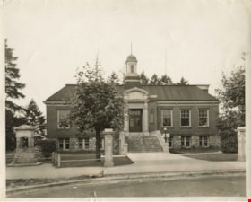
Municipal Hall
https://search.heritageburnaby.ca/link/archivedescription34512
- Repository
- City of Burnaby Archives
- Date
- 1940
- Collection/Fonds
- Burnaby Historical Society fonds
- Description Level
- Item
- Physical Description
- 1 photograph : b&w ; 20.4 x 25.3 cm
- Scope and Content
- Photograph of the exterior of Municipal Hall at Kingsway and Edmonds Street. A sign above the door reads, "Municipal Hall / Burnaby." The First World War memorial fountain, dedicated to Municipal employees who died in the War, can be seen on the left. In 1974, this memorial was relocated from i…
- Repository
- City of Burnaby Archives
- Date
- 1940
- Collection/Fonds
- Burnaby Historical Society fonds
- Subseries
- Photographs subseries
- Physical Description
- 1 photograph : b&w ; 20.4 x 25.3 cm
- Description Level
- Item
- Record No.
- 032-001
- Access Restriction
- No restrictions
- Reproduction Restriction
- No known restrictions
- Accession Number
- BHS2007-04
- Scope and Content
- Photograph of the exterior of Municipal Hall at Kingsway and Edmonds Street. A sign above the door reads, "Municipal Hall / Burnaby." The First World War memorial fountain, dedicated to Municipal employees who died in the War, can be seen on the left. In 1974, this memorial was relocated from its original setting to the site of the Burnaby Village Museum on Deer Lake Avenue.
- Subjects
- Buildings - Civic - City Halls
- Monuments - War Memorials
- Wars - World War, 1914-1918
- Fountains
- Names
- Burnaby City Hall
- Media Type
- Photograph
- Notes
- Title based on contents of photograph
- Geographic Access
- Kingsway
- Street Address
- 7282 Kingsway
- Historic Neighbourhood
- Edmonds (Historic Neighbourhood)
- Planning Study Area
- Stride Avenue Area
Images

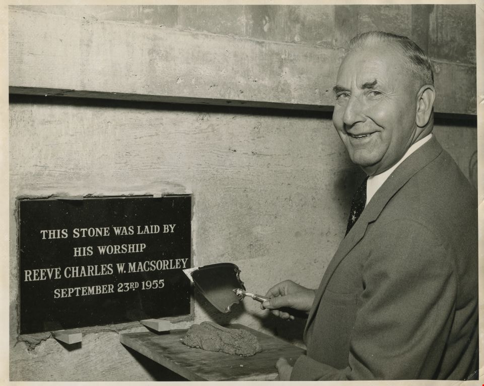
Municipal Hall Cornerstone
https://search.heritageburnaby.ca/link/archivedescription55654
- Repository
- City of Burnaby Archives
- Date
- September 3, 1955
- Collection/Fonds
- Charles MacSorley fonds
- Description Level
- Item
- Physical Description
- 1 photograph : b&w ; 20.5 x 25 cm
- Scope and Content
- Photograph of Burnaby Reeve Charles MacSorley holding a trowel and cement next to the ceremonial plaque for the new municipal hall building. The plaque on the conerstone reads: "This stone was laid by His Worship Reeve Charles W. MacSorley September 23rd 1955."
- Repository
- City of Burnaby Archives
- Date
- September 3, 1955
- Collection/Fonds
- Charles MacSorley fonds
- Physical Description
- 1 photograph : b&w ; 20.5 x 25 cm
- Description Level
- Item
- Record No.
- 486-048
- Access Restriction
- No restrictions
- Reproduction Restriction
- Reproduce for fair dealing purposes only
- Accession Number
- 2005-14
- Scope and Content
- Photograph of Burnaby Reeve Charles MacSorley holding a trowel and cement next to the ceremonial plaque for the new municipal hall building. The plaque on the conerstone reads: "This stone was laid by His Worship Reeve Charles W. MacSorley September 23rd 1955."
- Subjects
- Officials - Mayors and Reeves
- Monuments
- Media Type
- Photograph
- Notes
- Title based on contents of photograph
- Note on verso reads: "1955"
- Geographic Access
- Canada Way
- Street Address
- 4949 Canada Way
- Historic Neighbourhood
- Burnaby Lake (Historic Neighbourhood)
- Planning Study Area
- Douglas-Gilpin Area
Images
Natalia Lyshak's casket
https://search.heritageburnaby.ca/link/archivedescription77737
- Repository
- City of Burnaby Archives
- Date
- March 3, 1958
- Collection/Fonds
- Yanko family fonds
- Description Level
- Item
- Physical Description
- 1 photograph : b&w ; 8 x 13 cm
- Scope and Content
- Photograph of Natalia (Harasimowicz) Lyshak's casket in Brzeg, Poland.
- Repository
- City of Burnaby Archives
- Date
- March 3, 1958
- Collection/Fonds
- Yanko family fonds
- Physical Description
- 1 photograph : b&w ; 8 x 13 cm
- Material Details
- Secured to album page with photo corners
- Description Level
- Item
- Record No.
- 545-014
- Access Restriction
- In Archives only
- Reproduction Restriction
- No restrictions
- Accession Number
- 2012-09
- Scope and Content
- Photograph of Natalia (Harasimowicz) Lyshak's casket in Brzeg, Poland.
- Subjects
- Monuments - Gravestones
- Media Type
- Photograph
- Notes
- Title based on contents of photograph
- Note in blue ink on verso of photograph [not in English]
- Note written on album page reads: "Natalia - Grannie's sister - Roman Lyshak's mother / Brzeg Poland / 24 III '58"
- Note in blue ink on verso of photograph reads: "Roman's mother - Natalia (mum's sister)"
![Nelson's Column in Trafalgar Square, [1880] thumbnail](/media/hpo/_Data/_Archives_Images/_Unrestricted/477/477-760.jpg?width=280)
Nelson's Column in Trafalgar Square
https://search.heritageburnaby.ca/link/archivedescription39441
- Repository
- City of Burnaby Archives
- Date
- [1880]
- Collection/Fonds
- Peers Family and Hill Family fonds
- Description Level
- Item
- Physical Description
- 1 photograph : sepia ; 10.5 x 17.5 cm on page 21.5 x 28 cm (pasted in album)
- Scope and Content
- Photograph of Nelson's Column in Trafalgar Square. This item was in a scrapbook kept by Claude Hill who was originally from England but ultimately settled in the Burnaby Lake area.
- Repository
- City of Burnaby Archives
- Date
- [1880]
- Collection/Fonds
- Peers Family and Hill Family fonds
- Physical Description
- 1 photograph : sepia ; 10.5 x 17.5 cm on page 21.5 x 28 cm (pasted in album)
- Description Level
- Item
- Record No.
- 477-760
- Access Restriction
- No restrictions
- Reproduction Restriction
- No known restrictions
- Accession Number
- 2007-12
- Scope and Content
- Photograph of Nelson's Column in Trafalgar Square. This item was in a scrapbook kept by Claude Hill who was originally from England but ultimately settled in the Burnaby Lake area.
- Subjects
- Monuments
- Media Type
- Photograph
- Notes
- Title based on contents of photograph
Images
![Nelson's Column in Trafalgar Square, [1880] thumbnail](/media/hpo/_Data/_Archives_Images/_Unrestricted/477/477-760.jpg)
![The Phoenix Tower, Chester, [1880] thumbnail](/media/hpo/_Data/_Archives_Images/_Unrestricted/477/477-816.jpg?width=280)
The Phoenix Tower, Chester
https://search.heritageburnaby.ca/link/archivedescription39497
- Repository
- City of Burnaby Archives
- Date
- [1880]
- Collection/Fonds
- Peers Family and Hill Family fonds
- Description Level
- Item
- Physical Description
- 1 photograph : sepia ; 13.2 x 19.5 cm on page 21.5 x 28 cm (pasted in album)
- Scope and Content
- Photograph of the Phoenix Tower in Chester. Inscribed on the plaque on the tower reads the following; "King Charles Stood on this Tower Sept. 24 1645 and Saw His Army Defeated on Rowton Moor." This photograph was in a scrapbook kept by Claude Hill who was originally from England but ultimately sett…
- Repository
- City of Burnaby Archives
- Date
- [1880]
- Collection/Fonds
- Peers Family and Hill Family fonds
- Physical Description
- 1 photograph : sepia ; 13.2 x 19.5 cm on page 21.5 x 28 cm (pasted in album)
- Description Level
- Item
- Record No.
- 477-816
- Access Restriction
- No restrictions
- Reproduction Restriction
- No known restrictions
- Accession Number
- 2007-12
- Scope and Content
- Photograph of the Phoenix Tower in Chester. Inscribed on the plaque on the tower reads the following; "King Charles Stood on this Tower Sept. 24 1645 and Saw His Army Defeated on Rowton Moor." This photograph was in a scrapbook kept by Claude Hill who was originally from England but ultimately settled in the Burnaby Lake area.
- Subjects
- Monuments
- Media Type
- Photograph
- Notes
- Title based on contents of photograph
Images
![The Phoenix Tower, Chester, [1880] thumbnail](/media/hpo/_Data/_Archives_Images/_Unrestricted/477/477-816.jpg)

Pioneer tales of Burnaby
https://search.heritageburnaby.ca/link/museumlibrary5860
- Repository
- Burnaby Village Museum
- Collection
- Digital Reference Collection
- Reference Collection
- Material Type
- Book
- ISBN
- 096928280x
- Call Number
- 971.133 SON COPY 4
- Contributor
- Sone, Michael
- Place of Publication
- Burnaby, B.C.
- Publisher
- Corporation of the District of Burnaby
- Publication Date
- c1987
- Physical Description
- 495 p. : ill. ; 31 cm.
- Inscription
- "TR687 - Bryburgh" / handprinted in pencil on frontend page
- Library Subject (LOC)
- Pioneers--British Columbia--Burnaby
- Frontier and pioneer life
- Biography
- Object History
- Early Burnaby as recalled by the settlers themselves who arrived from every corner of the world between 1888 and 1930, some witnessing incorporation of the district in 1892, all seeking a better life for themselves and especially for their children, all helping transform the wilderness into the modern municipality of today.
- Notes
- "Editor Michael Sone".
- Includes index.
- 4 copies held: copy 4
Images

Digital Books
![Plaque at the Emanuel Parish Church, [1987] thumbnail](/media/Hpo/_Data/_Archives_Images/_Unrestricted/316/353-003.jpg?width=280)
Plaque at the Emanuel Parish Church
https://search.heritageburnaby.ca/link/archivedescription66635
- Repository
- City of Burnaby Archives
- Date
- [1987]
- Collection/Fonds
- Millway family fonds
- Description Level
- Item
- Physical Description
- 1 photograph : col. ; 10 x 15 cm
- Scope and Content
- Photograph of a plaque at Emmanuel Parish Church located on the wall behind the gravestone of the Burnaby family. It reads: "Robert Burnaby / Native of Leicestershire, pioneer and public servant of British Columbia, Canada 1858 to 1874, after whom the District of Burnaby is named, lies buried at …
- Repository
- City of Burnaby Archives
- Date
- [1987]
- Collection/Fonds
- Millway family fonds
- Physical Description
- 1 photograph : col. ; 10 x 15 cm
- Description Level
- Item
- Record No.
- 353-003
- Access Restriction
- No restrictions
- Reproduction Restriction
- Reproduce for fair dealing purposes only
- Accession Number
- 2011-05
- Scope and Content
- Photograph of a plaque at Emmanuel Parish Church located on the wall behind the gravestone of the Burnaby family. It reads: "Robert Burnaby / Native of Leicestershire, pioneer and public servant of British Columbia, Canada 1858 to 1874, after whom the District of Burnaby is named, lies buried at the foot of this wall. / This plaque was unvieled by William Lewarne, Mayor of Burnaby, in July 1987 on a visit to the sister city of Loughborough."
- Subjects
- Monuments
- Names
- Emmanuel Parish Church
- Media Type
- Photograph
- Notes
- Title based on contents of photograph
Images
![Plaque at the Emanuel Parish Church, [1987] thumbnail](/media/Hpo/_Data/_Archives_Images/_Unrestricted/316/353-003.jpg)
![Remembrance Day in Confederation Park, [2000] thumbnail](/media/hpo/_Data/_Archives_Images/_Unrestricted/535/535-1667.jpg?width=280)
Remembrance Day in Confederation Park
https://search.heritageburnaby.ca/link/archivedescription95867
- Repository
- City of Burnaby Archives
- Date
- [2000]
- Collection/Fonds
- Burnaby NewsLeader photograph collection
- Description Level
- Item
- Physical Description
- 1 photograph (tiff) : col.
- Scope and Content
- Photograph of a close-up of the North Burnaby cenotaph in Confederation Park, with two veterans in uniform standing in the background as part of a Remembrance Day ceremony.
- Repository
- City of Burnaby Archives
- Date
- [2000]
- Collection/Fonds
- Burnaby NewsLeader photograph collection
- Physical Description
- 1 photograph (tiff) : col.
- Description Level
- Item
- Record No.
- 535-1667
- Access Restriction
- No restrictions
- Reproduction Restriction
- No restrictions
- Accession Number
- 2018-12
- Scope and Content
- Photograph of a close-up of the North Burnaby cenotaph in Confederation Park, with two veterans in uniform standing in the background as part of a Remembrance Day ceremony.
- Media Type
- Photograph
- Photographer
- Bartel, Mario
- Notes
- Title based on caption
- Collected by editorial for use in a November 2000 issue of the Burnaby NewsLeader
- Caption from metadata: "Brian Simpson, who served in the engine room of the HMCS Sioux during the Korean War, and Reg O'Dell, a driving and drill instructor for the occupation forces in Germany in WWII, pause to reflect on fallen comrades, at the cenotaph in Confederation Park."
- Geographic Access
- Confederation Park
- Willingdon Avenue
- Street Address
- 250 Willingdon Avenue
- Historic Neighbourhood
- Capitol Hill (Historic Neighbourhood)
- Planning Study Area
- Capitol Hill Area
Images
![Remembrance Day in Confederation Park, [2000] thumbnail](/media/hpo/_Data/_Archives_Images/_Unrestricted/535/535-1667.jpg)
Removal of Survey Monuments
https://search.heritageburnaby.ca/link/councilreport44654
- Repository
- City of Burnaby Archives
- Report ID
- 44471
- Meeting Date
- 11-Jul-1955
- Format
- Council - Mayor/Councillor/Staff Report
- Collection/Fonds
- City Council and Office of the City Clerk fonds
- Repository
- City of Burnaby Archives
- Report ID
- 44471
- Meeting Date
- 11-Jul-1955
- Format
- Council - Mayor/Councillor/Staff Report
- Collection/Fonds
- City Council and Office of the City Clerk fonds
Documents
Restoration of the Special Survey Monument Defining the Northeast Corner of DL 135
https://search.heritageburnaby.ca/link/councilreport44371
- Repository
- City of Burnaby Archives
- Report ID
- 44721
- Meeting Date
- 31-Oct-1955
- Format
- Council - Committee Report
- Collection/Fonds
- City Council and Office of the City Clerk fonds
- Repository
- City of Burnaby Archives
- Report ID
- 44721
- Meeting Date
- 31-Oct-1955
- Format
- Council - Committee Report
- Collection/Fonds
- City Council and Office of the City Clerk fonds
Documents
![Robert Burnaby's grave site, [1987] thumbnail](/media/Hpo/_Data/_Archives_Images/_Unrestricted/316/353-002.jpg?width=280)
Robert Burnaby's grave site
https://search.heritageburnaby.ca/link/archivedescription66634
- Repository
- City of Burnaby Archives
- Date
- [1987]
- Collection/Fonds
- Millway family fonds
- Description Level
- Item
- Physical Description
- 1 photograph : col. ; 15 x 10 cm
- Scope and Content
- Photograph of the Burnaby family's joint gravestone for Robert Burnaby (1828-1878), Sarah Burnaby (1822-1873), and Sarah ("widow of Rev. Thomas Burnaby and mother of the above," died 1878 aged 89 years) at the Loughborough Emmanuel Parish Church. Loughborough in Leicestershire, England, has been tw…
- Repository
- City of Burnaby Archives
- Date
- [1987]
- Collection/Fonds
- Millway family fonds
- Physical Description
- 1 photograph : col. ; 15 x 10 cm
- Description Level
- Item
- Record No.
- 353-002
- Access Restriction
- No restrictions
- Reproduction Restriction
- Reproduce for fair dealing purposes only
- Accession Number
- 2011-05
- Scope and Content
- Photograph of the Burnaby family's joint gravestone for Robert Burnaby (1828-1878), Sarah Burnaby (1822-1873), and Sarah ("widow of Rev. Thomas Burnaby and mother of the above," died 1878 aged 89 years) at the Loughborough Emmanuel Parish Church. Loughborough in Leicestershire, England, has been twinned with Burnaby, British Columbia.
- Subjects
- Monuments - Gravestones
- Names
- Emmanuel Parish Church
- Media Type
- Photograph
- Notes
- Title based on contents of photograph
Images
![Robert Burnaby's grave site, [1987] thumbnail](/media/Hpo/_Data/_Archives_Images/_Unrestricted/316/353-002.jpg)