Narrow Results By
Subject
- Advertising Medium 8
- Advertising Medium - Flyer 7
- Advertising Medium - Signs and Signboards 10
- Aerial Photographs 1
- Agricultural Tools and Equipment 4
- Agricultural Tools and Equipment - Cultivators 1
- Agricultural Tools and Equipment - Gardening Equipment 2
- Agriculture 5
- Agriculture - Crops 4
- Agriculture - Farms 10
- Agriculture - Fruit and Berries 1
- Animals - Dogs 1
Person / Organization
- Alderson, Steve 2
- Allen, James Charles 1
- A. MacKenzie and Company Jubilee Store 7
- Arlington's Market 1
- Babey, Beverley 2
- Bateman Family 1
- Baxter's Market 1
- Bonsor Recreation Complex 1
- Brentwood Shopping Centre 1
- British Columbia Electric Railway Company 3
- British Columbia Institute of Technology 1
- Burke, Kevin 1
![Burnaby Bulldogs marketing, [2001] thumbnail](/media/hpo/_Data/_Archives_Images/_Unrestricted/535/535-2586-1.jpg?width=280)
Burnaby Bulldogs marketing
https://search.heritageburnaby.ca/link/archivedescription97058
- Repository
- City of Burnaby Archives
- Date
- [2001]
- Collection/Fonds
- Burnaby NewsLeader photograph collection
- Description Level
- File
- Physical Description
- 2 photographs (tiff) : col.
- Scope and Content
- File contains photographs of players from the Burnaby Bulldogs undertaking efforts to boot season ticket sales. Photographs depict players Adam Taylor, Mike Distefano, and Mike Bickley stuffing promotional envelopes and Distefano and Bickley reviewing a map for their canvassing route with marketing…
- Repository
- City of Burnaby Archives
- Date
- [2001]
- Collection/Fonds
- Burnaby NewsLeader photograph collection
- Physical Description
- 2 photographs (tiff) : col.
- Description Level
- File
- Record No.
- 535-2586
- Access Restriction
- No restrictions
- Reproduction Restriction
- No restrictions
- Accession Number
- 2018-12
- Scope and Content
- File contains photographs of players from the Burnaby Bulldogs undertaking efforts to boot season ticket sales. Photographs depict players Adam Taylor, Mike Distefano, and Mike Bickley stuffing promotional envelopes and Distefano and Bickley reviewing a map for their canvassing route with marketing manager Sharon Goldstein.
- Names
- Burnaby Bulldogs
- Media Type
- Photograph
- Photographer
- Bartel, Mario
- Notes
- Title based on caption
- Collected by editorial for use in a July 2001 issue of the Burnaby NewsLeader
- Caption from metadata for 535-2586-1: "Adam Taylor, Mike Distefano and Mike Bickley, of the Burnaby Bulldogs, spend an afternoon stuffing envelopes as the team tries to boost its flagging season ticket sales."
- Caption from metadata for 535-2586-2: "Sharon Goldstein, marketing manager of the Burnaby Bulldogs, plots the day's canvassing route with players Mike Distefano and Mike Bickley, as the team goes door-to-door in an effort to boost season ticket sales."
Images
![Burnaby Bulldogs marketing, [2001] thumbnail](/media/hpo/_Data/_Archives_Images/_Unrestricted/535/535-2586-1.jpg)

Envelope - Paneloc marketing limited
https://search.heritageburnaby.ca/link/museumdescription15064
- Repository
- Burnaby Village Museum
- Date
- 15 Nov. 1962
- Collection/Fonds
- Elmer Wilson Martin fonds
- Description Level
- Item
- Physical Description
- 1 envelope
- Scope and Content
- Item consists of an envelope with the return address and logo of Paneloc Marketing Ltd., 4217 East Hasting Street Burnaby B.C.
- Repository
- Burnaby Village Museum
- Collection/Fonds
- Elmer Wilson Martin fonds
- Description Level
- Item
- Physical Description
- 1 envelope
- Material Details
- green coloured stationery envelope
- Scope and Content
- Item consists of an envelope with the return address and logo of Paneloc Marketing Ltd., 4217 East Hasting Street Burnaby B.C.
- Accession Code
- BV019.37.15
- Access Restriction
- No restrictions
- Reproduction Restriction
- No known restrictions
- Date
- 15 Nov. 1962
- Media Type
- Textual Record
- Scan Resolution
- 600
- Scan Date
- February 4, 2021
- Scale
- 100
- Notes
- Title based on contents of item
Images

![Paneloc marketing report, [between 1957 and 1960] thumbnail](/media/hpo/_Data/_BVM_Images/2019/2019_0040_0003_001.jpg?width=280)
Paneloc marketing report
https://search.heritageburnaby.ca/link/museumdescription15067
- Repository
- Burnaby Village Museum
- Date
- [between 1957 and 1960]
- Collection/Fonds
- Elmer Wilson Martin fonds
- Description Level
- Item
- Physical Description
- 1 report : 5 photographs + 6 architectural drawings : blueline prints ; 55 x 85 cm + 1 architectural drawing : blueline print ; 46 x 55 cm
- Scope and Content
- Item consists of a report created by Paneloc Marketing Ltd. 4217 Hastings Street Burnaby B.C. Architectural drawings within the report are drawn by Jack Pearl and designed by Elmer W. Martin, P. Engineer. Architectural drawings included in the report are titled; Paneloc Homes - All Models (2 drawin…
- Repository
- Burnaby Village Museum
- Collection/Fonds
- Elmer Wilson Martin fonds
- Description Level
- Item
- Physical Description
- 1 report : 5 photographs + 6 architectural drawings : blueline prints ; 55 x 85 cm + 1 architectural drawing : blueline print ; 46 x 55 cm
- Material Details
- Scales differ between 1"=60" and 3/4"=1'-0"
- Scope and Content
- Item consists of a report created by Paneloc Marketing Ltd. 4217 Hastings Street Burnaby B.C. Architectural drawings within the report are drawn by Jack Pearl and designed by Elmer W. Martin, P. Engineer. Architectural drawings included in the report are titled; Paneloc Homes - All Models (2 drawings); Paneloc Homes - Model 6 - 28 Panel (3 drawings) ; Paneloc Homes - Model 6-24 Panel (1 drawing) ; Paneloc Homes - Model 4 -20 Panel (1 drawing). The report includes five photographs of paneloc homes including two of completed homes and three of a paneloc building in various stages of assembly.
- Responsibility
- Panel Marketing Limited
- Accession Code
- BV019.40.3
- Access Restriction
- No restrictions
- Reproduction Restriction
- May be restricted by third party rights
- Date
- [between 1957 and 1960]
- Media Type
- Photograph
- Architectural Drawing
- Scan Resolution
- 600
- Scan Date
- February 5, 2021
- Scale
- 100
- Notes
- Title based on contents of report
- Architectural drawings were unfolded and removed from duotang binding
- According to an advertisement dated June 14, 1957 for Paneloc Manufacturing in the Vancouver Province newspaper, a paneloc display model was available for viewing at 6635 East Hastings Street in Burnaby. Some of the photographs within this report may have been at this location.
- Architectural drawings have reproduction and access restrictions. Contact Burnaby Village Museum to view.
Images
![Paneloc marketing report, [between 1957 and 1960] thumbnail](/media/hpo/_Data/_BVM_Images/2019/2019_0040_0003_001.jpg)


Paper heart by Sophie Armstrong
https://search.heritageburnaby.ca/link/museumdescription14749
- Repository
- Burnaby Village Museum
- Date
- March 2020
- Collection/Fonds
- Burnaby Village Museum COVID-19 collection
- Description Level
- Item
- Physical Description
- 1 drawing : wax crayon on pink construction paper ; 20 x 23.5 cm
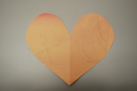
- Scope and Content
- Item consists of a heart that has been cut out of pink coloured construction paper. One side of the heart has contains a child's drawing with markings in purple crayon while the other side is blank. The side with the markings is faded from exposure due to sunlight after being hung in a window.
- Repository
- Burnaby Village Museum
- Collection/Fonds
- Burnaby Village Museum COVID-19 collection
- Description Level
- Item
- Physical Description
- 1 drawing : wax crayon on pink construction paper ; 20 x 23.5 cm
- Scope and Content
- Item consists of a heart that has been cut out of pink coloured construction paper. One side of the heart has contains a child's drawing with markings in purple crayon while the other side is blank. The side with the markings is faded from exposure due to sunlight after being hung in a window.
- History
- This was a heart the Armstrong family made in the last week of March when things were starting to get very scary and they wanted to share their message of love and support to the world. The heart was decorated on one side by Sophie (age 1), Kimberly's youngest daughter (of two). The heart remained on the window until mid July 2020.
- Creator
- Armstrong, Sophie
- Subjects
- Arts - Drawings
- Crafts
- Pandemics - COVID-19
- Responsibility
- Paneloc Marketing Limited
- Accession Code
- BV020.24.1
- Access Restriction
- No restrictions
- Reproduction Restriction
- No known restrictions
- Date
- March 2020
- Media Type
- Graphic Material
- Notes
- Title based on contents of item
Images


Elmer and men on roof of paneloc house
https://search.heritageburnaby.ca/link/museumdescription15089
- Repository
- Burnaby Village Museum
- Date
- May 1967
- Collection/Fonds
- Elmer Wilson Martin fonds
- Description Level
- Item
- Physical Description
- 1 photograph : b&w ; 9 x 12.5 cm
- Scope and Content
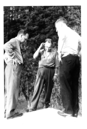
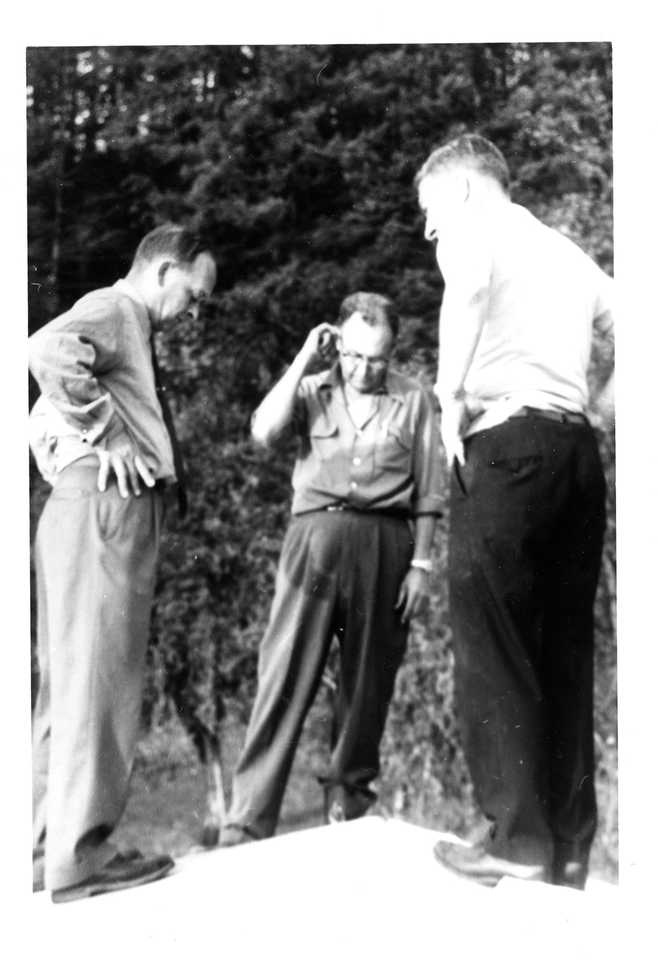
- Photograph of Elmer Wilson Martin with two unidentified men standing on the roof of a paneloc house. Elmer Wilson is standing on the left.
- Repository
- Burnaby Village Museum
- Collection/Fonds
- Elmer Wilson Martin fonds
- Description Level
- Item
- Physical Description
- 1 photograph : b&w ; 9 x 12.5 cm
- Scope and Content
- Photograph of Elmer Wilson Martin with two unidentified men standing on the roof of a paneloc house. Elmer Wilson is standing on the left.
- Geographic Access
- Hastings Street
- Street Address
- 6635 Hastings Street
- Accession Code
- BV019.40.29
- Access Restriction
- No restrictions
- Reproduction Restriction
- May be restricted by third party rights
- Date
- May 1967
- Media Type
- Photograph
- Scan Resolution
- 600
- Scan Date
- February 8, 2021
- Scale
- 100
- Photographer
- Supové, Larry
- Notes
- Title based on contents of photograph
- Stamp on verso of photograph reads: "SHOT BY / Larry Supové"
- According to an advertisement dated June 14, 1957 for Paneloc Manufacturing in the Vancouver Province newspaper, a paneloc display model was available for viewing at 6635 East Hastings Street in Burnaby. The model in this photograph may be at this location.
Images
Elmer and Reta Martin in front of paneloc house
https://search.heritageburnaby.ca/link/museumdescription15088
- Repository
- Burnaby Village Museum
- Date
- May 1967
- Collection/Fonds
- Elmer Wilson Martin fonds
- Description Level
- Item
- Physical Description
- 1 photograph : b&w ; 9 x 12.5 cm
- Scope and Content
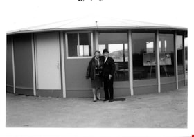
- Photograph of Elmer Wilson Martin with his wife Renatta "Reta" Boyd Martin. The couple are standing in front of a paneloc house.
- Repository
- Burnaby Village Museum
- Collection/Fonds
- Elmer Wilson Martin fonds
- Description Level
- Item
- Physical Description
- 1 photograph : b&w ; 9 x 12.5 cm
- Scope and Content
- Photograph of Elmer Wilson Martin with his wife Renatta "Reta" Boyd Martin. The couple are standing in front of a paneloc house.
- Geographic Access
- Hastings Street
- Street Address
- 6635 Hastings Street
- Accession Code
- BV019.40.28
- Access Restriction
- No restrictions
- Reproduction Restriction
- May be restricted by third party rights
- Date
- May 1967
- Media Type
- Photograph
- Scan Resolution
- 600
- Scan Date
- February 8, 2021
- Scale
- 100
- Notes
- Title based on contents of photograph
- Stamp on verso of photograph reads: "F 791"
- According to an advertisement dated June 14, 1957 for Paneloc Manufacturing in the Vancouver Province newspaper, a paneloc display model was available for viewing at 6635 East Hastings Street in Burnaby. The model in this photograph may be at this location.
Images

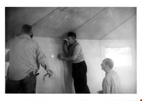
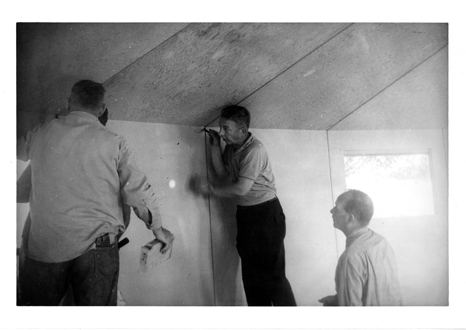
Men inside paneloc building
https://search.heritageburnaby.ca/link/museumdescription15090
- Repository
- Burnaby Village Museum
- Date
- May 1967
- Collection/Fonds
- Elmer Wilson Martin fonds
- Description Level
- Item
- Physical Description
- 1 photograph : b&w ; 9 x 12.5 cm
- Scope and Content
- Photograph of four men standing inside of a paneloc building. Elmer Wilson Martin is identified standing on the far right. One of the men is standing on a riser and another is holding a level. The men appear to be inspecting the seams between the paneloc panels.
- Repository
- Burnaby Village Museum
- Collection/Fonds
- Elmer Wilson Martin fonds
- Description Level
- Item
- Physical Description
- 1 photograph : b&w ; 9 x 12.5 cm
- Scope and Content
- Photograph of four men standing inside of a paneloc building. Elmer Wilson Martin is identified standing on the far right. One of the men is standing on a riser and another is holding a level. The men appear to be inspecting the seams between the paneloc panels.
- Geographic Access
- Hastings Street
- Street Address
- 6635 Hastings Street
- Accession Code
- BV019.40.30
- Access Restriction
- No restrictions
- Reproduction Restriction
- May be restricted by third party rights
- Date
- May 1967
- Media Type
- Photograph
- Scan Resolution
- 600
- Scan Date
- February 8, 2021
- Scale
- 100
- Photographer
- Supové, Larry
- Notes
- Title based on contents of photograph
- Stamp on verso of photograph reads: "SHOT BY / Larry Supové"
- According to an advertisement dated June 14, 1957 for Paneloc Manufacturing in the Vancouver Province newspaper, a paneloc display model was available for viewing at 6635 East Hastings Street in Burnaby. The model in this photograph may be at this location.
Images
![Men with paneloc segments, [197-] thumbnail](/media/hpo/_Data/_BVM_Images/2019/2019_0040_0022_001.jpg?width=280)
Men with paneloc segments
https://search.heritageburnaby.ca/link/museumdescription15087
- Repository
- Burnaby Village Museum
- Date
- [197-]
- Collection/Fonds
- Elmer Wilson Martin fonds
- Description Level
- Item
- Physical Description
- 1 photograph : b&w ; 9 x 12.5 cm
- Scope and Content
- Photograph of a group of men standing on boards layed out on the ground near a stack of paneloc pieces. Elmer Martin is identified standing in front of a tractor second from right. A tractor, a pile of brush and an old automobile are visible in the background. Two of the men are dressed in painters…
- Repository
- Burnaby Village Museum
- Collection/Fonds
- Elmer Wilson Martin fonds
- Description Level
- Item
- Physical Description
- 1 photograph : b&w ; 9 x 12.5 cm
- Scope and Content
- Photograph of a group of men standing on boards layed out on the ground near a stack of paneloc pieces. Elmer Martin is identified standing in front of a tractor second from right. A tractor, a pile of brush and an old automobile are visible in the background. Two of the men are dressed in painters coveralls.
- Accession Code
- BV019.40.22
- Access Restriction
- No restrictions
- Reproduction Restriction
- May be restricted by third party rights
- Date
- [197-]
- Media Type
- Photograph
- Scan Resolution
- 600
- Scan Date
- February 8, 2021
- Scale
- 100
- Notes
- Title based on contents of photograph
Images
![Men with paneloc segments, [197-] thumbnail](/media/hpo/_Data/_BVM_Images/2019/2019_0040_0022_001.jpg)
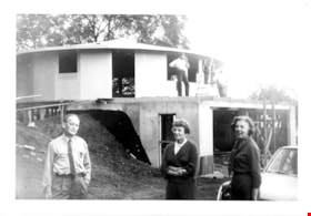
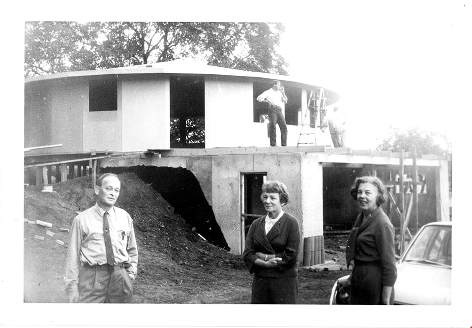
Paneloc building under construction
https://search.heritageburnaby.ca/link/museumdescription15091
- Repository
- Burnaby Village Museum
- Date
- May 1967
- Collection/Fonds
- Elmer Wilson Martin fonds
- Description Level
- Item
- Physical Description
- 1 photograph : b&w ; 9 x 12.5 cm
- Scope and Content
- Photograph of Elmer Wilson Martin (far left), Reta Martin and an unidentified woman standing on a construction site whereby a paneloc building is being built. The partially finished paneloc building is behind them. Three unidentified men are visible standing on the roof of the garage situated under…
- Repository
- Burnaby Village Museum
- Collection/Fonds
- Elmer Wilson Martin fonds
- Description Level
- Item
- Physical Description
- 1 photograph : b&w ; 9 x 12.5 cm
- Scope and Content
- Photograph of Elmer Wilson Martin (far left), Reta Martin and an unidentified woman standing on a construction site whereby a paneloc building is being built. The partially finished paneloc building is behind them. Three unidentified men are visible standing on the roof of the garage situated under the paneloc building.
- Geographic Access
- Hastings Street
- Street Address
- 6635 Hastings Street
- Accession Code
- BV019.40.31
- Access Restriction
- No restrictions
- Reproduction Restriction
- May be restricted by third party rights
- Date
- May 1967
- Media Type
- Photograph
- Scan Resolution
- 600
- Scan Date
- February 8, 2021
- Scale
- 100
- Photographer
- Supové, Larry
- Notes
- Title based on contents of photograph
- Stamp on verso of photograph reads: "SHOT BY / Larry Supové"
- According to an advertisement dated June 14, 1957 for Paneloc Manufacturing in the Vancouver Province newspaper, a paneloc display model was available for viewing at 6635 East Hastings Street in Burnaby. The model in this photograph may be at this location.
Images

Chinese Market Gardens
https://search.heritageburnaby.ca/link/landmark772
- Repository
- Burnaby Heritage Planning
- Repository
- Burnaby Heritage Planning
- Geographic Access
- Marine Way
- Heritage Value
- The importance of the Chinese-Canadian market gardens in the Big Bend area of Burnaby was described in 1912 by The British Columbian as such: "The Chinese farmers have been for years developing and reaping the benefits of the rich soil. By draining the land with a series of ditches, the [growers] have reduced what was once little better than a cranberry marsh into a richly productive farming area which is one of the most valuable assets to...Burnaby." Many Chinese-Canadian families who had for years leased their farms began to purchase land in the 1950s and cultivated small parcels of up to 10 acres for growing assorted Canadian and Chinese vegetables for sale - either wholesale or in the market's roadside stands on Marine Drive, frequented by many loyal Burnaby customers.
- Historic Neighbourhood
- Fraser Arm (Historic Neighbourhood)
- Planning Study Area
- Big Bend Area
Images


Joseph & Jane Wintemute House
https://search.heritageburnaby.ca/link/landmark523
- Repository
- Burnaby Heritage Planning
- Description
- The Wintemute House is a large two-storey wood-frame Victorian era country farm house with Victorian Italianate detailing. Designed in a symmetrical Foursquare form, it features a low-pitched hipped roof with deep eaves. Later additions to the rear of the house, and the extensive wraparound veranda…
- Associated Dates
- 1891
- Formal Recognition
- Heritage Designation, Community Heritage Register
- Other Names
- Burnett House
- Street View URL
- Google Maps Street View
- Repository
- Burnaby Heritage Planning
- Other Names
- Burnett House
- Geographic Access
- Berkley Street
- Associated Dates
- 1891
- Formal Recognition
- Heritage Designation, Community Heritage Register
- Enactment Type
- Bylaw No. 6889
- Enactment Date
- 07/03/1977
- Description
- The Wintemute House is a large two-storey wood-frame Victorian era country farm house with Victorian Italianate detailing. Designed in a symmetrical Foursquare form, it features a low-pitched hipped roof with deep eaves. Later additions to the rear of the house, and the extensive wraparound verandah and porte-cochere, were Edwardian era additions. It is located on its original site, in the modern subdivision of Buckingham Heights in southeast Burnaby. The Burnett House is one of the oldest surviving houses in Burnaby.
- Heritage Value
- Built circa 1891, the Joseph and Jane Wintemute House is valued as a representation of the early history of Burnaby and its agricultural origins. Built prior to the civic incorporation of Burnaby in 1892, the house was situated to face Douglas Road (now Canada Way), one of the first roads built to connect the rural farmlands of Burnaby to New Westminster. The original large property has been extensively subdivided and the house is now isolated in a modern subdivision. Designated in 1977, the Wintemute House is also significant as Burnaby's first protected municipal heritage site. The house is valued for its association with Joseph S. Wintemute (1832-1911) and Jane Wintemute (1832-1910), who came to British Columbia from Port Stanley, Ontario in 1865, traveling via the Isthmus of Panama. Joseph Wintemute, a skilled carpenter and contractor by trade, operated the Wintemute Furniture Factory in New Westminster, the first furniture plant established on the mainland of British Columbia. In 1891, he acquired this property, where he set up a cord wood sawmill to supply his factory. Wintemute was likely responsible for the design and construction of this commodious structure, as it was built in an Eastern Canadian style he would have been familiar with. After the lands were cleared of timber, the Wintemutes developed the property into a typical small-scale 'market garden,’ involved in the production of vegetables and fruits, such as strawberries, for sale at the New Westminster City Market. The Wintemute House is additionally significant for its association with the speculative land boom that occurred prior to the First World War, and ongoing suburban subdivision. Charles Gordon, a real estate agent, acquired the Wintemute farm and subdivided the acreage, which he marketed through the People’s Trust Company as 'Montrelynview' and offered this house as a draw prize to lot purchasers. With the collapse of the land boom, the house remained in Gordon’s possession until 1929 when it was purchased by his brother-in-law, Geoffrey Burnett, a local surveyor responsible for many of the original land surveys of Burnaby. David Burnett, Geoffrey's son, requested designation of the house when the family decided to subdivide the remaining 1.4 hectares of property in 1977. Furthermore, the Wintemute House is valued as an excellent example of a Victorian era country farm house, based loosely on the traditional farmhouses seen commonly in nineteenth century Ontario. Designed in a vernacular version of the Victorian Italianate style, the house displays restrained detailing, including several original multi-paned windows notable for their vertical proportions. The house retains many original exterior features, and the original interior layout, although modernized during the Edwardian era, is substantially intact, including finely crafted maple and cedar interior millwork that was produced by the Wintemute Furniture Factory. From 1904 to 1910, Charles Gordon, the second owner, made a number of alterations to the house including the addition of the wrap-around verandah, a porte-cochere and a 7.6 metre by 9 metre billiard room in the Arts and Crafts style, beamed and panelled in Douglas Fir. These later additions and alterations have value in demonstrating the evolution of the house and property and changing tastes at the turn of the nineteenth century.
- Defining Elements
- Key elements that define the heritage character of the Wintemute House include its: - picturesque original setting with views to the North Shore - residential form, scale and massing as expressed by its symmetrical cubic form and two-storey height, with later additions to the rear - Victorian Italianate architectural features such as the vertically-proportioned original windows with vestigial window hoods, low-pitched hipped roof and Classical Revival details such as the corner boards articulated as pilasters - hipped roof with deep boxed eaves - horizontal lapped narrow wooden siding - second storey balcony over front entry - wide wraparound columned verandah with porte-cochere, with square trimmed columns - irregular fenestration: original Victorian era double-hung 6-over-6 wood-sash windows with vertical proportions and segmental arched tops; Edwardian era double-hung 1-over-1 wooden-sash windows; and Edwardian era wooden-sash casement window assemblies with leaded transoms - central front entry with sidelights and transom - multi-paned French doors opening out to verandah - interior features such as its 3.7 metre ceiling height on the main and second floors; the coal grate fireplace with elaborate woodwork and glazed tile surround in the front parlour; five other fireplaces throughout the house; maple and cedar interior millwork; and the Douglas Fir panelled and beamed billiard room with hidden doors, seven-panelled doors, original light fixtures and mouldings - internal red brick chimneys with corbelled caps
- Historic Neighbourhood
- Burnaby Lake (Historic Neighbourhood)
- Planning Study Area
- Morley-Buckingham Area
- Function
- Primary Historic--Single Dwelling
- Primary Current--Single Dwelling
- Community
- Burnaby
- Cadastral Identifier
- 003-297-152
- Boundaries
- The Wintemute House is comprised of a single residential lot located at 7640 Berkley Street, Burnaby.
- Area
- 1566.73
- Contributing Resource
- Building
- Ownership
- Private
- Names
- Wintemute, Joseph
- Street Address
- 7640 Berkley Street
- Street View URL
- Google Maps Street View
Images


Fraser Arm Neighbourhood
https://search.heritageburnaby.ca/link/landmark708
- Repository
- Burnaby Heritage Planning
- Associated Dates
- 1925-1954
- Heritage Value
- By the late 1920s, the Fraser Arm Neighbourhood in Burnaby was developing into an industrial and manufacturing district. In 1931, the Canadian National Railway built a bridge over the Fraser River from Burnaby to Lulu Island and advertised that over 30 industries were currently operating along the North Fraser. Along with industries, this district remained an important agricultural area for the Lower Mainland. Chinese market gardens continued to develop and thrive and in 1926, the Vancouver Sun estimated that that Chinese farms in the Lower Fraser Valley then supplied 90 per cent of all green vegetables consumed in the Vancouver market area.
- Historic Neighbourhood
- Fraser Arm (Historic Neighbourhood)
- Planning Study Area
- Big Bend Area
Images


H.T. Ceperley Estate 'Fairacres' Root House
https://search.heritageburnaby.ca/link/landmark527
- Repository
- Burnaby Heritage Planning
- Description
- The ‘Fairacres’ Root House is a long, low one-storey masonry building, measuring 4.6 metres by 9.1 metres, with massively buttressed concrete walls and foundations. Built into sloping ground adjacent to the location of the former greenhouses, the surviving orchard and the kitchen entrance of the ma…
- Associated Dates
- 1908
- Formal Recognition
- Heritage Designation, Community Heritage Register
- Repository
- Burnaby Heritage Planning
- Geographic Access
- Deer Lake Avenue
- Associated Dates
- 1908
- Formal Recognition
- Heritage Designation, Community Heritage Register
- Enactment Type
- Bylaw No. 9807
- Enactment Date
- 23/11/1992
- Description
- The ‘Fairacres’ Root House is a long, low one-storey masonry building, measuring 4.6 metres by 9.1 metres, with massively buttressed concrete walls and foundations. Built into sloping ground adjacent to the location of the former greenhouses, the surviving orchard and the kitchen entrance of the main house, 'Fairacres,' this functional structure was used as a frost-free store for fruit and vegetables for the family's use.
- Heritage Value
- The outbuildings at 'Fairacres' are a rare surviving architecturally-designed ensemble of agricultural structures that exist in complementary harmony with the main estate house. Architect Robert Mackay Fripp (1858-1917), an outspoken advocate of Arts and Crafts design, was retained by the Ceperleys to design several original outbuildings on their estate. The Root House is important as a rare surviving, and exceptionally large, example of this building type in the Vancouver region. Unusual in the fact that an architect designed a building of such modest aspirations, it is also remarkable in its method of construction. The use of concrete as a structural material is one of the earliest in the region and extraordinary for its use on such a modest vernacular outbuilding; root cellars were typically built of loose stone. Built in 1908, the Root House was significantly altered in the 1960s and restored to its original design in 2000. The building is significant as an indicator of the market gardening activity in the area around Deer Lake and of the country-house self-sufficiency practiced by the Ceperley family. The Root House illustrates the cultural, aesthetic, and lifestyle values of the Ceperleys in constructing such a large building for storing their own produce.
- Defining Elements
- The outbuildings at 'Fairacres' are a rare surviving architecturally-designed ensemble of agricultural structures that exist in complementary harmony with the main estate house. Architect Robert Mackay Fripp (1858-1917), an outspoken advocate of Arts and Crafts design, was retained by the Ceperleys to design several original outbuildings on their estate. The Root House is important as a rare surviving, and exceptionally large, example of this building type in the Vancouver region. Unusual in the fact that an architect designed a building of such modest aspirations, it is also remarkable in its method of construction. The use of concrete as a structural material is one of the earliest in the region and extraordinary for its use on such a modest vernacular outbuilding; root cellars were typically built of loose stone. Built in 1908, the Root House was significantly altered in the 1960s and restored to its original design in 2000. The building is significant as an indicator of the market gardening activity in the area around Deer Lake and of the country-house self-sufficiency practiced by the Ceperley family. The Root House illustrates the cultural, aesthetic, and lifestyle values of the Ceperleys in constructing such a large building for storing their own produce.
- Locality
- Deer Lake Park
- Historic Neighbourhood
- Burnaby Lake (Historic Neighbourhood)
- Planning Study Area
- Douglas-Gilpin Area
- Architect
- Robert Mackay Fripp
- Function
- Primary Historic--Outbuilding
- Secondary Historic--Food Storage
- Community
- Burnaby
- Cadastral Identifier
- P.I.D. No. 004-493-311 Legal Description: Block 3 Except: Part subdivided by Plan 26865, District Lot 79, Group 1, New Westminster District, Plan 536
- Boundaries
- ‘Fairacres’ is comprised of a single municipally-owned property located at 6344 Deer Lake Avenue, Burnaby.
- Area
- 17,065.00
- Contributing Resource
- Building
- Landscape Feature
- Ownership
- Public (local)
- Other Collection
- Burnaby Historical Society, Community Archives: Ceperley Photograph Album
- Documentation
- Heritage Site Files: PC77000 20. City of Burnaby Planning and Building Department, 4949 Canada Way, Burnaby, B.C., V5G 1M2
- Street Address
- 6344 Deer Lake Avenue
Images


W.J. Walker House
https://search.heritageburnaby.ca/link/landmark548
- Repository
- Burnaby Heritage Planning
- Description
- The W.J. Walker House is a rustic cottage at the eastern end of Deer Lake and is now located within Deer Lake Park. It is a one-and-a-half-storey wood-frame shingle-clad vernacular structure.
- Associated Dates
- 1907
- Formal Recognition
- Heritage Designation, Community Heritage Register
- Other Names
- William & Olive Walker Residence
- Street View URL
- Google Maps Street View
- Repository
- Burnaby Heritage Planning
- Other Names
- William & Olive Walker Residence
- Geographic Access
- Sperling Avenue
- Associated Dates
- 1907
- Formal Recognition
- Heritage Designation, Community Heritage Register
- Enactment Type
- Bylaw No. 11593
- Enactment Date
- 15/09/2003
- Description
- The W.J. Walker House is a rustic cottage at the eastern end of Deer Lake and is now located within Deer Lake Park. It is a one-and-a-half-storey wood-frame shingle-clad vernacular structure.
- Heritage Value
- The W.J. Walker House is important as it references the economic activities in the Deer Lake area prior to the development of grand mansions in Deer Lake Park. It is typical of the cottages built by workers in the market gardening and lumber-milling industries that operated around the lake primarily from 1904-1925. This is the only cottage on the shores of Deer Lake remaining from the era when these industries were the focus of the area's development. The house demonstrates the aesthetic values of Olive Walker and her husband William J. Walker, a ‘rancher’ (market gardener, poultry farmer) who built the house as a retirement home, in the quality of its construction and interior finishing. The Craftsman styling of the house was a popular design vocabulary of the time and reflected the modern taste and values of the owner. The construction of the house also illustrates the use of locally milled lumber. The extant cold safe at the side of house is indicative of food storage methods in the early twentieth century and provides insight to the everyday domestic lives of people at this time.
- Defining Elements
- Key elements that define the heritage character of the W.J. Walker House include its: - location close to the lake and the site of the Deer Lake Lumber Company where the wood for construction of the house was milled - Craftsman style characteristics such as the house's orientation (front gable facing the street) and the combination of gable and double-pitched shed roofs - front entrance with its gabled porch supported by distinctive oversized diagonal brackets, and substantial front door of Douglas fir decorated with hand forged iron plates - cedar shingle siding - multiple-assembly wooden-sash casement windows with transoms - projecting cold safe - interior finishing that dates to the original construction of the house, such as the diagonally laid tongue-and-groove Douglas fir ceilings, wood panelled walls, and Clayburn brick fireplace
- Historic Neighbourhood
- Burnaby Lake (Historic Neighbourhood)
- Planning Study Area
- Morley-Buckingham Area
- Function
- Primary Current--Single Dwelling
- Primary Historic--Single Dwelling
- Community
- Burnaby
- Cadastral Identifier
- P.I.D. No. 017-105-773 Legal Description: Parcel 'A' (Reference Plan 3703), District Lot 85, Group 1, Except: Firstly: Parcel 'One' (Explanatory Plan 11350) Secondly: Parcel 2 (Reference Plan 35549) Group 1, New Westminster District.
- Boundaries
- The W.J. Walker House is comprised of a single municipally-owned property located at 5255 Sperling Avenue, Burnaby.
- Area
- 2,005.02
- Contributing Resource
- Building
- Landscape Feature
- Ownership
- Public (local)
- Documentation
- Heritage Site Files: PC77000 20. City of Burnaby Planning and Building Department, 4949 Canada Way, Burnaby, B.C., V5G 1M2
- Street Address
- 5255 Sperling Avenue
- Street View URL
- Google Maps Street View
Images


Burnaby Lake Neighbourhood
https://search.heritageburnaby.ca/link/landmark733
- Repository
- Burnaby Heritage Planning
- Repository
- Burnaby Heritage Planning
- Heritage Value
- After New Westminster was established as the Capital City, the surrounding lands were surveyed by the Royal Engineers. The discovery of Burnaby Lake by Robert Burnaby in 1859 soon led to the construction of Douglas Road to Deer Lake in 1861. The completion of the tramline in 1891 renewed interest in the lands around both Burnaby Lake and Deer Lake and soon a group of gentlemen farmers had established strawberry fields and orchards to serve the New Westminster market. These were the most productive and well managed "fruit ranches" in the Fraser Valley. Local strawberries were so admired that they commanded 50 cents more per crate at local markets. One local paper reported that the area appeared as if "an English Village had been taken and planted amidst the grandeur of British Columbia scenery."
- Historic Neighbourhood
- Burnaby Lake (Historic Neighbourhood)
- Planning Study Area
- Douglas-Gilpin Area
Images


H.T. Ceperley Estate 'Fairacres' Steam Plant Building
https://search.heritageburnaby.ca/link/landmark528
- Repository
- Burnaby Heritage Planning
- Description
- Designed in the British Arts and Crafts style, the ‘Fairacres’ Steam Plant Buiding is a single-storey wood frame building with a gabled roof that originally housed the apparatus for climate control in the greenhouses, formerly located to its north. The original rubble stone walls that formed the fo…
- Associated Dates
- 1908
- Formal Recognition
- Heritage Designation, Community Heritage Register
- Repository
- Burnaby Heritage Planning
- Geographic Access
- Deer Lake Avenue
- Associated Dates
- 1908
- Formal Recognition
- Heritage Designation, Community Heritage Register
- Enactment Type
- Bylaw No. 9807
- Enactment Date
- 23/11/1992
- Description
- Designed in the British Arts and Crafts style, the ‘Fairacres’ Steam Plant Buiding is a single-storey wood frame building with a gabled roof that originally housed the apparatus for climate control in the greenhouses, formerly located to its north. The original rubble stone walls that formed the foundation for the greenhouses stand adjacent. The Steam Plant Building stands as a pendant to the Root House, which is to the north of the former greenhouses.
- Heritage Value
- The outbuildings at 'Fairacres' are a rare surviving architecturally-designed ensemble of agricultural structures that exist in complementary harmony with the main estate house. Architect Robert Mackay Fripp (1858-1917), an outspoken advocate of Arts and Crafts design, was retained by the Ceperleys to design several original outbuildings on their estate. The Ceperleys operated 'Fairacres' with staff, a farm manager and workers, including Chinese, to grow produce for themselves and for sale at local markets. The Steam Plant Building illustrates the market gardening activity of the area around Deer Lake and its importance to the Ceperley family, which valued a year-round supply of fresh fruit and vegetables for the kitchen and flowers for the house. It also illustrates the cultural and aesthetic values of the Ceperleys in retaining an architect to design a functional outbuilding using an accepted and contemporary architectural style. Built in 1908, the Steam Plant Building was significantly altered in the 1960s and restored to its original design in 2000.
- Defining Elements
- Key elements that define the heritage character of the ‘Fairacres’ Steam Plant Building include its: - overall spatial arrangement of the Steam Plant Building in relation to the former greenhouses and the Root House - side gable roof with cedar shingle cladding. - tall brick chimney indicitive of the building's original function. - distinctive Arts and Crafts architectural features such as the shingle wall cladding with decorative shingling under window sills, deep eaves, and pebble-dashed concrete foundation walls - six-paned wooden-sash casement windows - simple functional interior features - rubble stone walls that formed the foundation for the greenhouses
- Locality
- Deer Lake Park
- Historic Neighbourhood
- Burnaby Lake (Historic Neighbourhood)
- Planning Study Area
- Douglas-Gilpin Area
- Architect
- Robert Mackay Fripp
- Function
- Primary Historic--Outbuilding
- Community
- Burnaby
- Cadastral Identifier
- P.I.D. No. 004-493-311 Legal Description: Block 3 Except: Part subdivided by Plan 26865, District Lot 79, Group 1, New Westminster District, Plan 536
- Boundaries
- ‘Fairacres’ is comprised of a single municipally-owned property located at 6344 Deer Lake Avenue, Burnaby.
- Area
- 17,065.00
- Contributing Resource
- Building
- Landscape Feature
- Ownership
- Public (local)
- Other Collection
- Burnaby Historical Society, Community Archives: Ceperley Photograph Album
- Documentation
- Heritage Site Files: PC77000 20. City of Burnaby Planning and Building Department, 4949 Canada Way, Burnaby, B.C., V5G 1M2
- Street Address
- 6344 Deer Lake Avenue
Images


Burquitlam Neighbourhood
https://search.heritageburnaby.ca/link/landmark757
- Repository
- Burnaby Heritage Planning
- Associated Dates
- 1905-1924
- Heritage Value
- In 1921, the pamphlet "Beautiful Burnaby" was produced and it described the Burquitlam neighbourhood as such: "No part of Burnaby has more consistently laboured to advance its prosperity than Burquitlam. Enterprise and intelligence has hewn homes from the forest and developed land into highly productive gardens and poultry ranches. Burquitlam is the growing suburb to the north of the City of New Westminster. It is reached by the Sapperton carline direct from Edmonds being only a few minutes ride from New Westminster market. It is also served by the B.C.E.R. Burnaby Lake line and adjoins on the best golf links in Greater Vancouver."
- Historic Neighbourhood
- Burquitlam (Historic Neighbourhood)
- Planning Study Area
- Cameron Area
- Lyndhurst Area
Images


Fraser Arm Neighbourhood
https://search.heritageburnaby.ca/link/landmark737
- Repository
- Burnaby Heritage Planning
- Repository
- Burnaby Heritage Planning
- Heritage Value
- Hugh MacRoberts, a farmer on Sea Island in Richmond, constructed a trail (which later became Marine Drive) to New Westminster in 1862 in order to bring his produce to market. The land along the Fraser River had been used as cranberry bogs and the fertile soil allowed opportunities for hay, root crops and other agricultural endeavours. The settlement grew around the River Road and by 1905 the Dundonald School opened, followed three years later by the Fraser Arm Post Office.
- Historic Neighbourhood
- Fraser Arm (Historic Neighbourhood)
- Planning Study Area
- Big Bend Area
Images


H.T. Ceperley Estate 'Fairacres' Mansion
https://search.heritageburnaby.ca/link/landmark526
- Repository
- Burnaby Heritage Planning
- Description
- 'Fairacres' is a large, two-and-one-half storey estate house in the British Arts and Crafts style, located in Deer Lake Park, with four associated original outbuildings.
- Associated Dates
- 1911
- Formal Recognition
- Heritage Designation, Community Heritage Register
- Other Names
- Henry Tracy & Grace Ceperley Estate
- Burnaby Art Gallery
- Street View URL
- Google Maps Street View
- Repository
- Burnaby Heritage Planning
- Other Names
- Henry Tracy & Grace Ceperley Estate
- Burnaby Art Gallery
- Geographic Access
- Deer Lake Avenue
- Associated Dates
- 1911
- Formal Recognition
- Heritage Designation, Community Heritage Register
- Enactment Type
- Bylaw No. 9807
- Enactment Date
- 23/11/1992
- Description
- 'Fairacres' is a large, two-and-one-half storey estate house in the British Arts and Crafts style, located in Deer Lake Park, with four associated original outbuildings.
- Heritage Value
- 'Fairacres' is important as a record of the early years of Burnaby, specifically the Deer Lake area, as a place of tranquility and beautiful scenery in which the wealthy and successful in the burgeoning cities of New Westminster and Vancouver chose to retire or to make their family homes. The main house, which anchors in style and setting the outbuildings on the estate, demonstrates the social, cultural, and aesthetic values of local wealthy businessmen and women of the early twentieth century - values such as appreciation of architectural elegance and grand interior spaces, leisure and recreation, formal landscaped gardens and scenic views. Also important is the association with the English-born and trained architect Robert Mackay Fripp (1858-1917), as this was one of his grandest residential commissions. Steeped in the current architectural trends in Great Britain, Fripp designed this sprawling mansion in the Arts and Crafts style, reflected in the architectural detailing and proportions. The style was common at the time and was often used for estate mansions as a symbol of affluence and good, modern taste as well as an affinity for all things British. Quality is displayed inside and out in the finishes and materials, orchestrated by prominent local contractor, James Charles Allen, including imported English materials of specific value such as imported Medmenham tiles in the fireplace surrounds, one of the earliest documented use of these tiles outside the United Kingdom. Detailed features of the interior woodwork were carved by Scottish-born master wood carver George Selkirk Gibson (1867-1942), who was best known for his many commissions for prominent British Columbia architect Samuel Maclure. The outbuildings at 'Fairacres' are an important record of the functioning of a large estate of the time. The Garage and Stables and the Chauffeur’s Cottage accommodated the use of automobiles, horses and carriages, and in concert with the estate's location near the new British Columbia Electric Railway 'Burnaby Lake' interurban line, illustrate the evolving nature of regional transportation and the growing bedroom communities and estates made possible by increasing options for transportation. Other outbuildings accommodated the agricultural activities that helped support the Ceperley estate. The estate was conceived and funded by American-born Grace E. Dixon Ceperley (1863-1917), who had achieved significant wealth through a bequest from her brother-in-law, Vancouver pioneer Arthur Ferguson. Her husband, Henry Tracy Ceperley (1850-1929), also American-born, was a successful and well-respected businessman who made a significant contribution to the development of the City of Vancouver. The construction of 'Fairacres' spawned the transformation of the Deer Lake area from a farming community into a preferred location for elite suburban homes. 'Fairacres' is significant to the City of Burnaby as its first civic heritage conservation project. Acquired in 1966 for conversion to Burnaby’s first art gallery, it was dedicated in 1967 to mark Canada’s Centennial of Confederation.
- Defining Elements
- Key elements that define the heritage character of the ‘Fairacres’ mansion include its: - setting in relation to the gardens, its former market garden, and the vistas to Deer Lake and other grand homes in the area - side gable roof with prominent dormers and cedar shingle cladding - verandah across the eastern (garden) facade, with its view over the landscaped gardens and the distant mountains - porte cochere with its side steps for those arriving by automobile, and central raised step for those alighting from horse-drawn carriages - rich variety of exterior elements that demonstrate the typical Arts and Crafts use of local materials such as cobble stone chimneys and foundations, wide wooden siding and half-timbering - mixture of double-hung and casement wooden-sash windows, many with multi-paned sash - lavish interior spaces, designed for entertaining on a grand scale, including a billiard room with a beamed ceiling and an inglenook fireplace, and generous living and dining rooms arranged off a central hall - quality of the interior materials such as imported Medmenham tiles in fireplace surrounds, window hardware by Hope and Sons, and leaded stained glass - interior wood work including the staircase, and carvings by George Selkirk Gibson - remaining formal Edwardian garden landscape elements, including the cross-axial plan that reflects the relationship of the mansion to its 'outdoor rooms'
- Locality
- Deer Lake Park
- Historic Neighbourhood
- Burnaby Lake (Historic Neighbourhood)
- Planning Study Area
- Douglas-Gilpin Area
- Architect
- Robert Mackay Fripp
- Function
- Primary Current--Museum
- Primary Historic--Estate
- Community
- Burnaby
- Cadastral Identifier
- P.I.D. No. 004-493-311 Legal Description: Block 3 Except: Part subdivided by Plan 26865, District Lot 79, Group 1, New Westminster District, Plan 536
- Boundaries
- ‘Fairacres’ is comprised of a single municipally-owned property located at 6344 Deer Lake Avenue, Burnaby.
- Area
- 17,065.00
- Contributing Resource
- Building
- Landscape Feature
- Ownership
- Public (local)
- Other Collection
- City of Burnaby, Visual Art Collection: Original rendering by R.P.S. Twizell Burnaby Historical Society, Community Archives: Ceperley Photograph Album Burnaby Village Museum, Collection: Carved dining room panels by G.S. Gibson and other hardware items
- Documentation
- Heritage Site Files: PC77000 20. City of Burnaby Planning and Building Department, 4949 Canada Way, Burnaby, B.C., V5G 1M2
- Names
- Ceperley, Grace
- Ceperley, H.T.
- Fripp, Robert Mackay
- Allen, James Charles
- Gibson, George Selkirk
- Street Address
- 6344 Deer Lake Avenue
- Street View URL
- Google Maps Street View
Images


J.A. Thurston House 'Altese'
https://search.heritageburnaby.ca/link/landmark511
- Repository
- Burnaby Heritage Planning
- Description
- The J.A. Thurston House is a very large, two and one-half storey plus basement wood-frame Arts and Crafts style house. It is located on the south side of Thurston Street, near Kingsway and the SkyTrain (formerly the interurban tramline route), within the Metrotown area of Burnaby and is now part of…
- Associated Dates
- 1912
- Formal Recognition
- Heritage Designation, Community Heritage Register
- Other Names
- John A. & Sarah Thurston House
- Street View URL
- Google Maps Street View
- Repository
- Burnaby Heritage Planning
- Other Names
- John A. & Sarah Thurston House
- Geographic Access
- Thurston Street
- Associated Dates
- 1912
- Formal Recognition
- Heritage Designation, Community Heritage Register
- Enactment Type
- Bylaw No. 9934
- Enactment Date
- 09/08/1993
- Description
- The J.A. Thurston House is a very large, two and one-half storey plus basement wood-frame Arts and Crafts style house. It is located on the south side of Thurston Street, near Kingsway and the SkyTrain (formerly the interurban tramline route), within the Metrotown area of Burnaby and is now part of a large apartment complex.
- Heritage Value
- The J.A. Thurston House demonstrates Burnaby's real estate and construction boom along the interurban tramline in 1911. The house was built for John Albert Thurston (1874-1944) and his wife Sarah Sedona Thurston (1879-1961). Typical of the entrepreneurial spirit of the age, John Thurston, a manager for the Leckie Shoe Company Limited in Vancouver, was also involved in real estate development, and purchased a twenty-one lot subdivision consisting of 3.2 hectares bound by the interurban tramline right-of-way to the south, Boundary Road to the west and Smith Street (now Thurston Street) to the north. Additionally, the J.A. Thurston House is an excellent, high quality example of an Arts and Crafts style dwelling, with numerous notable design elements such as the battered piers, the elaborate second storey dormer and stained glass windows with landscape and seascape motifs. The enormous scale of the house reflects a time when large families were common and domestic servants were needed to run the household. Indicative of the labour-saving devices and luxury features being introduced at the high end of the housing market, it was equipped with a built-in vacuum system, refrigeration, servant summoning devices and a round safe built into a fireplace mantle. The J.A. Thurston House also represents the proliferation during the Edwardian era of homes built from pattern books and standardized designs as a means to expedite the construction process and offer competitive costs.
- Defining Elements
- Key elements that define the heritage character of the J.A. Thurston House include its: - location on Thurston Street, in the old Central Park district - residential form, scale and massing as exemplified by its two and one-half storey plus above-ground basement height and regular, rectangular plan - Arts and Crafts style details such as the picturesque roofline, deep open eaves with exposed purlins, narrow lapped wooden siding on the first storey and cedar shingle siding on the upper storeys - broad and unusually steep side gabled roof, clad with cedar shingles - deeply-recessed full open front verandah with complementary recessed balcony in second storey dormer, incorporating both a gabled roof and shed roof - twinned and triple square bracketed columns on the verandahs and balcony - decorative battered verandah piers, supported on exposed beams - irregular fenestration, including: double-hung wooden-sash windows; picture windows; casement windows; and several stained glass windows with landscape and seascape motifs - tall brick external chimney on east facade - original interior features such as fireplaces, and wooden trim and floors
- Historic Neighbourhood
- Central Park (Historic Neighbourhood)
- Planning Study Area
- Garden Village Area
- Function
- Primary Historic--Single Dwelling
- Primary Current--Single Dwelling
- Community
- Burnaby
- Cadastral Identifier
- 018-224-113
- Boundaries
- The J.A. Thurston House is comprised of a single residential lot located at 3762 Thurston Street, Burnaby.
- Area
- 3880
- Contributing Resource
- Building
- Ownership
- Private
- Street Address
- 3762 Thurston Street
- Street View URL
- Google Maps Street View
Images
