Narrow Results By
Subject
- Advertising Medium 1
- Advertising Medium - Signs and Signboards 5
- Aerial Photographs 3
- Agriculture - Farms 1
- Animals - Dogs 6
- Armament - Munitions 1
- Buildings 1
- Buildings - Civic - Archives 1
- Buildings - Civic - City Halls 1
- Buildings - Civic - Fire Halls 2
- Buildings - Civic - Hospitals 3
- Buildings - Commercial 4
Creator
- Adams, John 2
- Bartel, Mario 19
- Battistoni, Peter 9
- British Columbia Government Photograph 2
- Burnaby Photographers 1
- Burnett, David H. 1
- Campbell, Peg 3
- Canadian Government Exhibition Commisssion 1
- Charbonneau, G. 1
- Commercial Illustrators Industrial Photographers 1
- Cook, Alan 2
- Croton Studio Limited 1
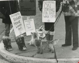
BC Government Employees Union - "On Strike for Fair Wage Offer"
https://search.heritageburnaby.ca/link/archivedescription59050
- Repository
- City of Burnaby Archives
- Date
- ca.1983
- Collection/Fonds
- Columbian Newspaper collection
- Description Level
- Item
- Physical Description
- 1 photograph : b&w ; 20.5 x 25.5 cm
- Scope and Content
- Photograph of the legs of demonstrators and two dogs at a BC Government Employees' Union strike.
- Repository
- City of Burnaby Archives
- Date
- ca.1983
- Collection/Fonds
- Columbian Newspaper collection
- Physical Description
- 1 photograph : b&w ; 20.5 x 25.5 cm
- Description Level
- Item
- Record No.
- 480-1456
- Access Restriction
- No restrictions
- Reproduction Restriction
- Reproduce for fair dealing purposes only
- Accession Number
- 2009-01
- Scope and Content
- Photograph of the legs of demonstrators and two dogs at a BC Government Employees' Union strike.
- Media Type
- Photograph
- Photographer
- King, Basil
- Notes
- Title based on contents of photograph
- Photographer's stamp on verso
Images
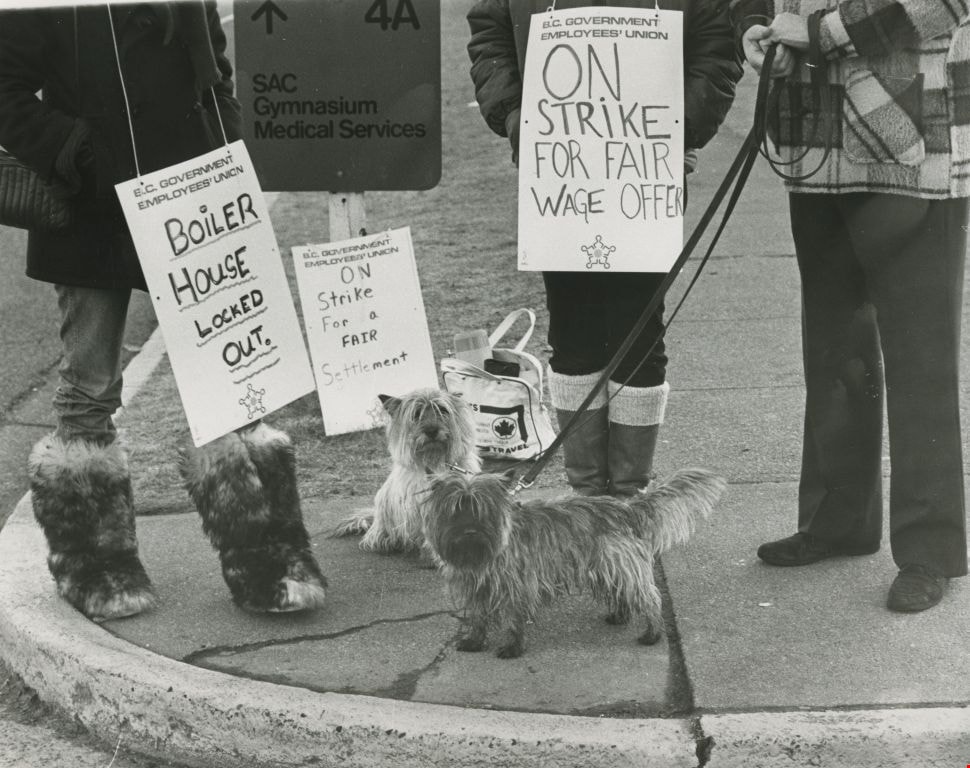
BC Government Employees Union - "On Strike for Fair Wage Offer"
https://search.heritageburnaby.ca/link/archivedescription59051
- Repository
- City of Burnaby Archives
- Date
- ca.1983
- Collection/Fonds
- Columbian Newspaper collection
- Description Level
- Item
- Physical Description
- 1 photograph : b&w ; 20.5 x 25.5 cm
- Scope and Content
- Photograph of BC Government Employees Union strikers standing by the roadside as a car drives by. The photograph is from Burnaby Today.
- Repository
- City of Burnaby Archives
- Date
- ca.1983
- Collection/Fonds
- Columbian Newspaper collection
- Physical Description
- 1 photograph : b&w ; 20.5 x 25.5 cm
- Description Level
- Item
- Record No.
- 480-1457
- Access Restriction
- No restrictions
- Reproduction Restriction
- Reproduce for fair dealing purposes only
- Accession Number
- 2009-01
- Scope and Content
- Photograph of BC Government Employees Union strikers standing by the roadside as a car drives by. The photograph is from Burnaby Today.
- Media Type
- Photograph
- Photographer
- King, Basil
- Notes
- Title based on contents of photograph
- Photographer's stamp on verso
Images
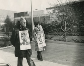
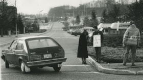
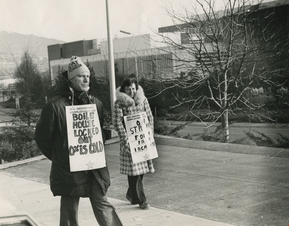
BC Government Employees Union - "On Strike for Fair Wage Offer"
https://search.heritageburnaby.ca/link/archivedescription59052
- Repository
- City of Burnaby Archives
- Date
- ca.1983
- Collection/Fonds
- Columbian Newspaper collection
- Description Level
- Item
- Physical Description
- 1 photograph : b&w ; 20.5 x 25.5 cm
- Scope and Content
- Photograph of two BC Government Employees Union strikers walking outdoors. The photograph is from Burnaby Today.
- Repository
- City of Burnaby Archives
- Date
- ca.1983
- Collection/Fonds
- Columbian Newspaper collection
- Physical Description
- 1 photograph : b&w ; 20.5 x 25.5 cm
- Description Level
- Item
- Record No.
- 480-1458
- Access Restriction
- No restrictions
- Reproduction Restriction
- Reproduce for fair dealing purposes only
- Accession Number
- 2009-01
- Scope and Content
- Photograph of two BC Government Employees Union strikers walking outdoors. The photograph is from Burnaby Today.
- Media Type
- Photograph
- Notes
- Title based on contents of photograph
Images
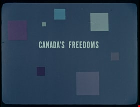
Canada's Freedoms
https://search.heritageburnaby.ca/link/museumlibrary7536
- Repository
- Burnaby Village Museum
- Publication Date
- c1958
- Repository
- Burnaby Village Museum
- Collection
- Special Collection
- Material Type
- Photograph
- Accession Code
- BV016.7.10
- Contributor
- Lunn, John
- Charbonneau, G.
- Donoahue, Jim
- Moller, Hans
- Place of Publication
- Ottawa
- Publisher
- National Film Board of Canada
- Publication Date
- c1958
- Physical Description
- 24 photographs : filmstrip ; cellulose aacetate, col. pos.
- Library Subject (LOC)
- Documentary Films
- Filmstrips
- Civil rights--Canada
- Subjects
- Rights - Human Rights
- Names
- Oakalla Prison Farm
- Object History
- Came in with Oakalla Prison records and artifacts in 1991. Filmstrip was utilized by staff and inmates of Oakalla. Digitized by BVM into preservation and accessible formats in 2020.
- Notes
- Educational filmstrip with text and illustrations providing a basic explanation on "Canada's Freedoms" from the Canadian Charter of Rights and Freedoms including Freedom of Speech, Freedom of Creative Expression, Freedom of Worship, Freedom of Movement, Freedom of Occupation, Freedom of Association and Freedom of Political Choice.
Images
Documents

Subdivision plans in New Westminster District Group 1 – Burnaby, Vancouver and map - Canada Department of Mines
https://search.heritageburnaby.ca/link/museumdescription6994
- Repository
- Burnaby Village Museum
- Date
- 1890-1909
- Collection/Fonds
- Burnaby Village Museum Map collection
- Description Level
- File
- Physical Description
- 1 plan : graphite on paper + 2 plans : black ink on paper + 1 map : col. on paper mounted on 2 sides of cardboard 76 x 102 cm
- Scope and Content
- Item consists of a large board with one New Westminster District subdivision plan mounted on one side and two New Westminster District subdivision plans and one colour map mounted on the other side. Side A: 1. "Plan / of Subdivision of / Blocks 2, 3, 4, 5, 6 / Lot 77 / Group 1 / New Westminster D…
- Repository
- Burnaby Village Museum
- Collection/Fonds
- Burnaby Village Museum Map collection
- Description Level
- File
- Physical Description
- 1 plan : graphite on paper + 2 plans : black ink on paper + 1 map : col. on paper mounted on 2 sides of cardboard 76 x 102 cm
- Material Details
- Scales 1:720 and 1:1200 and 1:.00001578
- Scope and Content
- Item consists of a large board with one New Westminster District subdivision plan mounted on one side and two New Westminster District subdivision plans and one colour map mounted on the other side. Side A: 1. "Plan / of Subdivision of / Blocks 2, 3, 4, 5, 6 / Lot 77 / Group 1 / New Westminster District / BC. / Scale 100 feet = 1 inch", "Deposited 8th day / of April 1890 / Mowileg [sic] / Dist. Regt". Plan is drawn in graphite with annotations: "AB_Parts_lettered_are_lots_in / the_different_subdivisions" / "Owners: / James E. Hall / P.S.Cabilan [sic] by his attorney Joseph Hall / Joseph Hall / Eliza J. Shannon / John Harrison"; "This plan is correct and is prepared under the / provisions of the Land Registry Act" ; signed by: "Gordon Herman & Burwell / Dominion & Provincial Land Surveryors / Vancouver March 19th/90" . Plan is initialed by: "RB" [sic] (in blue pencil crayon) and measures: 99.5 x 65 cm (Geographic location: Burnaby) Side B: 1. Map titled "Canada / Department of Mines / Geological Survey Branch" / "Hon.W Templeton, Minister / A.P. Low, Deputy Minister / R.W. Brock, Acting Director", Vol. XXXI, Plate I / Compiled under the direction of / James White, F.R.G.S. Geographer /Dep. of Interior". Note above map reads: "To illustrate Mr. James Barrowman's report as Delegate at the Excursion - meeting of the Canadian Mining Institute", "The instiitution of Mining Engineers / Transactions 1908 - 1909", "The Mining Institute of Scotland / Transactions 1908-1909". Map identifies minerals and includes a Legend and Scale: 100 miles = 1 inch 2. "Plan / of Subdivision of / Lot 4 / of Subdivision of / Lot 87. Gr. 1 / New Westminster District / Scale 60' = 1in." Plan is initialed by: "RB" [sic] along with a note "also Board / 48" (in blue pencil crayon) (Geographic location: Burnaby) 3. Plan of "Lot 335 / G. 1" west of Boundary Road and north of River Road - Vancouver. (Geographic location: Vancouver)
- Publisher
- The Mining Institute of Scotland
- Geographic Access
- Vancouver
- Accession Code
- HV977.93.25
- Access Restriction
- No restrictions
- Reproduction Restriction
- No known restrictions
- Date
- 1890-1909
- Media Type
- Cartographic Material
- Scan Resolution
- 300
- Scale
- 72
- Notes
- Title based on contents of file
- Scale is measured in feet and miles.
- The term "Lot" often refers to "District Lot"
Images


Map of South Western Part of British Columbia
https://search.heritageburnaby.ca/link/museumdescription8688
- Repository
- Burnaby Village Museum
- Date
- 1897
- Collection/Fonds
- Burnaby Village Museum Map collection
- Description Level
- Item
- Physical Description
- 1 map : col. ink on paper ; 68 x 88 cm
- Scope and Content
- Item consists of a "MAP OF THE SOUTH-WESTERN PART OF BRITISH COLUMBIA”. Map identifies geographic land districts of New Westminster District; Coast District; Lillooet District; Yale District, Kamloops Division, Yale Division and districts on Vancouver Island. Map also includes the northern portions…
- Repository
- Burnaby Village Museum
- Collection/Fonds
- Burnaby Village Museum Map collection
- Description Level
- Item
- Physical Description
- 1 map : col. ink on paper ; 68 x 88 cm
- Material Details
- Scale [1:633600]
- Scope and Content
- Item consists of a "MAP OF THE SOUTH-WESTERN PART OF BRITISH COLUMBIA”. Map identifies geographic land districts of New Westminster District; Coast District; Lillooet District; Yale District, Kamloops Division, Yale Division and districts on Vancouver Island. Map also includes the northern portions of the State of Washington below the 49th parallel.
- Publisher
- The Colonist Litho Victoria B.C.
- Responsibility
- Martin, George Bohun
- Accession Code
- BV993.12.12
- Access Restriction
- No restrictions
- Reproduction Restriction
- No known restrictions
- Date
- 1897
- Media Type
- Cartographic Material
- Scan Resolution
- 600
- Scan Date
- 2023-08-17
- Notes
- Transcribed title
- Scale equals 1 inch to 10 miles
- "Compiled and drawn by direction of the Honouable G.B. Martin, Chief Commissioner of Lands and Works, Victoria, B.C."
- Signed by Surveyor General "Tom Kains"
Zoomable Images

, copied 1978 thumbnail](/media/hpo/_Data/_BVM_Images/1977/197800140001.jpg?width=280)
Davidson Spark Arrester
https://search.heritageburnaby.ca/link/museumdescription465
- Repository
- Burnaby Village Museum
- Date
- [190-](date of original), copied 1978
- Collection/Fonds
- Burnaby Village Museum Photograph collection
- Description Level
- Item
- Physical Description
- 1 photograph : b&w ; 20.2 x 25.3 cm print
- Scope and Content
- Photograph documents an advertisement for the Davidson Spark Arrester. On the left side of the advertisement spot is a diagram of the water flow in the arrester. The right side has explanation of the arrester as "the first Arrester to be approved by the Provincial Government authorities." The adve…
- Repository
- Burnaby Village Museum
- Collection/Fonds
- Burnaby Village Museum Photograph collection
- Description Level
- Item
- Physical Description
- 1 photograph : b&w ; 20.2 x 25.3 cm print
- Scope and Content
- Photograph documents an advertisement for the Davidson Spark Arrester. On the left side of the advertisement spot is a diagram of the water flow in the arrester. The right side has explanation of the arrester as "the first Arrester to be approved by the Provincial Government authorities." The advertisement further reads, "It is guaranteed to be 100 PER CENT EFFICIENT as an arrester and does not impede the draught. Water level is maintained automatically and supplied from the injector. NO WIRE SCREENS TO GET GUMMED UP. This arrester is patented, made and guaranteed by VANCOUVER ENGINEERING WORKS Ltd." An annotation on the back of the photograph reads: "Davidson Spark Arrester."
- Subjects
- Advertising Medium
- Accession Code
- HV978.14.1
- Access Restriction
- No restrictions
- Reproduction Restriction
- No known restrictions
- Date
- [190-](date of original), copied 1978
- Media Type
- Photograph
- Scan Resolution
- 600
- Scan Date
- 2023-08-01
- Notes
- Title based on contents of photograph
Images
, copied 1978 thumbnail](/media/hpo/_Data/_BVM_Images/1977/197800140001.jpg)
![Survey and Subdivision plans in New Westminster District Group 2 - Surrey, ʷməθkʷəy̓əm (Musqueam) Indian Reserve, [190-] thumbnail](/media/hpo/_Data/_BVM_Cartographic_Material/1977/1977_0093_0086_001.jpg?width=280)
Survey and Subdivision plans in New Westminster District Group 2 - Surrey, ʷməθkʷəy̓əm (Musqueam) Indian Reserve
https://search.heritageburnaby.ca/link/museumdescription7055
- Repository
- Burnaby Village Museum
- Date
- [190-]
- Collection/Fonds
- Burnaby Village Museum Map collection
- Description Level
- File
- Physical Description
- 12 plans : graphite and ink on paper and linen; various sizes mounted on 2 sides of cardboard 76 x 102 cm
- Scope and Content
- File consists of a large board with twelve plans (six plans mounted on each side). All plans are located in New Westminster District, Group 2, covering geographic areas within Surrey. Side A: 1. Plan : black ink on paper ; 20.5 x 57.5 cm. Title reads: "Extension of Tram Line / Hospital to Distill…
- Repository
- Burnaby Village Museum
- Collection/Fonds
- Burnaby Village Museum Map collection
- Description Level
- File
- Physical Description
- 12 plans : graphite and ink on paper and linen; various sizes mounted on 2 sides of cardboard 76 x 102 cm
- Scope and Content
- File consists of a large board with twelve plans (six plans mounted on each side). All plans are located in New Westminster District, Group 2, covering geographic areas within Surrey. Side A: 1. Plan : black ink on paper ; 20.5 x 57.5 cm. Title reads: "Extension of Tram Line / Hospital to Distillery St." Scales: Hor: 100 feet = 1 inch; Vert: 20 feet = 1 inch. tram line, hospital to distillery street; 2. Plan : black ink on linen ; 55 x 46.5 cm. (no title). Plan covers New Westminster District, Group 2, Lots 1,2, 3,4, A and B and the ʷməθkʷəy̓əm (Musqueam) Indian Reserve (1868).along the south shore of the Fraser River opposite City of New Westminster. Portion of land is highlighted in blue along the west border of the "ʷməθkʷəy̓əm (Musqueam) Indian Reserve" and between Lot 2 and Lot 1 and survey lines identified as "Mohun's Line" and Hill's Line. Stamp in red ink on plan reads: "Albert J. HIll, M.A. / Civil Engineer / and Provincial Land Surveyor / New Westminster / B.C." (Geographic location: Surrey also formerly known as Brownsville) 3. Plan : black ink on paper ; 34.5 x 23 cm. Title reads: "Lot 51, Gr.2" (in blue crayon). Plan covers area in New Westminster, Group 2, District Lot 51, north of Mud Bay with the Victoria Terminal Railway and Great Northern Railway lines identified. (Geographic location: Surrey) 4. Plan : graphite on paper ; 16.5 x 18 cm. Title reads: "Sec.20, B5N R2W" (underlined in blue crayon). Sketch plan covers and area in New Westmninster District, Group 2. Plan includes initials "RB" in blue crayon. Scale: 5 chains = 1 inch (Geographic location: Surrey) 5. Plan : graphite on paper with annotations in black ink ; 17 x 21 cm. Title reads: "N.W.1/4 Sec.12 TP2" (in blue crayon). Plan covers an area in New Westminster District Group 2 in Section 12, south of Bose Road. Identifying land marks include names: "Bose", "Smith" and "Church Land" Scale: 8 chains = 1 inch (Geographic location: Surrey) 6. Plan : graphite on paper ; 38 x 26.5 cm. (no title) Sketch plan covers areas in Lot 1 and Lot 2 with land identified as "Dominion Government". (could be survey for ʷməθkʷəy̓əm (Musqueam) Indian Reserve) (Geographic location: Surrey also formerly known as Brownsville) Side B: 1. Plan: black ink on paper ; 53.5 x 38 cm. Title reads:"Plan of Subdivision / of / Section 27, / Block 5 North, Range 2 West / New Westminster District". Scale: 4 chains = 1 inch. Includes area subdivided into 18 lots, south of Hjorth Road (104th Avenue) and west of Quible Road with Yale Road running through. Note in blue crayon reads: See also Bd.93) (Geographic location: Surrey) 2. Plan : black ink on paper ; 35 x 28 cm. Title reads: "Plan / of / Block A - L387A / Surrey". Scale: 2 chains = 1 inch. Annotaion in blue crayon reads: "Blk A / Lot 387a_Gr. 2". Plan covers New Westminster District Group 2, Block A, Lot 387 A, south of Parsons Slough and east of Latimer Road (192nd Street). Stamp in red ink on plan reads: "Albert J. HIll, M.A. / Civil Engineer / and Provincial Land Surveyor / New Westminster / B.C." (Geographic location: Surrey) 3. Plan : black ink on linen ; 50 x 42 cm. Title reads: Plan / of part of / Campbell River / running through / the South portion / of N.E. 1/4, Section 8, / Tp. 7, East of Coast Meridian / also / Showing location / of Shingle Mill and Dam". Scale: 100 feet = 1 inch. Plan covers the area in New Westminster District, Township 7, Section 8 with Hall's Prairie Road (184th Street) running through and intersecting with Campbell River. Vegetation, buildings, bridge, shingle mill are identified. (Geographic location: Surrey) 5. Plan : black ink on linen ; 21.5 x 16.5 cm. Title reads: "Sec.32, B5N R2W". Scale: 10 chains = 1 inch. Signed by "Albert J. Hill / B.C.L.S. / Dec. 23, 1908". Note on survey reads: "No actual survey / 40 ac. surveyed". (Geographic location: Surrey) 6. Plan : graphite on paper ; 22 x 15.5 cm. Title reads: "Position 'A5' Subjects / by _McKenzie" [Geographic location: Surrey]
- Creator
- Hill, Albert James
- Names
- ʷməθkʷəy̓əm (Musqueam)
- Accession Code
- HV977.93.86
- Access Restriction
- No restrictions
- Reproduction Restriction
- No known restrictions
- Date
- [190-]
- Media Type
- Cartographic Material
- Scan Resolution
- 600
- Scan Date
- 2023-06-26
- Notes
- Title based on contents of file
- Numeric stamp on edge of board reads: "86"
Zoomable Images
![Survey and Subdivision plans in New Westminster District Group 2 - Surrey, ʷməθkʷəy̓əm (Musqueam) Indian Reserve, [190-] thumbnail](/media/hpo/_Data/_BVM_Cartographic_Material/1977/1977_0093_0086_003_seadragon/1977_0093_0086_003.jpg?w=280)
Survey and Subdivision plans in New Westminster District Group 2 - Surrey, ʷməθkʷəy̓əm (Musqueam) Indian Reserve, [190-]
Zoom into Image

Sketch map of the Province of British Columbia showing mining divisions
https://search.heritageburnaby.ca/link/museumdescription18946
- Repository
- Burnaby Village Museum
- Date
- 1907
- Collection/Fonds
- Burnaby Village Museum Map collection
- Description Level
- Item
- Physical Description
- 1 map : col. lithographic print on paper ; 52 x 59 cm
- Scope and Content
- Item consists of a map titled "Sketch map of the Province of / British Columbia / Showing Mining Divisions"; "Department of Mines, / Victoria, 1907". Map includes wagon roads and trails and geographic disticts.
- Repository
- Burnaby Village Museum
- Collection/Fonds
- Burnaby Village Museum Map collection
- Description Level
- Item
- Physical Description
- 1 map : col. lithographic print on paper ; 52 x 59 cm
- Material Details
- Scale not determinable
- Scope and Content
- Item consists of a map titled "Sketch map of the Province of / British Columbia / Showing Mining Divisions"; "Department of Mines, / Victoria, 1907". Map includes wagon roads and trails and geographic disticts.
- Accession Code
- HV977.37.172
- Access Restriction
- No restrictions
- Reproduction Restriction
- No known restrictions
- Date
- 1907
- Media Type
- Cartographic Material
- Scan Resolution
- 600
- Scan Date
- 2023-08-17
- Notes
- Title based on contents of map
- Stamp on verso of map reads: "Compliments of Vancouver Tourist Bureau"
Zoomable Images

![Government Road property, [191-] (date of original), copied 1986 thumbnail](/media/hpo/_Data/_Archives_Images/_Unrestricted/204/204-689.jpg?width=280)
Government Road property
https://search.heritageburnaby.ca/link/archivedescription35830
- Repository
- City of Burnaby Archives
- Date
- [191-] (date of original), copied 1986
- Collection/Fonds
- Burnaby Historical Society fonds
- Description Level
- Item
- Physical Description
- 1 photograph : b&w ; 12.7 x 17.8 cm print
- Scope and Content
- Photograph of (left) James Ker (maternal grandfather), (right) Robert Haddon (father), and Gordon Haddon (son), cutting firewood from a large fallen fir with a Wee MacGregor chainsaw on their Hastings Mill property south of the family home on Government Road.
- Repository
- City of Burnaby Archives
- Date
- [191-] (date of original), copied 1986
- Collection/Fonds
- Burnaby Historical Society fonds
- Subseries
- Pioneer Tales subseries
- Physical Description
- 1 photograph : b&w ; 12.7 x 17.8 cm print
- Description Level
- Item
- Record No.
- 204-689
- Access Restriction
- No restrictions
- Reproduction Restriction
- No restrictions
- Accession Number
- BHS1988-03
- Scope and Content
- Photograph of (left) James Ker (maternal grandfather), (right) Robert Haddon (father), and Gordon Haddon (son), cutting firewood from a large fallen fir with a Wee MacGregor chainsaw on their Hastings Mill property south of the family home on Government Road.
- Subjects
- Land Clearing
- Plants - Trees
- Media Type
- Photograph
- Notes
- Title based on contents of photograph
- Geographic Access
- Government Road
- Historic Neighbourhood
- Lozells (Historic Neighbourhood)
- Planning Study Area
- Government Road Area
Images
![Government Road property, [191-] (date of original), copied 1986 thumbnail](/media/hpo/_Data/_Archives_Images/_Unrestricted/204/204-689.jpg)

Government Docks, New Westminster
https://search.heritageburnaby.ca/link/archivedescription39576
- Repository
- City of Burnaby Archives
- Date
- 1910
- Collection/Fonds
- Peers Family and Hill Family fonds
- Description Level
- Item
- Physical Description
- 1 photograph : b&w ; 7.8 x 10.2 cm on page 21.5 x 28 cm (pasted in album)
- Scope and Content
- Photograph of a boat (the "Vite") pulled up to the Government docks at the foot of 8th Street in New Westminster. Queensborough can be seen in the background. The three men in the boat are unidentified.
- Repository
- City of Burnaby Archives
- Date
- 1910
- Collection/Fonds
- Peers Family and Hill Family fonds
- Physical Description
- 1 photograph : b&w ; 7.8 x 10.2 cm on page 21.5 x 28 cm (pasted in album)
- Description Level
- Item
- Record No.
- 477-895
- Access Restriction
- No restrictions
- Reproduction Restriction
- No known restrictions
- Accession Number
- 2007-12
- Scope and Content
- Photograph of a boat (the "Vite") pulled up to the Government docks at the foot of 8th Street in New Westminster. Queensborough can be seen in the background. The three men in the boat are unidentified.
- Subjects
- Recreational Activities - Boating
- Structures - Piers and Wharves
- Geographic Features - Rivers
- Media Type
- Photograph
- Notes
- Title based on contents of photograph
Images

![Lozells Post Office in Burnaby, [between 1910 and 1913] thumbnail](/media/hpo/_Data/_BVM_Images/1975/1975_0032_0002_001.jpg?width=280)
Lozells Post Office in Burnaby
https://search.heritageburnaby.ca/link/museumdescription898
- Repository
- Burnaby Village Museum
- Date
- [between 1910 and 1913]
- Collection/Fonds
- Burnaby Village Museum Photograph collection
- Description Level
- Item
- Physical Description
- 1 photograph : b&w ; 8.2 x 13.7 cm
- Scope and Content
- Photograph of Lozells Post Office, on the north shore of Burnaby Lake. This two storey house stood at the north eastern corner of the Great Northern tracks and Piper Road. Around the house is a low picket fence, and a large sign that read, "LOZELLS." In 1908, Col. James Ward and his wife, Mrs. War…
- Repository
- Burnaby Village Museum
- Collection/Fonds
- Burnaby Village Museum Photograph collection
- Description Level
- Item
- Physical Description
- 1 photograph : b&w ; 8.2 x 13.7 cm
- Scope and Content
- Photograph of Lozells Post Office, on the north shore of Burnaby Lake. This two storey house stood at the north eastern corner of the Great Northern tracks and Piper Road. Around the house is a low picket fence, and a large sign that read, "LOZELLS." In 1908, Col. James Ward and his wife, Mrs. Ward, came to Lozells and opened a post office. Mrs. Ward named the place Lozells because when she lived in Birmingham England, she was a parishioner in the Anglican Parish of Lozells. (Reference: George Green's "History of Burnaby" p147).
- History
- Mrs. Lozells had lived in Birmingham, England, was a parishoner in the Anglican parish of Lozells in the city. The Graeat Northern Railway laid its tracks through this district [ ] and hwne this rail route was completed the Royal City Mills built a sawmill of considerable size near the foot of Piper Avenue. C.T.W. Pyper and Alfred Wiggs built a small mill nearby and a shipping siding was installed and called Pyper's Siding. (Reference from HIstory of Burnaby by George Green.)
- Subjects
- Buildings - Public - Post Offices
- Accession Code
- HV975.32.2
- Access Restriction
- No restrictions
- Reproduction Restriction
- No known restrictions
- Date
- [between 1910 and 1913]
- Media Type
- Photograph
- Historic Neighbourhood
- Lozells (Historic Neighbourhood)
- Planning Study Area
- Government Road Area
- Scan Resolution
- 600
- Scan Date
- 2023-06-06
- Notes
- Title based on contents of photograph
Images
![Lozells Post Office in Burnaby, [between 1910 and 1913] thumbnail](/media/hpo/_Data/_BVM_Images/1975/1975_0032_0002_001.jpg)
![B.C. Parliament Building in Victoria, [ca. 1920] thumbnail](/media/hpo/_Data/_BVM_Images/1985/1985_5899_0003_001.jpg?width=280)
B.C. Parliament Building in Victoria
https://search.heritageburnaby.ca/link/museumdescription1527
- Repository
- Burnaby Village Museum
- Date
- [ca. 1920]
- Collection/Fonds
- Burnaby Village Museum Photograph collection
- Description Level
- Item
- Physical Description
- 1 photograph : b&w ; 6.5 x 9 cm
- Scope and Content
- Photograph of the British Columbia Parliament Buildings, home of the Legislative Assembly of British Columbia located in Victoria. There are people standing on the steps to the front entrance. There is a sign on the lawn in front of the parliament buliding that reads, "PLEASE KEEP OFF THE GRASS."
- Repository
- Burnaby Village Museum
- Collection/Fonds
- Burnaby Village Museum Photograph collection
- Description Level
- Item
- Physical Description
- 1 photograph : b&w ; 6.5 x 9 cm
- Material Details
- stamped on verso, t. "159"
- Scope and Content
- Photograph of the British Columbia Parliament Buildings, home of the Legislative Assembly of British Columbia located in Victoria. There are people standing on the steps to the front entrance. There is a sign on the lawn in front of the parliament buliding that reads, "PLEASE KEEP OFF THE GRASS."
- Subjects
- Government - Provincial Government
- Geographic Access
- Victoria
- Accession Code
- BV985.5899.3
- Access Restriction
- No restrictions
- Reproduction Restriction
- No known restrictions
- Date
- [ca. 1920]
- Media Type
- Photograph
- Scan Resolution
- 600
- Scan Date
- 2024-02-27
- Notes
- Title based on contents of photograph
Images
![B.C. Parliament Building in Victoria, [ca. 1920] thumbnail](/media/hpo/_Data/_BVM_Images/1985/1985_5899_0003_001.jpg)
![Survey and Subdivision plans in New Westminster District Group 1 and Group 2 – Vancouver, ʷməθkʷəy̓əm (Musqueam) Indian Reserve, Burnaby, Surrey
, [1910-1911] thumbnail](/media/hpo/_Data/_BVM_Cartographic_Material/1977/1977_0093_0017_001.jpg?width=280)
Survey and Subdivision plans in New Westminster District Group 1 and Group 2 – Vancouver, ʷməθkʷəy̓əm (Musqueam) Indian Reserve, Burnaby, Surrey
https://search.heritageburnaby.ca/link/museumdescription6986
- Repository
- Burnaby Village Museum
- Date
- [1910-1911]
- Collection/Fonds
- Burnaby Village Museum Map collection
- Description Level
- File
- Physical Description
- 9 plans : 4 plans : blueprint ink on paper + 4 plans : black ink on paper + 1 plan : graphite on paper mounted on 2 sides of cardboard 76 x 102 cm
- Scope and Content
- File consists of a large board of three survey plans in New Westminster District Group 1 mounted on one side and six survey and subdivision plans of District Lot 85, New Westminster District Group 1 mounted on the other side. Side A: 1. Plan : blueprint on paper ; 30.5 x 80 cm. Title reads: "Fras…
- Repository
- Burnaby Village Museum
- Collection/Fonds
- Burnaby Village Museum Map collection
- Description Level
- File
- Physical Description
- 9 plans : 4 plans : blueprint ink on paper + 4 plans : black ink on paper + 1 plan : graphite on paper mounted on 2 sides of cardboard 76 x 102 cm
- Material Details
- Scales vary (One chain equals 792 inches)
- Indexed number on tape on edge of board reads "17"
- Scope and Content
- File consists of a large board of three survey plans in New Westminster District Group 1 mounted on one side and six survey and subdivision plans of District Lot 85, New Westminster District Group 1 mounted on the other side. Side A: 1. Plan : blueprint on paper ; 30.5 x 80 cm. Title reads: "Fraser River Bridge / Plan of South Approach". Plan covers area of land north of the Fraser River and Great Northern Railway with approach for a bridge running through the "ʷməθkʷəy̓əm (Musqueam) Indian Reserve" (ʷməθkʷəy̓əm (Musqueam) First Nation) and lots marked as Dominion Government and the east half of Lot 2 identified as "C. F. Brown" "Plan 851". Plan is identified as "Plan 851 / traced / Mar. 17, 1911". (Geographic location in Vancouver) Scale: 100 feet = 1 inch, Signed by Albert J. Hill / P.L.S." 2. Plan : blueprint on paper ; 36.5 x 35 cm (no title). Includes three plans of lots on the east and west sides of North Road. Note on bottom of blueprint reads: "I.E.B. McKay Surveyor General - hereby certify / that this is a correct tracing from the field / notes of the Royal Engineers on file in the / Lands Department / E.B. McKay (signature) / Surveyor General / Victoria B.C. April 11th 1911" . Plan in top left titled "Page 11 / Vol. 1. / R.E. Notes" covers District Lots east of North Road including Lot 5, Lot 7, Lot 41, Lot 9 and Lot 107 in Coquitlam. Plan in top right corner titled "Page 17 / Vol. 1. / R.E. Notes" covers District Lots east of North Road including Lot 104, Lot 54, Lot 105, Lot 55, Lot 106, Lot 9 and Lot 107 in Coquitlam and Port Moody. Plan in lower left corner titled "Page 15 / Vol. 1 / R.E. Notes" covers District Lots west of North Road including Lot 147, Lot 148, Lot 100, Lot 15 in Burnaby. 3. Plan : blue print on paper ; 29.5 x 41.5 cm. (no formal title). Plan of the North 1/2 of Section 18. Plan covers area in the "North 1/2 of Sec.18 B.5 N RGE 1 W" and "Sec. 18 B.5 N. RGE 1 W" bordered by Section 7, Section 13, Section 17 and Section 19. Bon Accord Road runs through Sec. 18. The plan is signed by surveryor "I.H. Neville Smith... C.E.B.C.L.S. / Mar. 26th 1910" and signed by "Ludwig Pillath". (Geographic location: Surrey) Side B: 1. Plan : blueprint on paper ; 43.5 x 49.5 cm. Title reads: "Plan / of Subdivision / of a Portion / of / Lot 85 / Group One / New Westminster District. Plan covers portion of land east of Deer Lake and Pole Line Road (Sperling Avenue) and south of Hastings Road in District Lot 85 in Burnaby with section 4 and a portion of section 2 coloured in red. Plan is signed by "Albert J. Hill, B.C.L.S." Plan is initialed by: "RB" [sic] (in blue pencil crayon) Scale: 4 chains = 1 inch 2. Plaln : black black ink on linen ; 39 x 37 cm. Title reads: "L.C. Hill's Property, / Burnaby". Plan covers a triangular portion of land east of Pole Line Road (Sperling Avenue) and south of Hastings Road in District Lot 85 in Burnaby. Plan is intitaled by "RB" [sic] (in blue pencil crayon). Scale: 3 chains = 1 mile 3. Plan : graphite on paper ; 23 x 17 cm. Title reads: "Portion of Lot 85 / Gr.1". Plan covers portion of land north east of Deer Lake and west of Pole Line Road (now Sperling Avenue) in District Lot 85 in Burnaby. Plan is stamped in red ink: "Albert J. Hill, Civil Engineer". Plan is initialed by: "RB" [sic] (in blue pencil crayon). Scale: 1 chain = 1 inch 4. Plan : black ink on linen ; 16 x 19 cm. Title reads: "Lot 85". Plan covers the intersection of Pole Line Road (Sperling Avenue) and Hastings Road at the north west section of District Lot 79 and District Lot 85 in Burnaby. Plan is stamped: "A.J. Hill, Civil Engineer" with identitifed in blue pencil crayon. 5. Plan : black ink on paper ; 28.5 x 37 cm. (no formal title) Plan covers an area of land, west of Pole Line Road (Sperling Avenue) and south of Deer Lake in District Lot 85 in Burnaby. Plan is initialed by: "RB" [sic] (in blue pencil crayon) 6. Plan : black ink on paper ; 21 x 34 cm (no formal title). Plan covers an area of land, west of Pole Line Road (Sperling Avenue) and south of Deer Lake in District Lot 85 in Burnaby. Plan is initialed by: "RB" [sic] (in blue pencil crayon)
- Accession Code
- HV977.93.17
- Access Restriction
- No restrictions
- Reproduction Restriction
- No known restrictions
- Date
- [1910-1911]
- Media Type
- Cartographic Material
- Historic Neighbourhood
- Burnaby Lake (Historic Neighbourhood)
- Burquitlam (Historic Neighbourhood)
- Planning Study Area
- Morley-Buckingham Area
- Douglas-Gilpin Area
- Scan Resolution
- 600
- Scan Date
- 2023-06-26
- Notes
- Title based on contents of file
- Scale is measured in chains and feet. (One chain equals 792 inches).
- The term "Lot" also refers to a "District Lot”
- Some plans are stamped: "Albert J. Hill, Civil Engineer / and / Provincial Land Surveyor, / New Westminster, / B.C." and intialed: "RB" [sic]
Zoomable Images
![Survey and Subdivision plans in New Westminster District Group 1 and Group 2 – Vancouver, ʷməθkʷəy̓əm (Musqueam) Indian Reserve, Burnaby, Surrey
, [1910-1911] thumbnail](/media/hpo/_Data/_BVM_Cartographic_Material/1977/1977_0093_0017_003_seadragon/1977_0093_0017_003.jpg?w=280)
Survey and Subdivision plans in New Westminster District Group 1 and Group 2 – Vancouver, ʷməθkʷəy̓əm (Musqueam) Indian Reserve, Burnaby, Surrey , [1910-1911]
Zoom into Image

Government Road
https://search.heritageburnaby.ca/link/archivedescription35567
- Repository
- City of Burnaby Archives
- Date
- 1912 (date of original), copied 1986
- Collection/Fonds
- Burnaby Historical Society fonds
- Description Level
- Item
- Physical Description
- 1 photograph : b&w ; 12.7 x 17.8 cm print
- Scope and Content
- Photograph looking east on Government Road from the Haddon family house. One of the men in the photo is Robert Haddon. The other two people are unidentified. Note the loose gravel roadway and the bridge over Eagle Creek.
- Repository
- City of Burnaby Archives
- Date
- 1912 (date of original), copied 1986
- Collection/Fonds
- Burnaby Historical Society fonds
- Subseries
- Pioneer Tales subseries
- Physical Description
- 1 photograph : b&w ; 12.7 x 17.8 cm print
- Description Level
- Item
- Record No.
- 204-425
- Access Restriction
- No restrictions
- Reproduction Restriction
- No known restrictions
- Accession Number
- BHS1988-03
- Scope and Content
- Photograph looking east on Government Road from the Haddon family house. One of the men in the photo is Robert Haddon. The other two people are unidentified. Note the loose gravel roadway and the bridge over Eagle Creek.
- Names
- Haddon, Robert
- Media Type
- Photograph
- Notes
- Title based on contents of photograph
- Geographic Access
- Eagle Creek
- Government Road
- Historic Neighbourhood
- Lozells (Historic Neighbourhood)
- Planning Study Area
- Government Road Area
Images

![J.E. and Hephezebah Ward, [1912] (date of original) thumbnail](/media/hpo/_Data/_Archives_Images/_Unrestricted/251/312-001.jpg?width=280)
J.E. and Hephezebah Ward
https://search.heritageburnaby.ca/link/archivedescription36626
- Repository
- City of Burnaby Archives
- Date
- [1912] (date of original)
- Collection/Fonds
- Burnaby Historical Society fonds
- Description Level
- Item
- Physical Description
- 1 photograph : b&w ; 12.5 x 8.5 cm print
- Scope and Content
- Photograph of Lieutenant Colonel James E. Ward standing next to his wife Hephzebah, who is sitting in a wicker chair outside on the front porch. They look to be on the porch of the Lozells Post Office at the north eastern corner of the Great Northern tracks and Piper Road. In 1908 the couple came t…
- Repository
- City of Burnaby Archives
- Date
- [1912] (date of original)
- Collection/Fonds
- Burnaby Historical Society fonds
- Subseries
- Richard Hardy family subseries
- Physical Description
- 1 photograph : b&w ; 12.5 x 8.5 cm print
- Description Level
- Item
- Record No.
- 312-001
- Access Restriction
- No restrictions
- Reproduction Restriction
- No known restrictions
- Accession Number
- BHS1993-09
- Scope and Content
- Photograph of Lieutenant Colonel James E. Ward standing next to his wife Hephzebah, who is sitting in a wicker chair outside on the front porch. They look to be on the porch of the Lozells Post Office at the north eastern corner of the Great Northern tracks and Piper Road. In 1908 the couple came to Burnaby and opened the post office (naming it Lozells because when they lived in Birmingham England, Hepezebah was a parishioner in the Anglican Parish of Lozells).
- Media Type
- Photograph
- Notes
- Title based on contents of photograph
- Historic Neighbourhood
- Lozells (Historic Neighbourhood)
- Planning Study Area
- Government Road Area
Images
![J.E. and Hephezebah Ward, [1912] (date of original) thumbnail](/media/hpo/_Data/_Archives_Images/_Unrestricted/251/312-001.jpg)
![Richard and Edith Hardy, [1912] (date of original) thumbnail](/media/hpo/_Data/_Archives_Images/_Unrestricted/251/312-003.jpg?width=280)
Richard and Edith Hardy
https://search.heritageburnaby.ca/link/archivedescription36628
- Repository
- City of Burnaby Archives
- Date
- [1912] (date of original)
- Collection/Fonds
- Burnaby Historical Society fonds
- Description Level
- Item
- Physical Description
- 1 photograph : b&w ; 12.5 x 8.5 cm print
- Scope and Content
- Photograph of Richard and Edith Hardy standing inside a fenced yard. Edith has her arms around Richard's shoulders. They are most likely at the Lozells Post Office at the north eastern corner of the Great Northern tracks and Piper Road. In 1908, Col. James Ward and his wife Hepezebah came to Burna…
- Repository
- City of Burnaby Archives
- Date
- [1912] (date of original)
- Collection/Fonds
- Burnaby Historical Society fonds
- Subseries
- Richard Hardy family subseries
- Physical Description
- 1 photograph : b&w ; 12.5 x 8.5 cm print
- Description Level
- Item
- Record No.
- 312-003
- Access Restriction
- No restrictions
- Reproduction Restriction
- No known restrictions
- Accession Number
- BHS1993-09
- Scope and Content
- Photograph of Richard and Edith Hardy standing inside a fenced yard. Edith has her arms around Richard's shoulders. They are most likely at the Lozells Post Office at the north eastern corner of the Great Northern tracks and Piper Road. In 1908, Col. James Ward and his wife Hepezebah came to Burnaby and opened the post office (naming it Lozells because when they lived in Birmingham England, Hepezebah was a parishioner in the Anglican Parish of Lozells).
- Names
- Hardy, Richard
- Hardy, Edith
- Media Type
- Photograph
- Notes
- Title based on contents of photograph
- Historic Neighbourhood
- Lozells (Historic Neighbourhood)
- Planning Study Area
- Government Road Area
Images
![Richard and Edith Hardy, [1912] (date of original) thumbnail](/media/hpo/_Data/_Archives_Images/_Unrestricted/251/312-003.jpg)
![Ward family, [1912] (date of original) thumbnail](/media/hpo/_Data/_Archives_Images/_Unrestricted/251/312-004.jpg?width=280)
Ward family
https://search.heritageburnaby.ca/link/archivedescription36629
- Repository
- City of Burnaby Archives
- Date
- [1912] (date of original)
- Collection/Fonds
- Burnaby Historical Society fonds
- Description Level
- Item
- Physical Description
- 1 photograph : b&w ; 8 x 12.5 cm print
- Scope and Content
- Photograph of the Ward Family, including children and grandchildren sitting outside. They are most likely on the porch of the Lozells Post Office at the north eastern corner of the Great Northern tracks and Piper Road. In 1908, Col. James Ward and his wife Hepezebah came to Burnaby and opened the p…
- Repository
- City of Burnaby Archives
- Date
- [1912] (date of original)
- Collection/Fonds
- Burnaby Historical Society fonds
- Subseries
- Richard Hardy family subseries
- Physical Description
- 1 photograph : b&w ; 8 x 12.5 cm print
- Description Level
- Item
- Record No.
- 312-004
- Access Restriction
- No restrictions
- Reproduction Restriction
- No known restrictions
- Accession Number
- BHS1993-09
- Scope and Content
- Photograph of the Ward Family, including children and grandchildren sitting outside. They are most likely on the porch of the Lozells Post Office at the north eastern corner of the Great Northern tracks and Piper Road. In 1908, Col. James Ward and his wife Hepezebah came to Burnaby and opened the post office (naming it Lozells because when they lived in Birmingham England, Hepezebah was a parishioner in the Anglican Parish of Lozells).
- Media Type
- Photograph
- Notes
- Title based on contents of photograph
- Historic Neighbourhood
- Lozells (Historic Neighbourhood)
- Planning Study Area
- Government Road Area
Images
![Ward family, [1912] (date of original) thumbnail](/media/hpo/_Data/_Archives_Images/_Unrestricted/251/312-004.jpg)

Family and political photograph album
https://search.heritageburnaby.ca/link/museumdescription3654
- Repository
- Burnaby Village Museum
- Date
- 1914-1977
- Collection/Fonds
- Harold Edward Winch collection
- Description Level
- Item
- Physical Description
- 1 album (ca. 85 photographs)
- Scope and Content
- Item is a photograph album containing ca. 85 photographs, including both personal and work-related subjects such as the Winch family and homes, and Winch's political work and travels. Also included are some textual records relating to Winch's political work.
- Repository
- Burnaby Village Museum
- Collection/Fonds
- Harold Edward Winch collection
- Description Level
- Item
- Physical Description
- 1 album (ca. 85 photographs)
- Scope and Content
- Item is a photograph album containing ca. 85 photographs, including both personal and work-related subjects such as the Winch family and homes, and Winch's political work and travels. Also included are some textual records relating to Winch's political work.
- Names
- Winch, Harold Edward
- Winch, Linda Marian Hendy
- Winch, Grace
- Winch, Eileen
- Winch, Ernest "Ernie"
- Winch, Eric
- Co-operative Commonwealth Federation "CCF"
- New Democratic Party
- Douglas, Tommy
- MacInnis, Grace
- Accession Code
- BV013.12.11
- Date
- 1914-1977
- Media Type
- Photograph
- Textual Record
- Notes
- Title based on contents of photograph
- A selection of photographs from scrapbook have been described at item level (BV013.12.36 to BV015.35.117)
Images

Documents

Haddon family home
https://search.heritageburnaby.ca/link/archivedescription35564
- Repository
- City of Burnaby Archives
- Date
- 1919 (date of original), copied 1986
- Collection/Fonds
- Burnaby Historical Society fonds
- Description Level
- Item
- Physical Description
- 1 photograph : b&w ; 12.7 x 17.8 cm print
- Scope and Content
- Photograph of the Haddon family home at 7870 Government Road between Lozells Avenue and Piper Avenue. Three adults and a young child are standing in at the front door.
- Repository
- City of Burnaby Archives
- Date
- 1919 (date of original), copied 1986
- Collection/Fonds
- Burnaby Historical Society fonds
- Subseries
- Pioneer Tales subseries
- Physical Description
- 1 photograph : b&w ; 12.7 x 17.8 cm print
- Description Level
- Item
- Record No.
- 204-422
- Access Restriction
- No restrictions
- Reproduction Restriction
- No known restrictions
- Accession Number
- BHS1988-03
- Scope and Content
- Photograph of the Haddon family home at 7870 Government Road between Lozells Avenue and Piper Avenue. Three adults and a young child are standing in at the front door.
- Subjects
- Buildings - Residential - Houses
- Media Type
- Photograph
- Notes
- Title based on contents of photograph
- Geographic Access
- Government Road
- Street Address
- 7870 Government Road
- Historic Neighbourhood
- Lozells (Historic Neighbourhood)
- Planning Study Area
- Government Road Area
Images
