Narrow Results By
Subject
- Aerial Photographs 1
- Agriculture - Farms 1
- Animals - Dogs 1
- Buildings - Industrial 1
- Buildings - Industrial - Refineries 1
- Buildings - Residential - Houses 2
- Clothing 1
- Events - Parades 5
- Geographic Features - Automobile Parking Lots 1
- Geographic Features - Bogs 1
- Geographic Features - Rivers 1
- Geographic Features - Roads 2
Creator
- Bancroft, Rose 1
- Bolton, Richard 1
- British Columbia Government Photograph 1
- Burnaby Art Gallery 1
- City of Burnaby 2
- Commercial Illustrators Industrial Photographers 1
- Industrial Photographers 1
- MacSorley, Charles W. 1
- Outram, George 5
- Simnett, Hazel 1
- South Burnaby Garden Club 1
- Stride, Charles Edgar 1

Government Docks, New Westminster
https://search.heritageburnaby.ca/link/archivedescription39576
- Repository
- City of Burnaby Archives
- Date
- 1910
- Collection/Fonds
- Peers Family and Hill Family fonds
- Description Level
- Item
- Physical Description
- 1 photograph : b&w ; 7.8 x 10.2 cm on page 21.5 x 28 cm (pasted in album)
- Scope and Content
- Photograph of a boat (the "Vite") pulled up to the Government docks at the foot of 8th Street in New Westminster. Queensborough can be seen in the background. The three men in the boat are unidentified.
- Repository
- City of Burnaby Archives
- Date
- 1910
- Collection/Fonds
- Peers Family and Hill Family fonds
- Physical Description
- 1 photograph : b&w ; 7.8 x 10.2 cm on page 21.5 x 28 cm (pasted in album)
- Description Level
- Item
- Record No.
- 477-895
- Access Restriction
- No restrictions
- Reproduction Restriction
- No known restrictions
- Accession Number
- 2007-12
- Scope and Content
- Photograph of a boat (the "Vite") pulled up to the Government docks at the foot of 8th Street in New Westminster. Queensborough can be seen in the background. The three men in the boat are unidentified.
- Subjects
- Recreational Activities - Boating
- Structures - Piers and Wharves
- Geographic Features - Rivers
- Media Type
- Photograph
- Notes
- Title based on contents of photograph
Images


Government Road
https://search.heritageburnaby.ca/link/archivedescription35567
- Repository
- City of Burnaby Archives
- Date
- 1912 (date of original), copied 1986
- Collection/Fonds
- Burnaby Historical Society fonds
- Description Level
- Item
- Physical Description
- 1 photograph : b&w ; 12.7 x 17.8 cm print
- Scope and Content
- Photograph looking east on Government Road from the Haddon family house. One of the men in the photo is Robert Haddon. The other two people are unidentified. Note the loose gravel roadway and the bridge over Eagle Creek.
- Repository
- City of Burnaby Archives
- Date
- 1912 (date of original), copied 1986
- Collection/Fonds
- Burnaby Historical Society fonds
- Subseries
- Pioneer Tales subseries
- Physical Description
- 1 photograph : b&w ; 12.7 x 17.8 cm print
- Description Level
- Item
- Record No.
- 204-425
- Access Restriction
- No restrictions
- Reproduction Restriction
- No known restrictions
- Accession Number
- BHS1988-03
- Scope and Content
- Photograph looking east on Government Road from the Haddon family house. One of the men in the photo is Robert Haddon. The other two people are unidentified. Note the loose gravel roadway and the bridge over Eagle Creek.
- Names
- Haddon, Robert
- Media Type
- Photograph
- Notes
- Title based on contents of photograph
- Geographic Access
- Eagle Creek
- Government Road
- Historic Neighbourhood
- Lozells (Historic Neighbourhood)
- Planning Study Area
- Government Road Area
Images

![Government Road property, [191-] (date of original), copied 1986 thumbnail](/media/hpo/_Data/_Archives_Images/_Unrestricted/204/204-689.jpg?width=280)
Government Road property
https://search.heritageburnaby.ca/link/archivedescription35830
- Repository
- City of Burnaby Archives
- Date
- [191-] (date of original), copied 1986
- Collection/Fonds
- Burnaby Historical Society fonds
- Description Level
- Item
- Physical Description
- 1 photograph : b&w ; 12.7 x 17.8 cm print
- Scope and Content
- Photograph of (left) James Ker (maternal grandfather), (right) Robert Haddon (father), and Gordon Haddon (son), cutting firewood from a large fallen fir with a Wee MacGregor chainsaw on their Hastings Mill property south of the family home on Government Road.
- Repository
- City of Burnaby Archives
- Date
- [191-] (date of original), copied 1986
- Collection/Fonds
- Burnaby Historical Society fonds
- Subseries
- Pioneer Tales subseries
- Physical Description
- 1 photograph : b&w ; 12.7 x 17.8 cm print
- Description Level
- Item
- Record No.
- 204-689
- Access Restriction
- No restrictions
- Reproduction Restriction
- No restrictions
- Accession Number
- BHS1988-03
- Scope and Content
- Photograph of (left) James Ker (maternal grandfather), (right) Robert Haddon (father), and Gordon Haddon (son), cutting firewood from a large fallen fir with a Wee MacGregor chainsaw on their Hastings Mill property south of the family home on Government Road.
- Subjects
- Land Clearing
- Plants - Trees
- Media Type
- Photograph
- Notes
- Title based on contents of photograph
- Geographic Access
- Government Road
- Historic Neighbourhood
- Lozells (Historic Neighbourhood)
- Planning Study Area
- Government Road Area
Images
![Government Road property, [191-] (date of original), copied 1986 thumbnail](/media/hpo/_Data/_Archives_Images/_Unrestricted/204/204-689.jpg)
![Freeway at the Willingdon Avenue exit, [1955] thumbnail](/media/hpo/_Data/_Archives_Images/_Unrestricted/480/480-283.jpg?width=280)
Freeway at the Willingdon Avenue exit
https://search.heritageburnaby.ca/link/archivedescription45388
- Repository
- City of Burnaby Archives
- Date
- [1955]
- Collection/Fonds
- Columbian Newspaper collection
- Description Level
- Item
- Physical Description
- 1 photograph : b&w ; 20 x 24.5 cm
- Scope and Content
- Photograph of the Freeway, now named the Trans Canada Highway, near the Willingdon Avenue exit.
- Repository
- City of Burnaby Archives
- Date
- [1955]
- Collection/Fonds
- Columbian Newspaper collection
- Physical Description
- 1 photograph : b&w ; 20 x 24.5 cm
- Description Level
- Item
- Record No.
- 480-283
- Access Restriction
- No restrictions
- Reproduction Restriction
- No restrictions
- Accession Number
- 2003-02
- Scope and Content
- Photograph of the Freeway, now named the Trans Canada Highway, near the Willingdon Avenue exit.
- Subjects
- Geographic Features - Roads
- Media Type
- Photograph
- Photographer
- British Columbia Government Photograph
- Notes
- Title based on contents of photograph
- Photographer identifies photograph as no. H - 1869
- Geographic Access
- Trans Canada Highway
- Willingdon Avenue
- Historic Neighbourhood
- Broadview (Historic Neighbourhood)
- Planning Study Area
- Cascade-Schou Area
Images
![Freeway at the Willingdon Avenue exit, [1955] thumbnail](/media/hpo/_Data/_Archives_Images/_Unrestricted/480/480-283.jpg)
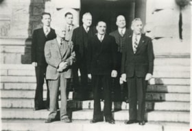
CCF Opposition Members
https://search.heritageburnaby.ca/link/archivedescription35647
- Repository
- City of Burnaby Archives
- Date
- 1951
- Collection/Fonds
- Burnaby Historical Society fonds
- Description Level
- Item
- Physical Description
- 1 photograph : b&w ; 12.7 x 17.8 cm print
- Scope and Content
- Photograph of the CCF (Co-operative Commonwealth Federation) opposition members of the B.C. Legislature. Front row, left to right: Ernie Winch (MLA), Harold Winch (MLA), and Arthur Turner (MLA). Back, left to right: Ran Harding (MLA), Frank Calder (MLA), Rupert Haggen (MLA), and Leo Nimsick, Vict…
- Repository
- City of Burnaby Archives
- Date
- 1951
- Collection/Fonds
- Burnaby Historical Society fonds
- Subseries
- Pioneer Tales subseries
- Physical Description
- 1 photograph : b&w ; 12.7 x 17.8 cm print
- Description Level
- Item
- Record No.
- 204-505
- Access Restriction
- No restrictions
- Reproduction Restriction
- Reproduce for fair dealing purposes only
- Accession Number
- BHS1988-03
- Scope and Content
- Photograph of the CCF (Co-operative Commonwealth Federation) opposition members of the B.C. Legislature. Front row, left to right: Ernie Winch (MLA), Harold Winch (MLA), and Arthur Turner (MLA). Back, left to right: Ran Harding (MLA), Frank Calder (MLA), Rupert Haggen (MLA), and Leo Nimsick, Victoria. Ernie Winch was Leader of the Opposition. He and his son, Harold Winch, set a Guinness world record for the longest father-and-son parliamentary tenure. Frank Calder was the First Status Indian elected to the Legislature.
- Names
- Calder, Frank
- Haggen, Rupert
- Harding, Ran
- Nimsick, Leo
- Turner, Arthur
- Winch, Ernest "Ernie"
- Winch, Harold Edward
- Media Type
- Photograph
- Notes
- Title based on contents of photograph
Images


Haddon family home
https://search.heritageburnaby.ca/link/archivedescription35564
- Repository
- City of Burnaby Archives
- Date
- 1919 (date of original), copied 1986
- Collection/Fonds
- Burnaby Historical Society fonds
- Description Level
- Item
- Physical Description
- 1 photograph : b&w ; 12.7 x 17.8 cm print
- Scope and Content
- Photograph of the Haddon family home at 7870 Government Road between Lozells Avenue and Piper Avenue. Three adults and a young child are standing in at the front door.
- Repository
- City of Burnaby Archives
- Date
- 1919 (date of original), copied 1986
- Collection/Fonds
- Burnaby Historical Society fonds
- Subseries
- Pioneer Tales subseries
- Physical Description
- 1 photograph : b&w ; 12.7 x 17.8 cm print
- Description Level
- Item
- Record No.
- 204-422
- Access Restriction
- No restrictions
- Reproduction Restriction
- No known restrictions
- Accession Number
- BHS1988-03
- Scope and Content
- Photograph of the Haddon family home at 7870 Government Road between Lozells Avenue and Piper Avenue. Three adults and a young child are standing in at the front door.
- Subjects
- Buildings - Residential - Houses
- Media Type
- Photograph
- Notes
- Title based on contents of photograph
- Geographic Access
- Government Road
- Street Address
- 7870 Government Road
- Historic Neighbourhood
- Lozells (Historic Neighbourhood)
- Planning Study Area
- Government Road Area
Images

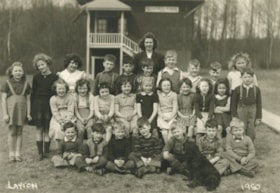
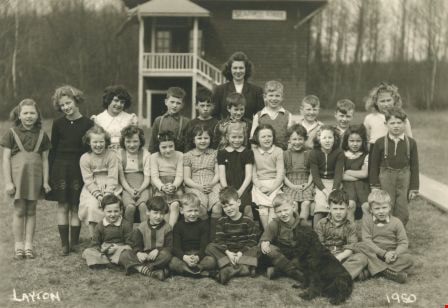
Seaforth School Class
https://search.heritageburnaby.ca/link/archivedescription37341
- Repository
- City of Burnaby Archives
- Date
- 1950
- Collection/Fonds
- Burnaby Historical Society fonds
- Description Level
- Item
- Physical Description
- 1 photograph : b&w ; 12.5 x 17.7 cm
- Scope and Content
- Photograph of twenty-seven students and their teacher seated and standing in rows in front of the school building. A black dog is sitting in the front, facing the rows of children. A label on the back of the photograph states that the students are from Seaforth School. Identified in the photograp…
- Repository
- City of Burnaby Archives
- Date
- 1950
- Collection/Fonds
- Burnaby Historical Society fonds
- Subseries
- Seaforth School subseries
- Physical Description
- 1 photograph : b&w ; 12.5 x 17.7 cm
- Description Level
- Item
- Record No.
- 355-005
- Access Restriction
- No restrictions
- Reproduction Restriction
- Reproduce for fair dealing purposes only
- Accession Number
- BHS1997-14
- Scope and Content
- Photograph of twenty-seven students and their teacher seated and standing in rows in front of the school building. A black dog is sitting in the front, facing the rows of children. A label on the back of the photograph states that the students are from Seaforth School. Identified in the photograph are: Mrs. Mary Johnson (nee MacDonald) teacher, in the far back. Back row (l to r): Sandra ?, Shirley Colden, Marcia Noel, Eldon Clarke, Billy Beaton, David Park, Graeme Smith, Calvert Broomfield, Leigh Tucker and Lillian Savage. Middle row (l to r): Sharon Milne, Gail Simpson, Thelma Mornes, Joan Dachiuk, Barbara Smith, Betty Hadfield, Judy Haddon, Wilma Heather, Merle Beaton and Sammy Savage. Front row (l to r): Dennis Dachiuk, Jerry Hadfield, Mike Lawrence, David MacPhail, Sydney Clarke, Joe Haddon and Jerry Green.
- Subjects
- Animals - Dogs
- Occupations - Teachers
- Names
- Seaforth School
- Johnson, Mary MacDonald
- Colden, Shirley
- Noel, Marcia
- Clarke, Eldon
- Beaton, Billy
- Park, David
- Smith, Graeme
- Broomfield, Calvert
- Tucker, Leigh
- Savage, Lillian
- Anderson, Gail
- Sampson, Gail
- Mornes, Thelma
- Dachiuk, Joan
- Smith, Barbara
- Hadfield, Betty
- Haddon, Judy
- Heather, Wilma
- Beaton, Merle
- Savage, Sammy
- Dachiuk, Dennis
- Hadfield, Jerry
- Lawrence, Mike
- MacPhail, David
- Clarke, Sydney
- Haddon, Joe
- Green, Jerry
- Media Type
- Photograph
- Notes
- Title based on label on verso of photograph
- Photographer identified as "Layton"
- Geographic Access
- Government Road
- Deer Lake Avenue
- Street Address
- 7881 Government Road
- 6501 Deer Lake Avenue
- Historic Neighbourhood
- Lozells (Historic Neighbourhood)
- Planning Study Area
- Government Road Area
Images
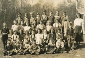
Seaforth School Class
https://search.heritageburnaby.ca/link/archivedescription37342
- Repository
- City of Burnaby Archives
- Date
- 1951
- Collection/Fonds
- Burnaby Historical Society fonds
- Description Level
- Item
- Physical Description
- 1 photograph : b&w ; 12.7 x 17.7 cm
- Scope and Content
- Photograph of twenty-seven students and their teacher seated and standing in rows outside. A label on the back of the photograph states that the students are from Seaforth School. Identified are as follows: Mrs. Mary Johnson (nee MacDonald) teacher, far right. Back row (l to r): Glen Richardson,…
- Repository
- City of Burnaby Archives
- Date
- 1951
- Collection/Fonds
- Burnaby Historical Society fonds
- Subseries
- Seaforth School subseries
- Physical Description
- 1 photograph : b&w ; 12.7 x 17.7 cm
- Description Level
- Item
- Record No.
- 355-006
- Access Restriction
- No restrictions
- Reproduction Restriction
- Reproduce for fair dealing purposes only
- Accession Number
- BHS1997-14
- Scope and Content
- Photograph of twenty-seven students and their teacher seated and standing in rows outside. A label on the back of the photograph states that the students are from Seaforth School. Identified are as follows: Mrs. Mary Johnson (nee MacDonald) teacher, far right. Back row (l to r): Glen Richardson, Leigh Tucker, Brian Clarke, Sammy Savage, Eldon Clarke, David Park, Tommy Richardson, and Joe Haddon. Second row (l to r): Mike Lawrence (standing to the left), Sandra ?, Joan Olsen, Betty Hadfield, Donna Anderson, Wilma Heather, Barbara Smith, Gail Simpson and Shirley Colden. Third row (l to r): Lois Brown, Jackie Peskett, Gail Anderson, Joan Pescott, Merle Beaton, Judy Haddon, Joan Dachiuk, Thelma Mornes, and Jerry Hadfield (standing to the right). Front row (l to r): Dennis Dachiuk, Roy Olsen, David ?, Allen Beaton, Sydney Clarke, David McPhail, and Terry Burstyk.
- Subjects
- Occupations - Teachers
- Names
- Seaforth School
- Johnson, Mary MacDonald
- Richardson, Glen
- Tucker, Leigh
- Clarke, Brian
- Savage, Sammy
- Clarke, Eldon
- Park, David
- Richardson, Tommy
- Haddon, Joe
- Lawrence, Mike
- Olsen, Joan
- Hadfield, Betty
- Anderson, Donna
- Heather, Wilma
- Smith, Barbara
- Sampson, Gail
- Colden, Shirley
- Brown, Lois
- Peskett, Jackie
- Anderson, Gail
- Pescott, Joan
- Beaton, Merle
- Haddon, Judy
- Dachiuk, Joan
- Mornes, Thelma
- Hadfield, Jerry
- Dachiuk, Dennis
- Olsen, Roy
- Beaton, Allen
- Clarke, Sydney
- MacPhail, David
- Burstyk, Terry
- Media Type
- Photograph
- Notes
- Title based on label on verso of photograph
- Photographer identified as "Layton"
- Geographic Access
- Government Road
- Deer Lake Avenue
- Street Address
- 7881 Government Road
- 6501 Deer Lake Avenue
- Historic Neighbourhood
- Lozells (Historic Neighbourhood)
- Planning Study Area
- Government Road Area
Images


Abandonded farm house
https://search.heritageburnaby.ca/link/archivedescription36511
- Repository
- City of Burnaby Archives
- Date
- 1950
- Collection/Fonds
- Burnaby Historical Society fonds
- Description Level
- Item
- Physical Description
- 1 photograph : b&w ; 8.5 x 14 cm
- Scope and Content
- Photograph of an abandoned farm house on Government Road.
- Repository
- City of Burnaby Archives
- Date
- 1950
- Collection/Fonds
- Burnaby Historical Society fonds
- Subseries
- Photographs subseries
- Physical Description
- 1 photograph : b&w ; 8.5 x 14 cm
- Description Level
- Item
- Record No.
- 288-002
- Access Restriction
- No restrictions
- Reproduction Restriction
- Reproduce for fair dealing purposes only
- Accession Number
- BHS1992-23
- Scope and Content
- Photograph of an abandoned farm house on Government Road.
- Media Type
- Photograph
- Notes
- Title based on contents of photograph
- Photograph is a modern contact print of an original negative that was loaned to the Archives
- Geographic Access
- Government Road
- Historic Neighbourhood
- Lochdale (Historic Neighbourhood)
- Planning Study Area
- Government Road Area
Images

![J.E. and Hephezebah Ward, [1912] (date of original) thumbnail](/media/hpo/_Data/_Archives_Images/_Unrestricted/251/312-001.jpg?width=280)
J.E. and Hephezebah Ward
https://search.heritageburnaby.ca/link/archivedescription36626
- Repository
- City of Burnaby Archives
- Date
- [1912] (date of original)
- Collection/Fonds
- Burnaby Historical Society fonds
- Description Level
- Item
- Physical Description
- 1 photograph : b&w ; 12.5 x 8.5 cm print
- Scope and Content
- Photograph of Lieutenant Colonel James E. Ward standing next to his wife Hephzebah, who is sitting in a wicker chair outside on the front porch. They look to be on the porch of the Lozells Post Office at the north eastern corner of the Great Northern tracks and Piper Road. In 1908 the couple came t…
- Repository
- City of Burnaby Archives
- Date
- [1912] (date of original)
- Collection/Fonds
- Burnaby Historical Society fonds
- Subseries
- Richard Hardy family subseries
- Physical Description
- 1 photograph : b&w ; 12.5 x 8.5 cm print
- Description Level
- Item
- Record No.
- 312-001
- Access Restriction
- No restrictions
- Reproduction Restriction
- No known restrictions
- Accession Number
- BHS1993-09
- Scope and Content
- Photograph of Lieutenant Colonel James E. Ward standing next to his wife Hephzebah, who is sitting in a wicker chair outside on the front porch. They look to be on the porch of the Lozells Post Office at the north eastern corner of the Great Northern tracks and Piper Road. In 1908 the couple came to Burnaby and opened the post office (naming it Lozells because when they lived in Birmingham England, Hepezebah was a parishioner in the Anglican Parish of Lozells).
- Media Type
- Photograph
- Notes
- Title based on contents of photograph
- Historic Neighbourhood
- Lozells (Historic Neighbourhood)
- Planning Study Area
- Government Road Area
Images
![J.E. and Hephezebah Ward, [1912] (date of original) thumbnail](/media/hpo/_Data/_Archives_Images/_Unrestricted/251/312-001.jpg)
![Lenkurt Electric Company, [1957] thumbnail](/media/Hpo/_Data/_Archives_Images/_Unrestricted/001/099-001.jpg?width=280)
Lenkurt Electric Company
https://search.heritageburnaby.ca/link/archivedescription34690
- Repository
- City of Burnaby Archives
- Date
- [1957]
- Collection/Fonds
- Burnaby Historical Society fonds
- Description Level
- Item
- Physical Description
- 1 photograph : b&w ; 20.3 x 25.3 cm
- Scope and Content
- Photograph of aerial view of the Lenkurt Electric Company at 6960 Lougheed Highway (later renumbered 7018 Lougheed Highway). A sign on the top of the building reads, "Lenkurt." An information sheet from the Company Relation Division of Lenkurt attached to the back of the photograph reads, "Aerial…
- Repository
- City of Burnaby Archives
- Date
- [1957]
- Collection/Fonds
- Burnaby Historical Society fonds
- Subseries
- Photographs subseries
- Physical Description
- 1 photograph : b&w ; 20.3 x 25.3 cm
- Description Level
- Item
- Record No.
- 099-001
- Access Restriction
- No restrictions
- Reproduction Restriction
- Reproduce for fair dealing purposes only
- Accession Number
- BHS2007-04
- Scope and Content
- Photograph of aerial view of the Lenkurt Electric Company at 6960 Lougheed Highway (later renumbered 7018 Lougheed Highway). A sign on the top of the building reads, "Lenkurt." An information sheet from the Company Relation Division of Lenkurt attached to the back of the photograph reads, "Aerial view of a 34,000 square foot building including a 19,000 square foot extension to the existing 15,000 square foot plant of Lenkurt Electric Co. of Canada Ltd. in North Burnaby, B.C., as at May 10th, 1957. / The building is situated on 20 acres of land and faces north onto Lougheed Highway."
- Names
- Lenkurt Electric Company
- Media Type
- Photograph
- Photographer
- Commercial Illustrators Industrial Photographers
- Notes
- Title based on contents of photograph
- Stamp and annotation on back of photograph reads, "TA. 8817 / Commerical Illustrators / Industrial Photographers / 601 Denman St., Vancouver 5, B.C. / File No. 1080-1"
- Geographic Access
- Lougheed Highway
- Street Address
- 7018 Lougheed Highway
- Historic Neighbourhood
- Lozells (Historic Neighbourhood)
- Planning Study Area
- Government Road Area
Images
![Lenkurt Electric Company, [1957] thumbnail](/media/Hpo/_Data/_Archives_Images/_Unrestricted/001/099-001.jpg)
![Richard and Edith Hardy, [1912] (date of original) thumbnail](/media/hpo/_Data/_Archives_Images/_Unrestricted/251/312-003.jpg?width=280)
Richard and Edith Hardy
https://search.heritageburnaby.ca/link/archivedescription36628
- Repository
- City of Burnaby Archives
- Date
- [1912] (date of original)
- Collection/Fonds
- Burnaby Historical Society fonds
- Description Level
- Item
- Physical Description
- 1 photograph : b&w ; 12.5 x 8.5 cm print
- Scope and Content
- Photograph of Richard and Edith Hardy standing inside a fenced yard. Edith has her arms around Richard's shoulders. They are most likely at the Lozells Post Office at the north eastern corner of the Great Northern tracks and Piper Road. In 1908, Col. James Ward and his wife Hepezebah came to Burna…
- Repository
- City of Burnaby Archives
- Date
- [1912] (date of original)
- Collection/Fonds
- Burnaby Historical Society fonds
- Subseries
- Richard Hardy family subseries
- Physical Description
- 1 photograph : b&w ; 12.5 x 8.5 cm print
- Description Level
- Item
- Record No.
- 312-003
- Access Restriction
- No restrictions
- Reproduction Restriction
- No known restrictions
- Accession Number
- BHS1993-09
- Scope and Content
- Photograph of Richard and Edith Hardy standing inside a fenced yard. Edith has her arms around Richard's shoulders. They are most likely at the Lozells Post Office at the north eastern corner of the Great Northern tracks and Piper Road. In 1908, Col. James Ward and his wife Hepezebah came to Burnaby and opened the post office (naming it Lozells because when they lived in Birmingham England, Hepezebah was a parishioner in the Anglican Parish of Lozells).
- Names
- Hardy, Richard
- Hardy, Edith
- Media Type
- Photograph
- Notes
- Title based on contents of photograph
- Historic Neighbourhood
- Lozells (Historic Neighbourhood)
- Planning Study Area
- Government Road Area
Images
![Richard and Edith Hardy, [1912] (date of original) thumbnail](/media/hpo/_Data/_Archives_Images/_Unrestricted/251/312-003.jpg)
![Ward family, [1912] (date of original) thumbnail](/media/hpo/_Data/_Archives_Images/_Unrestricted/251/312-004.jpg?width=280)
Ward family
https://search.heritageburnaby.ca/link/archivedescription36629
- Repository
- City of Burnaby Archives
- Date
- [1912] (date of original)
- Collection/Fonds
- Burnaby Historical Society fonds
- Description Level
- Item
- Physical Description
- 1 photograph : b&w ; 8 x 12.5 cm print
- Scope and Content
- Photograph of the Ward Family, including children and grandchildren sitting outside. They are most likely on the porch of the Lozells Post Office at the north eastern corner of the Great Northern tracks and Piper Road. In 1908, Col. James Ward and his wife Hepezebah came to Burnaby and opened the p…
- Repository
- City of Burnaby Archives
- Date
- [1912] (date of original)
- Collection/Fonds
- Burnaby Historical Society fonds
- Subseries
- Richard Hardy family subseries
- Physical Description
- 1 photograph : b&w ; 8 x 12.5 cm print
- Description Level
- Item
- Record No.
- 312-004
- Access Restriction
- No restrictions
- Reproduction Restriction
- No known restrictions
- Accession Number
- BHS1993-09
- Scope and Content
- Photograph of the Ward Family, including children and grandchildren sitting outside. They are most likely on the porch of the Lozells Post Office at the north eastern corner of the Great Northern tracks and Piper Road. In 1908, Col. James Ward and his wife Hepezebah came to Burnaby and opened the post office (naming it Lozells because when they lived in Birmingham England, Hepezebah was a parishioner in the Anglican Parish of Lozells).
- Media Type
- Photograph
- Notes
- Title based on contents of photograph
- Historic Neighbourhood
- Lozells (Historic Neighbourhood)
- Planning Study Area
- Government Road Area
Images
![Ward family, [1912] (date of original) thumbnail](/media/hpo/_Data/_Archives_Images/_Unrestricted/251/312-004.jpg)
Mayor's Office fonds
https://search.heritageburnaby.ca/link/archivedescription88
- Repository
- City of Burnaby Archives
- Date
- 1828 (date of original) -2015
- Collection/Fonds
- Mayor's Office fonds
- Description Level
- Fonds
- Physical Description
- 1 m of textual records and photographic material
- Scope and Content
- Fonds consists of those records created by the office of the Mayor during the administrations of Robert W. Prittie (1969-1973), Thomas W. Constable (1973-1979), David M. Mercier (1979-1981), William A. Lewarne (1981-1987), William J. Copeland (1987-1996), John Douglas Drummond (1996-2002) and Derek…
- Repository
- City of Burnaby Archives
- Date
- 1828 (date of original) -2015
- Collection/Fonds
- Mayor's Office fonds
- Physical Description
- 1 m of textual records and photographic material
- Description Level
- Fonds
- Access Restriction
- Subject to FOIPPA
- Reproduction Restriction
- Reproductions subject to FOIPPA
- Scope and Content
- Fonds consists of those records created by the office of the Mayor during the administrations of Robert W. Prittie (1969-1973), Thomas W. Constable (1973-1979), David M. Mercier (1979-1981), William A. Lewarne (1981-1987), William J. Copeland (1987-1996), John Douglas Drummond (1996-2002) and Derek Corrigan (2002-2018).
- History
- On September 22, 1892, the Corporation of the District of Burnaby was established by letters patent. An integral component of this incorporation was the creation of the office of the Reeve (later called Mayor). The Reeve was to serve as the Head and Chief Executive Officer of Burnaby and was to lead the City Council in the governing of the Corporation. Burnaby’s first Reeve and Council were elected by acclamation on October 15, 1892, with formal elections held by ballot three months later. From 1893 until 1977 the Reeve and Council were elected for one-year terms, but the practice of annual elections was abandoned in favour of two-year terms in 1977. The current practice of holding elections every three years was begun in 1987. Elections of Reeve and Council were suspended altogether in 1933. However, as a financial crisis in the Corporation resulted in the Province intervening and assuming control of the local government. For ten years, Commissioners were appointed by the Provincial Government to manage the affairs of the Municipality, but by January 1943, the situation had been remedied and local elections were once again held. From 1892 until 1968, the Chief Executive Officer in Burnaby was known as “Reeve,” but this nomenclature changed with revisions to the Local Government Act in the latter part of the twentieth century. In 1968, the Province altered the Act and abolished the practice of assigning different titles to the members of Council based on Municipal Classification and introduced "Mayor" and "Alderman" as terms applicable in all Municipalities not just those of a certain size or with a certain number of citizens. From that point on, the CEO of Burnaby has been referred to as the Mayor of the City. Despite these changes in election procedures, naming protocols, and the disruption caused by the financial crisis in the 1930s and 1940s, the roles and responsibilities of the Mayor have remained relatively stable throughout the years. As Head and Chief Executive Officer of the City, the Mayor is responsible for ensuring that the principles of law and good government are enforced in Burnaby. This includes the task of overseeing the conduct of officers and employees and directing the management of municipal business and affairs as well as chairing the meetings of Council and appointing Council Committee members. The Mayor is also charged with the duty of representing the City at public functions, in meetings with visiting dignitaries, and in participating in local community and fundraising events. Initially, the Municipal Clerk assisted the Mayor in his work by handling most correspondence and clerical tasks of the office. Today, however, the Mayor’s office retains its own administrative staff who are responsible for facilitating all schedules and arrangements for the Mayor along with coordinating their internal and external contacts and events. The following individuals have served as Reeve or Mayor of Burnaby: Charles R. Shaw 1892 Nicolai C. Shou 1893-1903 Charles F. Sprott 1904-1905 Peter Byrne 1906-1910 J. W. Weart 1911-1912 D. C. McGregor 1913 Hugh M. Fraser 1914-1918 T. Sanderson 1919-1920 Alexander K. McLean 1921-1926; 1928-1929 Charles C. Bell 1927 W. L. Burdick 1929 W. A. Pritchard 1930-1932 William Tate Wilson 1943-1944 George A. Morrison 1945-1949 William R. Beamish 1950-1953 Charles W. MacSorely 1954-1957 Alan H. Emmott 1958-1968 Robert W. Prittie 1969-1973 Thomas W. Constable 1973-1979 David M. Mercier 1979-1981 William A. Lewarne 1981-1987 William J. Copeland 1987-1996 Douglas P. Drummond 1996-2002 Derek Corrigan 2002-2018 Mike Hurley 2018-present The following individuals have served as provincially appointed Commissioners for the Corporation of the District of Burnaby: John Bennett 1932-1933 John Mahony 1933-1934 Hugh M. Fraser 1934-1940* R. S. Gilchrist 1941* B. C. Bracewell 1942* *Richard Bolton was Acting Commissioner for most of 1940-1942. He refused to be a full-fledged Commissioner.
- Media Type
- Textual Record
- Photograph
- Creator
- City of Burnaby
- Notes
- Title based on contents of fonds.
South Burnaby Garden Club subseries
https://search.heritageburnaby.ca/link/archivedescription121
- Repository
- City of Burnaby Archives
- Date
- 1915-2009
- Collection/Fonds
- Burnaby Historical Society fonds
- Description Level
- Subseries
- Physical Description
- Textual records and 1 photograph
- Scope and Content
- Subseries consists of the administrative records of the South Burnaby Garden Club from their early beginnings as the Central Park Agricultural Association and Farmer's Institute (1901-1926), the South Burnaby Horticultural Association and Farmers Institute (1927-1957) to the early 2000s.
- Repository
- City of Burnaby Archives
- Date
- 1915-2009
- Collection/Fonds
- Burnaby Historical Society fonds
- Subseries
- South Burnaby Garden Club subseries
- Physical Description
- Textual records and 1 photograph
- Description Level
- Subseries
- Accession Number
- BHS1986-36
- BHS2008-17
- Scope and Content
- Subseries consists of the administrative records of the South Burnaby Garden Club from their early beginnings as the Central Park Agricultural Association and Farmer's Institute (1901-1926), the South Burnaby Horticultural Association and Farmers Institute (1927-1957) to the early 2000s.
- History
- The South Burnaby Garden Club as formed in 1901 after a group of Central Park residents met to form a Farmers’ Institute. They leased 17 acres of Central Park from the Provincial Government and with the support of government grants constructed a two-story building on the property. The building was constructed in time for the first annual Fall Fair in September 1901. In 1903 the Institute amalgamated with the South Vancouver and Burnaby Agricultural Society to become the Central Park Agricultural Association & Farmers Institute. In 1907 the membership doubled to 520 members. Increasing urbanization and the First World War saw the last exhibition in 1919. The lease on the building expired in 1921. The Society continued to meet and hold small exhibitions in rented halls under the South Burnaby Horticultural Association name. After several name changes, the association became the South Burnaby Garden Club in 1958 and continues to this day.
- Media Type
- Photograph
- Textual Record
- Creator
- South Burnaby Garden Club
- Notes
- PC223, PC488, MSS028
- Title based on creator and contents of subseries
Bancroft family subseries
https://search.heritageburnaby.ca/link/archivedescription63795
- Repository
- City of Burnaby Archives
- Date
- [1900]-1979
- Collection/Fonds
- Burnaby Historical Society fonds
- Description Level
- Subseries
- Physical Description
- Textual records and other materials
- Scope and Content
- Subseries consists of publications, correspondence and other miscellaneous papers relating to the Bancroft family's interests and work history. Topics include gardening, raising poultry, the Liberal government and the Royal Canadian Air Force. Also included in the subseries are photographs of the…
- Repository
- City of Burnaby Archives
- Date
- [1900]-1979
- Collection/Fonds
- Burnaby Historical Society fonds
- Subseries
- Bancroft family subseries
- Physical Description
- Textual records and other materials
- Description Level
- Subseries
- Accession Number
- BHS1986-44
- BHS2004-06
- Scope and Content
- Subseries consists of publications, correspondence and other miscellaneous papers relating to the Bancroft family's interests and work history. Topics include gardening, raising poultry, the Liberal government and the Royal Canadian Air Force. Also included in the subseries are photographs of the Bancroft family and friends and ephemera pertaining to agricultural farming and the air force.
- History
- Rose Croucher was born to Ann Eliza "Annie" (b. August 1861, d. 1962) and R. Coucher in January 1895. In 1907, the Croucher family moved to British Columbia. As a student, Rose studied geometrical drawing using Blair’s Canadian Drawing Series workbooks. On on February 21, 1914, Rose married James Oakes Bancroft in Vancouver, BC. Together they had three children: James A. (b. 1916 or 1917), Rosie (date unknown), and George E. (b. August 1927). The Bancroft family were poultry farmers throughout the early 1900s, transporting their farmed eggs from Burnaby to the Hudson’s Bay Company Vancouver using the British Columbia Electric Railway system. Rose Bancroft also served as Secretary-Treasurer of the Central Park Poultry Co-op Association in the 1920s until her husband's death in 1930 at the age of 42. In the late thirties and early forties, while James A. Bancroft was stationed in Calgary with the Royal Canadian Air Force, his younger siblings lived together with their mother and grandmother at 1963 21st Avenue in Burnaby. Rosie Bancroft studied French and English history in Social Studies in 1937; her brother George studied the seasons in General Science II in 1942. Rose died in 1965 at the age of 76.
- Media Type
- Textual Record
- Photograph
- Cartographic Material
- Creator
- Bancroft, Rose
- Notes
- MSS030, PC490, PC507, and MSS110
- Title based on creator and contents of subseries
Charles MacSorley fonds
https://search.heritageburnaby.ca/link/archivedescription55606
- Repository
- City of Burnaby Archives
- Date
- 1946-1960
- Collection/Fonds
- Charles MacSorley fonds
- Description Level
- Fonds
- Physical Description
- 49 b&w prints: 39 (approx. 20.5 x 25.5 cm); 1 (15 x 20 cm); 1 (17 x 25.5 cm); 1 (17.5 x 12 cm); 1 (9 x 9 cm); 6 (8 x 11 cm).
- Scope and Content
- Fonds consists of photographs depicting Municipal events and publicity throughout the 1950s, during the tenure of Charles MacSorley as Council member (1946-1953; 1959-1964) and Reeve (1954-1957).
- Repository
- City of Burnaby Archives
- Date
- 1946-1960
- Collection/Fonds
- Charles MacSorley fonds
- Physical Description
- 49 b&w prints: 39 (approx. 20.5 x 25.5 cm); 1 (15 x 20 cm); 1 (17 x 25.5 cm); 1 (17.5 x 12 cm); 1 (9 x 9 cm); 6 (8 x 11 cm).
- Description Level
- Fonds
- Record No.
- 39423
- Accession Number
- 2005-14
- Scope and Content
- Fonds consists of photographs depicting Municipal events and publicity throughout the 1950s, during the tenure of Charles MacSorley as Council member (1946-1953; 1959-1964) and Reeve (1954-1957).
- History
- Charles Willoughby MacSorley was born on October 2, 1895, as one of seven boys and three girls born to the MacSorley family of Picton, Ontario. When Charles was five, the family moved first to Manitoba. Three years later, they homesteaded at Asquith, Saskatchewan, where they settled for the remainder of Charles’ childhood. In 1916, Charles enlisted with the 65th Regiment from Saskatoon and served overseas throughout the course of the war in France and England. Upon returning home to Saskatchewan after the cessation of hostilities in Europe, Charles ran for and was elected to the local School Board, the first of what would become an impressive list of public offices he would hold throughout the next 50 years. In 1924, Charles married Grace Dobbs and they decided to move west, ending up in Burnaby, British Columbia. Employment opportunities were scarce during the 1920s and 1930s, but Charles worked a steady stream of jobs until he secured a position digging ditches for the Corporation of Burnaby. From 1929 until 1932, Charles worked for the Municipality and helped implement changes to improve working conditions for the labourers in the city, being an active member and later President of the Civic Employees’ Union and fighting to obtain a wage increase for the employees. When the Corporation of Burnaby fell into receivership in 1932, however, Charles was forced to find another job. He was soon hired by the Shell Oil Company and over the next decade, worked his way up from a labourer to engineer. Charles’ desire to serve the public good led him to run for office in 1945 and he was elected to serve as Councillor from 1946 until 1954, at which time he ran successfully for the position of Reeve of the Corporation. He served as Reeve until 1957. Charles then returned to hold a seat on Council once again from 1959 until the end of 1964. Concurrent with his terms in local government, Charles was also elected Chairman of the Greater Vancouver Water District (1956), Chairman of the Greater Vancouver Sewerage District (1957), President of the Union of BC Municipalities (1959) and a member of the Provincial Legislature (1963-1966), the first Social Credit Member of the Legislative Assembly elected from Burnaby. Charles MacSorley died on February 24, 1976.
- Names
- MacSorley, Charles W.
- Media Type
- Photograph
- Creator
- MacSorley, Charles W.
- Notes
- BHS486
Richard Bolton subseries
https://search.heritageburnaby.ca/link/archivedescription108
- Repository
- City of Burnaby Archives
- Date
- 1912 (date of original)-[1941]
- Collection/Fonds
- Burnaby Historical Society fonds
- Description Level
- Subseries
- Physical Description
- Textual records and graphic material
- Scope and Content
- Subseries consist of material created by Richard Bolton, who worked for Burnaby from 1911-1951, in many capacities.
- Repository
- City of Burnaby Archives
- Date
- 1912 (date of original)-[1941]
- Collection/Fonds
- Burnaby Historical Society fonds
- Subseries
- Richard Bolton subseries
- Physical Description
- Textual records and graphic material
- Description Level
- Subseries
- Accession Number
- BHS1991-03
- BHS1986-09
- Scope and Content
- Subseries consist of material created by Richard Bolton, who worked for Burnaby from 1911-1951, in many capacities.
- History
- Richard Bolton was born in Sunderland, England in the 1880s. He immigrated to Canada on May 26,1911. Later that year he was employed as an accountant by the Corporation of the District of Burnaby. He lived with his brother George in New Westminster before purchasing his own property on North Arm Road (now Marine Drive), building a bungalow that he moved into in the summer of 1916. During World War I, Richard was promoted to Municipal Treasurer, a position he held until he retired. In 1919, he received three months leave of absence to return to Sunderland to marry Mary Gertrude Hern, daughter of Captain and Mrs. John Hern. Richard and Mary had two daughters, Nancy (b.1920) and Mary (b. 1923), that they raised in their family home located at 859 Marine Drive in South Burnaby. Both daughters were born at home, assisted by the Victorian Order of Nurses and the local doctor. The V.O.N. were established in Burnaby in 1912 and Richard Bolton supported and helped the Order every opportunity he had until his death on November 16, 1962. During the heart of the Depression, the family home became the meeting place for friends and relatives who could not find employment. During this time, Richard had discussions with Ernie Winch and others about seniors housing in Burnaby. The first phase was constructed between 1949 and 1956. In 1938, Richard was appointed Justice of the Peace by the Provincial Government but never accepted any remuneration for his duties. During this time period, Burnaby was under commissionship and when Commissioner Hugh M. Fraser became ill, Richard assumed his duties. He filled the position as Acting Commissioner and treasurer, and converted back to treasurer when the Reeve and Councillors of the Corporation of the District of Burnaby were reinstated in 1943. In 1951, Richard retired as treasurer for the City but he continued to chair the Debt Retirement Board until it became redundant in the late 1950s. On June 24, 1959, Reeve Allan Emmott presented the Gold Key to Burnaby to Richard.
- Media Type
- Textual Record
- Photograph
- Creator
- Bolton, Richard
- Notes
- PC159, PC249, MSS153
- Title based on creator of subseries
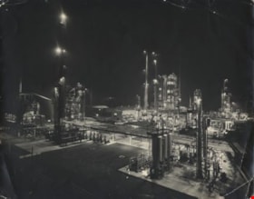
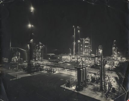
Standard Oil Stanovan Refinery
https://search.heritageburnaby.ca/link/archivedescription34566
- Repository
- City of Burnaby Archives
- Date
- 1958
- Collection/Fonds
- Burnaby Historical Society fonds
- Description Level
- Item
- Physical Description
- 1 photograph : b&w ; 27.8 x 35.3 cm
- Scope and Content
- Photograph of the Standard Oil Company Stanovan Refinery process area, Burrard Inlet. The area is lit up at night. Photograph of the Standard Oil Refinery at night. After the government broke up Standard Oil in 1911, its West Coast operations became the Standard Oil of California (SoCal), owning t…
- Repository
- City of Burnaby Archives
- Date
- 1958
- Collection/Fonds
- Burnaby Historical Society fonds
- Subseries
- Photographs subseries
- Physical Description
- 1 photograph : b&w ; 27.8 x 35.3 cm
- Description Level
- Item
- Record No.
- 052-002
- Access Restriction
- No restrictions
- Reproduction Restriction
- Reproduce for fair dealing purposes only
- Accession Number
- BHS2007-04
- Scope and Content
- Photograph of the Standard Oil Company Stanovan Refinery process area, Burrard Inlet. The area is lit up at night. Photograph of the Standard Oil Refinery at night. After the government broke up Standard Oil in 1911, its West Coast operations became the Standard Oil of California (SoCal), owning the Standard Oil Company of British Columbia Ltd, and adopting the name Chevron in the 1970's.
- Subjects
- Buildings - Industrial - Refineries
- Media Type
- Photograph
- Photographer
- Industrial Photographers
- Notes
- Title based on contents of photograph
- Geographic Access
- Eton Street
- Street Address
- 4403 Eton Street
- Historic Neighbourhood
- Vancouver Heights (Historic Neighbourhood)
- Planning Study Area
- Burnaby Heights Area
Images
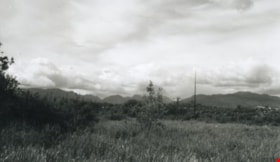
Still Creek
https://search.heritageburnaby.ca/link/archivedescription36510
- Repository
- City of Burnaby Archives
- Date
- 1950
- Collection/Fonds
- Burnaby Historical Society fonds
- Description Level
- Item
- Physical Description
- 1 photograph : b&w ; 8.5 x 14 cm
- Scope and Content
- Photograph of the Burnaby Lake bog taken from a small board walk that connected Sperling Avenue with a trail to Government Road at the west end of Burnaby Lake. Near the modern-day site of the Burnaby Lake Sports fields, this photograph was taken looking north west across Sperling Avenue and Still …
- Repository
- City of Burnaby Archives
- Date
- 1950
- Collection/Fonds
- Burnaby Historical Society fonds
- Subseries
- Photographs subseries
- Physical Description
- 1 photograph : b&w ; 8.5 x 14 cm
- Description Level
- Item
- Record No.
- 288-001
- Access Restriction
- No restrictions
- Reproduction Restriction
- Reproduce for fair dealing purposes only
- Accession Number
- BHS1992-23
- Scope and Content
- Photograph of the Burnaby Lake bog taken from a small board walk that connected Sperling Avenue with a trail to Government Road at the west end of Burnaby Lake. Near the modern-day site of the Burnaby Lake Sports fields, this photograph was taken looking north west across Sperling Avenue and Still Creek.
- Subjects
- Geographic Features - Bogs
- Names
- Still Creek
- Media Type
- Photograph
- Notes
- Title based on contents of photograph
- Photograph is a modern contact print of an original negative that was loaned to the Archives
- Geographic Access
- Still Creek
- Burnaby Lake
- Sperling Avenue
- Historic Neighbourhood
- Burnaby Lake (Historic Neighbourhood)
- Planning Study Area
- Douglas-Gilpin Area
Images
