Narrow Results By
Subject
- Buildings - Public - Post Offices 1
- Buildings - Residential - Houses 1
- First Nations reserves - British Columbia 1
- Geographic Features - Rivers 1
- Geographic Features - Roads 1
- Geographic Features - Streams 1
- Government - Federal Government 1
- Government - Provincial Government 2
- Indigenous peoples - Indian Territory 1
- Land Clearing 1
- Occupations - Civic Workers 1
- Officials 1

Lozells Neighbourhood
https://search.heritageburnaby.ca/link/landmark756
- Repository
- Burnaby Heritage Planning
- Associated Dates
- 1905-1924
- Heritage Value
- In 1906 C.T. Piper and Alfred Wiggs built a sawmill at the foot of what is now Piper Avenue along the north shore of Burnaby Lake. These operations and the proximity of the Great Northern Railway encourage settlers to move into this area and among them were Colonel and Mrs. James Ward. They were authorized to open a post office here and Mrs. Ward named it 'Lozells' after the Anglican parish to which she had been a member in Birmingham, England.
- Historic Neighbourhood
- Lozells (Historic Neighbourhood)
- Planning Study Area
- Government Road Area
Images


Family and political photograph album
https://search.heritageburnaby.ca/link/museumdescription3654
- Repository
- Burnaby Village Museum
- Date
- 1914-1977
- Collection/Fonds
- Harold Edward Winch collection
- Description Level
- Item
- Physical Description
- 1 album (ca. 85 photographs)
- Scope and Content
- Item is a photograph album containing ca. 85 photographs, including both personal and work-related subjects such as the Winch family and homes, and Winch's political work and travels. Also included are some textual records relating to Winch's political work.
- Repository
- Burnaby Village Museum
- Collection/Fonds
- Harold Edward Winch collection
- Description Level
- Item
- Physical Description
- 1 album (ca. 85 photographs)
- Scope and Content
- Item is a photograph album containing ca. 85 photographs, including both personal and work-related subjects such as the Winch family and homes, and Winch's political work and travels. Also included are some textual records relating to Winch's political work.
- Names
- Winch, Harold Edward
- Winch, Linda Marian Hendy
- Winch, Grace
- Winch, Eileen
- Winch, Ernest "Ernie"
- Winch, Eric
- Co-operative Commonwealth Federation "CCF"
- New Democratic Party
- Douglas, Tommy
- MacInnis, Grace
- Accession Code
- BV013.12.11
- Date
- 1914-1977
- Media Type
- Photograph
- Textual Record
- Notes
- Title based on contents of photograph
- A selection of photographs from scrapbook have been described at item level (BV013.12.36 to BV015.35.117)
Images

Documents

Government Docks, New Westminster
https://search.heritageburnaby.ca/link/archivedescription39576
- Repository
- City of Burnaby Archives
- Date
- 1910
- Collection/Fonds
- Peers Family and Hill Family fonds
- Description Level
- Item
- Physical Description
- 1 photograph : b&w ; 7.8 x 10.2 cm on page 21.5 x 28 cm (pasted in album)
- Scope and Content
- Photograph of a boat (the "Vite") pulled up to the Government docks at the foot of 8th Street in New Westminster. Queensborough can be seen in the background. The three men in the boat are unidentified.
- Repository
- City of Burnaby Archives
- Date
- 1910
- Collection/Fonds
- Peers Family and Hill Family fonds
- Physical Description
- 1 photograph : b&w ; 7.8 x 10.2 cm on page 21.5 x 28 cm (pasted in album)
- Description Level
- Item
- Record No.
- 477-895
- Access Restriction
- No restrictions
- Reproduction Restriction
- No known restrictions
- Accession Number
- 2007-12
- Scope and Content
- Photograph of a boat (the "Vite") pulled up to the Government docks at the foot of 8th Street in New Westminster. Queensborough can be seen in the background. The three men in the boat are unidentified.
- Subjects
- Recreational Activities - Boating
- Structures - Piers and Wharves
- Geographic Features - Rivers
- Media Type
- Photograph
- Notes
- Title based on contents of photograph
Images


Government Road
https://search.heritageburnaby.ca/link/archivedescription35567
- Repository
- City of Burnaby Archives
- Date
- 1912 (date of original), copied 1986
- Collection/Fonds
- Burnaby Historical Society fonds
- Description Level
- Item
- Physical Description
- 1 photograph : b&w ; 12.7 x 17.8 cm print
- Scope and Content
- Photograph looking east on Government Road from the Haddon family house. One of the men in the photo is Robert Haddon. The other two people are unidentified. Note the loose gravel roadway and the bridge over Eagle Creek.
- Repository
- City of Burnaby Archives
- Date
- 1912 (date of original), copied 1986
- Collection/Fonds
- Burnaby Historical Society fonds
- Subseries
- Pioneer Tales subseries
- Physical Description
- 1 photograph : b&w ; 12.7 x 17.8 cm print
- Description Level
- Item
- Record No.
- 204-425
- Access Restriction
- No restrictions
- Reproduction Restriction
- No known restrictions
- Accession Number
- BHS1988-03
- Scope and Content
- Photograph looking east on Government Road from the Haddon family house. One of the men in the photo is Robert Haddon. The other two people are unidentified. Note the loose gravel roadway and the bridge over Eagle Creek.
- Names
- Haddon, Robert
- Media Type
- Photograph
- Notes
- Title based on contents of photograph
- Geographic Access
- Eagle Creek
- Government Road
- Historic Neighbourhood
- Lozells (Historic Neighbourhood)
- Planning Study Area
- Government Road Area
Images

![Government Road property, [191-] (date of original), copied 1986 thumbnail](/media/hpo/_Data/_Archives_Images/_Unrestricted/204/204-689.jpg?width=280)
Government Road property
https://search.heritageburnaby.ca/link/archivedescription35830
- Repository
- City of Burnaby Archives
- Date
- [191-] (date of original), copied 1986
- Collection/Fonds
- Burnaby Historical Society fonds
- Description Level
- Item
- Physical Description
- 1 photograph : b&w ; 12.7 x 17.8 cm print
- Scope and Content
- Photograph of (left) James Ker (maternal grandfather), (right) Robert Haddon (father), and Gordon Haddon (son), cutting firewood from a large fallen fir with a Wee MacGregor chainsaw on their Hastings Mill property south of the family home on Government Road.
- Repository
- City of Burnaby Archives
- Date
- [191-] (date of original), copied 1986
- Collection/Fonds
- Burnaby Historical Society fonds
- Subseries
- Pioneer Tales subseries
- Physical Description
- 1 photograph : b&w ; 12.7 x 17.8 cm print
- Description Level
- Item
- Record No.
- 204-689
- Access Restriction
- No restrictions
- Reproduction Restriction
- No restrictions
- Accession Number
- BHS1988-03
- Scope and Content
- Photograph of (left) James Ker (maternal grandfather), (right) Robert Haddon (father), and Gordon Haddon (son), cutting firewood from a large fallen fir with a Wee MacGregor chainsaw on their Hastings Mill property south of the family home on Government Road.
- Subjects
- Land Clearing
- Plants - Trees
- Media Type
- Photograph
- Notes
- Title based on contents of photograph
- Geographic Access
- Government Road
- Historic Neighbourhood
- Lozells (Historic Neighbourhood)
- Planning Study Area
- Government Road Area
Images
![Government Road property, [191-] (date of original), copied 1986 thumbnail](/media/hpo/_Data/_Archives_Images/_Unrestricted/204/204-689.jpg)

Broadview Neighbourhood
https://search.heritageburnaby.ca/link/landmark750
- Repository
- Burnaby Heritage Planning
- Associated Dates
- 1905-1924
- Heritage Value
- Between 1905 and 1924, the Broadview neighbourhood in Burnaby was settled by almost 100 families who saw the advantage of living in an area that was served by two railway lines - the B.C. Electric Railway and the Great Northern Railway. Touted as being only a 20 minute car ride to the city centre, this neighbourhood expanded during the early 1920s with the promise of a new direct access road to the city being built by the Great Northern Railway company and new blocks being opened up on two government reserves adjoining it.
- Historic Neighbourhood
- Broadview (Historic Neighbourhood)
- Planning Study Area
- Cascade-Schou Area
Images


Oakalla Prison
https://search.heritageburnaby.ca/link/landmark752
- Repository
- Burnaby Heritage Planning
- Geographic Access
- Royal Oak Avenue
- Associated Dates
- 1912
- Heritage Value
- The Oakalla Prison Farm opened in 1912 and was hailed as the most modern facility of its kind. Initially designed to hold 150 men and 50 women, by the 1950s, the population was well over 1000. A working farm, the prison had its own dairy, vegetable gardens and livestock. From the beginning, the location of Oakalla on 185 acres of scenic land next to Burnaby's Deer Lake was the source of contention with residents petitioning the government to relocate the prison and by 1979 it was decided to close the farm and 64 acres of land were transferred to Burnaby for inclusion on the Deer Lake Park. In 1991, Oakalla closed forever and the buildings were demolished to make way for a new residential housing development and an expansion of the park.
- Historic Neighbourhood
- Burnaby Lake (Historic Neighbourhood)
- Planning Study Area
- Oakalla Area
Images


Ocean View Burial Park - Landscape
https://search.heritageburnaby.ca/link/landmark629
- Repository
- Burnaby Heritage Planning
- Description
- Cemetery site.
- Associated Dates
- 1919
- Street View URL
- Google Maps Street View
- Repository
- Burnaby Heritage Planning
- Geographic Access
- Imperial Street
- Associated Dates
- 1919
- Description
- Cemetery site.
- Heritage Value
- Burnaby’s landmark Ocean View Burial Park was British Columbia’s first non-sectarian cemetery created as a for-profit business enterprise. Organized by a group of local investors headed by Lieut. Col. G.H. Dorrell, the Ocean View Cemetery Company offered a place for burials that was not owned or associated with a civic government, religious or fraternal organization. The cemetery’s design was the vision of Albert F. Arnold, an officer of the Canadian Financiers Trust Company, who was “...always depressed by the lack of beauty in so many places of internment and inevitable neglect that finally reduced them to long-grassed places of unhappy memories.” One local newspaper described the landscape of the cemetery: "The design includes ornamental trees and shrubs, beautiful flower beds and smooth winding walks and drives, with a total absence of the usual somewhat ostentatious reminders of the harvest garnered by the grim reaper."
- Locality
- Alta Vista
- Historic Neighbourhood
- Alta Vista (Historic Neighbourhood)
- Planning Study Area
- Suncrest Area
- Architect
- Albert F. Arnold
- Area
- 359280.00
- Contributing Resource
- Landscape Feature
- Ownership
- Private
- Street Address
- 4000 Imperial Street
- Street View URL
- Google Maps Street View
Images


R.F. Anderson House
https://search.heritageburnaby.ca/link/landmark531
- Repository
- Burnaby Heritage Planning
- Description
- The R.F. Anderson House is a large, two-and-one-half storey Arts and Crafts style wood frame house, now located in Deer Lake Park, built as a family home and now used as institutional offices.
- Associated Dates
- 1912
- Formal Recognition
- Heritage Designation, Community Heritage Register
- Other Names
- Robert Fenwick & Bessie Anderson House, Anderson Residence
- Street View URL
- Google Maps Street View
- Repository
- Burnaby Heritage Planning
- Other Names
- Robert Fenwick & Bessie Anderson House, Anderson Residence
- Geographic Access
- Deer Lake Avenue
- Associated Dates
- 1912
- Formal Recognition
- Heritage Designation, Community Heritage Register
- Enactment Type
- Bylaw No. 9807
- Enactment Date
- 23/11/1992
- Description
- The R.F. Anderson House is a large, two-and-one-half storey Arts and Crafts style wood frame house, now located in Deer Lake Park, built as a family home and now used as institutional offices.
- Heritage Value
- The R.F. Anderson House contributes to the overall stylistic ambiance of the area and demonstrates that a range of architectural features can be read as a cohesive whole. Although designed primarily in the British Arts and Crafts genre, as were other residences around Deer Lake, it also displays some influences of the popular Craftsman style. It was constructed in the Deer Lake Crescent subdivision, which was originally promoted as an upper class neighbourhood. It represents one of the first residential developments in the City of Burnaby that required buildings to be of a specific value, thus demonstrating the desire for exclusivity among the successful businessmen who chose to settle in the area. The house and grounds illustrate the social, cultural, lifestyle and leisure sensibilities of a successful local businessman and his family in the early twentieth century; Anderson was a New Westminster hardware merchant and Justice of the Peace. The development of the house and grounds within a controlled suburban context also illustrate the values of the owners in the Deer Lake Crescent subdivision, such as social aspiration, racial exclusivity, demonstration of architectural taste, importance of a landscaped garden, and the provision of facilities for fashionable leisure pursuits such as lawn tennis. The estate makes an important contribution to the residential grouping now preserved within Deer Lake Park, and demonstrates the broad social mix of those who chose to live in the area at a time when it was in transition from a market gardening area to a more exclusive residential community. The R.F. Anderson House is important for its association with local architect Frank William Macey (1863-1935), the first resident architect in Burnaby. Macey was born and trained in England where he was well-respected for having published two standard texts for the architectural profession. He settled in Burnaby in the first decade of the twentieth century and obtained a number of commissions from prominent businessmen who were building grand homes in the new community of Deer Lake. He designed these houses mostly in the British Arts and Crafts style.
- Defining Elements
- Key elements that define the heritage character of the R.F. Anderson House include its: - location within a park setting in relation to the W.J. Mathers House - irregular massing of the exterior and its cladding of drop-siding, with half-timbering and rough-cast stucco in the gables - picturesque irregular roofline, including an alteration in pitch over the front verandah, with cedar shingle cladding - interior plan with its generous entrance hall, staircase, and massive staircase window with leaded-lights - multiple-assembly wooden-sash casement windows - quality of interior features such as the Douglas Fir woodwork (some with original varnish finish); original hardware supplied by Anderson's hardware company; and original fireplaces with ornate tile surrounds - setting with the imprint of the lawn tennis court, now a garden terrace, and some of the original plantings
- Locality
- Deer Lake Park
- Historic Neighbourhood
- Burnaby Lake (Historic Neighbourhood)
- Planning Study Area
- Douglas-Gilpin Area
- Architect
- Frank William Macey
- Function
- Primary Current--Government Office
- Primary Historic--Single Dwelling
- Community
- Burnaby
- Cadastral Identifier
- P.I.D. No. 007-525-931 Legal Description: North 225 feet Lot 'C', District Lot 79, Group 1, New Westminster District, Plan 6884
- Boundaries
- The R.F. Anderson House is comprised of a single municipally-owned property located at 6450 Deer Lake Avenue, Burnaby.
- Area
- 63,100.00
- Contributing Resource
- Building
- Landscape Feature
- Ownership
- Public (local)
- Documentation
- Heritage Site Files: PC77000 20. City of Burnaby Planning and Building Department, 4949 Canada Way, Burnaby, B.C., V5G 1M2
- Names
- Macey, Frank W.
- Street Address
- 6450 Deer Lake Avenue
- Street View URL
- Google Maps Street View
Images


Russian Submarines at Barnet
https://search.heritageburnaby.ca/link/landmark748
- Repository
- Burnaby Heritage Planning
- Associated Dates
- 1915-1917
- Heritage Value
- This site was a top secret site where 460 men worked on the assembly of five submarines for the Russian Navy during World War I. The Seattle contractor was forbidden from doing the work in the US because of American neutrality regulations and he set up the secret plant here without the knowledge of the Canadian Government.
- Historic Neighbourhood
- Barnet (Historic Neighbourhood)
- Planning Study Area
- Burnaby Mountain Area
Images

![B.C. Parliament Building in Victoria, [ca. 1920] thumbnail](/media/hpo/_Data/_BVM_Images/1985/1985_5899_0003_001.jpg?width=280)
B.C. Parliament Building in Victoria
https://search.heritageburnaby.ca/link/museumdescription1527
- Repository
- Burnaby Village Museum
- Date
- [ca. 1920]
- Collection/Fonds
- Burnaby Village Museum Photograph collection
- Description Level
- Item
- Physical Description
- 1 photograph : b&w ; 6.5 x 9 cm
- Scope and Content
- Photograph of the British Columbia Parliament Buildings, home of the Legislative Assembly of British Columbia located in Victoria. There are people standing on the steps to the front entrance. There is a sign on the lawn in front of the parliament buliding that reads, "PLEASE KEEP OFF THE GRASS."
- Repository
- Burnaby Village Museum
- Collection/Fonds
- Burnaby Village Museum Photograph collection
- Description Level
- Item
- Physical Description
- 1 photograph : b&w ; 6.5 x 9 cm
- Material Details
- stamped on verso, t. "159"
- Scope and Content
- Photograph of the British Columbia Parliament Buildings, home of the Legislative Assembly of British Columbia located in Victoria. There are people standing on the steps to the front entrance. There is a sign on the lawn in front of the parliament buliding that reads, "PLEASE KEEP OFF THE GRASS."
- Subjects
- Government - Provincial Government
- Geographic Access
- Victoria
- Accession Code
- BV985.5899.3
- Access Restriction
- No restrictions
- Reproduction Restriction
- No known restrictions
- Date
- [ca. 1920]
- Media Type
- Photograph
- Scan Resolution
- 600
- Scan Date
- 2024-02-27
- Notes
- Title based on contents of photograph
Images
![B.C. Parliament Building in Victoria, [ca. 1920] thumbnail](/media/hpo/_Data/_BVM_Images/1985/1985_5899_0003_001.jpg)

Haddon family home
https://search.heritageburnaby.ca/link/archivedescription35564
- Repository
- City of Burnaby Archives
- Date
- 1919 (date of original), copied 1986
- Collection/Fonds
- Burnaby Historical Society fonds
- Description Level
- Item
- Physical Description
- 1 photograph : b&w ; 12.7 x 17.8 cm print
- Scope and Content
- Photograph of the Haddon family home at 7870 Government Road between Lozells Avenue and Piper Avenue. Three adults and a young child are standing in at the front door.
- Repository
- City of Burnaby Archives
- Date
- 1919 (date of original), copied 1986
- Collection/Fonds
- Burnaby Historical Society fonds
- Subseries
- Pioneer Tales subseries
- Physical Description
- 1 photograph : b&w ; 12.7 x 17.8 cm print
- Description Level
- Item
- Record No.
- 204-422
- Access Restriction
- No restrictions
- Reproduction Restriction
- No known restrictions
- Accession Number
- BHS1988-03
- Scope and Content
- Photograph of the Haddon family home at 7870 Government Road between Lozells Avenue and Piper Avenue. Three adults and a young child are standing in at the front door.
- Subjects
- Buildings - Residential - Houses
- Media Type
- Photograph
- Notes
- Title based on contents of photograph
- Geographic Access
- Government Road
- Street Address
- 7870 Government Road
- Historic Neighbourhood
- Lozells (Historic Neighbourhood)
- Planning Study Area
- Government Road Area
Images

![J.E. and Hephezebah Ward, [1912] (date of original) thumbnail](/media/hpo/_Data/_Archives_Images/_Unrestricted/251/312-001.jpg?width=280)
J.E. and Hephezebah Ward
https://search.heritageburnaby.ca/link/archivedescription36626
- Repository
- City of Burnaby Archives
- Date
- [1912] (date of original)
- Collection/Fonds
- Burnaby Historical Society fonds
- Description Level
- Item
- Physical Description
- 1 photograph : b&w ; 12.5 x 8.5 cm print
- Scope and Content
- Photograph of Lieutenant Colonel James E. Ward standing next to his wife Hephzebah, who is sitting in a wicker chair outside on the front porch. They look to be on the porch of the Lozells Post Office at the north eastern corner of the Great Northern tracks and Piper Road. In 1908 the couple came t…
- Repository
- City of Burnaby Archives
- Date
- [1912] (date of original)
- Collection/Fonds
- Burnaby Historical Society fonds
- Subseries
- Richard Hardy family subseries
- Physical Description
- 1 photograph : b&w ; 12.5 x 8.5 cm print
- Description Level
- Item
- Record No.
- 312-001
- Access Restriction
- No restrictions
- Reproduction Restriction
- No known restrictions
- Accession Number
- BHS1993-09
- Scope and Content
- Photograph of Lieutenant Colonel James E. Ward standing next to his wife Hephzebah, who is sitting in a wicker chair outside on the front porch. They look to be on the porch of the Lozells Post Office at the north eastern corner of the Great Northern tracks and Piper Road. In 1908 the couple came to Burnaby and opened the post office (naming it Lozells because when they lived in Birmingham England, Hepezebah was a parishioner in the Anglican Parish of Lozells).
- Media Type
- Photograph
- Notes
- Title based on contents of photograph
- Historic Neighbourhood
- Lozells (Historic Neighbourhood)
- Planning Study Area
- Government Road Area
Images
![J.E. and Hephezebah Ward, [1912] (date of original) thumbnail](/media/hpo/_Data/_Archives_Images/_Unrestricted/251/312-001.jpg)
![Lozells Post Office in Burnaby, [between 1910 and 1913] thumbnail](/media/hpo/_Data/_BVM_Images/1975/1975_0032_0002_001.jpg?width=280)
Lozells Post Office in Burnaby
https://search.heritageburnaby.ca/link/museumdescription898
- Repository
- Burnaby Village Museum
- Date
- [between 1910 and 1913]
- Collection/Fonds
- Burnaby Village Museum Photograph collection
- Description Level
- Item
- Physical Description
- 1 photograph : b&w ; 8.2 x 13.7 cm
- Scope and Content
- Photograph of Lozells Post Office, on the north shore of Burnaby Lake. This two storey house stood at the north eastern corner of the Great Northern tracks and Piper Road. Around the house is a low picket fence, and a large sign that read, "LOZELLS." In 1908, Col. James Ward and his wife, Mrs. War…
- Repository
- Burnaby Village Museum
- Collection/Fonds
- Burnaby Village Museum Photograph collection
- Description Level
- Item
- Physical Description
- 1 photograph : b&w ; 8.2 x 13.7 cm
- Scope and Content
- Photograph of Lozells Post Office, on the north shore of Burnaby Lake. This two storey house stood at the north eastern corner of the Great Northern tracks and Piper Road. Around the house is a low picket fence, and a large sign that read, "LOZELLS." In 1908, Col. James Ward and his wife, Mrs. Ward, came to Lozells and opened a post office. Mrs. Ward named the place Lozells because when she lived in Birmingham England, she was a parishioner in the Anglican Parish of Lozells. (Reference: George Green's "History of Burnaby" p147).
- History
- Mrs. Lozells had lived in Birmingham, England, was a parishoner in the Anglican parish of Lozells in the city. The Graeat Northern Railway laid its tracks through this district [ ] and hwne this rail route was completed the Royal City Mills built a sawmill of considerable size near the foot of Piper Avenue. C.T.W. Pyper and Alfred Wiggs built a small mill nearby and a shipping siding was installed and called Pyper's Siding. (Reference from HIstory of Burnaby by George Green.)
- Subjects
- Buildings - Public - Post Offices
- Accession Code
- HV975.32.2
- Access Restriction
- No restrictions
- Reproduction Restriction
- No known restrictions
- Date
- [between 1910 and 1913]
- Media Type
- Photograph
- Historic Neighbourhood
- Lozells (Historic Neighbourhood)
- Planning Study Area
- Government Road Area
- Scan Resolution
- 600
- Scan Date
- 2023-06-06
- Notes
- Title based on contents of photograph
Images
![Lozells Post Office in Burnaby, [between 1910 and 1913] thumbnail](/media/hpo/_Data/_BVM_Images/1975/1975_0032_0002_001.jpg)
![Richard and Edith Hardy, [1912] (date of original) thumbnail](/media/hpo/_Data/_Archives_Images/_Unrestricted/251/312-003.jpg?width=280)
Richard and Edith Hardy
https://search.heritageburnaby.ca/link/archivedescription36628
- Repository
- City of Burnaby Archives
- Date
- [1912] (date of original)
- Collection/Fonds
- Burnaby Historical Society fonds
- Description Level
- Item
- Physical Description
- 1 photograph : b&w ; 12.5 x 8.5 cm print
- Scope and Content
- Photograph of Richard and Edith Hardy standing inside a fenced yard. Edith has her arms around Richard's shoulders. They are most likely at the Lozells Post Office at the north eastern corner of the Great Northern tracks and Piper Road. In 1908, Col. James Ward and his wife Hepezebah came to Burna…
- Repository
- City of Burnaby Archives
- Date
- [1912] (date of original)
- Collection/Fonds
- Burnaby Historical Society fonds
- Subseries
- Richard Hardy family subseries
- Physical Description
- 1 photograph : b&w ; 12.5 x 8.5 cm print
- Description Level
- Item
- Record No.
- 312-003
- Access Restriction
- No restrictions
- Reproduction Restriction
- No known restrictions
- Accession Number
- BHS1993-09
- Scope and Content
- Photograph of Richard and Edith Hardy standing inside a fenced yard. Edith has her arms around Richard's shoulders. They are most likely at the Lozells Post Office at the north eastern corner of the Great Northern tracks and Piper Road. In 1908, Col. James Ward and his wife Hepezebah came to Burnaby and opened the post office (naming it Lozells because when they lived in Birmingham England, Hepezebah was a parishioner in the Anglican Parish of Lozells).
- Names
- Hardy, Richard
- Hardy, Edith
- Media Type
- Photograph
- Notes
- Title based on contents of photograph
- Historic Neighbourhood
- Lozells (Historic Neighbourhood)
- Planning Study Area
- Government Road Area
Images
![Richard and Edith Hardy, [1912] (date of original) thumbnail](/media/hpo/_Data/_Archives_Images/_Unrestricted/251/312-003.jpg)
![Ward family, [1912] (date of original) thumbnail](/media/hpo/_Data/_Archives_Images/_Unrestricted/251/312-004.jpg?width=280)
Ward family
https://search.heritageburnaby.ca/link/archivedescription36629
- Repository
- City of Burnaby Archives
- Date
- [1912] (date of original)
- Collection/Fonds
- Burnaby Historical Society fonds
- Description Level
- Item
- Physical Description
- 1 photograph : b&w ; 8 x 12.5 cm print
- Scope and Content
- Photograph of the Ward Family, including children and grandchildren sitting outside. They are most likely on the porch of the Lozells Post Office at the north eastern corner of the Great Northern tracks and Piper Road. In 1908, Col. James Ward and his wife Hepezebah came to Burnaby and opened the p…
- Repository
- City of Burnaby Archives
- Date
- [1912] (date of original)
- Collection/Fonds
- Burnaby Historical Society fonds
- Subseries
- Richard Hardy family subseries
- Physical Description
- 1 photograph : b&w ; 8 x 12.5 cm print
- Description Level
- Item
- Record No.
- 312-004
- Access Restriction
- No restrictions
- Reproduction Restriction
- No known restrictions
- Accession Number
- BHS1993-09
- Scope and Content
- Photograph of the Ward Family, including children and grandchildren sitting outside. They are most likely on the porch of the Lozells Post Office at the north eastern corner of the Great Northern tracks and Piper Road. In 1908, Col. James Ward and his wife Hepezebah came to Burnaby and opened the post office (naming it Lozells because when they lived in Birmingham England, Hepezebah was a parishioner in the Anglican Parish of Lozells).
- Media Type
- Photograph
- Notes
- Title based on contents of photograph
- Historic Neighbourhood
- Lozells (Historic Neighbourhood)
- Planning Study Area
- Government Road Area
Images
![Ward family, [1912] (date of original) thumbnail](/media/hpo/_Data/_Archives_Images/_Unrestricted/251/312-004.jpg)

The listening post, no. 29
https://search.heritageburnaby.ca/link/museumlibrary6786
- Repository
- Burnaby Village Museum
- Collection
- Special Collection
- Material Type
- Textual Record
- Accession Code
- BV016.48.7
- Call Number
- 355 LIS
- Publication Date
- 1917
- Physical Description
- 47 p. : ill. ; 33 cm.
- Inscription
- 3
- Library Subject (LOC)
- Canada--Politics and government
- Military art and science--Canada
- Canada--History, Military
- World War, 1914-1918
- Periodicals
- Object History
- Military documents and memorabilia of First World War activities of Russell William Mawhinney. Later career of Mr Mawhinney as a Pharmacist in the Dunbar neighbourhood of Vancouver. Papers and memorabilia relating to Mr Mawhinney as an organizer of the Ex RAF Officers Association.
- Notes
- "Special Xmas Number"
Images

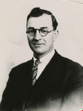
![Charles Boyer Brown, by photographer Nicholas Rossmo [1950]. Item no. 307-008 thumbnail](/media/hpo/_Data/_Archives_Images/_Unrestricted/251/307-008.jpg?width=280)
Interview with Charles B. Brown May 21, 1975 - Track 1
https://search.heritageburnaby.ca/link/oralhistory27
- Repository
- City of Burnaby Archives
- Date Range
- 1909-1938
- Length
- 00:07:15
- Summary
- This portion of the interview pertains to Charles Boyer Brown's early days working at Burnaby's Municipal Hall, first as an office boy.
- Repository
- City of Burnaby Archives
- Summary
- This portion of the interview pertains to Charles Boyer Brown's early days working at Burnaby's Municipal Hall, first as an office boy.
- Date Range
- 1909-1938
- Photo Info
- Charles Boyer Brown, by photographer Nicholas Rossmo [1950]. Item no. 307-008
- Length
- 00:07:15
- Subjects
- Occupations - Civic Workers
- Interviewer
- Bradbury, Dr. Bettina
- Interview Date
- May 21, 1975
- Scope and Content
- Recording is a taped interview with Charles B. Brown by SFU (Simon Fraser University) graduate student Bettina Bradbury May 21, 1975. Major themes discussed are: the Depression, the Commissioner and municipal politics in general. To view "Narrow By" terms for each track expand this description and see "Notes".
- Biographical Notes
- Charles Boyer Brown was born on June 16, 1894 in the town of Ongar, Essex, England. He came to Canada as a young child with his parents Jean and Percy Brown. In 1903, the family settled in New Westminster and by 1911, Charles had joined the Burnaby municipal staff working as an office boy. The outbreak of World War One interrupted Charlie’s career as he immediately enlisted with the Royal Engineers and served from 1915 to 1918. While overseas he met and married Lillian Bernice Bryan and they returned to Canada together after the war and Charles resumed his position in municipal administration. For a short time, Charles was appointed as the Municipal Assessor, but in 1927 he became the Assistant Municipal Clerk. In 1933, Charles was made Municipal Clerk, a post he held until he retired in 1959. Charles has also been credited with playing a significant role in administering the city while it was under the rule of the provincial commission from 1932-1942. Recognized for his expertise in civic affairs, Charles was appointed by the provincial government to a committee formed to review and revise the Municipal Act. He was also a member of the BC Municipal Officers’ Association from its formation in 1936 and was made its chair in 1953. While these civic duties occupied much of his time, Charles still managed to participate as a volunteer on many sport and youth clubs in the city and served as the secretary for the Kingsway Rotary Club. In recognition of his outstanding contributions to Burnaby, both paid and volunteer, Charles was presented with the Gold Key award in 1959, the same year he finally retired from municipal administration. During Charles’ lifetime, many changes took place in the Municipality that he loved. He saw Burnaby grow in population and progress and he could be proud of the significant part he played in that growth and development. Charles Brown died on August 11, 1981.
- Total Tracks
- 8
- Total Length
- 0:58:01
- Interviewee Name
- Brown, Charles B. "Charlie"
- Interview Location
- Walker Avenue
- Interviewer Bio
- Bettina Bradbury teaches history and women's studies at York University. She is the author of Wife to Widow. Lives, Laws and Politics in Nineteenth-century Montreal. (Vancouver: University of British Columbia Press, June 2011), 520p; Working Families. Age, Gender and Daily Survival in Industrializing Montreal. (Toronto: Canadian Social History Series, McClelland and Stewart, 1993); (Republished Toronto: Oxford University Press, 1996) (3rd edition, Toronto: University of Toronto Press, 2007). These interviews were undertaken after she completed her MA at Simon Fraser University in 1975 with the support of an LIP grant.
- Collection/Fonds
- Burnaby Historical Society fonds
- Subseries
- Oral history subseries
- Transcript Available
- None
- Media Type
- Sound Recording
- Web Notes
- Interview was digitized in 2010 allowing it to be accessible on Heritage Burnaby. The digitization project was initiated by the Community Heritage Commission with support from City of Burnaby Council and the BC History Digitization Program of the Irving K. Barber Learning Centre, University of British Columbia. It was recognized by the Heritage Society of BC with an award in 2012.
Images
![Charles Boyer Brown, by photographer Nicholas Rossmo [1950]. Item no. 307-008 thumbnail](/media/hpo/_Data/_Archives_Images/_Unrestricted/251/307-008.jpg)
Audio Tracks
Track one of interview with Charles B. Brown
Track one of interview with Charles B. Brown
https://search.heritageburnaby.ca/media/hpo/_Data/_Archives_Oral_Histories/_Unrestricted/100-13-06/100-13-06_Track_1.mp3![Survey and Subdivision plans in New Westminster District Group 1 and Group 2 – Vancouver, ʷməθkʷəy̓əm (Musqueam) Indian Reserve, Burnaby, Surrey
, [1910-1911] thumbnail](/media/hpo/_Data/_BVM_Cartographic_Material/1977/1977_0093_0017_001.jpg?width=280)
Survey and Subdivision plans in New Westminster District Group 1 and Group 2 – Vancouver, ʷməθkʷəy̓əm (Musqueam) Indian Reserve, Burnaby, Surrey
https://search.heritageburnaby.ca/link/museumdescription6986
- Repository
- Burnaby Village Museum
- Date
- [1910-1911]
- Collection/Fonds
- Burnaby Village Museum Map collection
- Description Level
- File
- Physical Description
- 9 plans : 4 plans : blueprint ink on paper + 4 plans : black ink on paper + 1 plan : graphite on paper mounted on 2 sides of cardboard 76 x 102 cm
- Scope and Content
- File consists of a large board of three survey plans in New Westminster District Group 1 mounted on one side and six survey and subdivision plans of District Lot 85, New Westminster District Group 1 mounted on the other side. Side A: 1. Plan : blueprint on paper ; 30.5 x 80 cm. Title reads: "Fras…
- Repository
- Burnaby Village Museum
- Collection/Fonds
- Burnaby Village Museum Map collection
- Description Level
- File
- Physical Description
- 9 plans : 4 plans : blueprint ink on paper + 4 plans : black ink on paper + 1 plan : graphite on paper mounted on 2 sides of cardboard 76 x 102 cm
- Material Details
- Scales vary (One chain equals 792 inches)
- Indexed number on tape on edge of board reads "17"
- Scope and Content
- File consists of a large board of three survey plans in New Westminster District Group 1 mounted on one side and six survey and subdivision plans of District Lot 85, New Westminster District Group 1 mounted on the other side. Side A: 1. Plan : blueprint on paper ; 30.5 x 80 cm. Title reads: "Fraser River Bridge / Plan of South Approach". Plan covers area of land north of the Fraser River and Great Northern Railway with approach for a bridge running through the "ʷməθkʷəy̓əm (Musqueam) Indian Reserve" (ʷməθkʷəy̓əm (Musqueam) First Nation) and lots marked as Dominion Government and the east half of Lot 2 identified as "C. F. Brown" "Plan 851". Plan is identified as "Plan 851 / traced / Mar. 17, 1911". (Geographic location in Vancouver) Scale: 100 feet = 1 inch, Signed by Albert J. Hill / P.L.S." 2. Plan : blueprint on paper ; 36.5 x 35 cm (no title). Includes three plans of lots on the east and west sides of North Road. Note on bottom of blueprint reads: "I.E.B. McKay Surveyor General - hereby certify / that this is a correct tracing from the field / notes of the Royal Engineers on file in the / Lands Department / E.B. McKay (signature) / Surveyor General / Victoria B.C. April 11th 1911" . Plan in top left titled "Page 11 / Vol. 1. / R.E. Notes" covers District Lots east of North Road including Lot 5, Lot 7, Lot 41, Lot 9 and Lot 107 in Coquitlam. Plan in top right corner titled "Page 17 / Vol. 1. / R.E. Notes" covers District Lots east of North Road including Lot 104, Lot 54, Lot 105, Lot 55, Lot 106, Lot 9 and Lot 107 in Coquitlam and Port Moody. Plan in lower left corner titled "Page 15 / Vol. 1 / R.E. Notes" covers District Lots west of North Road including Lot 147, Lot 148, Lot 100, Lot 15 in Burnaby. 3. Plan : blue print on paper ; 29.5 x 41.5 cm. (no formal title). Plan of the North 1/2 of Section 18. Plan covers area in the "North 1/2 of Sec.18 B.5 N RGE 1 W" and "Sec. 18 B.5 N. RGE 1 W" bordered by Section 7, Section 13, Section 17 and Section 19. Bon Accord Road runs through Sec. 18. The plan is signed by surveryor "I.H. Neville Smith... C.E.B.C.L.S. / Mar. 26th 1910" and signed by "Ludwig Pillath". (Geographic location: Surrey) Side B: 1. Plan : blueprint on paper ; 43.5 x 49.5 cm. Title reads: "Plan / of Subdivision / of a Portion / of / Lot 85 / Group One / New Westminster District. Plan covers portion of land east of Deer Lake and Pole Line Road (Sperling Avenue) and south of Hastings Road in District Lot 85 in Burnaby with section 4 and a portion of section 2 coloured in red. Plan is signed by "Albert J. Hill, B.C.L.S." Plan is initialed by: "RB" [sic] (in blue pencil crayon) Scale: 4 chains = 1 inch 2. Plaln : black black ink on linen ; 39 x 37 cm. Title reads: "L.C. Hill's Property, / Burnaby". Plan covers a triangular portion of land east of Pole Line Road (Sperling Avenue) and south of Hastings Road in District Lot 85 in Burnaby. Plan is intitaled by "RB" [sic] (in blue pencil crayon). Scale: 3 chains = 1 mile 3. Plan : graphite on paper ; 23 x 17 cm. Title reads: "Portion of Lot 85 / Gr.1". Plan covers portion of land north east of Deer Lake and west of Pole Line Road (now Sperling Avenue) in District Lot 85 in Burnaby. Plan is stamped in red ink: "Albert J. Hill, Civil Engineer". Plan is initialed by: "RB" [sic] (in blue pencil crayon). Scale: 1 chain = 1 inch 4. Plan : black ink on linen ; 16 x 19 cm. Title reads: "Lot 85". Plan covers the intersection of Pole Line Road (Sperling Avenue) and Hastings Road at the north west section of District Lot 79 and District Lot 85 in Burnaby. Plan is stamped: "A.J. Hill, Civil Engineer" with identitifed in blue pencil crayon. 5. Plan : black ink on paper ; 28.5 x 37 cm. (no formal title) Plan covers an area of land, west of Pole Line Road (Sperling Avenue) and south of Deer Lake in District Lot 85 in Burnaby. Plan is initialed by: "RB" [sic] (in blue pencil crayon) 6. Plan : black ink on paper ; 21 x 34 cm (no formal title). Plan covers an area of land, west of Pole Line Road (Sperling Avenue) and south of Deer Lake in District Lot 85 in Burnaby. Plan is initialed by: "RB" [sic] (in blue pencil crayon)
- Accession Code
- HV977.93.17
- Access Restriction
- No restrictions
- Reproduction Restriction
- No known restrictions
- Date
- [1910-1911]
- Media Type
- Cartographic Material
- Historic Neighbourhood
- Burnaby Lake (Historic Neighbourhood)
- Burquitlam (Historic Neighbourhood)
- Planning Study Area
- Morley-Buckingham Area
- Douglas-Gilpin Area
- Scan Resolution
- 600
- Scan Date
- 2023-06-26
- Notes
- Title based on contents of file
- Scale is measured in chains and feet. (One chain equals 792 inches).
- The term "Lot" also refers to a "District Lot”
- Some plans are stamped: "Albert J. Hill, Civil Engineer / and / Provincial Land Surveyor, / New Westminster, / B.C." and intialed: "RB" [sic]
Zoomable Images
![Survey and Subdivision plans in New Westminster District Group 1 and Group 2 – Vancouver, ʷməθkʷəy̓əm (Musqueam) Indian Reserve, Burnaby, Surrey
, [1910-1911] thumbnail](/media/hpo/_Data/_BVM_Cartographic_Material/1977/1977_0093_0017_003_seadragon/1977_0093_0017_003.jpg?w=280)
Survey and Subdivision plans in New Westminster District Group 1 and Group 2 – Vancouver, ʷməθkʷəy̓əm (Musqueam) Indian Reserve, Burnaby, Surrey , [1910-1911]
Zoom into Image
Interview with William Pritchard and Norman Penner by Dr. Lawrence Fast July / August 1973 - Track 1
https://search.heritageburnaby.ca/link/oralhistory74
- Repository
- City of Burnaby Archives
- Date Range
- predominate 1919, 1973
- Length
- 0:09:54
- Summary
- This portion of the interview pertains to how the book "Winnipeg 1919", edited by Norman Penner, came into being. Both Norman Penner and labour activist William A. Pritchard answer questions posed by Dr. Lawrence Fast about the Winnipeg General Strike, the subsequent trial and the striker's account…
- Repository
- City of Burnaby Archives
- Summary
- This portion of the interview pertains to how the book "Winnipeg 1919", edited by Norman Penner, came into being. Both Norman Penner and labour activist William A. Pritchard answer questions posed by Dr. Lawrence Fast about the Winnipeg General Strike, the subsequent trial and the striker's account written while in jail.
- Date Range
- predominate 1919, 1973
- Photo Info
- William A. Pritchard, Burnaby Reeve 1930-1932 and council member 1928-1930. Item no. 459-016
- Length
- 0:09:54
- Subjects
- Protests and Demonstrations
- Interviewer
- Fast, Dr. Lawrence
- Interview Date
- July / August 1973
- Scope and Content
- Recording is of an interview with William Pritchard and writer Norman Penner by Dr. Lawrence Fast. Norman Penner is the editor of the book "Winnipeg 1919" about the strike from the striker's perspective. William Pritchard wrote the speech that was included in the book. Major theme discussed is: The Winnipeg General Strike. To view "Narrow By" terms for each track expand this description and see "Notes".
- Biographical Notes
- William "Bill" Arthur Pritchard was born on April 3, 1888 in Salford, England, the son of a miner and factory worker. In May 1911, Bill moved to British Columbia and within a week of arriving became an active member of the Socialist Party of Canada. From 1914 to 1917, he served as editor of the Western Clarion – the SPC newspaper. He became such a well-known socialist figure that when he travelled to Winnipeg to participate in the General Strike in 1919, he was one of only seven people arrested and imprisoned for his participation in the event despite the fact that he was in no way directly involved in its planning nor development. In 1922, Bill and his family settled in North Burnaby in the Capitol Hill District. Almost immediately after his arrival, Bill began to advocate for change and a planned development scheme for the municipality. Pritchard ran successfully for the position of Reeve and held the post until the end of 1932. One of Reeve Pritchard’s highest priorities while in office was to attempt to provide work for as many unemployed as possible all the while trying to elicit more support from the provincial and federal governments. Bill was a strong advocate of the belief that relief work should be focused on projects that would see a comprehensive development scheme for Burnaby – including planned sewers, roads and water supply. Despite Bill's best efforts, however, Burnaby was forced into receivership and at the end of 1932, a Provincial Commission stepped in to take over the governance of the city. Reeve Pritchard, having done all he could as a champion of the unemployed, stepped down as Reeve but left behind an undeniable legacy of courage and determination. He was rewarded for his enormous contributions to the city in 1975 when he was chosen to be made a Freeman of Burnaby. William Pritchard died on October 23, 1981. Norman Penner was born in Winnipeg in 1921 to Rose and Jacob Penner and brother to Roland, Ruth and Walter. Their father Jacob was a leading member of the Communist Party and popular Winnipeg Alderman. Norman graduated from high school in 1937 but did not begin university until much later, preferring to begin his adult life from 1938 to 1941 as a full-time officer of the Winnipeg branch of the Communist Party of Canada. From 1941 to 1946 he served with the Canadian Army which included two-and-a-half years of overseas combat duty. On his return to Canada in 1947 he again returned to his duties as a full-time officer with the communist Labour-Progressive Party (formed in 1941 after the Canadian Communist Party was officially banned). After the abortive Hungarian revolution in 1956, Norman Penner resigned from the party and instead worked as a self-employed manufacturer’s sales representative until 1971. In 1964 he decided to go back to school part time and graduated with a BA from the University of Toronto in 1969. He took an MA in 1971 and a PhD in 1975 from the same institution. Penner was hired as a lecturer at York University's Glendon College in 1972 and soon became a professor, continuing to teach until 1995. He wrote extensively on the Canadian left. Penner edited and introduced "Winnipeg 1919: The Strikers' Own History of the Winnipeg General Strike" in 1973, published "The Canadian Left: A Critical Analysis" in 1977 and contributed three chapters to as well as editing "Keeping Canada Together Means Changing Our Thinking" in 1978. He published "Canadian Communism: The Stalin Years and Beyond" in 1988 and "From Protest to Power: Social Democracy in Canada 1900 to Present" in 1992 as well as numerous articles, reviews and book chapters. Norman Penner was married to Norma Lipes for sixty-seven years. The couple had four children: Steve (Mary Ellen Marus); Joyce (Herman Parsons); Gary (Marlene Kadar); and Bob (Shaena Lambert). Norman Penner died April 16, 2009 at the age of eighty-eight.
- Total Tracks
- 4
- Total Length
- 0:30:47
- Interviewee Name
- Pritchard, William A.
- Penner, Norman
- Fast, Dr. Lawrence
- Interview Location
- Library of Vancouver City College, Langara Campus
- Collection/Fonds
- Burnaby Historical Society fonds
- Subseries
- Oral history subseries
- Media Type
- Sound Recording
- Web Notes
- Interview was digitized in 2010 allowing it to be accessible on Heritage Burnaby. The digitization project was initiated by the Community Heritage Commission with support from City of Burnaby Council and the BC History Digitization Program of the Irving K. Barber Learning Centre, University of British Columbia. It was recognized by the Heritage Society of BC with an award in 2012.
Images

Audio Tracks
Track one of interview with William Pritchard and Norman Penner
Track one of interview with William Pritchard and Norman Penner
https://search.heritageburnaby.ca/media/hpo/_Data/_Archives_Oral_Histories/_Unrestricted/100-13-02-1/100-13-02-1_Track_1.mp3