Narrow Results By
Subject
- Advertising Medium - Signs and Signboards 6
- Aerial Photographs 11
- Agriculture - Farms 1
- Animals - Dogs 5
- Buildings - Civic - Archives 1
- Buildings - Civic - City Halls 1
- Buildings - Civic - Fire Halls 2
- Buildings - Civic - Hospitals 3
- Buildings - Commercial 7
- Buildings - Commercial - Offices 1
- Buildings - Commercial - Restaurants 1
- Buildings - Commercial - Stores 4

Seaforth School Dedication
https://search.heritageburnaby.ca/link/archivedescription35130
- Repository
- City of Burnaby Archives
- Date
- April 1987
- Collection/Fonds
- Burnaby Historical Society fonds
- Description Level
- Item
- Physical Description
- 1 photograph : col. ; 12.6 x 17.4 cm print
- Scope and Content
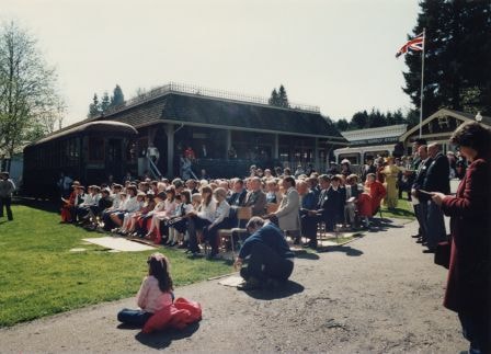
- Photograph of the opening of Seaforth School, Burnaby Village Museum. An annotation on the back of the photograph reads, "Dedication ceremony, Seaforth School, Bby Heritage Village, April 1987." A crowd of people is seated on chairs and standing at Burnaby Village Museum. Buildings and Tram #122…
- Repository
- City of Burnaby Archives
- Date
- April 1987
- Collection/Fonds
- Burnaby Historical Society fonds
- Subseries
- Donald N. Brown subseries
- Physical Description
- 1 photograph : col. ; 12.6 x 17.4 cm print
- Description Level
- Item
- Record No.
- 194-007
- Access Restriction
- No restrictions
- Reproduction Restriction
- Reproduce for fair dealing purposes only
- Accession Number
- BHS1987-03
- Scope and Content
- Photograph of the opening of Seaforth School, Burnaby Village Museum. An annotation on the back of the photograph reads, "Dedication ceremony, Seaforth School, Bby Heritage Village, April 1987." A crowd of people is seated on chairs and standing at Burnaby Village Museum. Buildings and Tram #1223 can be seen. The school was moved from its original location at 7881 Government Road to Burnaby Village Museum in 1983, and was opened to the public in 1987.
- Subjects
- Events - Openings
- Media Type
- Photograph
- Notes
- Title based on contents of photograph
- Geographic Access
- Deer Lake Avenue
- Street Address
- 6501 Deer Lake Avenue
- Historic Neighbourhood
- Burnaby Lake (Historic Neighbourhood)
- Planning Study Area
- Morley-Buckingham Area
Images

Seaforth School dedication ceremony
https://search.heritageburnaby.ca/link/archivedescription35129
- Repository
- City of Burnaby Archives
- Date
- April 1987
- Collection/Fonds
- Burnaby Historical Society fonds
- Description Level
- Item
- Physical Description
- 1 photograph : col. ; 12.6 x 17.4 cm print
- Scope and Content
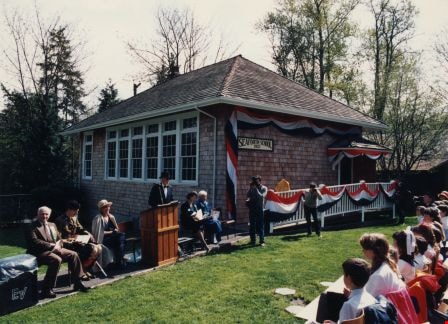
- Photograph of the opening of Seaforth School, Burnaby Village Museum. An annotation on the back of the photograph reads, "Dedication ceremony, Seaforth School, Bby Heritage Village, April 1987." People are seated in chairs outside a decorated Seaforth School looking toward a seated row of men and…
- Repository
- City of Burnaby Archives
- Date
- April 1987
- Collection/Fonds
- Burnaby Historical Society fonds
- Subseries
- Donald N. Brown subseries
- Physical Description
- 1 photograph : col. ; 12.6 x 17.4 cm print
- Description Level
- Item
- Record No.
- 194-006
- Access Restriction
- No restrictions
- Reproduction Restriction
- Reproduce for fair dealing purposes only
- Accession Number
- BHS1987-03
- Scope and Content
- Photograph of the opening of Seaforth School, Burnaby Village Museum. An annotation on the back of the photograph reads, "Dedication ceremony, Seaforth School, Bby Heritage Village, April 1987." People are seated in chairs outside a decorated Seaforth School looking toward a seated row of men and women, some of whom are in costume, by a microphone and podium. There are two photographers. The school was moved from its original location at 7881 Government Road to Burnaby Village Museum in 1983, and was opened to the public in 1987.
- Subjects
- Events - Openings
- Buildings - Schools
- Media Type
- Photograph
- Notes
- Title based on contents of photograph
- Geographic Access
- Deer Lake Avenue
- Street Address
- 6501 Deer Lake Avenue
- Historic Neighbourhood
- Burnaby Lake (Historic Neighbourhood)
- Planning Study Area
- Morley-Buckingham Area
Images
Siemens Track Vehicle
https://search.heritageburnaby.ca/link/archivedescription79399
- Repository
- City of Burnaby Archives
- Date
- October, 1976
- Collection/Fonds
- Burnaby Public Library Contemporary Visual Archive Project
- Description Level
- Item
- Physical Description
- 1 photograph : b&w ; 11 x 16 cm mounted on cardboard
- Scope and Content
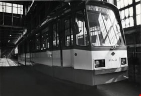
- Photograph shows Siemens track vehicle stored in the old Dominion Bridge building at the corner of Boundary Road and Lougheed Highway. According to the photographer, this vehicle was bought by BC Hydro under the NDP government (1972-1975) to initiate rapid transit but it was never used partly beca…
- Repository
- City of Burnaby Archives
- Date
- October, 1976
- Collection/Fonds
- Burnaby Public Library Contemporary Visual Archive Project
- Physical Description
- 1 photograph : b&w ; 11 x 16 cm mounted on cardboard
- Description Level
- Item
- Record No.
- 556-275
- Access Restriction
- No restrictions
- Reproduction Restriction
- Reproduce for fair dealing purposes only
- Accession Number
- 2013-13
- Scope and Content
- Photograph shows Siemens track vehicle stored in the old Dominion Bridge building at the corner of Boundary Road and Lougheed Highway. According to the photographer, this vehicle was bought by BC Hydro under the NDP government (1972-1975) to initiate rapid transit but it was never used partly because of the wrong gauge on existing rail lines.
- Subjects
- Transportation - Electric Railroads
- Media Type
- Photograph
- Photographer
- Cook, Alan
- Notes
- Scope note taken directly from BPL photograph description.
- 1 b&w copy negative : 10 x 12.5 cm accompanying
- Geographic Access
- Henning Drive
- Street Address
- 3880 Henning Drive
- Historic Neighbourhood
- Broadview (Historic Neighbourhood)
- Planning Study Area
- West Central Valley Area
Images

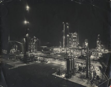
Standard Oil Stanovan Refinery
https://search.heritageburnaby.ca/link/archivedescription34566
- Repository
- City of Burnaby Archives
- Date
- 1958
- Collection/Fonds
- Burnaby Historical Society fonds
- Description Level
- Item
- Physical Description
- 1 photograph : b&w ; 27.8 x 35.3 cm
- Scope and Content
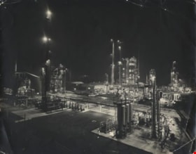
- Photograph of the Standard Oil Company Stanovan Refinery process area, Burrard Inlet. The area is lit up at night. Photograph of the Standard Oil Refinery at night. After the government broke up Standard Oil in 1911, its West Coast operations became the Standard Oil of California (SoCal), owning t…
- Repository
- City of Burnaby Archives
- Date
- 1958
- Collection/Fonds
- Burnaby Historical Society fonds
- Subseries
- Photographs subseries
- Physical Description
- 1 photograph : b&w ; 27.8 x 35.3 cm
- Description Level
- Item
- Record No.
- 052-002
- Access Restriction
- No restrictions
- Reproduction Restriction
- Reproduce for fair dealing purposes only
- Accession Number
- BHS2007-04
- Scope and Content
- Photograph of the Standard Oil Company Stanovan Refinery process area, Burrard Inlet. The area is lit up at night. Photograph of the Standard Oil Refinery at night. After the government broke up Standard Oil in 1911, its West Coast operations became the Standard Oil of California (SoCal), owning the Standard Oil Company of British Columbia Ltd, and adopting the name Chevron in the 1970's.
- Subjects
- Buildings - Industrial - Refineries
- Media Type
- Photograph
- Photographer
- Industrial Photographers
- Notes
- Title based on contents of photograph
- Geographic Access
- Eton Street
- Street Address
- 4403 Eton Street
- Historic Neighbourhood
- Vancouver Heights (Historic Neighbourhood)
- Planning Study Area
- Burnaby Heights Area
Images
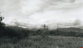
Still Creek
https://search.heritageburnaby.ca/link/archivedescription36510
- Repository
- City of Burnaby Archives
- Date
- 1950
- Collection/Fonds
- Burnaby Historical Society fonds
- Description Level
- Item
- Physical Description
- 1 photograph : b&w ; 8.5 x 14 cm
- Scope and Content
- Photograph of the Burnaby Lake bog taken from a small board walk that connected Sperling Avenue with a trail to Government Road at the west end of Burnaby Lake. Near the modern-day site of the Burnaby Lake Sports fields, this photograph was taken looking north west across Sperling Avenue and Still …
- Repository
- City of Burnaby Archives
- Date
- 1950
- Collection/Fonds
- Burnaby Historical Society fonds
- Subseries
- Photographs subseries
- Physical Description
- 1 photograph : b&w ; 8.5 x 14 cm
- Description Level
- Item
- Record No.
- 288-001
- Access Restriction
- No restrictions
- Reproduction Restriction
- Reproduce for fair dealing purposes only
- Accession Number
- BHS1992-23
- Scope and Content
- Photograph of the Burnaby Lake bog taken from a small board walk that connected Sperling Avenue with a trail to Government Road at the west end of Burnaby Lake. Near the modern-day site of the Burnaby Lake Sports fields, this photograph was taken looking north west across Sperling Avenue and Still Creek.
- Subjects
- Geographic Features - Bogs
- Names
- Still Creek
- Media Type
- Photograph
- Notes
- Title based on contents of photograph
- Photograph is a modern contact print of an original negative that was loaned to the Archives
- Geographic Access
- Still Creek
- Burnaby Lake
- Sperling Avenue
- Historic Neighbourhood
- Burnaby Lake (Historic Neighbourhood)
- Planning Study Area
- Douglas-Gilpin Area
Images

Stride family subseries
https://search.heritageburnaby.ca/link/archivedescription65848
- Repository
- City of Burnaby Archives
- Date
- 1900-1926
- Collection/Fonds
- Burnaby Historical Society fonds
- Description Level
- Subseries
- Physical Description
- Textual records and photographs
- Scope and Content
- Subseries consists of photographs and government records pertaining to the Stride family of Burnaby, including a tax demand and the booklet version of by-law no. 509.
- Repository
- City of Burnaby Archives
- Date
- 1900-1926
- Collection/Fonds
- Burnaby Historical Society fonds
- Subseries
- Stride family subseries
- Physical Description
- Textual records and photographs
- Description Level
- Subseries
- Accession Number
- BHS2007-04
- Scope and Content
- Subseries consists of photographs and government records pertaining to the Stride family of Burnaby, including a tax demand and the booklet version of by-law no. 509.
- History
- Eber Stride was born in Somerset England, one of three brothers, along with Albert and Sydney. Older brother Sydney came to Canada with Eber and Eber’s wife Mary in 1888 and settled in New Westminster. Both bricklayers by trade, Sydney soon began operating the brickyard at Queen’s Park. Mary McKinnon was born in Dorset, England on October 1, 1857. Her father, Hugh McKinnon worked as a coast guard. Mary worked as a school teacher in Somerset for nine years before marrying Eber Stride on April 28, 1888 and relocating to Canada. Eber and Mary were living at Royal Avenue in New Westminster when their first child Charles Edgar was born on February 24, 1890. Their second child, Edwin Hubert was born November 26, 1892. In May of 1893 the family of four moved to Burnaby. Their third child, Marguerite "Margaret" Ella, was born in Burnaby on April 2, 1895. The Stride family owned and operated Stride and Son Florist Green houses located at their residence at 1749 Kingsway (later renumbered 7434 Kingsway). Eber joined the municipal council a year after its incorporation and served for nineteen consecutive years; from 1894-1911 and again in 1913. Eber and Mary were life-long members of the St. Alban’s Anglican Church in Burnaby, dating back to the Churchs’ beginings. The Strides are considered Edmonds district pioneers. The Stride children attended Westside School and later Royal City High School. Both sons worked for the family florist business after they left school. Edwin continued working there, applying for a chauffeur licence renewal in September of 1916 at the age of twenty-three. Edwin and Eber operated the business together for over 40 years. Charles Edgar didn’t stay a florist long. Instead, he had a brief career building houses before travelling to San Francisco by bicycle with a friend to attend the World’s Fair. He continued on to Tijuana, Mexico before heading home to join the Reserves and head overseas. Once back in New Westminster, Charles Edgar opened a series of photographic studios along Columbia Street. His first studio was Universal Photographers, operating from 1918 to 1925. He opened Brighton Studios at 657 Columbia Street as well from 1924 to 1925. In 1926 he opened Stride Studios at 657 Columbia Street, which thrived until 1968 when an unfortunate fire in a neighbouring business destroyed most of his prints and negatives. In 1928 he bought Columbia Studio across the street at 624 Columbia Street and owned it anonymously until 1960. For thirty years, no one knew that he owned both businesses and was able to send disgruntled customers “across the street to the competition.” Margaret Stride married and became Margaret Hokanson. Mary Stride died September 24, 1933 at the age of 75. Eber died November 8, 1942 at the age of 84. Edwin died April 16, 1970 at the age of 77. Charles Edgar died February 29, 1972 at the age of 82. Stride Avenue in Burnaby was named after Eber Stride.
- Media Type
- Photograph
- Textual Record
- Creator
- Stride, Charles Edgar
- Stride, Eber
- Notes
- MSS004 and PC001
- Title based on contents of subseries
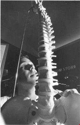
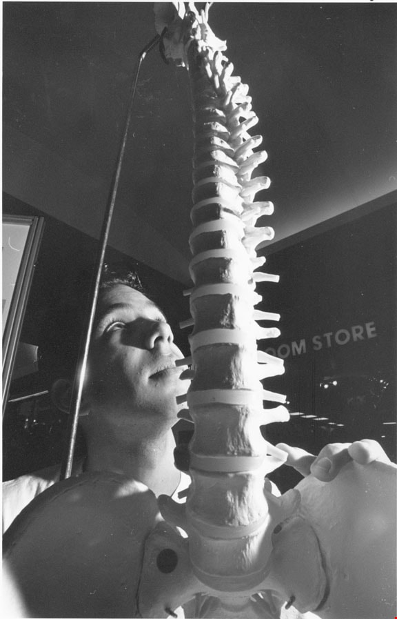
Taki Galonopoulos
https://search.heritageburnaby.ca/link/archivedescription78662
- Repository
- City of Burnaby Archives
- Date
- October 22, 1995
- Collection/Fonds
- Burnaby NewsLeader photograph collection
- Description Level
- Item
- Physical Description
- 1 photograph : b&w ; 23.5 x 15 cm
- Scope and Content
- Photograph of Taki Galonopoulos, a fourth year kinesiology student at Simon Fraser University examining a model of a human spine while visiting the Science and Technology Showcase at Metrotown. The event was sponsored by the City of Burnaby, Simon Fraser University and the provincial government.
- Repository
- City of Burnaby Archives
- Date
- October 22, 1995
- Collection/Fonds
- Burnaby NewsLeader photograph collection
- Physical Description
- 1 photograph : b&w ; 23.5 x 15 cm
- Description Level
- Item
- Record No.
- 535-0023
- Access Restriction
- No restrictions
- Reproduction Restriction
- No reproduction permitted
- Accession Number
- 2012-11
- Scope and Content
- Photograph of Taki Galonopoulos, a fourth year kinesiology student at Simon Fraser University examining a model of a human spine while visiting the Science and Technology Showcase at Metrotown. The event was sponsored by the City of Burnaby, Simon Fraser University and the provincial government.
- Names
- Galonopoulos, Taki
- Media Type
- Photograph
- Photographer
- Bartel, Mario
- Notes
- Title based on contents of photograph
- Note in black and blue ink on recto of photograph reads: "2841 A Mario Bby / 10/22 BNW p. 15 80%"
- Trim marks and/or reproduction instructions on recto (scan is cropped)
- Geographic Access
- Kingsway
Images
Walker family fonds
https://search.heritageburnaby.ca/link/archivedescription78708
- Repository
- City of Burnaby Archives
- Date
- 1948-1957 (date of originals); 2013
- Collection/Fonds
- Walker family fonds
- Description Level
- Fonds
- Physical Description
- 38 photographs (7 jpeg : col., 300 dpi ; 7 jpeg : col., 96 dpi ; 10 jpeg : b&w, 300 dpi ; 12 jpeg : b&w, 96 dpi). 1 drawing (jpeg) : col., 300 dpi ; 2 maps (jpeg) : col. ; 96 dpi ; 397.67 KB of textual records.
- Scope and Content
- Fonds consists of 41 jpegs of original photographs (some include annotation), maps, and newspaper clippings pertaining to Scotty Walker, his family and the Inter-City Driving Range that he created.
- Repository
- City of Burnaby Archives
- Date
- 1948-1957 (date of originals); 2013
- Collection/Fonds
- Walker family fonds
- Physical Description
- 38 photographs (7 jpeg : col., 300 dpi ; 7 jpeg : col., 96 dpi ; 10 jpeg : b&w, 300 dpi ; 12 jpeg : b&w, 96 dpi). 1 drawing (jpeg) : col., 300 dpi ; 2 maps (jpeg) : col. ; 96 dpi ; 397.67 KB of textual records.
- Description Level
- Fonds
- Access Restriction
- No restrictions
- Reproduction Restriction
- May be restricted by third party rights
- Accession Number
- 2013-15
- Scope and Content
- Fonds consists of 41 jpegs of original photographs (some include annotation), maps, and newspaper clippings pertaining to Scotty Walker, his family and the Inter-City Driving Range that he created.
- History
- Scotty Walker purchased the property at 974 12th Avenue in 1948 under the Veteran’s Land Act (VLA) grant from the government. He was in the Air Force during the Second World War. Previous to the purchase he ran a trucking business in New Westminster and lived at 1421 Nanaimo Street. The family consisted of Scotty, his wife Elizabeth, and three children, Alex, Barbara, and James. The land was overgrown with trees, scrub bushes, and a general swampy area. Scotty had the plan to build a Golf Driving Range, but it would take a lot of work. He owned three acres and leased three acres from the Lady of Mercy Church. Then they started working the land. The trees and scrub bush had to be removed and it was all done by hand. As the weather warmed and the swamp dried somewhat, Scotty got the idea to do selective burning. After many times doing this in small sections, the wind changed and the fire was headed for some houses on Tenth Avenue. The fire departments from New Westminster and Burnaby showed up and he was severely punished. It created other problems too. The land was swampy and when it dried, it was a peat bog, so the fire would burn down and turn up all over the place. That winter when the rains came, the land flooded and froze. The kids in the neighbourhood took advantage of the open spaces and brought out their skates. They had a great time. Some pigs were purchased with the idea that they could help dig up the roots and could be butchered later. Well they cleared the roots, but the kids all said they would not eat the pigs. The pigs were sold as they had become like pets. The land was then bulldozed into a berm on the 12th Street side of the land and a fence was built on top of the hill. The Walkers still had to clear the roots and branches that accumulated on the berm. The big problem was snakes. There were pits of water snakes that had been moved with the bulldozing. The family is not sure what happened with the snakes but eventually they moved. The area that would have been to the left of the property was still a swamp, so maybe they went there. The Walkers built drainage ditches through the land and let it drain to the natural slope toward Eighth Street. Construction on the Golf Range started and the grass was seeded. The “Inter-City Golf Range” opened on June 16, 1951. It had been a long hard road for the whole family but it worked out quite well. There was no automatic machine picking up balls, it was all done by hand and washed in a washing machine. Eventually they got Shag Bags that helped some but it was a huge job. The Golf Range ran for a few years and then Burnaby had a very sunny summer and the sun was in the patrons' eyes. So Scotty decided to move the buildings to the 12th Avenue part of the land. The club house and coffee shop was moved. The family took the building apart board by board and reconstructed it at the other end of the land. This worked well. All this had been accomplished on a shoestring budget as there was no big money behind anything. The Walkers cut the grass with gas hand mowers, washed the balls with the washing machine, and worked very long hours. Then the Catholic Church decided not to renew the lease. The family had worked so hard and now Scotty’s dream was dashed. It was a devastating time. Eventually the property was sold to the Christian Brothers and the buildings to Gus Brown in Richmond. The church bought the land for $25,000, in 1957. The end of the dream was very hard on everyone. Eventually life went on. It is sad that Scotty was just so far ahead of his time. He was a small man about 5’6" and about 140 pounds but had dreams as big as anyone and worked like three men to accomplish his dream. The cleared land was eventually developed into Saint Thomas Moore School. Biography provided by B. Kromm
- Media Type
- Photograph
- Creator
- Walker family
- Notes
- Title based on contents of fonds
- Photo catalogue 557

Widening of Scott Road
https://search.heritageburnaby.ca/link/archivedescription56677
- Repository
- City of Burnaby Archives
- Date
- March 1976, published March 24, 1976
- Collection/Fonds
- Columbian Newspaper collection
- Description Level
- Item
- Physical Description
- 1 photograph : b&w ; 7.5 x 14 cm
- Scope and Content
- Photograph of the process of widening Scott Road in Surrey BC. The process was undertaken by the provincial government. Citizens were upset as this process included cutting down century-old trees (stumps of these former trees are visible in this photograph).
- Repository
- City of Burnaby Archives
- Date
- March 1976, published March 24, 1976
- Collection/Fonds
- Columbian Newspaper collection
- Physical Description
- 1 photograph : b&w ; 7.5 x 14 cm
- Description Level
- Item
- Record No.
- 480-531
- Access Restriction
- No restrictions
- Reproduction Restriction
- No restrictions
- Accession Number
- 2003-02
- Scope and Content
- Photograph of the process of widening Scott Road in Surrey BC. The process was undertaken by the provincial government. Citizens were upset as this process included cutting down century-old trees (stumps of these former trees are visible in this photograph).
- Media Type
- Photograph
- Photographer
- King, Basil
- Notes
- Title based on contents of photograph
- Newspaper clipping attached to verso of photograph reads: "Road-widening on Scott Rd. in Surrey has taken its toll of old trees."
Images

Burnaby Public Library Board subseries
https://search.heritageburnaby.ca/link/archivedescription96372
- Repository
- City of Burnaby Archives
- Date
- [1960]-2007
- Collection/Fonds
- City Council and Office of the City Clerk fonds
- Description Level
- Subseries
- Physical Description
- 3 rolls of microfilm + 1 photograph
- Scope and Content
- Subseries consists of board records for the Burnaby Public Library Board, including appointments, correspondence, and a comissioned portrait.
- Repository
- City of Burnaby Archives
- Date
- [1960]-2007
- Collection/Fonds
- City Council and Office of the City Clerk fonds
- Series
- Council Committee series
- Subseries
- Burnaby Public Library Board subseries
- Physical Description
- 3 rolls of microfilm + 1 photograph
- Description Level
- Subseries
- Scope and Content
- Subseries consists of board records for the Burnaby Public Library Board, including appointments, correspondence, and a comissioned portrait.
- History
- The Burnaby Public Library Board was established in 1955. The Trustees on the Burnaby Public Library Board govern the Burnaby Public Library and provide policies, a mission and vision, and general library management.
- Media Type
- Textual Record
- Photograph
- Graphic Material
![Derek Corrigan at Burnaby Justice Building, [2002] thumbnail](/media/hpo/_Data/_Archives_Images/_Unrestricted/535/535-2925.jpg?width=280)
Derek Corrigan at Burnaby Justice Building
https://search.heritageburnaby.ca/link/archivedescription97626
- Repository
- City of Burnaby Archives
- Date
- [2002]
- Collection/Fonds
- Burnaby NewsLeader photograph collection
- Description Level
- Item
- Physical Description
- 1 photograph (tiff) : col.
- Scope and Content
- Photograph of City of Burnaby councillor Derek Corrigan posing outside of the Burnaby Justice Building next to a sign directing to the Justice Law Courts.
- Repository
- City of Burnaby Archives
- Date
- [2002]
- Collection/Fonds
- Burnaby NewsLeader photograph collection
- Physical Description
- 1 photograph (tiff) : col.
- Description Level
- Item
- Record No.
- 535-2925
- Access Restriction
- No restrictions
- Reproduction Restriction
- No restrictions
- Accession Number
- 2018-12
- Scope and Content
- Photograph of City of Burnaby councillor Derek Corrigan posing outside of the Burnaby Justice Building next to a sign directing to the Justice Law Courts.
- Subjects
- Officials - Aldermen and Councillors
- Officials - Mayors and Reeves
- Buildings - Judicial - Courthouses
- Names
- Corrigan, Derek
- Media Type
- Photograph
- Photographer
- Bartel, Mario
- Notes
- Title based on caption
- Collected by editorial for use in a January 2002 issue of the Burnaby NewsLeader
- Caption from metadata: "Burnaby councillor, and lawyer, Derek Corrigan, is upset over the provincial government's plan to close the city's courthouse. He's leding a debate about the issue at Monday's city council meeting."
- Geographic Access
- Canada Way
- Street Address
- 4946 Canada Way
- Historic Neighbourhood
- Burnaby Lake (Historic Neighbourhood)
- Planning Study Area
- Douglas-Gilpin Area
Images
![Derek Corrigan at Burnaby Justice Building, [2002] thumbnail](/media/hpo/_Data/_Archives_Images/_Unrestricted/535/535-2925.jpg)
Flag waving at the March of the Clans
https://search.heritageburnaby.ca/link/archivedescription36311
- Repository
- City of Burnaby Archives
- Date
- 1951
- Collection/Fonds
- Burnaby Historical Society fonds
- Description Level
- Item
- Physical Description
- 1 photograph : b&w ; 24.5 x 18.5 cm
- Scope and Content
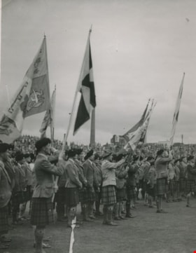
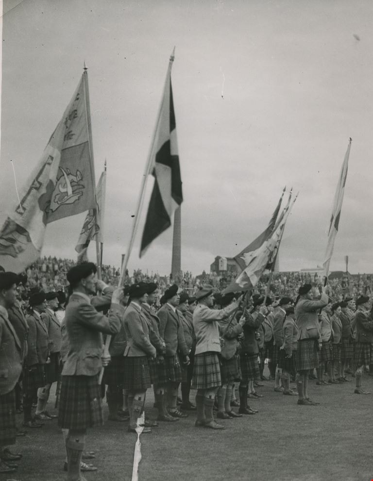
- Photograph of the March of the Clans in Edinburgh organised by Lord MacPherson of Drumochter at the government's behest. This is taken at the side of the road, looking into the crowd of men waving flags. George A. and Alice Grant of Burnaby attended this event.
- Repository
- City of Burnaby Archives
- Date
- 1951
- Collection/Fonds
- Burnaby Historical Society fonds
- Subseries
- George Grant subseries
- Physical Description
- 1 photograph : b&w ; 24.5 x 18.5 cm
- Description Level
- Item
- Record No.
- 243-031
- Access Restriction
- No restrictions
- Reproduction Restriction
- Reproduce for fair dealing purposes only
- Accession Number
- BHS1990-06
- Scope and Content
- Photograph of the March of the Clans in Edinburgh organised by Lord MacPherson of Drumochter at the government's behest. This is taken at the side of the road, looking into the crowd of men waving flags. George A. and Alice Grant of Burnaby attended this event.
- Subjects
- Events - Parades
- Symbols - Flags
- Clothing
- Media Type
- Photograph
- Photographer
- Outram, George
- Notes
- Title based on contents of photograph
- Stamp on verso of print reads: "GEORGE OUTRAM & CO. LTD. 65 BUCHANAN STREET GLASGOW, C.1."
- Photographer identifies photograph as no. B156Y-A
Images
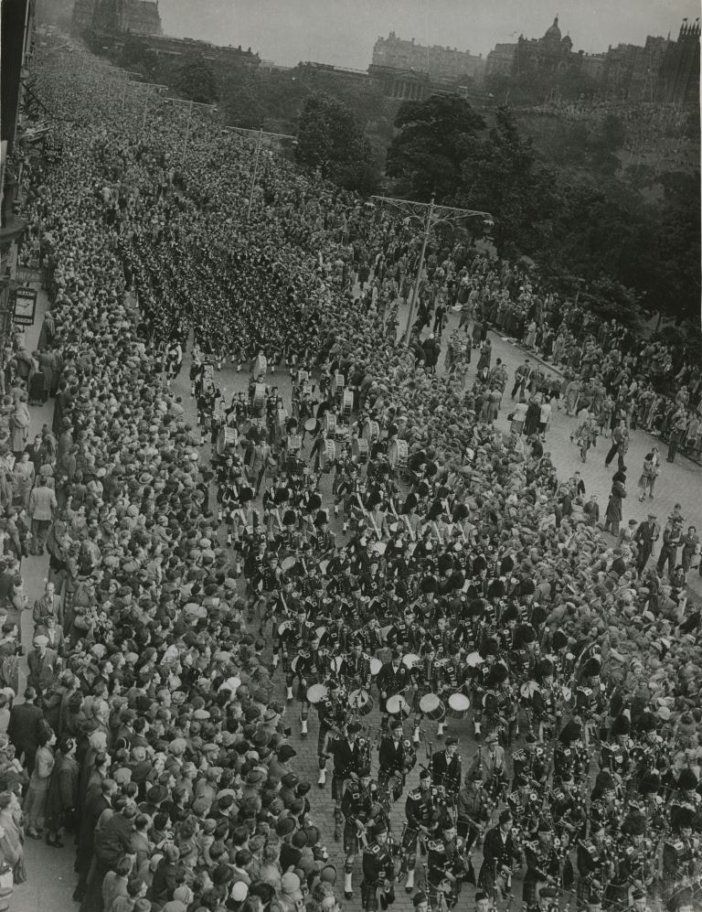
The March of the Clans
https://search.heritageburnaby.ca/link/archivedescription36308
- Repository
- City of Burnaby Archives
- Date
- 1951
- Collection/Fonds
- Burnaby Historical Society fonds
- Description Level
- Item
- Physical Description
- 1 photograph : b&w ; 24.5 x 18.5 cm
- Scope and Content
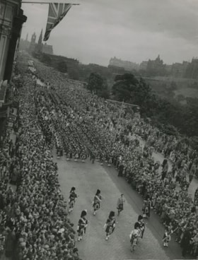
- Photograph of the March of the Clans in Edinburgh organised by Lord MacPherson of Drumochter at the government's behest. This is an aerial view of the march, with spectators lined up as far as the eye can see. George A. and Alice Grant of Burnaby attended this event.
- Repository
- City of Burnaby Archives
- Date
- 1951
- Collection/Fonds
- Burnaby Historical Society fonds
- Subseries
- George Grant subseries
- Physical Description
- 1 photograph : b&w ; 24.5 x 18.5 cm
- Description Level
- Item
- Record No.
- 243-028
- Access Restriction
- No restrictions
- Reproduction Restriction
- Reproduce for fair dealing purposes only
- Accession Number
- BHS1990-06
- Scope and Content
- Photograph of the March of the Clans in Edinburgh organised by Lord MacPherson of Drumochter at the government's behest. This is an aerial view of the march, with spectators lined up as far as the eye can see. George A. and Alice Grant of Burnaby attended this event.
- Subjects
- Events - Parades
- Media Type
- Photograph
- Photographer
- Outram, George
- Notes
- Title based on contents of photograph
- Stamp on verso of print reads: "GEORGE OUTRAM & CO. LTD. 65 BUCHANAN STREET GLASGOW, C.1."
- Photographer identifies photograph as no. B1556-G
Images

The March of the Clans
https://search.heritageburnaby.ca/link/archivedescription36310
- Repository
- City of Burnaby Archives
- Date
- 1951
- Collection/Fonds
- Burnaby Historical Society fonds
- Description Level
- Item
- Physical Description
- 1 photograph : b&w ; 24.5 x 18.5 cm
- Scope and Content
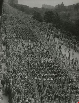
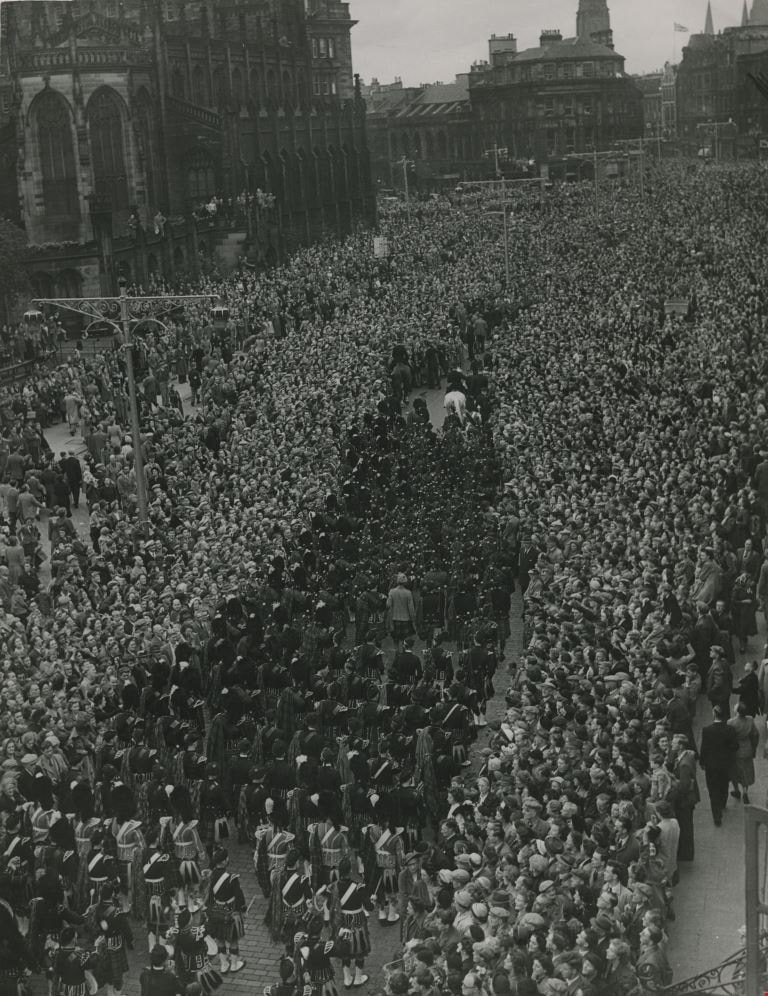
- Photograph of the March of the Clans in Edinburgh organised by Lord MacPherson of Drumochter at the government's behest. This is an aerial view of the drumming section of a marching band, with spectators lined up as far as the eye can see. George A. and Alice Grant of Burnaby attended this event.
- Repository
- City of Burnaby Archives
- Date
- 1951
- Collection/Fonds
- Burnaby Historical Society fonds
- Subseries
- George Grant subseries
- Physical Description
- 1 photograph : b&w ; 24.5 x 18.5 cm
- Description Level
- Item
- Record No.
- 243-030
- Access Restriction
- No restrictions
- Reproduction Restriction
- Reproduce for fair dealing purposes only
- Accession Number
- BHS1990-06
- Scope and Content
- Photograph of the March of the Clans in Edinburgh organised by Lord MacPherson of Drumochter at the government's behest. This is an aerial view of the drumming section of a marching band, with spectators lined up as far as the eye can see. George A. and Alice Grant of Burnaby attended this event.
- Subjects
- Events - Parades
- Media Type
- Photograph
- Photographer
- Outram, George
- Notes
- Title based on contents of photograph
- Stamp on verso of print reads: "GEORGE OUTRAM & CO. LTD. 65 BUCHANAN STREET GLASGOW, C.1."
- Photographer identifies photograph as no. B1556-B
Images
The March of the Clans
https://search.heritageburnaby.ca/link/archivedescription36312
- Repository
- City of Burnaby Archives
- Date
- 1951
- Collection/Fonds
- Burnaby Historical Society fonds
- Description Level
- Item
- Physical Description
- 1 photograph : b&w ; 24.5 x 18.5 cm
- Scope and Content
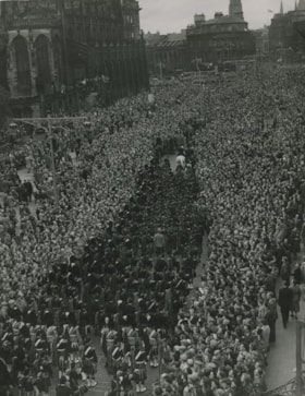
- Photograph of the March of the Clans in Edinburgh organised by Lord MacPherson of Drumochter at the government's behest. This is an aerial view of the backs of the marching musicians, with spectators lined up as far as the eye can see. George A. and Alice Grant of Burnaby attended this event.
- Repository
- City of Burnaby Archives
- Date
- 1951
- Collection/Fonds
- Burnaby Historical Society fonds
- Subseries
- George Grant subseries
- Physical Description
- 1 photograph : b&w ; 24.5 x 18.5 cm
- Description Level
- Item
- Record No.
- 243-032
- Access Restriction
- No restrictions
- Reproduction Restriction
- Reproduce for fair dealing purposes only
- Accession Number
- BHS1990-06
- Scope and Content
- Photograph of the March of the Clans in Edinburgh organised by Lord MacPherson of Drumochter at the government's behest. This is an aerial view of the backs of the marching musicians, with spectators lined up as far as the eye can see. George A. and Alice Grant of Burnaby attended this event.
- Subjects
- Events - Parades
- Media Type
- Photograph
- Photographer
- Outram, George
- Notes
- Title based on contents of photograph
- Stamp on verso of print reads: "GEORGE OUTRAM & CO. LTD. 65 BUCHANAN STREET GLASGOW, C.1."
- Photographer identifies photograph as no. B1556-H
Images
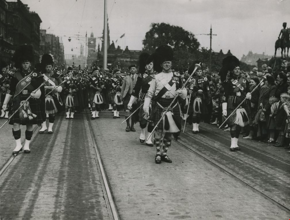
Pipe band at the March of the Clans
https://search.heritageburnaby.ca/link/archivedescription36309
- Repository
- City of Burnaby Archives
- Date
- 1951
- Collection/Fonds
- Burnaby Historical Society fonds
- Description Level
- Item
- Physical Description
- 1 photograph : b&w ; 18.5 x 24.5 cm
- Scope and Content
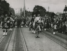
- Photograph of the March of the Clans in Edinburgh organised by Lord MacPherson of Drumochter at the government's behest. This is taken in the center of the road as one of the Pipe bands marches towards the camera. George A. and Alice Grant of Burnaby attended this event.
- Repository
- City of Burnaby Archives
- Date
- 1951
- Collection/Fonds
- Burnaby Historical Society fonds
- Subseries
- George Grant subseries
- Physical Description
- 1 photograph : b&w ; 18.5 x 24.5 cm
- Description Level
- Item
- Record No.
- 243-029
- Access Restriction
- No restrictions
- Reproduction Restriction
- Reproduce for fair dealing purposes only
- Accession Number
- BHS1990-06
- Scope and Content
- Photograph of the March of the Clans in Edinburgh organised by Lord MacPherson of Drumochter at the government's behest. This is taken in the center of the road as one of the Pipe bands marches towards the camera. George A. and Alice Grant of Burnaby attended this event.
- Subjects
- Events - Parades
- Media Type
- Photograph
- Photographer
- Outram, George
- Notes
- Title based on contents of photograph
- Stamp on verso of print reads: "GEORGE OUTRAM & CO. LTD. 65 BUCHANAN STREET GLASGOW, C.1."
- Photographer identifies photograph as no. B1556-E
Images
Burnaby Art Gallery subseries
https://search.heritageburnaby.ca/link/archivedescription14
- Repository
- City of Burnaby Archives
- Date
- 1890 (date of original)-1983
- Collection/Fonds
- Burnaby Historical Society fonds
- Description Level
- Subseries
- Physical Description
- Photographs and textual records
- Scope and Content
- Subseries consists of photographs of and publications related to the Burnaby Art Gallery and Fairacres property.
- Repository
- City of Burnaby Archives
- Date
- 1890 (date of original)-1983
- Collection/Fonds
- Burnaby Historical Society fonds
- Subseries
- Burnaby Art Gallery subseries
- Physical Description
- Photographs and textual records
- Description Level
- Subseries
- Accession Number
- BHS1996-12
- BHS1990-05
- Scope and Content
- Subseries consists of photographs of and publications related to the Burnaby Art Gallery and Fairacres property.
- History
- The Burnaby Art Gallery association was founded in 1967. The purpose of the association was to present a historical and contemporary art program by local, regional, national, and international artists; facilitate the development of emerging artists; provide diverse art educational programming; acquire culturally significant works on paper. The City of Burnaby assumed management of the gallery, its collection, staff and governance in 1998, with the art gallery then taking on the added responsibility of caring for and managing the City of Burnaby’s permanent art collection. The Gallery, along with the Shadbolt Centre for the Arts and the Burnaby Village Museum in Deer Lake Park, are part of the Parks, Recreation and Cultural Services Department of the City of Burnaby. The Burnaby Art Gallery is located inside the historic Ceperley House, built by Henry and Grace Ceperley. The couple purchased a strawbery farm on the north shore of Deer Lake from George Clayton in 1909 and built their home, also known as "Fairacres", on the property in 1911. The house was designed by the English architect, R.P.S. Twizell and with its river rock veranda, beautiful hand-crafted woodwork, stained-glass and tile, remains one of the finest examples of Edwardian architecture in the Lower Mainland. Grace and Hentry Ceperley had one daughter named Ethelwyn who married James Edward Hall. Ethelwyn and James Edward Hall had three children: Edith Ceperley, James Edward "Junior," and Florence Renn. In 1917, Grace Ceperley died and left Fairacres to her husband with the stipulation that when the home was sold the proceeds would be used to build a playground for the children of Vancouver in Stanley Park. In 1939, the local Catholic Diocese funded a group of five Benedictine monks from Mount Angel, Oregon to establish a priory in the province. The monks purchased the Ceperley House for their monastery. They also built a large gymnasium on the property. After serving as a monastery, the house was used as a fraternity for some of the first students attending Simon Fraser University, and then became home to the art gallery in the 1960s. The City of Burnaby acquired the property in 1966 and the house was designated a heritage building in 1992. In 1998 the City began restoring exterior of the house and upgraded the building for improved public use. The renovations were completed in 2000, and transformed the house back to its appearance of 1911. The gymnasium built by the Benedictine monks was converted into into the James Cowan Theatre. There are two main galleries, a lounge gallery with a fireplace and easy chairs and The Shopping Bag, a gallery shop run by volunteers. The goals of the gallery are to: provide access to contemporary Canadian art, present works from the permanent collection; collect contemporary works on paper; and offer challenging and educational exhibition related programming.
- Media Type
- Textual Record
- Photograph
- Creator
- Burnaby Art Gallery
- Notes
- Title based on contents of subseries
- PC241, PC242, MSS066
Hazel Simnett collection
https://search.heritageburnaby.ca/link/archivedescription71379
- Repository
- City of Burnaby Archives
- Date
- [1910-1996]
- Collection/Fonds
- Hazel Simnett collection
- Description Level
- Fonds
- Physical Description
- 13 files of textual records : ill. (some col.) ; 9 paintings : colour print ; 2 photographs : b&w
- Scope and Content
- Fonds consists of City-generated records, personal records, and political records collected by Hazel Simnett.
- Repository
- City of Burnaby Archives
- Date
- [1910-1996]
- Collection/Fonds
- Hazel Simnett collection
- Physical Description
- 13 files of textual records : ill. (some col.) ; 9 paintings : colour print ; 2 photographs : b&w
- Description Level
- Fonds
- Accession Number
- 2013-22
- 2012-03
- Scope and Content
- Fonds consists of City-generated records, personal records, and political records collected by Hazel Simnett.
- History
- Hazel Simnett was born in Burnaby in 1922 to Frederick and Mary Ann Simnett and grew up looking up to her father who was very involved in labour and unions. A politically active citizen, Hazel Simnett has supported the Canadian Commonwealth Federation (CCF) and the New Democratic Party (NDP). She once ran as a New Democratic Party candidate for Burnaby City Council. Hazel attended Kingsway West Public School and Burnaby South High School in Burnaby. During the 1970s, Hazel was President of the Century Park Museum Association, which governs Burnaby Heritage Museum and published the work "Bygones of Burnaby". Hazel worked on the campaign team of Joan Sawicki from 1990 to 1991, which led Sawicki to be elected as Burnaby-Willingdon riding's MLA. Hazel volunteered her time to be a member of the Burnaby Advisory Planning Commission from 1993 to 1996. In 2006, Hazel won the Burnaby Local Hero Award for her volunteer work at the New Vista Society where she served as chair for a number of years. She also served as a member of the Burnaby Historical Society and established the Hazel Simnett Endowment with the Burnaby Public Library to bring a collection of books on Canadian history and social issues.
- Media Type
- Textual Record
- Photograph
- Graphic Material
- Creator
- Simnett, Hazel
- Notes
- Title based on contents of fonds
- MSS167

Norman Bethune Housing Cooperative
https://search.heritageburnaby.ca/link/archivedescription56667
- Repository
- City of Burnaby Archives
- Date
- November 1976
- Collection/Fonds
- Columbian Newspaper collection
- Description Level
- Item
- Physical Description
- 1 photograph : b&w ; 15 x 19.5 cm
- Scope and Content
- Photograph of Larry Whaley, then president of the Norman Bethune Housing Cooperative, standing outside the housing complex where he lived. At the time, only 24 units were inhabited by members while the other 282 units that were supposed to be opened up in the second stage of the project were vacant…
- Repository
- City of Burnaby Archives
- Date
- November 1976
- Collection/Fonds
- Columbian Newspaper collection
- Physical Description
- 1 photograph : b&w ; 15 x 19.5 cm
- Description Level
- Item
- Record No.
- 480-1253
- Access Restriction
- No restrictions
- Reproduction Restriction
- No restrictions
- Accession Number
- 2003-02
- Scope and Content
- Photograph of Larry Whaley, then president of the Norman Bethune Housing Cooperative, standing outside the housing complex where he lived. At the time, only 24 units were inhabited by members while the other 282 units that were supposed to be opened up in the second stage of the project were vacant due to a misunderstanding between the provincial and federal governments, and the allocation of nine million dollars that had been sent aside in 1973 for for rental housing in Burnaby.
- Names
- Whaley, Larry
- Media Type
- Photograph
- Photographer
- King, Basil
- Notes
- Title based on contents of photograph
- Newspaper clipping attached to verso of photograph reads: "Larry Whaley ponders what will happen to Bethune Co-Op Housing in Simon Fraser Hills area."
- Geographic Access
- Centaurus Circle
- Street Address
- 8752 Centaurus Circle
- Historic Neighbourhood
- Burquitlam (Historic Neighbourhood)
- Planning Study Area
- Lyndhurst Area
Images

Planning Department fonds
https://search.heritageburnaby.ca/link/archivedescription102
- Repository
- City of Burnaby Archives
- Date
- 1940-2016
- Collection/Fonds
- Planning Department fonds
- Description Level
- Fonds
- Physical Description
- 80 m of textual records and other material
- Scope and Content
- Fonds consists of those records created during the regular conduct of business by the Planning Department and its predecessor agencies according to their mandate of providing professional and technical advice to Council on the current and future uses of City land and resources.
- Repository
- City of Burnaby Archives
- Date
- 1940-2016
- Collection/Fonds
- Planning Department fonds
- Physical Description
- 80 m of textual records and other material
- Description Level
- Fonds
- File Class
- 71000 10 (add. 2020)
- 71000 20 (add. 2020)
- 71000 30 (add. 2020)
- 71000 40 (add. 2020)
- Access Restriction
- Subject to FOIPPA
- Reproduction Restriction
- Reproductions subject to FOIPPA.
- Scope and Content
- Fonds consists of those records created during the regular conduct of business by the Planning Department and its predecessor agencies according to their mandate of providing professional and technical advice to Council on the current and future uses of City land and resources.
- History
- The City of Burnaby Planning Department was established on October 9, 1956, when the City Council unanimously carried the motion to create a distinct department to deal with planning issues within the City and appointed Mr. William John Blakely as its head. This decision followed a report and recommendation made by the City’s Chief Administrative Officer which indicated that the role of the Planning Engineer and his staff had quickly expanded to become a separate division within the Engineering Department and that they were functioning as an independent unit in all but name. The proposed separation of the Engineering and Planning departments had been in the works since the early part of 1956 when staff changes and restructuring within the Engineering Department’s Planning Division illustrated the undermanned condition of the Planning Engineer’s office. As a result, Council asked the Chief Administrative Officer to undertake a study examining the feasibility of creating a distinct Planning Department. This report was delivered to Council on July 3, 1956, but was laid over until a Committee of the Council had the opportunity to study the functions of the Planning department to determine the necessity of the proposal. The Committee’s findings were in line with the initial report and the Planning Department was established with a staff of nine (the head Planning Engineer, an Administrative Planner, three Research Planning Assistants, a Draughtsman, a Subdivision Control Clerk, a department Clerk and a Clerk Stenographer). This new department was to offer advice and carry out the work intensive in matters such as zoning and rezoning applications, subdivision control, traffic and transportation planning, and general City planning schemes. Prior to the creation of the Planning Department, a number of bodies within the City had been responsible for fulfilling the functions carried out by this new unit. In the earliest years of the City, the members of Council were responsible for matters of planning and were assisted in their job by the City’s Engineer or any number of hired consultants (e.g. surveyors, cartographers). By 1906, however, the provincial laws surrounding the subdivision process had changed, and local governments were charged with the task of approving all private subdivision plans in their respective Municipalities. In Burnaby, the City Council passed a bylaw decreeing that all subdivision plans were to be submitted to Council for review and the City Engineer was responsible for ensuring compliance with the law. After the first Town Planning Bylaw in 1924 which restricted the type and size of construction that could occur in certain City areas, the Engineering and Building departments were to work together to oversee the enforcement of the Bylaw and the development of City plans. The scope and competence required to carry out this work grew as Burnaby’s population expanded, and in 1930 Council passed the Town Planning Commission Bylaw (No. 1028) that saw the creation of a permanent body – the Town Planning Commission – which was to serve as an advisory body to help direct the planning activities in the City while the actual work continued to be carried out by the Engineering Department. This body was comprised of the Reeve, the Chairman of the School Board, the Chairman of the Park Committee (later, the Board of Parks Commissioners), and six appointed citizens who served three-year terms. Council referred all matters of subdivisions, transportation planning, and rezoning to this Commission, which was later supported in its work by several other special or standing committees such as the Subdivision Committee, the Apartment Committee, the Transportation Committee or the Town Planning Board of Appeal. By 1953, it had become apparent that the advisory committees that were dedicated to these planning issues needed a permanent staff to carry out the work intensive, so a restructuring of the Engineering department resulted in a permanent Planning Engineer’s office being created. The Town Planning Commission continued in its advisory capacity even after the determination came in 1956 to create a separate Planning Department. When Bylaw No. 4473 was passed in 1963, the Town Planning Commission was disbanded in favour of a new Advisory Planning Commission that would turn over all routine matters such as subdivision and rezoning applications to the Planning Department but would offer advice and community input into the more complex planning schemes within the City and act as an intermediary in cases where Council and Planning staff were in disagreement. A new Advisory Planning Commission Bylaw (No. 7600) was adopted in 1980 which allowed for even greater community participation in the planning process. The Planning Department was initially responsible to report directly to Council, but in 1957, the administrative structure of Municipal staff changed with the introduction of the Burnaby Municipal Manager Bylaw (No. 3859) and from that point on, the head of the Planning Department held a direct reporting relationship to the Municipal Manager, who in turn was responsible for reporting the activities of the Department to the City Council. Over the years, the internal structure and the scope of responsibilities of the Department have changed during periods of staff reorganizations. Under the larger umbrella of the Planning and Building Department, Planning has come to be comprised of two divisions: the Current Planning Division and the Long Range Planning Division. The functions of the Current Planning Division include rezoning, subdivision, development plan areas, preliminary plan approvals, urban design, heritage planning, and urban trails and bicycle routes. The Long Range Planning Division is responsible for environmental planning concerns, transportation planning, housing, neighbourhood area planning, social planning and planning information services. In 2022, the Planning and Building Department was reorganized to better align functions with delivery of services. The Climate Action and Engery Division moved from Corporate Services to the Planning and Building Department, while Indigenous Relations and Facilities Management moved to Corporate Services and Lands and Facilities, respectively. The position of Director of Planning and Building was changed to General Manager, Planning and Development. The following individuals have served as Planning Engineer and/or Director of the Planning Department and/or General Manager, Planning and Development for the City of Burnaby: William John Blakely 1954-1956 (as Planning Engineer) 1956-1963 (as Head of the Department) Anthony P. Parr 1964-1993 Don G. Stenson 1993-2001 Jack S. Belhouse 2001-2006 Basil Luksun 2006-2012 Lou Pelletier 2012-2019 Edward Kozak 2019-present
- Formats
- Microforms exist for some records. See series descriptions.
- Media Type
- Textual Record
- Photograph
- Moving Images
- Creator
- City of Burnaby
- Notes
- Title based on contents of fonds