Narrow Results By
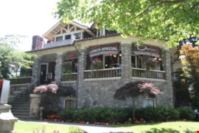
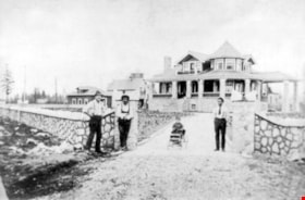
Andy Johnson House
https://search.heritageburnaby.ca/link/landmark515
- Repository
- Burnaby Heritage Planning
- Description
- The Andy Johnson House is a large, one and one-half storey plus above-ground basement wood-frame mansion on a rubble-stone granite foundation with a red terra cotta pantile roof and an octagonal corner turret. The building stands in a prominent location on a corner lot on Kingsway, one of Burnaby’s…
- Associated Dates
- 1912
- Formal Recognition
- Community Heritage Register
- Other Names
- Andrew M. & Margaret Johnson House 'Glenedward'
- Street View URL
- Google Maps Street View
- Repository
- Burnaby Heritage Planning
- Other Names
- Andrew M. & Margaret Johnson House 'Glenedward'
- Geographic Access
- Kingsway
- Associated Dates
- 1912
- Formal Recognition
- Community Heritage Register
- Enactment Type
- Council Resolution
- Enactment Date
- 26/05/2003
- Description
- The Andy Johnson House is a large, one and one-half storey plus above-ground basement wood-frame mansion on a rubble-stone granite foundation with a red terra cotta pantile roof and an octagonal corner turret. The building stands in a prominent location on a corner lot on Kingsway, one of Burnaby’s main transportation and commercial corridors, and stands adjacent to the Burlington Square Development.
- Heritage Value
- The Andy Johnson House 'Glenedward' is a valued representation of a prominent upper middle-class family dwelling from the pre-First World War era. Andrew M. Johnson (1861-1934), an early Vancouver pioneer, and his wife Margaret built this house in 1912, in an imposing style favoured by the newly wealthy of the prewar boom period. Born in Norway, Andrew Johnson arrived in Vancouver just months after the Great Fire of 1886 and went into partnership with J. (Ollie) Atkins in a transportation company that became the Mainland Transfer Company, eventually the largest of its kind in Vancouver. Johnson also operated Burnaby's historic Royal Oak Hotel, once located on the opposite corner from his estate. Additionally, the Andy Johnson House is significant for the high-quality design and construction of both the house and its landscaped setting. Designed in the British Arts and Crafts style, the house exhibits a rare degree of opulence in building materials, including imported terra cotta roof tiles, oak and walnut interior millwork, and stained glass manufactured by the Royal City Glass Company. The rubble-stone foundations and perimeter walls were obtained from two massive granite glacial erratic boulders found on the property. The house has been relocated closer to the corner, but the encircling stone walls, the gate posts and gates manufactured by the Westminster Iron Works and some of the original plantings have been retained. A grouping of three giant Sequoias, other mature deciduous trees and massings of shrubbery indicate the type of landscape setting considered appropriate for an estate house in the early years of the twentieth century.
- Defining Elements
- Key elements that define the heritage character of the Andy Johnson House include its: - corner location on Kingsway at Royal Oak Avenue - residential form, scale and massing as expressed by the one and one-half storey height, above-ground basement, octagonal corner turret and rectangular plan - British Arts and Crafts details such as the use of natural indigenous materials, half-timbering in the gables and dormers, picturesque roofline, cedar shingle siding, extended eaves, native granite rubble-stone foundation with red-coloured mortar, and granite piers and chimneys - additional exterior features such as the central front entrance, elaborate wrap-around verandah, porte-cochere and balcony at second storey lighted with original cast iron electric lanterns - red terra cotta pantile roof cladding - fenestration, such as double-hung 1-over-1 wooden-sash windows with stained glass and leaded lights in the upper sash - original interior features such as fireplaces, wainscoting finished with oak and walnut millwork, and three-quarter sawn oak flooring - associated landscape features including three giant Sequoias. granite walls, granite gate posts and wrought iron gates
- Historic Neighbourhood
- Central Park (Historic Neighbourhood)
- Planning Study Area
- Marlborough Area
- Builder
- J.C. Allen
- Function
- Primary Historic--Single Dwelling
- Primary Current--Eating or Drinking Establishment
- Community
- Burnaby
- Cadastral Identifier
- 003-004-538
- Boundaries
- The Andy Johnson House is comprised of a single residential lot located at 5152 Kingsway, Burnaby
- Area
- 1424.21
- Contributing Resource
- Building
- Ownership
- Private
- Street Address
- 5152 Kingsway
- Street View URL
- Google Maps Street View
Images
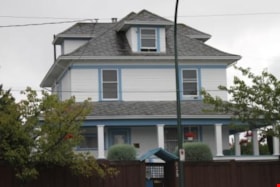
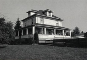
Coburn House
https://search.heritageburnaby.ca/link/landmark510
- Repository
- Burnaby Heritage Planning
- Description
- The Coburn House is a two and one-half storey plus basement Foursquare farm house. Prominently situated on a rise of land along the east side of Boundary Road overlooking Kingsway, it stands among single-family houses later constructed on its subdivided farm land.
- Associated Dates
- 1910
- Formal Recognition
- Heritage Designation, Community Heritage Register
- Other Names
- Minerva Jane Coburn House
- Street View URL
- Google Maps Street View
- Repository
- Burnaby Heritage Planning
- Other Names
- Minerva Jane Coburn House
- Geographic Access
- Boundary Road
- Associated Dates
- 1910
- Formal Recognition
- Heritage Designation, Community Heritage Register
- Enactment Type
- Bylaw No. 9184
- Enactment Date
- 08/05/1989
- Description
- The Coburn House is a two and one-half storey plus basement Foursquare farm house. Prominently situated on a rise of land along the east side of Boundary Road overlooking Kingsway, it stands among single-family houses later constructed on its subdivided farm land.
- Heritage Value
- The Coburn House is important as a surviving representation of Burnaby’s early settlement period, when the municipality was largely an agricultural and residential suburb. It was built in 1910 by carpenter William Kirkham for Minerva Jane Coburn (1868-1940), and three years later the builder and client were married. Together, they operated the Surprise Poultry Farm, and were frequent participants at the local Central Park Farmers' Institute Exhibitions. This house is valued as an excellent and well-preserved example of a substantial Edwardian era Foursquare farm house. Significant due to its generous size, dominant symmetry, the prominent verandah that wraps around the front and both sides, and the three roof dormers, this house retains a high degree of original material and integrity. The elevated siting of the house, its tall proportions and symmetrical appearance combined with its fine condition make this an excellent example of its type.
- Defining Elements
- Key elements that define the heritage character of the Coburn House include its: - prominent location on Boundary Road, on an elevated site overlooking Vancouver - residential form, scale and massing as expressed by its cubic massing and tall, dominant roof form - Foursquare style as exemplified by its symmetry, square floor plan, pyramidal bellcast roof and three hipped dormers - Edwardian era construction details such as narrow bevelled wooden siding, broad horizontal eave band with scroll-cut eave brackets, and simple window surrounds - wraparound verandah encircling three main facades, with hipped roof, square columns and closed balustrades, connected to one storey extension at rear - projecting bay window on the main floor south facade - original double-hung 1-over-1 wooden-sash windows, some in double assembly on the ground floor - internal red brick chimney
- Historic Neighbourhood
- Central Park (Historic Neighbourhood)
- Planning Study Area
- Garden Village Area
- Function
- Primary Historic--Single Dwelling
- Primary Current--Single Dwelling
- Community
- Burnaby
- Cadastral Identifier
- 002-653-427
- Boundaries
- The Coburn House is comprised of a single residential lot located at 5170 Boundary Road, Burnaby
- Area
- 541.91
- Contributing Resource
- Building
- Ownership
- Private
- Street Address
- 5170 Boundary Road
- Street View URL
- Google Maps Street View
Images
Hans & Anna Hau Residence
https://search.heritageburnaby.ca/link/landmark588
- Repository
- Burnaby Heritage Planning
- Description
- Residential building.
- Associated Dates
- c.1935
- Street View URL
- Google Maps Street View
- Repository
- Burnaby Heritage Planning
- Geographic Access
- Canada Way
- Associated Dates
- c.1935
- Description
- Residential building.
- Heritage Value
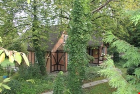
- Danish builder Hans Jorgensen Hau (1878-1944) and his wife Anna (née Sorenson, 1874-1956), constructed this highly-distinctive Tudor Revival residence circa 1935. This was a time of entrenched traditionalism, and most domestic architecture reflected period revival styles. Tudor elements have been compressed here into a cottage form, including a distinctive front façade with half timbering and brick noggin; on the sides the nogging is rock-dash stucco. Casement windows contribute to the cottage appearance. The rear façade is clad with more utilitarian shingles. A prominent brick chimney exhibits angled and corbelled brickwork. Hau worked as a bricklayer and stonemason, and this house has common elements with the Moore Residence at 5165 Sperling Avenue, which Hau designed and constructed in 1943.
- Locality
- Burnaby Lake
- Historic Neighbourhood
- Burnaby Lake (Historic Neighbourhood)
- Planning Study Area
- Morley-Buckingham Area
- Area
- 2010.52
- Contributing Resource
- Building
- Ownership
- Private
- Street Address
- 5070 Canada Way
- Street View URL
- Google Maps Street View
Images
St. Nicholas Anglican Church
https://search.heritageburnaby.ca/link/landmark641
- Repository
- Burnaby Heritage Planning
- Description
- Church building.
- Associated Dates
- 1912
- Street View URL
- Google Maps Street View
- Repository
- Burnaby Heritage Planning
- Geographic Access
- Triumph Street
- Associated Dates
- 1912
- Description
- Church building.
- Heritage Value
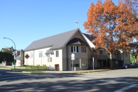
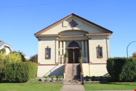
- This church was one of the first built in North Burnaby to serve the new community of Vancouver Heights. Designed by architect Frank Barrs and constructed by local builders, Arthur England and Mr. Scott, it reflected the English roots of the Anglican Church with its fine Arts and Crafts style. It was officially opened in an impressive ceremony by the Bishop of New Westminster and could accommodate 200 worshippers. It was named after Saint Nicholas, the patron saint of sailors. The adjoining parish hall was completed in 1920. The church building features a gabled roof, triangular eave brackets and a semi-octagonal apse. Stucco has been applied to the exterior, but it retains its original form, scale and massing. It now houses the Burnaby Pacific Grace Church. English-born Frank Barrs (1871-1963) arrived in Vancouver in 1907 and established an office for about one year before he began working for the Vancouver Exhibition Association. He briefly established a partnership (1912-1913) with Samuel Shewbrooks (1877-1957), and was active as an architect until about 1933.
- Locality
- Vancouver Heights
- Historic Neighbourhood
- Vancouver Heights (Historic Neighbourhood)
- Planning Study Area
- Burnaby Heights Area
- Architect
- Frank A.A. Barrs
- Area
- 1695.45
- Contributing Resource
- Building
- Ownership
- Private
- Street Address
- 3883 Triumph Street
- Street View URL
- Google Maps Street View
Images
Vancouver Heights Presbyterian Church
https://search.heritageburnaby.ca/link/landmark649
- Repository
- Burnaby Heritage Planning
- Description
- Church building.
- Associated Dates
- 1930
- Street View URL
- Google Maps Street View
- Repository
- Burnaby Heritage Planning
- Geographic Access
- Esmond Avenue
- Associated Dates
- 1930
- Description
- Church building.
- Heritage Value
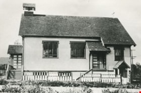
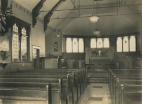
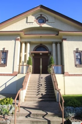
- This church replaced the first Vancouver Heights Presbyterian Church, which opened in 1911 and later became the Masonic Hall. This site was purchased in 1928, but the new church was not completed until 1930, due to the financial constraints of the Depression era. B.C. Lieutenant-Governor Bruce dedicated the church on Feb. 16, 1931. The building has retained its Classical Revival form and detailing, including its symmetrical design, columns flanking the recessed main entrance and arched windows with keystone detailing. The Vancouver Heights Presbyterian Church was designed by Australian-born architect H.H. Simmonds (1883-1954). After serving in the First World War, Simmonds resumed his local practice, and even during the Depression, his output remained prolific. In the 1920s and 30s, Simmonds was commissioned by the City of Vancouver to replace several pavilions at the Pacific National Exhibition with a consistent grouping of Art Deco buildings including the surviving Livestock Building (1929), Women and Fine Arts Building (1931) and Forum (1933).
- Locality
- Vancouver Heights
- Historic Neighbourhood
- Vancouver Heights (Historic Neighbourhood)
- Planning Study Area
- Burnaby Heights Area
- Architect
- H.H. Simmonds
- Area
- 566.79
- Contributing Resource
- Building
- Ownership
- Private
- Street Address
- 140 Esmond Avenue
- Street View URL
- Google Maps Street View
Images
Woodward House
https://search.heritageburnaby.ca/link/landmark500
- Repository
- Burnaby Heritage Planning
- Description
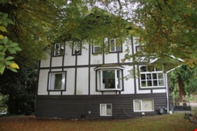
- The Woodward House is a two-storey plus basement, wood-framed house with British Arts and Crafts influences. It is set in a wooded landscape on a lakefront property, on Sperling Avenue within the Deer Lake Park Heritage Precinct of Burnaby, with expansive views of the lake.
- Associated Dates
- 1912
- Formal Recognition
- Community Heritage Register
- Other Names
- Maud & Harriet Woodward Residence
- Street View URL
- Google Maps Street View
- Repository
- Burnaby Heritage Planning
- Other Names
- Maud & Harriet Woodward Residence
- Geographic Access
- Sperling Avenue
- Associated Dates
- 1912
- Formal Recognition
- Community Heritage Register
- Enactment Type
- Council Resolution
- Enactment Date
- 26/05/2003
- Description
- The Woodward House is a two-storey plus basement, wood-framed house with British Arts and Crafts influences. It is set in a wooded landscape on a lakefront property, on Sperling Avenue within the Deer Lake Park Heritage Precinct of Burnaby, with expansive views of the lake.
- Heritage Value
- Maud Sarah Woodward (1865-1958), a pioneer nurse originally from England, and her sister Harriet Julia Woodward (1879-1969), one of Burnaby’s first teachers, had this large house built in 1912 to replace the smaller cottage they owned nearby at 5141 Sperling Avenue. Farmer, builder and longtime Deer Lake resident, Bernard R. Hill (1858-1939), was hired as the contractor. The Woodward House played an important role in the Deer Lake community. The Woodward sisters were tireless community organizers and volunteers. This house served a number of functions, and in addition to being the sisters’ home was the local post office until 1949 and also a private kindergarten/school until 1935. Originally designed in the British Arts and Crafts style with a simple rustic exterior of cedar shingles, it is an excellent example of the type of residence constructed by middle-class citizens in the Deer Lake neighbourhood. The B.C. Electric Railway's Burnaby Lake Interurban line, which opened June 12, 1911, fostered the development of Deer Lake as well as other Edwardian era neighbourhoods in Burnaby.
- Defining Elements
- Key elements that define the heritage character of the Woodward House include its: - lakefront location, within the Deer Lake Park Heritage Precinct - residential form, scale and massing as exhibited by its two-storey height, full basement, square floor plan and side-gabled roof - internal red-brick chimneys - British Arts and Crafts features such as cedar shingle siding, extant under later plywood - associated landscape features such as mature coniferous trees
- Historic Neighbourhood
- Burnaby Lake (Historic Neighbourhood)
- Planning Study Area
- Morley-Buckingham Area
- Builder
- Bernard R. Hill
- Function
- Primary Historic--Single Dwelling
- Primary Current--Single Dwelling
- Community
- Deer Lake
- Cadastral Identifier
- P.I.D.002-507-064
- Boundaries
- The Woodward House is comprised of a single residential lot located at 5195 Sperling Avenue, Burnaby.
- Area
- 1788.5
- Contributing Resource
- Building
- Ownership
- Public (local)
- Documentation
- City of Burnaby Planning and Building Department, Heritage Site Files
- Street Address
- 5195 Sperling Avenue
- Street View URL
- Google Maps Street View
