Narrow Results By
Creator
- Associated Factory Mutual Fire Insurance Cos 1
- Burnett, Geoffrey K. 1
- Burnett & McGugan, Engineers and Surveyors 15
- City of Burnaby 2
- Draper, William Nelson 1
- Garden, Hermon & Burwell 1
- Gauvreau, Narcisse B. 1
- Government of Canada - Department of Mines - Geological Survey Branch 1
- Hill, Albert James 15
- Hill & Burnett 2
- Schwabb, C.L. Jr. 1
- Smith, H. Neville 2
Person / Organization
- Air Raid Precautions (A.R.P.) 1
- All Saints Anglican Church 1
- BC Society of Model Engineers (BCSME) 1
- British Columbia Provincial Police 1
- Broadview Presbyterian Church 1
- Burnaby Village Museum 4
- Century Park Museum Association 1
- Chinese Market Gardens 1
- Cutress, Harry Charles 1
- C.W. Parker Company 1
- Descoteau, Norah Irene Byrne 7
- Dominion Bridge Company 1
Engineering Department fonds
https://search.heritageburnaby.ca/link/archivedescription43
- Repository
- City of Burnaby Archives
- Date
- 1912-2014
- Collection/Fonds
- Engineering Department fonds
- Description Level
- Fonds
- Physical Description
- 1m of textual records, approximately 2000 cartographic and architecural drawings
- Scope and Content
- Fonds consists of records created by the Engineering department including environmental service files, physical plant plans, and administrative records.
- Repository
- City of Burnaby Archives
- Date
- 1912-2014
- Collection/Fonds
- Engineering Department fonds
- Physical Description
- 1m of textual records, approximately 2000 cartographic and architecural drawings
- Description Level
- Fonds
- Access Restriction
- Subject to FOIPPA
- Reproduction Restriction
- Reproductions subject to FOIPPA
- Scope and Content
- Fonds consists of records created by the Engineering department including environmental service files, physical plant plans, and administrative records.
- History
- In 2020, responsibility for environmental management transferred to Climate Action and Energy, with Engineering retaining responsibility for geotechnical investigations and graffiti management. In 2022, Engineering became responsible for a consolidated Transportation group that aligns transportation planning and implementation functions. Green Fleet and Equipment also moved from Climate Action and Energy to the Public Works division of the Engineering Department. In 2022, Facilities Management was transferred from Engineering to the newly-created Lands and Facilities Department. James Lota served as General Manager, Engineering from 2021-2022. Jozsef Dioszeghy has served in the role since April 2022.
- Creator
- City of Burnaby
- Notes
- Title based on contents of fonds.
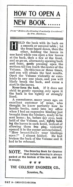
leaflet
https://search.heritageburnaby.ca/link/museumartifact28716
- Repository
- Burnaby Village Museum
- Accession Code
- HV973.38.14
- Description
- How To Open A New Book - Leaflet. From 'Modern Bookbinding Practically Considered', By Wm. Matthews.". Provides detailed instructions on how to properly open a book. The leaflet is produced by The Colliery Engineering Co. in Scranton Pa.
- Maker
- Colliery Engineering Co
- Country Made
- United States of America
- Province Made
- Pennsylvania
- Site/City Made
- Scranton
Images

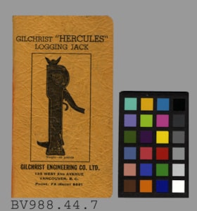
notebook
https://search.heritageburnaby.ca/link/museumartifact4113
- Repository
- Burnaby Village Museum
- Accession Code
- BV988.44.7
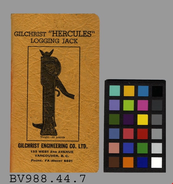
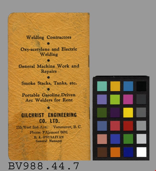
- Description
- Hercules Logging Jack - Notebook -- [1941]. Notebook produced by Gilchrist Engineering Company Limited on 135 West 2nd Avenue, Vancouver B.C. The front cover of the notebook advertises the Gilchrist "Hercules" Logging Jack, with an illustration of the jack. Inside the notebook is a price list for repair parts as of June 1st 1941. The back of the cover advertises the other services that Gilchrist Engineering provides. The notebook measures 8cm x 14.5cm.
- Subjects
- Documentary Artifacts
- Advertising Medium
Images
Dease Lake survey map
https://search.heritageburnaby.ca/link/archivedescription64449
- Repository
- City of Burnaby Archives
- Date
- April 12, 1944
- Collection/Fonds
- Burnaby Historical Society fonds
- Description Level
- Item
- Physical Description
- 1 map
- Scope and Content
- Item is a Dease Lake survey map produced by the Canada Department of Mines and Resources, Surveys and Engineering Branch.
- Repository
- City of Burnaby Archives
- Date
- April 12, 1944
- Collection/Fonds
- Burnaby Historical Society fonds
- Subseries
- Bancroft family subseries
- Physical Description
- 1 map
- Description Level
- Item
- Record No.
- MSS110-037
- Accession Number
- BHS2004-06
- Scope and Content
- Item is a Dease Lake survey map produced by the Canada Department of Mines and Resources, Surveys and Engineering Branch.
- Media Type
- Cartographic Material
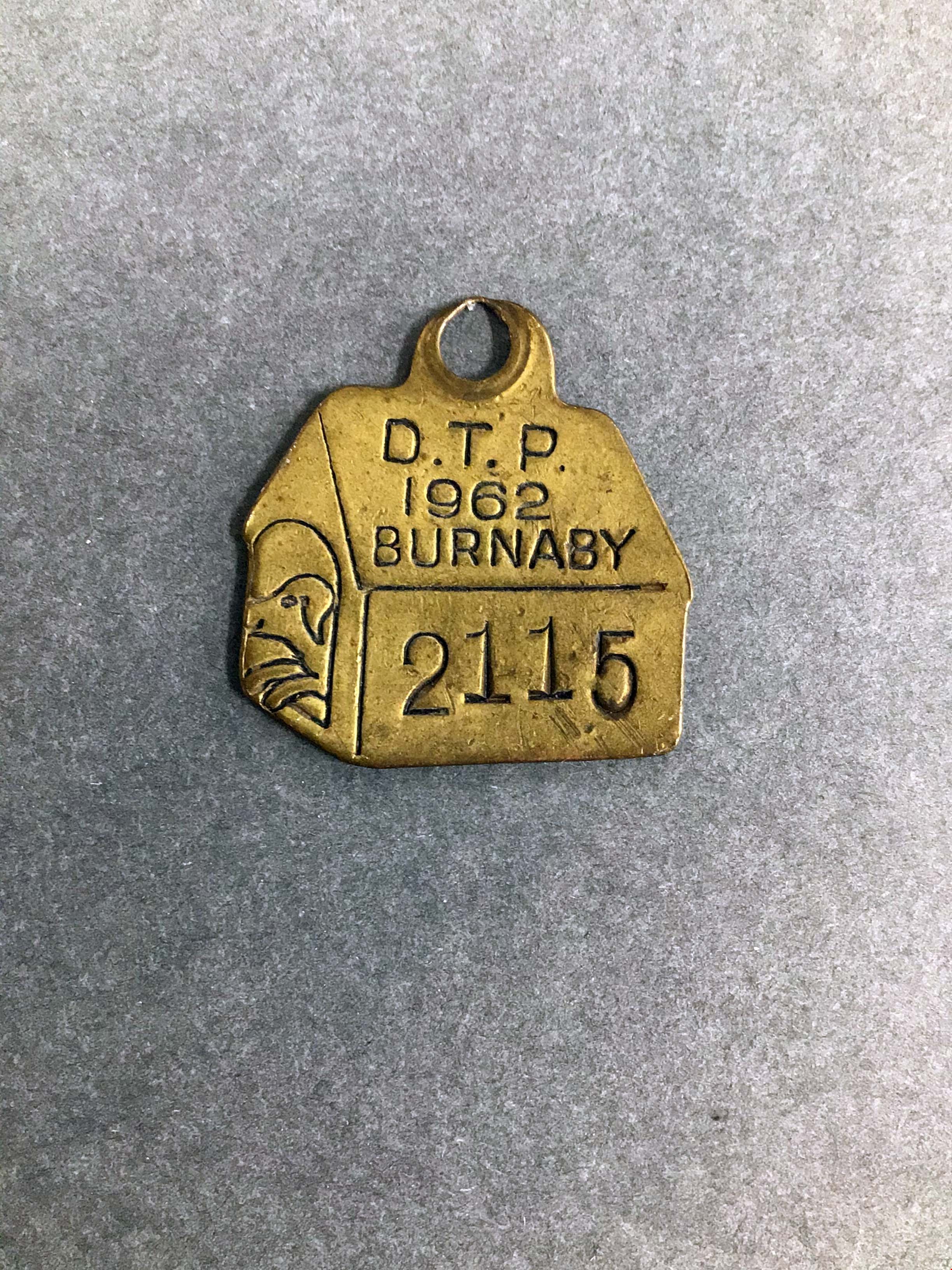
dog tag
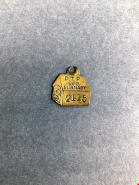
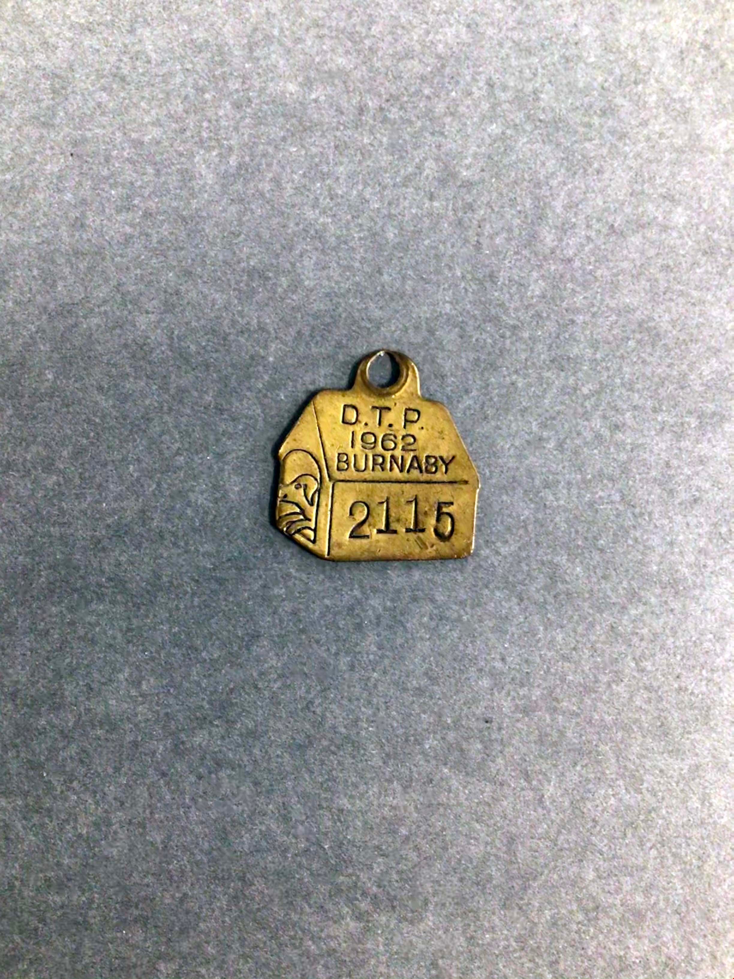
https://search.heritageburnaby.ca/link/museumartifact91530
- Repository
- Burnaby Village Museum
- Accession Code
- BV022.5.1
- Description
- A small dog tag in the shape of a cartoon dog house. There is a sketch of a cartoon dog sitting in the entrance of the house, and the tag details are etched into the "roof" and "side" of the dog house.
- Object History
- The owner of the dog who wore this tag is Bernice Bell (nee Cashato) who lived in Burnaby with her parents. Her father, Joe Cashato, worked for the Engineering department of the City of Burnaby.
- Category
- 08. Communication Artifacts
- Classification
- Documentary Artifacts - - Other Documents
- Object Term
- Animal License
- Marks/Labels
- The label etched into the tag reads: "D.T.P 1962 Burnaby" followed by the number 2115
- Colour
- Bronze
- Measurements
- height: 3.5 cm width: 3.2 cm
- Historic Neighbourhood
- Capitol Hill (Historic Neighbourhood)
- Planning Study Area
- Capitol Hill Area
Images
Dominion Bridge Company Limited - Burnaby Plant
https://search.heritageburnaby.ca/link/museumdescription17538
- Repository
- Burnaby Village Museum
- Date
- 29 Aug. 1957
- Collection/Fonds
- Burnaby Village Museum Map collection
- Description Level
- Item
- Physical Description
- 1 plan : col. lithographic print ; 50.5 x 84 cm
- Scope and Content
- Item consists of a fire insurance plan of the Dominion Bridge Company Burnaby Plant located on the east side of Boundary Road near Lougheed Highway. The plan is in two sheets mounted on a backing board. The buildings are located and colour coded. The plan includes profiles of the buildings. Title o…
- Repository
- Burnaby Village Museum
- Collection/Fonds
- Burnaby Village Museum Map collection
- Description Level
- Item
- Physical Description
- 1 plan : col. lithographic print ; 50.5 x 84 cm
- Material Details
- Scale [1:960]
- Scope and Content
- Item consists of a fire insurance plan of the Dominion Bridge Company Burnaby Plant located on the east side of Boundary Road near Lougheed Highway. The plan is in two sheets mounted on a backing board. The buildings are located and colour coded. The plan includes profiles of the buildings. Title on plan reads "DOMINION BRIDGE COMPANY, LIMITED / "BURNABY PLANT" / Burnaby, B.C.". The site plan was surveyed by C. L. Schwaab Jr.
- History
- Dominion Bridge Company was a major enterprise in Burnaby operating from the 1930 until the mid 1970s. Dominion Bridge constructed steel structures ranging from portions of the Golden Gate and Lions Gate Bridges to holding tanks for pulp mills. Beginning in the mid-1970s, unused areas of the site were used for filming on a temporary basis and in 1987 the site was established as a dedicated studio production facility named Bridge Studios.
- Creator
- Schwabb, C.L. Jr.
- Subjects
- Buildings - Industrial - Factories
- Names
- Dominion Bridge Company
- Responsibility
- Associated Factory Mutual Fire Insurance Cos
- Geographic Access
- Boundary Road
- Street Address
- 2400 Boundary Road
- Accession Code
- BV015.10.1
- Access Restriction
- Restricted access
- Reproduction Restriction
- May be restricted by third party rights
- Date
- 29 Aug. 1957
- Media Type
- Cartographic Material
- Historic Neighbourhood
- Broadview (Historic Neighbourhood)
- Planning Study Area
- West Central Valley Area
- Scan Resolution
- 400
- Scan Date
- 2021-11-28
- Notes
- Title based on contents of plan
- Scale on plan reads "1 inch = 80 ft / By V. Pitkin"
- Identfication information in bottom right corner of plan reads: "FACTORY MUTUAL ENGINEERING DIVISION / Associated Factory Mutual Fire Insurance Cos. / Norwood, Mass. / SERIAl 47330 / Replacing 35238 / INDEX 3994"
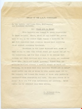
memorandum
https://search.heritageburnaby.ca/link/museumartifact39834
- Repository
- Burnaby Village Museum
- Accession Code
- BV999.17.9
- Description
- Memorandum from "Office of the A.R.P. Controller" "re: First Aid in Brief"; this was sent "to the Warden, Auxiliary Fire, Engineering and Messenger Services"; c. 1940s; authored by "J. Albuary Clou, Controller"; tyewritten in black ink; paper is yellowed
- Object History
- Item was used by Harry Charles Cutress who was an active member of the Burnaby Air Raid Precautions (A.R.P.) in South Burnaby.
- Category
- 08. Communication Artifacts
- Classification
- Documentary Artifacts - - Other Documents
- Object Term
- Serial
- Title
- First Aid Brief
- Publication Date
- [194-]
Images
![Planning Map of Chinese Market Gardens on Marine Drive, [between 1950 and 1959] (date of original), 2017 (date of duplication) thumbnail](/media/hpo/_Data/_BVM_Images/2017/2017_0040_0002_001.jpg?width=280)
Planning Map of Chinese Market Gardens on Marine Drive
https://search.heritageburnaby.ca/link/museumdescription4297
- Repository
- Burnaby Village Museum
- Date
- [between 1950 and 1959] (date of original), 2017 (date of duplication)
- Collection/Fonds
- Herbert Yee Law family fonds
- Description Level
- Item
- Physical Description
- 1 photograph (tiff) : col. ; 300 dpi
- Scope and Content
- Scanned copy of a survey plan of district lots 163, 162, 157, 158, and 165, near the Chinese Market Gardens along Marine Drive.
- Repository
- Burnaby Village Museum
- Collection/Fonds
- Herbert Yee Law family fonds
- Description Level
- Item
- Physical Description
- 1 photograph (tiff) : col. ; 300 dpi
- Scope and Content
- Scanned copy of a survey plan of district lots 163, 162, 157, 158, and 165, near the Chinese Market Gardens along Marine Drive.
- History
- Survey plan of district lots 163, 162, 157, 158, and 165, which is primarily the area farmed by Chinese and Chinese-Canadian market gardeners around Marine Drive between Royal Oak and Mandeville (present-day Nelson). Two Chinese/Chinese Canadian land owners can be seen on the map: N.G. Wah Sing (or Ng Wah Sing) and Yee Law (or Herbert Law).
- Geographic Access
- Marine Drive
- Accession Code
- BV017.40.2
- Access Restriction
- No restrictions
- Reproduction Restriction
- No known restrictions
- Date
- [between 1950 and 1959] (date of original), 2017 (date of duplication)
- Media Type
- Cartographic Material
- Historic Neighbourhood
- Fraser Arm (Historic Neighbourhood)
- Planning Study Area
- Big Bend Area
- Scan Resolution
- 300
- Scan Date
- 11/19/2017
- Scale
- 100
- Notes
- Title based on contents of copy scan of map
- Herbert Yee Law was donor's father and this map may have originally been his copy of the city planning/engineering documents.
Images
![Planning Map of Chinese Market Gardens on Marine Drive, [between 1950 and 1959] (date of original), 2017 (date of duplication) thumbnail](/media/hpo/_Data/_BVM_Images/2017/2017_0040_0002_001.jpg)

Plan of Subdivision of Lot 14 of North part of NW 1/4 of D.L. 150 GR.1 N.W.D
https://search.heritageburnaby.ca/link/museumdescription11117
- Repository
- Burnaby Village Museum
- Date
- 1912
- Collection/Fonds
- Ronald G. Scobbie collection
- Description Level
- Item
- Physical Description
- 2 plans : ink on linen + blueprint ; 21.5 x 27.5 cm
- Scope and Content
- File consists of "Plan of Subdivision of Lot 14 of North / Part of N.W. 1/4 of D.L. 150, GR.1. / N.W.D." and blueprint of same.
- Repository
- Burnaby Village Museum
- Collection/Fonds
- Ronald G. Scobbie collection
- Description Level
- Item
- Physical Description
- 2 plans : ink on linen + blueprint ; 21.5 x 27.5 cm
- Material Details
- Scale [1:1200]
- Scope and Content
- File consists of "Plan of Subdivision of Lot 14 of North / Part of N.W. 1/4 of D.L. 150, GR.1. / N.W.D." and blueprint of same.
- Creator
- Hill & Burnett
- Geographic Access
- Jubilee Avenue
- Accession Code
- HV984.57.10
- Access Restriction
- No restrictions
- Reproduction Restriction
- No known restrictions
- Date
- 1912
- Media Type
- Cartographic Material
- Planning Study Area
- Suncrest Area
- Scan Resolution
- 600
- Scan Date
- 2-Oct-19
- Scale
- 100
- Notes
- Transcribed title
- Notes in red crayon on verso of both plans read: "00079"
- Oval shaped stamp in blue ink on front of blueprint plan reads: "Corporation of Burnaby / Feb. 2 1912 / Engineering Department"
- Stamp in red ink on verso of Blueprint plan reads: "Hill & Burnett / Civil Engineers / B.C. Land Surveyors / New Westminster B.C."
- Handwritten note on front of blueprint plan reads: "T... [sic] approved / subject to 20' Laws [sic] / being given. / Fred L. Macpherson / Engineer / Feb. 6th 1912"
Images


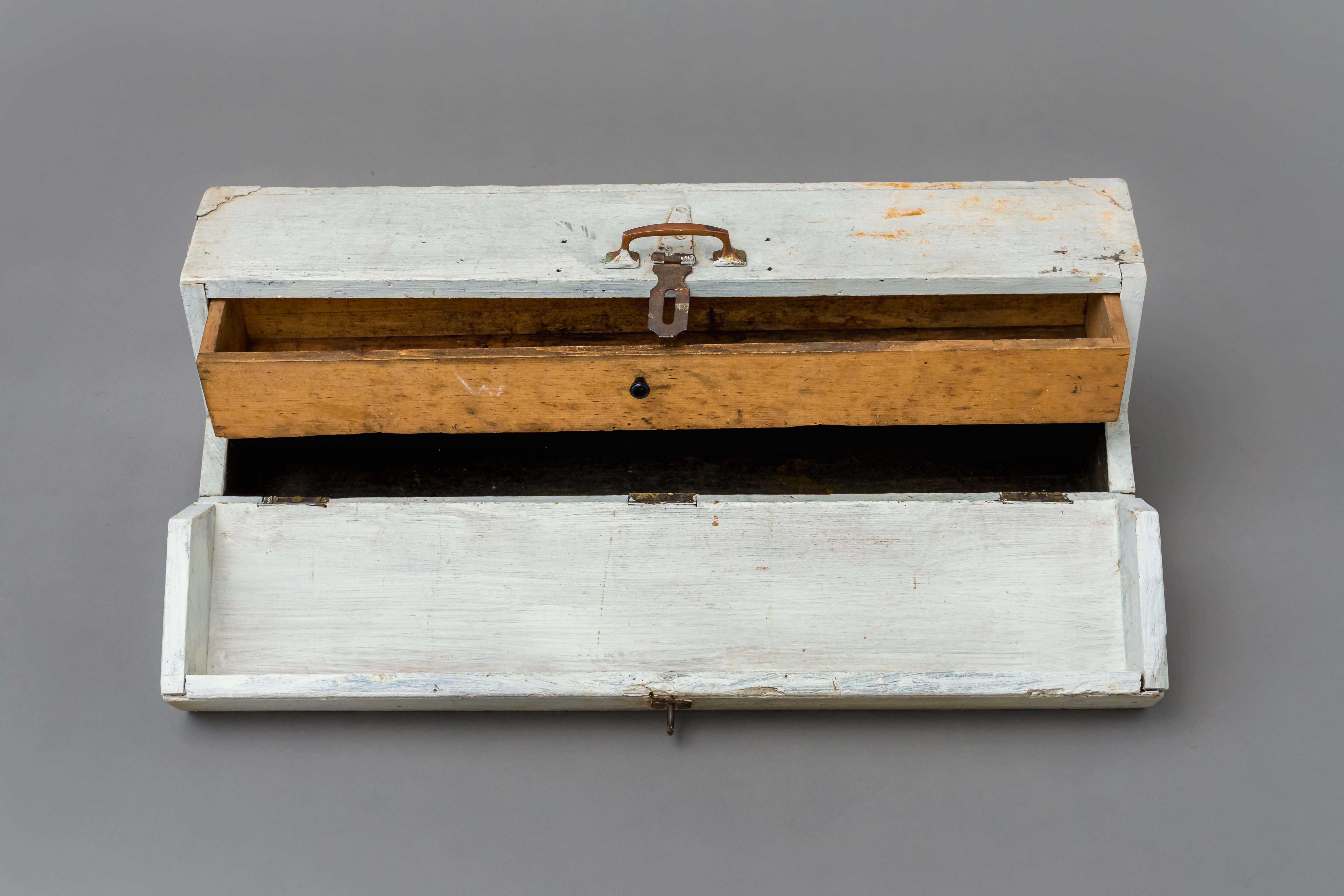
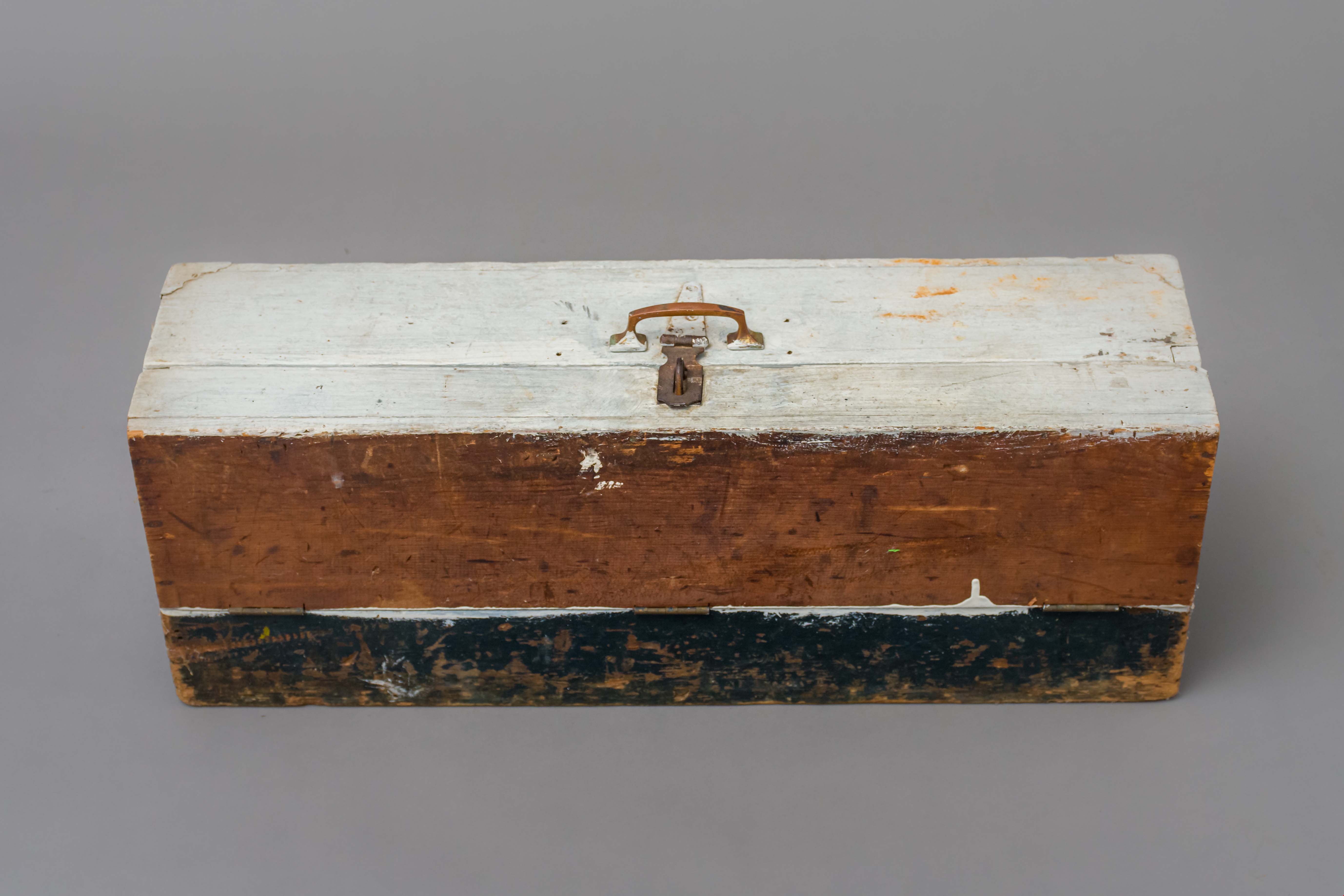
Toolbox
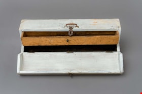
https://search.heritageburnaby.ca/link/museumartifact89169
- Repository
- Burnaby Village Museum
- Accession Code
- BV018.23.2
- Description
- toolbox; hand-made toolbox with pull-out interior drawer; wood with 3/4 fold-down lid, metal carry handle and lock hasp; steel hinges and two metal corners at top of box; white and black paint; unpainted wood interior drawer with small pull handle.
- Object History
- This tool box was made by donor's father David, who worked as a machinest at Heaps Engineering in New Westminster. David was born in Scotland in 1882 and immigrated to Canada. He lived in Spruce Street and Telford Street in Burnaby. His children atteneded Kingsway West Elementary School, South Burnaby and King Edward High School.
- Category
- 04.Tools & Equipment for Materials
- Classification
- Multiple Use T&E for Materials
- Object Term
- Container, Tool
- Measurements
- L: 71.2 cm W: 20.0 H: 25.0 cm
- Historic Neighbourhood
- Central Park (Historic Neighbourhood)
- Planning Study Area
- Maywood Area
Images
![Survey and Subdivision plans in New Westminster District Group 1 – Burnaby
, [1861]-[1910] thumbnail](/media/hpo/_Data/_BVM_Cartographic_Material/1977/1977_0093_0019a_001.jpg?width=280)
Survey and Subdivision plans in New Westminster District Group 1 – Burnaby
https://search.heritageburnaby.ca/link/museumdescription6988
- Repository
- Burnaby Village Museum
- Date
- [1861]-[1910]
- Collection/Fonds
- Burnaby Village Museum Map collection
- Description Level
- File
- Physical Description
- 14 plans : 3 plans : black ink on paper hand col. + 7 plans : black ink on paper + 4 plans : graphite on paper mounted on 2 sides of cardboard 76 x 102 cm
- Scope and Content
- Item consists of a large board of four New Westminster District Gp 1 - subdivision plans mounted on one side and ten New Westminster District Gp 1 - subdivision plans mounted on the other side. Side A: 1. "Plan /of / Lots 166A, 166 and 167 /, Gr.1, N.W.D. / Showing Misconstructed Roads in Gree…
- Repository
- Burnaby Village Museum
- Collection/Fonds
- Burnaby Village Museum Map collection
- Description Level
- File
- Physical Description
- 14 plans : 3 plans : black ink on paper hand col. + 7 plans : black ink on paper + 4 plans : graphite on paper mounted on 2 sides of cardboard 76 x 102 cm
- Material Details
- Scales [between 1:2376 and 1:7920]
- Index number on edge of board reads: "19"
- Scope and Content
- Item consists of a large board of four New Westminster District Gp 1 - subdivision plans mounted on one side and ten New Westminster District Gp 1 - subdivision plans mounted on the other side. Side A: 1. "Plan /of / Lots 166A, 166 and 167 /, Gr.1, N.W.D. / Showing Misconstructed Roads in Green / 5 chs = 1 in.". (plan is drawn in black ink and hand coloured in red, green and orange ink). A section in the centre of the plan is coloured in red ink and identified as "C.S. Richmond" running from the North Arm of Fraser River to Wiggins Road and divided by "New Wiggins Rd. (as gazetted)" (coloured in orange ink) and two"Constructed Road(s)" (coloured in green ink). Plan is initialed by: "RB" [sic] (in blue pencil crayon) 2. Plan of / Subdivision of / Lot 166 / Group One / New Westminster District / Scale 4 chs = 1 in. / Map No 524". Plan is drawn in graphite and signed by "Surrig [sic] Welhams [sic] / P.L.S." Plan is initialed by: "RB" [sic] (in blue pencil crayon) 3. Plan of "Survey / of Highway / For / Burnaby Council / in / Lots 13 _14 / Group One / Scale 4 chs = 1 in." Signed by "Albert J. Hill, P.L.S." Caribou Street and Caribou Road run through the centre of the plan. Plan is stamped: "Albert J. Hill, Civil Engineer / and / Provincial Land Surveyor, / New Westminster, / B.C.". Plan is initialed by: "RB" [sic] (in blue pencil crayon) 4. A Plan of Lots 166A, 166 and 167, Group One, New Westminster District (drawn in graphite). A section in the centre of the plan is identified as "C.S. Richmond" running from the North Arm of Fraser River and divided by "New Wiggins Rd. (as gazetted)" and two "Constructed Road(s)". Plan is initialed by: "RB" [sic] (in blue pencil crayon) Side B: 1. Small plan drawn in black ink (no title) identifying lots north of the "North Arm" of the Fraser River. Lots identified include: Lot 99, Lot 98, Lot 157, Lot 158, Lot 163, Lot 162, Lot 159, Lot 163, Lot 162, Lot 165, Lot 166A, Lot 155B, Lot 155A and Lot 159. "Scale 40 chains to one inch" . Plan is initialed by: "RB" [sic] (in blue pencil crayon) (Geographic location: Burnaby) 2. Small plan drawn in black ink (no title) identifying lots north of the North Arm of the Fraser River as "Lots 155, 155A, 155B, 155C, 162, 163, 164, 165, 166A and 167". Plan is initialed by: "RB" [sic] (in blue pencil crayon) (Geographic location: Burnaby) 3. Small plan drawn in black ink (no title) which identifies "Lot 151 / Reserve/ for / Race Course"; "Reserve / 64 A / L. 152 G.1"; and other Lots: 32, 33, 34, 35, 36, 38, 39. The plan is signed "Surveyor G.Turn [sic] July / 61 / from Vol 40 R.L. notes [sic]" Plan is stamped: "Albert J. Hill, Civil Engineer / and / Provincial Land Surveyor, / New Westminster, / B.C." Plan is initialed by: "RB" [sic] (in blue pencil crayon) (Geographic location: Burnaby) 4. Small plan drawn in black in with faded red colouring on centre lot identified as "Lot 34" running north from "Vancouver Road" . Plan is stamped: "Albert J. Hill, Civil Engineer / and / Provincial Land Surveyor, / New Westminster, / B.C." Plan is initialed by: "RB" [sic] (in blue pencil crayon) (Geographic location: Burnaby) 5. Plan drawn in graphite and identified as "Lot 98, Gr.1," along with the intials "RB" [sic] (both are handwritten in blue crayon pencil on top of plan) The B.C.E.Railway is identified running through the plan along with Jubilee Road and Royal Oak Road. The plan is signed with the name "Wm. Murray" and the Plan is stamped: "Albert J. Hill, Civil Engineer / and / Provincial Land Surveyor, / New Westminster, / B.C.". (Geographic location: Burnaby) 6. Plan drawn in graphite identified as "Port Lot 13, Gr.1" along with the intials "RB" [sic] (both are handwritten in blue crayon pencil on top of plan) Plan is stamped: "Albert J. Hill, Civil Engineer / and / Provincial Land Surveyor, / New Westminster, / B.C.". (Geographic location: Burnaby) 7.Plan drawn in black ink and identified as "Lot 98 G.1" along with the intials "RB" [sic] (both are handwritten in blue crayon pencil on top of plan). A "Road Reservation" is identified running north between "Electric Tramway" and connecting with "Royal Oak Road". Plan is stamped: "Albert J. Hill, Civil Engineer / and / Provincial Land Surveyor, / New Westminster, / B.C." (Geographic location: Burnaby) 8. Plan drawn in black ink and divided into two sections, the upper plan is identified as "Portion / Lots 100 / area / 101, Gr.1" and the lower plan is identified as "Portion L. 3 G. 1" along with the intials "RB" [sic] (these identifiers are handwritten in blue crayon pencil on top of the plan). Portions of Lot 100 and Lot 101 are each divided into 6 sections and the Portion of Lot 3 plan is divided into 24 sections. The plan includes a note in black ink that reads: " Received from Wm Fromme [sic] / from Wm. Trapp / Nov. 28, 1895 / A. J. T...[sic]". (Geographic location: Burnaby) 9. Plan drawn in black ink (no title) identifying soil, buildings and geographic features in southern Burnaby. The plan is bordered by "New Westminster City" (Tenth Avenue and DL 172) to the south east and DL 173 to the south, DL 158 to the west and the B.C.E. Tramway to the north. Plan includes District Lots: 155A, 158, 159, 171, 160, 53 and 95 and identifies soil, marshland and ravines throughout. Plan identifies the following features: a "Team Road" running through Lots 158 and 159 along with "Fair Orchard Soil / Even Surface Throughout / No Ravines", "Gravel and Shingle" (bottom of Lot 158), "North Arm Road" crossing "Byrne Road" and connecting with "Power House Road" which runs north to connect with "Highland Park Station" and the B.C.E. Tramway, "Power Ho" in the northeast corner of DL 160, a "Brook" connected with a "Deep Ravine" running between DL 53, DL 95 and DL 160 along with "Good Soil" and "Fair Orchard Soil" identified nearby in DL 95. Scale is identified as "10 chs = 1 in." Plan is stamped: "Albert J. Hill, Civil Engineer / and / Provincial Land Surveyor, / New Westminster, / B.C." Plan is initialed by: "RB" [sic] (in blue pencil crayon) (Geographic location: Burnaby) 10. Plan drawn in black ink (no title) with Burnaby Lake and Deer Lake at the centre. The plan is bordered by the following District Lots identified as: 117, 118 and 68 to the west, Lots 80, 79 and 85 to the southwest, Lots 11, 13, and 1 (City of New Westminster) to the south east, the North Road boundary to the east and Lots 8, 56, 57, 59, and 136 to the North. The lower right hand corner of the plan has a small inset which reads: "Burnaby Lake" and "Page 19 R.B. Notes". Plan is initialed by: "RB" [sic] (in blue pencil crayon) (Geographic location: Burnaby)
- Creator
- Hill, Albert James
- Accession Code
- HV977.93.19
- Access Restriction
- No restrictions
- Reproduction Restriction
- No known restrictions
- Date
- [1861]-[1910]
- Media Type
- Cartographic Material
- Scan Resolution
- 300
- Scale
- 72
- Notes
- Title based on contents of file
- Scale is measured in chains. (One chain equals 792 inches)
- The term "Lot" can also refer to a "District Lot”
- Some plans are stamped: "Albert J. Hill, Civil Engineer / and / Provincial Land Surveyor, / New Westminster, / B.C." and intialed: "RB" [sic]
Images
![Survey and Subdivision plans in New Westminster District Group 1 – Burnaby
, [1861]-[1910] thumbnail](/media/hpo/_Data/_BVM_Cartographic_Material/1977/1977_0093_0019a_001.jpg)

![Survey and Subdivision plans in New Westminster District Group 1 – Burnaby
, [1892-1908] thumbnail](/media/hpo/_Data/_BVM_Cartographic_Material/1977/1977_0093_0020a_001.jpg?width=280)
Survey and Subdivision plans in New Westminster District Group 1 – Burnaby
https://search.heritageburnaby.ca/link/museumdescription6989
- Repository
- Burnaby Village Museum
- Date
- [1892-1908]
- Collection/Fonds
- Burnaby Village Museum Map collection
- Description Level
- File
- Physical Description
- 12 plans : 6 plans : black ink on paper + 6 plans : graphite on paper mounted on 2 sides of cardboard 76 x 102 cm
- Scope and Content
- Item consists of a large board of six New Westminster District Gp 1 - subdivision plans mounted on one side and three New Westminster District Gp 1 - subdivision plans mounted on the other side. Side A: 1. Plan drawn in graphite with markings "Plan 535" "Scale 3 chs = 1 in." Plan appears to ext…
- Repository
- Burnaby Village Museum
- Collection/Fonds
- Burnaby Village Museum Map collection
- Description Level
- File
- Physical Description
- 12 plans : 6 plans : black ink on paper + 6 plans : graphite on paper mounted on 2 sides of cardboard 76 x 102 cm
- Material Details
- Scales [between 1:240 and 1:7920]
- Index number on edge of board reads: "20"
- Scope and Content
- Item consists of a large board of six New Westminster District Gp 1 - subdivision plans mounted on one side and three New Westminster District Gp 1 - subdivision plans mounted on the other side. Side A: 1. Plan drawn in graphite with markings "Plan 535" "Scale 3 chs = 1 in." Plan appears to extend onto another piece of paper with a title "Lo [sic] 506" ans "Scale 2 chs = 1 in." Plan is stamped: "Albert J. Hill, Civil Engineer / and / Provincial Land Surveyor, / New Westminster, / B.C." (Geographic location: Burnaby) 2. Plan of "Douglas Road" (written at top in blue pencil) and "Plan 642 / Reg. Apr. 8 1892 / ....Lots / 3 & 4 Bl. I...[sic]" (written in graphite). Road runs through Lots 29, 28, 30, 90 and 91. Note in red ink at bottom of plan reads: "Sketch plans as sent to Council / Aug. 28_1893 / ..." Plan is stamped: "Albert J. Hill, Civil Engineer / and / Provincial Land Surveyor, / New Westminster, / B.C." (Geographic location: Burnaby) 3. Plan drawn in graphite identified with markings "L.9 in / L. 88" "Scale 3 chs = 1 in. / Albert J. Hill / B.C.L.S. / 11/3/08" (Geographic location: Burnaby) 4. Plan in black ink identified as "No.2" / Lot 101 & 100 / Gr.1" / Lot 3 Gr. 1" (handwritten in blue pencil) with "Scale : 2 Inches = 1 Mile". Plan is stamped: "Albert J. Hill, Civil Engineer / and / Provincial Land Surveyor, / New Westminster, / B.C." (Geographic location: Burnaby) 5. Plan in black ink identified as "Sub. L. 28 and 29 of / Lot 35, G - 1" (handwritten in blue pencil) "Scale 100' = 1 in." (Geographic location: Burnaby) 6. Plan drawn in graphite with markings "Lot 165 Gr.1" (handwritten in blue pencil) "Scale 10 chs = 1 in. / Albert J. Hill / B.C.L.S." (Geographic location: Burnaby) 7. "Plan / of Subdivision / of / Subdivision of Lot 10 [sic] / of Lot 53 / Group One / New Westminster Dist. / Scale 1 chs = 1 inc." (drawn and written in graphite) Plan is stamped: "Albert J. Hill, Civil Engineer / and / Provincial Land Surveyor, / New Westminster, / B.C." (Geographic location: Burnaby) Side B: 1. "Plan / of Subdivision / of / Lots 10 and 11, / in the Subdivision / of / Lot 156 Gr.1 / New Westminster District / Scale 100' = 1 "" (drawn and written in graphite) (Geographic location: Burnaby) 2. "Plan / of Subdivision / of a Portion / of / Lot 95 / Group One / New Westminster District / Scale 3 chs = 1 in." (drawn in graphite and black ink) Plan is stamped: "Albert J. Hill, Civil Engineer / and / Provincial Land Surveyor, / New Westminster, / B.C." (Geographic location: Burnaby) 3. Plan drawn in graphite and identified as "Lot 98, Gr.1" (handwritten in blue pencil). Plan identifies a "Road Reservation", "Royal Oak Road" and "Electric Tramway" and "Lot 94" to the north of "Lot 98" (Geographic location: Burnaby) 4. Plan drawn in graphite and identified as "Lot 25, Gr.1" (handwritten in blue pencil) Lot 25 is identified as "Love" "Scale 7 chs = 1 in. / Albert J. Hill B.C.L.S." Plan is dated "24/7/07" Plan is stamped: "Albert J. Hill, Civil Engineer / and / Provincial Land Surveyor, / New Westminster, / B.C." (Geographic location: Burnaby) 5. Profile plan in black ink with marking "Douglas Road" and intials "RGS" [sic] (handwritten in blue pencil) "City Boundary / Hastings Road / Scale Hor 200' = 1" / Vert 20' = 1"" Plan is also marked in red pencil and reads: "Please / See other side". Plan is stamped: "Albert J. Hill, Civil Engineer / and / Provincial Land Surveyor, / New Westminster, / B.C." (Geographic location: Burnaby) 6. Plan of "Profile / on Tramway Track / New Vancouver Road / Scales Hor 200 ft = 1 inch / Vert 20 ft = 1 inch" (Geographic location: Burnaby)
- Creator
- Hill, Albert James
- Accession Code
- HV977.93.20
- Access Restriction
- No restrictions
- Reproduction Restriction
- No known restrictions
- Date
- [1892-1908]
- Media Type
- Cartographic Material
- Scan Resolution
- 300
- Scale
- 72
- Notes
- Title based on contents of file
- Scale is measured in chains and feet. (One chain equals 792 inches)
- The term "Lot" can also refer to a "District Lot”
Images
![Survey and Subdivision plans in New Westminster District Group 1 – Burnaby
, [1892-1908] thumbnail](/media/hpo/_Data/_BVM_Cartographic_Material/1977/1977_0093_0020a_001.jpg)

![Survey and Subdivision plans in New Westminster District Group 1 – Burnaby, [1905-1917] thumbnail](/media/hpo/_Data/_BVM_Cartographic_Material/1977/1977_0093_0022a_001.jpg?width=280)
Survey and Subdivision plans in New Westminster District Group 1 – Burnaby
https://search.heritageburnaby.ca/link/museumdescription6991
- Repository
- Burnaby Village Museum
- Date
- [1905-1917]
- Collection/Fonds
- Burnaby Village Museum Map collection
- Description Level
- File
- Physical Description
- 12 plans : 6 black ink on paper + 2 black & col. ink on paper + 4 graphite on paper
- Scope and Content
- Item consists of a large board of six New Westminster District subdivision plans mounted on one side and six New Westminster District subdivision plans mounted on the other side. Side A: 1. Plan drawn in graphite with markings in black ink "Surveyed for Mr. W. Wilson / Paterson Stat. B.C.E.R." . …
- Repository
- Burnaby Village Museum
- Collection/Fonds
- Burnaby Village Museum Map collection
- Description Level
- File
- Physical Description
- 12 plans : 6 black ink on paper + 2 black & col. ink on paper + 4 graphite on paper
- Material Details
- Scales [between 1:360 and 1:3168]
- Index number on edge of board reads: "22"
- Scope and Content
- Item consists of a large board of six New Westminster District subdivision plans mounted on one side and six New Westminster District subdivision plans mounted on the other side. Side A: 1. Plan drawn in graphite with markings in black ink "Surveyed for Mr. W. Wilson / Paterson Stat. B.C.E.R." . Plan includes subdivision of lots situated between B.C.E. Railway and Vancouver Road (Kingsway). (Geographic location: Burnaby) 2. Subdivision plan (no title) drawn in black ink with annotations in graphite. Plan covers District Lots 2, 4 and 6, west of North Road. Plan is stamped: "Albert J. Hill, Civil Engineer / and / Provincial Land Surveyor, / New Westminster, / B.C. (Geographic location: Burnaby) 3. Plan of "Portion of Municipality" with intials "RB" [sic] (handwritten in blue crayon). Plan covers the area north east of the City of New Westminster including District Lots 11, 13, 14, 12, 1 and 2. Plan is stamped: "Albert J. Hill, Civil Engineer / and / Provincial Land Surveyor, / New Westminster, / B.C. (Geographic location: Burnaby) 4."Plan / of Subdivision of / N.W.1/4 Lot 175 / Group 1 New West. Dist. / B.C. / Scale 4 chs = 1 in. " Plan is stamped: "Albert J. Hill, Civil Engineer / and / Provincial Land Surveyor, / New Westminster, / B.C. and initialed : "RB" [sic] (in blue pencil crayon) (Geographic location: Burnaby) 5. "Subdivision / of a Portion of / Lot 15 Group 1 / New Westminster Dist. / Scale 4 chs = 1 in". Plan provides numbered sudivisions - Lots 1 to 15 of District Lot 15 in red ink. (Geographic location: Burnaby) 6. Plan of "Central Park & / Vicinity" Plan includes subdivisions of District Lot 153 east of Central Park District Lot 151 and subdivision of District Lot 36 and 49 west of Boundary Road (Vancouver). Plan is stamped: "Albert J. Hill, Civil Engineer / and / Provincial Land Surveyor, / New Westminster, / B.C. and initialed : "RB" [sic] (in blue pencil crayon). (Geographic location: Burnaby) Side B: 1. Subdivision plan (no title) drawn in black ink. Plan identifies lots between Vancouver Road (Yale Road is crossed out and replaced with Vancouver Road) and B.C.E. Railway. "Scale 2 chs = 1 in" (Geographic location: Burnaby) 2. Plan of "Subdivision Lot 1 / Lot 69 Gr. 1 / Scale 30' = 1 " " Plan identifies Boundary Road, Still Creek and a Road Allowance between District Lot 118 and District Lot 69. Plan was "Surveyed for Burnaby Mun. Council / March 11th 1908 / G.K.B." (Geographic location: Burnaby) 3. Plan drawn in black ink (no title) showing a subdivision in Lot 25 with names "Newcomb", "Debeck" and "Armstrong" along with roads identified as Third Street, Cumberland Street, Armstrong Street and Cariboo [sic] Street and including Lots 27, 11 and 13.Plan is stamped: "Albert J. Hill, Civil Engineer / and / Provincial Land Surveyor, / New Westminster, / B.C. and initialed : "RB" [sic] (in blue pencil crayon). (Geographic location: Burnaby) 4. Handrawn subdivision plan in graphite titled: "Lot 13, Gr.1" with intials "RB" [sic] (handwritten in blue crayon). Plan is bordered by Armstrong Street (Lot 11, G.1), Cumberland St. (Lot 25, G.1) and Tenth Avenue (City Boundary). The plan is singed by "Albert J. Hill / P.L.S." and one of the subdivided lots is identified with the name: "W. Karrymann". (Geographic location: Burnaby) 5. Handrawn sketch in graphite titled: "Lot 88, Gr.1" with intials "RB" [sic] (handwritten in blue crayon). Plan appears to be a draft of a subdivision plan of a portion of District Lot 88 along Cumberland Road. The plan is signed: "16/7/17 _W.F. Draper [sic] / B.C.L.S." (Geographic location: Burnaby) 6. "Plan / of Subdivision / of Blocks 61, 62 and 2 / Lot 30 / Group 1 / N.W. Dist. / Scale 1ch = 1 in". Plan is intialed by: "PB" with a note: "Also see board 2 / for duplicate" (handwritten in blue crayon). (Geographic location: Burnaby)
- Creator
- Hill, Albert James
- Geographic Access
- Boundary Road
- Kingsway
- Cumberland Street
- Accession Code
- HV977.93.22
- Access Restriction
- No restrictions
- Reproduction Restriction
- No known restrictions
- Date
- [1905-1917]
- Media Type
- Cartographic Material
- Historic Neighbourhood
- Central Park (Historic Neighbourhood)
- Scan Resolution
- 300
- Scale
- 100
- Notes
- Title based on contents of file
- Scale is measured in chains and feet. (One chain equals 792 inches)
- The term "Lot" can also refer to a "District Lot”
- Some plans are stamped: "Albert J. Hill, Civil Engineer / and / Provincial Land Surveyor, / New Westminster, / B.C." and intialed: "RB" [sic]
Images
![Survey and Subdivision plans in New Westminster District Group 1 – Burnaby, [1905-1917] thumbnail](/media/hpo/_Data/_BVM_Cartographic_Material/1977/1977_0093_0022a_001.jpg)

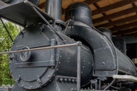
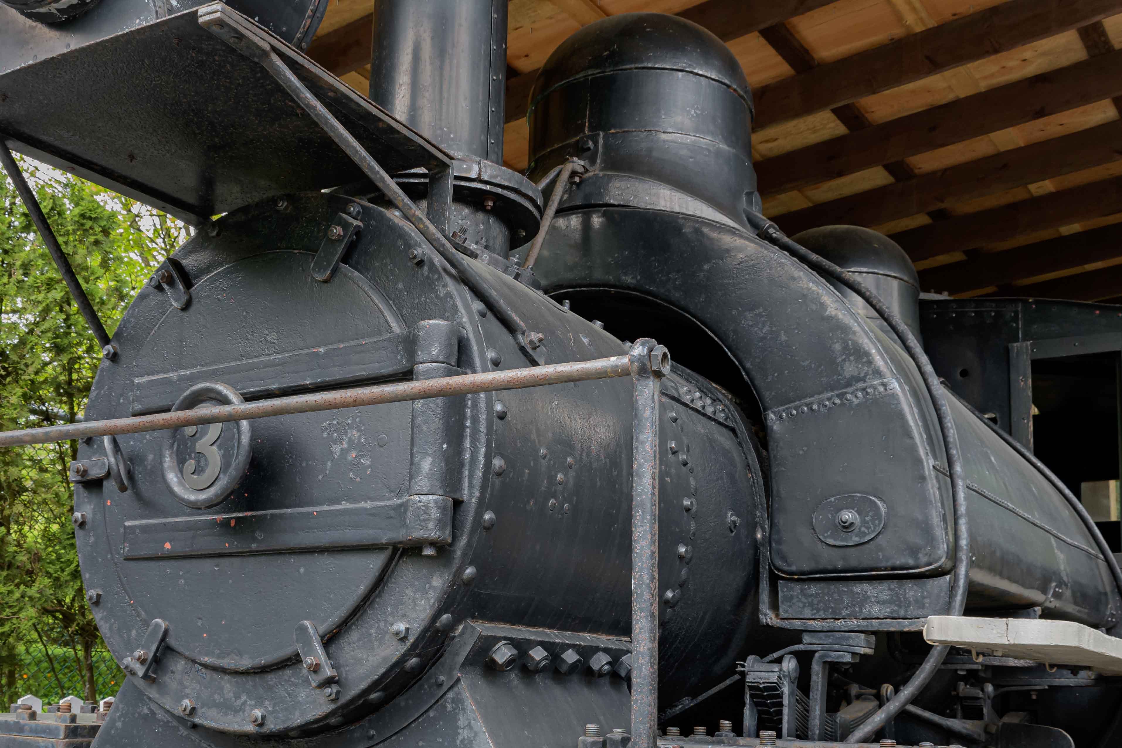
locomotive
https://search.heritageburnaby.ca/link/museumartifact6255
- Repository
- Burnaby Village Museum
- Accession Code
- BV985.16.1
- Description
- The locomotive known as, "Old Curly", is a small construction or logging engine fitted with a saddle tank for water and with two sand domes on top. The engine has a 0-4-4 wheel layout, that is no front truck, 4 driving wheels and a 4 wheel truck under the cab. There is no tender wood or coal was stacked at the rear of the cab. This engine has been altered several times in its career. There is a layer of insulation (asbestos?) between the saddle tank and the boiler. Round pane of clear "headlight glass" located at AB106-GS-6 in June 2019
- Object History
- This locomotive is also known as 'Emory'. The locomotive was nicknamed 'Curly', an expression used to describe the devil. The engine was built in San Francisco in the 1879 and was used during the building of the harbour sea wall. It was likley built by Marshutz & Cantrell. It was acquired by Andrew Onderdonk in 1881 to use during construction of the Fraser Canyon section of the Canadian Pacific Railroad (CPR). The locomotive was the first logging locomotive in this area. It was later used on the section from Savona Ferry to Kamloops. The locomotive was layed up in 1887 and not used for several years until it was purchased by the British Columbia Timber and Trading Company (BCTTC) for use on their logging railway in Surrey. In the early 1900s the engine was shifted from Surrey to the company operations north of Powell River. Its history of use is not known while it was in this area. It was brought back to Vancouver, in a damaged condition and stored on BCTTC property. It was acquired by the CPR and restored as a 50th Anniversary Project in 1930. It was displayed at the Pacific National Exhibition grounds until the 1973 when it was brought to Heritage Village (later BVM) and restored again.
- Marks/Labels
- "213D / No. 104 / T.P. 240 / W.P. 150 / T.P.T. / 1900" stamped into a smooth area above the fire door in the cab. "3" brass number riveted to the front of the boiler and painted into the side of the front lantern.
- Colour
- Black
- Measurements
- The locomotive is 26 feet 2 inches (793cm) long by 9 feet (374.3cm) wide and 12 feet (366cm) to the top of the smoke stack. The locomotive sits on 30 feet of track under a roofed shelter.
- The cab is 10 feet 3 inches (315cm) long by 7 feet 6 inches (228.6 cm) wide and 9 feet 3 inches (284.5cm) high
- Country Made
- United States of America
- Province Made
- California
- Site/City Made
- San Francisco
Images
![Survey and Subdivision plans in New Westminster District Group 1 – Burnaby
, [1900-1910] thumbnail](/media/hpo/_Data/_BVM_Cartographic_Material/1977/1977_0093_0018a_001.jpg?width=280)
Survey and Subdivision plans in New Westminster District Group 1 – Burnaby
https://search.heritageburnaby.ca/link/museumdescription6987
- Repository
- Burnaby Village Museum
- Date
- [1900-1910]
- Collection/Fonds
- Burnaby Village Museum Map collection
- Description Level
- File
- Physical Description
- 9 plans : 1 plan : blueprint ink on paper + 6 plans : black ink on paper + 2 plans : graphite on paper mounted on 2 sides of cardboard 76 x 102 cm
- Scope and Content
- Item consists of a large board of five New Westminster District Gp 1 - subdivision plans mounted on one side and four New Westminster District Gp 1 - subdivision plans mounted on the other side. Side A: 1. "Plan / of Subdivision of / a Portion / of / Lot 13, Gr.1 / New Westminster District / Scal…
- Repository
- Burnaby Village Museum
- Collection/Fonds
- Burnaby Village Museum Map collection
- Description Level
- File
- Physical Description
- 9 plans : 1 plan : blueprint ink on paper + 6 plans : black ink on paper + 2 plans : graphite on paper mounted on 2 sides of cardboard 76 x 102 cm
- Material Details
- Scales [between 1:1200 and 1:7920]
- Index number on edge of board reads: "18"
- Scope and Content
- Item consists of a large board of five New Westminster District Gp 1 - subdivision plans mounted on one side and four New Westminster District Gp 1 - subdivision plans mounted on the other side. Side A: 1. "Plan / of Subdivision of / a Portion / of / Lot 13, Gr.1 / New Westminster District / Scale - 2 chs = 1 in." Plan is bordered by Armstrong Street and Cariboo Street with Lillooet Street running through the centre. (Geographic location: Burnaby) 2. Plan of "Lot 98, Gr.1" (handwritten in blue pencil). Plan identifies lots running south of "Vancouver Road (later became Kingsway in 1912) and Royal Oak Road running north - south. Plan is stamped with: "Albert J. Hill, Civil Engineer". (Geographic location: Burnaby) 3. Plan of "Lot 85, Gr.1" (handwritten in blue pencil). "Scale 10 chs = 1 in. / Albert J. Hill / B.C.L.S." Plan is bordered by Deer Lake and Lot 84, Hastings Road, Haszard Road and idenfities Pole Line Road running through the centre. (Geographic location: Burnaby) 4. "Plan / of / Subdivision Lot 'G' / in the Subdivision of / Lot 96, Gr.1 / New Westminster District / Scale 100 ' = 1 in." The subdivision plan is bordered by False Creek Road and Westminster & Vancouver Tramway. 5. Plan (drawn in pencil) "Mr. Madill, Mar. 29/09" of "Lot 90 , G.1" / "Scale 200 ' = 1 " / Albert J. Hill, B.C.L.S." Plan is bordered by Lot 87 and Lot 91 and Hastings Road. (Geographic location: Burnaby) Side B: 1. Plan of "Extension / of the Gunn Rd. / Through / Lots 40, 42, 43 and 44, / Group One / Scale 300' = 1"" . Plan is stamped with: "Albert J. Hill, Civil Engineer / and / Provincial Land Surveyor, / New Westminster, / B.C." Road is identified running from Bainbridge Road and Vancouver Westminster Railway through Lot 44 to Lot 10. (Geographic location: Burnaby) 2. Blueprint Plan of "Lot 98, G.1" (handwritten in blue pencil) The plan identifies the Westminster & Vancouver Tramway Line, and is bordered by Lot 158 and Lot 99. Plan is stamped with: "Albert J. Hill, Civil Engineer / and / Provincial Land Surveyor, / New Westminster, / B.C." (Geographic location: Burnaby) 3. Plan, graphite on paper titled: "Lot 28, Gr.1," (handwritten in blue pencil) and titled "Cliff's Survey" with "Scale 2 chs = 1 in." Plan is bordered by Tramway, Sixth Street and Fourth Street. "Plan is stamped with: "Albert J. Hill, Civil Engineer / and / Provincial Land Surveyor, / New Westminster, / B.C." (Geographic location: Burnaby) 4. "Plan / of Subdivision / of / Subdivision Block XIII, / Lot 27, / Group One / New Westminster Dist." Scale 2 chs = 1 in. " Plan is bordered by Second Street to the east and Fourth Street to the west. Plan is stamped: "Albert J. Hill, Civil Engineer / and / Provincial Land Surveyor, / New Westminster, / B.C." (Geographic location: Burnaby)
- Creator
- Hill, Albert James
- Accession Code
- HV977.93.18
- Access Restriction
- No restrictions
- Reproduction Restriction
- No known restrictions
- Date
- [1900-1910]
- Media Type
- Cartographic Material
- Scan Resolution
- 300
- Scale
- 72
- Notes
- Title based on contents of file
- Scale is measured in chains and feet. (One chain equals 792 inches)
- The term "Lot" can also refer to a "District Lot”
Images
![Survey and Subdivision plans in New Westminster District Group 1 – Burnaby
, [1900-1910] thumbnail](/media/hpo/_Data/_BVM_Cartographic_Material/1977/1977_0093_0018a_001.jpg)

![Survey and Subdivision plans in New Westminster District Group 1 – Burnaby
, [1905-1912] thumbnail](/media/hpo/_Data/_BVM_Cartographic_Material/1977/1977_0093_0021a_001.jpg?width=280)
Survey and Subdivision plans in New Westminster District Group 1 – Burnaby
https://search.heritageburnaby.ca/link/museumdescription6990
- Repository
- Burnaby Village Museum
- Date
- [1905-1912]
- Collection/Fonds
- Burnaby Village Museum Map collection
- Description Level
- File
- Physical Description
- 10 plans : 2 blueprint on paper + 7 black ink on paper + 1 graphite on paper mounted on cardboard 76 x 102 cm
- Scope and Content
- Item consists of a large board of five New Westminster District subdivision plans mounted on one side and five New Westminster District subdivision plans mounted on the other side. Side A: 1. "Survey / of / a Portion / of / Lot 95 Gr.1 / Scale : 1 ch = 1 in". Plan shows Lot 9, Lot 10 and Lot 11 o…
- Repository
- Burnaby Village Museum
- Collection/Fonds
- Burnaby Village Museum Map collection
- Description Level
- File
- Physical Description
- 10 plans : 2 blueprint on paper + 7 black ink on paper + 1 graphite on paper mounted on cardboard 76 x 102 cm
- Material Details
- Scales [between 1:792 and 1:3960]
- Index number on edge of board reads: "21"
- Scope and Content
- Item consists of a large board of five New Westminster District subdivision plans mounted on one side and five New Westminster District subdivision plans mounted on the other side. Side A: 1. "Survey / of / a Portion / of / Lot 95 Gr.1 / Scale : 1 ch = 1 in". Plan shows Lot 9, Lot 10 and Lot 11 of District Lot 95, northeast of Vancouver Road and B.C.E. Tramway. Plan is initialed by: "RB" [sic] (in blue pencil crayon) (Geographic location: Burnaby) 2. Plan of "Lot 12, 13, 2, Gr.1" (handwritten in blue crayon) with Note: "Figures shown in / Red are from Reg. / Plan No 898" and "Scale 4 chains to 1 inch" (written in graphite). Plan identifies the Brunette River running through Lot 12, Lot 13 and Lot 1 and is bordered by North Road to the east and Cariboo Road to the south west. Plan is initialed by: "RB" [sic] (in blue pencil crayon) and stamped: "Albert J. Hill, Civil Engineer / and / Provincial Land Surveyor, / New Westminster, / B.C." (Geographic location: Burnaby) 3. Subdivision plan of a "Portion / of / Lot 29 Gr.1" The plan shows Lots two through fourteen North of Vancouver Road. Name on plan reads: "Reichenbach" and "Scale 2 chs = 1 in" . Plan is initialed by: "RB" [sic] (in blue pencil crayon) nd stamped: "Albert J. Hill, Civil Engineer / and / Provincial Land Surveyor, / New Westminster, / B.C." (Geographic location: Burnaby) 4. Plan of "SUBDvn 10, L88 / "Sc. 1 ch = 1 in / Albert J. Hill / P.L.S.". Plan shows Lot 88 and Lot 25 running along a ravine and Cumberland Street and identifies the "Jensen" house as well as a "stable" and "barn". Plan is initialed by: "RB" [sic] (in blue pencil crayon) and stamped: "Albert J. Hill, Civil Engineer / and / Provincial Land Surveyor, / New Westminster, / B.C." Note handwritten in pencil reads: "Cancelled / See other Side". See also plan 3B. (Geographic location: Burnaby) 5. "Survey / of / Roberts Road / and / Power House Road / Scale 200' = 1" ". Survey for roads identifies North Arm Road, Byrne Road, Woollard, Lot 155A, Lot 160, Lot 159, Lot 96 and Lot 97. Plan is initialed by: "RB" [sic] (in blue pencil crayon) and stamped: "Albert J. Hill, Civil Engineer / and / Provincial Land Surveyor, / New Westminster, / B.C." (Geographic location: Burnaby) Side B: 1. Plan of "Lot 29, G. 1" "McDonald's Lot / Vancouver Road". Plan shows the subdivision of District Lot 29 with the name "S McDonald" marked on one lot next to another identified as "Carter Smith". Lots within survey plan are all north of Vancouver Road and west of Wise Road. Plan is initialed by: "RB" [sic] (in blue pencil crayon) (Geographic location: Burnaby) 2. Plan of "Location / for Burnaby Council / of / the West Boundary of Lots 161 & 175 / Group One" Plan is initialed by: "RB" [sic] (in blue pencil crayon) and stamped: "Albert J. Hill, Civil Engineer / and / Provincial Land Surveyor, / New Westminster, / B.C." (Geographic location: Burnaby) 3. Blueprint plan of "SUBDvn 10, L88 / "Sc. 1 ch = 1 in / Albert J. Hill / P.L.S.". Subdivision plan shows Lot 88 and Lot 25 running along a ravine and Cumberland Street and identifies the "Jensen" house as well as a "stable" and "barn". Plan is initialed by: "RB" [sic] with note "Previous map on / other side hereof" (in blue pencil crayon). See also plan 4A. (Geographic location: Burnaby) 4. Plan titled: "Western Addition / Plan of Subdivision / of / Lots 159_160 / and Part of / Lot 158 / Group One / New Westminster District / Scale : 5 chs = 1 in / to The City of / New Westminster." Plan is initialed by: "RB" [sic] (in blue pencil crayon) (Geographic location: Burnaby) 5. Plan "of Resubdivision/ of Lot 11 / in the Subdivision / of Lots D, C, & G / Lot 96 / Group One / New Westminster District / Scale 2 ch = 1 in" Plan is initialed by: "RB" [sic] (in blue pencil crayon) (Geographic location: Burnaby)
- Creator
- Hill, Albert James
- Accession Code
- HV977.93.21
- Access Restriction
- No restrictions
- Reproduction Restriction
- No known restrictions
- Date
- [1905-1912]
- Media Type
- Cartographic Material
- Scan Resolution
- 300
- Scale
- 72
- Notes
- Title based on contents of file
- Scale is measured in chains and feet. (One chain equals 792 inches)
- The term "Lot" can also refer to a "District Lot”
Images
![Survey and Subdivision plans in New Westminster District Group 1 – Burnaby
, [1905-1912] thumbnail](/media/hpo/_Data/_BVM_Cartographic_Material/1977/1977_0093_0021a_001.jpg)

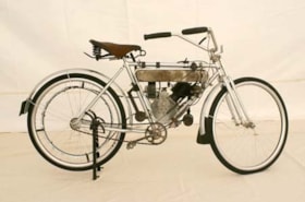
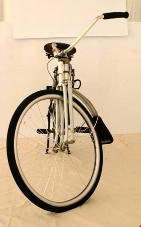
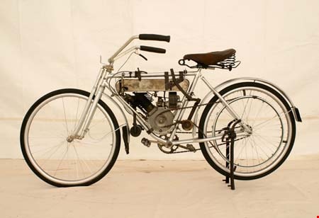
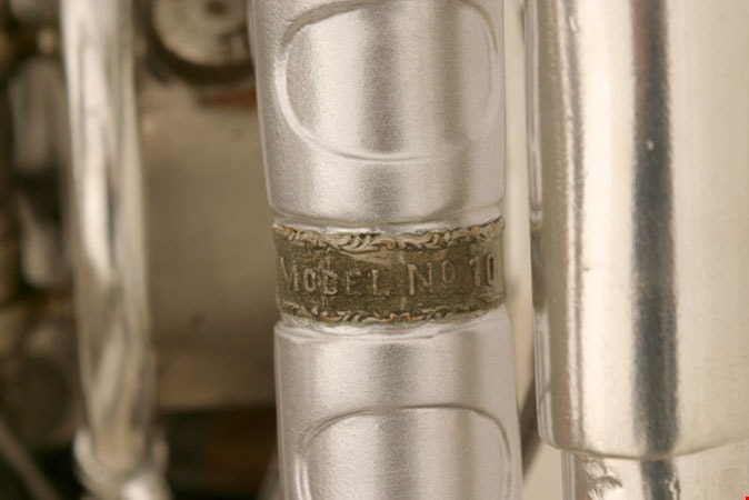
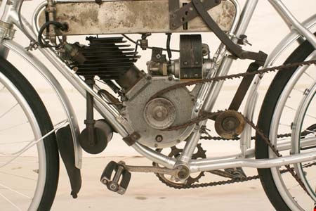
motorcycle
https://search.heritageburnaby.ca/link/museumartifact16269
- Repository
- Burnaby Village Museum
- Accession Code
- HV982.7.1
- Description
- Motorcycle, made by the Canadian Cycle and Motor Co. (CCM). It was manufactured ca 1911, and it is identified as a Model 10. The serial number on engine is, M.T. 11098. The motorcycle has a bicycle style tubular, metal frame. The engine and fuel tank are mounted inside the frame. A leather link chain runs from the engine pulley to a large drive pulley on the rear wheel. The motorcycle is equipped with bicycle style pedals as well as the engine.
- Object History
- Original owner's name found on bicycle by CCI staff in Ottawa. Last licenced 1923. That owner died in a car accident in 1924.
- Country Made
- Canada
- Province Made
- Ontario
- Site/City Made
- Weston
Images


![Survey and Subdivision plans in New Westminster District Group 1 and Group 2 – Vancouver, ʷməθkʷəy̓əm (Musqueam) Indian Reserve, Burnaby, Surrey
, [1910-1911] thumbnail](/media/hpo/_Data/_BVM_Cartographic_Material/1977/1977_0093_0017_001.jpg?width=280)
Survey and Subdivision plans in New Westminster District Group 1 and Group 2 – Vancouver, ʷməθkʷəy̓əm (Musqueam) Indian Reserve, Burnaby, Surrey
https://search.heritageburnaby.ca/link/museumdescription6986
- Repository
- Burnaby Village Museum
- Date
- [1910-1911]
- Collection/Fonds
- Burnaby Village Museum Map collection
- Description Level
- File
- Physical Description
- 9 plans : 4 plans : blueprint ink on paper + 4 plans : black ink on paper + 1 plan : graphite on paper mounted on 2 sides of cardboard 76 x 102 cm
- Scope and Content
- File consists of a large board of three survey plans in New Westminster District Group 1 mounted on one side and six survey and subdivision plans of District Lot 85, New Westminster District Group 1 mounted on the other side. Side A: 1. Plan : blueprint on paper ; 30.5 x 80 cm. Title reads: "Fras…
- Repository
- Burnaby Village Museum
- Collection/Fonds
- Burnaby Village Museum Map collection
- Description Level
- File
- Physical Description
- 9 plans : 4 plans : blueprint ink on paper + 4 plans : black ink on paper + 1 plan : graphite on paper mounted on 2 sides of cardboard 76 x 102 cm
- Material Details
- Scales vary (One chain equals 792 inches)
- Indexed number on tape on edge of board reads "17"
- Scope and Content
- File consists of a large board of three survey plans in New Westminster District Group 1 mounted on one side and six survey and subdivision plans of District Lot 85, New Westminster District Group 1 mounted on the other side. Side A: 1. Plan : blueprint on paper ; 30.5 x 80 cm. Title reads: "Fraser River Bridge / Plan of South Approach". Plan covers area of land north of the Fraser River and Great Northern Railway with approach for a bridge running through the "ʷməθkʷəy̓əm (Musqueam) Indian Reserve" (ʷməθkʷəy̓əm (Musqueam) First Nation) and lots marked as Dominion Government and the east half of Lot 2 identified as "C. F. Brown" "Plan 851". Plan is identified as "Plan 851 / traced / Mar. 17, 1911". (Geographic location in Vancouver) Scale: 100 feet = 1 inch, Signed by Albert J. Hill / P.L.S." 2. Plan : blueprint on paper ; 36.5 x 35 cm (no title). Includes three plans of lots on the east and west sides of North Road. Note on bottom of blueprint reads: "I.E.B. McKay Surveyor General - hereby certify / that this is a correct tracing from the field / notes of the Royal Engineers on file in the / Lands Department / E.B. McKay (signature) / Surveyor General / Victoria B.C. April 11th 1911" . Plan in top left titled "Page 11 / Vol. 1. / R.E. Notes" covers District Lots east of North Road including Lot 5, Lot 7, Lot 41, Lot 9 and Lot 107 in Coquitlam. Plan in top right corner titled "Page 17 / Vol. 1. / R.E. Notes" covers District Lots east of North Road including Lot 104, Lot 54, Lot 105, Lot 55, Lot 106, Lot 9 and Lot 107 in Coquitlam and Port Moody. Plan in lower left corner titled "Page 15 / Vol. 1 / R.E. Notes" covers District Lots west of North Road including Lot 147, Lot 148, Lot 100, Lot 15 in Burnaby. 3. Plan : blue print on paper ; 29.5 x 41.5 cm. (no formal title). Plan of the North 1/2 of Section 18. Plan covers area in the "North 1/2 of Sec.18 B.5 N RGE 1 W" and "Sec. 18 B.5 N. RGE 1 W" bordered by Section 7, Section 13, Section 17 and Section 19. Bon Accord Road runs through Sec. 18. The plan is signed by surveryor "I.H. Neville Smith... C.E.B.C.L.S. / Mar. 26th 1910" and signed by "Ludwig Pillath". (Geographic location: Surrey) Side B: 1. Plan : blueprint on paper ; 43.5 x 49.5 cm. Title reads: "Plan / of Subdivision / of a Portion / of / Lot 85 / Group One / New Westminster District. Plan covers portion of land east of Deer Lake and Pole Line Road (Sperling Avenue) and south of Hastings Road in District Lot 85 in Burnaby with section 4 and a portion of section 2 coloured in red. Plan is signed by "Albert J. Hill, B.C.L.S." Plan is initialed by: "RB" [sic] (in blue pencil crayon) Scale: 4 chains = 1 inch 2. Plaln : black black ink on linen ; 39 x 37 cm. Title reads: "L.C. Hill's Property, / Burnaby". Plan covers a triangular portion of land east of Pole Line Road (Sperling Avenue) and south of Hastings Road in District Lot 85 in Burnaby. Plan is intitaled by "RB" [sic] (in blue pencil crayon). Scale: 3 chains = 1 mile 3. Plan : graphite on paper ; 23 x 17 cm. Title reads: "Portion of Lot 85 / Gr.1". Plan covers portion of land north east of Deer Lake and west of Pole Line Road (now Sperling Avenue) in District Lot 85 in Burnaby. Plan is stamped in red ink: "Albert J. Hill, Civil Engineer". Plan is initialed by: "RB" [sic] (in blue pencil crayon). Scale: 1 chain = 1 inch 4. Plan : black ink on linen ; 16 x 19 cm. Title reads: "Lot 85". Plan covers the intersection of Pole Line Road (Sperling Avenue) and Hastings Road at the north west section of District Lot 79 and District Lot 85 in Burnaby. Plan is stamped: "A.J. Hill, Civil Engineer" with identitifed in blue pencil crayon. 5. Plan : black ink on paper ; 28.5 x 37 cm. (no formal title) Plan covers an area of land, west of Pole Line Road (Sperling Avenue) and south of Deer Lake in District Lot 85 in Burnaby. Plan is initialed by: "RB" [sic] (in blue pencil crayon) 6. Plan : black ink on paper ; 21 x 34 cm (no formal title). Plan covers an area of land, west of Pole Line Road (Sperling Avenue) and south of Deer Lake in District Lot 85 in Burnaby. Plan is initialed by: "RB" [sic] (in blue pencil crayon)
- Accession Code
- HV977.93.17
- Access Restriction
- No restrictions
- Reproduction Restriction
- No known restrictions
- Date
- [1910-1911]
- Media Type
- Cartographic Material
- Historic Neighbourhood
- Burnaby Lake (Historic Neighbourhood)
- Burquitlam (Historic Neighbourhood)
- Planning Study Area
- Morley-Buckingham Area
- Douglas-Gilpin Area
- Scan Resolution
- 600
- Scan Date
- 2023-06-26
- Notes
- Title based on contents of file
- Scale is measured in chains and feet. (One chain equals 792 inches).
- The term "Lot" also refers to a "District Lot”
- Some plans are stamped: "Albert J. Hill, Civil Engineer / and / Provincial Land Surveyor, / New Westminster, / B.C." and intialed: "RB" [sic]
Zoomable Images
![Survey and Subdivision plans in New Westminster District Group 1 and Group 2 – Vancouver, ʷməθkʷəy̓əm (Musqueam) Indian Reserve, Burnaby, Surrey
, [1910-1911] thumbnail](/media/hpo/_Data/_BVM_Cartographic_Material/1977/1977_0093_0017_003_seadragon/1977_0093_0017_003.jpg?w=280)
Survey and Subdivision plans in New Westminster District Group 1 and Group 2 – Vancouver, ʷməθkʷəy̓əm (Musqueam) Indian Reserve, Burnaby, Surrey , [1910-1911]
Zoom into Image
![Survey and Subdivision plans in New Westminster District Group 1 – Burnaby, [1905-1909] thumbnail](/media/hpo/_Data/_BVM_Cartographic_Material/1977/1977_0093_0024a_001.jpg?width=280)
Survey and Subdivision plans in New Westminster District Group 1 – Burnaby
https://search.heritageburnaby.ca/link/museumdescription6993
- Repository
- Burnaby Village Museum
- Date
- [1905-1909]
- Collection/Fonds
- Burnaby Village Museum Map collection
- Description Level
- File
- Physical Description
- 11 plans : 8 plans : black ink on paper + 2 plans : graphite on paper + 1 plan : graphite and ink on paper mounted on 2 sides of cardboard 76 x 102 cm
- Scope and Content
- Item consists of a large board of seven New Westminster District subdivision plans mounted on one side and four New Westminster District subdivision plans mounted on the other side. Side A: 1. Small subdivision plan of "Lot 2, Gr.1" drawn in black ink with annotation "Now Lot 1 of Subd of Lot 2 /…
- Repository
- Burnaby Village Museum
- Collection/Fonds
- Burnaby Village Museum Map collection
- Description Level
- File
- Physical Description
- 11 plans : 8 plans : black ink on paper + 2 plans : graphite on paper + 1 plan : graphite and ink on paper mounted on 2 sides of cardboard 76 x 102 cm
- Material Details
- Scales [between 1:1200 and 1:3600]
- Index number on edge of board reads: "24"
- Scope and Content
- Item consists of a large board of seven New Westminster District subdivision plans mounted on one side and four New Westminster District subdivision plans mounted on the other side. Side A: 1. Small subdivision plan of "Lot 2, Gr.1" drawn in black ink with annotation "Now Lot 1 of Subd of Lot 2 / see Bd. 5". Plan is initialed by: "RB" [sic] (in blue pencil crayon) with "Scale 3 ch = 1 in" and signed by "Albert J. Hill / P.L.S." (in graphite). (Geographic location: Burnaby) 2. Plan of "Lot 43, G.1" north of Burnaby Lake and surrounded by Lot 59, Lot 44, Lot 42. Lot 43 identifies physical features including: " roads / beaver dam / cranberry bog / roads / large brook / cutting / spruce / cedar / vine paper and alder / cedar / light spruce". Lot 59 identifies physical features: "heavy timber / alder and cedar etc" (Geographic location: Burnaby) 3. "Plan / Shewing Subdivision of part of / Lot 156 G.1 / Burnaby / N.W.D. / BC / Scale 300 ft = 1 inch" Annotation at top of plan reads: "#1030_Deposited / in the Land Registry Office / at New Westminster BC / 24th February 1908 / C.S. Keith Dist Reg I / RB". Plan is signed by "Peter Byrne / Reeve" and "H.G. Youdall [sic] _ BCLS" (Geographic location: Burnaby) 4. "Plan / of / Subdivision of Part / Lot 25, Group 1, N.W.D. / Burnaby Municipality / Scale: 3 chains = 1 inch" (drawn in graphite). Plan is initialed by: "RB" [sic] (in blue pencil crayon) and signed by "H.N. Smith" and "1024 / Deposited 25th / Jan. 1908 / Keith" (graphite) (Geographic location: Burnaby) 5. Handrawn plan in graphite is identified as "Lots 89 & 90 Gr.1" and intialed "RB" [sic] (in blue pencil crayon) (Geographic location: Burnaby) 7. Plan of "Lot 95 Gr. 1". Plan includes a portion of District Lot 95 near the intersection of centre line of B.C.E.R. and B.C.E.Ry - Vancouver Road. Plan is stamped: "Albert J. Hill, Civil Engineer / and / Provincial Land Surveyor, / New Westminster, / B.C." and initialed by "RB" [sic] (in blue pencil crayon) (Geographic location: Burnaby) 6. "Plan of Subdivision / of Sub Lot XI, Block 11 / DL 25, Gr.1 / (Burnaby) / N.W.D. / Scale 100 feet = 1 inch". Plan is dated "May 13, 1909" and signed by "W.R. Williams / Owner _ H.M. Smith" . Plan is initialed by: "RB" [sic] (in blue pencil crayon) (Geographic location: Burnaby) Side B: 1. "Plan / of Subdivision / of / Block "F" / in the Subdivision / of / Lot 29, Group 1. / New Westminster District / Scale 2chs = 1in" . Plan is stamped: "Albert J. Hill, Civil Engineer / and / Provincial Land Surveyor, / New Westminster, / B.C.". Plan is initialed by: "RB" [sic] (in blue pencil crayon) (Geographic location: Burnaby) 2. Plan of "Portion Lot B Gr.1". Plan includes annotations in graphite reading: "See Board 52-8 & 56-53" / "Sketch / see orig. plan". Plan is stamped: "Albert J. Hill, Civil Engineer / and / Provincial Land Surveyor, / New Westminster, / B.C." and is initialed by: "RB" [sic] (in blue pencil crayon) 3. Untitled plan drawn in black ink showing the "Brunette River", the "V.W. & Y.RY" and "Gunn Road _Diversion" running through Lot 13, Lot 2 - H.Gunn, Lot 4 - A.Lewis, Lot 10 - Geo. Love and W. Leonard and Lot 40. Plan is stamped: "Albert J. Hill, Civil Engineer / and / Provincial Land Surveyor, / New Westminster, / B.C." and initialed by "RB" [sic] (in blue pencil crayon) (Geographic location: Burnaby) 4."Plan / of / a Portion of the Foreshore / of / The North Arm of the Fraser River / Fronting / A Portion of Lot 166 Gr.1 / N.W. Dist. B.C. / Scale 100' = 1 " / Soundings taken from Map of D.P.W. Surveys". Plan is initialed by: "RB" [sic] (in blue pencil crayon) and includes annotations in red ink reading: "Office Copy" / "Plotted / Dec. 9th 1908 / G.K.B." (Geographic location: Burnaby)
- Creator
- Hill, Albert James
- Smith, H. Neville
- Accession Code
- HV977.93.24
- Access Restriction
- No restrictions
- Reproduction Restriction
- No known restrictions
- Date
- [1905-1909]
- Media Type
- Cartographic Material
- Historic Neighbourhood
- Burnaby Lake (Historic Neighbourhood)
- Fraser Arm (Historic Neighbourhood)
- Planning Study Area
- Burnaby Lake Area
- Scan Resolution
- 300
- Scale
- 72
- Notes
- Title based on contents of file
- Scale is measured in chains and feet. (One chain equals 792 inches)
- The term "Lot" can also refer to a "District Lot"
Images
![Survey and Subdivision plans in New Westminster District Group 1 – Burnaby, [1905-1909] thumbnail](/media/hpo/_Data/_BVM_Cartographic_Material/1977/1977_0093_0024a_001.jpg)


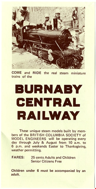
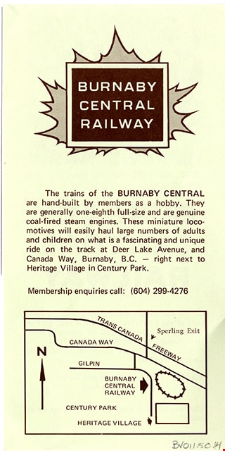
pamphlet
https://search.heritageburnaby.ca/link/museumartifact84653
- Repository
- Burnaby Village Museum
- Accession Code
- BV011.50.14
- Description
- pamphlet; light green paper; printed on two sides with brown ink; front includes title "BURNABY / CENTRAL / RAILWAY" with photograph of model steam engine above and information on the railway operation with fares; verso of pahmplet includes map with location of Burnaby Central Railway and contact information.
- Object History
- Burnaby Central Railway Project was constructed on the site of Heritage Village and was financed by the British Columbia Society of Model Engineers; Century Park Museum Association (via Burnaby Parks); Federal Government New Horizons Program and B.C. Goverment Recreation Facilities fund. British Columbia Society of Model Engineers (B.C.M.E.) operated the Burnaby Central Railway inside Heritage Village (Burnaby Village Museum) between 1975 and 1991.
- Measurements
- w: 10 cm h: 20 cm.
- Subjects
- Transportation - Rail
Images