Narrow Results By
Decade
- 2020s 7
- 2010s 5
- 2000s 3
- 1990s 45
- 1980s 3
- 1970s 149
- 1960s 3
- 1950s 14
- 1940s 22
- 1930s 10
- 1920s 11
- 1910s 10
- 1900s 10
- 1890s 3
- 1880s 1
- 1870s 1
- 1860s 1
- 1850s 1
- 1840s 1
- 1830s 1
- 1820s 1
- 1810s 1
- 1800s 1
- 1790s 1
- 1780s 1
- 1770s 1
- 1760s 1
- 1750s 1
- 1740s 1
- 1730s 1
- 1720s 1
- 1710s 1
- 1700s 1
- 1690s 1
- 1680s 1
- 1670s 1
- 1660s 1
- 1650s 1
- 1640s 1
- 1630s 1
- 1620s 1
- 1610s 1
- 1600s 1
Creator
- British Columbia Underwriters' Association 1
- Burnaby Village Museum 5
- Burnett & McGugan, Engineers and Surveyors 1
- City of Burnaby 3
- Columbian Photo Limited 5
- Crawford, T. James (Thomas James) 1
- Damer, Eric 1
- Debbie Liang 1
- Fong, Denise 1
- Garden, Hermon and Burwell 1
- Lessenberry, D. D. (David Daniel), 1896- 1
- Liang, Debbie 1
Interview with Kalwant Singh "Nadeem" Parmar
https://search.heritageburnaby.ca/link/museumdescription19346
- Repository
- Burnaby Village Museum
- Date
- [1600-2022] (interview content), interviewed 7 Oct. 2022
- Collection/Fonds
- Burnaby Village Museum fonds
- Description Level
- Item
- Physical Description
- 2 sound recordings (wav) (111 min., 51 sec.) + 1 sound recording (mp3) (111 min., 51 sec.)
- Scope and Content
- Item consists of a recording of an oral history interview with Kalwant Singh "Nadeem" Parmar conducted by interviewers, Anushay Malik and Rajdeep with assistance from Burnaby Village Museum Assistant Curator, Kate Petrusa. During the interview Kalwant Singh "Nadeem" Parmar discusses and provides in…
- Repository
- Burnaby Village Museum
- Collection/Fonds
- Burnaby Village Museum fonds
- Series
- Museum Oral Histories series
- Description Level
- Item
- Physical Description
- 2 sound recordings (wav) (111 min., 51 sec.) + 1 sound recording (mp3) (111 min., 51 sec.)
- Material Details
- Interviewers: Anushay Malik, Rajdeep Co Interviewer and technical support: Kate Petrusa Interviewee: Nadeem Parmar Location of Interview: Residence of Nadeem Parmar in Burnaby Interview Date: October 7, 2022 Total Number of tracks: 2 Total Length of all Tracks: 01:51:51 min Digital master recordings (wav) were recorded onto two separate audio tracks, edited and merged together and converted to mp3 for access on Heritage Burnaby
- Scope and Content
- Item consists of a recording of an oral history interview with Kalwant Singh "Nadeem" Parmar conducted by interviewers, Anushay Malik and Rajdeep with assistance from Burnaby Village Museum Assistant Curator, Kate Petrusa. During the interview Kalwant Singh "Nadeem" Parmar discusses and provides information on; his ancestral background, his education, his employment background, his experiences of racial discrimmination as a South Asian immigrant, saw mills established by South Asian relations in Paldi (Vancouver Island), in North Vancouver and Burnaby, family relations in the South Asian Canadian community and in regions in Punjab, the caste system, his literary works, locations of family homes in Burnaby, the architectural design of his house, personal stories and anecdotal information as a South Asian Canadian living and working in Canada. 00:00 – 01:45 The framework and purpose of the interview is explained to interviewee Nadeem Parmar by interviewers Rajdeep and Anushay Malik. The interviewers explain how the information from this interview can be drawn on for Burnaby Village Museum’s future exhibits and also how researchers will learn more about the history of the South Asian community in Burnaby through residents’ stories. Interview begins with Nadeem providing his full name "Kulwant Singh Parmar". He clarifies that his name was given to him by his grandfather who was a civil engineer and that his father also worked as a civil engineer. Nadeem expresses that he was born with a “silver spoon in his mouth” as a descendent of his maternal grandfather who was a successful landlord. Nadeem explains that when the Partition of India came into effect, (1947) he was 11 years old. He and his family left the partitioned side, his native village was located in Punjab and his forefathers were located in Rajasthan. 3:20 – 4:57 Nadeem explains further about his forefathers who came from Rajasthan. He shares information about his ancestor on his father’s side, named Vijay Singh who was friends with Emperor Jahangir. When fighting began against Jahangir he left the area to head to the middle of central India, then to the Punjab area with small states. As a clan, as a Parmar, he conveys there were about eleven or twelve villages with the same name. Interviewer, Anushay helps Nadeem to clarify the time period of this information. Nadeem refers to the time period being similar to the epic historical film “Moghal-e-Azam” and Anushay confirms the time period being the 1600s when they left Rajasthan. 4:58 – 10:59 Interviewer Anushay asks Nadeem to about his migration to Canada. Nadeem conveys that his first ancestor on his in-laws side of the family migrated around 1889. Further discussion ensues about reading Punjabi and how interviewer Rajdeep can read Punjabi and that she comes from the village of "Lakhpur" in Punjab. Rajdeep notes that “Lakhpur” is near "Phagwara". Nadeem clarifies that his village is "Panchat" and this family used to live in "Phagwara". and Nadeem and Rajdeep compare their familiarity and memories of the area. Nadeem conveys some of his comments in Punjabi and then changes to English. Nadeem recollects when the Japanese bombarded Shillong, he was around seven years old and attended missionary school. The only languages that were taught were English and Persian. Nadeem conveys that his mother had hopes of Nadeem becoming an army officer and moving up the ranks but Nadeem wasn’t interested. Nadeem attended college, graduated with a Bachelor of Science, BSC with Physics and Chemistry, followed by another Bachelor’s Degree in Political Science and finally a degree in his favourite subject in the language of Urdu. He completed these degrees in Punjab in Doaba College, Jalandher. Nadeem recollects how he started teaching but wasn’t getting paid very well. When he was at college, with encouragement from his professor, Veer Pankalia [sic] he began writing poetry and short plays. His professor also introduced him to a famous poet of Punjab, Mila Ram Offa [sic] and he gave him the name of Nadeem. Nadeem explains the meaning of the name “Nadeem” “…the one who know about it, inside out…” even though we generally think of the meaning being “friend” it’s not just about friend. 11:00 -24:48 Nadeem provides background information on how he ended up marrying his future wife who was born in India and immigrated to Canada with her family. Nadeem explains how the marriage was arranged through family relations that were already established in Punjab over a century ago. One of his wife’s ancestors, head of the family called “baniye” (traders) immigrated to Canada in [1899]. This relation returned to Punjab where he had nephews, the youngest of the nephews was Nadeem’s father (Lashman Singh Manhas) in law’s father (Sher Singh Manhas). He expresses that his wife’s ancestor couldn’t bring Nadeem’s father in law’s father since he was only 12 or 13 years old but he brought three of the nephews back to Canada with him. The nephews were named, Pola Singh, Ginaya Singh and Doman Singh (also named Dolmans). He describes how the group left India but it took them two to three years before they arrived in Canada. The group travelled to Burma, Indonesia and Hong Kong before landing in San Francisco. From San Francisco they walked and worked on the rail line before entering Canada and arriving in Grand Forks. The men got work on the construction of the Canadian Pacific Railway (CPR) and eventually made their way to the lower mainland. Nadeem conveys that the younger brother of Ginaya Singh, Maya Singh joined the others in Canada taking the same route, arriving in Bridal Falls where they were working at a saw mill and in CP rail construction. He describes Maya Singh as business minded and since he was too young to work in the mill, he began working as a cook and then began growing potatoes on land that he leased from a Dutch land owner. The local mill at Bridal Falls was facing bankruptcy and Maya Singh arranged to lease the mill, eventually buying it. From there the group moved their business to Strawberry Hill in Surrey and when the sale of logs declined, they moved over to Vancouver Island and established a sawmill with Doman Singh in the community of Paldi (originally known as Mayo Lumber) near Duncan. He explains further how the South Asian community helped each other like they did back home. He clarifies that his father in law’s father is the youngest cousin of Ginaya and Doman Singh and when he died, his father in law’s younger brother started Kashmir Lumber. Eventually his father in law (Lashman Singh Manhas) and the rest of the whole family including cousins and nephews were sponsored by their relations and immigrated to Canada. Nadeem explains how in 1959, his brother in law returned home to Punjab to get married, bringing his family with him. He tells of how during this time period, a marriage was arranged by his parents for him to marry his future wife. Nadeem recollects how this came to be. Nadeem and his wife Surjeet married in Punjab in December 1960, Nadeem was 24 years old and his wife was 18 years old. 24:49 – 39:42 Nadeem describes how he obtained his teaching degree from Ramgarhia College in Phagwara (located in the Kapurhtala district of Punjab) and after a disagreement with a teacher at home, he decided to go to England. He explains how he joined his brother who had moved to England and was working as a labourer. Nadeem tells of the difficulties he faced applying for a teaching job in England and how he had to go back to school to help with his English pronunciation. Nadeem explains that after taking this course, he got work teaching Grade two students which he felt was below his qualifications (he mentions that while living in Punjab, he was a Secondary School teacher) and the pay was very low. He discovered that his brother was making more money working as a labourer so Nadeem became discouraged and quit. When Nadeem couldn’t find work as a labourer, his brother advised him to shave off his beard. Nadeem conveys how difficult it was for him to shave off his beard and how once he was clean shaven he got work as a sweeper in a factory. He shares his experience of working in the factory and of how with his former education he got himself promoted to a more technical position. With encouragement from his employer, Nadeem enrolled in technical courses which lead to him obtaining an HNC Engineering Degree. He completed the course work in two years, obtaining skills in microwave communication becoming the senior test engineer at the factory. While working in this position, Nadeem shares how he suffered discrimination when he was passed over for a senior chief engineer position at the factory by a less educated and experienced employee. 39:43 – 53:38 Nadeem recollects how things changed for him in the 1970s. It began with his father in law (Lashman Singh Manhas) passing away in 1970 while he and his family were living on 18th Street in Burnaby. His father in law had been working at the saw mill, Kashmir Lumber Company in North Vancouver that was owned by his father in law’s younger brother (Kashmir Singh Manhas). The mill had burnt down and many of the workers lost everything. Nadeem confides that during this time, his wife was suffering from depression and wanted to be with her mother back in Canada now that her father had passed away. Nadeem emphasizes how his wife’s family (over 300 relatives) in Canada often get together every year on July 1st in Paldi near Duncan. In 1972, Nadeem arrived in Canada on his own to find work but was unsuccessful so he and his wife made plans to move to Uganda where he was offered a job. In 1973, when his visa didn’t come through for Uganda, Nadeem, his wife and two children decided to come to Canada. Nadeem describes that after several unsuccessful experiences to find skilled work in Canada, he eventually found work at Canadian National Telecommunications. During this time, Nadeem and his family lived with his father in law’s family at 5216 Pandora Street in Burnaby and in 1974, Nadeem purchased a house at 131 Fell Avenue in Burnaby. Nadeem provides further details of when the families lived at these different addresses and how in 1983 he had a house built on Woodsworth Street where he is still living now. He conveys some of the history of the lot where his current house resides including details on the lot subdivision, lot ownership and the cost of building his new house. Nadeem tells of how he designed his home with help from his son who was working as an apprentice with architect Arthur Erikson at the time. He describes the architectural interior as an open concept design, in an “L” shape in honour of his father “Lakhmir Singh”. Nadeem shares information on his mother’s name which was Jamna (prior to her marriage) and became Davinder Kaur after she was married. (Note: Jamna was her name before marriage. Traditionally after a woman is married, her husband’s family changes her first name because she is now considered a part of a new family). 53:39 – 58:56 Nadeem provides information on his career working as CNCP technician working with CPIC systems and how he was promoted to a new position. Nadeem inserts a quote from a Punjabi poem which he translates to English as “Somebody asked the blind people. What do you need? He said, do you need two eyes?, he said, what else do I need?”. Nadeem conveys how in 1986 his mother passed away so he went back home to the village of Lakhpur where his father and younger brother were living. His father and younger brother were on their own and in 1986 they decided to demolish the family home. He explains that there’s a college there now and that a library was built at this location in the name of his grandfather. 58:57 – 1:04:38 Nadeem shares how he suffered a heart attack in 1990 during the marriage ceremony of his son in Williams Lake. Nadeem talks about the complicated relations of the South Asian families and the saw mill owners in Paldi and comments on the problems with the caste system that provokes discrimination within the South Asian community. Nadeem refers to disputes that arose amongst mill owners and investors that included Kapoor Singh Siddoo, Mayo Singh, Gurdial Singh Teja and Ginaya Singh which caused problems amongst his family and also lead to Kapoor Singh selling his portion of the mill. Nadeem spells “Ginaya” Singh’s name and explains that this name is the nickname for “Krishna”. Nadeem provides his insight into the joint ownership of the saw mills located in Paldi and how the the joint ownership was dissolved in 1952. Nadeem clarifies that Ginaya Singh also left Paldi and that Ginaya Singh’s wife is his mother in law’s aunt and that he also moved to Burnaby. Nadeem explains the proper name spelling of mill owner “Mayo Singh” and that the correct spelling is actually “Mayan Singh” but he changed it to “Mayo” when it was mis-pronounced. Nadeem also comments on the problems that he encountered in 1970 on the pronunciation of his own name while living in England and at one point his employer referred to him as “Paul”. 1:04:39 – 1:18:50 Nadeem relays that when he emigrated from India and to Canada that he carried his personal possessions in a small suitcase made from cardboard since the weight limit on the airplane was just three pounds. He conveys that many of his relations have all suffered from heart problems including Ginaya Singh and his children. Nadeem shares that Ginaya Singh’s three sons all lived in Burnaby. Nadeem conveys that many South Asians lived in Burnaby and many worked at saw mills in North Vancouver and in the L&K sawmill near Pemberton. Nadeem explains further about the how the disagreements came to be between Mayo Singh and Kapoor Singh. He describes how each had a different business strategy in harvesting lumber and that there were feuds amongst the families. Nadeem provides further details on the root of the family feuds. Nadeem provides definitions for certain Punjabi terms that he’s using including “Mehta”(meaning lowest class of farmers, foreigner as well head as a title given to people of a clan living in the area) and ‘Panchat”, the name of his family village that was built and founded by five brothers and one nephew (Panj- meaning five and the sound “cht” meaning six). Nadeem explains that these terms were given to people from his own clan living in the area because it was small. Nadeem explains further about status that is based on money and the Punjabi terms “Parsu”, “Parsa” and “Pasaram” that are often used to describe a person. When you are poor the term “Parsu” is used and when you become rich the term “Pasaram” is used. Nadeem refers to Mayo Singh as a Pasaram as the second most successful millner in British Columbia, second to Frederick John Hart. Nadeem mentions that Ginaya Singh, elder brother to Mayo Singh helped provide the finances to start the mill and when there was a disagreement, Ginaya Singh left the mill business, moved his family to Burnaby and began working in insurance. Nadeem shares the sad story of Ginaya Singh’s sudden death (in 1953). Nadeem states that many of the people who left the mills at Paldi went to work at the Kapoor Mill in Burnaby and some relocated to the Interior of British Columbia. Nadeem mentions that his father in law (Lashman Singh Manhas) was able to purchase a house on 18th Street in along with other residences that he bought with his hard earned money working in the farms and mills, 16 hours per day, seven days a week. 1:18:51 – 1:32:04 Nadeem explains why he thinks that most South Asian people worked in the mills in the earlier days. Nadeem conveys that since Sikh men wore beards and turbans they encountered discrimination and were unable to get work in the business community. Nadeem shares his own personal experiences of wearing a turban and the discrimination he’s encountered while living in Scotland and Canada. Nadeem mentions that a defense committee was formed to protect the Gurdwaras and people’s homes from being vandalized due to racial discrimination. Nadeem describes some of the troubles that he’s encountered in his own neighbourhood when he had to call the police. Nadeem shares a personal experience just after 9/11 where he was the target of racial discrimination in the parking lot of Burnaby Lake. Nadeem emphasizes that he has experienced many incidents of racial discrimination, especially in the workplace and that this was not unusual for him. 1:32:05 – 1:36:19 Nadeem talks about his interest in writing and his many literary works including 12 novels that he’s written in Punjabi. Nadeem highlights a few books that he’s written including a book titled “Rape” and another one titled “Sponsorship” which conveys the complex nature of people immigrating to Canada. Nadeem mentions a particular book about AIDS, titled “Wide Net” that he’s been trying to get published. Nadeem speaks to the challenges and high costs of trying to get his works published. Nadeem provides a brief synopsis of his book “Wide Net”. Nadeem relays that this is a personal account of a gay couple that he knew where one of the partners died of AIDS and that the couple gave Nadeem permission to tell their tragic story. 1:36:20 – 1:51:51 Nadeem talks about his children and compares their experiences to his own as a South Asian immigrant. Nadeems talks about the accomplishments of his son, his daughter and grandchildren including their education and careers. Nadeem says that his children are well educated and well established in their careers. Nadeem’s children attended Capitol Hill Elementary School and North Burnaby High School in Burnaby. Nadeem shares specifics of his son’s career history. Nadeem expresses that he still considers Canada to be the best country for opportunities and that he prefers to live in Burnaby rather than Surrey and shares some personal anecdotes. Nadeem lists some local places that he’s shopped for South Asian groceries and spices rather than travelling to Surrey. He mentions shopping at Kelly Douglas, stores in Chinatown, small grocers on Capitol Hill, Patel’s on Commercial Drive and Main Street. As an aside Nadeem mentions that he worked as a security guard and the wages that he earned. Nadeem comments that he has been awarded various certificates and certifications from his education and career over the years, including a Bachelor of Science. The interviewers further express their interest in seeing the cardboard case that Nadeem brought with him when immigrating to Canada. In closing Nadeem states that his favourite food from back home was kheer (rice pudding).
- History
- Interviewee biography: Kalwant Singh "Nadeem" Parmar was born June 9, 1936, Chuck 138 in Lyalpur (India before 1947) to parents Lakhmir Singh Parmar and Davinder Kaur Jamana Parmar. Nadeem grew up in the village of Panchat in the northern region of Punjab, India. Nadeem married his wife Surjeet in Punjab in 1960. After marrying the couple immigrated to England where Nadeem was already working. While living in England, Nadeem and Surjeet had two children. After Surjeet's father died in Canada in 1972, Nadeem, Surjeet and their two children immgrated to Canada, joining Surjeet's family who were living in Burnaby. After Nadeem immigrated to Burnaby in 1973 he worked various jobs before working with CN/CP Telecommunications. Nadeem holds a Bachelor of Arts, Bachelor of Teaching from Punjab University and a diploma from the London Board of Education (L.B.E.) and a P.Eng. from Lancaster. He has seven books published in Punjabi, three in Urdu and is published in eight anthologies. He is fluent in Punjabi, Urdu, and Hindi. Interviewers' biographies: Anushay Malik is labor historian with a geographical focus on South Asia. Anushay studied at the University of London and was a research fellow at the International Institute of Social History in Amsterdam, Netherlands. In 2014, Anushay moved back to her native Pakistan and joined Lahore University of Management Services as an Assistant Professor. In 2023, Anushay is a visiting scholar at Simon Fraser University and lives in Burnaby with her family. Anushay was a co-curator of the Burnaby Village Museum exhibit “Truths Not Often Told: Being South Asian in Burnaby”. Rajdeep was born and raised in the Lower Mainland and is of Punjabi (South Asian) descent. She has an Associate of Arts degree in Asian Studies from Kwantlen Polytechnic University, a Bachelor of Arts (Hons.) in Anthropology from the University of British Columbia. She is a student in the Restoration of Natural Systems program at the University of Victoria. Rajdeep works at Simon Fraser University as a Program Assistant and as a researcher with the City of Burnaby. At Burnaby Village Museum, Rajdeep contributed to the exhibit “Truths Not Often Told: Being South Asian in Burnaby”.
- Creator
- Burnaby Village Museum
- Subjects
- Buildings - Commercial - Grocery Stores
- Buildings - Industrial - Saw Mills
- Buildings - Industrial - Factories
- Education
- Employment
- Industries - Logging/lumber
- Migration
- Occupations - Engineers
- Occupations - Millworkers
- Occupations - Teachers
- Occupations - Writers
- Persons - South Asian Canadians
- Social Issues
- Social Issues - Racism
- Names
- Parmar, Kalwant Singh "Nadeem"
- Kapoor Sawmills Limited
- Siddoo, Kapoor Singh
- Teja, Gurdial Singh
- Parmar, Surjeet Kaur
- Manhas, Ghania Singh
- Singh, Mayo
- Manhas, Kashmir Singh
- Manhas, Sher Singh
- Manhas, Budhan Kaur
- Manhas, Lashman Singh
- Responsibility
- Malik, Anushay
- Rajdeep
- Geographic Access
- Woodsworth Street
- Accession Code
- BV022.29.1
- Access Restriction
- No restrictions
- Reproduction Restriction
- No known restrictions
- Date
- [1600-2022] (interview content), interviewed 7 Oct. 2022
- Media Type
- Sound Recording
- Historic Neighbourhood
- Capitol Hill (Historic Neighbourhood)
- Planning Study Area
- Douglas-Gilpin Area
- Capitol Hill Area
- Related Material
- See also BV022.29.5 - Interview with Surjeet Kaur Parmar
- Notes
- Title based on contents of item
- Spelling of "Ginaya Singh" found as "Ghania Singh Manhas" in obituary and death certificate
- Interview is conducted in English with various segments of discussion in Punjabi
- Transcript of interview available upon request
Audio Tracks
Interview with Kalwant Singh
Interview with Kalwant Singh
https://search.heritageburnaby.ca/media/hpo/_Data/_BVM_Sound_Recordings/Oral_Histories/2022_0029_0001_003.mp3![Living room at Bernard Hill's house, [189-] (date of original), copied 1977 thumbnail](/media/hpo/_Data/_BVM_Images/1977/1977_0123_0040_001.jpg?width=280)
Living room at Bernard Hill's house
https://search.heritageburnaby.ca/link/museumdescription634
- Repository
- Burnaby Village Museum
- Date
- [189-] (date of original), copied 1977
- Collection/Fonds
- Burnaby Village Museum Photograph collection
- Description Level
- Item
- Physical Description
- 1 photograph : b&w ; 20.2 x 25.2 cm print
- Scope and Content
- Photograph of the living room at Bernard Hill's house which was built in 1892 on Douglas Road, later renamed in part Canada Way. Prominent in the photograph is the wallpaper with floral motif and a piano with the top cluttered with vases, plates, framed photographs, etc. The piano stool has an an…
- Repository
- Burnaby Village Museum
- Collection/Fonds
- Burnaby Village Museum Photograph collection
- Description Level
- Item
- Physical Description
- 1 photograph : b&w ; 20.2 x 25.2 cm print
- Scope and Content
- Photograph of the living room at Bernard Hill's house which was built in 1892 on Douglas Road, later renamed in part Canada Way. Prominent in the photograph is the wallpaper with floral motif and a piano with the top cluttered with vases, plates, framed photographs, etc. The piano stool has an antimacassar, and there is a chair to the left side. Also visible on the left side is a fireplace. This photograph is cropped and reproduced in Michael Sone's book, "Pioneer Tales of Burnaby," pg. 27.
- Subjects
- Furniture
- Musical Instruments - Pianos
- Geographic Access
- Canada Way
- Street Address
- 4990 Canada Way
- Accession Code
- HV977.123.40
- Access Restriction
- No restrictions
- Reproduction Restriction
- No known restrictions
- Date
- [189-] (date of original), copied 1977
- Media Type
- Photograph
- Historic Neighbourhood
- Burnaby Lake (Historic Neighbourhood)
- Planning Study Area
- Douglas-Gilpin Area
- Scan Resolution
- 600
- Scan Date
- 2023-07-25
- Notes
- Title based on contents of photograph
Images
![Living room at Bernard Hill's house, [189-] (date of original), copied 1977 thumbnail](/media/hpo/_Data/_BVM_Images/1977/1977_0123_0040_001.jpg)
![Subdivision plans in New Westminster District Group 1 – Burnaby
, [1893-1910] thumbnail](/media/hpo/_Data/_BVM_Cartographic_Material/1977/1977_0093_0016a_001.jpg?width=280)
Subdivision plans in New Westminster District Group 1 – Burnaby
https://search.heritageburnaby.ca/link/museumdescription6985
- Repository
- Burnaby Village Museum
- Date
- [1893-1910]
- Collection/Fonds
- Burnaby Village Museum Map collection
- Description Level
- File
- Physical Description
- 4 plans : blueprint ink on paper mounted on 2 sides of cardboard 76 x 102 cm
- Scope and Content
- Item consists of a large board of two New Westminster District Gp 1 - subdivision plans mounted on one side and two New Westminster District Gp 1 - subdivision plans mounted on the other side. Side A: 1. Blueprint "Plan / of Subdivision / of / Lot 6 / Group One / New Westminster District / Scale…
- Repository
- Burnaby Village Museum
- Collection/Fonds
- Burnaby Village Museum Map collection
- Description Level
- File
- Physical Description
- 4 plans : blueprint ink on paper mounted on 2 sides of cardboard 76 x 102 cm
- Material Details
- Scales [between 1:1584 and 1:3960]
- Index number on edge of board reads: "16"
- Scope and Content
- Item consists of a large board of two New Westminster District Gp 1 - subdivision plans mounted on one side and two New Westminster District Gp 1 - subdivision plans mounted on the other side. Side A: 1. Blueprint "Plan / of Subdivision / of / Lot 6 / Group One / New Westminster District / Scale 5 chs = 1 in. / Map No 748" (Geographic location: Burnaby) 2. Blueprint "Plan / of Subdivision / of a Portion / of / Lot 29 / Group One / New Westminster Dist. / Scale 2 chs = 1 in. / Map No." Name identified in Block H is "Reichenbach" (Geographic location: Burnaby) Side B: 1. Blueprint "Plan / of Subdivision / of North 1/2 of Lot 80 / Group One / New Westminster District / Scale 3 chs = 1 in. / Map No 719" Plan is signed by: "Garden, Hermon & Burwell P.L.S. / Vancouver Jan. 23rd, 1893" (Geographic location: Burnaby) 2. Blueprint "Plan / of Subdivision / of Lot 79, Gr.1 / New Westminster Dist. / Scale 4 chas = 1 in. / Map No 536" Plan is signed by "Garden Hermon & Burwell / Provincial Land Surveyors". (Geographic location: Burnaby)
- Creator
- Garden, Hermon and Burwell
- Accession Code
- HV977.93.16
- Access Restriction
- No restrictions
- Reproduction Restriction
- No known restrictions
- Date
- [1893-1910]
- Media Type
- Cartographic Material
- Historic Neighbourhood
- Edmonds (Historic Neighbourhood)
- Burnaby Lake (Historic Neighbourhood)
- Planning Study Area
- Douglas-Gilpin Area
- Edmonds Area
- Cameron Area
- Scan Resolution
- 300
- Scale
- 72
- Notes
- Title based on contents of file
- Scale is measured in chains. (One chain equals 792 inches)
- The term "Lot" can also refer to a "District Lot”
Images
![Subdivision plans in New Westminster District Group 1 – Burnaby
, [1893-1910] thumbnail](/media/hpo/_Data/_BVM_Cartographic_Material/1977/1977_0093_0016a_001.jpg)

![Couple sitting on the steps, [190-?] (date of original), copied 1977 thumbnail](/media/hpo/_Data/_BVM_Images/1977/1977_0123_0004_001.jpg?width=280)
Couple sitting on the steps
https://search.heritageburnaby.ca/link/museumdescription598
- Repository
- Burnaby Village Museum
- Date
- [190-?] (date of original), copied 1977
- Collection/Fonds
- Burnaby Village Museum Photograph collection
- Description Level
- Item
- Physical Description
- 1 photograph : b&w ; 20.2 x 25.2 cm print
- Scope and Content
- Photograph of a young couple sitting together on the steps to a house that appears to be Bernard Hill home on Douglas Road near Deer Lake. The couple appears to be Arthur Rowe and his wife Winnie Hill Rowe (daughter of Bernard Hill). There is a person standing on the patio in the background.
- Repository
- Burnaby Village Museum
- Collection/Fonds
- Burnaby Village Museum Photograph collection
- Description Level
- Item
- Physical Description
- 1 photograph : b&w ; 20.2 x 25.2 cm print
- Scope and Content
- Photograph of a young couple sitting together on the steps to a house that appears to be Bernard Hill home on Douglas Road near Deer Lake. The couple appears to be Arthur Rowe and his wife Winnie Hill Rowe (daughter of Bernard Hill). There is a person standing on the patio in the background.
- Geographic Access
- Canada Way
- Street Address
- 4990 Canada Way
- Accession Code
- HV977.123.4
- Access Restriction
- No restrictions
- Reproduction Restriction
- No known restrictions
- Date
- [190-?] (date of original), copied 1977
- Media Type
- Photograph
- Historic Neighbourhood
- Burnaby Lake (Historic Neighbourhood)
- Planning Study Area
- Douglas-Gilpin Area
- Scan Resolution
- 600
- Scan Date
- 2023-07-18
- Notes
- Title based on contents of photograph
Images
![Couple sitting on the steps, [190-?] (date of original), copied 1977 thumbnail](/media/hpo/_Data/_BVM_Images/1977/1977_0123_0004_001.jpg)
![On the steps, [190-?] (date of original), copied 1977 thumbnail](/media/hpo/_Data/_BVM_Images/1977/1977_0123_0020_001.jpg?width=280)
On the steps
https://search.heritageburnaby.ca/link/museumdescription614
- Repository
- Burnaby Village Museum
- Date
- [190-?] (date of original), copied 1977
- Collection/Fonds
- Burnaby Village Museum Photograph collection
- Description Level
- Item
- Physical Description
- 1 photograph : b&w ; 25.2 x 20.2 cm print
- Scope and Content
- Photograph of people sitting together on the steps to a house. It appears to be the Bernard Hill home on Douglas Road (now Canada Way) near Deer Lake. There are four men, three women and one girl. The couple sitting in the back to the right side of the photograph is Arthur Rowe and Winnie Hill Ro…
- Repository
- Burnaby Village Museum
- Collection/Fonds
- Burnaby Village Museum Photograph collection
- Description Level
- Item
- Physical Description
- 1 photograph : b&w ; 25.2 x 20.2 cm print
- Scope and Content
- Photograph of people sitting together on the steps to a house. It appears to be the Bernard Hill home on Douglas Road (now Canada Way) near Deer Lake. There are four men, three women and one girl. The couple sitting in the back to the right side of the photograph is Arthur Rowe and Winnie Hill Rowe (daughter of Bernard Hill). The girl in a sailor shirt and pleated skirt sitting in the front appears to be Kitty Hill.
- Geographic Access
- Canada Way
- Street Address
- 4990 Canada Way
- Accession Code
- HV977.123.20
- Access Restriction
- No restrictions
- Reproduction Restriction
- No known restrictions
- Date
- [190-?] (date of original), copied 1977
- Media Type
- Photograph
- Historic Neighbourhood
- Burnaby Lake (Historic Neighbourhood)
- Planning Study Area
- Douglas-Gilpin Area
- Related Material
- For another photograph of the same group of women on the steps, see HV977.123.21
- Scan Resolution
- 600
- Scan Date
- 2023-07-18
- Notes
- Title based on contents of photograph
Images
![On the steps, [190-?] (date of original), copied 1977 thumbnail](/media/hpo/_Data/_BVM_Images/1977/1977_0123_0020_001.jpg)
![Women on the steps, [190-?] (date of original), copied 1977 thumbnail](/media/hpo/_Data/_BVM_Images/1977/1977_0123_0021_001.jpg?width=280)
Women on the steps
https://search.heritageburnaby.ca/link/museumdescription615
- Repository
- Burnaby Village Museum
- Date
- [190-?] (date of original), copied 1977
- Collection/Fonds
- Burnaby Village Museum Photograph collection
- Description Level
- Item
- Physical Description
- 1 photograph : b&w ; 25.2 x 20.2 cm print
- Scope and Content
- Photograph of a group of women sitting together on the steps to a house that appears to be Bernard Hill home on Douglas Road (now Canada Way) near Deer Lake. The three women, including Winnie Hill Rowe (daughter of Bernard Hill) on the right are sitting on the step just behind a girl in a sailor sh…
- Repository
- Burnaby Village Museum
- Collection/Fonds
- Burnaby Village Museum Photograph collection
- Description Level
- Item
- Physical Description
- 1 photograph : b&w ; 25.2 x 20.2 cm print
- Scope and Content
- Photograph of a group of women sitting together on the steps to a house that appears to be Bernard Hill home on Douglas Road (now Canada Way) near Deer Lake. The three women, including Winnie Hill Rowe (daughter of Bernard Hill) on the right are sitting on the step just behind a girl in a sailor shirt and pleated skirt sitting in the front, who appears to be Kitty Hill.
- Geographic Access
- Canada Way
- Street Address
- 4990 Canada Way
- Accession Code
- HV977.123.21
- Access Restriction
- No restrictions
- Reproduction Restriction
- No known restrictions
- Date
- [190-?] (date of original), copied 1977
- Media Type
- Photograph
- Historic Neighbourhood
- Burnaby Lake (Historic Neighbourhood)
- Planning Study Area
- Douglas-Gilpin Area
- Related Material
- For another photograph of the same group of women on the steps, see HV977.123.20
- Scan Resolution
- 600
- Scan Date
- 2023-07-25
- Notes
- Title based on contents of photograph
Images
![Women on the steps, [190-?] (date of original), copied 1977 thumbnail](/media/hpo/_Data/_BVM_Images/1977/1977_0123_0021_001.jpg)
![Having tea on the porch, [190-] (date of original), copied 1977 thumbnail](/media/hpo/_Data/_BVM_Images/1977/1977_0123_0025_001.jpg?width=280)
Having tea on the porch
https://search.heritageburnaby.ca/link/museumdescription619
- Repository
- Burnaby Village Museum
- Date
- [190-] (date of original), copied 1977
- Collection/Fonds
- Burnaby Village Museum Photograph collection
- Description Level
- Item
- Physical Description
- 1 photograph : b&w ; 20.2 x 25.2 cm print
- Scope and Content
- Photograph of a family having tea on the porch.There are two tables with tea and snacks, and some wicker chairs. An accompanying note in the accession file identifies the elderly man sitting on the rail as B.R. (Bernard Richard) Hill, and the man and the boy by the other side of the rail as Claude …
- Repository
- Burnaby Village Museum
- Collection/Fonds
- Burnaby Village Museum Photograph collection
- Description Level
- Item
- Physical Description
- 1 photograph : b&w ; 20.2 x 25.2 cm print
- Scope and Content
- Photograph of a family having tea on the porch.There are two tables with tea and snacks, and some wicker chairs. An accompanying note in the accession file identifies the elderly man sitting on the rail as B.R. (Bernard Richard) Hill, and the man and the boy by the other side of the rail as Claude (son of Bernard Hill) and his son Kenneth. One of the women, unclear which one, is identified as "Maude's mother."
- Subjects
- Furniture
- Geographic Access
- Canada Way
- Street Address
- 4990 Canada Way
- Accession Code
- HV977.123.25
- Access Restriction
- No restrictions
- Reproduction Restriction
- No known restrictions
- Date
- [190-] (date of original), copied 1977
- Media Type
- Photograph
- Historic Neighbourhood
- Burnaby Lake (Historic Neighbourhood)
- Planning Study Area
- Douglas-Gilpin Area
- Scan Resolution
- 600
- Scan Date
- 2023-07-25
- Notes
- Title based on contents of photograph
Images
![Having tea on the porch, [190-] (date of original), copied 1977 thumbnail](/media/hpo/_Data/_BVM_Images/1977/1977_0123_0025_001.jpg)
![Having tea on the porch, [190-] (date of original), copied 1977 thumbnail](/media/hpo/_Data/_BVM_Images/1977/1977_0123_0026_001.jpg?width=280)
Having tea on the porch
https://search.heritageburnaby.ca/link/museumdescription620
- Repository
- Burnaby Village Museum
- Date
- [190-] (date of original), copied 1977
- Collection/Fonds
- Burnaby Village Museum Photograph collection
- Description Level
- Item
- Physical Description
- 1 photograph : b&w ; 20.2 x 25.2 cm print
- Scope and Content
- Photograph of a family having tea on a porch. There are three women and a young man who is sitting on a wicker chair. The women are pouring tea by the table. The location has been identified as the Bernard Hill family veranda.
- Repository
- Burnaby Village Museum
- Collection/Fonds
- Burnaby Village Museum Photograph collection
- Description Level
- Item
- Physical Description
- 1 photograph : b&w ; 20.2 x 25.2 cm print
- Scope and Content
- Photograph of a family having tea on a porch. There are three women and a young man who is sitting on a wicker chair. The women are pouring tea by the table. The location has been identified as the Bernard Hill family veranda.
- Subjects
- Furniture
- Geographic Access
- Canada Way
- Street Address
- 4990 Canada Way
- Accession Code
- HV977.123.26
- Access Restriction
- No restrictions
- Reproduction Restriction
- No known restrictions
- Date
- [190-] (date of original), copied 1977
- Media Type
- Photograph
- Historic Neighbourhood
- Burnaby Lake (Historic Neighbourhood)
- Planning Study Area
- Douglas-Gilpin Area
- Scan Resolution
- 600
- Scan Date
- 2023-07-25
- Notes
- Title based on contents of photograph
Images
![Having tea on the porch, [190-] (date of original), copied 1977 thumbnail](/media/hpo/_Data/_BVM_Images/1977/1977_0123_0026_001.jpg)
![Hill brothers on a hay wagon, [190-] (date of original), copied 1977 thumbnail](/media/hpo/_Data/_BVM_Images/1977/1977_0123_0027_001.jpg?width=280)
Hill brothers on a hay wagon
https://search.heritageburnaby.ca/link/museumdescription621
- Repository
- Burnaby Village Museum
- Date
- [190-] (date of original), copied 1977
- Collection/Fonds
- Burnaby Village Museum Photograph collection
- Description Level
- Item
- Physical Description
- 1 photograph : b&w ; 20.2 x 25.2 cm print
- Scope and Content
- Photograph of three boys and a dog riding on a mound of hay on a wagon. There is a man leading the horse pulling the wagon. This photograph was reproduced in Michael Sone's book, "Pioneer Tales of Burnaby," pg. 31. The caption reads: "Hill brothers and pet dog hitching ride on hay wagon on father…
- Repository
- Burnaby Village Museum
- Collection/Fonds
- Burnaby Village Museum Photograph collection
- Description Level
- Item
- Physical Description
- 1 photograph : b&w ; 20.2 x 25.2 cm print
- Scope and Content
- Photograph of three boys and a dog riding on a mound of hay on a wagon. There is a man leading the horse pulling the wagon. This photograph was reproduced in Michael Sone's book, "Pioneer Tales of Burnaby," pg. 31. The caption reads: "Hill brothers and pet dog hitching ride on hay wagon on father's farm. Chap leading horse is probably remittance man often hired in those days." The description for photo 204-789, a cropped copy of this photo, identifies the boys as the Hill brothers Frank, Claude and Gerry and their pet dog riding on hay wagon on their father's farm.
- Subjects
- Animals - Dogs
- Agriculture - Farms
- Agriculture - Crops
- Occupations - Agricultural Labourers
- Transportation - Horses
- Transportation - Wagons
- Geographic Access
- Douglas Road
- Canada Way
- Street Address
- 4990 Canada Way
- Accession Code
- HV977.123.27
- Access Restriction
- No restrictions
- Reproduction Restriction
- No known restrictions
- Date
- [190-] (date of original), copied 1977
- Media Type
- Photograph
- Historic Neighbourhood
- Burnaby Lake (Historic Neighbourhood)
- Planning Study Area
- Douglas-Gilpin Area
- Scan Resolution
- 600
- Scan Date
- 2023-07-25
- Notes
- Title based on contents of photograph
Images
![Hill brothers on a hay wagon, [190-] (date of original), copied 1977 thumbnail](/media/hpo/_Data/_BVM_Images/1977/1977_0123_0027_001.jpg)
![Gathering by a house, [190-?] (date of original), copied 1977 thumbnail](/media/hpo/_Data/_BVM_Images/1977/1977_0123_0028_001.jpg?width=280)
Gathering by a house
https://search.heritageburnaby.ca/link/museumdescription622
- Repository
- Burnaby Village Museum
- Date
- [190-?] (date of original), copied 1977
- Collection/Fonds
- Burnaby Village Museum Photograph collection
- Description Level
- Item
- Physical Description
- 1 photograph : b&w ; 20.2 x 25.2 cm print
- Scope and Content
- Photograph of a large gathering of people, men, women and children, in fine dresses and suits by a house with a picket fence. An accompanying note in the accession file identifies the photograph as taken on "sister's wedding" (possibly Winnie Hill Rowe) waiting to go into reception at B.R. Hill's (…
- Repository
- Burnaby Village Museum
- Collection/Fonds
- Burnaby Village Museum Photograph collection
- Description Level
- Item
- Physical Description
- 1 photograph : b&w ; 20.2 x 25.2 cm print
- Scope and Content
- Photograph of a large gathering of people, men, women and children, in fine dresses and suits by a house with a picket fence. An accompanying note in the accession file identifies the photograph as taken on "sister's wedding" (possibly Winnie Hill Rowe) waiting to go into reception at B.R. Hill's (Bernard Richard Hill) house.
- Subjects
- Ceremonies - Weddings
- Geographic Access
- Douglas Road
- Canada Way
- Street Address
- 4990 Canada Way
- Accession Code
- HV977.123.28
- Access Restriction
- No restrictions
- Reproduction Restriction
- No known restrictions
- Date
- [190-?] (date of original), copied 1977
- Media Type
- Photograph
- Historic Neighbourhood
- Burnaby Lake (Historic Neighbourhood)
- Planning Study Area
- Douglas-Gilpin Area
- Scan Resolution
- 600
- Scan Date
- 2023-07-25
- Notes
- Title based on contents of photograph
Images
![Gathering by a house, [190-?] (date of original), copied 1977 thumbnail](/media/hpo/_Data/_BVM_Images/1977/1977_0123_0028_001.jpg)
![Survey and Subdivision plans in New Westminster District Group 1 – Burnaby
, [1908] thumbnail](/media/hpo/_Data/_BVM_Cartographic_Material/1977/1977_0093_0004a_001.jpg?width=280)
Survey and Subdivision plans in New Westminster District Group 1 – Burnaby
https://search.heritageburnaby.ca/link/museumdescription6973
- Repository
- Burnaby Village Museum
- Date
- [1908]
- Collection/Fonds
- Burnaby Village Museum Map collection
- Description Level
- File
- Physical Description
- 10 plans : blueprint ink on paper mounted on 2 sides of cardboard ; 76 cm x 102 cm
- Scope and Content
- Item consists of a large board of four New Westminster District Gp 1 - subdivision plans mounted on one side and six New Westminster District Gp 1 - subdivision plans mounted on the other side. Side A: 1. Blueprint "Plan / of - ReSubdivision / of / Lots 1-18 inclusive / Blocks 20 and 21 / in Sub…
- Repository
- Burnaby Village Museum
- Collection/Fonds
- Burnaby Village Museum Map collection
- Description Level
- File
- Physical Description
- 10 plans : blueprint ink on paper mounted on 2 sides of cardboard ; 76 cm x 102 cm
- Material Details
- Scales [between 1:792 and 1:4752]
- Index number on edge of board reads: "4"
- Scope and Content
- Item consists of a large board of four New Westminster District Gp 1 - subdivision plans mounted on one side and six New Westminster District Gp 1 - subdivision plans mounted on the other side. Side A: 1. Blueprint "Plan / of - ReSubdivision / of / Lots 1-18 inclusive / Blocks 20 and 21 / in Subdivision / of / Lot 53 -Gr.1 / New Westminster District" / "Subdivision Lot Numbers - Shown in Red". Plan is bordered by First Street / Jorgenson's Line / Fourth Avenue and Second Street with Fifith Avenue running through the centre. There is an index in the upper right corner of the plan. Planned is signed by "Peter Byrne" and "William R. Phillips" and dated July 28, 1908. (Geographic location: Burnaby) 2. Blueprint "Plan / of Subdivision / of / Lot 159 / and a Portion of Lot 158 / Group One / New Westminster District". Plan is bordered by Lots 96 and 97; South Wilson Street; North Arm Road and Lot 160 / Power House Road (Lot 155 A). B.C.E.R. Gilley Station is identified in the upper right corner of the plan. (Geographic location: Burnaby) 3. Blueprint plan identified as "Subdvs 10, L 88 and Lot 25, G. 1" Plan identifies Cumberland Street running from top to the bottom and a Ravine running alongside with the Jensen house, stable and barn. (Geographic location: Burnaby) 4. Blueprint Plan of "Lot 153. G. 1 /New Westminster District". Plan identifies the "New Westminster & Vancouver Tramway" and the "New Westminster and Vancouver Road" running through the plan of Lot 53. (Geographic location: Burnaby) Side B: 1. Blueprint plan of "Profile on Proposed North Rd. Diversion". 2. Blueprint plan (no title) showing wood lots north of Burnaby Lake and Brunette River and west of North Road. Various lots are identified as "Heavily Timbered" (Lot 57); "Splendid Fir and Cedar / Heavy Fir etc. / Fine Cedar" (Lots 143, 148); "Rough Light Timber," (Lot 56); "Some Fir and Cedar" (Lot 40). (Geographic location: Burnaby) 3. Blueprint "Plan / of Subdivision / of a Portion / of Lot 87, Gr.1 / New Westminster District". Plan is bordered by Burnaby Lake at the top and Hastings Road / Lot 86 at the bottom and Lot 90 to the east. "Albert J. Hill B.C.LotS." Annotation in ink reads: " J.A. Brownlee, B.C.L.S. / Subdivision / Map 1494 / Bd. 248". Plan is signed by "Peter Byrne, Reeve" (Geographic location: Burnaby) 4. Blueprint plan of Subdivisions along either side of Douglas Road including Lots 117; 119; 74; 80; 79 and 77. (Geographic location: Burnaby) 5. Blueprint "Plan / of / Subdivision of / Lot 27 / in Subdivision / of / Lot 30 / Group One / New Westminster District" Plan is bordered by Lot 26, Lot 28 and Hastings Rd. Lot 27 runs north of Edmonds Street. , "Albert J. Hill, B.C.LotS." (Geographic location: Burnaby) 6. Blueprint plan identified as a "Cultivated Orchard" including the names "W. Grace" and "G. Mead" located north of the North Arm Fraser River and west of "Twentieth Street_ City Boundary". Handwritten annotation in coloured pencil reads: "Portion of Lot 172" (Geographic location: Burnaby)
- Subjects
- Geographic Features - Forests
- Geographic Access
- Cumberland Street
- North Road
- Hastings Street
- Douglas Road
- Accession Code
- HV977.93.4
- Access Restriction
- No restrictions
- Reproduction Restriction
- No known restrictions
- Date
- [1908]
- Media Type
- Cartographic Material
- Historic Neighbourhood
- Burnaby Lake (Historic Neighbourhood)
- Fraser Arm (Historic Neighbourhood)
- Planning Study Area
- Douglas-Gilpin Area
- Burnaby Lake Area
- Scan Resolution
- 300
- Scale
- 72
- Notes
- Title based on contents of file
- Scale is measured in chains. (One chain equals 792 inches)
- The term "Lot" can also refer to a "District Lot”-
Images
![Survey and Subdivision plans in New Westminster District Group 1 – Burnaby
, [1908] thumbnail](/media/hpo/_Data/_BVM_Cartographic_Material/1977/1977_0093_0004a_001.jpg)

![B.R. Hill house, [1910] thumbnail](/media/hpo/_Data/_BVM_Images/1976/1976_0051_0001_001.jpg?width=280)
B.R. Hill house
https://search.heritageburnaby.ca/link/museumdescription740
- Repository
- Burnaby Village Museum
- Date
- [1910]
- Collection/Fonds
- Burnaby Village Museum Photograph collection
- Description Level
- Item
- Physical Description
- 1 photograph : b&w photogravure ; 8.1 x 10.7 cm
- Scope and Content
- Photograph is photogravure printed on paper of a house on the side of a path. The area appears wooded. The inscription and the accession register identify the house as the residence of Mr. and Mrs. B.R. Hill on Douglas Road, built about 1892, with an addition to the house built about 1905.
- Repository
- Burnaby Village Museum
- Collection/Fonds
- Burnaby Village Museum Photograph collection
- Description Level
- Item
- Physical Description
- 1 photograph : b&w photogravure ; 8.1 x 10.7 cm
- Material Details
- An annotation in pencil is written on the back of the photograph
- Scope and Content
- Photograph is photogravure printed on paper of a house on the side of a path. The area appears wooded. The inscription and the accession register identify the house as the residence of Mr. and Mrs. B.R. Hill on Douglas Road, built about 1892, with an addition to the house built about 1905.
- Subjects
- Buildings - Residential - Houses
- Geographic Access
- Canada Way
- Douglas Road
- Street Address
- 4990 Canada Way
- Accession Code
- HV976.51.1
- Access Restriction
- No restrictions
- Reproduction Restriction
- May be restricted by third party rights
- Date
- [1910]
- Media Type
- Photograph
- Historic Neighbourhood
- Burnaby Lake (Historic Neighbourhood)
- Planning Study Area
- Douglas-Gilpin Area
- Scan Resolution
- 600
- Scan Date
- 2023-06-20
- Notes
- Title based on contents of photograph
Images
![B.R. Hill house, [1910] thumbnail](/media/hpo/_Data/_BVM_Images/1976/1976_0051_0001_001.jpg)
![Survey and Subdivision plans in New Westminster District Group 1 and Group 2 – Vancouver, ʷməθkʷəy̓əm (Musqueam) Indian Reserve, Burnaby, Surrey
, [1910-1911] thumbnail](/media/hpo/_Data/_BVM_Cartographic_Material/1977/1977_0093_0017_001.jpg?width=280)
Survey and Subdivision plans in New Westminster District Group 1 and Group 2 – Vancouver, ʷməθkʷəy̓əm (Musqueam) Indian Reserve, Burnaby, Surrey
https://search.heritageburnaby.ca/link/museumdescription6986
- Repository
- Burnaby Village Museum
- Date
- [1910-1911]
- Collection/Fonds
- Burnaby Village Museum Map collection
- Description Level
- File
- Physical Description
- 9 plans : 4 plans : blueprint ink on paper + 4 plans : black ink on paper + 1 plan : graphite on paper mounted on 2 sides of cardboard 76 x 102 cm
- Scope and Content
- File consists of a large board of three survey plans in New Westminster District Group 1 mounted on one side and six survey and subdivision plans of District Lot 85, New Westminster District Group 1 mounted on the other side. Side A: 1. Plan : blueprint on paper ; 30.5 x 80 cm. Title reads: "Fras…
- Repository
- Burnaby Village Museum
- Collection/Fonds
- Burnaby Village Museum Map collection
- Description Level
- File
- Physical Description
- 9 plans : 4 plans : blueprint ink on paper + 4 plans : black ink on paper + 1 plan : graphite on paper mounted on 2 sides of cardboard 76 x 102 cm
- Material Details
- Scales vary (One chain equals 792 inches)
- Indexed number on tape on edge of board reads "17"
- Scope and Content
- File consists of a large board of three survey plans in New Westminster District Group 1 mounted on one side and six survey and subdivision plans of District Lot 85, New Westminster District Group 1 mounted on the other side. Side A: 1. Plan : blueprint on paper ; 30.5 x 80 cm. Title reads: "Fraser River Bridge / Plan of South Approach". Plan covers area of land north of the Fraser River and Great Northern Railway with approach for a bridge running through the "ʷməθkʷəy̓əm (Musqueam) Indian Reserve" (ʷməθkʷəy̓əm (Musqueam) First Nation) and lots marked as Dominion Government and the east half of Lot 2 identified as "C. F. Brown" "Plan 851". Plan is identified as "Plan 851 / traced / Mar. 17, 1911". (Geographic location in Vancouver) Scale: 100 feet = 1 inch, Signed by Albert J. Hill / P.L.S." 2. Plan : blueprint on paper ; 36.5 x 35 cm (no title). Includes three plans of lots on the east and west sides of North Road. Note on bottom of blueprint reads: "I.E.B. McKay Surveyor General - hereby certify / that this is a correct tracing from the field / notes of the Royal Engineers on file in the / Lands Department / E.B. McKay (signature) / Surveyor General / Victoria B.C. April 11th 1911" . Plan in top left titled "Page 11 / Vol. 1. / R.E. Notes" covers District Lots east of North Road including Lot 5, Lot 7, Lot 41, Lot 9 and Lot 107 in Coquitlam. Plan in top right corner titled "Page 17 / Vol. 1. / R.E. Notes" covers District Lots east of North Road including Lot 104, Lot 54, Lot 105, Lot 55, Lot 106, Lot 9 and Lot 107 in Coquitlam and Port Moody. Plan in lower left corner titled "Page 15 / Vol. 1 / R.E. Notes" covers District Lots west of North Road including Lot 147, Lot 148, Lot 100, Lot 15 in Burnaby. 3. Plan : blue print on paper ; 29.5 x 41.5 cm. (no formal title). Plan of the North 1/2 of Section 18. Plan covers area in the "North 1/2 of Sec.18 B.5 N RGE 1 W" and "Sec. 18 B.5 N. RGE 1 W" bordered by Section 7, Section 13, Section 17 and Section 19. Bon Accord Road runs through Sec. 18. The plan is signed by surveryor "I.H. Neville Smith... C.E.B.C.L.S. / Mar. 26th 1910" and signed by "Ludwig Pillath". (Geographic location: Surrey) Side B: 1. Plan : blueprint on paper ; 43.5 x 49.5 cm. Title reads: "Plan / of Subdivision / of a Portion / of / Lot 85 / Group One / New Westminster District. Plan covers portion of land east of Deer Lake and Pole Line Road (Sperling Avenue) and south of Hastings Road in District Lot 85 in Burnaby with section 4 and a portion of section 2 coloured in red. Plan is signed by "Albert J. Hill, B.C.L.S." Plan is initialed by: "RB" [sic] (in blue pencil crayon) Scale: 4 chains = 1 inch 2. Plaln : black black ink on linen ; 39 x 37 cm. Title reads: "L.C. Hill's Property, / Burnaby". Plan covers a triangular portion of land east of Pole Line Road (Sperling Avenue) and south of Hastings Road in District Lot 85 in Burnaby. Plan is intitaled by "RB" [sic] (in blue pencil crayon). Scale: 3 chains = 1 mile 3. Plan : graphite on paper ; 23 x 17 cm. Title reads: "Portion of Lot 85 / Gr.1". Plan covers portion of land north east of Deer Lake and west of Pole Line Road (now Sperling Avenue) in District Lot 85 in Burnaby. Plan is stamped in red ink: "Albert J. Hill, Civil Engineer". Plan is initialed by: "RB" [sic] (in blue pencil crayon). Scale: 1 chain = 1 inch 4. Plan : black ink on linen ; 16 x 19 cm. Title reads: "Lot 85". Plan covers the intersection of Pole Line Road (Sperling Avenue) and Hastings Road at the north west section of District Lot 79 and District Lot 85 in Burnaby. Plan is stamped: "A.J. Hill, Civil Engineer" with identitifed in blue pencil crayon. 5. Plan : black ink on paper ; 28.5 x 37 cm. (no formal title) Plan covers an area of land, west of Pole Line Road (Sperling Avenue) and south of Deer Lake in District Lot 85 in Burnaby. Plan is initialed by: "RB" [sic] (in blue pencil crayon) 6. Plan : black ink on paper ; 21 x 34 cm (no formal title). Plan covers an area of land, west of Pole Line Road (Sperling Avenue) and south of Deer Lake in District Lot 85 in Burnaby. Plan is initialed by: "RB" [sic] (in blue pencil crayon)
- Accession Code
- HV977.93.17
- Access Restriction
- No restrictions
- Reproduction Restriction
- No known restrictions
- Date
- [1910-1911]
- Media Type
- Cartographic Material
- Historic Neighbourhood
- Burnaby Lake (Historic Neighbourhood)
- Burquitlam (Historic Neighbourhood)
- Planning Study Area
- Morley-Buckingham Area
- Douglas-Gilpin Area
- Scan Resolution
- 600
- Scan Date
- 2023-06-26
- Notes
- Title based on contents of file
- Scale is measured in chains and feet. (One chain equals 792 inches).
- The term "Lot" also refers to a "District Lot”
- Some plans are stamped: "Albert J. Hill, Civil Engineer / and / Provincial Land Surveyor, / New Westminster, / B.C." and intialed: "RB" [sic]
Zoomable Images
![Survey and Subdivision plans in New Westminster District Group 1 and Group 2 – Vancouver, ʷməθkʷəy̓əm (Musqueam) Indian Reserve, Burnaby, Surrey
, [1910-1911] thumbnail](/media/hpo/_Data/_BVM_Cartographic_Material/1977/1977_0093_0017_003_seadragon/1977_0093_0017_003.jpg?w=280)
Survey and Subdivision plans in New Westminster District Group 1 and Group 2 – Vancouver, ʷməθkʷəy̓əm (Musqueam) Indian Reserve, Burnaby, Surrey , [1910-1911]
Zoom into Image
![Mathers house, [1912] (date of original), copied 1985 thumbnail](/media/hpo/_Data/_BVM_Images/1985/1985_0057_0001_001.jpg?width=280)
Mathers house
https://search.heritageburnaby.ca/link/museumdescription166
- Repository
- Burnaby Village Museum
- Date
- [1912] (date of original), copied 1985
- Collection/Fonds
- Burnaby Village Museum Photograph collection
- Description Level
- Item
- Physical Description
- 1 photograph : b&w ; 20.2 x 25.2 cm print
- Scope and Content
- Photograph of the Mathers house in 1912. There is a family (perhaps the W.J. Mathers family) sitting on the stone-walled patio. Note the electric power pole to the right side of the photograph located close to the house. The house is now part of the Deer Lake Park Complex and is used for various ar…
- Repository
- Burnaby Village Museum
- Collection/Fonds
- Burnaby Village Museum Photograph collection
- Description Level
- Item
- Physical Description
- 1 photograph : b&w ; 20.2 x 25.2 cm print
- Scope and Content
- Photograph of the Mathers house in 1912. There is a family (perhaps the W.J. Mathers family) sitting on the stone-walled patio. Note the electric power pole to the right side of the photograph located close to the house. The house is now part of the Deer Lake Park Complex and is used for various artistic and cultural activities. According to a note prepared by Kathleen and Eileen Mather, the house otherwise known as "Altnadene" was built in 1911-1912 for Mr. and Mrs. W.J. Mathers of New Westminster by architect F.W. Macey who lived on Douglas Road. The house was occupied by the family from late-1912 until mid-1935. The original photographs have been taken by professional photographers.
- Subjects
- Buildings - Residential - Houses
- Geographic Access
- Deer Lake Avenue
- Street Address
- 6490 Deer Lake Avenue
- Accession Code
- BV985.57.1
- Access Restriction
- No restrictions
- Reproduction Restriction
- No known restrictions
- Date
- [1912] (date of original), copied 1985
- Media Type
- Photograph
- Historic Neighbourhood
- Burnaby Lake (Historic Neighbourhood)
- Planning Study Area
- Douglas-Gilpin Area
- Scan Resolution
- 600
- Scan Date
- 2023-12-19
- Notes
- Title based on contents of photograph
Images
![Mathers house, [1912] (date of original), copied 1985 thumbnail](/media/hpo/_Data/_BVM_Images/1985/1985_0057_0001_001.jpg)
![Mathers house, [1913 or 1916] (date of original), copied 1985 thumbnail](/media/hpo/_Data/_BVM_Images/1985/1985_0057_0002_001.jpg?width=280)
Mathers house
https://search.heritageburnaby.ca/link/museumdescription167
- Repository
- Burnaby Village Museum
- Date
- [1913 or 1916] (date of original), copied 1985
- Collection/Fonds
- Burnaby Village Museum Photograph collection
- Description Level
- Item
- Physical Description
- 1 photograph : b&w ; 20.2 x 25.2 cm print
- Scope and Content
- Photograph of the Mathers house with two children on the stone-walled patio and a girl on the lawn. The house is now part of the Deer Lake Park Complex and is used for various artistic and cultural activities. According to a note prepared by Kathleen and Eileen Mathers, the house otherwise known as…
- Repository
- Burnaby Village Museum
- Collection/Fonds
- Burnaby Village Museum Photograph collection
- Description Level
- Item
- Physical Description
- 1 photograph : b&w ; 20.2 x 25.2 cm print
- Scope and Content
- Photograph of the Mathers house with two children on the stone-walled patio and a girl on the lawn. The house is now part of the Deer Lake Park Complex and is used for various artistic and cultural activities. According to a note prepared by Kathleen and Eileen Mathers, the house otherwise known as "Altnadene" was built in 1911-1912 for Mr. and Mrs. W.J. Mathers of New Westminster by architect F.W. Macey who lived on Douglas Road. The house was occupied by the family from late-1912 until mid-1935. he original photographs have been taken by professional photographers. The accession register dates the photograph ca. 1913 while the inscription dates it 1916. An annotation on the back of the photograph reads: "Altnadara [sic] 1916."
- Subjects
- Buildings - Residential - Houses
- Geographic Access
- Deer Lake Avenue
- Street Address
- 6490 Deer Lake Avenue
- Accession Code
- BV985.57.2
- Access Restriction
- No restrictions
- Reproduction Restriction
- No known restrictions
- Date
- [1913 or 1916] (date of original), copied 1985
- Media Type
- Photograph
- Historic Neighbourhood
- Burnaby Lake (Historic Neighbourhood)
- Planning Study Area
- Douglas-Gilpin Area
- Scan Resolution
- 600
- Scan Date
- 2023-12-19
- Notes
- Title based on contents of photograph
Images
![Mathers house, [1913 or 1916] (date of original), copied 1985 thumbnail](/media/hpo/_Data/_BVM_Images/1985/1985_0057_0002_001.jpg)
![Ladies at Fairacres, [1913] (date of original), copied 1978 thumbnail](/media/hpo/_Data/_BVM_Images/1977/197900340001.jpg?width=280)
Ladies at Fairacres
https://search.heritageburnaby.ca/link/museumdescription437
- Repository
- Burnaby Village Museum
- Date
- [1913] (date of original), copied 1978
- Collection/Fonds
- Burnaby Village Museum Photograph collection
- Description Level
- Item
- Physical Description
- 2 photographs : b&w ; 20.3 x 25.2 cm prints
- Scope and Content
- Photograph of a group of ladies standing in front of the Fairacres Mansion. Grace Ceperley is in the front, with one hand on her hip and the other hand holding a kerchief.
- Repository
- Burnaby Village Museum
- Collection/Fonds
- Burnaby Village Museum Photograph collection
- Description Level
- Item
- Physical Description
- 2 photographs : b&w ; 20.3 x 25.2 cm prints
- Scope and Content
- Photograph of a group of ladies standing in front of the Fairacres Mansion. Grace Ceperley is in the front, with one hand on her hip and the other hand holding a kerchief.
- Names
- Ceperley, Grace
- Geographic Access
- Deer Lake Avenue
- Street Address
- 6344 Deer Lake Avenue
- Accession Code
- HV979.34.1
- Access Restriction
- No restrictions
- Reproduction Restriction
- No known restrictions
- Date
- [1913] (date of original), copied 1978
- Media Type
- Photograph
- Historic Neighbourhood
- Burnaby Lake (Historic Neighbourhood)
- Planning Study Area
- Douglas-Gilpin Area
- Scan Resolution
- 600
- Scan Date
- 2023-09-12
- Notes
- Title based on contents of photograph
Images
![Ladies at Fairacres, [1913] (date of original), copied 1978 thumbnail](/media/hpo/_Data/_BVM_Images/1977/197900340001.jpg)

Deer Lake
https://search.heritageburnaby.ca/link/museumdescription3102
- Repository
- Burnaby Village Museum
- Date
- 1914
- Collection/Fonds
- Burnaby Village Museum Photograph collection
- Description Level
- Item
- Physical Description
- 1 photograph : b&w glass negative ; 16.0 x 20.9 cm
- Scope and Content
- Photograph of Deer Lake. An earlier catalogue record from 1988 notes that the view is of the north shore of Deer Lake, looking northeast. Also noted is that the Hart's boathouse is in view at the mouth of Deer Lake Brook, and that the Anderson and Mathers houses on can be seen on Deer Lake Avenue
- Repository
- Burnaby Village Museum
- Collection/Fonds
- Burnaby Village Museum Photograph collection
- Description Level
- Item
- Physical Description
- 1 photograph : b&w glass negative ; 16.0 x 20.9 cm
- Scope and Content
- Photograph of Deer Lake. An earlier catalogue record from 1988 notes that the view is of the north shore of Deer Lake, looking northeast. Also noted is that the Hart's boathouse is in view at the mouth of Deer Lake Brook, and that the Anderson and Mathers houses on can be seen on Deer Lake Avenue
- Geographic Access
- Deer Lake Avenue
- Deer Lake Brook
- Street Address
- 6490 Deer Lake Avenue
- 6344 Deer Lake Avenue
- 6450 Deer Lake Avenue
- Accession Code
- HV972.11.16
- Access Restriction
- No restrictions
- Reproduction Restriction
- No known restrictions
- Date
- 1914
- Media Type
- Photograph
- Historic Neighbourhood
- Burnaby Lake (Historic Neighbourhood)
- Planning Study Area
- Douglas-Gilpin Area
- Related Material
- For other shots of the Deer Lake in the same accession, see HV972.11.6 and HV972.11.18
- Scan Resolution
- 300
- Scan Date
- 14/8/2006
- Scale
- 100
- Notes
- Title based on contents of photograph
- 1 b&w contact print accompanying negative
Images


Douglas Road School site
https://search.heritageburnaby.ca/link/museumdescription11136
- Repository
- Burnaby Village Museum
- Date
- April 19, 1915
- Collection/Fonds
- Ronald G. Scobbie collection
- Description Level
- Item
- Physical Description
- 1 survey plan : blueprint on paper ; 56 x 54 cm
- Scope and Content
- Survey plan of "Douglas Road School Site / Burnaby Municipality" "Being Lot 21, of Blocks 1-5 inc. 11 & 12 of the subd. of north half of Lot 80, Group 1, New Westminster District".
- Repository
- Burnaby Village Museum
- Collection/Fonds
- Ronald G. Scobbie collection
- Description Level
- Item
- Physical Description
- 1 survey plan : blueprint on paper ; 56 x 54 cm
- Material Details
- Scale 40 feet = 1 inch
- Scope and Content
- Survey plan of "Douglas Road School Site / Burnaby Municipality" "Being Lot 21, of Blocks 1-5 inc. 11 & 12 of the subd. of north half of Lot 80, Group 1, New Westminster District".
- Creator
- McGugan, Donald Johnston
- Subjects
- Buildings - Schools
- Names
- Douglas Road School
- Responsibility
- Burnett & McGugan, Engineers and Surveyors
- Geographic Access
- Canada Way
- Street Address
- 4861 Canada Way
- Accession Code
- BV003.83.15
- Access Restriction
- No restrictions
- Reproduction Restriction
- No known restrictions
- Date
- April 19, 1915
- Media Type
- Cartographic Material
- Historic Neighbourhood
- Burnaby Lake (Historic Neighbourhood)
- Planning Study Area
- Douglas-Gilpin Area
- Scan Resolution
- 440
- Scan Date
- 22-Dec-2020
- Scale
- 100
- Notes
- Title based on contents of plan
- Note in black ink on verso of plan reads: "1747"
- Oath on plan reads: "I, D.G. McGugan..." "...and did person- ally superintend the survey..." "...completed on the 3rd day of April 1915"; signed by D.J. McGugan, notarized by "H.A. Eastman", sworn "...19th day of April 1915" "Burnett and McGugan" "B.C. Land Surveyors Etc. New Westminster, B.C.."
Images

![Deer Lake Drive, [1918] thumbnail](/media/hpo/_Data/_BVM_Images/1972/1972_0051_0012_001.jpg?width=280)
Deer Lake Drive
https://search.heritageburnaby.ca/link/museumdescription1085
- Repository
- Burnaby Village Museum
- Date
- [1918]
- Collection/Fonds
- Burnaby Village Museum Photograph collection
- Description Level
- Item
- Physical Description
- 1 photograph : b&w ; 12.9 x 32.9 cm
- Scope and Content
- Photograph is a panorama of Deer Lake Drive, including the Ceperley mansion and the surrounding grounds of the home to the left of the picture. The photograph, taken from the water tower, with Burnaby Lake in the background. In the midground, following the horizon line, power poles can be seen. Far…
- Repository
- Burnaby Village Museum
- Collection/Fonds
- Burnaby Village Museum Photograph collection
- Description Level
- Item
- Physical Description
- 1 photograph : b&w ; 12.9 x 32.9 cm
- Scope and Content
- Photograph is a panorama of Deer Lake Drive, including the Ceperley mansion and the surrounding grounds of the home to the left of the picture. The photograph, taken from the water tower, with Burnaby Lake in the background. In the midground, following the horizon line, power poles can be seen. Farm lands are visible leading down to the homes of the Andersons. An annotation on the back of the photo in pencil reads, "Deer Lake Dr." and an annotation in blue pen reads, "1918."
- Geographic Access
- Deer Lake Drive
- Deer Lake Avenue
- Street Address
- 6344 Deer Lake Avenue
- Accession Code
- HV972.51.12
- Access Restriction
- No restrictions
- Reproduction Restriction
- No known restrictions
- Date
- [1918]
- Media Type
- Photograph
- Historic Neighbourhood
- Burnaby Lake (Historic Neighbourhood)
- Planning Study Area
- Douglas-Gilpin Area
- Scan Resolution
- 600
- Scan Date
- 2023-04-04
Images
![Deer Lake Drive, [1918] thumbnail](/media/hpo/_Data/_BVM_Images/1972/1972_0051_0012_001.jpg)

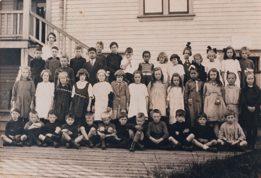
Students at Douglas Road School
https://search.heritageburnaby.ca/link/museumdescription1377
- Repository
- Burnaby Village Museum
- Date
- 1920
- Collection/Fonds
- Burnaby Village Museum Photograph collection
- Description Level
- Item
- Physical Description
- 1 photograph : sepia ; 17.5 x 25.5 cm print
- Scope and Content
- Photograph of Elsie Rummel (later McMurray) standing behind her students who are sitting and standing in rows outside Douglas Road school. Standing in the back two rows, left to right are; Jack Lort, Billy Mather, Teddy Norman (slightly in front), Ed Gavin, David Jung (slightly in front), Leonard R…
- Repository
- Burnaby Village Museum
- Collection/Fonds
- Burnaby Village Museum Photograph collection
- Description Level
- Item
- Physical Description
- 1 photograph : sepia ; 17.5 x 25.5 cm print
- Scope and Content
- Photograph of Elsie Rummel (later McMurray) standing behind her students who are sitting and standing in rows outside Douglas Road school. Standing in the back two rows, left to right are; Jack Lort, Billy Mather, Teddy Norman (slightly in front), Ed Gavin, David Jung (slightly in front), Leonard Rowley, Dave Banning, Herbert McConnell, Ying Jung, Gwendolyn Matthews, Avis Hart, Florence Cowan, Nancy Burnett, Winona Wood, Leona Smith, Sadie Bowie [or Dorothy Marsden]. Standing in the middle row are; Nora Rowley, Eva Dunnell [or Donnel], Rena Blomberg (later Ostby), Audrey [or Helen] Pontifex, Ruth Cole, Anna Matthews, Agnes Angus, Rhoda Gavin, Ruby Boucher, King Jung, Mary Lee, Frances "Fanny" Waplington (later Fleming), Beryl Hatch. Seated in the front row are; John Burnett [or Freddy Bogardus], John Waplington, Billy Townley, Roddie Saunders, Clive Cunningham, Ken Blott, Carl Banning, Doug Tyre, Bert Dawkins, Montague "Monty" Moore, John Moore and Alistair Westcott.
- Subjects
- Occupations - Teachers
- Names
- Douglas Road School
- McMurray, Elsie Rummel
- Lort, Jack
- Mather, Billy
- Norman, Teddy
- Gavin, Ed
- Jung, David
- Rowley, Leonard
- Banning, Dave
- McConnell, Herbert
- Jung, Suey Ying "Laura"
- Matthews, Gwendolyn
- Hart, Avis
- Cowan, Florence
- Burnett, Nancy
- Wood, Winona
- Smith, Leona
- Rowley, Nora
- Ostby, Rena Blomberg
- Cole, Ruth
- Matthews, Anna
- Angus, Agnes
- Gavin, Rhoda
- Boucher, Ruby
- Jung, King
- Lee, Mary
- Fleming, Frances "Fanny" Waplington
- Hatch, Beryl
- Waplington, John
- Townley, Billy
- Saunders, Roddie
- Cunningham, Clive
- Blott, Ken
- Banning, Carl
- Tyre, Doug
- Dawkins, Bert
- Moore, Montague Hutchings "Monty"
- Moore, John Gifford
- Westcott, Alistair
- Geographic Access
- Canada Way
- Street Address
- 4861 Canada Way
- Accession Code
- BV999.4.1
- Access Restriction
- No restrictions
- Reproduction Restriction
- No known restrictions
- Date
- 1920
- Media Type
- Photograph
- Historic Neighbourhood
- Burnaby Lake (Historic Neighbourhood)
- Planning Study Area
- Douglas-Gilpin Area
- Scan Resolution
- 600
- Scan Date
- 08-Jun-09
- Scale
- 100
- Notes
- Title based on contents of photograph
Images