Narrow Results By
Subject
- Advertising Medium 2
- Advertising Medium - Signs and Signboards 2
- Aerial Photographs 5
- Animals - Fowl 1
- Animals - Horses 2
- Armament 1
- Buildings - Civic - City Halls 1
- Buildings - Civic - Hospitals 3
- Buildings - Commercial - Grocery Stores 1
- Buildings - Commercial - Hotels and Motels 5
- Buildings - Commercial - Restaurants 1
- Buildings - Commercial - Train Stations 1
Creator
- Barrowclough, G.A. 1
- BC Photo Card Company 1
- Brown, W. 1
- Canadian Photo Company 14
- George Allen Aerial Photos Limited 4
- Gowen Sutton Company Limited 1
- Grant-Mann Lithographers Limited 1
- Henton, J.M. 1
- Hildred, Chris 1
- Hurndall, F. 1
- Printed on back of postcard: "Traveltime product. Made in Vancouver, Canada, by Grant-Mann Lithographers, Ltd." 1
- Scurr, Peter 1
![A Pretty Dwelling, Barnet, [191-] thumbnail](/media/hpo/_Data/_Archives_Images/_Unrestricted/540/540-027.jpg?width=280)
A Pretty Dwelling, Barnet
https://search.heritageburnaby.ca/link/archivedescription73619
- Repository
- City of Burnaby Archives
- Date
- [191-]
- Collection/Fonds
- LaFavor Family fonds
- Description Level
- Item
- Physical Description
- 1 photograph : sepia postcard ; 8.5 x 14 cm
- Scope and Content
- Photographic postcard of house in Barnet, BC, in which the image is entitled "A Pretty Dwelling."
- Repository
- City of Burnaby Archives
- Date
- [191-]
- Collection/Fonds
- LaFavor Family fonds
- Physical Description
- 1 photograph : sepia postcard ; 8.5 x 14 cm
- Description Level
- Item
- Record No.
- 540-027
- Access Restriction
- No restrictions
- Reproduction Restriction
- No restrictions
- Accession Number
- 2007-03
- Scope and Content
- Photographic postcard of house in Barnet, BC, in which the image is entitled "A Pretty Dwelling."
- Subjects
- Documentary Artifacts - Postcards
- Buildings - Residential - Houses
- Industries - Logging/lumber
- Names
- Barnet Mill
- Media Type
- Photograph
- Notes
- Transcribed title
- Geographic Access
- Barnet Village
- Texaco Drive
- Historic Neighbourhood
- Barnet (Historic Neighbourhood)
- Planning Study Area
- Burnaby Mountain Area
Images
![A Pretty Dwelling, Barnet, [191-] thumbnail](/media/hpo/_Data/_Archives_Images/_Unrestricted/540/540-027.jpg)

Armstrong Avenue school site
https://search.heritageburnaby.ca/link/archivedescription34064
- Repository
- City of Burnaby Archives
- Date
- 1911
- Collection/Fonds
- Burnaby Historical Society fonds
- Description Level
- Item
- Physical Description
- 1 photograph : b&w postcard ; 6.2 x 10.4 cm
- Scope and Content
- Photographic postcard of men sawing down a tree at the Armstrong Avenue School site at 8757 Armstrong Avenue. The accompanying description refers to it as the "bee tree."
- Repository
- City of Burnaby Archives
- Date
- 1911
- Collection/Fonds
- Burnaby Historical Society fonds
- Subseries
- Photographs subseries
- Physical Description
- 1 photograph : b&w postcard ; 6.2 x 10.4 cm
- Description Level
- Item
- Record No.
- 007-001
- Access Restriction
- No restrictions
- Reproduction Restriction
- No known restrictions
- Accession Number
- BHS2007-04
- Scope and Content
- Photographic postcard of men sawing down a tree at the Armstrong Avenue School site at 8757 Armstrong Avenue. The accompanying description refers to it as the "bee tree."
- Names
- Armstrong Avenue School
- Media Type
- Photograph
- Notes
- Title based on contents of photograph
- Postcard has been cropped
- Geographic Access
- Armstrong Avenue
- Street Address
- 8757 Armstrong Avenue
- Historic Neighbourhood
- East Burnaby (Historic Neighbourhood)
- Planning Study Area
- Cariboo-Armstrong Area
Images

At Union Street
https://search.heritageburnaby.ca/link/archivedescription34886
- Repository
- City of Burnaby Archives
- Date
- 1911
- Collection/Fonds
- Burnaby Historical Society fonds
- Description Level
- Item
- Physical Description
- 1 photograph : sepia postcard ; 8.5 x 13.8 cm
- Scope and Content
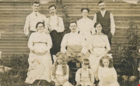
- Photographic postcard of a group of men, women and children outside at 4900 Union Street. Identified on the back of the postcard: Tom Simms, Municipal worker, upper right corner; and, Mirium Beckman, girl in lower right corner.
- Repository
- City of Burnaby Archives
- Date
- 1911
- Collection/Fonds
- Burnaby Historical Society fonds
- Subseries
- Olive Cullum subseries
- Physical Description
- 1 photograph : sepia postcard ; 8.5 x 13.8 cm
- Description Level
- Item
- Record No.
- 154-002
- Access Restriction
- No restrictions
- Reproduction Restriction
- No known restrictions
- Accession Number
- BHS1985-27
- Scope and Content
- Photographic postcard of a group of men, women and children outside at 4900 Union Street. Identified on the back of the postcard: Tom Simms, Municipal worker, upper right corner; and, Mirium Beckman, girl in lower right corner.
- Names
- Beckman, Mirium
- Simms, Tom
- Media Type
- Photograph
- Notes
- Title based on contents of photograph
- Geographic Access
- Union Street
- Street Address
- 4900 Union Street
- Planning Study Area
- Brentwood Area
Images

![BC Electric Towers, Barnet, BC, [191-] thumbnail](/media/hpo/_Data/_Archives_Images/_Unrestricted/540/540-003.jpg?width=280)
BC Electric Towers, Barnet, BC
https://search.heritageburnaby.ca/link/archivedescription73595
- Repository
- City of Burnaby Archives
- Date
- [191-]
- Collection/Fonds
- LaFavor Family fonds
- Description Level
- Item
- Physical Description
- 1 photograph : sepia postcard ; 8.5 x 14 cm
- Scope and Content
- Photographic postcard depicting the B.C. Electric Towers in Barnet, BC.
- Repository
- City of Burnaby Archives
- Date
- [191-]
- Collection/Fonds
- LaFavor Family fonds
- Physical Description
- 1 photograph : sepia postcard ; 8.5 x 14 cm
- Description Level
- Item
- Record No.
- 540-003
- Access Restriction
- No restrictions
- Reproduction Restriction
- No restrictions
- Accession Number
- 2007-03
- Scope and Content
- Photographic postcard depicting the B.C. Electric Towers in Barnet, BC.
- Media Type
- Photograph
- Photographer
- Canadian Photo Company
- Notes
- Transcribed title
- Geographic Access
- Barnet Village
- Historic Neighbourhood
- Barnet (Historic Neighbourhood)
- Planning Study Area
- Burnaby Mountain Area
Images
![BC Electric Towers, Barnet, BC, [191-] thumbnail](/media/hpo/_Data/_Archives_Images/_Unrestricted/540/540-003.jpg)

The Benedictines of Westminster Priory
https://search.heritageburnaby.ca/link/archivedescription38167
- Repository
- City of Burnaby Archives
- Date
- 1951 (date of original), copied 1991
- Collection/Fonds
- Burnaby Historical Society fonds
- Description Level
- Item
- Physical Description
- 1 photograph : b&w ; 3.3 x 5.3 cm print on contact sheet 20.1 x 26.3 cm
- Scope and Content
- Photograph of an original photographic postcard of the Benedictines of Westminster Priory at Ceperley House which was funded by the Catholic Diocese beginning in 1939. There is a postmark from Merritt, British Columbia, at the top right corner.
- Repository
- City of Burnaby Archives
- Date
- 1951 (date of original), copied 1991
- Collection/Fonds
- Burnaby Historical Society fonds
- Subseries
- Burnaby Image Bank subseries
- Physical Description
- 1 photograph : b&w ; 3.3 x 5.3 cm print on contact sheet 20.1 x 26.3 cm
- Description Level
- Item
- Record No.
- 370-754
- Access Restriction
- No restrictions
- Reproduction Restriction
- No restrictions
- Accession Number
- BHS1999-03
- Scope and Content
- Photograph of an original photographic postcard of the Benedictines of Westminster Priory at Ceperley House which was funded by the Catholic Diocese beginning in 1939. There is a postmark from Merritt, British Columbia, at the top right corner.
- Subjects
- Buildings - Religious
- Buildings - Heritage
- Occupations - Clergy
- Documentary Artifacts - Postcards
- Names
- Westminster Priory
- Media Type
- Photograph
- Notes
- 1 b&w copy negative accompanying
- Negative has a pink cast
- Annotation at bottom of photograph reads, "The Benedictines of Westminster Priory, Vancouver, BC"
- Geographic Access
- Deer Lake Avenue
- Street Address
- 6344 Deer Lake Avenue
- Historic Neighbourhood
- Burnaby Lake (Historic Neighbourhood)
- Planning Study Area
- Douglas-Gilpin Area
Images


B.G. Walker house
https://search.heritageburnaby.ca/link/archivedescription35002
- Repository
- City of Burnaby Archives
- Date
- 1910 (date of original), copied 1986
- Collection/Fonds
- Burnaby Historical Society fonds
- Description Level
- Item
- Physical Description
- 1 photograph : b&w postcard ; 8.4 x 13.8 cm
- Scope and Content
- Photographic postcard of the B.G. Walker house, Edmonds Street and Kingsway. Note the cedar stumps in background.
- Repository
- City of Burnaby Archives
- Date
- 1910 (date of original), copied 1986
- Collection/Fonds
- Burnaby Historical Society fonds
- Subseries
- Patterson family subseries
- Physical Description
- 1 photograph : b&w postcard ; 8.4 x 13.8 cm
- Description Level
- Item
- Record No.
- 171-023
- Access Restriction
- Open access
- Reproduction Restriction
- No known restrictions
- Accession Number
- BHS1986-20
- Scope and Content
- Photographic postcard of the B.G. Walker house, Edmonds Street and Kingsway. Note the cedar stumps in background.
- Media Type
- Photograph
- Notes
- Title based on contents of photograph
- Geographic Access
- Edmonds Street
- Kingsway
- Historic Neighbourhood
- Edmonds (Historic Neighbourhood)
Images

![Blue Haven Motel, [195-] thumbnail](/media/hpo/_Data/_Archives_Images/_Unrestricted/126/199-001.jpg?width=280)
Blue Haven Motel
https://search.heritageburnaby.ca/link/archivedescription35136
- Repository
- City of Burnaby Archives
- Date
- [195-]
- Collection/Fonds
- Burnaby Historical Society fonds
- Description Level
- Item
- Physical Description
- 1 photograph : col. postcard ; 8.9 x 13.9 cm
- Scope and Content
- Photographic postcard of the Blue Haven Motel, 7026 Kingsway. The description printed on the back of the postcard reads, "Blue Haven Motel / 7026 Kingsway, South Burnaby, B.C., Canada / Mrgs.: Mr. and Mrs. A. Pearson / 22 Units - 4 Stars - AAA - ACRA / T.V. Equipped / Telephone LA 1-9942." The bui…
- Repository
- City of Burnaby Archives
- Date
- [195-]
- Collection/Fonds
- Burnaby Historical Society fonds
- Subseries
- Photographs subseries
- Physical Description
- 1 photograph : col. postcard ; 8.9 x 13.9 cm
- Description Level
- Item
- Record No.
- 199-001
- Access Restriction
- No restrictions
- Reproduction Restriction
- Reproduce for fair dealing purposes only
- Accession Number
- BHS1987-10
- Scope and Content
- Photographic postcard of the Blue Haven Motel, 7026 Kingsway. The description printed on the back of the postcard reads, "Blue Haven Motel / 7026 Kingsway, South Burnaby, B.C., Canada / Mrgs.: Mr. and Mrs. A. Pearson / 22 Units - 4 Stars - AAA - ACRA / T.V. Equipped / Telephone LA 1-9942." The building on the left side of the photograph has "Office" written on the door. Cars and motel units are seen at the right.
- Names
- Blue Haven Motel
- Media Type
- Photograph
- Responsibility
- Printed on back of postcard: "Traveltime product. Made in Vancouver, Canada, by Grant-Mann Lithographers, Ltd."
- Notes
- Title based on contents of photograph
- Geographic Access
- Kingsway
- Street Address
- 7026 Kingsway
- Historic Neighbourhood
- Edmonds (Historic Neighbourhood)
- Planning Study Area
- Stride Avenue Area
Images
![Blue Haven Motel, [195-] thumbnail](/media/hpo/_Data/_Archives_Images/_Unrestricted/126/199-001.jpg)

Burnaby Mountain Park
https://search.heritageburnaby.ca/link/archivedescription37403
- Repository
- City of Burnaby Archives
- Date
- 1970
- Collection/Fonds
- Burnaby Historical Society fonds
- Description Level
- Item
- Physical Description
- 1 photograph : col. postcard ; 9 x 14 cm
- Scope and Content
- Photograph of Burnaby Mountain Park looking west towards Vancouver. The caption on the back of the postcard reads: "This view was taken from Burnaby Mountain Park, which is adjacent to Simon Fraser University. Some of the most spectacular views can be seen from this high elevation."
- Repository
- City of Burnaby Archives
- Date
- 1970
- Collection/Fonds
- Burnaby Historical Society fonds
- Subseries
- Robert Prittie subseries
- Physical Description
- 1 photograph : col. postcard ; 9 x 14 cm
- Description Level
- Item
- Record No.
- 369-002
- Access Restriction
- No restrictions
- Reproduction Restriction
- Reproduce for fair dealing purposes only
- Accession Number
- BHS1999-01
- Scope and Content
- Photograph of Burnaby Mountain Park looking west towards Vancouver. The caption on the back of the postcard reads: "This view was taken from Burnaby Mountain Park, which is adjacent to Simon Fraser University. Some of the most spectacular views can be seen from this high elevation."
- Media Type
- Photograph
- Photographer
- Weinhaupl, George
- Notes
- Title based on contents of photograph
- Geographic Access
- Burnaby Mountain Conservation Area
- Centennial Way
- Street Address
- 100 Centennial Way
- Planning Study Area
- Burnaby Mountain Area
Images


Burnaby Mountain Park and Centennial Pavilion
https://search.heritageburnaby.ca/link/archivedescription37408
- Repository
- City of Burnaby Archives
- Date
- 1970
- Collection/Fonds
- Burnaby Historical Society fonds
- Description Level
- Item
- Physical Description
- 1 photograph : col. postcard ; 9 x 14 cm
- Scope and Content
- Photographic postcard of the Burnaby Mountain Park sign a Centennial Pavilion. The caption on the back of the postcard reads: "The Centennial Pavilion was built in 1958 during British Columbia's Centenary. It is situated on Burnaby Mountain at an elevation of 1000 feet. Numerous footpaths througho…
- Repository
- City of Burnaby Archives
- Date
- 1970
- Collection/Fonds
- Burnaby Historical Society fonds
- Subseries
- Robert Prittie subseries
- Physical Description
- 1 photograph : col. postcard ; 9 x 14 cm
- Description Level
- Item
- Record No.
- 369-007
- Access Restriction
- No restrictions
- Reproduction Restriction
- Reproduce for fair dealing purposes only
- Accession Number
- BHS1999-01
- Scope and Content
- Photographic postcard of the Burnaby Mountain Park sign a Centennial Pavilion. The caption on the back of the postcard reads: "The Centennial Pavilion was built in 1958 during British Columbia's Centenary. It is situated on Burnaby Mountain at an elevation of 1000 feet. Numerous footpaths throughout the beautifully landscaped grounds lead to interesting view points which provide magnificent scenery of Burrard Inlet, Coast Range Mountains, City of Vancouver, and other surrounding Municipalities."
- Subjects
- Symbols - Flags
- Documentary Artifacts - Postcards
- Buildings - Recreational
- Advertising Medium - Signs and Signboards
- Media Type
- Photograph
- Photographer
- George Allen Aerial Photos Limited
- Notes
- Title based on caption
- Geographic Access
- Burnaby Mountain Conservation Area
- Centennial Way
- Street Address
- 100 Centennial Way
- Planning Study Area
- Burnaby Mountain Area
Images

Burnaby Welcomes You
https://search.heritageburnaby.ca/link/archivedescription35940
- Repository
- City of Burnaby Archives
- Date
- 1912
- Collection/Fonds
- Burnaby Historical Society fonds
- Description Level
- Item
- Physical Description
- 1 photograph : sepia postcard ; 8.9 x 14.0 cm
- Scope and Content
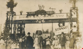
- Photographic postcard of the welcome arch erected at Edmonds and Kingsway to welcome Prince Arthur, Duke of Connaught during his visit to Burnaby. A large crowd is milling around the decorated arch which reads, "Burnaby Welcomes You." Prince Arthur was Governor General of Canada at this time.
- Repository
- City of Burnaby Archives
- Date
- 1912
- Collection/Fonds
- Burnaby Historical Society fonds
- Subseries
- Pioneer Tales subseries
- Physical Description
- 1 photograph : sepia postcard ; 8.9 x 14.0 cm
- Description Level
- Item
- Record No.
- 204-800
- Access Restriction
- No restrictions
- Reproduction Restriction
- No known restrictions
- Accession Number
- BHS1988-03
- Scope and Content
- Photographic postcard of the welcome arch erected at Edmonds and Kingsway to welcome Prince Arthur, Duke of Connaught during his visit to Burnaby. A large crowd is milling around the decorated arch which reads, "Burnaby Welcomes You." Prince Arthur was Governor General of Canada at this time.
- Subjects
- Persons - Crowds
- Events - Royal Visits
- Documentary Artifacts - Postcards
- Events - Visits of State
- Symbols - Flags
- Structures - Arches
- Media Type
- Photograph
- Geographic Access
- Edmonds Street
- Kingsway
- Historic Neighbourhood
- Edmonds (Historic Neighbourhood)
- Planning Study Area
- Richmond Park Area
Images


Centennial Pavilion
https://search.heritageburnaby.ca/link/archivedescription37407
- Repository
- City of Burnaby Archives
- Date
- 1970
- Collection/Fonds
- Burnaby Historical Society fonds
- Description Level
- Item
- Physical Description
- 1 photograph : col. postcard ; 9 x 14 cm
- Scope and Content
- Photographic postcard of the Centennial Pavilion located in Burnaby Mountain Park. The caption on the back of the postcard reads: "The Centennial Pavilion, located in Burnaby Mountain Park was built in 1958 to commemorate the centenary of the Province of British Columbia. Numerous view points on be…
- Repository
- City of Burnaby Archives
- Date
- 1970
- Collection/Fonds
- Burnaby Historical Society fonds
- Subseries
- Robert Prittie subseries
- Physical Description
- 1 photograph : col. postcard ; 9 x 14 cm
- Description Level
- Item
- Record No.
- 369-006
- Access Restriction
- No restrictions
- Reproduction Restriction
- Reproduce for fair dealing purposes only
- Accession Number
- BHS1999-01
- Scope and Content
- Photographic postcard of the Centennial Pavilion located in Burnaby Mountain Park. The caption on the back of the postcard reads: "The Centennial Pavilion, located in Burnaby Mountain Park was built in 1958 to commemorate the centenary of the Province of British Columbia. Numerous view points on beautifully landscaped grounds provide interesting panoramic views of the lower mainland."
- Media Type
- Photograph
- Photographer
- George Allen Aerial Photos Limited
- Notes
- Title based on caption
- Geographic Access
- Burnaby Mountain Conservation Area
- Centennial Way
- Street Address
- 100 Centennial Way
- Planning Study Area
- Burnaby Mountain Area
Images


Centennial Pavilion and Burnaby Mountain Park
https://search.heritageburnaby.ca/link/archivedescription37410
- Repository
- City of Burnaby Archives
- Date
- 1970
- Collection/Fonds
- Burnaby Historical Society fonds
- Description Level
- Item
- Physical Description
- 1 photograph : col. postcard ; 9 x 14 cm
- Scope and Content
- Photographic postcard of the rear portion of the Centennial Pavilion along with a view of some of the landscaping at Burnaby Mountain Park. The caption on the back of the photograph reads: "This park is situated on the western portion of Burnaby Mountain. Numerous view points throughout beautiful…
- Repository
- City of Burnaby Archives
- Date
- 1970
- Collection/Fonds
- Burnaby Historical Society fonds
- Subseries
- Robert Prittie subseries
- Physical Description
- 1 photograph : col. postcard ; 9 x 14 cm
- Description Level
- Item
- Record No.
- 369-009
- Access Restriction
- No restrictions
- Reproduction Restriction
- Reproduce for fair dealing purposes only
- Accession Number
- BHS1999-01
- Scope and Content
- Photographic postcard of the rear portion of the Centennial Pavilion along with a view of some of the landscaping at Burnaby Mountain Park. The caption on the back of the photograph reads: "This park is situated on the western portion of Burnaby Mountain. Numerous view points throughout beautifully landscaped grounds provide magnificent views of Burrard Inlet, Coast Range Mountains, City of Vancouver and surrounding Municipalities."
- Media Type
- Photograph
- Photographer
- George Allen Aerial Photos Limited
- Notes
- Title based on caption
- Geographic Access
- Burnaby Mountain Conservation Area
- Centennial Way
- Street Address
- 100 Centennial Way
- Planning Study Area
- Burnaby Mountain Area
Images


Central Park Entrance
https://search.heritageburnaby.ca/link/archivedescription38507
- Repository
- City of Burnaby Archives
- Date
- 1914
- Collection/Fonds
- Burnaby Historical Society fonds
- Description Level
- Item
- Physical Description
- 1 photograph : b&w postcard ; 9 x 14 cm
- Scope and Content
- Photographic postcard of the entrance arch at Central Park. The postcard was sent to R.M. Harding of Everett, Washington and bears a New Westminster postmark and is dated August 6, 1922. The note written on the reverse of the card reads: " Dear Ross, This is were [sic] we made camp tonight. Wish…
- Repository
- City of Burnaby Archives
- Date
- 1914
- Collection/Fonds
- Burnaby Historical Society fonds
- Subseries
- Photographs subseries
- Physical Description
- 1 photograph : b&w postcard ; 9 x 14 cm
- Description Level
- Item
- Record No.
- 449-002
- Access Restriction
- No restrictions
- Reproduction Restriction
- No known restrictions
- Accession Number
- BHS2007-04
- Scope and Content
- Photographic postcard of the entrance arch at Central Park. The postcard was sent to R.M. Harding of Everett, Washington and bears a New Westminster postmark and is dated August 6, 1922. The note written on the reverse of the card reads: " Dear Ross, This is were [sic] we made camp tonight. Wish you were with us. We have had a dandy trip so far - but awfully dusty for about 14 miles from this side of the border line. Love, Eva."
- Names
- Harding, Ross M.
- Media Type
- Photograph
- Notes
- Title based on contents of photograph.
- Geographic Access
- Central Park
- Imperial Street
- Street Address
- 3883 Imperial Street
- Historic Neighbourhood
- Central Park (Historic Neighbourhood)
- Planning Study Area
- Maywood Area
Images


Century Gardens
https://search.heritageburnaby.ca/link/archivedescription37402
- Repository
- City of Burnaby Archives
- Date
- 1970
- Collection/Fonds
- Burnaby Historical Society fonds
- Description Level
- Item
- Physical Description
- 1 photograph : col. postcard ; 9 x 14 cm
- Scope and Content
- Photographic postcard looking over the Century Gardens, towards the Ceperley House in Deer Lake. The caption on the reverse of the postcard reads: "Century Gardens was Burnaby's Centennial Project commemorating Canada's 100th birthday. The Corporation bought this mansion and its spacious grounds …
- Repository
- City of Burnaby Archives
- Date
- 1970
- Collection/Fonds
- Burnaby Historical Society fonds
- Subseries
- Robert Prittie subseries
- Physical Description
- 1 photograph : col. postcard ; 9 x 14 cm
- Description Level
- Item
- Record No.
- 369-001
- Access Restriction
- No restrictions
- Reproduction Restriction
- Reproduce for fair dealing purposes only
- Accession Number
- BHS1999-01
- Scope and Content
- Photographic postcard looking over the Century Gardens, towards the Ceperley House in Deer Lake. The caption on the reverse of the postcard reads: "Century Gardens was Burnaby's Centennial Project commemorating Canada's 100th birthday. The Corporation bought this mansion and its spacious grounds located on the north shore of Deer Lake. The building was restored and now operates as Burnaby's new Art Centre. The grounds were relandscaped and over 2000 rhododendrons, Burnaby's official flower, were planted to promote the numerous named varieties which can be grown in the lower mainland."
- Media Type
- Photograph
- Photographer
- George Allen Aerial Photos Limited
- Notes
- Title based on caption
- Geographic Access
- Deer Lake Avenue
- Street Address
- 6344 Deer Lake Avenue
- Historic Neighbourhood
- Burnaby Lake (Historic Neighbourhood)
- Planning Study Area
- Douglas-Gilpin Area
Images

![CPR Depot, Barnet, BC, [191-] thumbnail](/media/hpo/_Data/_Archives_Images/_Unrestricted/540/540-002.jpg?width=280)
CPR Depot, Barnet, BC
https://search.heritageburnaby.ca/link/archivedescription73594
- Repository
- City of Burnaby Archives
- Date
- [191-]
- Collection/Fonds
- LaFavor Family fonds
- Description Level
- Item
- Physical Description
- 1 photograph : sepia postcard ; 8.5 x 14 cm
- Scope and Content
- Photographic postcard depicting a train at the C.P.R. Depot in Barnet Village, Burnaby.
- Repository
- City of Burnaby Archives
- Date
- [191-]
- Collection/Fonds
- LaFavor Family fonds
- Physical Description
- 1 photograph : sepia postcard ; 8.5 x 14 cm
- Description Level
- Item
- Record No.
- 540-002
- Access Restriction
- No restrictions
- Reproduction Restriction
- No restrictions
- Accession Number
- 2007-03
- Scope and Content
- Photographic postcard depicting a train at the C.P.R. Depot in Barnet Village, Burnaby.
- Subjects
- Documentary Artifacts - Postcards
- Transportation - Rail
- Buildings - Commercial - Train Stations
- Media Type
- Photograph
- Photographer
- Canadian Photo Company
- Notes
- Transcribed title
- Geographic Access
- Barnet Village
- Barnet Road
- Street Address
- 8181 Barnet Road
- Historic Neighbourhood
- Barnet (Historic Neighbourhood)
- Planning Study Area
- Burnaby Mountain Area
Images
![CPR Depot, Barnet, BC, [191-] thumbnail](/media/hpo/_Data/_Archives_Images/_Unrestricted/540/540-002.jpg)
Crowd at Edmonds and Kingsway
https://search.heritageburnaby.ca/link/archivedescription35939
- Repository
- City of Burnaby Archives
- Date
- 1912
- Collection/Fonds
- Burnaby Historical Society fonds
- Description Level
- Item
- Physical Description
- 1 photograph : sepia postcard ; 8.9 x 14.0 cm
- Scope and Content
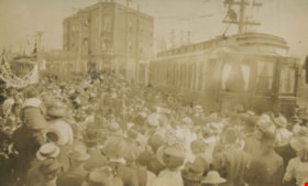
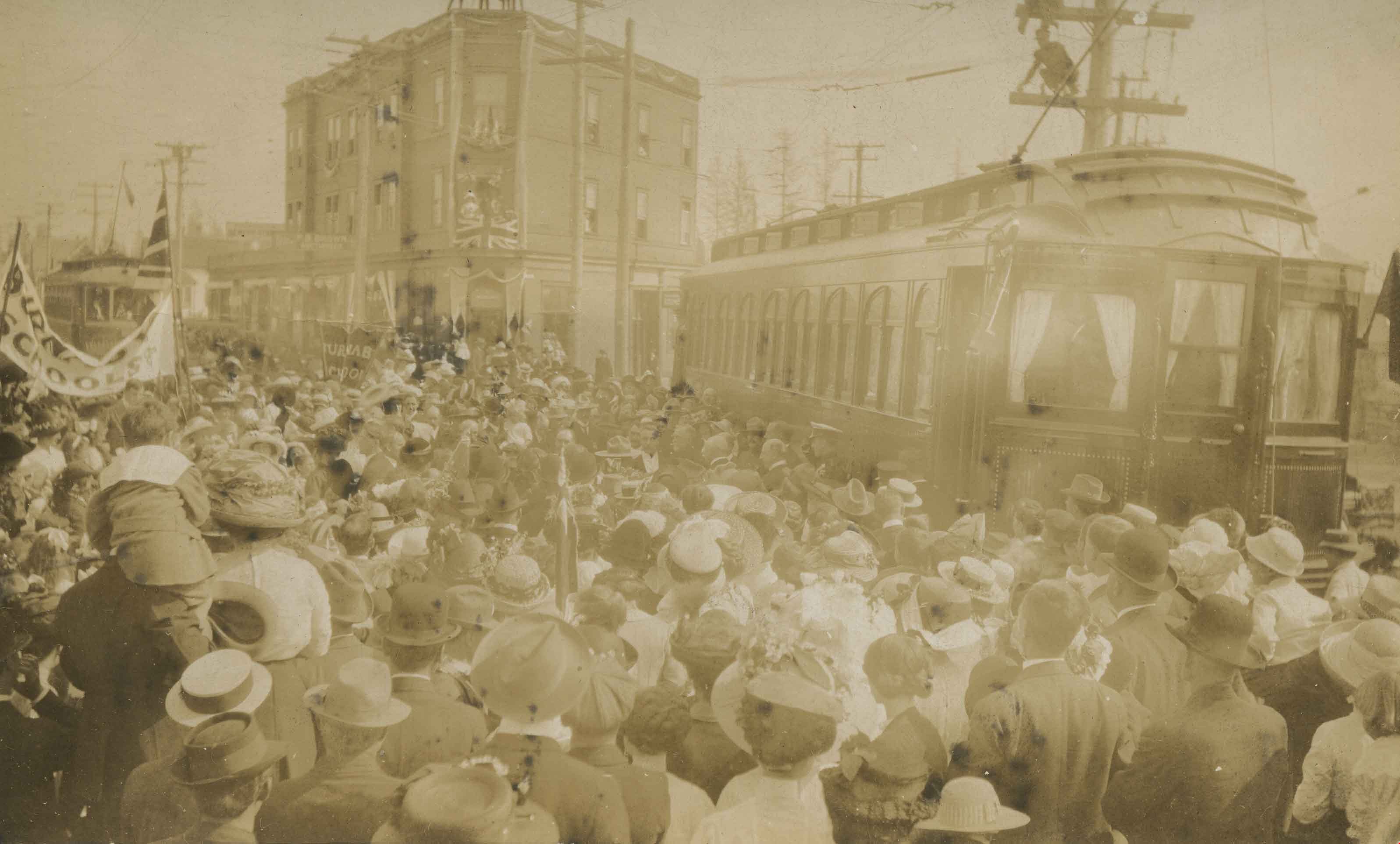
- Photographic postcard of a crowd gathered near a tram car at Edmonds and Kingsway during Prince Arthur, the Duke of Connaught's visit to Burnaby. A Union Jack is hanging from one of the windows of the triangular Edmonds Block, which is visible in the background. The Duke of Connaught was Governor G…
- Repository
- City of Burnaby Archives
- Date
- 1912
- Collection/Fonds
- Burnaby Historical Society fonds
- Subseries
- Pioneer Tales subseries
- Physical Description
- 1 photograph : sepia postcard ; 8.9 x 14.0 cm
- Description Level
- Item
- Record No.
- 204-799
- Access Restriction
- No restrictions
- Reproduction Restriction
- No known restrictions
- Accession Number
- BHS1988-03
- Scope and Content
- Photographic postcard of a crowd gathered near a tram car at Edmonds and Kingsway during Prince Arthur, the Duke of Connaught's visit to Burnaby. A Union Jack is hanging from one of the windows of the triangular Edmonds Block, which is visible in the background. The Duke of Connaught was Governor General of Canada at this time.
- Subjects
- Persons - Crowds
- Transportation - Electric Railroads
- Events - Royal Visits
- Documentary Artifacts - Postcards
- Events - Visits of State
- Media Type
- Photograph
- Notes
- Title based on contents of photograph
- Geographic Access
- Edmonds Street
- Kingsway
- Historic Neighbourhood
- Edmonds (Historic Neighbourhood)
- Planning Study Area
- Richmond Park Area
Images
![Douglas Road, Burnaby, [1908] thumbnail](/media/hpo/_Data/_Archives_Images/_Unrestricted/371/449-009.jpg?width=280)
Douglas Road, Burnaby
https://search.heritageburnaby.ca/link/archivedescription38514
- Repository
- City of Burnaby Archives
- Date
- [1908]
- Collection/Fonds
- Burnaby Historical Society fonds
- Description Level
- Item
- Physical Description
- 1 photograph : sepia postcard ; 8.8 x 14 cm
- Scope and Content
- Photographic postcard taken looking northwest along Douglas Road (now Canada Way) near Stanley Street. Two unidentified people are standing next to a wooden fence running alongside the road (above Lubbock's Creek) and a number of houses (including the Sprott house) are visible in the background. To…
- Repository
- City of Burnaby Archives
- Date
- [1908]
- Collection/Fonds
- Burnaby Historical Society fonds
- Subseries
- Photographs subseries
- Physical Description
- 1 photograph : sepia postcard ; 8.8 x 14 cm
- Description Level
- Item
- Record No.
- 449-009
- Access Restriction
- No restrictions
- Reproduction Restriction
- No known restrictions
- Accession Number
- BHS2007-04
- Scope and Content
- Photographic postcard taken looking northwest along Douglas Road (now Canada Way) near Stanley Street. Two unidentified people are standing next to a wooden fence running alongside the road (above Lubbock's Creek) and a number of houses (including the Sprott house) are visible in the background. To the right is Burnaby Lake. Stamped at the top of the postcard is "Douglas Road, Burnaby / New Westminster BC."
- Subjects
- Geographic Features - Lakes and Ponds
- Documentary Artifacts - Postcards
- Geographic Features - Roads
- Media Type
- Photograph
- Geographic Access
- Douglas Road
- Stanley Street
- Canada Way
- Deer Lake
- Historic Neighbourhood
- Burnaby Lake (Historic Neighbourhood)
- Planning Study Area
- Lakeview-Mayfield Area
Images
![Douglas Road, Burnaby, [1908] thumbnail](/media/hpo/_Data/_Archives_Images/_Unrestricted/371/449-009.jpg)

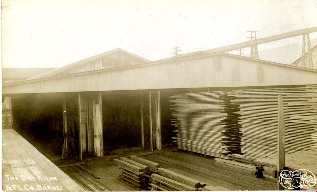
The Dry Kilns
https://search.heritageburnaby.ca/link/archivedescription73600
- Repository
- City of Burnaby Archives
- Date
- 1912
- Collection/Fonds
- LaFavor Family fonds
- Description Level
- Item
- Physical Description
- 1 photograph : sepia postcard ; 8.5 x 14 cm
- Scope and Content
- Photographic postcard of the dry kilns at the North Pacific Lumber Company in Barnet Village, BC.
- Repository
- City of Burnaby Archives
- Date
- 1912
- Collection/Fonds
- LaFavor Family fonds
- Physical Description
- 1 photograph : sepia postcard ; 8.5 x 14 cm
- Description Level
- Item
- Record No.
- 540-008
- Access Restriction
- No restrictions
- Reproduction Restriction
- No known restrictions
- Accession Number
- 2007-03
- Scope and Content
- Photographic postcard of the dry kilns at the North Pacific Lumber Company in Barnet Village, BC.
- Subjects
- Documentary Artifacts - Postcards
- Industries - Logging/lumber
- Industries - Forestry
- Buildings - Industrial - Mills
- Names
- Barnet Mill
- Media Type
- Photograph
- Photographer
- Canadian Photo Company
- Notes
- Transcribed title
- Geographic Access
- Barnet Village
- Texaco Drive
- Street Address
- 8059 Texaco Drive
- Historic Neighbourhood
- Barnet (Historic Neighbourhood)
- Planning Study Area
- Burnaby Mountain Area
Images
![East Burnaby Public School, [1911 or 1912] (date of original), copied 1985 thumbnail](/media/hpo/_Data/_Archives_Images/_Unrestricted/126/140-008.jpg?width=280)
East Burnaby Public School
https://search.heritageburnaby.ca/link/archivedescription34827
- Repository
- City of Burnaby Archives
- Date
- [1911 or 1912] (date of original), copied 1985
- Collection/Fonds
- Burnaby Historical Society fonds
- Description Level
- Item
- Physical Description
- 1 photograph : b&w postcard ; 8.8 x 13.9 cm
- Scope and Content
- Photographic postcard of a class at Edmonds Street School. Stamped at top of postcard: "East, Burnaby. / Public School." Stamped at bottom of postcard, "W. Brown, Photo." Front row, left to right: George Gregson, [unidentified], and George Powys. Second row, left to right: Phyllis Brown, Hazel A…
- Repository
- City of Burnaby Archives
- Date
- [1911 or 1912] (date of original), copied 1985
- Collection/Fonds
- Burnaby Historical Society fonds
- Subseries
- Lewis family subseries
- Physical Description
- 1 photograph : b&w postcard ; 8.8 x 13.9 cm
- Description Level
- Item
- Record No.
- 140-008
- Access Restriction
- No restrictions
- Reproduction Restriction
- No known restrictions
- Accession Number
- BHS1985-10
- Scope and Content
- Photographic postcard of a class at Edmonds Street School. Stamped at top of postcard: "East, Burnaby. / Public School." Stamped at bottom of postcard, "W. Brown, Photo." Front row, left to right: George Gregson, [unidentified], and George Powys. Second row, left to right: Phyllis Brown, Hazel Allen, Etta Bonsor, Mary Buchanan, Jane Allen, Lila Skelly, and Eileen Jordan. Third row (girls standing), left to right: Margaret Stride, Lucy Jackson, Esther Love, Grace Morrison, Lillie Lewis, Anna Doole, and Lillie Vernon. Back row (boys standing), left to right: Burnie Feedham, [unidentified], Leonard Ettinger, Edward Clayton, and Mr. Lowther (teacher).
- Names
- Allen, Hazel
- Allen, Jane
- Bonsor, Etta
- Brown, Phyllis
- Buchanan, Mary
- Clayton, Edward
- Doole, Anna
- East Burnaby School
- Edmonds Community School
- Ettinger, Leonard
- Feedham, Colonel Burnaby "Burnie"
- Gregson, George
- Jackson, Lucy
- Jordan, Eileen
- Morrison, Grace
- Porter, Lillie Lewis
- Powys, George
- Skelly, Lila
- Stanley, Esther Love
- Stride, Margaret
- Vernon, Lillie
- Media Type
- Photograph
- Photographer
- Brown, W.
- Notes
- Title based on contents of photograph
- Geographic Access
- Edmonds Street
- Street Address
- 7641 Edmonds Street
- Historic Neighbourhood
- Edmonds (Historic Neighbourhood)
- Planning Study Area
- Edmonds Area
Images
![East Burnaby Public School, [1911 or 1912] (date of original), copied 1985 thumbnail](/media/hpo/_Data/_Archives_Images/_Unrestricted/126/140-008.jpg)
![The Fair Haven, [between 1950 and 1957] thumbnail](/media/Hpo/_Data/_Archives_Images/_Unrestricted/251/305-001.jpg?width=280)
The Fair Haven
https://search.heritageburnaby.ca/link/archivedescription36597
- Repository
- City of Burnaby Archives
- Date
- [between 1950 and 1957]
- Collection/Fonds
- Burnaby Historical Society fonds
- Description Level
- Item
- Physical Description
- 1 photograph : col. postcard ; 9 x 14 cm
- Scope and Content
- Aerial photographic postcard of "the Fair Haven," a group of United Church homes for Senior Citizens. The road in the foreground is Rumble Street, and the long road to the right is Sussex Avenue. The small forest behind "the Fair Haven" is the David Gary Park.
- Repository
- City of Burnaby Archives
- Date
- [between 1950 and 1957]
- Collection/Fonds
- Burnaby Historical Society fonds
- Subseries
- Vera Jackson Pel subseries
- Physical Description
- 1 photograph : col. postcard ; 9 x 14 cm
- Description Level
- Item
- Record No.
- 305-001
- Access Restriction
- No restrictions
- Reproduction Restriction
- Reproduce for fair dealing purposes only
- Accession Number
- BHS1992-46
- Scope and Content
- Aerial photographic postcard of "the Fair Haven," a group of United Church homes for Senior Citizens. The road in the foreground is Rumble Street, and the long road to the right is Sussex Avenue. The small forest behind "the Fair Haven" is the David Gary Park.
- Subjects
- Aerial Photographs
- Documentary Artifacts - Postcards
- Buildings - Residential - Seniors Housing
- Names
- Fair Haven
- Media Type
- Photograph
- Notes
- Typewritten note on verso of postcard reads: "AERIAL VIEW/ 'The Fairhaven', Burnaby BC / United Church Homes for Senior Citizens / 4341 Rumble St., Burnaby, BC"
- Handwritten note on verso of postcard reads: ""The road in the foreground is Rumble Street. The long road to the right is Sussex Avenue. The road, going up, on the left, barely visible is McKay Avenue = lower corner. Behind Fair Haven is the future David Gary Park cleared in the late 1950's - then more trees were felled in October 1962 with Hurricane Freda (blown over, uprooted trees) that left the park as it is today in 1993. The top row of little (5) white cottages were moved from the N.W. corner of Willingdon and Kingsway where Old Orchard Mall is now - they were part of Old Orchard Auto Villas, the first Fair Havens. Note: All cottages on right side of Lodge have been moved to Vancouver Island in 1991 for Motel units - by barge."
- Printed on verso of postcard: "Traveltime product, made in Vancouver, Canada, by Grant-Mann Lithographers Ltd."
- Geographic Access
- Rumble Street
- Street Address
- 4341 Rumble Street
- Historic Neighbourhood
- Alta-Vista (Historic Neighbourhood)
- Planning Study Area
- Sussex-Nelson Area
Images
![The Fair Haven, [between 1950 and 1957] thumbnail](/media/Hpo/_Data/_Archives_Images/_Unrestricted/251/305-001.jpg)