Narrow Results By
Decade
- 2020s 132
- 2010s 197
- 2000s 337
- 1990s 353
- 1980s 391
- 1970s 653
- 1960s 488
- 1950s 545
- 1940s 368
- 1930s
- 1920s 693
- 1910s 356
- 1900s 93
- 1890s 43
- 1880s 5
- 1870s 4
- 1860s 5
- 1850s 2
- 1840s 1
- 1830s 1
- 1820s 1
- 1810s 1
- 1800s 2
- 1790s 1
- 1780s 1
- 1770s 1
- 1760s 1
- 1750s 1
- 1740s 1
- 1730s 1
- 1720s 1
- 1710s 1
- 1700s 1
- 1690s 1
- 1680s 1
- 1670s 1
- 1660s 1
- 1650s 1
- 1640s 1
- 1630s 1
- 1620s 1
- 1610s 1
- 1600s 1
Subject
- Agriculture - Farms 1
- Animals - Dogs 1
- Animals - Horses 1
- Buildings - Civic - Libraries 1
- Buildings - Commercial - Grocery Stores 5
- Buildings - Commercial - Hotels and Motels 9
- Buildings - Commercial - Theatres 1
- Buildings - Heritage 3
- Buildings - Industrial 1
- Buildings - Industrial - Factories 1
- Buildings - Industrial - Mills 2
- Buildings - Industrial - Saw Mills 1
Person / Organization
- Bayntun, Charmaine "Sherrie" Yanko 2
- Bingham, Alfred "Alf" 18
- Bradbury, Dr. Bettina 36
- Burnaby Central Secondary School 1
- Burnaby City Hall 1
- Burnaby Lawn Bowling Club 1
- Burnaby Monumental Works 1
- Burnaby Village Museum 1
- Burrell, Beverley "Bev" Lewarne 1
- City of Burnaby 1
- Codd, Lisa 1
- Damer, Eric 2

Hans & Anna Hau Residence
https://search.heritageburnaby.ca/link/landmark588
- Repository
- Burnaby Heritage Planning
- Description
- Residential building.
- Associated Dates
- c.1935
- Street View URL
- Google Maps Street View
- Repository
- Burnaby Heritage Planning
- Geographic Access
- Canada Way
- Associated Dates
- c.1935
- Description
- Residential building.
- Heritage Value
- Danish builder Hans Jorgensen Hau (1878-1944) and his wife Anna (née Sorenson, 1874-1956), constructed this highly-distinctive Tudor Revival residence circa 1935. This was a time of entrenched traditionalism, and most domestic architecture reflected period revival styles. Tudor elements have been compressed here into a cottage form, including a distinctive front façade with half timbering and brick noggin; on the sides the nogging is rock-dash stucco. Casement windows contribute to the cottage appearance. The rear façade is clad with more utilitarian shingles. A prominent brick chimney exhibits angled and corbelled brickwork. Hau worked as a bricklayer and stonemason, and this house has common elements with the Moore Residence at 5165 Sperling Avenue, which Hau designed and constructed in 1943.
- Locality
- Burnaby Lake
- Historic Neighbourhood
- Burnaby Lake (Historic Neighbourhood)
- Planning Study Area
- Morley-Buckingham Area
- Area
- 2010.52
- Contributing Resource
- Building
- Ownership
- Private
- Street Address
- 5070 Canada Way
- Street View URL
- Google Maps Street View
Images


Mary Sutcliffe Residence
https://search.heritageburnaby.ca/link/landmark621
- Repository
- Burnaby Heritage Planning
- Description
- Residential building.
- Associated Dates
- c.1930
- Street View URL
- Google Maps Street View
- Repository
- Burnaby Heritage Planning
- Geographic Access
- Boundary Road North
- Associated Dates
- c.1930
- Description
- Residential building.
- Heritage Value
- Built at a time when historical styles were favoured for domestic construction, this charming cottage residence was built for Mary Seymour Sutcliffe (1870-1959), the wife of retired painter Arthur Sutcliffe (1863-1932). It was inspired by the British Arts and Crafts movement, as displayed in the half-timbering, rounded door hood and the picturesque, jerkin-headed roof with exposed purlins. While this house has a Boundary Road address, the house faces north instead of west, facing an elevated and extraordinary view of Burrard Inlet.
- Locality
- Vancouver Heights
- Historic Neighbourhood
- Vancouver Heights (Historic Neighbourhood)
- Planning Study Area
- Burnaby Heights Area
- Area
- 566.71
- Contributing Resource
- Building
- Ownership
- Private
- Street Address
- 650 Boundary Road North
- Street View URL
- Google Maps Street View
Images


Brentwood Neighbourhood
https://search.heritageburnaby.ca/link/landmark669
- Repository
- Burnaby Heritage Planning
- Associated Dates
- 1925-1954
- Heritage Value
- In July, 1953, Burnaby's Municipal Council gave approval for the construction of a $12,000,000 residential and shopping development to be called Brentwood Park, located on the northeast corner of Lougheed and Willingdon. Plans called for about 400 homes and a 30-acre shopping centre to be built in this new subdivision - the first large residential subdivision in Burnaby to be developed with sewers and paved streets as well as other services.
- Planning Study Area
- Brentwood Area
Images


Burnaby Lake Neighbourhood
https://search.heritageburnaby.ca/link/landmark700
- Repository
- Burnaby Heritage Planning
- Associated Dates
- 1925-1954
- Heritage Value
- After World War I and the Great Depression of the 1930s, more homes were constructed and subdivisions created in the Burnaby Lake district. The area around Deer Lake gained a reputation for being an "artistic development of commodious homes with park-like grounds."
- Historic Neighbourhood
- Burnaby Lake (Historic Neighbourhood)
- Planning Study Area
- Burnaby Lake Area
Images


Lozells Neighbourhood
https://search.heritageburnaby.ca/link/landmark701
- Repository
- Burnaby Heritage Planning
- Associated Dates
- 1925-1954
- Heritage Value
- Like a lot of residential neighbourhoods in Burnaby during the post-War boom, the Lozells area during the 1925-1954 period was one of new construction and subdivisions. Although more homes were being built, the neighbourhood still retained a somewhat rural characteristic well into the 1950s.
- Historic Neighbourhood
- Lozells (Historic Neighbourhood)
- Planning Study Area
- Government Road Area
Images


Edmonds Neighbourhood
https://search.heritageburnaby.ca/link/landmark704
- Repository
- Burnaby Heritage Planning
- Associated Dates
- 1925-1954
- Heritage Value
- The historic growth of Edmonds as a neighbourhood was based on its strategic location on the early interurban line between Vancouver and New Westminster. Even by 1980 when a survey of the residential neighbourhoods was conducted, a full 25% of homes in the area predated 1930. The 1950s was a period of strong housing development, with both single-family and multi-family units being constructed. Although Burnaby's City Hall was moved from Kingsway and Edmonds in the early 1950s, Edmonds remained an important centre in the community.
- Historic Neighbourhood
- Edmonds (Historic Neighbourhood)
- Planning Study Area
- Stride Avenue Area
Images


Alta Vista Neighbourhood
https://search.heritageburnaby.ca/link/landmark707
- Repository
- Burnaby Heritage Planning
- Associated Dates
- 1925-1954
- Heritage Value
- As with many areas of Burnaby during this period, the years after World War Two marked a rapid growth in residential development in the Alta-Vista Neighbourhood. Subdivisions like Sussex and Suncrest were built and new schools and amenities were constructed to meet the demands of increased population.
- Historic Neighbourhood
- Alta Vista (Historic Neighbourhood)
- Planning Study Area
- Sussex-Nelson Area
Images


East Burnaby Neighbourhood
https://search.heritageburnaby.ca/link/landmark712
- Repository
- Burnaby Heritage Planning
- Associated Dates
- 1925-1954
- Heritage Value
- After a lull in construction during the World War I period, East Burnaby Neighbourhood's growth resumed during the 1920s when many homes and businesses were constructed. The post-World War Two period also saw rapid construction and the creation of new housing developments in response to a population boom. The neighbourhood remained a primarily single-family residential area.
- Historic Neighbourhood
- Edmonds (Historic Neighbourhood)
- Planning Study Area
- Stride Avenue Area
Images


Burnaby North High School
https://search.heritageburnaby.ca/link/landmark745
- Repository
- Burnaby Heritage Planning
- Associated Dates
- 1923-1982
- Street View URL
- Google Maps Street View
- Repository
- Burnaby Heritage Planning
- Geographic Access
- Willingdon Avenue
- Associated Dates
- 1923-1982
- Heritage Value
- Burnaby North and Burnaby South were the first high schools built in the City. Before the high school opened, Burnaby students had to travel to Vancouver if they wished to pursue education beyond an elementary level. In 1921, arrangements were made to use the basement of the Presbyterian Church for instruction of local students. By 1922 the Burnaby North High School opened at its first permanent location (4375 Pandora Street - which is now Rosser Elementary). In 1945, the Willingdon Avenue site was built and was used until a new building was constructed in 1961 on Hammarskjold Drive. From 1962, the school was used as Burnaby Heights Junior High school, but it closed in 1982 and the junior high students went to the new Burnaby North on Hammarskjold.
- Historic Neighbourhood
- Capitol Hill (Historic Neighbourhood)
- Planning Study Area
- Capitol Hill Area
- Street Address
- 250 Willingdon Avenue
- Street View URL
- Google Maps Street View
Images

Audels carpenters and builders guide no. 4 : a practical illustrated trade assistant on modern construction for carpenters, joiners, builders, mechanics and all wood workers
https://search.heritageburnaby.ca/link/museumlibrary4837
- Repository
- Burnaby Village Museum
- Collection
- Special Collection
- Material Type
- Book
- Accession Code
- BV011.7.4
- Call Number
- 693 GRA
- Place of Publication
- New York
- Publisher
- Audel
- Publication Date
- c1939
- Physical Description
- xvi, 1089-1546 : ill. ; 17 cm.
- Inscription
- "NIXON'S / NEW WESTMINSTER B.C.", printed sticker inside back cover, bottom edge near spine
- Library Subject (LOC)
- Carpentry--Handbooks, manuals, etc.
- Building--Handbooks, manuals, etc.
- Object History
- Book was the property of George Love and used by him
- Notes
- "explaining in practical, concise language and by well done illustrations, diagrams, charts, graphs and pictures, principles, advances, short cuts-based on modern practice - including instructions on how to figure and calculate various jobs" --T.p.
Eclipse tempting recipes
https://search.heritageburnaby.ca/link/museumlibrary7432
- Repository
- Burnaby Village Museum
- Author
- Riley, Dickson
- Publication Date
- c1931
- Call Number
- 641.59 RIL
- Repository
- Burnaby Village Museum
- Collection
- Special Collection
- Material Type
- Textual Record
- Accession Code
- BV019.37.3
- Call Number
- 641.59 RIL
- Author
- Riley, Dickson
- Place of Publication
- Winnipeg, [Manitoba]
- Publisher
- Western Pure Foods Ltd.
- Publication Date
- c1931
- Physical Description
- 32 pages : ill.; 18 cm.
- Inscription
- Handwritten text on front cover reads: "Mrs. EW Martin".
- Library Subject (LOC)
- Cooking, Canadian
- Cooking
- Desserts
- Cake
- Cookies
- Cookbooks--1930-1939
- Object History
- Elmer Wilson Martin was a professional engineer who lived much of his life in Burnaby. He married Ellen Renetta "Reta" (Boyd) Martin in approx. 1930 and the couple moved to Burnaby in 1931 for him to attend UBC. He later enlisted in the RCAF during WWII where he served as a pilot and wing commander. Elmer ran Martin's Auto Villa at 6604 East Hastings Street (later 6574 East Hastings Street) and was heavily involved in local Burnaby politics and with the North Burnaby Board of Trade. The donor states that he ran for Burnaby mayor in 1959 and also donated land to S.F.U. in the late 1960's. He had many businesses throughout his life including Paneloc Buildings, a pre-fab building manufacturing company. His last position was as Director with the construction company Webb & Knapp Canada Ltd.

Interview with Dr Blythe Eagles and Dr Violet Eagles 10-Jun-75 - Track 9
https://search.heritageburnaby.ca/link/oralhistory49
- Repository
- City of Burnaby Archives
- Date Range
- 1939-1945
- Length
- 0:10:53
- Summary
- This portion of the interview pertains to Dr Blythe Alfred Eagles and Dr Violet Evelyn (Dunbar) Eagles' memories of activities they were involved in during the war years, including Red Cross Garden Parties and how different this time was from the days of the Depression.
- Repository
- City of Burnaby Archives
- Summary
- This portion of the interview pertains to Dr Blythe Alfred Eagles and Dr Violet Evelyn (Dunbar) Eagles' memories of activities they were involved in during the war years, including Red Cross Garden Parties and how different this time was from the days of the Depression.
- Date Range
- 1939-1945
- Photo Info
- Mrs. Dunbar, Dr. Blythe Eagles and Dr. Violet (Dunbar) Eagles, June 1967. Item no. 404-002
- Length
- 0:10:53
- Names
- Red Cross
- Subjects
- Wars - World War, 1939-1945
- Interviewer
- Bradbury, Dr. Bettina
- Interview Date
- 10-Jun-75
- Scope and Content
- Recording is a taped interview with Dr Blythe Eagles and his wife Dr Violet Eagles by SFU (Simon Fraser University) graduate student Bettina Bradbury (and Ross S. McLeod) June 10, 1975. Major themes discussed are: the Depression, the War Years and Burnaby Lake District. To view "Narrow By" terms for each track expand this description and see "Notes".
- Biographical Notes
- Blythe's paternal grandparents, Charles and Maude Eagles immigrated to New Westminster in 1887. Their son Jack married Amelia Jane Johnston, and Blythe Eagles was born in New Westminster in 1902. In 1918 Blythe enrolled at the University of British Columbia, and took a Physiology class with eight other top students - his future wife, Violet Dunbar was the lone woman in the class. Blythe graduated in 1922, winning the Governor General's Gold Medal as top student. He received his MA in 1924 and his PhD in 1926 from the University of Toronto. He then completed his post-doctoral study at the National Institute for Medical Research in London, England. In 1933 Dr. Eagles became head of the Department of Dairying (1936-1955), Chairman of the Division of Animal Science (1955-1967), and Dean of the Faculty of Agriculture (in 1949 until his retirement in 1967). In 1968 he received an Honourary Doctor of Science Award from UBC Blythe was also one of the first appointments to the Burnaby Town Planning Commission. Violet Evelyn Dunbar was born September 29, 1899 in Ontario, the eldest child of John and Mary (Tompson) Dunbar. Violet attained her BA in 1921 and MA in 1922 from the University of British Columbia. In 1922 she attended the Provincial Normal School and within six months had a teaching certificate and taught at Lord Hudson School in 1923. In September 1923 she was awarded a two-year scholarship to the University of Toronto, where she joined Blythe in the Bio-Chemistry Department. She received a second MA and a PhD in 1929. Her graduate studies entailed research in pure proteins and enzymes related to the commercial production of cheese. Through this work she was recognized as one of the leading enzyme chemists in the country, being a senior lab instructor of biochemistry. Violet was one of the founders of the Burnaby Council of Women and active member of the International Council of Women. Blythe and Violet Eagles purchased property at Deer Lake in 1929 and began construction of their home shortly before their marriage on June 25, 1930. The Drs. Blythe and Violet Eagles Estate is a unique expression of the talents and tastes of both the Eagles and Frank Ebenezer Buck (1875-1970) who was head of the Horticultural Department and the Campus Landscape Architect at U.B.C. and established the plan for the Eagles garden while Blythe selected many of the plantings. The Eagles themselves designed the house as a romantic cottage inspired by the British Arts and Crafts style. Violet was an enthusiastic amateur gardener, maintaining and continually developing the garden. The Eagles were active volunteers in the local community as well as at UBC. When Simon Fraser University opened in Burnaby, they became well-known for entertaining dignitaries and special guests of the university in their lavish garden. After Violet's death in 1993, the estate was sold to the City of Burnaby. The funds were used to establish a Chair in Agriculture at the University of British Columbia in their memory.
- Total Tracks
- 11
- Total Length
- 1:24:01
- Interviewee Name
- Eagles, Dr. Blythe
- Eagles, Dr. Violet
- Interviewer Bio
- Bettina Bradbury teaches history and women's studies at York University. She is the author of Wife to Widow. Lives, Laws and Politics in Nineteenth-century Montreal. (Vancouver: University of British Columbia Press, June 2011), 520p; Working Families. Age, Gender and Daily Survival in Industrializing Montreal. (Toronto: Canadian Social History Series, McClelland and Stewart, 1993); (Republished Toronto: Oxford University Press, 1996) (3rd edition, Toronto: University of Toronto Press, 2007). These interviews were undertaken after she completed her MA at Simon Fraser University in 1975 with the support of an LIP grant.
- Collection/Fonds
- Burnaby Historical Society fonds
- Subseries
- Oral history subseries
- Media Type
- Sound Recording
- Web Notes
- Interview was digitized in 2010 allowing it to be accessible on Heritage Burnaby. The digitization project was initiated by the Community Heritage Commission with support from City of Burnaby Council and the BC History Digitization Program of the Irving K. Barber Learning Centre, University of British Columbia. It was recognized by the Heritage Society of BC with an award in 2012.
Images

Audio Tracks
Track nine of interview with Dr Blythe Eagles and Dr Violet Eagles
Track nine of interview with Dr Blythe Eagles and Dr Violet Eagles
https://search.heritageburnaby.ca/media/hpo/_Data/_Archives_Oral_Histories/_Unrestricted/100-13-08/100-13-08_Track_9.mp3
Jubilee Grove Arch
https://search.heritageburnaby.ca/link/landmark533
- Repository
- Burnaby Heritage Planning
- Description
- The Jubilee Grove Arch sits at the corner of Kingsway and Patterson Avenue. Located within Central Park, the ceremonial arch and its decorative plantings provide a visual anchor to the northeast corner and entry point to the park.
- Associated Dates
- 1939
- Formal Recognition
- Heritage Designation, Community Heritage Register
- Street View URL
- Google Maps Street View
- Repository
- Burnaby Heritage Planning
- Geographic Access
- Imperial Street
- Associated Dates
- 1939
- Formal Recognition
- Heritage Designation, Community Heritage Register
- Enactment Type
- Bylaw No. 9807
- Enactment Date
- 23/11/1992
- Description
- The Jubilee Grove Arch sits at the corner of Kingsway and Patterson Avenue. Located within Central Park, the ceremonial arch and its decorative plantings provide a visual anchor to the northeast corner and entry point to the park.
- Heritage Value
- Jubilee Grove Arch was dedicated as part of the municipality’s celebration of the Jubilee of the coronation of King George V and was dedicated during Burnaby’s annual May Day celebrations in 1935. Much of the construction work was carried out by local citizens under the direction of the Burnaby Engineering Department through a Depression era work relief program that provided a way for local residents to pay their taxes. The garden was also chosen as the site for the ceremonial planting of an oak tree from the Royal Forest at Windsor, in honor of the Coronation of King George VI and Queen Elizabeth in 1937. The original bronze garden dedication plaque and oak tree remain at the site today. The decorative stone arch was erected in 1939 as a symbol of Burnaby's, and the Lower Mainland of British Columbia’s, strong ties to the English monarchy at the time, and the arch’s unveiling during May Day ceremonies shows the social role that such a commemorative feature played both to the local government and people of Burnaby. It was erected just prior to the Royal Visit of 1939, the first time that reigning British monarchs had travelled to Canada. Built of Haddington Island sandstone, the arch itself was reconstructed from a salvaged architectural element of a historic Vancouver landmark. The arch originally framed the entrance door to the Vancouver Club building in Vancouver, built in 1893-94 on West Hastings Street and designed by architect C.O. Wickenden. The building was demolished in 1930, however the arch was stored and rebuilt as the focal point of the Jubilee Grove after being bought by the Municipality of Burnaby. The work was undertaken by Italian-born stone mason Rizieri Stefanini (1879-1954), the owner of Burnaby Monumental Works. The re-use of the arch symbolizes the close tie between Vancouver and Burnaby and the joint evolution of the neighbouring cities.
- Defining Elements
- The Jubilee Grove Arch has character-defining elements that recognize it both as a remnant of a past building and as a new and individual structure. These include its: - axial diagonal placement and prominent corner location marking one of the entries to Central Park - visibility and accessibility as a public monument - hand carved stone blocks of Haddington Island sandstone - decorative twisted-rope motif carved to outline the arch - supporting rusticated sidewalls with planting urns - original bronze dedication plaque - flanking ornamental gardens - Royal Oak tree and plaque
- Historic Neighbourhood
- Central Park (Historic Neighbourhood)
- Planning Study Area
- Maywood Area
- Organization
- City of Burnaby
- Architect
- C.O. Wickenden
- Function
- Primary Current--Park Fixture
- Primary Historic--Park Fixture
- Community
- Burnaby
- Cadastral Identifier
- P.I.D. No. 017-767-172 Legal Description: Block B of Lot 2 Except Firstly: Part on Plan 8669 and Secondly: Part on Plan LMP4689 District Lot 151, Group 1, New Westminster District, Plan 3443
- Boundaries
- The property (Central Park) is a municipally-owned park that lies at the western edge of Burnaby, between 49th Avenue to the south, Kingsway to the north, Boundary Road to the west and Patterson Avenue to the east.
- Area
- 853,403.82
- Contributing Resource
- Structure
- Landscape Feature
- Ownership
- Public (local)
- Documentation
- Heritage Site Files: PC77000 20. City of Burnaby Planning and Building Department, 4949 Canada Way, Burnaby, B.C., V5G 1M2
- Names
- Burnaby Monumental Works
- Street Address
- 3883 Imperial Street
- Street View URL
- Google Maps Street View
Images


![Yerba Buena to Oakland, [1939] thumbnail](/media/hpo/_Data/_BVM_Images/1985/1985_6114_0128_001.jpg?width=280)
Yerba Buena to Oakland
https://search.heritageburnaby.ca/link/museumdescription1734
- Repository
- Burnaby Village Museum
- Date
- [1939]
- Collection/Fonds
- Burnaby Village Museum Photograph collection
- Description Level
- Item
- Physical Description
- 1 photograph : b&w ; 5.5 x 8 cm
- Scope and Content
- Photograph of the original Eastern span of San Francisco-Oakland Bay Bridge (built in 1936) taken from Treasure Island. The bridge was constructed in five phases: first the East Span, followed by the tunnel through Yerba Buena Island, and then the West span. This was followed by the I-80 West Appro…
- Repository
- Burnaby Village Museum
- Collection/Fonds
- Burnaby Village Museum Photograph collection
- Description Level
- Item
- Physical Description
- 1 photograph : b&w ; 5.5 x 8 cm
- Scope and Content
- Photograph of the original Eastern span of San Francisco-Oakland Bay Bridge (built in 1936) taken from Treasure Island. The bridge was constructed in five phases: first the East Span, followed by the tunnel through Yerba Buena Island, and then the West span. This was followed by the I-80 West Approach and on- and off-ramps, and finally, the Transbay Terminal in San Francisco.
- Accession Code
- BV985.6114.128
- Access Restriction
- No restrictions
- Reproduction Restriction
- No known restrictions
- Date
- [1939]
- Media Type
- Photograph
- Scan Resolution
- 600
- Scan Date
- 2024-04-02
- Notes
- Title based on note written on verso of photograph
- Handwritten note in black ball-point pen on verso of photograph reads: "Yerba Beuna to Oakland"
- Stamp on verso of photograph reads: "653 F"
- Handwritten note in pencil on verso of photograph crosses out "53" and reads: "41"
Images
![Yerba Buena to Oakland, [1939] thumbnail](/media/hpo/_Data/_BVM_Images/1985/1985_6114_0128_001.jpg)
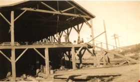
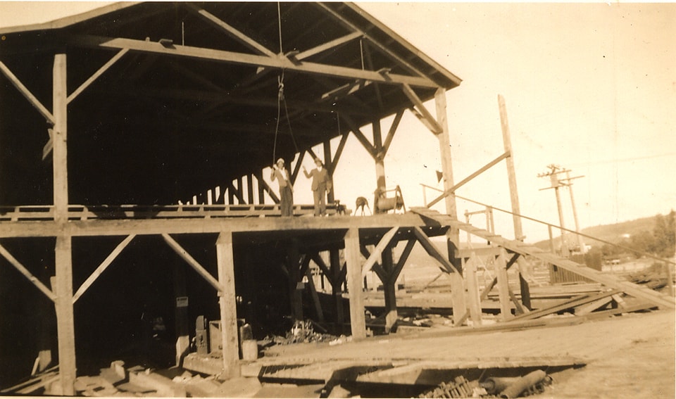
Kapoor sawmill being rebuilt
https://search.heritageburnaby.ca/link/museumdescription15186
- Repository
- Burnaby Village Museum
- Date
- 6 Aug. 1939 (date of original), copied 2004
- Collection/Fonds
- In the Shadow by the Sea collection
- Description Level
- Item
- Physical Description
- 1 photograph (tiff) : 300 dpi
- Scope and Content
- Photograph of Kapoor Sawmill being rebuilt in August 1939. Two unidentified men are standing on the second floor of the building under a block and tackle that is suspended from the beam above.
- Repository
- Burnaby Village Museum
- Collection/Fonds
- In the Shadow by the Sea collection
- Description Level
- Item
- Physical Description
- 1 photograph (tiff) : 300 dpi
- Scope and Content
- Photograph of Kapoor Sawmill being rebuilt in August 1939. Two unidentified men are standing on the second floor of the building under a block and tackle that is suspended from the beam above.
- Names
- Kapoor Sawmills Limited
- Accession Code
- BV019.32.7
- Access Restriction
- No restrictions
- Reproduction Restriction
- May be restricted by third party rights
- Date
- 6 Aug. 1939 (date of original), copied 2004
- Media Type
- Photograph
- Historic Neighbourhood
- Barnet (Historic Neighbourhood)
- Planning Study Area
- Burnaby Mountain Area
- Notes
- Title based on contents of photograph
Images
Request for Construction of Sidewalk from Murrin Station to Forest Lawn Memorial Park
https://search.heritageburnaby.ca/link/councilreport54927
- Repository
- City of Burnaby Archives
- Report ID
- 71031
- Meeting Date
- 8-Jun-1938
- Format
- Council - Mayor/Councillor/Staff Report
- Collection/Fonds
- City Council and Office of the City Clerk fonds
- Repository
- City of Burnaby Archives
- Report ID
- 71031
- Meeting Date
- 8-Jun-1938
- Format
- Council - Mayor/Councillor/Staff Report
- Collection/Fonds
- City Council and Office of the City Clerk fonds
Documents
Request for Permission from Home Seekers Service Company to Construct a Cemetery in DL 71
https://search.heritageburnaby.ca/link/councilreport54876
- Repository
- City of Burnaby Archives
- Report ID
- 70979
- Meeting Date
- 23-Feb-1938
- Format
- Council - Mayor/Councillor/Staff Report
- Collection/Fonds
- City Council and Office of the City Clerk fonds
- Repository
- City of Burnaby Archives
- Report ID
- 70979
- Meeting Date
- 23-Feb-1938
- Format
- Council - Mayor/Councillor/Staff Report
- Collection/Fonds
- City Council and Office of the City Clerk fonds
Documents
Application for Permission to Construct and Use Crossing from Kingsway and Buller Avenue to Block 9, DL 97 - Ada Amy Cates
https://search.heritageburnaby.ca/link/councilreport54868
- Repository
- City of Burnaby Archives
- Report ID
- 70971
- Meeting Date
- 12-Jan-1938
- Format
- Council - Mayor/Councillor/Staff Report
- Collection/Fonds
- City Council and Office of the City Clerk fonds
- Repository
- City of Burnaby Archives
- Report ID
- 70971
- Meeting Date
- 12-Jan-1938
- Format
- Council - Mayor/Councillor/Staff Report
- Collection/Fonds
- City Council and Office of the City Clerk fonds
Documents
Knight family subseries
https://search.heritageburnaby.ca/link/archivedescription64497
- Repository
- City of Burnaby Archives
- Date
- 1938-1982
- Collection/Fonds
- Burnaby Historical Society fonds
- Description Level
- Subseries
- Physical Description
- Textual records and photgraphs
- Scope and Content
- Subseries consists of newspaper clippings, manuals on health and training of talking birds, correspondence and photographs pertaining to "Bird Doctor" Virginia Knight and her husband Milton, the owners of Lakeview Aviaries in Burnaby.
- Repository
- City of Burnaby Archives
- Date
- 1938-1982
- Collection/Fonds
- Burnaby Historical Society fonds
- Subseries
- Knight family subseries
- Physical Description
- Textual records and photgraphs
- Description Level
- Subseries
- Accession Number
- BHS1992-53
- Scope and Content
- Subseries consists of newspaper clippings, manuals on health and training of talking birds, correspondence and photographs pertaining to "Bird Doctor" Virginia Knight and her husband Milton, the owners of Lakeview Aviaries in Burnaby.
- History
- Milton "Milt" Waller Knight was born in Canada circa 1904. His wife Virginia Harrington was born in Duluth, Minnesota circa 1905 and lived most of her life in Canada. Virginia was the first person in British Columbia to breed budgies when she began in 1932 and by 1939 she and her husband created the first crested budgie in the world. By 1942, Virginia was also housing two-hundred and fifty birds at the home of her mother, Mrs. N.M. Herington, which was located at 1775 West 13th Avenue in Burnaby. Milton and Virginia Knight moved into their own home during the war years but, as they could not get their large aviary moved, they were forced to sell their crested birds. When they started up in their birds again, they obtained some of their crested back. By 1948 they had created two types of crested: those with a miniature cockatiel crest and those with a crest like a crested canary. By 1950 they had created the crested in over twelve colours of budgie, including cobalt and yellow-wing greens. The Knights lived together at 3718 Sperling Avenue (later renumbered 5255 Sperling Avenue) and opened Lakeview Aviaries on their one acre property at Deer Lake where Virginia specialized in budgies (Budgerigars) and bred the first albino in Canada and the first crested variety in the world. She kept Java rice birds, button quail, red factor canaries, cockatiels, finches, love birds and twelve varieties of budgerigar. She was a member of the British Columbia Budgerigar and Foreign Bird Society. The facilities at Lakeview Aviaries included two heated aviary cages and three outdoor flight cages constructed by Milton. Lakeview housed the only "hospital" facilities in the city for cage birds, which featured an electrically heated, thermostatically controlled hospital cage. Virginia, known in the community as “the Bird Doctor” nursed many sick birds back to health free of charge for the Society for the Prevention of Cruelty to Animals or SPCA. The Knights often donated their trained birds to sick and injured children, for Virginia believed, “Budgies do wonders for the kiddies. They make them forget their troubles and of course a happy mental outlook is a definite aid to better physical health.” The couple’s personal pets included eight different types of parrot, three talking budgies, a dancing bare-eyes cockatoo, three talking cockatiel, and “Hoppy” her pet owl. By 1952, they had a toucan and a macaw as pets. In later years, they added two small dogs. By 1965, Milton had over 25 years of service as a truck driver at the Vancouver Service Department. He was also an avid collector of antique watches and clocks. He reconditioned the timepieces, systematically restoring them to their original condition. He was a member of the National Association of Clock and Watch Collectors. Milt also treasured old music boxes and restored their large metal discs and rolls to “as new” condition. Milton Knight died March 7, 1966 at 62 years of age. Virginia Knight lived alone at 5755 Sperling Avenue after her husband’s death and continued her work at the Lakeview Aviary where she “doctored 700-800 [birds] a year free of charge (except medicine) and gave SPCA donations up to $1000 a year.” Virginia Knight passed away November 10, 1987 at 82 years of age.
- Media Type
- Textual Record
- Photograph
- Creator
- Knight, Milton
- Knight, Virginia
- Notes
- MSS117, PC510
- Title based on contents and creator of subseries
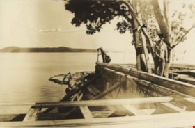
Unidentified persons at a stone wall
https://search.heritageburnaby.ca/link/archivedescription82686
- Repository
- City of Burnaby Archives
- Date
- March 30, 1938
- Collection/Fonds
- Hill family and Vidal family fonds
- Description Level
- Item
- Physical Description
- 1 photograph : sepia ; 4 x 6 cm
- Scope and Content
- Photograph shows two unidentified persons on a stone wall near a body of water. Possibly visible in the photograph is the building site of Yellow Point Lodge.
- Repository
- City of Burnaby Archives
- Date
- March 30, 1938
- Collection/Fonds
- Hill family and Vidal family fonds
- Physical Description
- 1 photograph : sepia ; 4 x 6 cm
- Description Level
- Item
- Record No.
- 550-239
- Access Restriction
- No restrictions
- Reproduction Restriction
- No known restrictions
- Accession Number
- 2013-03
- Scope and Content
- Photograph shows two unidentified persons on a stone wall near a body of water. Possibly visible in the photograph is the building site of Yellow Point Lodge.
- Subjects
- Construction
- Media Type
- Photograph
- Notes
- Title based on contents of photograph
- Note in pencil on album page reads: "March 30, 1938"
- Note in pencil on verso reads: "March 30 - 1938"
Images
