Narrow Results By
Decade
- 2020s 1
- 2010s 6
- 2000s 3
- 1990s 1
- 1980s 2
- 1970s 1
- 1960s 1
- 1950s 2
- 1940s 3
- 1930s 3
- 1920s 3
- 1910s
- 1900s 16
- 1890s 6
- 1880s 3
- 1870s 3
- 1860s 3
- 1850s 1
- 1840s 1
- 1830s 1
- 1820s 1
- 1810s 1
- 1800s 1
- 1790s 1
- 1780s 1
- 1770s 1
- 1760s 1
- 1750s 1
- 1740s 1
- 1730s 1
- 1720s 1
- 1710s 1
- 1700s 1
- 1690s 1
- 1680s 1
- 1670s 1
- 1660s 1
- 1650s 1
- 1640s 1
- 1630s 1
- 1620s 1
- 1610s 1
- 1600s 1
Subject
- Buildings - Commercial - Grocery Stores 1
- Buildings - Industrial - Factories 1
- Buildings - Industrial - Saw Mills 1
- Documentary Artifacts - Architectural Drawings 1
- Education 1
- Employment 1
- First Nations reserves - British Columbia 2
- Indigenous peoples - Indian Territory 2
- Industries - Logging/lumber 1
- Migration 1
- Occupations - Engineers 2
- Occupations - Millworkers 1
Person / Organization
- Canadian Society of Civil Engineers 1
- Hill, Louis Claude "Claude" 1
- Kapoor Sawmills Limited 1
- Manhas, Budhan Kaur 1
- Manhas, Ghania Singh 1
- Manhas, Kashmir Singh 1
- Manhas, Lashman Singh 1
- Manhas, Sher Singh 1
- ʷməθkʷəy̓əm (Musqueam) 2
- Parmar, Kalwant Singh "Nadeem" 1
- Parmar, Surjeet Kaur 1
- Siddoo, Kapoor Singh 1

Geoffrey & Kathleen Burnett Residence
https://search.heritageburnaby.ca/link/landmark582
- Repository
- Burnaby Heritage Planning
- Description
- Residential building.
- Associated Dates
- 1914
- Formal Recognition
- Heritage Designation, Community Heritage Register
- Street View URL
- Google Maps Street View
- Repository
- Burnaby Heritage Planning
- Geographic Access
- Canada Way
- Associated Dates
- 1914
- Formal Recognition
- Heritage Designation, Community Heritage Register
- Enactment Type
- Bylaw No. 13841
- Enactment Date
- 28/05/2018
- Description
- Residential building.
- Heritage Value
- With its long, narrow plan and hipped, cross-gabled roof, this impressive residence was designed for local surveyor and civil engineer Geoffrey Kirby Burnett, who married Kathleen Wallen (1888-1978) in 1916. It was designed by New Westminster architects R.W. Coventry Dick & Son. Beautifully conceived in the British Arts and Crafts style, it features a steeply-gabled roof over the side entry porch, with square timber columns. Other decorative details include half timbering in the gables, first storey casement windows with leaded transom lights and decorative window hoods on the side elevation.
- Locality
- Edmonds
- Historic Neighbourhood
- Edmonds (Historic Neighbourhood)
- Planning Study Area
- Richmond Park Area
- Architect
- R.W. Coventry Dick & Son
- Area
- 903.70
- Contributing Resource
- Building
- Ownership
- Private
- Street Address
- 7037 Canada Way
- Street View URL
- Google Maps Street View
Images

![Survey and Subdivision plans in New Westminster District Group 1 – Burnaby
, [1861]-[1910] thumbnail](/media/hpo/_Data/_BVM_Cartographic_Material/1977/1977_0093_0019a_001.jpg?width=280)
Survey and Subdivision plans in New Westminster District Group 1 – Burnaby
https://search.heritageburnaby.ca/link/museumdescription6988
- Repository
- Burnaby Village Museum
- Date
- [1861]-[1910]
- Collection/Fonds
- Burnaby Village Museum Map collection
- Description Level
- File
- Physical Description
- 14 plans : 3 plans : black ink on paper hand col. + 7 plans : black ink on paper + 4 plans : graphite on paper mounted on 2 sides of cardboard 76 x 102 cm
- Scope and Content
- Item consists of a large board of four New Westminster District Gp 1 - subdivision plans mounted on one side and ten New Westminster District Gp 1 - subdivision plans mounted on the other side. Side A: 1. "Plan /of / Lots 166A, 166 and 167 /, Gr.1, N.W.D. / Showing Misconstructed Roads in Gree…
- Repository
- Burnaby Village Museum
- Collection/Fonds
- Burnaby Village Museum Map collection
- Description Level
- File
- Physical Description
- 14 plans : 3 plans : black ink on paper hand col. + 7 plans : black ink on paper + 4 plans : graphite on paper mounted on 2 sides of cardboard 76 x 102 cm
- Material Details
- Scales [between 1:2376 and 1:7920]
- Index number on edge of board reads: "19"
- Scope and Content
- Item consists of a large board of four New Westminster District Gp 1 - subdivision plans mounted on one side and ten New Westminster District Gp 1 - subdivision plans mounted on the other side. Side A: 1. "Plan /of / Lots 166A, 166 and 167 /, Gr.1, N.W.D. / Showing Misconstructed Roads in Green / 5 chs = 1 in.". (plan is drawn in black ink and hand coloured in red, green and orange ink). A section in the centre of the plan is coloured in red ink and identified as "C.S. Richmond" running from the North Arm of Fraser River to Wiggins Road and divided by "New Wiggins Rd. (as gazetted)" (coloured in orange ink) and two"Constructed Road(s)" (coloured in green ink). Plan is initialed by: "RB" [sic] (in blue pencil crayon) 2. Plan of / Subdivision of / Lot 166 / Group One / New Westminster District / Scale 4 chs = 1 in. / Map No 524". Plan is drawn in graphite and signed by "Surrig [sic] Welhams [sic] / P.L.S." Plan is initialed by: "RB" [sic] (in blue pencil crayon) 3. Plan of "Survey / of Highway / For / Burnaby Council / in / Lots 13 _14 / Group One / Scale 4 chs = 1 in." Signed by "Albert J. Hill, P.L.S." Caribou Street and Caribou Road run through the centre of the plan. Plan is stamped: "Albert J. Hill, Civil Engineer / and / Provincial Land Surveyor, / New Westminster, / B.C.". Plan is initialed by: "RB" [sic] (in blue pencil crayon) 4. A Plan of Lots 166A, 166 and 167, Group One, New Westminster District (drawn in graphite). A section in the centre of the plan is identified as "C.S. Richmond" running from the North Arm of Fraser River and divided by "New Wiggins Rd. (as gazetted)" and two "Constructed Road(s)". Plan is initialed by: "RB" [sic] (in blue pencil crayon) Side B: 1. Small plan drawn in black ink (no title) identifying lots north of the "North Arm" of the Fraser River. Lots identified include: Lot 99, Lot 98, Lot 157, Lot 158, Lot 163, Lot 162, Lot 159, Lot 163, Lot 162, Lot 165, Lot 166A, Lot 155B, Lot 155A and Lot 159. "Scale 40 chains to one inch" . Plan is initialed by: "RB" [sic] (in blue pencil crayon) (Geographic location: Burnaby) 2. Small plan drawn in black ink (no title) identifying lots north of the North Arm of the Fraser River as "Lots 155, 155A, 155B, 155C, 162, 163, 164, 165, 166A and 167". Plan is initialed by: "RB" [sic] (in blue pencil crayon) (Geographic location: Burnaby) 3. Small plan drawn in black ink (no title) which identifies "Lot 151 / Reserve/ for / Race Course"; "Reserve / 64 A / L. 152 G.1"; and other Lots: 32, 33, 34, 35, 36, 38, 39. The plan is signed "Surveyor G.Turn [sic] July / 61 / from Vol 40 R.L. notes [sic]" Plan is stamped: "Albert J. Hill, Civil Engineer / and / Provincial Land Surveyor, / New Westminster, / B.C." Plan is initialed by: "RB" [sic] (in blue pencil crayon) (Geographic location: Burnaby) 4. Small plan drawn in black in with faded red colouring on centre lot identified as "Lot 34" running north from "Vancouver Road" . Plan is stamped: "Albert J. Hill, Civil Engineer / and / Provincial Land Surveyor, / New Westminster, / B.C." Plan is initialed by: "RB" [sic] (in blue pencil crayon) (Geographic location: Burnaby) 5. Plan drawn in graphite and identified as "Lot 98, Gr.1," along with the intials "RB" [sic] (both are handwritten in blue crayon pencil on top of plan) The B.C.E.Railway is identified running through the plan along with Jubilee Road and Royal Oak Road. The plan is signed with the name "Wm. Murray" and the Plan is stamped: "Albert J. Hill, Civil Engineer / and / Provincial Land Surveyor, / New Westminster, / B.C.". (Geographic location: Burnaby) 6. Plan drawn in graphite identified as "Port Lot 13, Gr.1" along with the intials "RB" [sic] (both are handwritten in blue crayon pencil on top of plan) Plan is stamped: "Albert J. Hill, Civil Engineer / and / Provincial Land Surveyor, / New Westminster, / B.C.". (Geographic location: Burnaby) 7.Plan drawn in black ink and identified as "Lot 98 G.1" along with the intials "RB" [sic] (both are handwritten in blue crayon pencil on top of plan). A "Road Reservation" is identified running north between "Electric Tramway" and connecting with "Royal Oak Road". Plan is stamped: "Albert J. Hill, Civil Engineer / and / Provincial Land Surveyor, / New Westminster, / B.C." (Geographic location: Burnaby) 8. Plan drawn in black ink and divided into two sections, the upper plan is identified as "Portion / Lots 100 / area / 101, Gr.1" and the lower plan is identified as "Portion L. 3 G. 1" along with the intials "RB" [sic] (these identifiers are handwritten in blue crayon pencil on top of the plan). Portions of Lot 100 and Lot 101 are each divided into 6 sections and the Portion of Lot 3 plan is divided into 24 sections. The plan includes a note in black ink that reads: " Received from Wm Fromme [sic] / from Wm. Trapp / Nov. 28, 1895 / A. J. T...[sic]". (Geographic location: Burnaby) 9. Plan drawn in black ink (no title) identifying soil, buildings and geographic features in southern Burnaby. The plan is bordered by "New Westminster City" (Tenth Avenue and DL 172) to the south east and DL 173 to the south, DL 158 to the west and the B.C.E. Tramway to the north. Plan includes District Lots: 155A, 158, 159, 171, 160, 53 and 95 and identifies soil, marshland and ravines throughout. Plan identifies the following features: a "Team Road" running through Lots 158 and 159 along with "Fair Orchard Soil / Even Surface Throughout / No Ravines", "Gravel and Shingle" (bottom of Lot 158), "North Arm Road" crossing "Byrne Road" and connecting with "Power House Road" which runs north to connect with "Highland Park Station" and the B.C.E. Tramway, "Power Ho" in the northeast corner of DL 160, a "Brook" connected with a "Deep Ravine" running between DL 53, DL 95 and DL 160 along with "Good Soil" and "Fair Orchard Soil" identified nearby in DL 95. Scale is identified as "10 chs = 1 in." Plan is stamped: "Albert J. Hill, Civil Engineer / and / Provincial Land Surveyor, / New Westminster, / B.C." Plan is initialed by: "RB" [sic] (in blue pencil crayon) (Geographic location: Burnaby) 10. Plan drawn in black ink (no title) with Burnaby Lake and Deer Lake at the centre. The plan is bordered by the following District Lots identified as: 117, 118 and 68 to the west, Lots 80, 79 and 85 to the southwest, Lots 11, 13, and 1 (City of New Westminster) to the south east, the North Road boundary to the east and Lots 8, 56, 57, 59, and 136 to the North. The lower right hand corner of the plan has a small inset which reads: "Burnaby Lake" and "Page 19 R.B. Notes". Plan is initialed by: "RB" [sic] (in blue pencil crayon) (Geographic location: Burnaby)
- Creator
- Hill, Albert James
- Accession Code
- HV977.93.19
- Access Restriction
- No restrictions
- Reproduction Restriction
- No known restrictions
- Date
- [1861]-[1910]
- Media Type
- Cartographic Material
- Scan Resolution
- 300
- Scale
- 72
- Notes
- Title based on contents of file
- Scale is measured in chains. (One chain equals 792 inches)
- The term "Lot" can also refer to a "District Lot”
- Some plans are stamped: "Albert J. Hill, Civil Engineer / and / Provincial Land Surveyor, / New Westminster, / B.C." and intialed: "RB" [sic]
Images
![Survey and Subdivision plans in New Westminster District Group 1 – Burnaby
, [1861]-[1910] thumbnail](/media/hpo/_Data/_BVM_Cartographic_Material/1977/1977_0093_0019a_001.jpg)

![Survey and Subdivision plans in New Westminster District Group 1 – Burnaby, [1905-1917] thumbnail](/media/hpo/_Data/_BVM_Cartographic_Material/1977/1977_0093_0022a_001.jpg?width=280)
Survey and Subdivision plans in New Westminster District Group 1 – Burnaby
https://search.heritageburnaby.ca/link/museumdescription6991
- Repository
- Burnaby Village Museum
- Date
- [1905-1917]
- Collection/Fonds
- Burnaby Village Museum Map collection
- Description Level
- File
- Physical Description
- 12 plans : 6 black ink on paper + 2 black & col. ink on paper + 4 graphite on paper
- Scope and Content
- Item consists of a large board of six New Westminster District subdivision plans mounted on one side and six New Westminster District subdivision plans mounted on the other side. Side A: 1. Plan drawn in graphite with markings in black ink "Surveyed for Mr. W. Wilson / Paterson Stat. B.C.E.R." . …
- Repository
- Burnaby Village Museum
- Collection/Fonds
- Burnaby Village Museum Map collection
- Description Level
- File
- Physical Description
- 12 plans : 6 black ink on paper + 2 black & col. ink on paper + 4 graphite on paper
- Material Details
- Scales [between 1:360 and 1:3168]
- Index number on edge of board reads: "22"
- Scope and Content
- Item consists of a large board of six New Westminster District subdivision plans mounted on one side and six New Westminster District subdivision plans mounted on the other side. Side A: 1. Plan drawn in graphite with markings in black ink "Surveyed for Mr. W. Wilson / Paterson Stat. B.C.E.R." . Plan includes subdivision of lots situated between B.C.E. Railway and Vancouver Road (Kingsway). (Geographic location: Burnaby) 2. Subdivision plan (no title) drawn in black ink with annotations in graphite. Plan covers District Lots 2, 4 and 6, west of North Road. Plan is stamped: "Albert J. Hill, Civil Engineer / and / Provincial Land Surveyor, / New Westminster, / B.C. (Geographic location: Burnaby) 3. Plan of "Portion of Municipality" with intials "RB" [sic] (handwritten in blue crayon). Plan covers the area north east of the City of New Westminster including District Lots 11, 13, 14, 12, 1 and 2. Plan is stamped: "Albert J. Hill, Civil Engineer / and / Provincial Land Surveyor, / New Westminster, / B.C. (Geographic location: Burnaby) 4."Plan / of Subdivision of / N.W.1/4 Lot 175 / Group 1 New West. Dist. / B.C. / Scale 4 chs = 1 in. " Plan is stamped: "Albert J. Hill, Civil Engineer / and / Provincial Land Surveyor, / New Westminster, / B.C. and initialed : "RB" [sic] (in blue pencil crayon) (Geographic location: Burnaby) 5. "Subdivision / of a Portion of / Lot 15 Group 1 / New Westminster Dist. / Scale 4 chs = 1 in". Plan provides numbered sudivisions - Lots 1 to 15 of District Lot 15 in red ink. (Geographic location: Burnaby) 6. Plan of "Central Park & / Vicinity" Plan includes subdivisions of District Lot 153 east of Central Park District Lot 151 and subdivision of District Lot 36 and 49 west of Boundary Road (Vancouver). Plan is stamped: "Albert J. Hill, Civil Engineer / and / Provincial Land Surveyor, / New Westminster, / B.C. and initialed : "RB" [sic] (in blue pencil crayon). (Geographic location: Burnaby) Side B: 1. Subdivision plan (no title) drawn in black ink. Plan identifies lots between Vancouver Road (Yale Road is crossed out and replaced with Vancouver Road) and B.C.E. Railway. "Scale 2 chs = 1 in" (Geographic location: Burnaby) 2. Plan of "Subdivision Lot 1 / Lot 69 Gr. 1 / Scale 30' = 1 " " Plan identifies Boundary Road, Still Creek and a Road Allowance between District Lot 118 and District Lot 69. Plan was "Surveyed for Burnaby Mun. Council / March 11th 1908 / G.K.B." (Geographic location: Burnaby) 3. Plan drawn in black ink (no title) showing a subdivision in Lot 25 with names "Newcomb", "Debeck" and "Armstrong" along with roads identified as Third Street, Cumberland Street, Armstrong Street and Cariboo [sic] Street and including Lots 27, 11 and 13.Plan is stamped: "Albert J. Hill, Civil Engineer / and / Provincial Land Surveyor, / New Westminster, / B.C. and initialed : "RB" [sic] (in blue pencil crayon). (Geographic location: Burnaby) 4. Handrawn subdivision plan in graphite titled: "Lot 13, Gr.1" with intials "RB" [sic] (handwritten in blue crayon). Plan is bordered by Armstrong Street (Lot 11, G.1), Cumberland St. (Lot 25, G.1) and Tenth Avenue (City Boundary). The plan is singed by "Albert J. Hill / P.L.S." and one of the subdivided lots is identified with the name: "W. Karrymann". (Geographic location: Burnaby) 5. Handrawn sketch in graphite titled: "Lot 88, Gr.1" with intials "RB" [sic] (handwritten in blue crayon). Plan appears to be a draft of a subdivision plan of a portion of District Lot 88 along Cumberland Road. The plan is signed: "16/7/17 _W.F. Draper [sic] / B.C.L.S." (Geographic location: Burnaby) 6. "Plan / of Subdivision / of Blocks 61, 62 and 2 / Lot 30 / Group 1 / N.W. Dist. / Scale 1ch = 1 in". Plan is intialed by: "PB" with a note: "Also see board 2 / for duplicate" (handwritten in blue crayon). (Geographic location: Burnaby)
- Creator
- Hill, Albert James
- Geographic Access
- Boundary Road
- Kingsway
- Cumberland Street
- Accession Code
- HV977.93.22
- Access Restriction
- No restrictions
- Reproduction Restriction
- No known restrictions
- Date
- [1905-1917]
- Media Type
- Cartographic Material
- Historic Neighbourhood
- Central Park (Historic Neighbourhood)
- Scan Resolution
- 300
- Scale
- 100
- Notes
- Title based on contents of file
- Scale is measured in chains and feet. (One chain equals 792 inches)
- The term "Lot" can also refer to a "District Lot”
- Some plans are stamped: "Albert J. Hill, Civil Engineer / and / Provincial Land Surveyor, / New Westminster, / B.C." and intialed: "RB" [sic]
Images
![Survey and Subdivision plans in New Westminster District Group 1 – Burnaby, [1905-1917] thumbnail](/media/hpo/_Data/_BVM_Cartographic_Material/1977/1977_0093_0022a_001.jpg)

![Survey and Subdivision plans in New Westminster District Group 1 – Burnaby
, [1900-1910] thumbnail](/media/hpo/_Data/_BVM_Cartographic_Material/1977/1977_0093_0018a_001.jpg?width=280)
Survey and Subdivision plans in New Westminster District Group 1 – Burnaby
https://search.heritageburnaby.ca/link/museumdescription6987
- Repository
- Burnaby Village Museum
- Date
- [1900-1910]
- Collection/Fonds
- Burnaby Village Museum Map collection
- Description Level
- File
- Physical Description
- 9 plans : 1 plan : blueprint ink on paper + 6 plans : black ink on paper + 2 plans : graphite on paper mounted on 2 sides of cardboard 76 x 102 cm
- Scope and Content
- Item consists of a large board of five New Westminster District Gp 1 - subdivision plans mounted on one side and four New Westminster District Gp 1 - subdivision plans mounted on the other side. Side A: 1. "Plan / of Subdivision of / a Portion / of / Lot 13, Gr.1 / New Westminster District / Scal…
- Repository
- Burnaby Village Museum
- Collection/Fonds
- Burnaby Village Museum Map collection
- Description Level
- File
- Physical Description
- 9 plans : 1 plan : blueprint ink on paper + 6 plans : black ink on paper + 2 plans : graphite on paper mounted on 2 sides of cardboard 76 x 102 cm
- Material Details
- Scales [between 1:1200 and 1:7920]
- Index number on edge of board reads: "18"
- Scope and Content
- Item consists of a large board of five New Westminster District Gp 1 - subdivision plans mounted on one side and four New Westminster District Gp 1 - subdivision plans mounted on the other side. Side A: 1. "Plan / of Subdivision of / a Portion / of / Lot 13, Gr.1 / New Westminster District / Scale - 2 chs = 1 in." Plan is bordered by Armstrong Street and Cariboo Street with Lillooet Street running through the centre. (Geographic location: Burnaby) 2. Plan of "Lot 98, Gr.1" (handwritten in blue pencil). Plan identifies lots running south of "Vancouver Road (later became Kingsway in 1912) and Royal Oak Road running north - south. Plan is stamped with: "Albert J. Hill, Civil Engineer". (Geographic location: Burnaby) 3. Plan of "Lot 85, Gr.1" (handwritten in blue pencil). "Scale 10 chs = 1 in. / Albert J. Hill / B.C.L.S." Plan is bordered by Deer Lake and Lot 84, Hastings Road, Haszard Road and idenfities Pole Line Road running through the centre. (Geographic location: Burnaby) 4. "Plan / of / Subdivision Lot 'G' / in the Subdivision of / Lot 96, Gr.1 / New Westminster District / Scale 100 ' = 1 in." The subdivision plan is bordered by False Creek Road and Westminster & Vancouver Tramway. 5. Plan (drawn in pencil) "Mr. Madill, Mar. 29/09" of "Lot 90 , G.1" / "Scale 200 ' = 1 " / Albert J. Hill, B.C.L.S." Plan is bordered by Lot 87 and Lot 91 and Hastings Road. (Geographic location: Burnaby) Side B: 1. Plan of "Extension / of the Gunn Rd. / Through / Lots 40, 42, 43 and 44, / Group One / Scale 300' = 1"" . Plan is stamped with: "Albert J. Hill, Civil Engineer / and / Provincial Land Surveyor, / New Westminster, / B.C." Road is identified running from Bainbridge Road and Vancouver Westminster Railway through Lot 44 to Lot 10. (Geographic location: Burnaby) 2. Blueprint Plan of "Lot 98, G.1" (handwritten in blue pencil) The plan identifies the Westminster & Vancouver Tramway Line, and is bordered by Lot 158 and Lot 99. Plan is stamped with: "Albert J. Hill, Civil Engineer / and / Provincial Land Surveyor, / New Westminster, / B.C." (Geographic location: Burnaby) 3. Plan, graphite on paper titled: "Lot 28, Gr.1," (handwritten in blue pencil) and titled "Cliff's Survey" with "Scale 2 chs = 1 in." Plan is bordered by Tramway, Sixth Street and Fourth Street. "Plan is stamped with: "Albert J. Hill, Civil Engineer / and / Provincial Land Surveyor, / New Westminster, / B.C." (Geographic location: Burnaby) 4. "Plan / of Subdivision / of / Subdivision Block XIII, / Lot 27, / Group One / New Westminster Dist." Scale 2 chs = 1 in. " Plan is bordered by Second Street to the east and Fourth Street to the west. Plan is stamped: "Albert J. Hill, Civil Engineer / and / Provincial Land Surveyor, / New Westminster, / B.C." (Geographic location: Burnaby)
- Creator
- Hill, Albert James
- Accession Code
- HV977.93.18
- Access Restriction
- No restrictions
- Reproduction Restriction
- No known restrictions
- Date
- [1900-1910]
- Media Type
- Cartographic Material
- Scan Resolution
- 300
- Scale
- 72
- Notes
- Title based on contents of file
- Scale is measured in chains and feet. (One chain equals 792 inches)
- The term "Lot" can also refer to a "District Lot”
Images
![Survey and Subdivision plans in New Westminster District Group 1 – Burnaby
, [1900-1910] thumbnail](/media/hpo/_Data/_BVM_Cartographic_Material/1977/1977_0093_0018a_001.jpg)

![Survey and Subdivision plans in New Westminster District Group 1 – Burnaby
, [1905-1912] thumbnail](/media/hpo/_Data/_BVM_Cartographic_Material/1977/1977_0093_0021a_001.jpg?width=280)
Survey and Subdivision plans in New Westminster District Group 1 – Burnaby
https://search.heritageburnaby.ca/link/museumdescription6990
- Repository
- Burnaby Village Museum
- Date
- [1905-1912]
- Collection/Fonds
- Burnaby Village Museum Map collection
- Description Level
- File
- Physical Description
- 10 plans : 2 blueprint on paper + 7 black ink on paper + 1 graphite on paper mounted on cardboard 76 x 102 cm
- Scope and Content
- Item consists of a large board of five New Westminster District subdivision plans mounted on one side and five New Westminster District subdivision plans mounted on the other side. Side A: 1. "Survey / of / a Portion / of / Lot 95 Gr.1 / Scale : 1 ch = 1 in". Plan shows Lot 9, Lot 10 and Lot 11 o…
- Repository
- Burnaby Village Museum
- Collection/Fonds
- Burnaby Village Museum Map collection
- Description Level
- File
- Physical Description
- 10 plans : 2 blueprint on paper + 7 black ink on paper + 1 graphite on paper mounted on cardboard 76 x 102 cm
- Material Details
- Scales [between 1:792 and 1:3960]
- Index number on edge of board reads: "21"
- Scope and Content
- Item consists of a large board of five New Westminster District subdivision plans mounted on one side and five New Westminster District subdivision plans mounted on the other side. Side A: 1. "Survey / of / a Portion / of / Lot 95 Gr.1 / Scale : 1 ch = 1 in". Plan shows Lot 9, Lot 10 and Lot 11 of District Lot 95, northeast of Vancouver Road and B.C.E. Tramway. Plan is initialed by: "RB" [sic] (in blue pencil crayon) (Geographic location: Burnaby) 2. Plan of "Lot 12, 13, 2, Gr.1" (handwritten in blue crayon) with Note: "Figures shown in / Red are from Reg. / Plan No 898" and "Scale 4 chains to 1 inch" (written in graphite). Plan identifies the Brunette River running through Lot 12, Lot 13 and Lot 1 and is bordered by North Road to the east and Cariboo Road to the south west. Plan is initialed by: "RB" [sic] (in blue pencil crayon) and stamped: "Albert J. Hill, Civil Engineer / and / Provincial Land Surveyor, / New Westminster, / B.C." (Geographic location: Burnaby) 3. Subdivision plan of a "Portion / of / Lot 29 Gr.1" The plan shows Lots two through fourteen North of Vancouver Road. Name on plan reads: "Reichenbach" and "Scale 2 chs = 1 in" . Plan is initialed by: "RB" [sic] (in blue pencil crayon) nd stamped: "Albert J. Hill, Civil Engineer / and / Provincial Land Surveyor, / New Westminster, / B.C." (Geographic location: Burnaby) 4. Plan of "SUBDvn 10, L88 / "Sc. 1 ch = 1 in / Albert J. Hill / P.L.S.". Plan shows Lot 88 and Lot 25 running along a ravine and Cumberland Street and identifies the "Jensen" house as well as a "stable" and "barn". Plan is initialed by: "RB" [sic] (in blue pencil crayon) and stamped: "Albert J. Hill, Civil Engineer / and / Provincial Land Surveyor, / New Westminster, / B.C." Note handwritten in pencil reads: "Cancelled / See other Side". See also plan 3B. (Geographic location: Burnaby) 5. "Survey / of / Roberts Road / and / Power House Road / Scale 200' = 1" ". Survey for roads identifies North Arm Road, Byrne Road, Woollard, Lot 155A, Lot 160, Lot 159, Lot 96 and Lot 97. Plan is initialed by: "RB" [sic] (in blue pencil crayon) and stamped: "Albert J. Hill, Civil Engineer / and / Provincial Land Surveyor, / New Westminster, / B.C." (Geographic location: Burnaby) Side B: 1. Plan of "Lot 29, G. 1" "McDonald's Lot / Vancouver Road". Plan shows the subdivision of District Lot 29 with the name "S McDonald" marked on one lot next to another identified as "Carter Smith". Lots within survey plan are all north of Vancouver Road and west of Wise Road. Plan is initialed by: "RB" [sic] (in blue pencil crayon) (Geographic location: Burnaby) 2. Plan of "Location / for Burnaby Council / of / the West Boundary of Lots 161 & 175 / Group One" Plan is initialed by: "RB" [sic] (in blue pencil crayon) and stamped: "Albert J. Hill, Civil Engineer / and / Provincial Land Surveyor, / New Westminster, / B.C." (Geographic location: Burnaby) 3. Blueprint plan of "SUBDvn 10, L88 / "Sc. 1 ch = 1 in / Albert J. Hill / P.L.S.". Subdivision plan shows Lot 88 and Lot 25 running along a ravine and Cumberland Street and identifies the "Jensen" house as well as a "stable" and "barn". Plan is initialed by: "RB" [sic] with note "Previous map on / other side hereof" (in blue pencil crayon). See also plan 4A. (Geographic location: Burnaby) 4. Plan titled: "Western Addition / Plan of Subdivision / of / Lots 159_160 / and Part of / Lot 158 / Group One / New Westminster District / Scale : 5 chs = 1 in / to The City of / New Westminster." Plan is initialed by: "RB" [sic] (in blue pencil crayon) (Geographic location: Burnaby) 5. Plan "of Resubdivision/ of Lot 11 / in the Subdivision / of Lots D, C, & G / Lot 96 / Group One / New Westminster District / Scale 2 ch = 1 in" Plan is initialed by: "RB" [sic] (in blue pencil crayon) (Geographic location: Burnaby)
- Creator
- Hill, Albert James
- Accession Code
- HV977.93.21
- Access Restriction
- No restrictions
- Reproduction Restriction
- No known restrictions
- Date
- [1905-1912]
- Media Type
- Cartographic Material
- Scan Resolution
- 300
- Scale
- 72
- Notes
- Title based on contents of file
- Scale is measured in chains and feet. (One chain equals 792 inches)
- The term "Lot" can also refer to a "District Lot”
Images
![Survey and Subdivision plans in New Westminster District Group 1 – Burnaby
, [1905-1912] thumbnail](/media/hpo/_Data/_BVM_Cartographic_Material/1977/1977_0093_0021a_001.jpg)

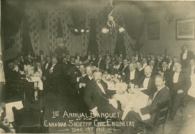
First Annual Banquet of the Canadian Society of Civil Engineers, 1912
https://search.heritageburnaby.ca/link/museumdescription916
- Repository
- Burnaby Village Museum
- Date
- December 14, 1912
- Collection/Fonds
- Burnaby Village Museum Photograph collection
- Description Level
- Item
- Physical Description
- 1 photograph : b&w ; 12.6 x 18.1 cm mounted on cardboard 18.5 x 23.7 cm
- Scope and Content
- Photograph of a large group of men seated at their tables in a banquet hall for the first annual banquet of the Canadian Society of Civil Engineers. At the table to the right side of the photograph, the row of gentlemen on the left side of the long table are seated with their chairs turned away fr…
- Repository
- Burnaby Village Museum
- Collection/Fonds
- Burnaby Village Museum Photograph collection
- Description Level
- Item
- Physical Description
- 1 photograph : b&w ; 12.6 x 18.1 cm mounted on cardboard 18.5 x 23.7 cm
- Scope and Content
- Photograph of a large group of men seated at their tables in a banquet hall for the first annual banquet of the Canadian Society of Civil Engineers. At the table to the right side of the photograph, the row of gentlemen on the left side of the long table are seated with their chairs turned away from the table for the photograph. An arrow drawn in pencil on the right side of the photograph is pointing to a man identified as James Douglas Smith (seated second from the front end of the table, on the side of the table nearer the photographer).
- Accession Code
- HV974.23.8
- Access Restriction
- No restrictions
- Reproduction Restriction
- No known restrictions
- Date
- December 14, 1912
- Media Type
- Photograph
- Scan Resolution
- 600
- Scan Date
- 2023-04-25
- Notes
- Title based on contents of photograph
- An annotation on the back of the photo reading "J. D. Smith" may be referring to this man. Inscribed on the negative and printed on the bottom front of the photograph: "1st Annual Banquet / of the / Canadian Society of Civil Engineers / Dec 14th 1912."
Images
![Survey and Subdivision plans in New Westminster District Group 1 and Group 2 – Vancouver, ʷməθkʷəy̓əm (Musqueam) Indian Reserve, Burnaby, Surrey
, [1910-1911] thumbnail](/media/hpo/_Data/_BVM_Cartographic_Material/1977/1977_0093_0017_001.jpg?width=280)
Survey and Subdivision plans in New Westminster District Group 1 and Group 2 – Vancouver, ʷməθkʷəy̓əm (Musqueam) Indian Reserve, Burnaby, Surrey
https://search.heritageburnaby.ca/link/museumdescription6986
- Repository
- Burnaby Village Museum
- Date
- [1910-1911]
- Collection/Fonds
- Burnaby Village Museum Map collection
- Description Level
- File
- Physical Description
- 9 plans : 4 plans : blueprint ink on paper + 4 plans : black ink on paper + 1 plan : graphite on paper mounted on 2 sides of cardboard 76 x 102 cm
- Scope and Content
- File consists of a large board of three survey plans in New Westminster District Group 1 mounted on one side and six survey and subdivision plans of District Lot 85, New Westminster District Group 1 mounted on the other side. Side A: 1. Plan : blueprint on paper ; 30.5 x 80 cm. Title reads: "Fras…
- Repository
- Burnaby Village Museum
- Collection/Fonds
- Burnaby Village Museum Map collection
- Description Level
- File
- Physical Description
- 9 plans : 4 plans : blueprint ink on paper + 4 plans : black ink on paper + 1 plan : graphite on paper mounted on 2 sides of cardboard 76 x 102 cm
- Material Details
- Scales vary (One chain equals 792 inches)
- Indexed number on tape on edge of board reads "17"
- Scope and Content
- File consists of a large board of three survey plans in New Westminster District Group 1 mounted on one side and six survey and subdivision plans of District Lot 85, New Westminster District Group 1 mounted on the other side. Side A: 1. Plan : blueprint on paper ; 30.5 x 80 cm. Title reads: "Fraser River Bridge / Plan of South Approach". Plan covers area of land north of the Fraser River and Great Northern Railway with approach for a bridge running through the "ʷməθkʷəy̓əm (Musqueam) Indian Reserve" (ʷməθkʷəy̓əm (Musqueam) First Nation) and lots marked as Dominion Government and the east half of Lot 2 identified as "C. F. Brown" "Plan 851". Plan is identified as "Plan 851 / traced / Mar. 17, 1911". (Geographic location in Vancouver) Scale: 100 feet = 1 inch, Signed by Albert J. Hill / P.L.S." 2. Plan : blueprint on paper ; 36.5 x 35 cm (no title). Includes three plans of lots on the east and west sides of North Road. Note on bottom of blueprint reads: "I.E.B. McKay Surveyor General - hereby certify / that this is a correct tracing from the field / notes of the Royal Engineers on file in the / Lands Department / E.B. McKay (signature) / Surveyor General / Victoria B.C. April 11th 1911" . Plan in top left titled "Page 11 / Vol. 1. / R.E. Notes" covers District Lots east of North Road including Lot 5, Lot 7, Lot 41, Lot 9 and Lot 107 in Coquitlam. Plan in top right corner titled "Page 17 / Vol. 1. / R.E. Notes" covers District Lots east of North Road including Lot 104, Lot 54, Lot 105, Lot 55, Lot 106, Lot 9 and Lot 107 in Coquitlam and Port Moody. Plan in lower left corner titled "Page 15 / Vol. 1 / R.E. Notes" covers District Lots west of North Road including Lot 147, Lot 148, Lot 100, Lot 15 in Burnaby. 3. Plan : blue print on paper ; 29.5 x 41.5 cm. (no formal title). Plan of the North 1/2 of Section 18. Plan covers area in the "North 1/2 of Sec.18 B.5 N RGE 1 W" and "Sec. 18 B.5 N. RGE 1 W" bordered by Section 7, Section 13, Section 17 and Section 19. Bon Accord Road runs through Sec. 18. The plan is signed by surveryor "I.H. Neville Smith... C.E.B.C.L.S. / Mar. 26th 1910" and signed by "Ludwig Pillath". (Geographic location: Surrey) Side B: 1. Plan : blueprint on paper ; 43.5 x 49.5 cm. Title reads: "Plan / of Subdivision / of a Portion / of / Lot 85 / Group One / New Westminster District. Plan covers portion of land east of Deer Lake and Pole Line Road (Sperling Avenue) and south of Hastings Road in District Lot 85 in Burnaby with section 4 and a portion of section 2 coloured in red. Plan is signed by "Albert J. Hill, B.C.L.S." Plan is initialed by: "RB" [sic] (in blue pencil crayon) Scale: 4 chains = 1 inch 2. Plaln : black black ink on linen ; 39 x 37 cm. Title reads: "L.C. Hill's Property, / Burnaby". Plan covers a triangular portion of land east of Pole Line Road (Sperling Avenue) and south of Hastings Road in District Lot 85 in Burnaby. Plan is intitaled by "RB" [sic] (in blue pencil crayon). Scale: 3 chains = 1 mile 3. Plan : graphite on paper ; 23 x 17 cm. Title reads: "Portion of Lot 85 / Gr.1". Plan covers portion of land north east of Deer Lake and west of Pole Line Road (now Sperling Avenue) in District Lot 85 in Burnaby. Plan is stamped in red ink: "Albert J. Hill, Civil Engineer". Plan is initialed by: "RB" [sic] (in blue pencil crayon). Scale: 1 chain = 1 inch 4. Plan : black ink on linen ; 16 x 19 cm. Title reads: "Lot 85". Plan covers the intersection of Pole Line Road (Sperling Avenue) and Hastings Road at the north west section of District Lot 79 and District Lot 85 in Burnaby. Plan is stamped: "A.J. Hill, Civil Engineer" with identitifed in blue pencil crayon. 5. Plan : black ink on paper ; 28.5 x 37 cm. (no formal title) Plan covers an area of land, west of Pole Line Road (Sperling Avenue) and south of Deer Lake in District Lot 85 in Burnaby. Plan is initialed by: "RB" [sic] (in blue pencil crayon) 6. Plan : black ink on paper ; 21 x 34 cm (no formal title). Plan covers an area of land, west of Pole Line Road (Sperling Avenue) and south of Deer Lake in District Lot 85 in Burnaby. Plan is initialed by: "RB" [sic] (in blue pencil crayon)
- Accession Code
- HV977.93.17
- Access Restriction
- No restrictions
- Reproduction Restriction
- No known restrictions
- Date
- [1910-1911]
- Media Type
- Cartographic Material
- Historic Neighbourhood
- Burnaby Lake (Historic Neighbourhood)
- Burquitlam (Historic Neighbourhood)
- Planning Study Area
- Morley-Buckingham Area
- Douglas-Gilpin Area
- Scan Resolution
- 600
- Scan Date
- 2023-06-26
- Notes
- Title based on contents of file
- Scale is measured in chains and feet. (One chain equals 792 inches).
- The term "Lot" also refers to a "District Lot”
- Some plans are stamped: "Albert J. Hill, Civil Engineer / and / Provincial Land Surveyor, / New Westminster, / B.C." and intialed: "RB" [sic]
Zoomable Images
![Survey and Subdivision plans in New Westminster District Group 1 and Group 2 – Vancouver, ʷməθkʷəy̓əm (Musqueam) Indian Reserve, Burnaby, Surrey
, [1910-1911] thumbnail](/media/hpo/_Data/_BVM_Cartographic_Material/1977/1977_0093_0017_003_seadragon/1977_0093_0017_003.jpg?w=280)
Survey and Subdivision plans in New Westminster District Group 1 and Group 2 – Vancouver, ʷməθkʷəy̓əm (Musqueam) Indian Reserve, Burnaby, Surrey , [1910-1911]
Zoom into Image
Interview with Kalwant Singh "Nadeem" Parmar
https://search.heritageburnaby.ca/link/museumdescription19346
- Repository
- Burnaby Village Museum
- Date
- [1600-2022] (interview content), interviewed 7 Oct. 2022
- Collection/Fonds
- Burnaby Village Museum fonds
- Description Level
- Item
- Physical Description
- 2 sound recordings (wav) (111 min., 51 sec.) + 1 sound recording (mp3) (111 min., 51 sec.)
- Scope and Content
- Item consists of a recording of an oral history interview with Kalwant Singh "Nadeem" Parmar conducted by interviewers, Anushay Malik and Rajdeep with assistance from Burnaby Village Museum Assistant Curator, Kate Petrusa. During the interview Kalwant Singh "Nadeem" Parmar discusses and provides in…
- Repository
- Burnaby Village Museum
- Collection/Fonds
- Burnaby Village Museum fonds
- Series
- Museum Oral Histories series
- Description Level
- Item
- Physical Description
- 2 sound recordings (wav) (111 min., 51 sec.) + 1 sound recording (mp3) (111 min., 51 sec.)
- Material Details
- Interviewers: Anushay Malik, Rajdeep Co Interviewer and technical support: Kate Petrusa Interviewee: Nadeem Parmar Location of Interview: Residence of Nadeem Parmar in Burnaby Interview Date: October 7, 2022 Total Number of tracks: 2 Total Length of all Tracks: 01:51:51 min Digital master recordings (wav) were recorded onto two separate audio tracks, edited and merged together and converted to mp3 for access on Heritage Burnaby
- Scope and Content
- Item consists of a recording of an oral history interview with Kalwant Singh "Nadeem" Parmar conducted by interviewers, Anushay Malik and Rajdeep with assistance from Burnaby Village Museum Assistant Curator, Kate Petrusa. During the interview Kalwant Singh "Nadeem" Parmar discusses and provides information on; his ancestral background, his education, his employment background, his experiences of racial discrimmination as a South Asian immigrant, saw mills established by South Asian relations in Paldi (Vancouver Island), in North Vancouver and Burnaby, family relations in the South Asian Canadian community and in regions in Punjab, the caste system, his literary works, locations of family homes in Burnaby, the architectural design of his house, personal stories and anecdotal information as a South Asian Canadian living and working in Canada. 00:00 – 01:45 The framework and purpose of the interview is explained to interviewee Nadeem Parmar by interviewers Rajdeep and Anushay Malik. The interviewers explain how the information from this interview can be drawn on for Burnaby Village Museum’s future exhibits and also how researchers will learn more about the history of the South Asian community in Burnaby through residents’ stories. Interview begins with Nadeem providing his full name "Kulwant Singh Parmar". He clarifies that his name was given to him by his grandfather who was a civil engineer and that his father also worked as a civil engineer. Nadeem expresses that he was born with a “silver spoon in his mouth” as a descendent of his maternal grandfather who was a successful landlord. Nadeem explains that when the Partition of India came into effect, (1947) he was 11 years old. He and his family left the partitioned side, his native village was located in Punjab and his forefathers were located in Rajasthan. 3:20 – 4:57 Nadeem explains further about his forefathers who came from Rajasthan. He shares information about his ancestor on his father’s side, named Vijay Singh who was friends with Emperor Jahangir. When fighting began against Jahangir he left the area to head to the middle of central India, then to the Punjab area with small states. As a clan, as a Parmar, he conveys there were about eleven or twelve villages with the same name. Interviewer, Anushay helps Nadeem to clarify the time period of this information. Nadeem refers to the time period being similar to the epic historical film “Moghal-e-Azam” and Anushay confirms the time period being the 1600s when they left Rajasthan. 4:58 – 10:59 Interviewer Anushay asks Nadeem to about his migration to Canada. Nadeem conveys that his first ancestor on his in-laws side of the family migrated around 1889. Further discussion ensues about reading Punjabi and how interviewer Rajdeep can read Punjabi and that she comes from the village of "Lakhpur" in Punjab. Rajdeep notes that “Lakhpur” is near "Phagwara". Nadeem clarifies that his village is "Panchat" and this family used to live in "Phagwara". and Nadeem and Rajdeep compare their familiarity and memories of the area. Nadeem conveys some of his comments in Punjabi and then changes to English. Nadeem recollects when the Japanese bombarded Shillong, he was around seven years old and attended missionary school. The only languages that were taught were English and Persian. Nadeem conveys that his mother had hopes of Nadeem becoming an army officer and moving up the ranks but Nadeem wasn’t interested. Nadeem attended college, graduated with a Bachelor of Science, BSC with Physics and Chemistry, followed by another Bachelor’s Degree in Political Science and finally a degree in his favourite subject in the language of Urdu. He completed these degrees in Punjab in Doaba College, Jalandher. Nadeem recollects how he started teaching but wasn’t getting paid very well. When he was at college, with encouragement from his professor, Veer Pankalia [sic] he began writing poetry and short plays. His professor also introduced him to a famous poet of Punjab, Mila Ram Offa [sic] and he gave him the name of Nadeem. Nadeem explains the meaning of the name “Nadeem” “…the one who know about it, inside out…” even though we generally think of the meaning being “friend” it’s not just about friend. 11:00 -24:48 Nadeem provides background information on how he ended up marrying his future wife who was born in India and immigrated to Canada with her family. Nadeem explains how the marriage was arranged through family relations that were already established in Punjab over a century ago. One of his wife’s ancestors, head of the family called “baniye” (traders) immigrated to Canada in [1899]. This relation returned to Punjab where he had nephews, the youngest of the nephews was Nadeem’s father (Lashman Singh Manhas) in law’s father (Sher Singh Manhas). He expresses that his wife’s ancestor couldn’t bring Nadeem’s father in law’s father since he was only 12 or 13 years old but he brought three of the nephews back to Canada with him. The nephews were named, Pola Singh, Ginaya Singh and Doman Singh (also named Dolmans). He describes how the group left India but it took them two to three years before they arrived in Canada. The group travelled to Burma, Indonesia and Hong Kong before landing in San Francisco. From San Francisco they walked and worked on the rail line before entering Canada and arriving in Grand Forks. The men got work on the construction of the Canadian Pacific Railway (CPR) and eventually made their way to the lower mainland. Nadeem conveys that the younger brother of Ginaya Singh, Maya Singh joined the others in Canada taking the same route, arriving in Bridal Falls where they were working at a saw mill and in CP rail construction. He describes Maya Singh as business minded and since he was too young to work in the mill, he began working as a cook and then began growing potatoes on land that he leased from a Dutch land owner. The local mill at Bridal Falls was facing bankruptcy and Maya Singh arranged to lease the mill, eventually buying it. From there the group moved their business to Strawberry Hill in Surrey and when the sale of logs declined, they moved over to Vancouver Island and established a sawmill with Doman Singh in the community of Paldi (originally known as Mayo Lumber) near Duncan. He explains further how the South Asian community helped each other like they did back home. He clarifies that his father in law’s father is the youngest cousin of Ginaya and Doman Singh and when he died, his father in law’s younger brother started Kashmir Lumber. Eventually his father in law (Lashman Singh Manhas) and the rest of the whole family including cousins and nephews were sponsored by their relations and immigrated to Canada. Nadeem explains how in 1959, his brother in law returned home to Punjab to get married, bringing his family with him. He tells of how during this time period, a marriage was arranged by his parents for him to marry his future wife. Nadeem recollects how this came to be. Nadeem and his wife Surjeet married in Punjab in December 1960, Nadeem was 24 years old and his wife was 18 years old. 24:49 – 39:42 Nadeem describes how he obtained his teaching degree from Ramgarhia College in Phagwara (located in the Kapurhtala district of Punjab) and after a disagreement with a teacher at home, he decided to go to England. He explains how he joined his brother who had moved to England and was working as a labourer. Nadeem tells of the difficulties he faced applying for a teaching job in England and how he had to go back to school to help with his English pronunciation. Nadeem explains that after taking this course, he got work teaching Grade two students which he felt was below his qualifications (he mentions that while living in Punjab, he was a Secondary School teacher) and the pay was very low. He discovered that his brother was making more money working as a labourer so Nadeem became discouraged and quit. When Nadeem couldn’t find work as a labourer, his brother advised him to shave off his beard. Nadeem conveys how difficult it was for him to shave off his beard and how once he was clean shaven he got work as a sweeper in a factory. He shares his experience of working in the factory and of how with his former education he got himself promoted to a more technical position. With encouragement from his employer, Nadeem enrolled in technical courses which lead to him obtaining an HNC Engineering Degree. He completed the course work in two years, obtaining skills in microwave communication becoming the senior test engineer at the factory. While working in this position, Nadeem shares how he suffered discrimination when he was passed over for a senior chief engineer position at the factory by a less educated and experienced employee. 39:43 – 53:38 Nadeem recollects how things changed for him in the 1970s. It began with his father in law (Lashman Singh Manhas) passing away in 1970 while he and his family were living on 18th Street in Burnaby. His father in law had been working at the saw mill, Kashmir Lumber Company in North Vancouver that was owned by his father in law’s younger brother (Kashmir Singh Manhas). The mill had burnt down and many of the workers lost everything. Nadeem confides that during this time, his wife was suffering from depression and wanted to be with her mother back in Canada now that her father had passed away. Nadeem emphasizes how his wife’s family (over 300 relatives) in Canada often get together every year on July 1st in Paldi near Duncan. In 1972, Nadeem arrived in Canada on his own to find work but was unsuccessful so he and his wife made plans to move to Uganda where he was offered a job. In 1973, when his visa didn’t come through for Uganda, Nadeem, his wife and two children decided to come to Canada. Nadeem describes that after several unsuccessful experiences to find skilled work in Canada, he eventually found work at Canadian National Telecommunications. During this time, Nadeem and his family lived with his father in law’s family at 5216 Pandora Street in Burnaby and in 1974, Nadeem purchased a house at 131 Fell Avenue in Burnaby. Nadeem provides further details of when the families lived at these different addresses and how in 1983 he had a house built on Woodsworth Street where he is still living now. He conveys some of the history of the lot where his current house resides including details on the lot subdivision, lot ownership and the cost of building his new house. Nadeem tells of how he designed his home with help from his son who was working as an apprentice with architect Arthur Erikson at the time. He describes the architectural interior as an open concept design, in an “L” shape in honour of his father “Lakhmir Singh”. Nadeem shares information on his mother’s name which was Jamna (prior to her marriage) and became Davinder Kaur after she was married. (Note: Jamna was her name before marriage. Traditionally after a woman is married, her husband’s family changes her first name because she is now considered a part of a new family). 53:39 – 58:56 Nadeem provides information on his career working as CNCP technician working with CPIC systems and how he was promoted to a new position. Nadeem inserts a quote from a Punjabi poem which he translates to English as “Somebody asked the blind people. What do you need? He said, do you need two eyes?, he said, what else do I need?”. Nadeem conveys how in 1986 his mother passed away so he went back home to the village of Lakhpur where his father and younger brother were living. His father and younger brother were on their own and in 1986 they decided to demolish the family home. He explains that there’s a college there now and that a library was built at this location in the name of his grandfather. 58:57 – 1:04:38 Nadeem shares how he suffered a heart attack in 1990 during the marriage ceremony of his son in Williams Lake. Nadeem talks about the complicated relations of the South Asian families and the saw mill owners in Paldi and comments on the problems with the caste system that provokes discrimination within the South Asian community. Nadeem refers to disputes that arose amongst mill owners and investors that included Kapoor Singh Siddoo, Mayo Singh, Gurdial Singh Teja and Ginaya Singh which caused problems amongst his family and also lead to Kapoor Singh selling his portion of the mill. Nadeem spells “Ginaya” Singh’s name and explains that this name is the nickname for “Krishna”. Nadeem provides his insight into the joint ownership of the saw mills located in Paldi and how the the joint ownership was dissolved in 1952. Nadeem clarifies that Ginaya Singh also left Paldi and that Ginaya Singh’s wife is his mother in law’s aunt and that he also moved to Burnaby. Nadeem explains the proper name spelling of mill owner “Mayo Singh” and that the correct spelling is actually “Mayan Singh” but he changed it to “Mayo” when it was mis-pronounced. Nadeem also comments on the problems that he encountered in 1970 on the pronunciation of his own name while living in England and at one point his employer referred to him as “Paul”. 1:04:39 – 1:18:50 Nadeem relays that when he emigrated from India and to Canada that he carried his personal possessions in a small suitcase made from cardboard since the weight limit on the airplane was just three pounds. He conveys that many of his relations have all suffered from heart problems including Ginaya Singh and his children. Nadeem shares that Ginaya Singh’s three sons all lived in Burnaby. Nadeem conveys that many South Asians lived in Burnaby and many worked at saw mills in North Vancouver and in the L&K sawmill near Pemberton. Nadeem explains further about the how the disagreements came to be between Mayo Singh and Kapoor Singh. He describes how each had a different business strategy in harvesting lumber and that there were feuds amongst the families. Nadeem provides further details on the root of the family feuds. Nadeem provides definitions for certain Punjabi terms that he’s using including “Mehta”(meaning lowest class of farmers, foreigner as well head as a title given to people of a clan living in the area) and ‘Panchat”, the name of his family village that was built and founded by five brothers and one nephew (Panj- meaning five and the sound “cht” meaning six). Nadeem explains that these terms were given to people from his own clan living in the area because it was small. Nadeem explains further about status that is based on money and the Punjabi terms “Parsu”, “Parsa” and “Pasaram” that are often used to describe a person. When you are poor the term “Parsu” is used and when you become rich the term “Pasaram” is used. Nadeem refers to Mayo Singh as a Pasaram as the second most successful millner in British Columbia, second to Frederick John Hart. Nadeem mentions that Ginaya Singh, elder brother to Mayo Singh helped provide the finances to start the mill and when there was a disagreement, Ginaya Singh left the mill business, moved his family to Burnaby and began working in insurance. Nadeem shares the sad story of Ginaya Singh’s sudden death (in 1953). Nadeem states that many of the people who left the mills at Paldi went to work at the Kapoor Mill in Burnaby and some relocated to the Interior of British Columbia. Nadeem mentions that his father in law (Lashman Singh Manhas) was able to purchase a house on 18th Street in along with other residences that he bought with his hard earned money working in the farms and mills, 16 hours per day, seven days a week. 1:18:51 – 1:32:04 Nadeem explains why he thinks that most South Asian people worked in the mills in the earlier days. Nadeem conveys that since Sikh men wore beards and turbans they encountered discrimination and were unable to get work in the business community. Nadeem shares his own personal experiences of wearing a turban and the discrimination he’s encountered while living in Scotland and Canada. Nadeem mentions that a defense committee was formed to protect the Gurdwaras and people’s homes from being vandalized due to racial discrimination. Nadeem describes some of the troubles that he’s encountered in his own neighbourhood when he had to call the police. Nadeem shares a personal experience just after 9/11 where he was the target of racial discrimination in the parking lot of Burnaby Lake. Nadeem emphasizes that he has experienced many incidents of racial discrimination, especially in the workplace and that this was not unusual for him. 1:32:05 – 1:36:19 Nadeem talks about his interest in writing and his many literary works including 12 novels that he’s written in Punjabi. Nadeem highlights a few books that he’s written including a book titled “Rape” and another one titled “Sponsorship” which conveys the complex nature of people immigrating to Canada. Nadeem mentions a particular book about AIDS, titled “Wide Net” that he’s been trying to get published. Nadeem speaks to the challenges and high costs of trying to get his works published. Nadeem provides a brief synopsis of his book “Wide Net”. Nadeem relays that this is a personal account of a gay couple that he knew where one of the partners died of AIDS and that the couple gave Nadeem permission to tell their tragic story. 1:36:20 – 1:51:51 Nadeem talks about his children and compares their experiences to his own as a South Asian immigrant. Nadeems talks about the accomplishments of his son, his daughter and grandchildren including their education and careers. Nadeem says that his children are well educated and well established in their careers. Nadeem’s children attended Capitol Hill Elementary School and North Burnaby High School in Burnaby. Nadeem shares specifics of his son’s career history. Nadeem expresses that he still considers Canada to be the best country for opportunities and that he prefers to live in Burnaby rather than Surrey and shares some personal anecdotes. Nadeem lists some local places that he’s shopped for South Asian groceries and spices rather than travelling to Surrey. He mentions shopping at Kelly Douglas, stores in Chinatown, small grocers on Capitol Hill, Patel’s on Commercial Drive and Main Street. As an aside Nadeem mentions that he worked as a security guard and the wages that he earned. Nadeem comments that he has been awarded various certificates and certifications from his education and career over the years, including a Bachelor of Science. The interviewers further express their interest in seeing the cardboard case that Nadeem brought with him when immigrating to Canada. In closing Nadeem states that his favourite food from back home was kheer (rice pudding).
- History
- Interviewee biography: Kalwant Singh "Nadeem" Parmar was born June 9, 1936, Chuck 138 in Lyalpur (India before 1947) to parents Lakhmir Singh Parmar and Davinder Kaur Jamana Parmar. Nadeem grew up in the village of Panchat in the northern region of Punjab, India. Nadeem married his wife Surjeet in Punjab in 1960. After marrying the couple immigrated to England where Nadeem was already working. While living in England, Nadeem and Surjeet had two children. After Surjeet's father died in Canada in 1972, Nadeem, Surjeet and their two children immgrated to Canada, joining Surjeet's family who were living in Burnaby. After Nadeem immigrated to Burnaby in 1973 he worked various jobs before working with CN/CP Telecommunications. Nadeem holds a Bachelor of Arts, Bachelor of Teaching from Punjab University and a diploma from the London Board of Education (L.B.E.) and a P.Eng. from Lancaster. He has seven books published in Punjabi, three in Urdu and is published in eight anthologies. He is fluent in Punjabi, Urdu, and Hindi. Interviewers' biographies: Anushay Malik is labor historian with a geographical focus on South Asia. Anushay studied at the University of London and was a research fellow at the International Institute of Social History in Amsterdam, Netherlands. In 2014, Anushay moved back to her native Pakistan and joined Lahore University of Management Services as an Assistant Professor. In 2023, Anushay is a visiting scholar at Simon Fraser University and lives in Burnaby with her family. Anushay was a co-curator of the Burnaby Village Museum exhibit “Truths Not Often Told: Being South Asian in Burnaby”. Rajdeep was born and raised in the Lower Mainland and is of Punjabi (South Asian) descent. She has an Associate of Arts degree in Asian Studies from Kwantlen Polytechnic University, a Bachelor of Arts (Hons.) in Anthropology from the University of British Columbia. She is a student in the Restoration of Natural Systems program at the University of Victoria. Rajdeep works at Simon Fraser University as a Program Assistant and as a researcher with the City of Burnaby. At Burnaby Village Museum, Rajdeep contributed to the exhibit “Truths Not Often Told: Being South Asian in Burnaby”.
- Creator
- Burnaby Village Museum
- Subjects
- Buildings - Commercial - Grocery Stores
- Buildings - Industrial - Saw Mills
- Buildings - Industrial - Factories
- Education
- Employment
- Industries - Logging/lumber
- Migration
- Occupations - Engineers
- Occupations - Millworkers
- Occupations - Teachers
- Occupations - Writers
- Persons - South Asian Canadians
- Social Issues
- Social Issues - Racism
- Names
- Parmar, Kalwant Singh "Nadeem"
- Kapoor Sawmills Limited
- Siddoo, Kapoor Singh
- Teja, Gurdial Singh
- Parmar, Surjeet Kaur
- Manhas, Ghania Singh
- Singh, Mayo
- Manhas, Kashmir Singh
- Manhas, Sher Singh
- Manhas, Budhan Kaur
- Manhas, Lashman Singh
- Responsibility
- Malik, Anushay
- Rajdeep
- Geographic Access
- Woodsworth Street
- Accession Code
- BV022.29.1
- Access Restriction
- No restrictions
- Reproduction Restriction
- No known restrictions
- Date
- [1600-2022] (interview content), interviewed 7 Oct. 2022
- Media Type
- Sound Recording
- Historic Neighbourhood
- Capitol Hill (Historic Neighbourhood)
- Planning Study Area
- Douglas-Gilpin Area
- Capitol Hill Area
- Related Material
- See also BV022.29.5 - Interview with Surjeet Kaur Parmar
- Notes
- Title based on contents of item
- Spelling of "Ginaya Singh" found as "Ghania Singh Manhas" in obituary and death certificate
- Interview is conducted in English with various segments of discussion in Punjabi
- Transcript of interview available upon request
Audio Tracks
Interview with Kalwant Singh
Interview with Kalwant Singh
https://search.heritageburnaby.ca/media/hpo/_Data/_BVM_Sound_Recordings/Oral_Histories/2022_0029_0001_003.mp3![Survey and Subdivision plans in New Westminster District Group 1 - Burnaby
, [1906-1910] thumbnail](/media/hpo/_Data/_BVM_Cartographic_Material/1977/1977_0093_0001a_001.jpg?width=280)
Survey and Subdivision plans in New Westminster District Group 1 - Burnaby
https://search.heritageburnaby.ca/link/museumdescription6970
- Repository
- Burnaby Village Museum
- Date
- [1906-1910]
- Collection/Fonds
- Burnaby Village Museum Map collection
- Description Level
- File
- Physical Description
- 7 plans : blueprint ink on paper + 2 plans : black ink on paper mounted on 2 sides of cardboard 76 cm x 102 cm
- Scope and Content
- Item consists of a large board of six New Westminster District Gp 1 subdivision plans mounted on one side and three New Westminster District Gp 1 subdivision plans mounted on the other side with scales ranging from one chain equals one inch to four chains equals one inch. Side A: 1. Blueprint "Pl…
- Repository
- Burnaby Village Museum
- Collection/Fonds
- Burnaby Village Museum Map collection
- Description Level
- File
- Physical Description
- 7 plans : blueprint ink on paper + 2 plans : black ink on paper mounted on 2 sides of cardboard 76 cm x 102 cm
- Material Details
- Scales [1:792] and [1:3168]
- Index number on edge of board reads: "1"
- Scope and Content
- Item consists of a large board of six New Westminster District Gp 1 subdivision plans mounted on one side and three New Westminster District Gp 1 subdivision plans mounted on the other side with scales ranging from one chain equals one inch to four chains equals one inch. Side A: 1. Blueprint "Plan / of Subdivision / of a portion / of / Lot 13, GR.1 / New Westminster District". Plan is bordered by Cumberland Street, Tenth Ave., Cariboo Street, Armstrong Street, "See Bd.145", Map No891 (Geographic location: Burnaby) 2."Plan / of Subdivision / of a portion / of / Lot 13, GR.1 / New Westminster District". Plan is bordered by Cumberland Street, Tenth Ave., Cariboo St. and Armstrong St. Pencilled annotations on plan read: "for Subdivisions see Board 145"; "Subdivided by H. Neville Smith". (Geographic location: Burnaby) 3. Blueprint "Plan / of Subdivision / of a part / of / Lot 155 / Group 1 / New Westminster District". Plan is bordered by North Arm of Fraser, Wiggins Rd. and Lot 173. Plan created by "NB Gauvreau" (Geographic location: Burnaby) Side B: 1. Blueprint plan which reads: "Albert J. Hill / P.L.S." at top with handwritten annotation: "Lot 85". The plan is bordered by Hastings Rd. and Burnaby Lake with names on lots identified as:"Laura Troop; Jas. Anderson and A. de W. Haszard". (Geographic location: Burnaby) 2. Blueprint plan which reads: "Albert J. Hill / P.L.S" at top with handwritten annotation: "Lot 85". The plan is bordered by Hastings Rd. and Burnaby Lake with names on lots identified as:"Laura Troop; A. de W. Haszard". (Geographic location: Burnaby) 3.Plan of "Survey of Road / for / Burnaby Council". "Albert J. Hill, M.A. Civil Engineer". Plan identifies "Centre Line Lot 10 / Present Road" at the centre and is bordered by Gunn Rd. at the top and Brunette River at the bottom. (Geographic location: Burnaby) 4.Blueprint "Plan / of Subdivision / Lot 97 Group 1/ N.W.D." Plan is bordered by Lots 93, 94 and 96 and Webster Road. Vancouver and New Westminster Road crosses the upper right corner of the plan and the New Westminster Vancouver Tramway runs through from Power House Rd. to Webster Road. Lower right corner identifies "W.N. Draper, P.LotS." (Geographic location: Burnaby) 5. Blueprint "Plan / of / The Subdivision of / Portion of / Lot 85, GP.1 / New Westminster District" Plan is bordered by Lots 79 / Byrne Drive; Burnaby Lake/ Esplanade and Lot 87. Plan is identified with "Albert J. Hill / B.C.LotS. / 19/6/09" (Geographic location: Burnaby) 6. Blueprint "Plan / of Subdivision/ of / Lot 155B, Group One / New Westminster District". Plan is bordered by Lots 155A, 155C, 162 / Byrne Road, 166A / Wiggins Road with Spruce Street running through the middle and Westminster- Eburne Ry. Right of Way running diagonally. Plan is identified with "Albert J. Hill (Geographic location: Burnaby)
- Accession Code
- HV977.93.1
- Access Restriction
- No restrictions
- Reproduction Restriction
- No known restrictions
- Date
- [1906-1910]
- Media Type
- Cartographic Material
- Scan Resolution
- 300
- Scan Date
- 2019-07-16
- Scale
- 72
- Notes
- Title based on contents of file
- Stamp on plans reads: "ALBERT J. HILL M.A. / CIVIL ENGINEER / and / PROVINCIAL LAND SURVEYOR / NEW WESTMINSTER / BC"
- Scale is measured in chains. (One chain equals 792 inches)
Images
![Survey and Subdivision plans in New Westminster District Group 1 - Burnaby
, [1906-1910] thumbnail](/media/hpo/_Data/_BVM_Cartographic_Material/1977/1977_0093_0001a_001.jpg)

![Survey and Subdivision plans in New Westminster District Group 1 & Group 2 - Port Moody, Surrey
, [1898-1910] thumbnail](/media/hpo/_Data/_BVM_Cartographic_Material/1977/1977_0093_0073_001.jpg?width=280)
Survey and Subdivision plans in New Westminster District Group 1 & Group 2 - Port Moody, Surrey
https://search.heritageburnaby.ca/link/museumdescription7042
- Repository
- Burnaby Village Museum
- Date
- [1898-1910]
- Collection/Fonds
- Burnaby Village Museum Map collection
- Description Level
- File
- Physical Description
- 10 plans : graphite and ink on paper and linen; various sizes mounted on 2 sides of cardboard 76 x 102 cm
- Scope and Content
- File consists of a large board with four plans in New Westminster District mounted on one side and six plans mounted on the other side. Side A: 1. Plan : black ink and graphite on paper ; 46.5 x 37.5 cm. Title reads: "Bon Accord Hatchery / Sec 6 B5N R1W". Signed by Albert J. Hill P.L.S. August 1…
- Repository
- Burnaby Village Museum
- Collection/Fonds
- Burnaby Village Museum Map collection
- Description Level
- File
- Physical Description
- 10 plans : graphite and ink on paper and linen; various sizes mounted on 2 sides of cardboard 76 x 102 cm
- Material Details
- Scales vary (One chain equals 792 inches)
- Indexed number on tape on edge of board reads "73"
- Scope and Content
- File consists of a large board with four plans in New Westminster District mounted on one side and six plans mounted on the other side. Side A: 1. Plan : black ink and graphite on paper ; 46.5 x 37.5 cm. Title reads: "Bon Accord Hatchery / Sec 6 B5N R1W". Signed by Albert J. Hill P.L.S. August 12, 1903. Plan covers land identified as Section 6, Section 7, Located along the south shore of the Fraser River in Port Mann (Geographic location: Surrey). 2. Plan : black ink and graphite on paper ; 36 x 31 cm. Title reads: "Survey of Portions of Sec. 20 B5N R2W". Plan is stamped in red ink: "Albert J. Hill, Civil Engineer". Scale 4 chains = 1 inch. 3. Plan : black ink on linen ; 14 x 23 cm. Title reads:"Port Moody". Plan covers sections in Lot 191 (District Lot 191) bordered by Burrard Inlet to the west and Lot 235 and Lot 233 to the south. Streets identified include Water Street, Beauregard Street, Yonge Street, Clinton Street and Oxford Street. 4. Plan: graphite and ink on paper ; 43.5 x 64.5 cm. Title reads: "Sketch Plan Approved by Council [sic] / _[sic]1898". (No identifying geographic landmarks provided) Side B: 1. Plan : graphite on paper ; 53.5 x 31 cm. Title reads: "Plan of Lot 13, Gr. II, N.W. Dist". Sketch plan covers area along the Fraser River in District Lot 13, New Westminster District, Group 2. District Lot 13 is bordered by District Lot 14 (to the west) and Lot 12 (to the east). Natural geographic features within District Lot 13 are noted as "dense brush and fallen timber / sallal / rough spruce and cedar / swamp / fine alder / sallal / fine alder bottom land / fine brook". Scale: 3 chains = 1 inch (Geographic location: Surrey) 2. Plan : black ink on paper ; 50.5 x 34.5 cm. Title reads: "Indian Reserve / Opposite / New Westminster". Plan covers area on the south shore of the Fraser River in New Westminster District Group 2 in an area known as Brownsville. Lots are identified as District Lots 1, 2, 3, 4, 18, 17 and 8 and Sections A and B. Two areas of land are noted as "Indian Reserve"; one 6.3 acre parcel and one 104.25 acre parcel, both within District Lot 1. Note on plan reads: "N.B. this plan shows reserves and adjacent properties as they are on the ground". (Geographic location: Surrey) 3. Plan : black and col. ink on paper ; 19.5 x 31.5 cm. Title reads: "Bon Accord Road". Plan shows elevation. "Average section 10 feet = 1 inch". Plan is stamped in red ink: "Albert J. Hill, Civil Engineer and Provincial Land Surveyor, New Westminster, B.C." (Geographic location: Surrey) 4. Plan : black and col. ink on linen ; 16.5 x 25.5 cm. (no formal title) Plan covers area of Section 35, south of Yale Wagon Road and east of Quible Road. Plan is signed by "Albert J. Hill / B.C.L.S." (Geographic location: Surrey) 5. Plan: black and col. ink on linen ; 22.5 x 22.5 cm. (no formal title) Plan covers area between Yale Road and Townline Road in Surrey. Scale: 4 chains = 1 inch. Plan is signed by Albert J. Hill B.C.L.S. [190-] (Geographic location: Surrey) 6. Plan : graphite on paper ; 24 x 54 cm. (no formal title) Plan covers sectioned areas along Bon Accord Road. Sections are identified as " Sec. 8 / T.F. Patterson"; "Sec. 9 / Russell"; "Elliott_Burnett_Crean / Sec. 16"; "Dom. Govt. / Sec. 17". (Geographic location: Surrey, beneath the Port Mann bridge)
- Names
- ʷməθkʷəy̓əm (Musqueam)
- Accession Code
- HV977.93.73
- Access Restriction
- No restrictions
- Reproduction Restriction
- No known restrictions
- Date
- [1898-1910]
- Media Type
- Cartographic Material
- Scan Resolution
- 600
- Scan Date
- 2023-06-26
- Notes
- Title based on contents of file
- Note re plan 2B: The sight of Brownsville was also the former site of the Qayqayt First Nation and one of the main summer villages of the Kwantlen and ʷməθkʷəy̓əm (Musqueam) peoples
Zoomable Images
![Survey and Subdivision plans in New Westminster District Group 1 & Group 2 - Port Moody, Surrey
, [1898-1910] thumbnail](/media/hpo/_Data/_BVM_Cartographic_Material/1977/1977_0093_0073_003_seadragon/1977_0093_0073_003.jpg?w=280)
Survey and Subdivision plans in New Westminster District Group 1 & Group 2 - Port Moody, Surrey , [1898-1910]
Zoom into Image
Gillis family fonds
https://search.heritageburnaby.ca/link/archivedescription66689
- Repository
- City of Burnaby Archives
- Date
- 1914-1940 (date of originals), copied 2011
- Collection/Fonds
- Gillis family fonds
- Description Level
- Fonds
- Physical Description
- 4 photographs (jpeg)
- Scope and Content
- Fonds consists of scanned photographs of the members of the Gillis family.
- Repository
- City of Burnaby Archives
- Date
- 1914-1940 (date of originals), copied 2011
- Collection/Fonds
- Gillis family fonds
- Physical Description
- 4 photographs (jpeg)
- Material Details
- Records exist only in electronic format
- Description Level
- Fonds
- Access Restriction
- No restrictions
- Accession Number
- 2011-10
- Scope and Content
- Fonds consists of scanned photographs of the members of the Gillis family.
- History
- Duncan Gillis was born on March 25, 1892, in Vancouver, B.C., to James Gillis and Isabelle (Adams) Gillis. He had four older siblings: Isabel, Allan, James, and Marion. Duncan died on April 2, 1985, in Kamloops, B.C. James and Isabelle were from New Brunswick and lived in Minnesota for a time, which is where the three oldest children were born, and then came to British Columbia and pioneered in Yennadon (Maple Ridge) in 1890. Florence Ethel Denton was born on December 9, 1894, in Vancouver, B.C. to Edwin Denton and Elizabeth Anne (Zinn) Denton. She had three siblings: John, Edwin, and Beatrice. Florence died on February 28, 1962, in Kamloops, B.C. Edwin Denton was born in England and met Elizabeth in Ohio were she was born. They were married in 1890 in Vancouver. Florence’s older brother, John Montague Denton, was born on August 7, 1892. He enlisted on October 6, 1915, as part of the Canadian Infantry (British Columbia Regiment) 72nd Batalion and was killed in France on November 1, 1916, at the age of 24. He is buried in St. Sever Cemetery, Rouen, France. Duncan married Florence on June 27, 1914, in Eburne, B.C. Florence was the first schoolteacher at the newly built school in Yennadon (Maple Ridge), which was built by Duncan’s father James in 1913. This is how they met. Duncan was working as a carpenter and saw filer before enlisting on January 8, 1916, at the age of 23. He served overseas and was captured as a prisoner of war (POW) for a time. When Duncan returned to Canada, he and Florence had three sons: Boyd Leslie “Bud” born on January 7, 1920; Norman Montague born on August 20, 1921; and Donald Allan Gillis born on February 23, 1923. They raised their family in Burnaby, B.C., and lived there until 1960, then moving to Kamloops, B.C. Bud served overseas as a Flying Officer (Wireless Gunner) during World War II for the 428 (RCAF) Squadron. He was on his fifteenth operation and took part in the raid on Aachem on the night of July 13 (14), 1943, when the plane was shot down over Holland. It was later determined that he had been captured as a POW at Stalag 6 and wasn’t released until May 14, 1945, returning home in August of 1945. He married Mary Irene Thoen and had five children: James, Steven, Donna, Gregory, and Pamela. Boyd was also a carpenter and saw filer and had a saw shop in Kamloops where he raised his family. He also enjoyed woodworking in his spare time and built three airplanes. Boyd died in 1979 in Edmonton, Alberta. Norman Montague served overseas as a Flight Engineer Sergeant during World War II for the 138 RCAF Squadron. His plane crashed in the woods while attempting to land at RAF Woodridge, England, returning from an operational flight. He was pronounced dead on admission to hospital, December 17, 1943, at the age of 22. He is buried in Rushden Cemetery, Northamptonshire, England. Donald served in the Royal Canadian Naval Reserve during World War II. He enlisted on May 9, 1942, and was a Signalman on a Corvette in the Atlantic. In 1944, after hearing of the loss of his two older brothers, the RCNR moved him to the Pacific, where he was until November 9, 1945. He married May Yule Ferrier and had two children, Robert and Barbara. Donald graduated from the University of British Columbia in 1951 with a Bachelor's of Science in Civil Engineering. He worked for the City of Burnaby for five years and for the Greater Vancouver Regional District for 32 years, while living in Burnaby, B.C. and raising his family. He retired to the Sunshine Coast, Halfmoon Bay, B.C. in 1988, where he still lives today.
- Media Type
- Photograph
- Creator
- Gillis family
- Notes
- Title based on contents of fonds
- Photo catalogue 524

North Road drawing
https://search.heritageburnaby.ca/link/archivedescription34542
- Repository
- City of Burnaby Archives
- Date
- 1915
- Collection/Fonds
- Burnaby Historical Society fonds
- Description Level
- Item
- Physical Description
- 1 photograph : b&w copy-stand of paper original ; 13.4 x 20.3 cm
- Scope and Content
- Photograph of a pen and ink wash drawing of the proposed overpass on North Road. Written on drawing: "Inter Municipal Highway. Burnaby-Coquitlam. North Road. VV&ER&NCo [Vancouver, Victoria and Eastern Railway and Navigation Co.]. View of proposed tunnel, looking east." In the bottom right corne…
- Repository
- City of Burnaby Archives
- Date
- 1915
- Collection/Fonds
- Burnaby Historical Society fonds
- Subseries
- Photographs subseries
- Physical Description
- 1 photograph : b&w copy-stand of paper original ; 13.4 x 20.3 cm
- Description Level
- Item
- Record No.
- 044-002
- Access Restriction
- No restrictions
- Reproduction Restriction
- No known restrictions
- Accession Number
- BHS2007-04
- Scope and Content
- Photograph of a pen and ink wash drawing of the proposed overpass on North Road. Written on drawing: "Inter Municipal Highway. Burnaby-Coquitlam. North Road. VV&ER&NCo [Vancouver, Victoria and Eastern Railway and Navigation Co.]. View of proposed tunnel, looking east." In the bottom right corner is written: "Corporation of Burnaby Engineering Department / Nov. 1915 / [signed] [illegible] Mayhenson [?], M. Can. Soc. C.E. [Member of the Canadian Society for Civil Engineers?] / Engineer." Above the road, at left of photograph with the arrow pointing left, is, "Moody." Above the road, at right of photograph with the arrow pointing right is, "to New Westminster." At the centre of the road, by the bushes, is, "Brunette St." The drawing at the bottom of the photograph is captioned, "Section Through Road."
- Media Type
- Photograph
- Notes
- Title based on contents of photograph
- Geographic Access
- North Road
Images

Plan of Subdivision of Lot 14 of North part of NW 1/4 of D.L. 150 GR.1 N.W.D
https://search.heritageburnaby.ca/link/museumdescription11117
- Repository
- Burnaby Village Museum
- Date
- 1912
- Collection/Fonds
- Ronald G. Scobbie collection
- Description Level
- Item
- Physical Description
- 2 plans : ink on linen + blueprint ; 21.5 x 27.5 cm
- Scope and Content
- File consists of "Plan of Subdivision of Lot 14 of North / Part of N.W. 1/4 of D.L. 150, GR.1. / N.W.D." and blueprint of same.
- Repository
- Burnaby Village Museum
- Collection/Fonds
- Ronald G. Scobbie collection
- Description Level
- Item
- Physical Description
- 2 plans : ink on linen + blueprint ; 21.5 x 27.5 cm
- Material Details
- Scale [1:1200]
- Scope and Content
- File consists of "Plan of Subdivision of Lot 14 of North / Part of N.W. 1/4 of D.L. 150, GR.1. / N.W.D." and blueprint of same.
- Creator
- Hill & Burnett
- Geographic Access
- Jubilee Avenue
- Accession Code
- HV984.57.10
- Access Restriction
- No restrictions
- Reproduction Restriction
- No known restrictions
- Date
- 1912
- Media Type
- Cartographic Material
- Planning Study Area
- Suncrest Area
- Scan Resolution
- 600
- Scan Date
- 2-Oct-19
- Scale
- 100
- Notes
- Transcribed title
- Notes in red crayon on verso of both plans read: "00079"
- Oval shaped stamp in blue ink on front of blueprint plan reads: "Corporation of Burnaby / Feb. 2 1912 / Engineering Department"
- Stamp in red ink on verso of Blueprint plan reads: "Hill & Burnett / Civil Engineers / B.C. Land Surveyors / New Westminster B.C."
- Handwritten note on front of blueprint plan reads: "T... [sic] approved / subject to 20' Laws [sic] / being given. / Fred L. Macpherson / Engineer / Feb. 6th 1912"
Images


Survey of North Road
https://search.heritageburnaby.ca/link/museumdescription11916
- Repository
- Burnaby Village Museum
- Date
- June 24, 1911
- Collection/Fonds
- Ronald G. Scobbie collection
- Description Level
- Item
- Physical Description
- 1 survey plan : pencil on paper ; 22.5 x 23 cm
- Scope and Content
- Item consists of a survey plan along the east and west sides of North Road. Lots on the east side include District Lots 102; 101; 100; 15; 8; 6; 4; 2; 1. Lots on the west side include; District Lots 54; 55; 9; 7; 5; 3 and 1.
- Repository
- Burnaby Village Museum
- Collection/Fonds
- Ronald G. Scobbie collection
- Description Level
- Item
- Physical Description
- 1 survey plan : pencil on paper ; 22.5 x 23 cm
- Scope and Content
- Item consists of a survey plan along the east and west sides of North Road. Lots on the east side include District Lots 102; 101; 100; 15; 8; 6; 4; 2; 1. Lots on the west side include; District Lots 54; 55; 9; 7; 5; 3 and 1.
- Creator
- Hill & Burnett
- Geographic Access
- North Road
- Accession Code
- BV003.83.26
- Access Restriction
- No restrictions
- Reproduction Restriction
- No known restrictions
- Date
- June 24, 1911
- Media Type
- Cartographic Material
- Scan Resolution
- 600
- Scan Date
- Dec. 15, 2020
- Scale
- 100
- Notes
- Title based on contents of plan
- Notes in pencil on verso read: P.11 Vol 1 / P. 15 Vol 1 / P. 17 Vol 1 / Lot 9 / John [Keys] P.R. 2100 / River foreshore"
- Note in red pencil crayon on verso reads: "001609”
- Stamp in red ink on plan reads: "Hill & Burnett / Civil Engineers / and / B.C. Land Surveyors / New Westminter B.C."
Images
