Narrow Results By
Decade
- 2020s 4
- 2010s 2
- 2000s 4
- 1990s 3
- 1980s 6
- 1970s 3
- 1960s 6
- 1950s 7
- 1940s 7
- 1930s 5
- 1920s 9
- 1910s 4
- 1900s 2
- 1890s 1
- 1880s 1
- 1870s 1
- 1860s 1
- 1850s 1
- 1840s 1
- 1830s 1
- 1820s 1
- 1810s 1
- 1800s 1
- 1790s 1
- 1780s 1
- 1770s 1
- 1760s 1
- 1750s 1
- 1740s 1
- 1730s 1
- 1720s 1
- 1710s 1
- 1700s 1
- 1690s 1
- 1680s 1
- 1670s 1
- 1660s 1
- 1650s 1
- 1640s 1
- 1630s 1
- 1620s 1
- 1610s 1
- 1600s 1
Subject
- Adornment 1
- Advertising Medium - Signs and Signboards 2
- Arts 1
- Buildings - Civic 1
- Buildings - Civic - Community Centres 1
- Buildings - Commercial - Grocery Stores 1
- Buildings - Commercial - Stores 2
- Buildings - Heritage 2
- Buildings - Industrial - Factories 1
- Buildings - Industrial - Saw Mills 1
- Buildings - Schools 3
- Clothing - Costumes 1
Creator
- Bowman & Cullerne 1
- British Columbia Underwriters' Association 1
- Burnaby Village Museum 2
- Burnett and McGugan B.C. Land Surveyors, New Westminster 1
- Charlton and Rathburn 1
- Damer, Eric 1
- Harold Cullerne 1
- Malik, Anushay 1
- McGugan, Donald Johnston 1
- Phillips, James William "Jim" 1
- Plan Department, British Columbia Insurance Underwriters' Association 1
- Rajdeep 1
Person / Organization
- Alpha Secondary School 1
- Bowman & Cullerne 1
- Bowman, Joseph Henry 1
- British Columbia Electric Railway Company 1
- Burnaby Fire Department 2
- Burnaby Historical Society 2
- Burnaby North High School 1
- Capitol Hill Community Hall 1
- Capitol Hill Pharmacy 4
- Cullerne, Harold 2
- Doran, Emerson 1
- Edmonds Coal and Wood 1

Annie Barrett-Lennard Residence
https://search.heritageburnaby.ca/link/landmark559
- Repository
- Burnaby Heritage Planning
- Description
- Residential building.
- Associated Dates
- c.1935
- Street View URL
- Google Maps Street View
- Repository
- Burnaby Heritage Planning
- Geographic Access
- Parker Street
- Associated Dates
- c.1935
- Description
- Residential building.
- Heritage Value
- Built for Annie Barrett-Lennard, this British Arts and Crafts residence has retained many of its original features, such as its stucco and half-timbering exterior with a cat’s slide roof over the front entrance. The steeply-pitched gables, asymmetrical half-massing, leaded windows and pegged joinery are all references to traditional British antecedents.
- Locality
- Capitol Hill
- Historic Neighbourhood
- Capitol Hill (Historic Neighbourhood)
- Planning Study Area
- Parkcrest-Aubrey Area
- Area
- 1227.44
- Contributing Resource
- Building
- Ownership
- Private
- Street Address
- 5450 Parker Street
- Street View URL
- Google Maps Street View
Images


Burnaby North High School
https://search.heritageburnaby.ca/link/landmark745
- Repository
- Burnaby Heritage Planning
- Associated Dates
- 1923-1982
- Street View URL
- Google Maps Street View
- Repository
- Burnaby Heritage Planning
- Geographic Access
- Willingdon Avenue
- Associated Dates
- 1923-1982
- Heritage Value
- Burnaby North and Burnaby South were the first high schools built in the City. Before the high school opened, Burnaby students had to travel to Vancouver if they wished to pursue education beyond an elementary level. In 1921, arrangements were made to use the basement of the Presbyterian Church for instruction of local students. By 1922 the Burnaby North High School opened at its first permanent location (4375 Pandora Street - which is now Rosser Elementary). In 1945, the Willingdon Avenue site was built and was used until a new building was constructed in 1961 on Hammarskjold Drive. From 1962, the school was used as Burnaby Heights Junior High school, but it closed in 1982 and the junior high students went to the new Burnaby North on Hammarskjold.
- Historic Neighbourhood
- Capitol Hill (Historic Neighbourhood)
- Planning Study Area
- Capitol Hill Area
- Street Address
- 250 Willingdon Avenue
- Street View URL
- Google Maps Street View
Images


Burrard Inlet
https://search.heritageburnaby.ca/link/landmark717
- Repository
- Burnaby Heritage Planning
- Repository
- Burnaby Heritage Planning
- Heritage Value
- According to Tsleil'wautuh Chief Len George, as many as 10,000 band members once lived along both sides of the Burrard Inlet, but disease took its toll in the 1400s and Europeans brought smallpox in the 1800s. In 1792, Captain George Vancouver charted this inlet of the Pacific Ocean.
- Historic Neighbourhood
- Vancouver Heights (Historic Neighbourhood)
- Capitol Hill (Historic Neighbourhood)
- Barnet (Historic Neighbourhood)
- Planning Study Area
- Burnaby Heights Area
- Capitol Hill Area
- Westridge Area
Images


Capitol Hill Community Hall
https://search.heritageburnaby.ca/link/landmark563
- Repository
- Burnaby Heritage Planning
- Description
- Public building.
- Associated Dates
- 1948
- Street View URL
- Google Maps Street View
- Repository
- Burnaby Heritage Planning
- Geographic Access
- Howard Avenue
- Associated Dates
- 1948
- Description
- Public building.
- Heritage Value
- The Capitol Hill Community Hall was designed by local architect Harold Cullerne (1890-1976). After Cullerne returned from service during the First World War, he joined J.H. Bowman in a partnership that lasted from 1919 to 1934. After Bowman retired in 1934, Cullerne practiced on his own, continuing to work on schools and institutional buildings, such as the Art Deco Hollywood Theatre in Vancouver. In 1944, Cullerne designed a community hall for Capitol Hill; the scheme was delayed, and redesigned before it was finally built after the end of the Second World War. A simple front gabled roof hall structure, this hall is a monument to community spirit, erected by community members on a volunteer basis, and used for community events for over half a century. The hall replaced two earlier structures, both destroyed by fire, that had served the same purpose.
- Locality
- Capitol Hill
- Historic Neighbourhood
- Capitol Hill (Historic Neighbourhood)
- Planning Study Area
- Capitol Hill Area
- Architect
- Harold Cullerne
- Ownership
- Public (local)
- Street Address
- 361 Howard Avenue
- Street View URL
- Google Maps Street View
Images


Capitol Hill Neighbourhood
https://search.heritageburnaby.ca/link/landmark667
- Repository
- Burnaby Heritage Planning
- Associated Dates
- 1925-1954
- Heritage Value
- Although the Hastings street-car extension to Ellesmere opened in 1913 and there had been much speculation in the area during the real estate boom of 1909-1913, development in Capitol Hill did not really take off until after World War One when workers in Vancouver started to look to Burnaby for affordable but centrally-located neighbourhoods in which to build their homes. The 1913 one-room school had to be replaced in 1923 and in 1948, members of the community came together to build a new Community Hall.
- Historic Neighbourhood
- Capitol Hill (Historic Neighbourhood)
- Planning Study Area
- Capitol Hill Area
Images


Capitol Hill Neighbourhood
https://search.heritageburnaby.ca/link/landmark742
- Repository
- Burnaby Heritage Planning
- Associated Dates
- 1905-1924
- Heritage Value
- Real estate ventures became quite active in the Vancouver Heights and Capitol Hill areas of Burnaby by 1908. Brokerage firms and agents who bought large tracts, subdivided and sold them off in parcels and by 1909 had adopted the name "Capitol Hill" to describe Burnaby's newest neighbourhood. In his book, History of Burnaby and Vicinity," historian George Green explains that the term "Capitol Hill" was taken from ancient Rome where the civic centre was built upon the Capitoline Hill, one of the seven hills of the eternal city. In 1909, the Scott Brokerage Company advertised the sale of lots on Capitol Hill, calling it "one of Vancouver's swellest suburbs."
- Historic Neighbourhood
- Capitol Hill (Historic Neighbourhood)
- Planning Study Area
- Capitol Hill Area
Images


Capitol Hill Neighbourhood
https://search.heritageburnaby.ca/link/landmark781
- Repository
- Burnaby Heritage Planning
- Associated Dates
- 1955-2008
- Heritage Value
- The Capitol Hill Neighbourhood remained a primarily residential neighbourhood after the population boom of the 1950s and 1960s. The commercial focus remained the Hastings Street corridor, while the City of Burnaby moved to protect a conservation area on the north side of Capitol Hill and dedicated parkland throughout the 1970s and 1980s.
- Historic Neighbourhood
- Capitol Hill (Historic Neighbourhood)
- Planning Study Area
- Capitol Hill Area
Images


Capitol Hill School
https://search.heritageburnaby.ca/link/landmark564
- Repository
- Burnaby Heritage Planning
- Description
- School building.
- Associated Dates
- 1923
- Other Names
- Ecole Capitol Hill Elementary School
- Street View URL
- Google Maps Street View
- Repository
- Burnaby Heritage Planning
- Other Names
- Ecole Capitol Hill Elementary School
- Geographic Access
- Holdom Avenue
- Associated Dates
- 1923
- Description
- School building.
- Heritage Value
- This school was originally designed by Bowman & Cullerne as a two-storey, four-room school building in 1923, with a two-room addition completed in 1926 and another in 1927. Originally designed in the Arts and Crafts style, it has been altered, with the addition of stucco over the original siding and replacement windows, but has retained its original form and massing, as well as its roof-top ventilator and front gabled entrance with grouped columns. Bowman & Cullerne specialized in school design. After Harold Cullerne (1890-1976) returned from service during the First World War, he joined J.H. Bowman (1864-1943) in a partnership that lasted from 1919 to 1934. The firm’s other school designs included Seaforth School (1922, now relocated to Burnaby Village Museum), Burnaby North High School (1923), and Nelson Avenue School (1927).
- Locality
- Capitol Hill
- Historic Neighbourhood
- Capitol Hill (Historic Neighbourhood)
- Planning Study Area
- Capitol Hill Area
- Architect
- Bowman & Cullerne
- Ownership
- Public (local)
- Subjects
- Buildings - Heritage
- Buildings - Schools
- Street Address
- 350 Holdom Avenue
- Street View URL
- Google Maps Street View
Images


City of Burnaby Archives
https://search.heritageburnaby.ca/link/landmark783
- Repository
- Burnaby Heritage Planning
- Geographic Access
- Albert Street
- Associated Dates
- 2001
- Heritage Value
- The City of Burnaby Archives officially opened on Saturday, November 10, 2001. The Archives is Burnaby's first municipal archives, and is located in the McGill Branch Library. The City Archives functions as a branch of the Office of the City Clerk and operates as the official repository of Burnaby's municipal records, containing records dating back to Burnaby's incorporation in 1892. In 2007, the City of Burnaby Archives expanded its collection mandate to include private as well as public records. On February 14, 2007 an agreement was signed with the Burnaby Historical Society and, as a result, the Archives accepted into its custody the collection of community records that had been maintained and managed by the Historical Society since the 1950s. In the Spring of 2007, these records were transferred from the Burnaby Village Museum to their permanent home in the Archives facility.
- Historic Neighbourhood
- Capitol Hill (Historic Neighbourhood)
- Planning Study Area
- Capitol Hill Area
- Street Address
- 4595 Albert Street
- Street View URL
- Google Maps Street View
Images


Confederation Park
https://search.heritageburnaby.ca/link/landmark672
- Repository
- Burnaby Heritage Planning
- Geographic Access
- Willingdon Avenue
- Associated Dates
- 1927
- Heritage Value
- North Burnaby’s first park began its life as the Capitol Hill subdivision during the land boom of 1909. In 1914 the boom went bust and many owners of unoccupied lots failed to pay the property taxes owing and the land became the property of the Municipality of Burnaby. By 1922, Burnaby had so many lots that it decided to reserve land for future park use and dedicated a narrow 26 acre site adjacent to the ravine. During the 1920s, the Heights area boomed again and many new residents wanted a playground for their children. A local women’s group took on the cause and enlisted local residents and businesses to raise the necessary funds. On June 25, 1927 crowds gathered to officially dedicate “Confederation Park” named in honour of the Diamond Jubilee of Canada’s Confederation (1867-1927).
- Historic Neighbourhood
- Capitol Hill (Historic Neighbourhood)
- Planning Study Area
- Capitol Hill Area
- Street Address
- 250 Willingdon Avenue
- Street View URL
- Google Maps Street View
Images


Confederation Park Elementary School
https://search.heritageburnaby.ca/link/landmark786
- Repository
- Burnaby Heritage Planning
- Geographic Access
- Pandora Street
- Associated Dates
- 1965
- Heritage Value
- Confederation Park school was built in 1965 to alleviate increased enrolments in Rosser Avenue and Capitol Hill schools. All elementary schools built in Burnaby in the post-war period share similar features and Confederation Park is no exception. Built low to the ground with no basement, no second stories and no high stairways, the structures could be easily added to as needed as the classrooms were built in a line.
- Historic Neighbourhood
- Capitol Hill (Historic Neighbourhood)
- Planning Study Area
- Capitol Hill Area
- Street Address
- 4715 Pandora Street
- Street View URL
- Google Maps Street View
Images


North Burnaby Cenotaph
https://search.heritageburnaby.ca/link/landmark550
- Repository
- Burnaby Heritage Planning
- Description
- The North Burnaby Cenotaph is located in Confederation Park at the north end of the park on axis with the adjacent sports oval. The form of the memorial is of an obelisk atop a solid rectangular base, adorned with plaques commemorating those lost in the First World War, Second World War and the Kor…
- Associated Dates
- 1953
- Formal Recognition
- Heritage Designation, Community Heritage Register
- Repository
- Burnaby Heritage Planning
- Geographic Access
- Willingdon Avenue
- Associated Dates
- 1953
- Formal Recognition
- Heritage Designation, Community Heritage Register
- Enactment Type
- Bylaw No. 9807
- Enactment Date
- 23/11/1992
- Description
- The North Burnaby Cenotaph is located in Confederation Park at the north end of the park on axis with the adjacent sports oval. The form of the memorial is of an obelisk atop a solid rectangular base, adorned with plaques commemorating those lost in the First World War, Second World War and the Korean War.
- Heritage Value
- Built in 1953 by stonemason and First World War Veteran, Walter Holmes Morrice, the cenotaph was erected by the North Burnaby Legion Post #148 and is one of four memorials to citizens of Burnaby whose lives were lost at war. Strategically placed in an active and vibrant public park that was dedicated in 1927 and is used for sports, family outings and social gatherings, the cenotaph celebrates the freedoms that soldiers gave their lives to protect. The cenotaph is still used as a memorial site and bears witness to annual Remembrance Day ceremonies. Built of irregular granite blocks, the cenotaph is a solid structure of modest ornamentation that visually anchors the north end of the park. The site of the cenotaph and its adjacent gardens are surrounded by a simple barrier of continuous chain supported by low metal fence posts, providing a sense of solemnity and ceremony to the site.
- Defining Elements
- The character-defining elements of the North Burnaby Cenotaph include its: - axial location in the park and setting among active municipal facilities such as a school and library - strong symmetry of massing and design - obelisk form set atop a rectangular base - limited palette of materials - random coursed granite used as primary building material - bronze plaques commemorating the First and Second World Wars and the Korean War - surrounding pathways and flowerbeds
- Historic Neighbourhood
- Capitol Hill (Historic Neighbourhood)
- Planning Study Area
- Capitol Hill Area
- Organization
- North Burnaby Legion Post #148
- Builder
- Walter Holmes Morrice
- Function
- Primary Current--Park Fixture
- Primary Historic--Park Fixture
- Community
- Burnaby
- Cadastral Identifier
- P.I.D. No. 017-040-752 Legal Description: Parcel 1, District Lots 122 and 188, Group 1, New Westminster District, Plan NWP87902
- Boundaries
- The property (Confederation Park) is comprised of a single municipally-owned property located at 250 Willingdon Avenue, Burnaby.
- Area
- 184,160.00
- Contributing Resource
- Landscape Feature
- Structure
- Ownership
- Public (local)
- Documentation
- Heritage Site Files: PC77000 20. City of Burnaby Planning and Building Department, 4949 Canada Way, Burnaby, B.C., V5G 1M2
- Street Address
- 250 Willingdon Avenue
Images

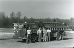
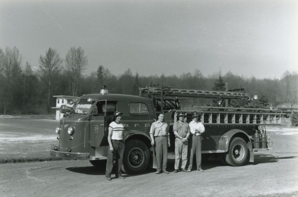
Burnaby Fire Department trainees at Confederation Park
https://search.heritageburnaby.ca/link/museumdescription1537
- Repository
- Burnaby Village Museum
- Date
- 1956 (date of original)
- Collection/Fonds
- Burnaby Village Museum Photograph collection
- Description Level
- Item
- Physical Description
- 1 photograph : b&w ; 10 x 15 cm print
- Scope and Content
- Photograph of four unidentified Burnaby Fire Department trainees standing in front of a 1954 triple combination LaFrance fire engine at Confederation Park.
- Repository
- Burnaby Village Museum
- Collection/Fonds
- Burnaby Village Museum Photograph collection
- Description Level
- Item
- Physical Description
- 1 photograph : b&w ; 10 x 15 cm print
- Scope and Content
- Photograph of four unidentified Burnaby Fire Department trainees standing in front of a 1954 triple combination LaFrance fire engine at Confederation Park.
- Names
- Burnaby Fire Department
- Accession Code
- BV998.31.19
- Access Restriction
- Restricted access
- Reproduction Restriction
- May be restricted by third party rights
- Date
- 1956 (date of original)
- Media Type
- Photograph
- Historic Neighbourhood
- Capitol Hill (Historic Neighbourhood)
- Planning Study Area
- Capitol Hill Area
- Scan Resolution
- 600
- Scan Date
- 02-Jun-09
- Scale
- 100
- Notes
- Title based on contents of photograph
- Typed sticker on verso of photograph reads: "Trainees (1956) with 1954/ Triple Combination La-/ France fire engine at/ Confederation Park."
- Address sticker on verso of photograph reads: "MR & MRS F BLAKE 4165 Pandora Street Burnaby BC Canada V5C 2B2"
Images
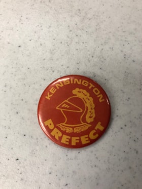
Button
https://search.heritageburnaby.ca/link/museumartifact90561
- Repository
- Burnaby Village Museum
- Accession Code
- BV020.33.4
- Description
- Red and Yellow button with a metal backing and pin fastener. A yellow image of a closed medival knight's helmet is in the centre of the button with "Kensington" (top) "Prefect" (bottom) around the image of the helmet.
- Object History
- From Kensington Junior Secondary SChool in the mid-1970s.
- Category
- 08. Communication Artifacts
- Classification
- Ceremonial Artifacts - - Organizational Objects
- Object Term
- Button, Promotional
- Colour
- Red
- Yellow
- Subjects
- Events - Competitions
- Sports
- Historic Neighbourhood
- Capitol Hill (Historic Neighbourhood)
- Planning Study Area
- Parkcrest-Aubrey Area
Images

Button
https://search.heritageburnaby.ca/link/museumartifact90562
- Repository
- Burnaby Village Museum
- Accession Code
- BV020.33.5
- Description
- Yellow and red button with a metal backing and pin fastener. A red image of a closed medival knight's helmet is in the centre of the button with "Kensington" (top) "Crusaders" (bottom) around the image of the helmet.
- Object History
- From Kensington Junior Secondary School in the mid-1970s.
- Category
- 08. Communication Artifacts
- Classification
- Ceremonial Artifacts - - Organizational Objects
- Object Term
- Button, Promotional
- Colour
- Yellow
- Red
- Subjects
- Events - Competitions
- Sports
- Historic Neighbourhood
- Capitol Hill (Historic Neighbourhood)
- Planning Study Area
- Parkcrest-Aubrey Area
Images
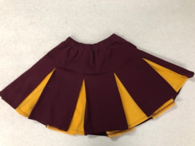
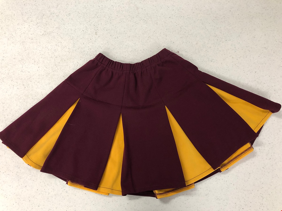
Cheerleading Skirt
https://search.heritageburnaby.ca/link/museumartifact90558
- Repository
- Burnaby Village Museum
- Accession Code
- BV020.33.1
- Description
- Polyester maroon and yellow pleated cheerleading skirt, with an elastic waistband. From Burnaby North High School.
- Object History
- This skirt was worn in the late 1970s by cheerleaders at Burnaby North High School.
- Category
- 03. Personal Artifacts
- Classification
- Clothing - - Main Garments
- Object Term
- Skirt
- Colour
- Maroon
- Yellow
- Historic Neighbourhood
- Capitol Hill (Historic Neighbourhood)
- Planning Study Area
- Capitol Hill Area
Images

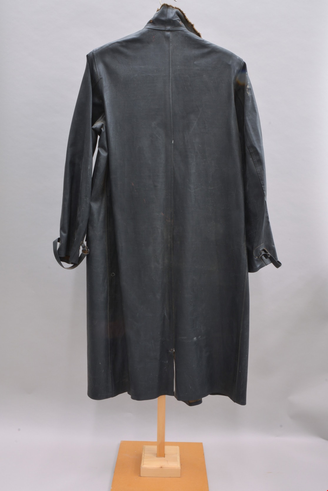
coat
https://search.heritageburnaby.ca/link/museumartifact39321
- Repository
- Burnaby Village Museum
- Accession Code
- BV998.57.1
- Description
- Black raincoat, man's; "Miner Black Diamond"; knee-length, rubber-coated; two front pockets, flap closure; collar lined with brown corduroy; rubber outside with round red emblem with rope motif border and black diamond at centre with "Miner Black Diamond" around outside; front closure is five large hooks-and-eyes, metal; sleeves have buckle closures; back of coat at bottom has 6" slit in centre. Black marker inside below collar lists "F.H. ESHELBY/ 11 FELL AVENUE".
- Object History
- Raincoat that belonged to Frank Eshelby. Frank Eshelby (1895-1974) married Annie Perrey (1896-1976) in London in 1920. The family moved to Capitol Hill in 1922 after investing in a couple of $5 lots on North Fell Avenue. The couple had two daughters: Winnifred in 1923 and Grace. The Eshelby's were longtime Burnaby residents. The raincoat was given to Frank by the Corporation of the District of Burnaby for cutting wood as a way to work off his unpaid taxes.
- Measurements
- height: 122.5 cm width: 60 cm
- Maker
- Miner Black Diamond
- Historic Neighbourhood
- Capitol Hill (Historic Neighbourhood)
Images


Confederation Park's new playground
https://search.heritageburnaby.ca/link/museumdescription1088
- Repository
- Burnaby Village Museum
- Date
- 1927
- Collection/Fonds
- Burnaby Village Museum Photograph collection
- Description Level
- Item
- Physical Description
- 1 photograph : sepia ; 19 x 23.5 cm
- Scope and Content
- Photograph of a large gathering of adults and children at Confederation Park for the opening ceremony for the new playground. A man on a pedestal is speaking and a crowd of people are surrounding him. There are six women in front of the gazebo wearing tags attached to the front of their dresses tha…
- Repository
- Burnaby Village Museum
- Collection/Fonds
- Burnaby Village Museum Photograph collection
- Description Level
- Item
- Physical Description
- 1 photograph : sepia ; 19 x 23.5 cm
- Scope and Content
- Photograph of a large gathering of adults and children at Confederation Park for the opening ceremony for the new playground. A man on a pedestal is speaking and a crowd of people are surrounding him. There are six women in front of the gazebo wearing tags attached to the front of their dresses that spell out "CANADA". There are three dogs in the foreground playing, and a Union Jack is flying in the upper right corner of the photograph.
- Subjects
- Recreational Devices - Playgrounds
- Geographic Features - Parks
- Persons - Crowds
- Events - Openings
- Geographic Access
- Confederation Park
- Willingdon Avenue
- Street Address
- 250 Willingdon Avenue
- Accession Code
- HV972.51.15
- Access Restriction
- No restrictions
- Reproduction Restriction
- No known restrictions
- Date
- 1927
- Media Type
- Photograph
- Historic Neighbourhood
- Capitol Hill (Historic Neighbourhood)
- Planning Study Area
- Capitol Hill Area
- Scan Resolution
- 600
- Scan Date
- 2023-04-04
- Photographer
- Charlton and Rathburn
- Notes
- Title based on contents of photograph
- Embossed inscription beneath photograph reads: "Charlton and Rathburn. / Vancouver. B.C."
- Handwritten inscription on verso of photograph reads: "Playground opening / Confederation Park / opening of Playground / Confederation Park / about 1927 / JCD on platform speaking"
- 1 b&w copy print accompanying
Images

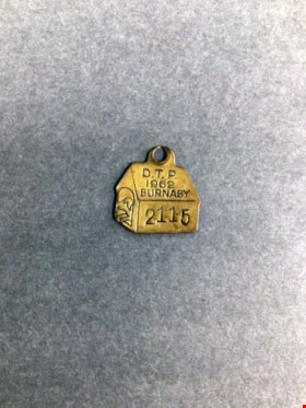
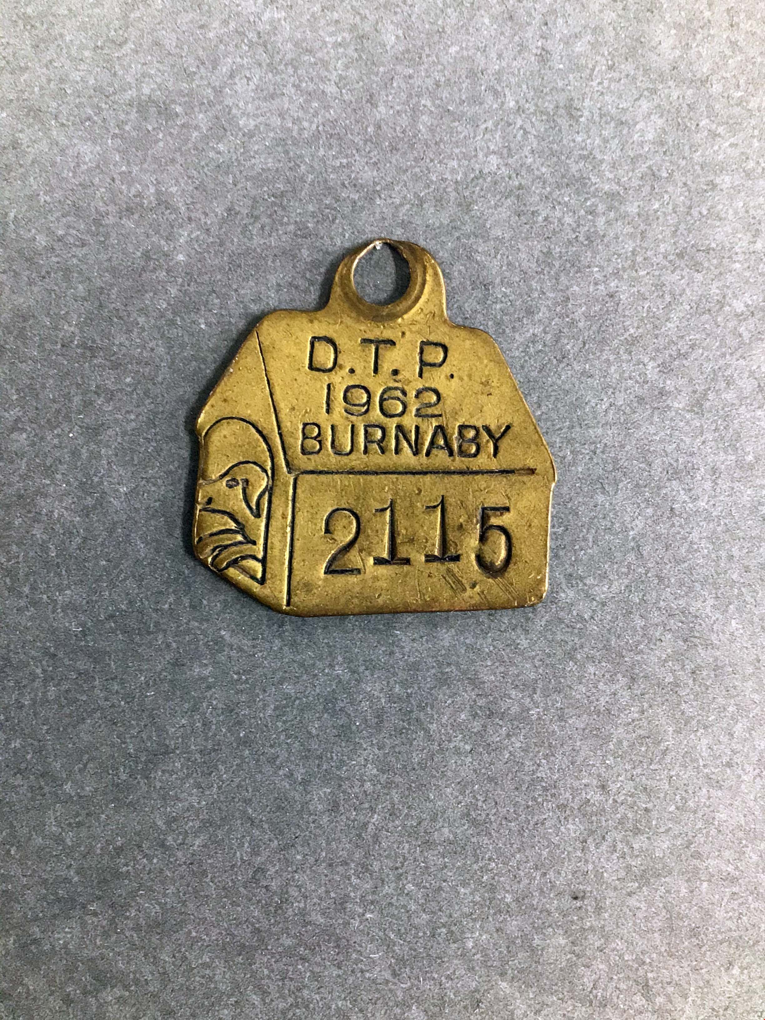
dog tag
https://search.heritageburnaby.ca/link/museumartifact91530
- Repository
- Burnaby Village Museum
- Accession Code
- BV022.5.1
- Description
- A small dog tag in the shape of a cartoon dog house. There is a sketch of a cartoon dog sitting in the entrance of the house, and the tag details are etched into the "roof" and "side" of the dog house.
- Object History
- The owner of the dog who wore this tag is Bernice Bell (nee Cashato) who lived in Burnaby with her parents. Her father, Joe Cashato, worked for the Engineering department of the City of Burnaby.
- Category
- 08. Communication Artifacts
- Classification
- Documentary Artifacts - - Other Documents
- Object Term
- Animal License
- Marks/Labels
- The label etched into the tag reads: "D.T.P 1962 Burnaby" followed by the number 2115
- Colour
- Bronze
- Measurements
- height: 3.5 cm width: 3.2 cm
- Historic Neighbourhood
- Capitol Hill (Historic Neighbourhood)
- Planning Study Area
- Capitol Hill Area
Images
![Emerson Doran and Murdoch McMurray delivering cordwood, [1925] (date of original), copied 1976 thumbnail](/media/hpo/_Data/_BVM_Images//1976/1976_0041_0001_001.jpg?width=280)
Emerson Doran and Murdoch McMurray delivering cordwood
https://search.heritageburnaby.ca/link/museumdescription711
- Repository
- Burnaby Village Museum
- Date
- [1925] (date of original), copied 1976
- Collection/Fonds
- Burnaby Village Museum Photograph collection
- Description Level
- Item
- Physical Description
- 1 photograph : b&w ; 20.2 x 25.3 cm print
- Scope and Content
- Photograph of two men in work clothes and hats leaning against a truck loaded with bundled fire wood. An accompanying note identifies the photograph as: Emerson Doran and Murdoch McMurray who owned Edmonds Wood and Coal Yard situated at Kingsway and Edmonds. They are standing beside their TRAFFIC …
- Repository
- Burnaby Village Museum
- Collection/Fonds
- Burnaby Village Museum Photograph collection
- Description Level
- Item
- Physical Description
- 1 photograph : b&w ; 20.2 x 25.3 cm print
- Scope and Content
- Photograph of two men in work clothes and hats leaning against a truck loaded with bundled fire wood. An accompanying note identifies the photograph as: Emerson Doran and Murdoch McMurray who owned Edmonds Wood and Coal Yard situated at Kingsway and Edmonds. They are standing beside their TRAFFIC truck which is loaded with cordwood about to be hauled from the Capitol Hill School grounds to the Edmonds Street School for use in heating the school. Edmonds Wood Yard had a contract with the Burnaby schools at this time to supply cordwood.
- Geographic Access
- Holdom Avenue
- Street Address
- 350 Holdom Avenue
- Accession Code
- HV976.41.1
- Access Restriction
- No restrictions
- Reproduction Restriction
- May be restricted by third party rights
- Date
- [1925] (date of original), copied 1976
- Media Type
- Photograph
- Historic Neighbourhood
- Capitol Hill (Historic Neighbourhood)
- Planning Study Area
- Capitol Hill Area
- Scan Resolution
- 600
- Scan Date
- 2023-06-13
- Notes
- Title based on contents of photograph
Images
![Emerson Doran and Murdoch McMurray delivering cordwood, [1925] (date of original), copied 1976 thumbnail](/media/hpo/_Data/_BVM_Images//1976/1976_0041_0001_001.jpg)