Narrow Results By
Subject
- Academic Disciplines 3
- Accidents 1
- Accidents - Automobile Accidents
- Adornment 22
- Adornment - Lapel Pins 24
- Advertising Medium 43
- Advertising Medium - Business Cards 8
- Advertising Medium - Flyer 24
- Advertising Medium - Poster 1
- Advertising Medium - Signs and Signboards 29
- Aerial Photographs
- Agricultural Tools and Equipment 5

Canada Way
https://search.heritageburnaby.ca/link/archivedescription79957
- Repository
- City of Burnaby Archives
- Date
- September, 1976
- Collection/Fonds
- Burnaby Public Library Contemporary Visual Archive Project
- Description Level
- Item
- Physical Description
- 1 photograph : b&w ; 11 x 16 cm mounted on cardboard
- Scope and Content
- Photograph shows a view looking west along Canada Way, taken from Westminster Avenue.
- Repository
- City of Burnaby Archives
- Date
- September, 1976
- Collection/Fonds
- Burnaby Public Library Contemporary Visual Archive Project
- Physical Description
- 1 photograph : b&w ; 11 x 16 cm mounted on cardboard
- Description Level
- Item
- Record No.
- 556-522
- Access Restriction
- No restrictions
- Reproduction Restriction
- Reproduce for fair dealing purposes only
- Accession Number
- 2013-13
- Scope and Content
- Photograph shows a view looking west along Canada Way, taken from Westminster Avenue.
- Subjects
- Aerial Photographs
- Media Type
- Photograph
- Photographer
- Campbell, Peg
- Notes
- Scope note taken directly from BPL photograph description.
- 1 b&w copy negative : 10 x 12.5 cm accompanying
- Geographic Access
- Canada Way
- Westminster Avenue
- Planning Study Area
- Douglas-Gilpin Area
Images

![Vehicle accident on Canada Way, [2000] thumbnail](/media/hpo/_Data/_Archives_Images/_Unrestricted/535/535-2687.jpg?width=280)
Vehicle accident on Canada Way
https://search.heritageburnaby.ca/link/archivedescription97290
- Repository
- City of Burnaby Archives
- Date
- [2000]
- Collection/Fonds
- Burnaby NewsLeader photograph collection
- Description Level
- Item
- Physical Description
- 1 photograph (tiff) : col.
- Scope and Content
- Photograph of an unidentified Burnaby RCMP officer standing on the road by a van that collided with a hydro pole at Canada Way and Morley Street. The pole is under the white van, which also dragged down lights and live wires.
- Repository
- City of Burnaby Archives
- Date
- [2000]
- Collection/Fonds
- Burnaby NewsLeader photograph collection
- Physical Description
- 1 photograph (tiff) : col.
- Description Level
- Item
- Record No.
- 535-2687
- Access Restriction
- No restrictions
- Reproduction Restriction
- No restrictions
- Accession Number
- 2018-12
- Scope and Content
- Photograph of an unidentified Burnaby RCMP officer standing on the road by a van that collided with a hydro pole at Canada Way and Morley Street. The pole is under the white van, which also dragged down lights and live wires.
- Media Type
- Photograph
- Photographer
- Bartel, Mario
- Notes
- Title based on caption
- Collected by editorial for use in a September 2000 issue of the Burnaby NewsLeader
- Caption from metadata: "A Burnaby RCMP officer keeps a safe distance after a van collided with a hydro pole on Canada Way at Morley, dragging down a couple of light standards and live wires. The road was closed, and power to the surrounding area was out for a number of hours."
- Geographic Access
- Canada Way
- Morley Street
- Historic Neighbourhood
- Burnaby Lake (Historic Neighbourhood)
- Planning Study Area
- Lakeview-Mayfield Area
Images
![Vehicle accident on Canada Way, [2000] thumbnail](/media/hpo/_Data/_Archives_Images/_Unrestricted/535/535-2687.jpg)
![Aerial photograph of the Burnaby Village area, [1946] (date of original), copied 1991 thumbnail](/media/hpo/_Data/_Archives_Images/_Unrestricted/370/370-532.jpg?width=280)
Aerial photograph of the Burnaby Village area
https://search.heritageburnaby.ca/link/archivedescription37945
- Repository
- City of Burnaby Archives
- Date
- [1946] (date of original), copied 1991
- Collection/Fonds
- Burnaby Historical Society fonds
- Description Level
- Item
- Physical Description
- 1 photograph : b&w ; 3.5 x 4.4 cm print on contact sheet 20.5 x 26.7 cm
- Scope and Content
- Aerial photograph of the Sperling Avenue/Douglas Road Burnaby Village area.
- Repository
- City of Burnaby Archives
- Date
- [1946] (date of original), copied 1991
- Collection/Fonds
- Burnaby Historical Society fonds
- Subseries
- Burnaby Image Bank subseries
- Physical Description
- 1 photograph : b&w ; 3.5 x 4.4 cm print on contact sheet 20.5 x 26.7 cm
- Description Level
- Item
- Record No.
- 370-532
- Access Restriction
- No restrictions
- Reproduction Restriction
- No known restrictions
- Accession Number
- BHS1999-03
- Scope and Content
- Aerial photograph of the Sperling Avenue/Douglas Road Burnaby Village area.
- Subjects
- Aerial Photographs
- Media Type
- Photograph
- Notes
- Title based on contents of photograph
- 1 b&w copy negative accompanying
- Negative has a pink cast
- Geographic Access
- Douglas Road
- Sperling Avenue
- Canada Way
- Historic Neighbourhood
- Burnaby Lake (Historic Neighbourhood)
Images
![Aerial photograph of the Burnaby Village area, [1946] (date of original), copied 1991 thumbnail](/media/hpo/_Data/_Archives_Images/_Unrestricted/370/370-532.jpg)
![Car Accident, [1937 or 1938] (date of original), copied 1991 thumbnail](/media/hpo/_Data/_Archives_Images/_Unrestricted/370/370-548.jpg?width=280)
Car Accident
https://search.heritageburnaby.ca/link/archivedescription37961
- Repository
- City of Burnaby Archives
- Date
- [1937 or 1938] (date of original), copied 1991
- Collection/Fonds
- Burnaby Historical Society fonds
- Description Level
- Item
- Physical Description
- 1 photograph : b&w ; 3.3 x 2.5 cm print on contact sheet 20.6 x 26.1 cm
- Scope and Content
- Photograph of a damaged car belonging to Bob Pontifex, after an accident at Sperling Avenue and Douglas Road.
- Repository
- City of Burnaby Archives
- Date
- [1937 or 1938] (date of original), copied 1991
- Collection/Fonds
- Burnaby Historical Society fonds
- Subseries
- Burnaby Image Bank subseries
- Physical Description
- 1 photograph : b&w ; 3.3 x 2.5 cm print on contact sheet 20.6 x 26.1 cm
- Description Level
- Item
- Record No.
- 370-548
- Access Restriction
- No restrictions
- Reproduction Restriction
- No known restrictions
- Accession Number
- BHS1999-03
- Scope and Content
- Photograph of a damaged car belonging to Bob Pontifex, after an accident at Sperling Avenue and Douglas Road.
- Subjects
- Accidents - Automobile Accidents
- Media Type
- Photograph
- Notes
- Title based on contents of photograph
- 1 b&w copy negative accompanying
- Geographic Access
- Douglas Road
- Sperling Avenue
- Canada Way
- Historic Neighbourhood
- Burnaby Lake (Historic Neighbourhood)
Images
![Car Accident, [1937 or 1938] (date of original), copied 1991 thumbnail](/media/hpo/_Data/_Archives_Images/_Unrestricted/370/370-548.jpg)

Highway No. 1
https://search.heritageburnaby.ca/link/archivedescription79950
- Repository
- City of Burnaby Archives
- Date
- September, 1976
- Collection/Fonds
- Burnaby Public Library Contemporary Visual Archive Project
- Description Level
- Item
- Physical Description
- 1 photograph : b&w ; 11 x 16 cm mounted on cardboard
- Scope and Content
- Photograph shows a view of the No. 1 Highway looking northwest from Sprott Street overpass.
- Repository
- City of Burnaby Archives
- Date
- September, 1976
- Collection/Fonds
- Burnaby Public Library Contemporary Visual Archive Project
- Physical Description
- 1 photograph : b&w ; 11 x 16 cm mounted on cardboard
- Description Level
- Item
- Record No.
- 556-520
- Access Restriction
- No restrictions
- Reproduction Restriction
- Reproduce for fair dealing purposes only
- Accession Number
- 2013-13
- Scope and Content
- Photograph shows a view of the No. 1 Highway looking northwest from Sprott Street overpass.
- Subjects
- Aerial Photographs
- Media Type
- Photograph
- Photographer
- Salmon, Stu
- Notes
- Scope note taken directly from BPL photograph description.
- 1 b&w copy negative : 10 x 12.5 cm accompanying
- Geographic Access
- Trans Canada Highway
- Historic Neighbourhood
- Burnaby Lake (Historic Neighbourhood)
- Planning Study Area
- Douglas-Gilpin Area
Images


Highway No. 1
https://search.heritageburnaby.ca/link/archivedescription79977
- Repository
- City of Burnaby Archives
- Date
- September 23, 1976
- Collection/Fonds
- Burnaby Public Library Contemporary Visual Archive Project
- Description Level
- Item
- Physical Description
- 1 photograph : b&w ; 11 x 16 cm mounted on cardboard
- Scope and Content
- Photograph shows a view of underdeveloped area and the No. 1 Highway looking northwest from the Sperling Overpass with Capitol Hill in the background.
- Repository
- City of Burnaby Archives
- Date
- September 23, 1976
- Collection/Fonds
- Burnaby Public Library Contemporary Visual Archive Project
- Physical Description
- 1 photograph : b&w ; 11 x 16 cm mounted on cardboard
- Description Level
- Item
- Record No.
- 556-533
- Access Restriction
- No restrictions
- Reproduction Restriction
- Reproduce for fair dealing purposes only
- Accession Number
- 2013-13
- Scope and Content
- Photograph shows a view of underdeveloped area and the No. 1 Highway looking northwest from the Sperling Overpass with Capitol Hill in the background.
- Subjects
- Aerial Photographs
- Media Type
- Photograph
- Photographer
- Campbell, Peg
- Notes
- Scope note taken directly from BPL photograph description.
- 1 b&w copy negative : 10 x 12.5 cm accompanying
- Geographic Access
- Trans Canada Highway
- Planning Study Area
- Ardingley-Sprott Area
Images


Stormont Overpass
https://search.heritageburnaby.ca/link/archivedescription45376
- Repository
- City of Burnaby Archives
- Date
- August 1978
- Collection/Fonds
- Columbian Newspaper collection
- Description Level
- Item
- Physical Description
- 1 photograph : b&w ; 12.5 x 24 cm
- Scope and Content
- Aerial photograph of Stormont Overpass which would provide a direct link from the Trans Canada Highway (previously named the 401 Freeway) to the Lougheed Highway and Simon Fraser University. This was taken when the excavation work was completed, and grading and paving still need to be done.
- Repository
- City of Burnaby Archives
- Date
- August 1978
- Collection/Fonds
- Columbian Newspaper collection
- Physical Description
- 1 photograph : b&w ; 12.5 x 24 cm
- Description Level
- Item
- Record No.
- 480-271
- Access Restriction
- No restrictions
- Reproduction Restriction
- No restrictions
- Accession Number
- 2003-02
- Scope and Content
- Aerial photograph of Stormont Overpass which would provide a direct link from the Trans Canada Highway (previously named the 401 Freeway) to the Lougheed Highway and Simon Fraser University. This was taken when the excavation work was completed, and grading and paving still need to be done.
- Media Type
- Photograph
- Photographer
- Hodge, Craig
- Notes
- Title based on contents of photograph
- Note in pencil on verso of photograph reads: "Altair Aviation / photo by / Craig Hodge"
- Geographic Access
- Cariboo Road
- Gaglardi Way
- Trans Canada Highway
- Historic Neighbourhood
- Burquitlam (Historic Neighbourhood)
- Planning Study Area
- Burnaby Lake Area
- Cameron Area
Images


Stormont Overpass
https://search.heritageburnaby.ca/link/archivedescription45377
- Repository
- City of Burnaby Archives
- Date
- August 1978
- Collection/Fonds
- Columbian Newspaper collection
- Description Level
- Item
- Physical Description
- 1 photograph : b&w ; 16.5 x 24 cm
- Scope and Content
- Aerial photograph of Stormont Overpass which would provide a direct link from the 401 Freeway to the Lougheed Highway and Simon Fraser University. This was taken when the excavation work was completed, and grading and paving still need to be done.
- Repository
- City of Burnaby Archives
- Date
- August 1978
- Collection/Fonds
- Columbian Newspaper collection
- Physical Description
- 1 photograph : b&w ; 16.5 x 24 cm
- Description Level
- Item
- Record No.
- 480-272
- Access Restriction
- No restrictions
- Reproduction Restriction
- No restrictions
- Accession Number
- 2003-02
- Scope and Content
- Aerial photograph of Stormont Overpass which would provide a direct link from the 401 Freeway to the Lougheed Highway and Simon Fraser University. This was taken when the excavation work was completed, and grading and paving still need to be done.
- Media Type
- Photograph
- Photographer
- Hodge, Craig
- Notes
- Title based on contents of photograph
- Newspaper clipping attached to verso of photograph reads: "After six years, work on the Stormont interchange in Burnaby is only a few weeks from completion. The huge clover-leaf junction of Gaglardi Way and the Freeway is on the top left-hand corner, with Gaglardi Way approaching from the bottom right where a bridge has been completed over the Burlington Northern tracks. An embankment linking that bridge with one over the Brunette River awaits only a layer of tarmac, and a path has been cleared through the woods to link up with the clover-leaf. The present access to the Freeway is along the road running from the left to right across the middle of the picture. The interchange will open next month."
- Note in pencil on verso of photograph reads: "Altair Aviation / photo by / Craig Hodge"
- Geographic Access
- Cariboo Road
- Gaglardi Way
- Trans Canada Highway
- Historic Neighbourhood
- Burquitlam (Historic Neighbourhood)
- Planning Study Area
- Burnaby Lake Area
- Cameron Area
Images

![Stormont Overpass, [1978] thumbnail](/media/hpo/_Data/_Archives_Images/_Unrestricted/480/480-275.jpg?width=280)
Stormont Overpass
https://search.heritageburnaby.ca/link/archivedescription45380
- Repository
- City of Burnaby Archives
- Date
- [1978]
- Collection/Fonds
- Columbian Newspaper collection
- Description Level
- Item
- Physical Description
- 1 photograph : b&w ; 16 x 24 cm
- Scope and Content
- Aerial photograph of Stormont Overpass which would provide a direct link from the Trans Canada Highway (previously named the 401 Freeway) to the Lougheed Highway and Simon Fraser University. This was taken when the excavation work was completed, and paving still need to be done.
- Repository
- City of Burnaby Archives
- Date
- [1978]
- Collection/Fonds
- Columbian Newspaper collection
- Physical Description
- 1 photograph : b&w ; 16 x 24 cm
- Description Level
- Item
- Record No.
- 480-275
- Access Restriction
- No restrictions
- Reproduction Restriction
- No restrictions
- Accession Number
- 2003-02
- Scope and Content
- Aerial photograph of Stormont Overpass which would provide a direct link from the Trans Canada Highway (previously named the 401 Freeway) to the Lougheed Highway and Simon Fraser University. This was taken when the excavation work was completed, and paving still need to be done.
- Media Type
- Photograph
- Photographer
- King, Basil
- Notes
- Title based on contents of photograph
- Note on verso of photograph reads: "One of the biggest Highways"
- Geographic Access
- Cariboo Road
- Gaglardi Way
- Trans Canada Highway
- Historic Neighbourhood
- Burquitlam (Historic Neighbourhood)
- Planning Study Area
- Burnaby Lake Area
- Cameron Area
Images
![Stormont Overpass, [1978] thumbnail](/media/hpo/_Data/_Archives_Images/_Unrestricted/480/480-275.jpg)
Aerial photograph of Burnaby
https://search.heritageburnaby.ca/link/archivedescription84903
- Repository
- City of Burnaby Archives
- Date
- 1963
- Collection/Fonds
- Allan Amundsen collection
- Description Level
- Item
- Physical Description
- 1 photograph : b&w ; 22.5 x 22.5 cm
- Scope and Content
- Aerial photograph of Burnaby with the Trans Canada Highway running through and the Forest Lawn Cemetery to the south.
- Repository
- City of Burnaby Archives
- Date
- 1963
- Collection/Fonds
- Allan Amundsen collection
- Physical Description
- 1 photograph : b&w ; 22.5 x 22.5 cm
- Description Level
- Item
- Record No.
- 561-024
- Access Restriction
- In Archives only
- Reproduction Restriction
- No reproduction permitted
- Accession Number
- 2014-08
- Scope and Content
- Aerial photograph of Burnaby with the Trans Canada Highway running through and the Forest Lawn Cemetery to the south.
- Subjects
- Aerial Photographs
- Media Type
- Photograph
- Photographer
- Province of British Columbia
- Notes
- Title based on contents of photograph
- This photo is indentified as BC5062:27 and connects with B.C. air photograph BC5061:26 to the east
- Historic Neighbourhood
- Burnaby Lake (Historic Neighbourhood)
- Planning Study Area
- Douglas-Gilpin Area
- Ardingley-Sprott Area
- Dawson-Delta Area
Aerial photograph of Burnaby
https://search.heritageburnaby.ca/link/archivedescription84907
- Repository
- City of Burnaby Archives
- Date
- 1963
- Collection/Fonds
- Allan Amundsen collection
- Description Level
- Item
- Physical Description
- 1 photograph : b&w ; 22.5 x 22.5 cm
- Scope and Content
- Aerial photograph of Burnaby with the Trans Canada Highway running from through and Burnaby Lake in the south east corner.
- Repository
- City of Burnaby Archives
- Date
- 1963
- Collection/Fonds
- Allan Amundsen collection
- Physical Description
- 1 photograph : b&w ; 22.5 x 22.5 cm
- Description Level
- Item
- Record No.
- 561-025
- Access Restriction
- In Archives only
- Reproduction Restriction
- No reproduction permitted
- Accession Number
- 2014-08
- Scope and Content
- Aerial photograph of Burnaby with the Trans Canada Highway running from through and Burnaby Lake in the south east corner.
- Subjects
- Aerial Photographs
- Media Type
- Photograph
- Photographer
- Province of British Columbia
- Notes
- Title based on contents of photograph
- This photo is indentified as BC5062:26 and connects with B.C. air photograph BC5062:27 to the west and B.C. air photograph BC5062:25 to the east
- Historic Neighbourhood
- Burnaby Lake (Historic Neighbourhood)
- Planning Study Area
- Douglas-Gilpin Area
- Ardingley-Sprott Area
- Burnaby Lake Area
Aerial photograph of Burnaby
https://search.heritageburnaby.ca/link/archivedescription84911
- Repository
- City of Burnaby Archives
- Date
- 1963
- Collection/Fonds
- Allan Amundsen collection
- Description Level
- Item
- Physical Description
- 1 photograph : b&w ; 22.5 x 22.5 cm
- Scope and Content
- Aerial photograph of Burnaby with Lougheed Highway running west to east through the middle of the photograph and the Trans Canada Highway in the lower left segment.
- Repository
- City of Burnaby Archives
- Date
- 1963
- Collection/Fonds
- Allan Amundsen collection
- Physical Description
- 1 photograph : b&w ; 22.5 x 22.5 cm
- Description Level
- Item
- Record No.
- 561-029
- Access Restriction
- In Archives only
- Reproduction Restriction
- No reproduction permitted
- Accession Number
- 2014-08
- Scope and Content
- Aerial photograph of Burnaby with Lougheed Highway running west to east through the middle of the photograph and the Trans Canada Highway in the lower left segment.
- Subjects
- Aerial Photographs
- Media Type
- Photograph
- Photographer
- Province of British Columbia
- Notes
- Title based on contents of photograph
- This photo is indentified as BC5062:22 and connects with B.C. air photograph BC5062:23 to the west and B.C. air photograph BC5062:21
- Historic Neighbourhood
- Lozells (Historic Neighbourhood)
- Burquitlam (Historic Neighbourhood)
- Planning Study Area
- Lake City Area
- Government Road Area
- Burnaby Lake Area
- Lyndhurst Area
- Cariboo-Armstrong Area
Aerial photograph of Burnaby
https://search.heritageburnaby.ca/link/archivedescription84913
- Repository
- City of Burnaby Archives
- Date
- 1963
- Collection/Fonds
- Allan Amundsen collection
- Description Level
- Item
- Physical Description
- 1 photograph : b&w ; 22.5 x 22.5 cm
- Scope and Content
- Aerial photograph of East Burnaby up to North Road and south of the Trans Canada Highway.
- Repository
- City of Burnaby Archives
- Date
- 1963
- Collection/Fonds
- Allan Amundsen collection
- Physical Description
- 1 photograph : b&w ; 22.5 x 22.5 cm
- Description Level
- Item
- Record No.
- 561-031
- Access Restriction
- In Archives only
- Reproduction Restriction
- No reproduction permitted
- Accession Number
- 2014-08
- Scope and Content
- Aerial photograph of East Burnaby up to North Road and south of the Trans Canada Highway.
- Subjects
- Aerial Photographs
- Media Type
- Photograph
- Photographer
- Province of British Columbia
- Notes
- Title based on contents of photograph
- This photo is indentified as BC5062:70 and connects with B.C. air photograph BC5062:21 to the west and BC5062:71 to the east
- Historic Neighbourhood
- East Burnaby (Historic Neighbourhood)
- Planning Study Area
- Cameron Area
- Cariboo-Armstrong Area
Aerial photograph of Burnaby Lake Area
https://search.heritageburnaby.ca/link/archivedescription84908
- Repository
- City of Burnaby Archives
- Date
- 1963
- Collection/Fonds
- Allan Amundsen collection
- Description Level
- Item
- Physical Description
- 1 photograph : b&w ; 22.5 x 22.5 cm
- Scope and Content
- Aerial photograph of Burnaby with Lougheed Highway in the north west corner, the Trans Canada Highway in the south east corner and Burnaby Lake appearing from the west.
- Repository
- City of Burnaby Archives
- Date
- 1963
- Collection/Fonds
- Allan Amundsen collection
- Physical Description
- 1 photograph : b&w ; 22.5 x 22.5 cm
- Description Level
- Item
- Record No.
- 561-026
- Access Restriction
- In Archives only
- Reproduction Restriction
- No reproduction permitted
- Accession Number
- 2014-08
- Scope and Content
- Aerial photograph of Burnaby with Lougheed Highway in the north west corner, the Trans Canada Highway in the south east corner and Burnaby Lake appearing from the west.
- Subjects
- Aerial Photographs
- Media Type
- Photograph
- Photographer
- Province of British Columbia
- Notes
- Title based on contents of photograph
- This photo is indentified as BC5062:25 and connects with B.C. air photograph BC5062:26 to the west and B.C. air photograph BC5062:24 to the east
- Historic Neighbourhood
- Burnaby Lake (Historic Neighbourhood)
- Lozells (Historic Neighbourhood)
- Planning Study Area
- Douglas-Gilpin Area
- Sperling-Broadway Area
- Government Road Area
- Burnaby Lake Area

Burnaby Lake rowing course dredging
https://search.heritageburnaby.ca/link/archivedescription38303
- Repository
- City of Burnaby Archives
- Date
- 1971
- Collection/Fonds
- Burnaby Historical Society fonds
- Description Level
- Item
- Physical Description
- 1 photograph : col. ; 12.5 x 18 cm
- Scope and Content
- Aerial photograph of the Burnaby Lake rowing course being dredged in 1971, in preparation for the 1973 Canada Summer Games.
- Repository
- City of Burnaby Archives
- Date
- 1971
- Collection/Fonds
- Burnaby Historical Society fonds
- Subseries
- Photographs subseries
- Physical Description
- 1 photograph : col. ; 12.5 x 18 cm
- Description Level
- Item
- Record No.
- 400-001
- Access Restriction
- No restrictions
- Reproduction Restriction
- Reproduce for fair dealing purposes only
- Accession Number
- BHS2007-04
- Scope and Content
- Aerial photograph of the Burnaby Lake rowing course being dredged in 1971, in preparation for the 1973 Canada Summer Games.
- Media Type
- Photograph
- Notes
- Title based on contents of photograph
- Geographic Access
- Roberts Street
- Burnaby Lake
- Street Address
- 6871 Roberts Street
- Historic Neighbourhood
- Burnaby Lake (Historic Neighbourhood)
- Planning Study Area
- Burnaby Lake Area
Images


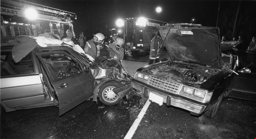
Car accident scene
https://search.heritageburnaby.ca/link/archivedescription79975
- Repository
- City of Burnaby Archives
- Date
- February 5, 1997
- Collection/Fonds
- Burnaby NewsLeader photograph collection
- Description Level
- Item
- Physical Description
- 1 photograph : b&w ; 12.5 x 22.5 cm
- Scope and Content
- Photograph of a head on crash on Canada Way involving two cars and rescue workers attending the scene.
- Repository
- City of Burnaby Archives
- Date
- February 5, 1997
- Collection/Fonds
- Burnaby NewsLeader photograph collection
- Physical Description
- 1 photograph : b&w ; 12.5 x 22.5 cm
- Description Level
- Item
- Record No.
- 535-0589
- Access Restriction
- No restrictions
- Reproduction Restriction
- No reproduction permitted
- Accession Number
- 2012-11
- Scope and Content
- Photograph of a head on crash on Canada Way involving two cars and rescue workers attending the scene.
- Subjects
- Accidents - Automobile Accidents
- Public Services - Policing
- Occupations - Fire Fighters
- Transportation - Fire Trucks
- Media Type
- Photograph
- Photographer
- Bartel, Mario
- Notes
- Title based on contents of photograph
- Note in black ink on recto of photograph reads: "Mario Bby 281 / 76% BbyNW 3 02/05"
- Trim marks and/or reproduction instructions on recto (scan is cropped)
Images
![The Fair Haven, [between 1950 and 1957] thumbnail](/media/Hpo/_Data/_Archives_Images/_Unrestricted/251/305-001.jpg?width=280)
The Fair Haven
https://search.heritageburnaby.ca/link/archivedescription36597
- Repository
- City of Burnaby Archives
- Date
- [between 1950 and 1957]
- Collection/Fonds
- Burnaby Historical Society fonds
- Description Level
- Item
- Physical Description
- 1 photograph : col. postcard ; 9 x 14 cm
- Scope and Content
- Aerial photographic postcard of "the Fair Haven," a group of United Church homes for Senior Citizens. The road in the foreground is Rumble Street, and the long road to the right is Sussex Avenue. The small forest behind "the Fair Haven" is the David Gary Park.
- Repository
- City of Burnaby Archives
- Date
- [between 1950 and 1957]
- Collection/Fonds
- Burnaby Historical Society fonds
- Subseries
- Vera Jackson Pel subseries
- Physical Description
- 1 photograph : col. postcard ; 9 x 14 cm
- Description Level
- Item
- Record No.
- 305-001
- Access Restriction
- No restrictions
- Reproduction Restriction
- Reproduce for fair dealing purposes only
- Accession Number
- BHS1992-46
- Scope and Content
- Aerial photographic postcard of "the Fair Haven," a group of United Church homes for Senior Citizens. The road in the foreground is Rumble Street, and the long road to the right is Sussex Avenue. The small forest behind "the Fair Haven" is the David Gary Park.
- Subjects
- Aerial Photographs
- Documentary Artifacts - Postcards
- Buildings - Residential - Seniors Housing
- Names
- Fair Haven
- Media Type
- Photograph
- Notes
- Typewritten note on verso of postcard reads: "AERIAL VIEW/ 'The Fairhaven', Burnaby BC / United Church Homes for Senior Citizens / 4341 Rumble St., Burnaby, BC"
- Handwritten note on verso of postcard reads: ""The road in the foreground is Rumble Street. The long road to the right is Sussex Avenue. The road, going up, on the left, barely visible is McKay Avenue = lower corner. Behind Fair Haven is the future David Gary Park cleared in the late 1950's - then more trees were felled in October 1962 with Hurricane Freda (blown over, uprooted trees) that left the park as it is today in 1993. The top row of little (5) white cottages were moved from the N.W. corner of Willingdon and Kingsway where Old Orchard Mall is now - they were part of Old Orchard Auto Villas, the first Fair Havens. Note: All cottages on right side of Lodge have been moved to Vancouver Island in 1991 for Motel units - by barge."
- Printed on verso of postcard: "Traveltime product, made in Vancouver, Canada, by Grant-Mann Lithographers Ltd."
- Geographic Access
- Rumble Street
- Street Address
- 4341 Rumble Street
- Historic Neighbourhood
- Alta-Vista (Historic Neighbourhood)
- Planning Study Area
- Sussex-Nelson Area
Images
![The Fair Haven, [between 1950 and 1957] thumbnail](/media/Hpo/_Data/_Archives_Images/_Unrestricted/251/305-001.jpg)

Interview with Don Brown by Rod Fowler February 26, 1990 - Track 6
https://search.heritageburnaby.ca/link/oralhistory507
- Repository
- City of Burnaby Archives
- Date Range
- 1947-1954
- Length
- 00:05:44
- Summary
- This portion of the interview is about the paving and widening of Kingsway in 1953, the development along main roads, and the end of the Interurban tram system
- Repository
- City of Burnaby Archives
- Summary
- This portion of the interview is about the paving and widening of Kingsway in 1953, the development along main roads, and the end of the Interurban tram system
- Date Range
- 1947-1954
- Photo Info
- Royal Canadian Mounted Police Sergeant Don Brown, November 2, 1997. Item no. 535-0979
- Length
- 00:05:44
- Subjects
- Accidents - Automobile Accidents
- Transportation - Automobiles
- Transportation - Electric Railroads
- Interviewer
- Fowler, Rod
- Interview Date
- February 26, 1990
- Scope and Content
- Recording is of an interview with Don Brown, conducted by Rod Fowler. Don Brown was one of eleven participants interviewed as part of the SFU/Burnaby Centennial Committee's oral history series titled, "Voices of Burnaby". The interview is mainly about Don Brown’s description of the changes in Burnaby’s built and natural landscapes and socioeconomic conditions, especially between 1947 and 1975, the strong impression made on him by those changes evident in the interview. He talks about his work and career as a police officer with the Burnaby Provincial Police and RCMP. The interview also details his involvement in Burnaby politics and volunteer community groups. To view “Narrow By” terms for each track expand this description and see “Notes”.
- Biographical Notes
- Donald Neil “Don” Brown was born in Birmingham, England May 4, 1919, and immigrated with his parents and siblings to Winnipeg in 1922. At the outbreak of WWII Don Brown left high school and enlisted in the 12th Field Company, Royal Canadian Engineers, serving six years in the army. Before going overseas he married Helen Birch in 1939. In 1947 Don Brown joined the B.C. Provincial Police which was absorbed by the RCMP in 1950. He worked as a police officer in Burnaby from 1947 to 1954, and then was transferred to Ottawa (with a stop in Regina) for nine and a half years where he attended Carleton University to study forensics. In 1963 Don Brown was transferred back to Vancouver and bought and moved into a house on Watling Street in Burnaby where he still lived in 1990. Another transfer took him to Edmonton for five years, returning to Burnaby in 1975. Following retirement in 1980 with the rank of Supervisor and after 22 years in forensic laboratories, Don Brown started his own business as a private document examiner. Don Brown was active in Burnaby politics, serving as Alderman from 1979-1985. He was also involved in many community groups including the South Burnaby Men’s Club, which he helped found in 1952, as well as active in the Burnaby Historical Society, and served on the Burnaby School Board, Burnaby Centennial Committee, and the Community College for the Retired. Don and Helen Brown had six children: Donna, Don, Gina, Patricia, Christopher and Susan. Don Brown died May 16, 2009.
- Total Tracks
- 14
- Total Length
- 01:35:07
- Interviewee Name
- Brown, Donald N. "Don"
- Interviewer Bio
- Rod Fowler returned to university as a mature student in the 1980s after working about twenty years in the field of economics and computerization in business in England, Europe and Western Canada. He graduated with a BA from SFU in both History and Sociology in 1987, his MA degree in Geography in 1989, and his PhD in Cultural Geography at SFU. He taught courses in Geography, Sociology, History and Canadian Studies at several Lower Mainland colleges, before becoming a full time member of the Geography Department at Kwantlen University College.
- Collection/Fonds
- SFU/Burnaby Centennial Committee fonds
- Transcript Available
- Transcript available
- Media Type
- Sound Recording
- Web Notes
- Interviews were digitized in 2015 allowing them to be accessible on Heritage Burnaby. The digitization project was initiated by the Community Heritage Commission with support from City of Burnaby Council.
Images

Audio Tracks
Track six of interview with Don Brown
Track six of interview with Don Brown
https://search.heritageburnaby.ca/media/hpo/_Data/_Archives_Oral_Histories/_Unrestricted/MSS187-016/MSS187-016_Track%206.mp3![Lenkurt Electric Company, [1957] thumbnail](/media/Hpo/_Data/_Archives_Images/_Unrestricted/001/099-001.jpg?width=280)
Lenkurt Electric Company
https://search.heritageburnaby.ca/link/archivedescription34690
- Repository
- City of Burnaby Archives
- Date
- [1957]
- Collection/Fonds
- Burnaby Historical Society fonds
- Description Level
- Item
- Physical Description
- 1 photograph : b&w ; 20.3 x 25.3 cm
- Scope and Content
- Photograph of aerial view of the Lenkurt Electric Company at 6960 Lougheed Highway (later renumbered 7018 Lougheed Highway). A sign on the top of the building reads, "Lenkurt." An information sheet from the Company Relation Division of Lenkurt attached to the back of the photograph reads, "Aerial…
- Repository
- City of Burnaby Archives
- Date
- [1957]
- Collection/Fonds
- Burnaby Historical Society fonds
- Subseries
- Photographs subseries
- Physical Description
- 1 photograph : b&w ; 20.3 x 25.3 cm
- Description Level
- Item
- Record No.
- 099-001
- Access Restriction
- No restrictions
- Reproduction Restriction
- Reproduce for fair dealing purposes only
- Accession Number
- BHS2007-04
- Scope and Content
- Photograph of aerial view of the Lenkurt Electric Company at 6960 Lougheed Highway (later renumbered 7018 Lougheed Highway). A sign on the top of the building reads, "Lenkurt." An information sheet from the Company Relation Division of Lenkurt attached to the back of the photograph reads, "Aerial view of a 34,000 square foot building including a 19,000 square foot extension to the existing 15,000 square foot plant of Lenkurt Electric Co. of Canada Ltd. in North Burnaby, B.C., as at May 10th, 1957. / The building is situated on 20 acres of land and faces north onto Lougheed Highway."
- Names
- Lenkurt Electric Company
- Media Type
- Photograph
- Photographer
- Commercial Illustrators Industrial Photographers
- Notes
- Title based on contents of photograph
- Stamp and annotation on back of photograph reads, "TA. 8817 / Commerical Illustrators / Industrial Photographers / 601 Denman St., Vancouver 5, B.C. / File No. 1080-1"
- Geographic Access
- Lougheed Highway
- Street Address
- 7018 Lougheed Highway
- Historic Neighbourhood
- Lozells (Historic Neighbourhood)
- Planning Study Area
- Government Road Area
Images
![Lenkurt Electric Company, [1957] thumbnail](/media/Hpo/_Data/_Archives_Images/_Unrestricted/001/099-001.jpg)
![Sidney Roofing and Paper Company, [1960] thumbnail](/media/Hpo/_Data/_Archives_Images/_Unrestricted/001/091-004.jpg?width=280)
Sidney Roofing and Paper Company
https://search.heritageburnaby.ca/link/archivedescription34679
- Repository
- City of Burnaby Archives
- Date
- [1960]
- Collection/Fonds
- Burnaby Historical Society fonds
- Description Level
- Item
- Physical Description
- 1 photograph : b&w ; 20.5 x 25.3 cm
- Scope and Content
- Aerial photograph of Sidney Roofing and Paper Company, South Burnaby.
- Repository
- City of Burnaby Archives
- Date
- [1960]
- Collection/Fonds
- Burnaby Historical Society fonds
- Subseries
- Photographs subseries
- Physical Description
- 1 photograph : b&w ; 20.5 x 25.3 cm
- Description Level
- Item
- Record No.
- 091-004
- Access Restriction
- No restrictions
- Reproduction Restriction
- Reproduce for fair dealing purposes only
- Accession Number
- BHS2007-04
- Scope and Content
- Aerial photograph of Sidney Roofing and Paper Company, South Burnaby.
- Media Type
- Photograph
- Photographer
- Graphic Industries Limited
- Notes
- Title based on contents of photograph
- Bottom of photo has the "Sidney Products" logo and reads, "Sidney Roofing & Paper Co. Ltd."
- Stamped on back of photograph: "Photo by: Graphic Industries Ltd. / File No. 3921-2 / Vancouver, Canada / PAcific 4174"
- Historic Neighbourhood
- Fraser Arm (Historic Neighbourhood)
- Planning Study Area
- Big Bend Area
Images
![Sidney Roofing and Paper Company, [1960] thumbnail](/media/Hpo/_Data/_Archives_Images/_Unrestricted/001/091-004.jpg)