Narrow Results By
Subject
- Academic Disciplines 3
- Accidents 1
- Accidents - Automobile Accidents 4
- Adornment 22
- Adornment - Lapel Pins
- Advertising Medium 43
- Advertising Medium - Business Cards 8
- Advertising Medium - Flyer 24
- Advertising Medium - Poster
- Advertising Medium - Signs and Signboards 29
- Aerial Photographs
- Agricultural Tools and Equipment 5
Aerial photograph of Burnaby
https://search.heritageburnaby.ca/link/archivedescription84903
- Repository
- City of Burnaby Archives
- Date
- 1963
- Collection/Fonds
- Allan Amundsen collection
- Description Level
- Item
- Physical Description
- 1 photograph : b&w ; 22.5 x 22.5 cm
- Scope and Content
- Aerial photograph of Burnaby with the Trans Canada Highway running through and the Forest Lawn Cemetery to the south.
- Repository
- City of Burnaby Archives
- Date
- 1963
- Collection/Fonds
- Allan Amundsen collection
- Physical Description
- 1 photograph : b&w ; 22.5 x 22.5 cm
- Description Level
- Item
- Record No.
- 561-024
- Access Restriction
- In Archives only
- Reproduction Restriction
- No reproduction permitted
- Accession Number
- 2014-08
- Scope and Content
- Aerial photograph of Burnaby with the Trans Canada Highway running through and the Forest Lawn Cemetery to the south.
- Subjects
- Aerial Photographs
- Media Type
- Photograph
- Photographer
- Province of British Columbia
- Notes
- Title based on contents of photograph
- This photo is indentified as BC5062:27 and connects with B.C. air photograph BC5061:26 to the east
- Historic Neighbourhood
- Burnaby Lake (Historic Neighbourhood)
- Planning Study Area
- Douglas-Gilpin Area
- Ardingley-Sprott Area
- Dawson-Delta Area
Aerial photograph of Burnaby
https://search.heritageburnaby.ca/link/archivedescription84907
- Repository
- City of Burnaby Archives
- Date
- 1963
- Collection/Fonds
- Allan Amundsen collection
- Description Level
- Item
- Physical Description
- 1 photograph : b&w ; 22.5 x 22.5 cm
- Scope and Content
- Aerial photograph of Burnaby with the Trans Canada Highway running from through and Burnaby Lake in the south east corner.
- Repository
- City of Burnaby Archives
- Date
- 1963
- Collection/Fonds
- Allan Amundsen collection
- Physical Description
- 1 photograph : b&w ; 22.5 x 22.5 cm
- Description Level
- Item
- Record No.
- 561-025
- Access Restriction
- In Archives only
- Reproduction Restriction
- No reproduction permitted
- Accession Number
- 2014-08
- Scope and Content
- Aerial photograph of Burnaby with the Trans Canada Highway running from through and Burnaby Lake in the south east corner.
- Subjects
- Aerial Photographs
- Media Type
- Photograph
- Photographer
- Province of British Columbia
- Notes
- Title based on contents of photograph
- This photo is indentified as BC5062:26 and connects with B.C. air photograph BC5062:27 to the west and B.C. air photograph BC5062:25 to the east
- Historic Neighbourhood
- Burnaby Lake (Historic Neighbourhood)
- Planning Study Area
- Douglas-Gilpin Area
- Ardingley-Sprott Area
- Burnaby Lake Area
Aerial photograph of Burnaby
https://search.heritageburnaby.ca/link/archivedescription84911
- Repository
- City of Burnaby Archives
- Date
- 1963
- Collection/Fonds
- Allan Amundsen collection
- Description Level
- Item
- Physical Description
- 1 photograph : b&w ; 22.5 x 22.5 cm
- Scope and Content
- Aerial photograph of Burnaby with Lougheed Highway running west to east through the middle of the photograph and the Trans Canada Highway in the lower left segment.
- Repository
- City of Burnaby Archives
- Date
- 1963
- Collection/Fonds
- Allan Amundsen collection
- Physical Description
- 1 photograph : b&w ; 22.5 x 22.5 cm
- Description Level
- Item
- Record No.
- 561-029
- Access Restriction
- In Archives only
- Reproduction Restriction
- No reproduction permitted
- Accession Number
- 2014-08
- Scope and Content
- Aerial photograph of Burnaby with Lougheed Highway running west to east through the middle of the photograph and the Trans Canada Highway in the lower left segment.
- Subjects
- Aerial Photographs
- Media Type
- Photograph
- Photographer
- Province of British Columbia
- Notes
- Title based on contents of photograph
- This photo is indentified as BC5062:22 and connects with B.C. air photograph BC5062:23 to the west and B.C. air photograph BC5062:21
- Historic Neighbourhood
- Lozells (Historic Neighbourhood)
- Burquitlam (Historic Neighbourhood)
- Planning Study Area
- Lake City Area
- Government Road Area
- Burnaby Lake Area
- Lyndhurst Area
- Cariboo-Armstrong Area
Aerial photograph of Burnaby
https://search.heritageburnaby.ca/link/archivedescription84913
- Repository
- City of Burnaby Archives
- Date
- 1963
- Collection/Fonds
- Allan Amundsen collection
- Description Level
- Item
- Physical Description
- 1 photograph : b&w ; 22.5 x 22.5 cm
- Scope and Content
- Aerial photograph of East Burnaby up to North Road and south of the Trans Canada Highway.
- Repository
- City of Burnaby Archives
- Date
- 1963
- Collection/Fonds
- Allan Amundsen collection
- Physical Description
- 1 photograph : b&w ; 22.5 x 22.5 cm
- Description Level
- Item
- Record No.
- 561-031
- Access Restriction
- In Archives only
- Reproduction Restriction
- No reproduction permitted
- Accession Number
- 2014-08
- Scope and Content
- Aerial photograph of East Burnaby up to North Road and south of the Trans Canada Highway.
- Subjects
- Aerial Photographs
- Media Type
- Photograph
- Photographer
- Province of British Columbia
- Notes
- Title based on contents of photograph
- This photo is indentified as BC5062:70 and connects with B.C. air photograph BC5062:21 to the west and BC5062:71 to the east
- Historic Neighbourhood
- East Burnaby (Historic Neighbourhood)
- Planning Study Area
- Cameron Area
- Cariboo-Armstrong Area
Aerial photograph of Burnaby Lake Area
https://search.heritageburnaby.ca/link/archivedescription84908
- Repository
- City of Burnaby Archives
- Date
- 1963
- Collection/Fonds
- Allan Amundsen collection
- Description Level
- Item
- Physical Description
- 1 photograph : b&w ; 22.5 x 22.5 cm
- Scope and Content
- Aerial photograph of Burnaby with Lougheed Highway in the north west corner, the Trans Canada Highway in the south east corner and Burnaby Lake appearing from the west.
- Repository
- City of Burnaby Archives
- Date
- 1963
- Collection/Fonds
- Allan Amundsen collection
- Physical Description
- 1 photograph : b&w ; 22.5 x 22.5 cm
- Description Level
- Item
- Record No.
- 561-026
- Access Restriction
- In Archives only
- Reproduction Restriction
- No reproduction permitted
- Accession Number
- 2014-08
- Scope and Content
- Aerial photograph of Burnaby with Lougheed Highway in the north west corner, the Trans Canada Highway in the south east corner and Burnaby Lake appearing from the west.
- Subjects
- Aerial Photographs
- Media Type
- Photograph
- Photographer
- Province of British Columbia
- Notes
- Title based on contents of photograph
- This photo is indentified as BC5062:25 and connects with B.C. air photograph BC5062:26 to the west and B.C. air photograph BC5062:24 to the east
- Historic Neighbourhood
- Burnaby Lake (Historic Neighbourhood)
- Lozells (Historic Neighbourhood)
- Planning Study Area
- Douglas-Gilpin Area
- Sperling-Broadway Area
- Government Road Area
- Burnaby Lake Area
![Aerial photograph of the Burnaby Village area, [1946] (date of original), copied 1991 thumbnail](/media/hpo/_Data/_Archives_Images/_Unrestricted/370/370-532.jpg?width=280)
Aerial photograph of the Burnaby Village area
https://search.heritageburnaby.ca/link/archivedescription37945
- Repository
- City of Burnaby Archives
- Date
- [1946] (date of original), copied 1991
- Collection/Fonds
- Burnaby Historical Society fonds
- Description Level
- Item
- Physical Description
- 1 photograph : b&w ; 3.5 x 4.4 cm print on contact sheet 20.5 x 26.7 cm
- Scope and Content
- Aerial photograph of the Sperling Avenue/Douglas Road Burnaby Village area.
- Repository
- City of Burnaby Archives
- Date
- [1946] (date of original), copied 1991
- Collection/Fonds
- Burnaby Historical Society fonds
- Subseries
- Burnaby Image Bank subseries
- Physical Description
- 1 photograph : b&w ; 3.5 x 4.4 cm print on contact sheet 20.5 x 26.7 cm
- Description Level
- Item
- Record No.
- 370-532
- Access Restriction
- No restrictions
- Reproduction Restriction
- No known restrictions
- Accession Number
- BHS1999-03
- Scope and Content
- Aerial photograph of the Sperling Avenue/Douglas Road Burnaby Village area.
- Subjects
- Aerial Photographs
- Media Type
- Photograph
- Notes
- Title based on contents of photograph
- 1 b&w copy negative accompanying
- Negative has a pink cast
- Geographic Access
- Douglas Road
- Sperling Avenue
- Canada Way
- Historic Neighbourhood
- Burnaby Lake (Historic Neighbourhood)
Images
![Aerial photograph of the Burnaby Village area, [1946] (date of original), copied 1991 thumbnail](/media/hpo/_Data/_Archives_Images/_Unrestricted/370/370-532.jpg)
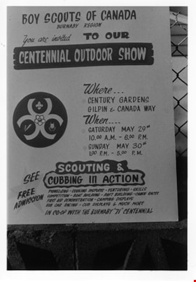
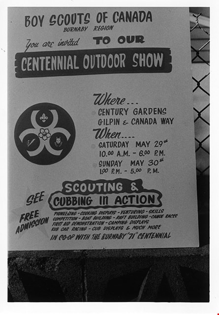
Boy Scouts Centennial Outdoor Show poster
https://search.heritageburnaby.ca/link/museumdescription2186
- Repository
- Burnaby Village Museum
- Date
- May 1971
- Collection/Fonds
- Donald Copan collection
- Description Level
- Item
- Physical Description
- 1 photograph : b&w ; 8.9 x 12.7 cm
- Scope and Content
- Photograph of poster for "Boy Scouts of Canada Burnaby Region Centennial Outdoor Show" at Century Gardens.
- Repository
- Burnaby Village Museum
- Collection/Fonds
- Donald Copan collection
- Series
- Copan album series
- Description Level
- Item
- Physical Description
- 1 photograph : b&w ; 8.9 x 12.7 cm
- Scope and Content
- Photograph of poster for "Boy Scouts of Canada Burnaby Region Centennial Outdoor Show" at Century Gardens.
- Subjects
- Organizations - Boys' Societies and Clubs
- Advertising Medium - Poster
- Celebrations - Centennials
- Names
- Boy Scouts of Canada
- Accession Code
- BV005.54.234
- Access Restriction
- No restrictions
- Reproduction Restriction
- May be restricted by third party rights
- Date
- May 1971
- Media Type
- Photograph
- Scan Resolution
- 600
- Scan Date
- July 21, 2020
- Scale
- 100
- Notes
- Title based on contents of photograph
Images

Burnaby Lake rowing course dredging
https://search.heritageburnaby.ca/link/archivedescription38303
- Repository
- City of Burnaby Archives
- Date
- 1971
- Collection/Fonds
- Burnaby Historical Society fonds
- Description Level
- Item
- Physical Description
- 1 photograph : col. ; 12.5 x 18 cm
- Scope and Content
- Aerial photograph of the Burnaby Lake rowing course being dredged in 1971, in preparation for the 1973 Canada Summer Games.
- Repository
- City of Burnaby Archives
- Date
- 1971
- Collection/Fonds
- Burnaby Historical Society fonds
- Subseries
- Photographs subseries
- Physical Description
- 1 photograph : col. ; 12.5 x 18 cm
- Description Level
- Item
- Record No.
- 400-001
- Access Restriction
- No restrictions
- Reproduction Restriction
- Reproduce for fair dealing purposes only
- Accession Number
- BHS2007-04
- Scope and Content
- Aerial photograph of the Burnaby Lake rowing course being dredged in 1971, in preparation for the 1973 Canada Summer Games.
- Media Type
- Photograph
- Notes
- Title based on contents of photograph
- Geographic Access
- Roberts Street
- Burnaby Lake
- Street Address
- 6871 Roberts Street
- Historic Neighbourhood
- Burnaby Lake (Historic Neighbourhood)
- Planning Study Area
- Burnaby Lake Area
Images


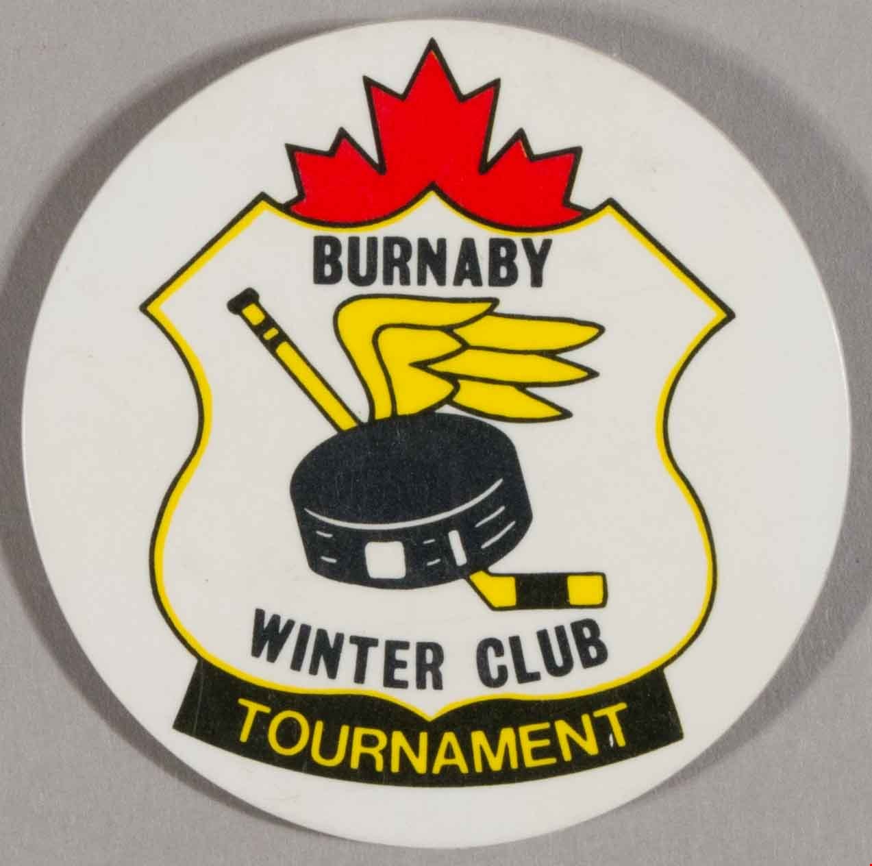
button pin
https://search.heritageburnaby.ca/link/museumartifact45853
- Repository
- Burnaby Village Museum
- Accession Code
- BV003.57.3
- Description
- The pin badge is a round, flat, plastic disc with pin fastener on back. The front is white with a black shield outline highlighted with yellow. Inside of this is black "BURNABY", then black hockey puck with yellow and black hockey stick behind it and yellow wings, then below, "WINTER CLUB". Below the shield, on a black bar, is a yellow "TOURNAMENT". Above the shield and partially covered by it is red maple leaf. The pin was issued by the Burnaby Winter Club. On the reverse in red is the manufacturers name.
- Category
- 08. Communication Artifacts
- Classification
- Documentary Artifacts - - Memorabilia
- Object Term
- Commemorative
- Marks/Labels
- "BURNABY / WINTER CLUB", text printed on the shield. "TOURNAMENT", text printed on the bar below th shield "THE GOLD LEAF IMPRINTERS / 2603 - 41ST STREET PHONE 542-7831 / VERNON, B.C. / POSTAL CODE V1T 6K3", there is a logo at left of 'G' and 'L' in red maple leaf. all of this is printed on the reverse face of the badge.
- Measurements
- Overall measurements diameter 4.6 cm.
- Maker
- Gold Leaf Imprinters
- Country Made
- Canada
- Province Made
- British Columbia
- Site/City Made
- Vernon
- Names
- Burnaby Winter Club
Images
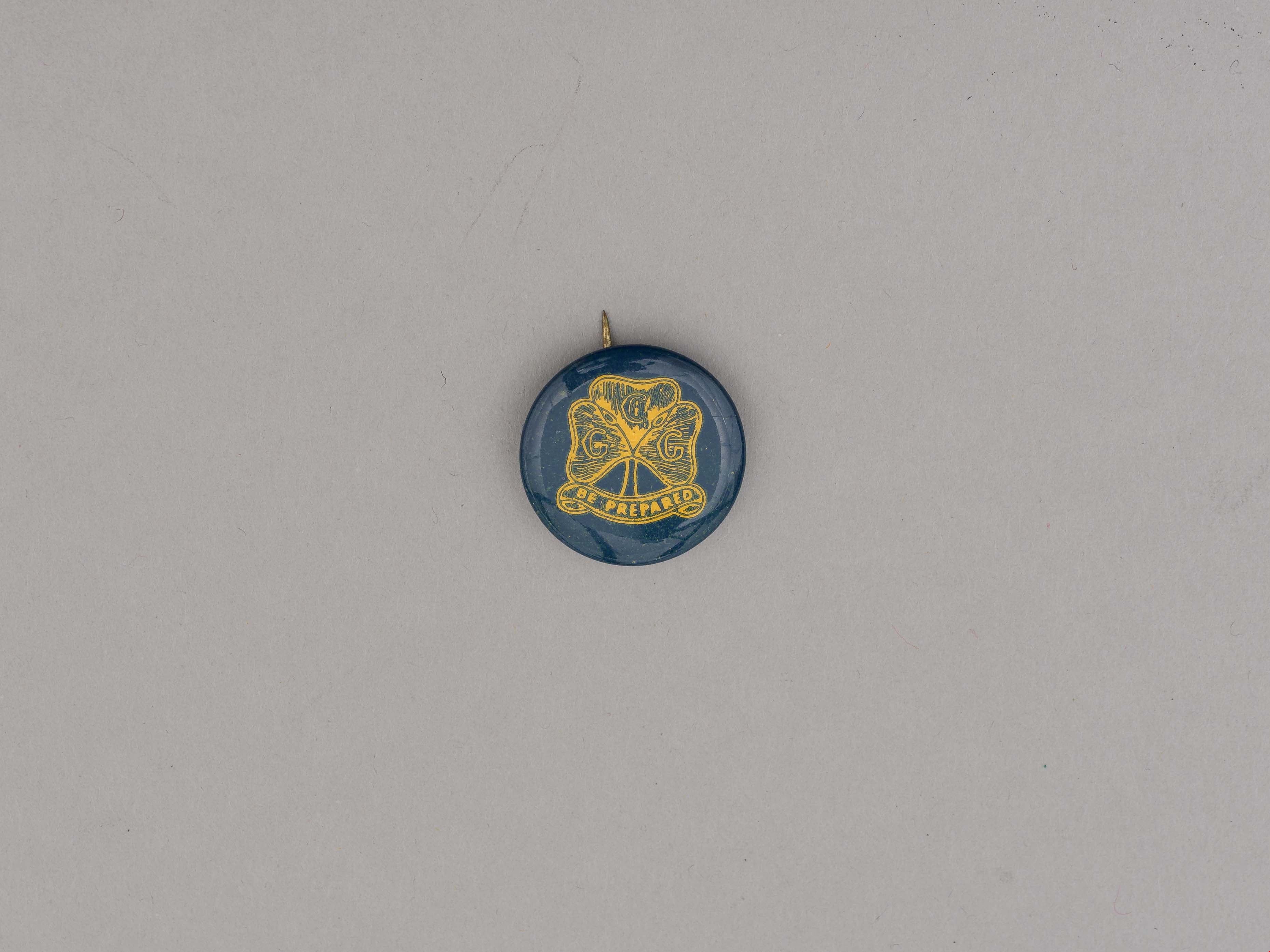
button pin
https://search.heritageburnaby.ca/link/museumartifact87602
- Repository
- Burnaby Village Museum
- Accession Code
- BV015.35.143
- Description
- button pin, Girl Guides; dark teal and yellow; Enrolment Pin; used in early 1940's when brass pins were unavailable; paper label on back reads: "MADE BY / Manitoba Stencil / and / Stamp Works / Winnipeg".
- Reference
- http://www.girlguides.ca/WEB/Documents/ON/Archives/Guide%20Badges%20A%20to%20G%20v3.pdf
- Category
- 03. Personal Artifacts
- Classification
- Adornment
- Personal Symbols
- Personal Symbols - - Personal Identification
- Personal Symbols - - Status Symbols
- Country Made
- Canada
- Province Made
- Manitoba
- Site/City Made
- Winnipeg
- Subjects
- Adornment
- Adornment - Lapel Pins
- Personal Symbols - Pins
- Organizations
- Organizations - Girls' Societies and Clubs
- Names
- Girl Guides of Canada
Images

Canada Way
https://search.heritageburnaby.ca/link/archivedescription79957
- Repository
- City of Burnaby Archives
- Date
- September, 1976
- Collection/Fonds
- Burnaby Public Library Contemporary Visual Archive Project
- Description Level
- Item
- Physical Description
- 1 photograph : b&w ; 11 x 16 cm mounted on cardboard
- Scope and Content
- Photograph shows a view looking west along Canada Way, taken from Westminster Avenue.
- Repository
- City of Burnaby Archives
- Date
- September, 1976
- Collection/Fonds
- Burnaby Public Library Contemporary Visual Archive Project
- Physical Description
- 1 photograph : b&w ; 11 x 16 cm mounted on cardboard
- Description Level
- Item
- Record No.
- 556-522
- Access Restriction
- No restrictions
- Reproduction Restriction
- Reproduce for fair dealing purposes only
- Accession Number
- 2013-13
- Scope and Content
- Photograph shows a view looking west along Canada Way, taken from Westminster Avenue.
- Subjects
- Aerial Photographs
- Media Type
- Photograph
- Photographer
- Campbell, Peg
- Notes
- Scope note taken directly from BPL photograph description.
- 1 b&w copy negative : 10 x 12.5 cm accompanying
- Geographic Access
- Canada Way
- Westminster Avenue
- Planning Study Area
- Douglas-Gilpin Area
Images

![The Fair Haven, [between 1950 and 1957] thumbnail](/media/Hpo/_Data/_Archives_Images/_Unrestricted/251/305-001.jpg?width=280)
The Fair Haven
https://search.heritageburnaby.ca/link/archivedescription36597
- Repository
- City of Burnaby Archives
- Date
- [between 1950 and 1957]
- Collection/Fonds
- Burnaby Historical Society fonds
- Description Level
- Item
- Physical Description
- 1 photograph : col. postcard ; 9 x 14 cm
- Scope and Content
- Aerial photographic postcard of "the Fair Haven," a group of United Church homes for Senior Citizens. The road in the foreground is Rumble Street, and the long road to the right is Sussex Avenue. The small forest behind "the Fair Haven" is the David Gary Park.
- Repository
- City of Burnaby Archives
- Date
- [between 1950 and 1957]
- Collection/Fonds
- Burnaby Historical Society fonds
- Subseries
- Vera Jackson Pel subseries
- Physical Description
- 1 photograph : col. postcard ; 9 x 14 cm
- Description Level
- Item
- Record No.
- 305-001
- Access Restriction
- No restrictions
- Reproduction Restriction
- Reproduce for fair dealing purposes only
- Accession Number
- BHS1992-46
- Scope and Content
- Aerial photographic postcard of "the Fair Haven," a group of United Church homes for Senior Citizens. The road in the foreground is Rumble Street, and the long road to the right is Sussex Avenue. The small forest behind "the Fair Haven" is the David Gary Park.
- Subjects
- Aerial Photographs
- Documentary Artifacts - Postcards
- Buildings - Residential - Seniors Housing
- Names
- Fair Haven
- Media Type
- Photograph
- Notes
- Typewritten note on verso of postcard reads: "AERIAL VIEW/ 'The Fairhaven', Burnaby BC / United Church Homes for Senior Citizens / 4341 Rumble St., Burnaby, BC"
- Handwritten note on verso of postcard reads: ""The road in the foreground is Rumble Street. The long road to the right is Sussex Avenue. The road, going up, on the left, barely visible is McKay Avenue = lower corner. Behind Fair Haven is the future David Gary Park cleared in the late 1950's - then more trees were felled in October 1962 with Hurricane Freda (blown over, uprooted trees) that left the park as it is today in 1993. The top row of little (5) white cottages were moved from the N.W. corner of Willingdon and Kingsway where Old Orchard Mall is now - they were part of Old Orchard Auto Villas, the first Fair Havens. Note: All cottages on right side of Lodge have been moved to Vancouver Island in 1991 for Motel units - by barge."
- Printed on verso of postcard: "Traveltime product, made in Vancouver, Canada, by Grant-Mann Lithographers Ltd."
- Geographic Access
- Rumble Street
- Street Address
- 4341 Rumble Street
- Historic Neighbourhood
- Alta-Vista (Historic Neighbourhood)
- Planning Study Area
- Sussex-Nelson Area
Images
![The Fair Haven, [between 1950 and 1957] thumbnail](/media/Hpo/_Data/_Archives_Images/_Unrestricted/251/305-001.jpg)

Highway No. 1
https://search.heritageburnaby.ca/link/archivedescription79950
- Repository
- City of Burnaby Archives
- Date
- September, 1976
- Collection/Fonds
- Burnaby Public Library Contemporary Visual Archive Project
- Description Level
- Item
- Physical Description
- 1 photograph : b&w ; 11 x 16 cm mounted on cardboard
- Scope and Content
- Photograph shows a view of the No. 1 Highway looking northwest from Sprott Street overpass.
- Repository
- City of Burnaby Archives
- Date
- September, 1976
- Collection/Fonds
- Burnaby Public Library Contemporary Visual Archive Project
- Physical Description
- 1 photograph : b&w ; 11 x 16 cm mounted on cardboard
- Description Level
- Item
- Record No.
- 556-520
- Access Restriction
- No restrictions
- Reproduction Restriction
- Reproduce for fair dealing purposes only
- Accession Number
- 2013-13
- Scope and Content
- Photograph shows a view of the No. 1 Highway looking northwest from Sprott Street overpass.
- Subjects
- Aerial Photographs
- Media Type
- Photograph
- Photographer
- Salmon, Stu
- Notes
- Scope note taken directly from BPL photograph description.
- 1 b&w copy negative : 10 x 12.5 cm accompanying
- Geographic Access
- Trans Canada Highway
- Historic Neighbourhood
- Burnaby Lake (Historic Neighbourhood)
- Planning Study Area
- Douglas-Gilpin Area
Images


Highway No. 1
https://search.heritageburnaby.ca/link/archivedescription79977
- Repository
- City of Burnaby Archives
- Date
- September 23, 1976
- Collection/Fonds
- Burnaby Public Library Contemporary Visual Archive Project
- Description Level
- Item
- Physical Description
- 1 photograph : b&w ; 11 x 16 cm mounted on cardboard
- Scope and Content
- Photograph shows a view of underdeveloped area and the No. 1 Highway looking northwest from the Sperling Overpass with Capitol Hill in the background.
- Repository
- City of Burnaby Archives
- Date
- September 23, 1976
- Collection/Fonds
- Burnaby Public Library Contemporary Visual Archive Project
- Physical Description
- 1 photograph : b&w ; 11 x 16 cm mounted on cardboard
- Description Level
- Item
- Record No.
- 556-533
- Access Restriction
- No restrictions
- Reproduction Restriction
- Reproduce for fair dealing purposes only
- Accession Number
- 2013-13
- Scope and Content
- Photograph shows a view of underdeveloped area and the No. 1 Highway looking northwest from the Sperling Overpass with Capitol Hill in the background.
- Subjects
- Aerial Photographs
- Media Type
- Photograph
- Photographer
- Campbell, Peg
- Notes
- Scope note taken directly from BPL photograph description.
- 1 b&w copy negative : 10 x 12.5 cm accompanying
- Geographic Access
- Trans Canada Highway
- Planning Study Area
- Ardingley-Sprott Area
Images

lapel pin
https://search.heritageburnaby.ca/link/museumartifact6645
- Repository
- Burnaby Village Museum
- Accession Code
- BV985.97.3
- Description
- Pin, round, enamelled brass. Wide blue border around outside with thin gold edges and gold lettering "INTERNATIONAL. BOWLING. TEAM. / VISIT. 1927. TO. CANADA". Inner part of pin is cruciform, with round centre connected to outer edge with four arms, open cut-out areas between. Each arm shows a coloured enamel floral symbol. At top is the rose, at right are shamrocks, at bottom is the lily, at left is the thistle. At the centre of the pin is the Royal Coat of Arms of the United Kingdom in red and blue with gold. Locking pin back on reverse, open loop. "R. SCOTT / GLASGOW" in raised letters near bottom edge. Some discolouration on back, very slight wear on front.
- Category
- 08. Communication Artifacts
- Classification
- Documentary Artifacts - - Memorabilia
- Object Term
- Commemorative
- Marks/Labels
- "INTERNATIONAL BOWLING TEAM", embossed gold lettering in half circle along top of pin "VISIT 1927 TO CANADA", embossed gold lettering in half circle along bottom of pin
- Measurements
- Dia: 2.9 cm
- Country Made
- Scotland
- Site/City Made
- Glasgow
- Subjects
- Adornment
- Adornment - Lapel Pins
- Advertising Medium
- Events - Competitions
- Organizations - Athletic Associations
- Sports - Bowling
Images


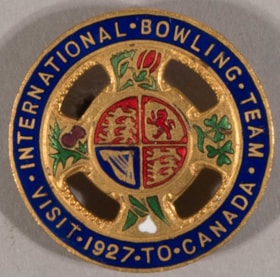
lapel pin
https://search.heritageburnaby.ca/link/museumartifact47178
- Repository
- Burnaby Village Museum
- Accession Code
- BV004.43.22
- Description
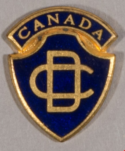
- Pin, blue and gold; "Canada"; "CD" monogram [Civil Defense]
- Category
- 08. Communication Artifacts
- Classification
- Personal Symbols
- Object Term
- Insignia
- Marks/Labels
- Canada / CD
Images

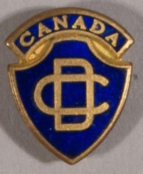
lapel pin
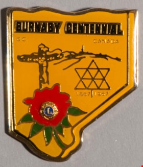
https://search.heritageburnaby.ca/link/museumartifact47223
- Repository
- Burnaby Village Museum
- Accession Code
- BV004.50.29
- Description
- Pin; yellow, red, green, gold; "Burnaby Centennial" "BC" "Canada"; totem pole, maple leaf, "1867 - 1967", rhododendron, 'L' [Lion's Club]
- Category
- 08. Communication Artifacts
- Classification
- Documentary Artifacts - - Memorabilia
- Object Term
- Commemorative
- Marks/Labels
- Burnaby Centennial / BC / Canada / 1867 - 1967 / L
Images


lapel pin
https://search.heritageburnaby.ca/link/museumartifact47230
- Repository
- Burnaby Village Museum
- Accession Code
- BV004.50.36
- Description
- Pin; blue and gold; "Canada"; monogram 'CD' [Civil Defense]; screw back missing
- Category
- 08. Communication Artifacts
- Classification
- Personal Symbols
- Object Term
- Insignia
- Marks/Labels
- Canada / CD
- Subjects
- Adornment
- Adornment - Lapel Pins
- Personal Symbols - Pins
- Organizations
- Emergency Measures - Civil Defence
Images
lapel pin
https://search.heritageburnaby.ca/link/museumartifact47239
- Repository
- Burnaby Village Museum
- Accession Code
- BV004.50.45
- Description
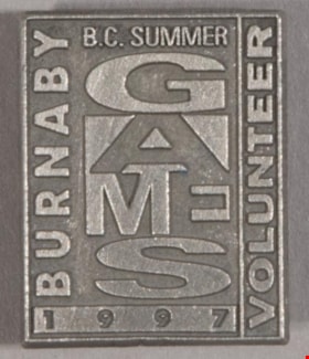
- Pin, vertical rectangle, grey metal with raised lettering and borders. At top, "B.C. SUMMER", then vertically arranged "GAMES" in wide letters in alternately positive and negative print, then "1997" at bottom in raised bar. "BURNABY" up left side, "VOLUNTEER" up right side, both perpendicular to other print. Back of pin is textured grey metal with post and butterfly clutch fastener. Post is set in round base with stop. Near edge of pin is "R" in circle, "ARTISS / REGINA / CANADA". Clutch is shiny silver metal with stamped "BALLOU REG'D / 130 YEARS".
- Object History
- The B.C. Games were established in 1977, and the first summer games were held in 1978. Commemorative pin for the 1997 B.C. Summer Games held in Burnaby [for volunteers].
- Category
- 08. Communication Artifacts
- Classification
- Documentary Artifacts - - Memorabilia
- Object Term
- Commemorative
- Marks/Labels
- Burnaby / B.C. Summer Games / Volunteer / 1997
- Colour
- Silver
- Measurements
- L: 2.2 cm x W: 1.8 cm
- Subjects
- Adornment
- Adornment - Lapel Pins
- Events - Competitions
- Personal Symbols - Pins
- Sports
- Persons - Volunteers
Images
lapel pin
https://search.heritageburnaby.ca/link/museumartifact47240
- Repository
- Burnaby Village Museum
- Accession Code
- BV004.50.46
- Description
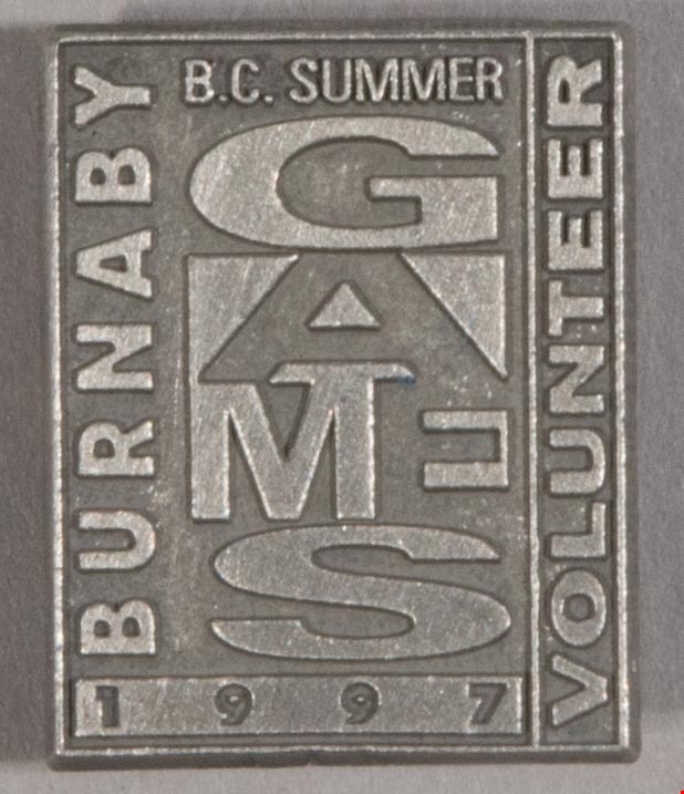
- Pin, vertical rectangle, grey metal with raised lettering and borders. At top, "B.C. SUMMER", then vertically arranged "GAMES" in wide letters in alternately positive and negative print, then "1997" at bottom in raised bar. "BURNABY" up left side, "VOLUNTEER" up right side, both perpendicular to other print. Back of pin is textured grey metal with post and butterfly clutch fastener. Post is set in round base with stop. Near edge of pin is "R" in circle, "ARTISS / REGINA / CANADA". Clutch is shiny silver metal with stamped "BALLOU REG'D / 130 YEARS".
- Object History
- The B.C. Games were established in 1977, and the first summer games were held in 1978. Commemorative pin for the 1997 B.C. Summer Games held in Burnaby [for volunteers].
- Category
- 08. Communication Artifacts
- Classification
- Documentary Artifacts - - Memorabilia
- Object Term
- Commemorative
- Marks/Labels
- Burnaby / B.C. Summer Games / Volunteer / 1997
- Colour
- Silver
- Measurements
- L: 2L: 2.2 cm x W: 1.8 cm
- Subjects
- Adornment
- Adornment - Lapel Pins
- Events - Competitions
- Personal Symbols - Pins
- Sports
- Persons - Volunteers
Images