Narrow Results By
Subject
- Academic Disciplines 3
- Accidents 1
- Accidents - Automobile Accidents 4
- Adornment 22
- Adornment - Lapel Pins 24
- Advertising Medium 43
- Advertising Medium - Business Cards 8
- Advertising Medium - Flyer
- Advertising Medium - Poster 1
- Advertising Medium - Signs and Signboards 29
- Aerial Photographs
- Agricultural Tools and Equipment 5
Person / Organization
- Burnaby Centennial '71 Committee 1
- Burnaby Historical Society 1
- Burnaby Rhododendron and Spring Flower Show Society 1
- Burnaby Village Museum 12
- Canada Summer Games 5
- Canada Way Food Market 1
- Century Park Museum Association 5
- Fair Haven 1
- Lenkurt Electric Company 1
- Sidney Roofing and Paper Company Limited 1
- Toy, Harry Wee Koon "Harry" 1

advertising flyer
https://search.heritageburnaby.ca/link/museumartifact1787
- Repository
- Burnaby Village Museum
- Accession Code
- HV971.105.1
- Description
- Meat Specials! - Advertising flyer. Produced for Mayflower Meat Market, Douglas Road and Edmonds Street, Phone 152
- Object History
- Donor owned the Mayflower Meat Market.
- Maker
- Royal Press
- Country Made
- Canada
- Province Made
- British Columbia
- Site/City Made
- New Westminster
- Geographic Access
- Douglas Road
- Edmonds Street
- Historic Neighbourhood
- Edmonds (Historic Neighbourhood)
Images


advertising flyer
https://search.heritageburnaby.ca/link/museumartifact1788
- Repository
- Burnaby Village Museum
- Accession Code
- HV971.105.2
- Description
- Depednable Quality Plus Real Economy - Advertising flyer. Produced for for Mayflower Meat Market, Edmonds Street at Douglas Road; Phone 152
- Object History
- Donor owned the Mayflower Meat Market on Grandview-Douglas Highway.
- Country Made
- Canada
- Geographic Access
- Douglas Road
- Edmonds Street
- Historic Neighbourhood
- Edmonds (Historic Neighbourhood)
Images

Aerial photograph of Burnaby
https://search.heritageburnaby.ca/link/archivedescription84903
- Repository
- City of Burnaby Archives
- Date
- 1963
- Collection/Fonds
- Allan Amundsen collection
- Description Level
- Item
- Physical Description
- 1 photograph : b&w ; 22.5 x 22.5 cm
- Scope and Content
- Aerial photograph of Burnaby with the Trans Canada Highway running through and the Forest Lawn Cemetery to the south.
- Repository
- City of Burnaby Archives
- Date
- 1963
- Collection/Fonds
- Allan Amundsen collection
- Physical Description
- 1 photograph : b&w ; 22.5 x 22.5 cm
- Description Level
- Item
- Record No.
- 561-024
- Access Restriction
- In Archives only
- Reproduction Restriction
- No reproduction permitted
- Accession Number
- 2014-08
- Scope and Content
- Aerial photograph of Burnaby with the Trans Canada Highway running through and the Forest Lawn Cemetery to the south.
- Subjects
- Aerial Photographs
- Media Type
- Photograph
- Photographer
- Province of British Columbia
- Notes
- Title based on contents of photograph
- This photo is indentified as BC5062:27 and connects with B.C. air photograph BC5061:26 to the east
- Historic Neighbourhood
- Burnaby Lake (Historic Neighbourhood)
- Planning Study Area
- Douglas-Gilpin Area
- Ardingley-Sprott Area
- Dawson-Delta Area
Aerial photograph of Burnaby
https://search.heritageburnaby.ca/link/archivedescription84907
- Repository
- City of Burnaby Archives
- Date
- 1963
- Collection/Fonds
- Allan Amundsen collection
- Description Level
- Item
- Physical Description
- 1 photograph : b&w ; 22.5 x 22.5 cm
- Scope and Content
- Aerial photograph of Burnaby with the Trans Canada Highway running from through and Burnaby Lake in the south east corner.
- Repository
- City of Burnaby Archives
- Date
- 1963
- Collection/Fonds
- Allan Amundsen collection
- Physical Description
- 1 photograph : b&w ; 22.5 x 22.5 cm
- Description Level
- Item
- Record No.
- 561-025
- Access Restriction
- In Archives only
- Reproduction Restriction
- No reproduction permitted
- Accession Number
- 2014-08
- Scope and Content
- Aerial photograph of Burnaby with the Trans Canada Highway running from through and Burnaby Lake in the south east corner.
- Subjects
- Aerial Photographs
- Media Type
- Photograph
- Photographer
- Province of British Columbia
- Notes
- Title based on contents of photograph
- This photo is indentified as BC5062:26 and connects with B.C. air photograph BC5062:27 to the west and B.C. air photograph BC5062:25 to the east
- Historic Neighbourhood
- Burnaby Lake (Historic Neighbourhood)
- Planning Study Area
- Douglas-Gilpin Area
- Ardingley-Sprott Area
- Burnaby Lake Area
Aerial photograph of Burnaby
https://search.heritageburnaby.ca/link/archivedescription84911
- Repository
- City of Burnaby Archives
- Date
- 1963
- Collection/Fonds
- Allan Amundsen collection
- Description Level
- Item
- Physical Description
- 1 photograph : b&w ; 22.5 x 22.5 cm
- Scope and Content
- Aerial photograph of Burnaby with Lougheed Highway running west to east through the middle of the photograph and the Trans Canada Highway in the lower left segment.
- Repository
- City of Burnaby Archives
- Date
- 1963
- Collection/Fonds
- Allan Amundsen collection
- Physical Description
- 1 photograph : b&w ; 22.5 x 22.5 cm
- Description Level
- Item
- Record No.
- 561-029
- Access Restriction
- In Archives only
- Reproduction Restriction
- No reproduction permitted
- Accession Number
- 2014-08
- Scope and Content
- Aerial photograph of Burnaby with Lougheed Highway running west to east through the middle of the photograph and the Trans Canada Highway in the lower left segment.
- Subjects
- Aerial Photographs
- Media Type
- Photograph
- Photographer
- Province of British Columbia
- Notes
- Title based on contents of photograph
- This photo is indentified as BC5062:22 and connects with B.C. air photograph BC5062:23 to the west and B.C. air photograph BC5062:21
- Historic Neighbourhood
- Lozells (Historic Neighbourhood)
- Burquitlam (Historic Neighbourhood)
- Planning Study Area
- Lake City Area
- Government Road Area
- Burnaby Lake Area
- Lyndhurst Area
- Cariboo-Armstrong Area
Aerial photograph of Burnaby
https://search.heritageburnaby.ca/link/archivedescription84913
- Repository
- City of Burnaby Archives
- Date
- 1963
- Collection/Fonds
- Allan Amundsen collection
- Description Level
- Item
- Physical Description
- 1 photograph : b&w ; 22.5 x 22.5 cm
- Scope and Content
- Aerial photograph of East Burnaby up to North Road and south of the Trans Canada Highway.
- Repository
- City of Burnaby Archives
- Date
- 1963
- Collection/Fonds
- Allan Amundsen collection
- Physical Description
- 1 photograph : b&w ; 22.5 x 22.5 cm
- Description Level
- Item
- Record No.
- 561-031
- Access Restriction
- In Archives only
- Reproduction Restriction
- No reproduction permitted
- Accession Number
- 2014-08
- Scope and Content
- Aerial photograph of East Burnaby up to North Road and south of the Trans Canada Highway.
- Subjects
- Aerial Photographs
- Media Type
- Photograph
- Photographer
- Province of British Columbia
- Notes
- Title based on contents of photograph
- This photo is indentified as BC5062:70 and connects with B.C. air photograph BC5062:21 to the west and BC5062:71 to the east
- Historic Neighbourhood
- East Burnaby (Historic Neighbourhood)
- Planning Study Area
- Cameron Area
- Cariboo-Armstrong Area
Aerial photograph of Burnaby Lake Area
https://search.heritageburnaby.ca/link/archivedescription84908
- Repository
- City of Burnaby Archives
- Date
- 1963
- Collection/Fonds
- Allan Amundsen collection
- Description Level
- Item
- Physical Description
- 1 photograph : b&w ; 22.5 x 22.5 cm
- Scope and Content
- Aerial photograph of Burnaby with Lougheed Highway in the north west corner, the Trans Canada Highway in the south east corner and Burnaby Lake appearing from the west.
- Repository
- City of Burnaby Archives
- Date
- 1963
- Collection/Fonds
- Allan Amundsen collection
- Physical Description
- 1 photograph : b&w ; 22.5 x 22.5 cm
- Description Level
- Item
- Record No.
- 561-026
- Access Restriction
- In Archives only
- Reproduction Restriction
- No reproduction permitted
- Accession Number
- 2014-08
- Scope and Content
- Aerial photograph of Burnaby with Lougheed Highway in the north west corner, the Trans Canada Highway in the south east corner and Burnaby Lake appearing from the west.
- Subjects
- Aerial Photographs
- Media Type
- Photograph
- Photographer
- Province of British Columbia
- Notes
- Title based on contents of photograph
- This photo is indentified as BC5062:25 and connects with B.C. air photograph BC5062:26 to the west and B.C. air photograph BC5062:24 to the east
- Historic Neighbourhood
- Burnaby Lake (Historic Neighbourhood)
- Lozells (Historic Neighbourhood)
- Planning Study Area
- Douglas-Gilpin Area
- Sperling-Broadway Area
- Government Road Area
- Burnaby Lake Area
![Aerial photograph of the Burnaby Village area, [1946] (date of original), copied 1991 thumbnail](/media/hpo/_Data/_Archives_Images/_Unrestricted/370/370-532.jpg?width=280)
Aerial photograph of the Burnaby Village area
https://search.heritageburnaby.ca/link/archivedescription37945
- Repository
- City of Burnaby Archives
- Date
- [1946] (date of original), copied 1991
- Collection/Fonds
- Burnaby Historical Society fonds
- Description Level
- Item
- Physical Description
- 1 photograph : b&w ; 3.5 x 4.4 cm print on contact sheet 20.5 x 26.7 cm
- Scope and Content
- Aerial photograph of the Sperling Avenue/Douglas Road Burnaby Village area.
- Repository
- City of Burnaby Archives
- Date
- [1946] (date of original), copied 1991
- Collection/Fonds
- Burnaby Historical Society fonds
- Subseries
- Burnaby Image Bank subseries
- Physical Description
- 1 photograph : b&w ; 3.5 x 4.4 cm print on contact sheet 20.5 x 26.7 cm
- Description Level
- Item
- Record No.
- 370-532
- Access Restriction
- No restrictions
- Reproduction Restriction
- No known restrictions
- Accession Number
- BHS1999-03
- Scope and Content
- Aerial photograph of the Sperling Avenue/Douglas Road Burnaby Village area.
- Subjects
- Aerial Photographs
- Media Type
- Photograph
- Notes
- Title based on contents of photograph
- 1 b&w copy negative accompanying
- Negative has a pink cast
- Geographic Access
- Douglas Road
- Sperling Avenue
- Canada Way
- Historic Neighbourhood
- Burnaby Lake (Historic Neighbourhood)
Images
![Aerial photograph of the Burnaby Village area, [1946] (date of original), copied 1991 thumbnail](/media/hpo/_Data/_Archives_Images/_Unrestricted/370/370-532.jpg)
brochure
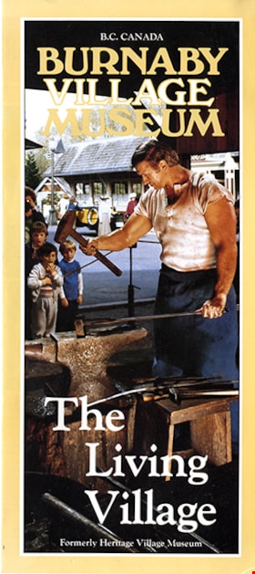
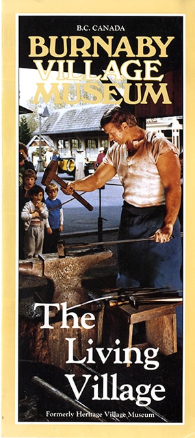
https://search.heritageburnaby.ca/link/museumartifact90268
- Repository
- Burnaby Village Museum
- Accession Code
- BV020.4.19
- Description
- Burnaby Village Museum brochure; single fold; glossy paper; text in yellow and white on front reads: "B.C. Canada / BURNABY / VILLAGE / MUSEUM / The Living Village / Formerly Heritage Village Museum"; front features a colour photograph of a Village blacksmith at work at an anvil; text and colour photographs inside describe some of the attractions to be found at the Burnaby Village Museum; back lists featured annual celebrations and has a location map.
- Object History
- Part of Burnaby Village Museum Marketing Office on site at Burnaby Village Museum.
- Category
- 08. Communication Artifacts
- Classification
- Advertising Media
- Object Term
- Brochure
- Measurements
- 22.5 cm x 20 cm folded to 22.5 cm x 10 cm
- Publication Date
- [198-]
- Subjects
- Advertising Medium - Flyer
- Names
- Burnaby Village Museum
Images

brochure
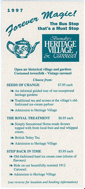
https://search.heritageburnaby.ca/link/museumartifact91085
- Repository
- Burnaby Village Museum
- Accession Code
- BV020.5.1809
- Description
- Burnaby Village Museum brochure; teal coloured ink on grey speckled card stock; text at top reads: "1997 / Forever Magic / The Bus Stop / that's a Must Stop"; illustration of tea pot to the left of teal retangular block with light coloured text: "Burnaby's / HERITAGE / VILLAGE / & Carousel"; Other information on Brochure from top to bottom in bold reads: "Open air historical village and gardens / Costumed townsfolk. Vintage carousel / SEEDS OF CHANGE / THE ROYAL TREATMENT / STEP BACK IN TIME / (see reverse for location and booking information). Verso of card in teal coloured ink. text in bold top to bottom reads: "HOW TO GET THERE / By Car.../ By Bus.../ By Skytrain / illustration of a a couple driving a vintage automobile / BOOKING INFORMATIION / We look forward to hosting your group! / Burnaby Village Museum..."
- Object History
- Item was found in Burnaby Village Museum printshop along with other Heritage Village / Burnaby Village Museum ephemera created between 1971 and [2000].
- Category
- 08. Communication Artifacts
- Classification
- Advertising Media
- Object Term
- Brochure
- Measurements
- 23 x 10 cm
- Country Made
- Canada
- Province Made
- British Columbia
- Site/City Made
- Burnaby
- Author
- Burnaby Village Museum
- Publication Date
- 1997
- Subjects
- Advertising Medium - Flyer
Images
brochure
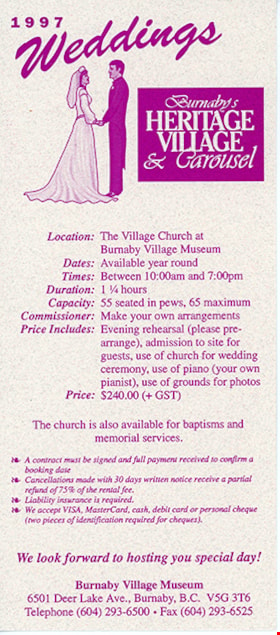
https://search.heritageburnaby.ca/link/museumartifact91086
- Repository
- Burnaby Village Museum
- Accession Code
- BV020.5.1808
- Description
- Burnaby Village Museum brochure; purple ink on grey speckled card stock; text at top reads: "1997 / Weddings"; illustration of bride and groom to the left of purple retangular block with light coloured text: "Burnaby's / HERITAGE / VILLAGE / & Carousel"; Other information on Brochure from top to bottom in bold reads: "Location / Dates: / Times: / Duration / Capacity / Commissioner / Price Includes: / Price / We look forward to hosting your special day! / Burnaby Village Museum ..." Verso of card, with text in purple reads: "Wedding Photos" / illustration of a camera to the left of purple retangular block with light coloured text: "Burnaby's / HERITAGE / VILLAGE / & Carousel"; Other information on Brochure from top to bottom in bold reads: Photo Sessions / WEDDINGS ON SITE / Site photos / Carousel Photos / WEDDINGS OFF SITE / Site Photos / Carousel Photos / Burnaby Village Museum ..."
- Object History
- Item was found in Burnaby Village Museum printshop along with other Heritage Village / Burnaby Village Museum ephemera created between 1971 and [2000].
- Category
- 08. Communication Artifacts
- Classification
- Advertising Media
- Object Term
- Brochure
- Colour
- Purple
- Gray
- Measurements
- 23 x 10 cm
- Country Made
- Canada
- Province Made
- British Columbia
- Site/City Made
- Burnaby
- Author
- Burnaby Village Museum
- Publication Date
- 1997
- Subjects
- Advertising Medium - Flyer
- Names
- Burnaby Village Museum
Images

brochure
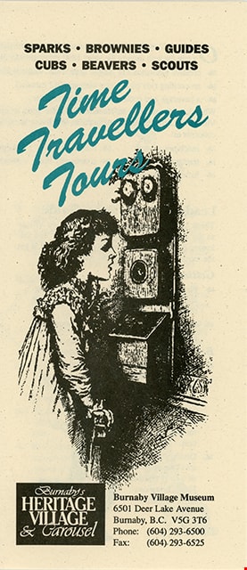
https://search.heritageburnaby.ca/link/museumartifact91087
- Repository
- Burnaby Village Museum
- Accession Code
- BV020.5.1811
- Description
- Burnaby Village Museum brochure; bifolded; front cover in black ink with title in teal coloured ink title "Time / Travellers / Tours"; illustration of young girl standing at an old box telephone; text at top in black reads: "SPARKS. / BROWNIES . / GUIDES . / CUBS . / BEAVERS . / SCOUTS. "; rectangular text box at bottom in black reads " Burnaby's / HERITAGE / VILLAGE / & Carousel"; information on inside of Brochure with text in bold reads: "Leader's Preparation Guide / Getting Organized / Before Arriving / When you Arrive"; includes illustration of a boy flying a kite and a dog watching. Verso of Brochure with text in bold reads: "Available Dates / DAYTIME / EVENINGS / Fees / Payment Information / How to Get There"; Map showing location of Burnaby Village Museum.
- Object History
- Item was found in Burnaby Village Museum printshop along with other Heritage Village / Burnaby Village Museum ephemera created between 1971 and [2000].
- Category
- 08. Communication Artifacts
- Classification
- Advertising Media
- Object Term
- Brochure
- Colour
- Black
- Green
- Gray
- Measurements
- 23 x 10 cm
- Country Made
- Canada
- Province Made
- British Columbia
- Site/City Made
- Burnaby
- Author
- Burnaby Village Museum
- Publication Date
- [1997]
- Subjects
- Advertising Medium - Flyer
Images

brochure
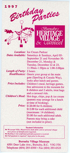
https://search.heritageburnaby.ca/link/museumartifact91088
- Repository
- Burnaby Village Museum
- Accession Code
- BV020.5.1810
- Description
- Burnaby Village Museum brochure; magenta coloured ink on grey speckled card stock; text at top reads: "1997 / Birthday Parties"; illustration of carousel horse to the left of magenta retangular block with light coloured text: "Burnaby's / HERITAGE / VILLAGE / & Carousel"; Other information on Brochure from top to bottom in bold reads: "Location: / Dates Available: / Length of Party: / Host/Hostess: / Price Includes: / Children's Meal: / Price: / Payment Information / Burnaby Village Museum..."
- Object History
- Item was found in Burnaby Village Museum printshop along with other Heritage Village / Burnaby Village Museum ephemera created between 1971 and [2000].
- Category
- 08. Communication Artifacts
- Classification
- Advertising Media
- Object Term
- Brochure
- Colour
- Pink
- Gray
- Measurements
- 23 x 10 cm
- Country Made
- Canada
- Province Made
- British Columbia
- Site/City Made
- Burnaby
- Author
- Burnaby Village Museum
- Publication Date
- 1997
- Subjects
- Advertising Medium - Flyer
Images
brochure
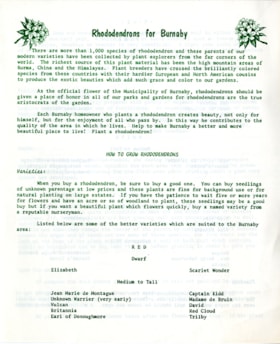
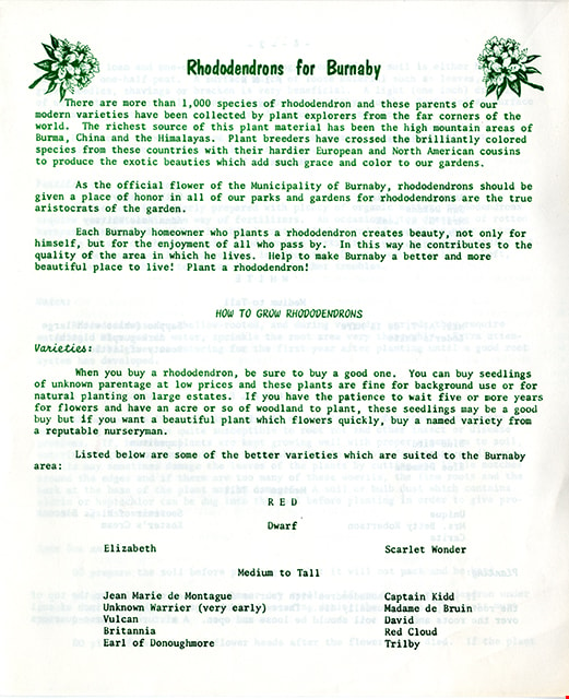
https://search.heritageburnaby.ca/link/museumartifact91363
- Repository
- Burnaby Village Museum
- Accession Code
- BV020.5.2110
- Description
- Rhodendrons for Burnaby brochure; folded at centre; printed on both sides in green ink. Title on front reads: "Rhododendrons for Burnaby". Brochure includes information about rhododendron varities and information on how to grow them from W.D. Christie, Horticulturist Greenhouse and Nursery Crops and lists members of the Centennial Beautification Committee and Chairman of the Rhododendron and Spring Flower Show; April 1967.
- Object History
- Item was created for the Rhododenron and Spring Flower Show, April 1967.
- Category
- 08. Communication Artifacts
- Classification
- Advertising Media
- Object Term
- Brochure
- Colour
- White
- Black
- Measurements
- Length: 35.5 cm x Width: 21.5 cm folded to Length: 17.5 x 21.5 cm
- Country Made
- Canada
- Province Made
- British Columbia
- Site/City Made
- Burnaby
- Publication Date
- April 1967
- Subjects
- Advertising Medium - Flyer
Images

Burnaby Lake rowing course dredging
https://search.heritageburnaby.ca/link/archivedescription38303
- Repository
- City of Burnaby Archives
- Date
- 1971
- Collection/Fonds
- Burnaby Historical Society fonds
- Description Level
- Item
- Physical Description
- 1 photograph : col. ; 12.5 x 18 cm
- Scope and Content
- Aerial photograph of the Burnaby Lake rowing course being dredged in 1971, in preparation for the 1973 Canada Summer Games.
- Repository
- City of Burnaby Archives
- Date
- 1971
- Collection/Fonds
- Burnaby Historical Society fonds
- Subseries
- Photographs subseries
- Physical Description
- 1 photograph : col. ; 12.5 x 18 cm
- Description Level
- Item
- Record No.
- 400-001
- Access Restriction
- No restrictions
- Reproduction Restriction
- Reproduce for fair dealing purposes only
- Accession Number
- BHS2007-04
- Scope and Content
- Aerial photograph of the Burnaby Lake rowing course being dredged in 1971, in preparation for the 1973 Canada Summer Games.
- Media Type
- Photograph
- Notes
- Title based on contents of photograph
- Geographic Access
- Roberts Street
- Burnaby Lake
- Street Address
- 6871 Roberts Street
- Historic Neighbourhood
- Burnaby Lake (Historic Neighbourhood)
- Planning Study Area
- Burnaby Lake Area
Images


Canada Way
https://search.heritageburnaby.ca/link/archivedescription79957
- Repository
- City of Burnaby Archives
- Date
- September, 1976
- Collection/Fonds
- Burnaby Public Library Contemporary Visual Archive Project
- Description Level
- Item
- Physical Description
- 1 photograph : b&w ; 11 x 16 cm mounted on cardboard
- Scope and Content
- Photograph shows a view looking west along Canada Way, taken from Westminster Avenue.
- Repository
- City of Burnaby Archives
- Date
- September, 1976
- Collection/Fonds
- Burnaby Public Library Contemporary Visual Archive Project
- Physical Description
- 1 photograph : b&w ; 11 x 16 cm mounted on cardboard
- Description Level
- Item
- Record No.
- 556-522
- Access Restriction
- No restrictions
- Reproduction Restriction
- Reproduce for fair dealing purposes only
- Accession Number
- 2013-13
- Scope and Content
- Photograph shows a view looking west along Canada Way, taken from Westminster Avenue.
- Subjects
- Aerial Photographs
- Media Type
- Photograph
- Photographer
- Campbell, Peg
- Notes
- Scope note taken directly from BPL photograph description.
- 1 b&w copy negative : 10 x 12.5 cm accompanying
- Geographic Access
- Canada Way
- Westminster Avenue
- Planning Study Area
- Douglas-Gilpin Area
Images

![The Fair Haven, [between 1950 and 1957] thumbnail](/media/Hpo/_Data/_Archives_Images/_Unrestricted/251/305-001.jpg?width=280)
The Fair Haven
https://search.heritageburnaby.ca/link/archivedescription36597
- Repository
- City of Burnaby Archives
- Date
- [between 1950 and 1957]
- Collection/Fonds
- Burnaby Historical Society fonds
- Description Level
- Item
- Physical Description
- 1 photograph : col. postcard ; 9 x 14 cm
- Scope and Content
- Aerial photographic postcard of "the Fair Haven," a group of United Church homes for Senior Citizens. The road in the foreground is Rumble Street, and the long road to the right is Sussex Avenue. The small forest behind "the Fair Haven" is the David Gary Park.
- Repository
- City of Burnaby Archives
- Date
- [between 1950 and 1957]
- Collection/Fonds
- Burnaby Historical Society fonds
- Subseries
- Vera Jackson Pel subseries
- Physical Description
- 1 photograph : col. postcard ; 9 x 14 cm
- Description Level
- Item
- Record No.
- 305-001
- Access Restriction
- No restrictions
- Reproduction Restriction
- Reproduce for fair dealing purposes only
- Accession Number
- BHS1992-46
- Scope and Content
- Aerial photographic postcard of "the Fair Haven," a group of United Church homes for Senior Citizens. The road in the foreground is Rumble Street, and the long road to the right is Sussex Avenue. The small forest behind "the Fair Haven" is the David Gary Park.
- Subjects
- Aerial Photographs
- Documentary Artifacts - Postcards
- Buildings - Residential - Seniors Housing
- Names
- Fair Haven
- Media Type
- Photograph
- Notes
- Typewritten note on verso of postcard reads: "AERIAL VIEW/ 'The Fairhaven', Burnaby BC / United Church Homes for Senior Citizens / 4341 Rumble St., Burnaby, BC"
- Handwritten note on verso of postcard reads: ""The road in the foreground is Rumble Street. The long road to the right is Sussex Avenue. The road, going up, on the left, barely visible is McKay Avenue = lower corner. Behind Fair Haven is the future David Gary Park cleared in the late 1950's - then more trees were felled in October 1962 with Hurricane Freda (blown over, uprooted trees) that left the park as it is today in 1993. The top row of little (5) white cottages were moved from the N.W. corner of Willingdon and Kingsway where Old Orchard Mall is now - they were part of Old Orchard Auto Villas, the first Fair Havens. Note: All cottages on right side of Lodge have been moved to Vancouver Island in 1991 for Motel units - by barge."
- Printed on verso of postcard: "Traveltime product, made in Vancouver, Canada, by Grant-Mann Lithographers Ltd."
- Geographic Access
- Rumble Street
- Street Address
- 4341 Rumble Street
- Historic Neighbourhood
- Alta-Vista (Historic Neighbourhood)
- Planning Study Area
- Sussex-Nelson Area
Images
![The Fair Haven, [between 1950 and 1957] thumbnail](/media/Hpo/_Data/_Archives_Images/_Unrestricted/251/305-001.jpg)
flyer
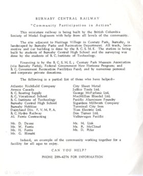
https://search.heritageburnaby.ca/link/museumartifact84655
- Repository
- Burnaby Village Museum
- Accession Code
- BV011.50.16
- Description
- Flyer; single white sheet with black text; title "BURNABY CENTRAL RAILWAY / "Community Participation in Action". Flyer promoting the Burnaby Central Railway construction and maintenance, and asking for community support. The flyer lists a number of community parters that were already involved in the project.
- Object History
- Burnaby Central Railway Project was constructed on the site of Heritage Village and was financed by the British Columbia Society of Model Engineers; Century Park Museum Association (via Burnaby Parks); Federal Government New Horizons Program and B.C. Goverment Recreation Facilities fund. British Columbia Society of Model Engineers (B.C.M.E.) operated the Burnaby Central Railway inside Heritage Village (Burnaby Village Museum) between 1975 and 1991.
- Category
- 08. Communication Artifacts
- Classification
- Advertising Media
- Object Term
- Flier
- Measurements
- w: 14 cm h: 16.5 cm
- Country Made
- Canada
- Province Made
- British Columbia
- Site/City Made
- Burnaby
- Publication Date
- [1976]
- Subjects
- Advertising Medium - Flyer
- Names
- Burnaby Village Museum
Images

flyer
https://search.heritageburnaby.ca/link/museumartifact84656
- Repository
- Burnaby Village Museum
- Accession Code
- BV011.50.17
- Description
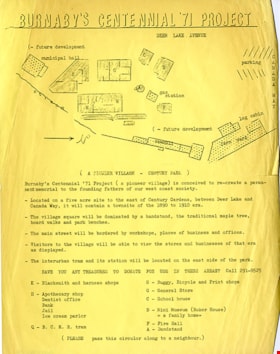
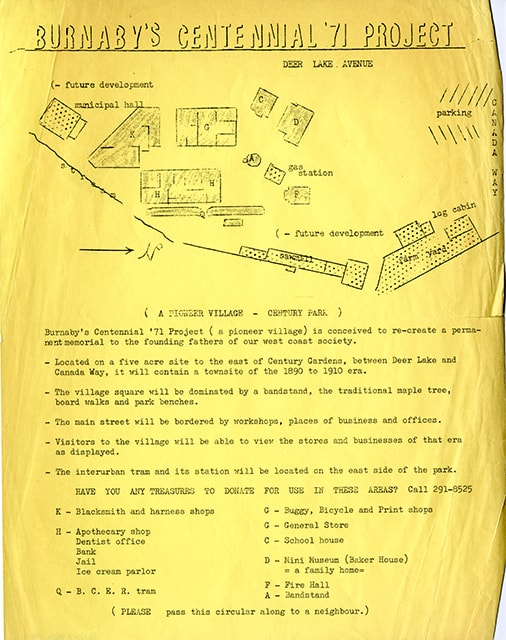
- Flyer; yellow cartridge paper with black ink; title reads: "Burnaby's Centennial '71 Project"; promoting the creation of a Pioneer Village - Century Park for the celebration of the 1971 Centennial of British Columbia joining confederation. The Flyer includes a map of the proposed site with buildings; a list of buildings to be built on the site including, Blacksmith and Harness shop, Apothecary shop, Dentist office, Bank, Jail, Ice Cream Parlour, B.C.E.R. tram, Buggy, Bicycle and Print Shops, General Store, Mini Museum (Baker house), Fire Hall and Bandstand.
- Object History
- Created by the Burnaby Centennial '71 Committee who were responsible to the creation of Heritage Village as Burnaby's Centennial legacy project.
- Category
- 08. Communication Artifacts
- Classification
- Advertising Media
- Object Term
- Flier
- Measurements
- w: 28 cm h: 21.5 cm
- Country Made
- Canada
- Province Made
- British Columbia
- Site/City Made
- Burnaby
- Title
- Burnaby's '71 Centennial Project
- Publication Date
- 1971
- Subjects
- Advertising Medium - Flyer
Images
flyer
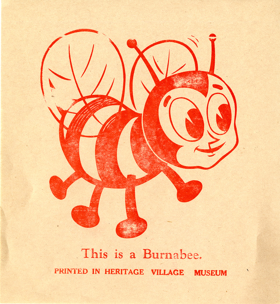
https://search.heritageburnaby.ca/link/museumartifact91039
- Repository
- Burnaby Village Museum
- Accession Code
- BV020.5.1687
- Description
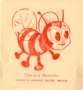
- Flyer; red ink on newsprint; illustration in red of bumblee with face; text underneath reads: "This is Burnabee. / PRINTED IN HERITAGE VILLAGE MUSEUM". [1987]
- Object History
- Programme was created by Heritage Village Print Shop and used at Heritage Village in the 1979.
- Category
- 08. Communication Artifacts
- Classification
- Documentary Artifacts - - Other Documents
- Object Term
- Flier
- Colour
- Red
- Beige
- Measurements
- 28 cm x 21.5 cm
- Maker
- Heritage Village
- Country Made
- Canada
- Province Made
- British Columbia
- Site/City Made
- Burnaby
- Subjects
- Advertising Medium - Flyer
- Names
- Burnaby Village Museum
Images