Narrow Results By
Creator
- British Columbia Hydro and Power Authority 1
- Burnaby Parks and Recreation Commission 1
- Burnaby Village Museum 9
- Burnett, David H. 1
- Burnett, Geoffrey K. 1
- Burnett & McGugan, Engineers and Surveyors 2
- Buzza, Joy 4
- Century Park Museum Association 9
- Copan, Donald (Don) 1
- Forsyth, Mary 1
- Garden, Hermon & Burwell 1
- Government of British Columbia - Department of Lands and Works 1
Person / Organization
- Aikenhead, May 7
- Air Raid Precautions (A.R.P.) 14
- Alpha Secondary School 3
- Bailey, Joan 8
- Bateman, Edwin W. 2
- Bateman Family 4
- Bayntun, Charmaine "Sherrie" Yanko 5
- Bingham, Alfred "Alf" 1
- Boy Scouts of Canada 20
- Brentwood Merchants Association 1
- Brentwood Park School 1
- British Columbia Electric Railway Company 21
![Copy of Official British Columbia Road Maps, [193-] thumbnail](/media/hpo/_Data/_BVM_Cartographic_Material/1972/1972_0179_0001_001.jpg?width=280)
Copy of Official British Columbia Road Maps
https://search.heritageburnaby.ca/link/museumdescription18945
- Repository
- Burnaby Village Museum
- Date
- [193-]
- Collection/Fonds
- Burnaby Village Museum Map collection
- Physical Description
- 1 map : lithographic print on sheet ; 43 x 56 cm folded to 22 x 11 cm
- Scope and Content
- Item consists of Road maps of British Columbia presented by Union Oil Company of Canada Limited. Includes seventeen maps printed on both sides of sheet. One side of sheet includes ten separate road maps titled "Cariboo"; "Chilcotin Plateau"; "150 Mile House to Prince George"; "Prince George - Burns…
- Repository
- Burnaby Village Museum
- Collection/Fonds
- Burnaby Village Museum Map collection
- Physical Description
- 1 map : lithographic print on sheet ; 43 x 56 cm folded to 22 x 11 cm
- Material Details
- Scale not defined
- Scope and Content
- Item consists of Road maps of British Columbia presented by Union Oil Company of Canada Limited. Includes seventeen maps printed on both sides of sheet. One side of sheet includes ten separate road maps titled "Cariboo"; "Chilcotin Plateau"; "150 Mile House to Prince George"; "Prince George - Burns Lake"; "Burns Lake - Hazelton"; "Similkameen - Nicola"; "Salmon Arm to Revelstoke"; "Ashcroft to Salmon Arm / Kamloops to Vernon"; "Okanagan Valley"; "Boundary District". Other side of sheet includes seven road maps titled "Vancouver Island"; "Vancouver to Yale"' "Fraser Canyon Section Cariboo Road"; "Lytton to 150 Mile House"; "Arrow and Kootenay Lakes"; "The Kootenays"; "Columbia Valley". When folded, cover of maps reads "COPY OF / OFFICIAL / BRITISH COLUMBIA / ROAD-MAPS" / Presented by / UNION OIL / COMPANY / of Canada Ltd."; verso of cover includes advertisement for Union Motor oil "MOTORITE"; inside cover includes advertisement for Union Gasoline with title reading "See Canada's Evergreen Playground".
- Responsibility
- Union Oil Company of Canada Limited
- Accession Code
- HV972.179.1
- Access Restriction
- No restrictions
- Reproduction Restriction
- No known restrictions
- Date
- [193-]
- Media Type
- Cartographic Material
- Scan Resolution
- 600
- Scan Date
- 2023-08-17
- Notes
- Title based on contents of map
Images
![Copy of Official British Columbia Road Maps, [193-] thumbnail](/media/hpo/_Data/_BVM_Cartographic_Material/1972/1972_0179_0001_001.jpg)

bookmark
https://search.heritageburnaby.ca/link/museumartifact91076
- Repository
- Burnaby Village Museum
- Accession Code
- BV020.5.1800
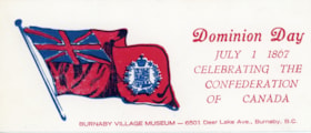
- Description
- Bookmark; red and blue ink printed on white card stock; text reads: "Dominion Day / JULY 1 1867 / CELEBRATING THE / CONFEDERATION / OF CANADA / BURNABY VILLAGE MUSEUM--6501 Deer Lake Ave., Burnaby, B.C."; image of Canadian Red Ensign flag with union Jack and emblem of provinces to left of text
- Object History
- Item was found in the Burnaby Post printshop along with other Heritage Village / Burnaby Villagee Museum ephemera that was created between 1971 and [2020]. Bookmark was printed on the Platen Press in the Burnaby Post print shop inside Burnaby Village
- Classification
- Written Communication T&E - - Writing Accessories
- Object Term
- bookmark
- Measurements
- 7.5 x 18 cm
- Maker
- Burnaby Village Museum
- Country Made
- Canada
- Province Made
- British Columbia
- Site/City Made
- Burnaby
- Publication Date
- [198-]
- Subjects
- Events
- Holidays - Canada Day
- Names
- Burnaby Village Museum
Images
Orange garland
https://search.heritageburnaby.ca/link/museumartifact91277
- Repository
- Burnaby Village Museum
- Accession Code
- BV021.20.1
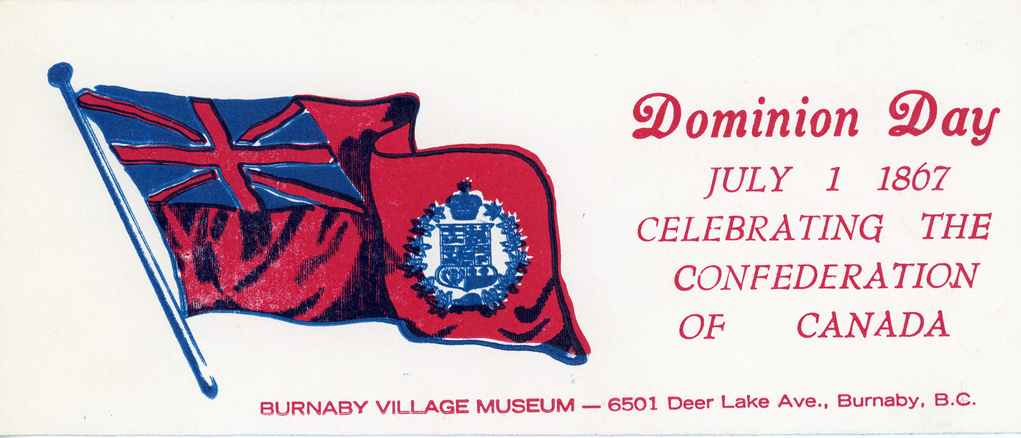
- Description
- The garland consist of several hundred small pieces of orange fabric in different patterns and shades. They are tied around the base, a thin white rope.
- Object History
- These items were collected as part of the Museum's response to the news of 215 unmarked children's graves found at the Kamloops Residential School in June 2021. These items came from engagement activities the public were invited to take part in for several weeks and consider the impact of the discovery in their own lives.
- This garland was built by members of the public tying an orange piece of fabric to a string. These garlands lined the Cedar Grove in the Village.
- There were a number of other elements to the commemorative display at the Museum. At the Church, there was a display of children's shoes and poetry. Visitors were invited to reflect and write a message to the children, the families or anyone connected to this tragic finding. Visitors were invited to write a message on an orange index card.
- Category
- 08. Communication Artifacts
- Classification
- Ceremonial Artifacts
- Object Term
- Garland
- Colour
- Orange
- Measurements
- height: 362 cm width: 10 cm depth: 1cm
- Country Made
- Canada
- Province Made
- British Columbia
- Site/City Made
- Burnaby
Images

Graphic Map and Street Guide of Vancouver British Columbia / Graphic Publishers Canada
https://search.heritageburnaby.ca/link/archivedescription46977
- Repository
- City of Burnaby Archives
- Date
- [ca. 1950]
- Collection/Fonds
- Burnaby Historical Society fonds
- Description Level
- Item
- Physical Description
- 1 map
- Scope and Content
- Map and street guide of Vancouver, including North Vancouver, West Vancouver, Burnaby, New Westminster and Lulu Island. Map also includes an index of parks, schools, hospitals and other places of interest.
- Repository
- City of Burnaby Archives
- Date
- [ca. 1950]
- Collection/Fonds
- Burnaby Historical Society fonds
- Subseries
- Ephemera subseries
- Physical Description
- 1 map
- Description Level
- Item
- Record No.
- 37274
- Accession Number
- 2008-19
- Scope and Content
- Map and street guide of Vancouver, including North Vancouver, West Vancouver, Burnaby, New Westminster and Lulu Island. Map also includes an index of parks, schools, hospitals and other places of interest.
- Media Type
- Cartographic Material
Map of Dominion of Canada
https://search.heritageburnaby.ca/link/museumdescription11396
- Repository
- Burnaby Village Museum
- Date
- [1932]
- Collection/Fonds
- Burnaby Village Museum Map collection
- Description Level
- Item
- Physical Description
- 1 map : col. ink on paper ; 50 x 88 cm on paper 58.5 x 96 cm
- Scope and Content
- Item consists of "Map of the Dominion of Canada" produced by the Department of the Interior and the National Development Bureau in 1932. The map includes information about the railway lines in operation and under construction for the Canadian National Railways, Canadian Pacific Railways, and other …
- Repository
- Burnaby Village Museum
- Collection/Fonds
- Burnaby Village Museum Map collection
- Description Level
- Item
- Physical Description
- 1 map : col. ink on paper ; 50 x 88 cm on paper 58.5 x 96 cm
- Material Details
- Scale 100 miles = 1 inch
- Scope and Content
- Item consists of "Map of the Dominion of Canada" produced by the Department of the Interior and the National Development Bureau in 1932. The map includes information about the railway lines in operation and under construction for the Canadian National Railways, Canadian Pacific Railways, and other railways. The map also includes Steamship Routes with distances included.
- Accession Code
- BV006.24.20
- Access Restriction
- No restrictions
- Reproduction Restriction
- May be restricted by third party rights
- Date
- [1932]
- Media Type
- Cartographic Material
- Notes
- Transcribed title
Map of the Dominion of Canada
https://search.heritageburnaby.ca/link/museumdescription18944
- Repository
- Burnaby Village Museum
- Date
- 1911
- Collection/Fonds
- Burnaby Village Museum Map collection
- Description Level
- Item
- Physical Description
- 1 map : col. lithographic print on white paper ; 49.5 x 88.5 cm on sheet 63.5 x 90.5 cm
- Scope and Content
- Item consists of a "MAP OF THE DOMINION OF CANADA" produced by the Department of the Interior in 1911 . Text in lower border below map reads "THIS MAP IS PRESENTED WITH THE COMPLIMENTS OF THE ROYAL BANK OF CANADA" "WITH ITS FORTY-SECOND ANNUAL REPORT, 31st DECEMBER, 1911" at bottom centre, with lis…
- Repository
- Burnaby Village Museum
- Collection/Fonds
- Burnaby Village Museum Map collection
- Description Level
- Item
- Physical Description
- 1 map : col. lithographic print on white paper ; 49.5 x 88.5 cm on sheet 63.5 x 90.5 cm
- Material Details
- Scale: 100 miles = 1 inch
- Scope and Content
- Item consists of a "MAP OF THE DOMINION OF CANADA" produced by the Department of the Interior in 1911 . Text in lower border below map reads "THIS MAP IS PRESENTED WITH THE COMPLIMENTS OF THE ROYAL BANK OF CANADA" "WITH ITS FORTY-SECOND ANNUAL REPORT, 31st DECEMBER, 1911" at bottom centre, with list of branches in Canada and in other countries; at left is list of "PRINCIPAL FOREIGN CORRESPONDENTS"; at right is general information, "INCORPORATED 1869", "HEAD OFFICE MONTREAL", with "CAPITAL PAID UP", "RESERVE FUNDS", "AGGREGATE ASSETS" all listed, and "BOARD OF DIRECTORS" listed. Map shows proposed additions to Quebec, Ontario and Manitoba. Provincial and territorial borders, shipping routes, railway lines are identified. Two charts at upper right of distances, red print, one for distances in Canada from Montreal, the other for Montreal, Halifax and Churchill to foreign ports.
- Publisher
- Royal Bank of Canada
- Accession Code
- BV988.56.4
- Access Restriction
- No restrictions
- Reproduction Restriction
- No known restrictions
- Date
- 1911
- Media Type
- Cartographic Material
- Notes
- Title based on contents of map

Subdivision plans in New Westminster District Group 1 – Burnaby, Vancouver and map - Canada Department of Mines
https://search.heritageburnaby.ca/link/museumdescription6994
- Repository
- Burnaby Village Museum
- Date
- 1890-1909
- Collection/Fonds
- Burnaby Village Museum Map collection
- Description Level
- File
- Physical Description
- 1 plan : graphite on paper + 2 plans : black ink on paper + 1 map : col. on paper mounted on 2 sides of cardboard 76 x 102 cm
- Scope and Content
- Item consists of a large board with one New Westminster District subdivision plan mounted on one side and two New Westminster District subdivision plans and one colour map mounted on the other side. Side A: 1. "Plan / of Subdivision of / Blocks 2, 3, 4, 5, 6 / Lot 77 / Group 1 / New Westminster D…
- Repository
- Burnaby Village Museum
- Collection/Fonds
- Burnaby Village Museum Map collection
- Description Level
- File
- Physical Description
- 1 plan : graphite on paper + 2 plans : black ink on paper + 1 map : col. on paper mounted on 2 sides of cardboard 76 x 102 cm
- Material Details
- Scales 1:720 and 1:1200 and 1:.00001578
- Scope and Content
- Item consists of a large board with one New Westminster District subdivision plan mounted on one side and two New Westminster District subdivision plans and one colour map mounted on the other side. Side A: 1. "Plan / of Subdivision of / Blocks 2, 3, 4, 5, 6 / Lot 77 / Group 1 / New Westminster District / BC. / Scale 100 feet = 1 inch", "Deposited 8th day / of April 1890 / Mowileg [sic] / Dist. Regt". Plan is drawn in graphite with annotations: "AB_Parts_lettered_are_lots_in / the_different_subdivisions" / "Owners: / James E. Hall / P.S.Cabilan [sic] by his attorney Joseph Hall / Joseph Hall / Eliza J. Shannon / John Harrison"; "This plan is correct and is prepared under the / provisions of the Land Registry Act" ; signed by: "Gordon Herman & Burwell / Dominion & Provincial Land Surveryors / Vancouver March 19th/90" . Plan is initialed by: "RB" [sic] (in blue pencil crayon) and measures: 99.5 x 65 cm (Geographic location: Burnaby) Side B: 1. Map titled "Canada / Department of Mines / Geological Survey Branch" / "Hon.W Templeton, Minister / A.P. Low, Deputy Minister / R.W. Brock, Acting Director", Vol. XXXI, Plate I / Compiled under the direction of / James White, F.R.G.S. Geographer /Dep. of Interior". Note above map reads: "To illustrate Mr. James Barrowman's report as Delegate at the Excursion - meeting of the Canadian Mining Institute", "The instiitution of Mining Engineers / Transactions 1908 - 1909", "The Mining Institute of Scotland / Transactions 1908-1909". Map identifies minerals and includes a Legend and Scale: 100 miles = 1 inch 2. "Plan / of Subdivision of / Lot 4 / of Subdivision of / Lot 87. Gr. 1 / New Westminster District / Scale 60' = 1in." Plan is initialed by: "RB" [sic] along with a note "also Board / 48" (in blue pencil crayon) (Geographic location: Burnaby) 3. Plan of "Lot 335 / G. 1" west of Boundary Road and north of River Road - Vancouver. (Geographic location: Vancouver)
- Publisher
- The Mining Institute of Scotland
- Geographic Access
- Vancouver
- Accession Code
- HV977.93.25
- Access Restriction
- No restrictions
- Reproduction Restriction
- No known restrictions
- Date
- 1890-1909
- Media Type
- Cartographic Material
- Scan Resolution
- 300
- Scale
- 72
- Notes
- Title based on contents of file
- Scale is measured in feet and miles.
- The term "Lot" often refers to "District Lot"
Images


Western Canada Power Company
https://search.heritageburnaby.ca/link/archivedescription395
- Repository
- City of Burnaby Archives
- Date
- 1909-1930
- Collection/Fonds
- City Council and Office of the City Clerk fonds
- Description Level
- File
- Physical Description
- 5 folders textual records and cartographic material
- Scope and Content
- File contains draft bylaws, draft contracts and correspondence related to the operation of the Western Canada Power Company. As well, file contains declarations, news clippings, correspondence, ballots, and tally sheets that resulted from the voting held regarding the Western Canada Power Co. Byla…
- Repository
- City of Burnaby Archives
- Date
- 1909-1930
- Collection/Fonds
- City Council and Office of the City Clerk fonds
- Physical Description
- 5 folders textual records and cartographic material
- Description Level
- File
- Record No.
- 2091
- Accession Number
- 2001-02
- Scope and Content
- File contains draft bylaws, draft contracts and correspondence related to the operation of the Western Canada Power Company. As well, file contains declarations, news clippings, correspondence, ballots, and tally sheets that resulted from the voting held regarding the Western Canada Power Co. Bylaw. Also included are agreements, correspondence and bylaw no. 114. The 1922 agreement includes a blueprint. As well, file contains a white linen plan of DL 15 and blueprint plans of standard power pole and transmission towers on Broadway and Cariboo Roads, 1916.
- Media Type
- Textual Record
- Cartographic Material
- Notes
- For related records see also file 6-1-5-2. A map of the Municipality of Burnaby by Archibald Moir and Co. : M9-B-2-11; blueprint of Burnaby Municipality : M9-B-2-15
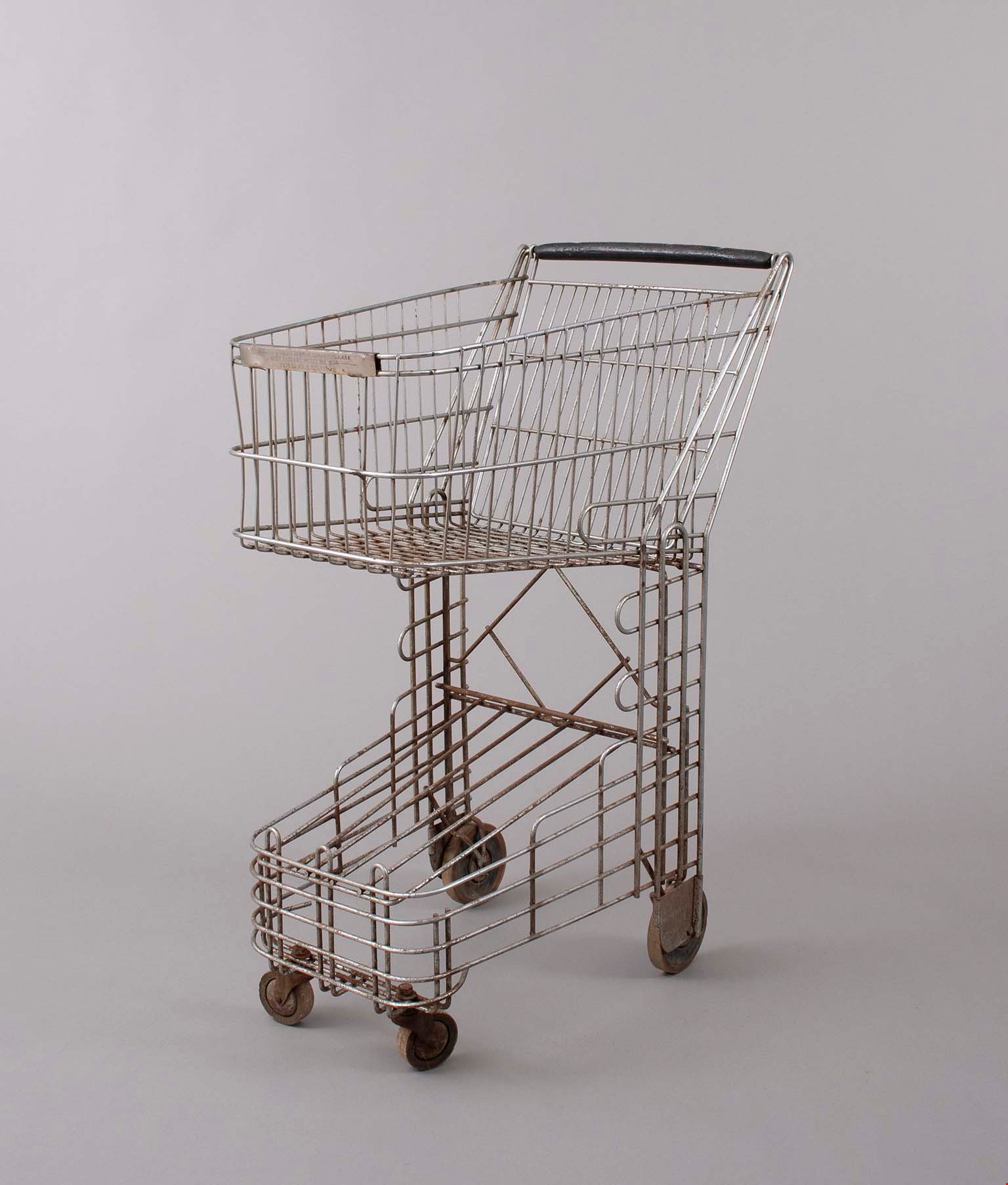
cart
https://search.heritageburnaby.ca/link/museumartifact91781
- Repository
- Burnaby Village Museum
- Accession Code
- BV023.17.1
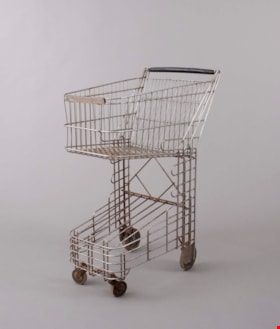
- Description
- Small grocery or shopping cart. The cart was produced by Folding Carrier Corporation of Oklahoma. This cart is called the Nest Baskart which features a levered back panel to easily nest multiple carts together when not in use.
- The body of the cart is formed by metal spokes welded together to form a cage like pattern.
- The top of the cart has a large basket like area for holding items. The bottom of the cart has a sloped shelf that could have held another removable basket.
- The handle of the cart is covered in a hard black material, possibly hardened rubber or plastic.
- The cart features curved corners along the top and bottom of the basket area.
- The cart has four wheels, the back two are fixed and the front two are
- Object History
- Item was used in the Canada Way Food Market owned by Harry Toy between 1975 and the late 2000s. the building sat vacant until sold in 2023.
- Cart was used by donor to restock shelves when not in use by customers.
- Classification
- Merchandising T&E
- Object Term
- Cart, Shopping
- Marks/Labels
- "FOLDING CARRIER CORP. OKLAHOMA CITY, OKLA., U.S.A. / NEST BASKART, MODEL WK 1200 / PATENT NO. 2,479,530"
- Subjects
- Persons - Chinese Canadians
- Names
- Canada Way Food Market
- Geographic Access
- Canada Way
- Street Address
- 4692 Canada Way
Images
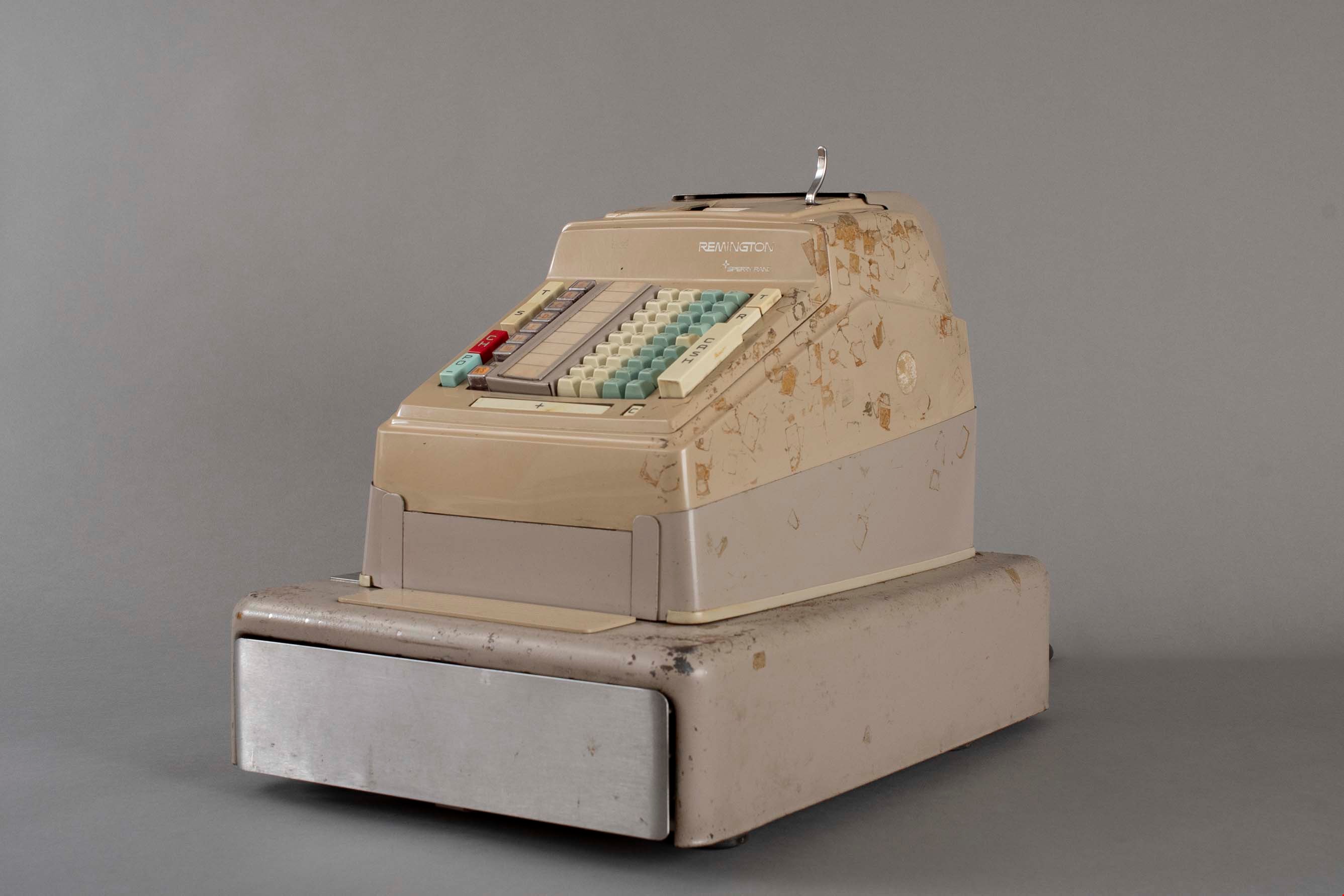
cash register
https://search.heritageburnaby.ca/link/museumartifact91785
- Repository
- Burnaby Village Museum
- Accession Code
- BV023.17.5
- Description
- Cash register, cash drawer, adding machine made by Remington Sperry Rand.
- It has four columns of keys for dollars and cents, three additional columns of digit keys, and three columns of keys with various functions on them. An addition bar and cancel button are across the base, and a paper tape at the top.
- Sales are not displayed visually by any indicator.
- There is a metal cash drawer that has plastic divisions for change and cash.
- There is a key that slots into a lock on the left side that controls the machine with a lever.
- The register is made of metal and plastic components.
- Object History
- Item was used in the Canada Way Food Market owned by Harry Toy between 1975 and the late 2000s. the building sat vacant until sold in 2023.
- Cash register was used daily in the Canada Way Food Market.
- Classification
- Merchandising T&E
- Object Term
- Register, Cash
- Maker
- Remington
- Subjects
- Persons - Chinese Canadians
- Names
- Canada Way Food Market
- Geographic Access
- Canada Way
- Street Address
- 4692 Canada Way
Images
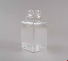
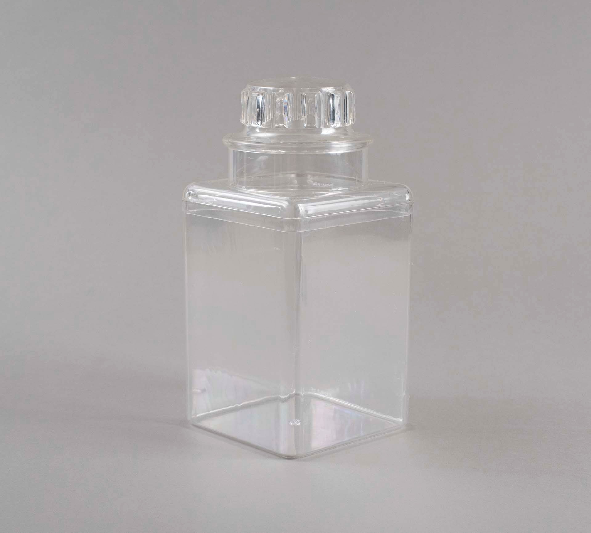
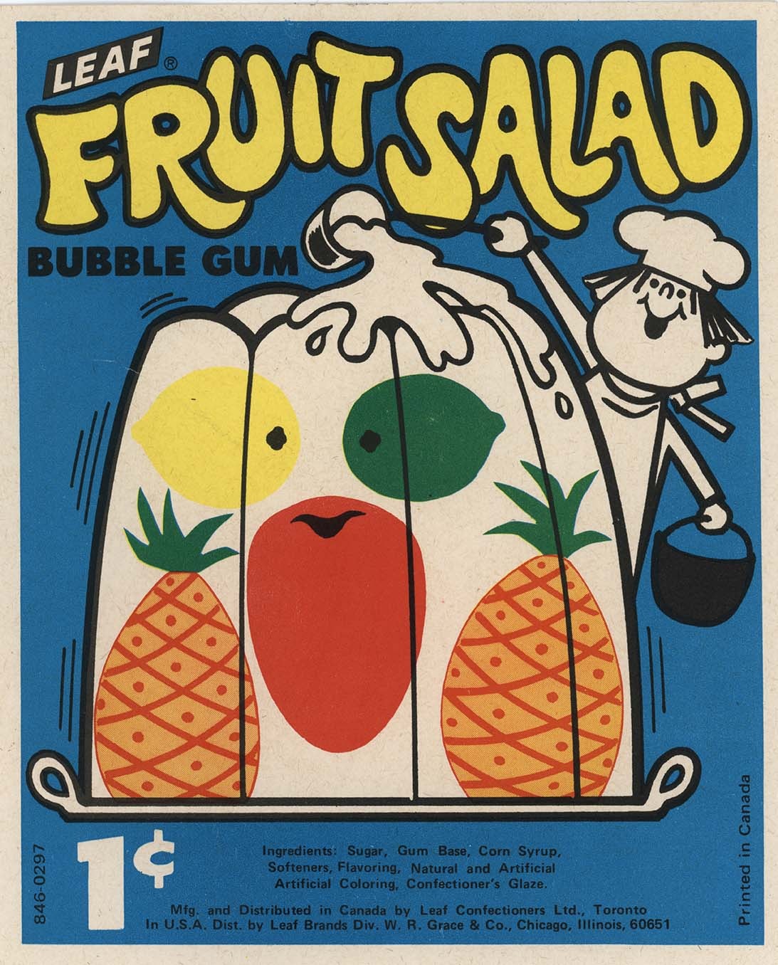
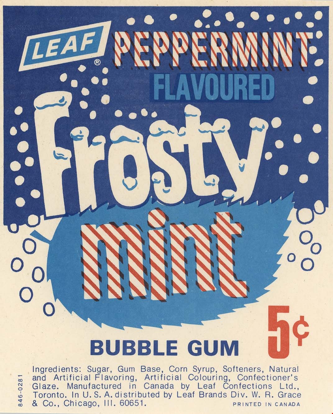
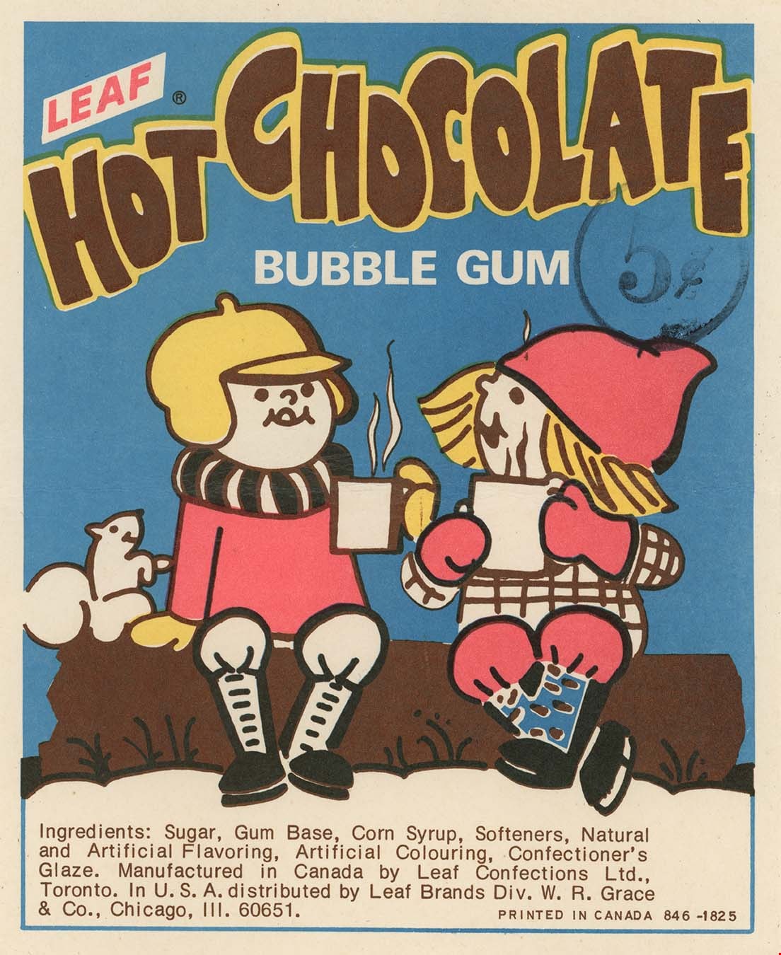
container
https://search.heritageburnaby.ca/link/museumartifact91787
- Repository
- Burnaby Village Museum
- Accession Code
- BV023.17.7
- Description
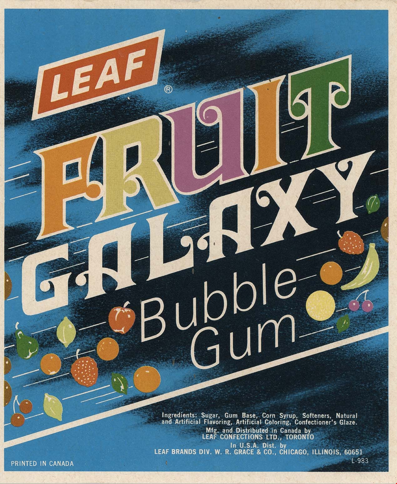
- Clear plastic containers used for selling 5 cent candy. The containers are rectangular in shape with a lid designed to look like a glass jar lid but actually opens much further down than expected.
- Inside the container was a product label advertising the type of bubble gum the container held.
- Object History
- Item was used in the Canada Way Food Market owned by Harry Toy between 1975 and the late 2000s. the building sat vacant until sold in 2023.
- Classification
- Container
- Object Term
- Canister, Food Storage
- Subjects
- Persons - Chinese Canadians
- Container
- Names
- Canada Way Food Market
- Geographic Access
- Canada Way
- Street Address
- 4692 Canada Way
Images
container
https://search.heritageburnaby.ca/link/museumartifact91788
- Repository
- Burnaby Village Museum
- Accession Code
- BV023.17.8
- Description
- Clear plastic containers used for selling 5 cent candy. The containers are rectangular in shape with a lid designed to look like a glass jar lid but actually opens much further down than expected.
- Inside the container was a product label advertising the type of bubble gum the container held.
- Object History
- Item was used in the Canada Way Food Market owned by Harry Toy between 1975 and the late 2000s. the building sat vacant until sold in 2023.
- Classification
- Container
- Object Term
- Canister, Food Storage
- Subjects
- Persons - Chinese Canadians
- Container
- Names
- Canada Way Food Market
- Geographic Access
- Canada Way
- Street Address
- 4692 Canada Way
Images
container
https://search.heritageburnaby.ca/link/museumartifact91789
- Repository
- Burnaby Village Museum
- Accession Code
- BV023.17.9
- Description
- Clear plastic containers used for selling 5 cent candy. The containers are rectangular in shape with a lid designed to look like a glass jar lid but actually opens much further down than expected.
- Inside the container was a product label advertising the type of bubble gum the container held.
- Object History
- Item was used in the Canada Way Food Market owned by Harry Toy between 1975 and the late 2000s. the building sat vacant until sold in 2023.
- Classification
- Container
- Object Term
- Canister, Food Storage
- Subjects
- Persons - Chinese Canadians
- Container
- Names
- Canada Way Food Market
- Geographic Access
- Canada Way
- Street Address
- 4692 Canada Way
Images
container
https://search.heritageburnaby.ca/link/museumartifact91790
- Repository
- Burnaby Village Museum
- Accession Code
- BV023.17.10
- Description
- Clear plastic containers used for selling 5 cent candy. The containers are rectangular in shape with a lid designed to look like a glass jar lid but actually opens much further down than expected.
- Inside the container was a product label advertising the type of bubble gum the container held.
- Object History
- Item was used in the Canada Way Food Market owned by Harry Toy between 1975 and the late 2000s. the building sat vacant until sold in 2023.
- Classification
- Container
- Object Term
- Canister, Food Storage
- Subjects
- Persons - Chinese Canadians
- Container
- Names
- Canada Way Food Market
- Geographic Access
- Canada Way
- Street Address
- 4692 Canada Way
Images

Douglas Road School site
https://search.heritageburnaby.ca/link/museumdescription11136
- Repository
- Burnaby Village Museum
- Date
- April 19, 1915
- Collection/Fonds
- Ronald G. Scobbie collection
- Description Level
- Item
- Physical Description
- 1 survey plan : blueprint on paper ; 56 x 54 cm
- Scope and Content
- Survey plan of "Douglas Road School Site / Burnaby Municipality" "Being Lot 21, of Blocks 1-5 inc. 11 & 12 of the subd. of north half of Lot 80, Group 1, New Westminster District".
- Repository
- Burnaby Village Museum
- Collection/Fonds
- Ronald G. Scobbie collection
- Description Level
- Item
- Physical Description
- 1 survey plan : blueprint on paper ; 56 x 54 cm
- Material Details
- Scale 40 feet = 1 inch
- Scope and Content
- Survey plan of "Douglas Road School Site / Burnaby Municipality" "Being Lot 21, of Blocks 1-5 inc. 11 & 12 of the subd. of north half of Lot 80, Group 1, New Westminster District".
- Creator
- McGugan, Donald Johnston
- Subjects
- Buildings - Schools
- Names
- Douglas Road School
- Responsibility
- Burnett & McGugan, Engineers and Surveyors
- Geographic Access
- Canada Way
- Street Address
- 4861 Canada Way
- Accession Code
- BV003.83.15
- Access Restriction
- No restrictions
- Reproduction Restriction
- No known restrictions
- Date
- April 19, 1915
- Media Type
- Cartographic Material
- Historic Neighbourhood
- Burnaby Lake (Historic Neighbourhood)
- Planning Study Area
- Douglas-Gilpin Area
- Scan Resolution
- 440
- Scan Date
- 22-Dec-2020
- Scale
- 100
- Notes
- Title based on contents of plan
- Note in black ink on verso of plan reads: "1747"
- Oath on plan reads: "I, D.G. McGugan..." "...and did person- ally superintend the survey..." "...completed on the 3rd day of April 1915"; signed by D.J. McGugan, notarized by "H.A. Eastman", sworn "...19th day of April 1915" "Burnett and McGugan" "B.C. Land Surveyors Etc. New Westminster, B.C.."
Images

milk crate
https://search.heritageburnaby.ca/link/museumartifact91786
- Repository
- Burnaby Village Museum
- Accession Code
- BV023.17.6
- Description
- Light grey plastic milk crate produced for Silverwood's Dairy of Ontario.
- The plastic is formed in a diamond cut out pattern and has handles on two sides.
- There are various imprinted texts throughout.
- The top of the crate is scuffed an dirty
- Object History
- Item was used in the Canada Way Food Market owned by Harry Toy between 1975 and the late 2000s. the building sat vacant until sold in 2023.
- Classification
- Container
- Object Term
- Crate
- Marks/Labels
- "PROPERTY OF / SILVERWOOD'S"
- "MISUSER OF / THIS CASE / IS LIABLE TO / PROSECUTION"
- "G H J INDUSTRIES LTD / MADE IN CANADA BY GHJ IND / PATEND PENDING"
- "WARNING / USE BY OTHER THAN REGISTERED OWNER PROHIBITED BY LAW"
- Measurements
- Height: 27.5 cm
- Width: 33 cm
- Depth: 33 cm
- Subjects
- Persons - Chinese Canadians
- Container
- Names
- Canada Way Food Market
- Geographic Access
- Canada Way
- Street Address
- 4692 Canada Way
Images
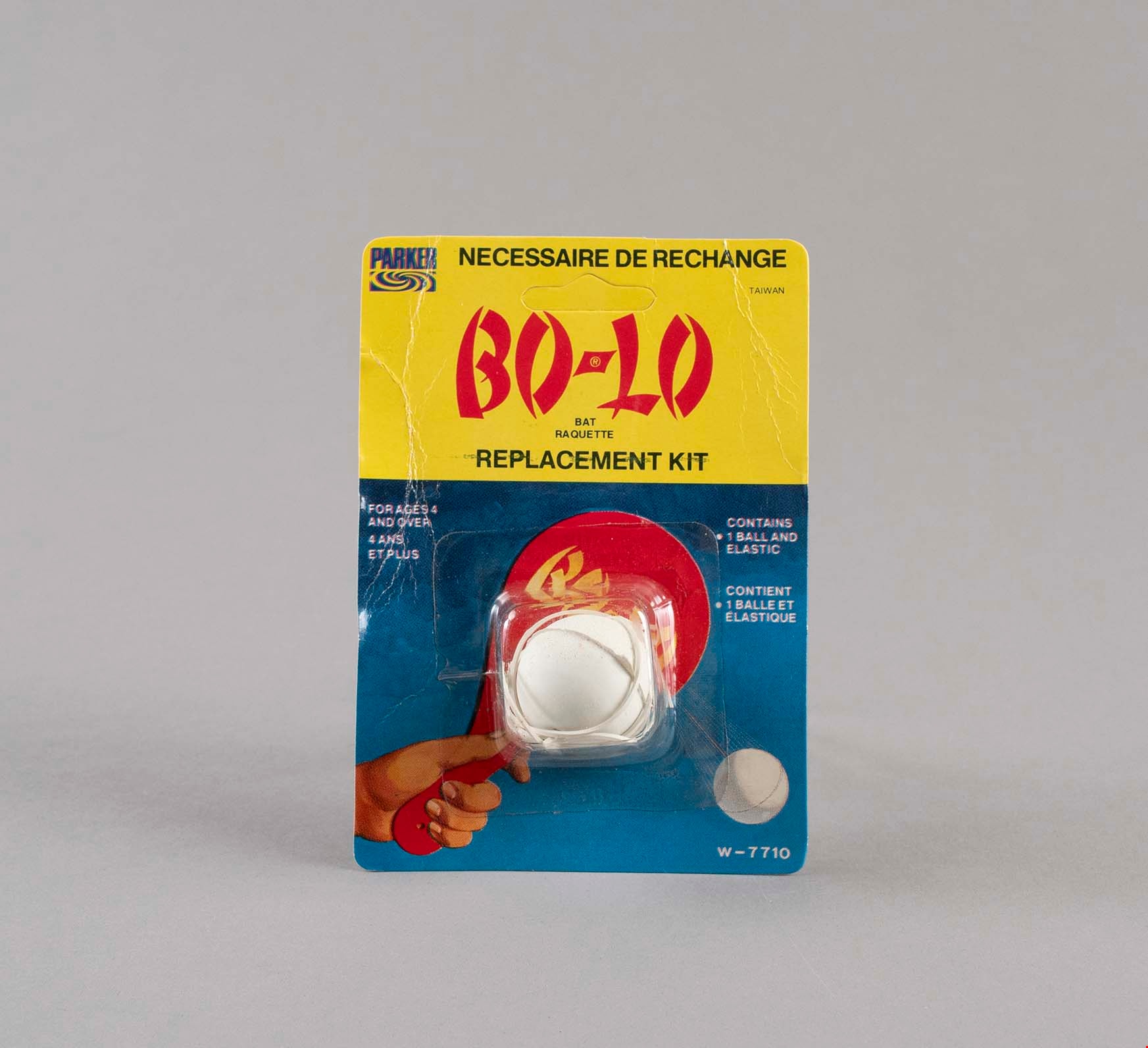
paddle ball replacement
https://search.heritageburnaby.ca/link/museumartifact91791
- Repository
- Burnaby Village Museum
- Accession Code
- BV023.17.11
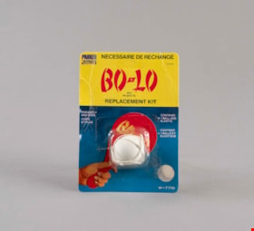
- Description
- Paddle ball replacement kit including product packaging.
- The product is produced by Parker Brothers under the Bo-Lo trademark brand.
- The package is cardboard with a plastic shell containing a rubber ball and elastic band.
- The cardboard has a thick band of yellow above a gradient blue background. There is an illustration of a red Bo-Lo paddle ball.
- The back side of the package includes instructions for installing the new ball onto a paddle.
- The package is slightly damaged with creases along the cardboard and brown spotting on the back.
- Object History
- Item was used in the Canada Way Food Market owned by Harry Toy between 1975 and the late 2000s. the building sat vacant until sold in 2023.
- Category
- 09. Recreational Artifacts
- Classification
- Game Equipment
- Object Term
- Game
- Marks/Labels
- "BO-LO / BAT / RAQUETTE / REPLACEMENT KIT"
- Measurements
- Height: 14.5 cm
- Width: 10.5 cm
- Subjects
- Persons - Chinese Canadians
- Games
- Names
- Canada Way Food Market
- Geographic Access
- Canada Way
- Street Address
- 4692 Canada Way
Images
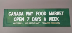
sign
https://search.heritageburnaby.ca/link/museumartifact91782
- Repository
- Burnaby Village Museum
- Accession Code
- BV023.17.2
- Description
- Green store sign from Canada Way Food Market. Plasticized green sign with white lettering.
- There is a 2.5 cm band of residue running the length of the sign at the top and bottom.
- Object History
- Item was used in the Canada Way Food Market owned by Harry Toy between 1975 and the late 2000s. the building sat vacant until sold in 2023.
- Category
- 08. Communication Artifacts
- Classification
- Advertising Media
- Object Term
- Sign, Advertising
- Marks/Labels
- "CANADA WAY FOOD MARKET / OPEN 7 DAYS A WEEK / GROCERIES CONFECTIONARY TOBACCO PRODUCTS"
- Measurements
- Height: 49.5 cm
- Width: 176.5
- Names
- Canada Way Food Market
- Geographic Access
- Canada Way
- Street Address
- 4692 Canada Way
Images
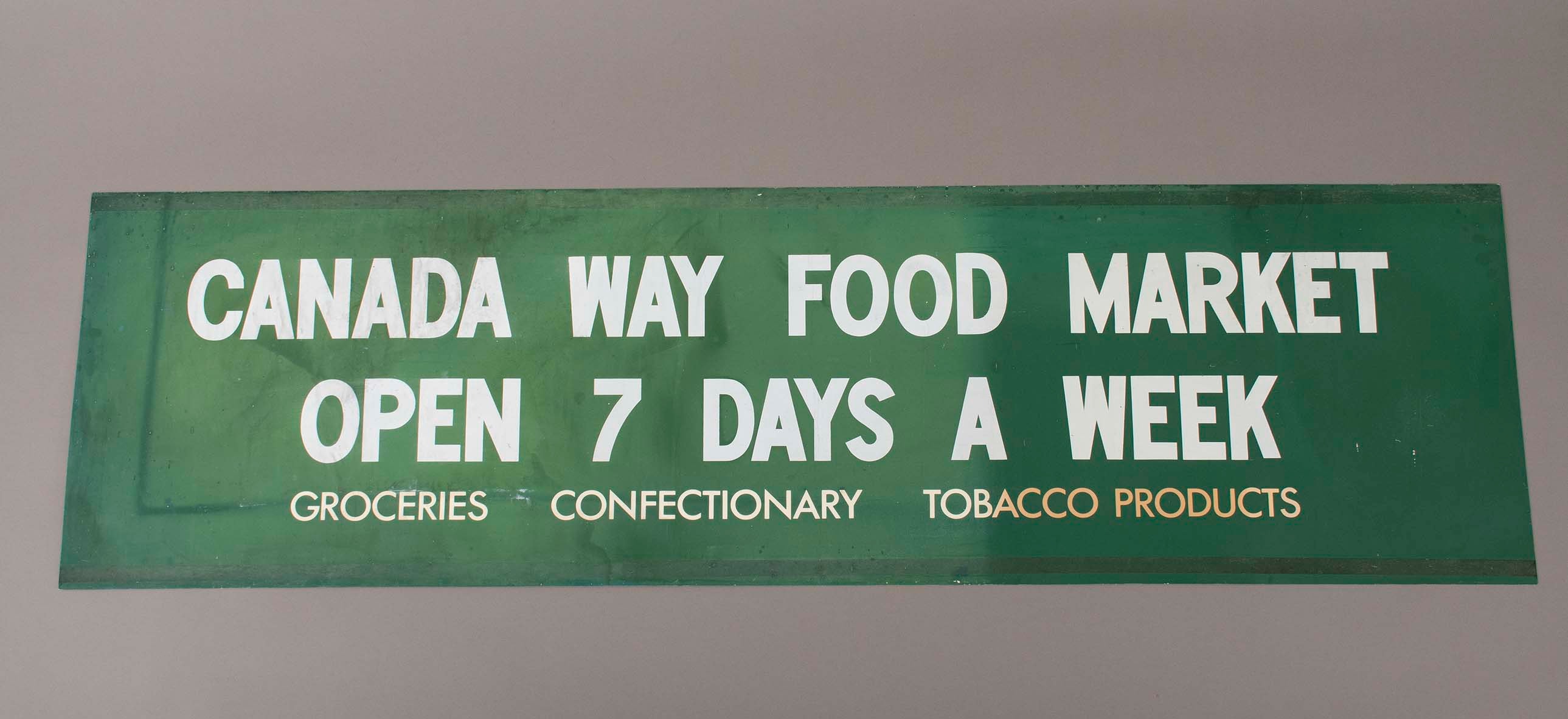
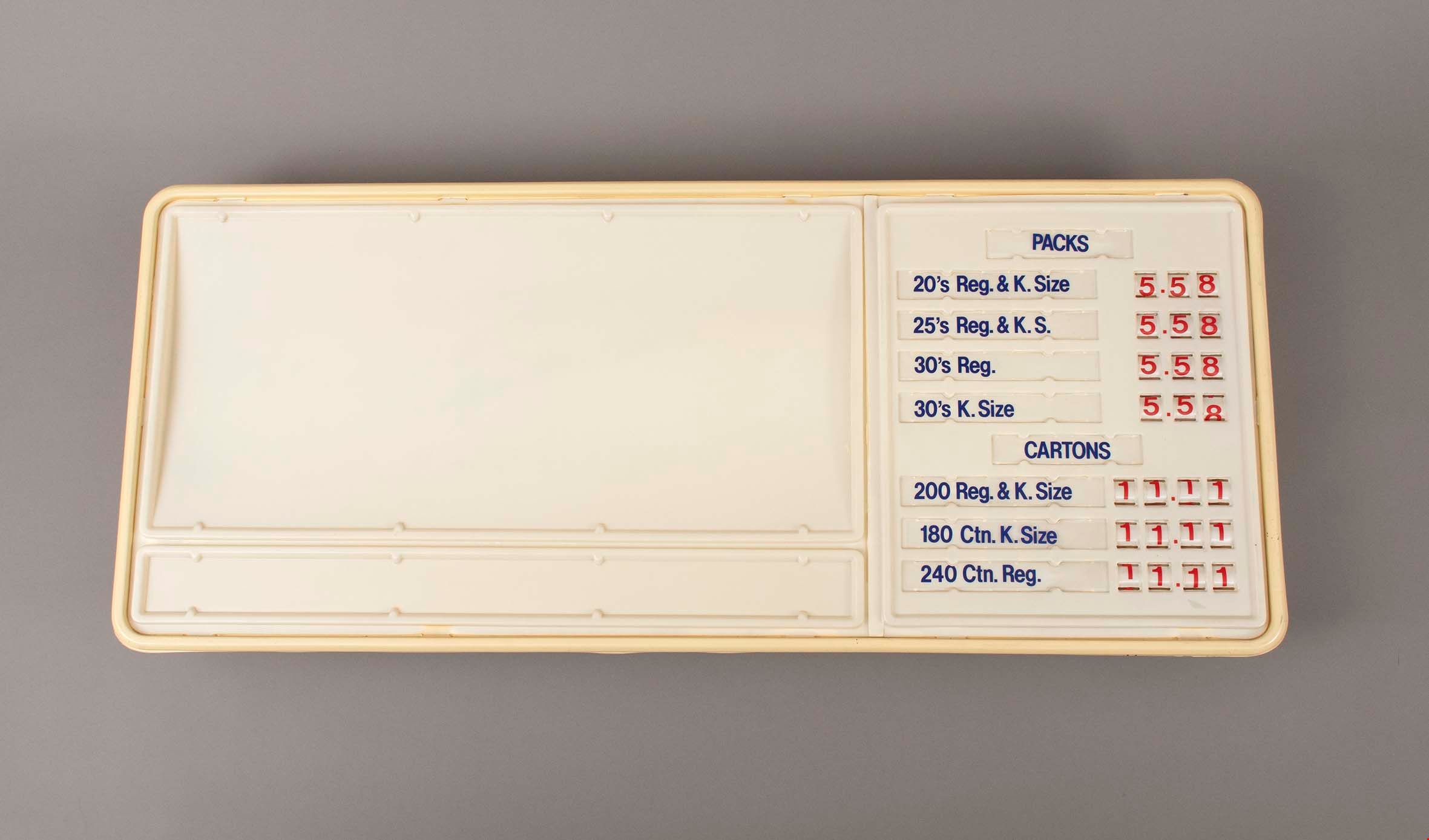
sign
https://search.heritageburnaby.ca/link/museumartifact91783
- Repository
- Burnaby Village Museum
- Accession Code
- BV023.17.3
- Description
- Large plastic sign with internal backlighting for advertising. The sign has two sections for ad inserts and one section for price display.
- The price display is currently set up advertising the price of packs and cartons of cigarettes
- The first bank of prices are 3 digit with small windows that reveal the number on a roller behind. The second bank of prices are 4 digits.
- The sign was made by CDA Industries in Scarborough, Ontario and is stamped with "JULY 1986"
- There are three labels at the top of the sign including information about how to replace the lamps or reinsert unrolled numbers.
- There is a hole at the top of the sign for the electrical cord to come out.
- There are two white metal brackets attached to the ends of the sign and there is a rusted chain hanging from each bracket.
- The plastic at the bottom right corner on the back is broken and damaged.
- Object History
- Item was used in the Canada Way Food Market owned by Harry Toy between 1975 and the late 2000s. the building sat vacant until sold in 2023.
- See BV023.25.1 for photograph of sign in situ.
- Category
- 08. Communication Artifacts
- Classification
- Advertising Media
- Object Term
- Sign, Advertising
- Marks/Labels
- "PACKS / 20's Reg. & K. Size 5.58 / 25's Reg. & K.S. 5.58 / 30's Reg. 5.58 / 30's K. Size 5.58"
- "CARTONS / 200 Reg. & K.Size 11.11 / 180 Ctn. K. Size 11.11 / 240 Ctn. Reg. 11.11"
- Measurements
- Height: 57.5 cm
- Width: 133.5 cm
- Depth: 13 cm
- Names
- Canada Way Food Market
- Geographic Access
- Canada Way
- Street Address
- 4692 Canada Way
Images
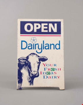
sign
https://search.heritageburnaby.ca/link/museumartifact91784
- Repository
- Burnaby Village Museum
- Accession Code
- BV023.17.4
- Description
- Wooden sandwich board advertising Dairyland products. The board consists of two wooden panels that were attached at the top with a piano hinge. The hinge is currently only attached to one panel. The wooden panels are painted white. The paint is chipping in many areas.
- Both panels feature the same information and have an large illustration of a cow's head an front body on the bottom left.
- The two panels are held together on the back with a rusty metal chain.
- Handwritten on the back of one of the panels is "Canada Way Food Market"
- Object History
- Item was used in the Canada Way Food Market owned by Harry Toy between 1975 and the late 2000s. the building sat vacant until sold in 2023.
- Category
- 08. Communication Artifacts
- Classification
- Advertising Media
- Object Term
- Sign, Advertising
- Marks/Labels
- "OPEN / Dairyland / Your / Fresh / Ideas / Dairy"
- Measurements
- Height: 74.5 cm
- Width: 49 cm
- Names
- Canada Way Food Market
- Geographic Access
- Canada Way
- Street Address
- 4692 Canada Way
Images
