Narrow Results By
Subject
- Advertising Medium 1
- Advertising Medium - Signs and Signboards 22
- Buildings - Commercial 1
- Buildings - Commercial - Grocery Stores 4
- Buildings - Commercial - Malls 1
- Buildings - Commercial - Restaurants 4
- Buildings - Commercial - Service Stations 3
- Buildings - Commercial - Stores 1
- Buildings - Recreational - Community Halls 1
- Buildings - Religious - Churches 1
- Buildings - Residential 1
- Events 1

A & Aero Trading Salvage
https://search.heritageburnaby.ca/link/archivedescription79166
- Repository
- City of Burnaby Archives
- Date
- October 16, 1976
- Collection/Fonds
- Burnaby Public Library Contemporary Visual Archive Project
- Description Level
- Item
- Physical Description
- 1 photograph : b&w ; 11 x 16 cm mounted on cardboard
- Scope and Content
- Photograph shows a large sign advertising lawn mower sharpening over A & Aero Trading Salvage at 6147 Hastings Street.
- Repository
- City of Burnaby Archives
- Date
- October 16, 1976
- Collection/Fonds
- Burnaby Public Library Contemporary Visual Archive Project
- Physical Description
- 1 photograph : b&w ; 11 x 16 cm mounted on cardboard
- Description Level
- Item
- Record No.
- 556-184
- Access Restriction
- No restrictions
- Reproduction Restriction
- Reproduce for fair dealing purposes only
- Accession Number
- 2013-13
- Scope and Content
- Photograph shows a large sign advertising lawn mower sharpening over A & Aero Trading Salvage at 6147 Hastings Street.
- Names
- A & Aero Trading Salvage
- Media Type
- Photograph
- Notes
- Scope note taken directly from BPL photograph description.
- 1 b&w copy negative : 10 x 12.5 cm accompanying
- Photographers identified by surnames only: Carr and Vardeman
- Geographic Access
- Hastings Street
- Street Address
- 6147 Hastings Street
- Historic Neighbourhood
- Lochdale (Historic Neighbourhood)
- Planning Study Area
- Westridge Area
Images


Advertising Signs
https://search.heritageburnaby.ca/link/archivedescription79154
- Repository
- City of Burnaby Archives
- Date
- November 1, 1976
- Collection/Fonds
- Burnaby Public Library Contemporary Visual Archive Project
- Description Level
- Item
- Physical Description
- 1 photograph : b&w ; 11 x 16 cm mounted on cardboard
- Scope and Content
- Photograph shows signs advertising Musgrove Ford Ltd. and Burnaby Cleaners on top of the building which housed Burnaby Cleaners at 4429 Hastings Street.
- Repository
- City of Burnaby Archives
- Date
- November 1, 1976
- Collection/Fonds
- Burnaby Public Library Contemporary Visual Archive Project
- Physical Description
- 1 photograph : b&w ; 11 x 16 cm mounted on cardboard
- Description Level
- Item
- Record No.
- 556-178
- Access Restriction
- No restrictions
- Reproduction Restriction
- Reproduce for fair dealing purposes only
- Accession Number
- 2013-13
- Scope and Content
- Photograph shows signs advertising Musgrove Ford Ltd. and Burnaby Cleaners on top of the building which housed Burnaby Cleaners at 4429 Hastings Street.
- Names
- Burnaby Cleaners
- Media Type
- Photograph
- Notes
- Scope note taken directly from BPL photograph description.
- 1 b&w copy negative : 10 x 12.5 cm accompanying
- Photographers identified by surnames only: Carr and Vardeman
- Geographic Access
- Hastings Street
- Street Address
- 4429 Hastings Street
- Historic Neighbourhood
- Vancouver Heights (Historic Neighbourhood)
- Planning Study Area
- Burnaby Heights Area
Images

![Boundary Road and Hastings Street Intersection, [1943 or 1944] (date of original), copied 1991 thumbnail](/media/hpo/_Data/_Archives_Images/_Unrestricted/370/370-229.jpg?width=280)
Boundary Road and Hastings Street Intersection
https://search.heritageburnaby.ca/link/archivedescription37641
- Repository
- City of Burnaby Archives
- Date
- [1943 or 1944] (date of original), copied 1991
- Collection/Fonds
- Burnaby Historical Society fonds
- Description Level
- Item
- Physical Description
- 1 photograph : b&w ; 3.2 x 5.3 cm print on contact sheet 20.2 x 25.3 cm
- Scope and Content
- Photograph of the intersection of Boundary Road and Hastings Street facing east from the southwest corner. A streetcar has a sign advertising Victory Bonds.
- Repository
- City of Burnaby Archives
- Date
- [1943 or 1944] (date of original), copied 1991
- Collection/Fonds
- Burnaby Historical Society fonds
- Subseries
- Burnaby Image Bank subseries
- Physical Description
- 1 photograph : b&w ; 3.2 x 5.3 cm print on contact sheet 20.2 x 25.3 cm
- Description Level
- Item
- Record No.
- 370-229
- Access Restriction
- No restrictions
- Reproduction Restriction
- No known restrictions
- Accession Number
- BHS1999-03
- Scope and Content
- Photograph of the intersection of Boundary Road and Hastings Street facing east from the southwest corner. A streetcar has a sign advertising Victory Bonds.
- Media Type
- Photograph
- Notes
- Title based on contents of photograph
- 1 b&w copy negative accompanying
- Geographic Access
- Boundary Road
- Hastings Street
- Historic Neighbourhood
- Vancouver Heights (Historic Neighbourhood)
- Planning Study Area
- Burnaby Heights Area
- Willingdon Heights Area
Images
![Boundary Road and Hastings Street Intersection, [1943 or 1944] (date of original), copied 1991 thumbnail](/media/hpo/_Data/_Archives_Images/_Unrestricted/370/370-229.jpg)

Capitol Hill Community Hall
https://search.heritageburnaby.ca/link/archivedescription93658
- Repository
- City of Burnaby Archives
- Date
- November 13, 1977
- Collection/Fonds
- Burnaby Public Library Contemporary Visual Archive Project
- Description Level
- Item
- Physical Description
- 1 photograph : b&w ; 12.5 x 17.5 cm
- Scope and Content
- Photograph of the exterior of the Capitol Hill Community Hall, located on Howard Avenue at the corner of Capitol Drive and Empire Drive. The photograph is taken from the parking lot, facing northeast. A sign advertising that night's event is on the roof of the hall.
- Repository
- City of Burnaby Archives
- Date
- November 13, 1977
- Collection/Fonds
- Burnaby Public Library Contemporary Visual Archive Project
- Physical Description
- 1 photograph : b&w ; 12.5 x 17.5 cm
- Description Level
- Item
- Record No.
- 556-615
- Access Restriction
- No restrictions
- Reproduction Restriction
- Reproduce for fair dealing purposes only
- Accession Number
- 2017-57
- Scope and Content
- Photograph of the exterior of the Capitol Hill Community Hall, located on Howard Avenue at the corner of Capitol Drive and Empire Drive. The photograph is taken from the parking lot, facing northeast. A sign advertising that night's event is on the roof of the hall.
- Media Type
- Photograph
- Photographer
- Chapman, Fred
- Notes
- Title taken from project information form
- Accompanied by a project information form and 1 photograph (b&w negative ; 9.5 x 12.5 cm)
- BPL no. 65
- Geographic Access
- Capitol Drive
- Howard Avenue
- Street Address
- 361 Howard Avenue
- Historic Neighbourhood
- Capitol Hill (Historic Neighbourhood)
- Planning Study Area
- Capitol Hill Area
Images


Cheap Gas during Covid Pandemic
https://search.heritageburnaby.ca/link/archivedescription95087
- Repository
- City of Burnaby Archives
- Date
- April 27, 2020
- Collection/Fonds
- Burnaby Photographic Society fonds
- Description Level
- Item
- Physical Description
- 1 photograph (tiff)
- Scope and Content
- Photograph of a Chevron Gas Station sign advertising gas for 85.9 cents per litre. The Chevron station is located at 6138 Kingsway.
- Repository
- City of Burnaby Archives
- Date
- April 27, 2020
- Collection/Fonds
- Burnaby Photographic Society fonds
- Physical Description
- 1 photograph (tiff)
- Description Level
- Item
- Record No.
- 623-006
- Access Restriction
- No restrictions
- Reproduction Restriction
- Reproduce for fair dealing purposes only
- Accession Number
- 2020-10
- Scope and Content
- Photograph of a Chevron Gas Station sign advertising gas for 85.9 cents per litre. The Chevron station is located at 6138 Kingsway.
- Media Type
- Photograph
- Photographer
- Asbia, Cher
- Notes
- Transcribed title
- Photographer's caption: "Huge drop in gas prices for a few weeks only"
- Geographic Access
- Kingsway
- Street Address
- 6138 Kingsway
- Planning Study Area
- Clinton-Glenwood Area
Images

![Chris Papagiannis in garden at C. P. Auto Repairs, [2000] thumbnail](/media/hpo/_Data/_Archives_Images/_Unrestricted/535/535-2624.jpg?width=280)
Chris Papagiannis in garden at C. P. Auto Repairs
https://search.heritageburnaby.ca/link/archivedescription97097
- Repository
- City of Burnaby Archives
- Date
- [2000]
- Collection/Fonds
- Burnaby NewsLeader photograph collection
- Description Level
- Item
- Physical Description
- 1 photograph (tiff) : col.
- Scope and Content
- Photograph of Chris Papagiannis tending to the garden in front of his auto repair garage on Dawson Street. A sign advertising C.P. Auto Repairs at 4481 Dawson Street is visible behind Papagiannis.
- Repository
- City of Burnaby Archives
- Date
- [2000]
- Collection/Fonds
- Burnaby NewsLeader photograph collection
- Physical Description
- 1 photograph (tiff) : col.
- Description Level
- Item
- Record No.
- 535-2624
- Access Restriction
- No restrictions
- Reproduction Restriction
- No restrictions
- Accession Number
- 2018-12
- Scope and Content
- Photograph of Chris Papagiannis tending to the garden in front of his auto repair garage on Dawson Street. A sign advertising C.P. Auto Repairs at 4481 Dawson Street is visible behind Papagiannis.
- Media Type
- Photograph
- Photographer
- Bartel, Mario
- Notes
- Title based on caption
- Collected by editorial for use in a July 2000 issue of the Burnaby NewsLeader
- Caption from metadata: "Chris Papagiannis can stop and smell the roses whenever he wants, in the garden he's tended for five years in front of his auto repair garage on Dawson St."
- Geographic Access
- Dawson Street
- Street Address
- 4481 Dawson Street
- Planning Study Area
- West Central Valley Area
Images
![Chris Papagiannis in garden at C. P. Auto Repairs, [2000] thumbnail](/media/hpo/_Data/_Archives_Images/_Unrestricted/535/535-2624.jpg)

Ellesmere United Church
https://search.heritageburnaby.ca/link/archivedescription79058
- Repository
- City of Burnaby Archives
- Date
- September 11, 1976
- Collection/Fonds
- Burnaby Public Library Contemporary Visual Archive Project
- Description Level
- Item
- Physical Description
- 1 photograph : b&w ; 11 x 16 cm mounted on cardboard
- Scope and Content
- Photograph shows the Ellesmere United Church at 75 North Howard Avenue, with a sign advertising a thrift shop in the basement.
- Repository
- City of Burnaby Archives
- Date
- September 11, 1976
- Collection/Fonds
- Burnaby Public Library Contemporary Visual Archive Project
- Physical Description
- 1 photograph : b&w ; 11 x 16 cm mounted on cardboard
- Description Level
- Item
- Record No.
- 556-123
- Access Restriction
- No restrictions
- Reproduction Restriction
- Reproduce for fair dealing purposes only
- Accession Number
- 2013-13
- Scope and Content
- Photograph shows the Ellesmere United Church at 75 North Howard Avenue, with a sign advertising a thrift shop in the basement.
- Subjects
- Buildings - Religious - Churches
- Names
- Ellesmere United Church
- Media Type
- Photograph
- Notes
- Scope note taken directly from BPL photograph description.
- 1 b&w copy negative : 10 x 12.5 cm accompanying
- Photographers identified by surnames only: Carr and Vardeman
- Geographic Access
- Howard Avenue
- Street Address
- 75 Howard Avenue
- Historic Neighbourhood
- Capitol Hill (Historic Neighbourhood)
- Planning Study Area
- Capitol Hill Area
Images

![Entrance to Oasis Tourist Camp, [192-] thumbnail](/media/hpo/_Data/_BVM_Images/1977/1977_0121_0003_001.jpg?width=280)
Entrance to Oasis Tourist Camp
https://search.heritageburnaby.ca/link/museumdescription594
- Repository
- Burnaby Village Museum
- Date
- [192-]
- Collection/Fonds
- Roy Bernard Raymer fonds
- Description Level
- Item
- Physical Description
- 1 photograph : sepia ; 8.6 x 15.1 cm
- Scope and Content
- Photograph of the entrance to Oasis Tourist Camp, which is marked by a large sign put up with two posts on either side of the sign . It reads, "Tea Gardens / The Oasis / 'Rest and Refresh' / Free Tourist Camp." Further along the driveway is a smaller sign that reads: "'Welcome.' Drive In." To the…
- Repository
- Burnaby Village Museum
- Collection/Fonds
- Roy Bernard Raymer fonds
- Description Level
- Item
- Physical Description
- 1 photograph : sepia ; 8.6 x 15.1 cm
- Scope and Content
- Photograph of the entrance to Oasis Tourist Camp, which is marked by a large sign put up with two posts on either side of the sign . It reads, "Tea Gardens / The Oasis / 'Rest and Refresh' / Free Tourist Camp." Further along the driveway is a smaller sign that reads: "'Welcome.' Drive In." To the left of the entrance is a modified house building with a sign advertising for Fraser Valley ice cream placed outside the extended patio. The Oasis Tourist Camp was located at 2675 Kingsway (after 1959 address became 6105 Kingsway) in Burnaby and was owned and operated by the Raymer family.
- Names
- Oasis
- Geographic Access
- Kingsway
- Street Address
- 6105 Kingsway
- Accession Code
- HV977.121.3
- Access Restriction
- No restrictions
- Reproduction Restriction
- No known restrictions
- Date
- [192-]
- Media Type
- Photograph
- Planning Study Area
- Windsor Area
- Scan Resolution
- 600
- Scan Date
- 23-Aug-06
- Scale
- 100
- Notes
- Title based on contents of photograph
Images
![Entrance to Oasis Tourist Camp, [192-] thumbnail](/media/hpo/_Data/_BVM_Images/1977/1977_0121_0003_001.jpg)
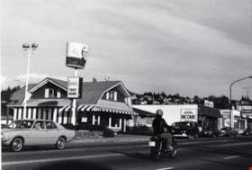
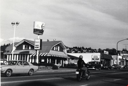
Ernie's Take Home
https://search.heritageburnaby.ca/link/archivedescription79330
- Repository
- City of Burnaby Archives
- Date
- November 1, 1976
- Collection/Fonds
- Burnaby Public Library Contemporary Visual Archive Project
- Description Level
- Item
- Physical Description
- 1 photograph : b&w ; 11 x 16 cm mounted on cardboard
- Scope and Content
- Photograph shows Ernie's Take Home at 4605 Hastings Street with its large sign advertising Kentucky Fried Chicken in a bucket. Other businesses to the east are visible as well.
- Repository
- City of Burnaby Archives
- Date
- November 1, 1976
- Collection/Fonds
- Burnaby Public Library Contemporary Visual Archive Project
- Physical Description
- 1 photograph : b&w ; 11 x 16 cm mounted on cardboard
- Description Level
- Item
- Record No.
- 556-245
- Access Restriction
- No restrictions
- Reproduction Restriction
- Reproduce for fair dealing purposes only
- Accession Number
- 2013-13
- Scope and Content
- Photograph shows Ernie's Take Home at 4605 Hastings Street with its large sign advertising Kentucky Fried Chicken in a bucket. Other businesses to the east are visible as well.
- Subjects
- Buildings - Commercial - Restaurants
- Names
- Ernie's Take Home
- Media Type
- Photograph
- Notes
- Scope note taken directly from BPL photograph description.
- 1 b&w copy negative : 10 x 12.5 cm accompanying
- Photographers identified by surnames only: Carr and Vardeman
- Geographic Access
- Hastings Street
- Street Address
- 4605 Hastings Street
- Historic Neighbourhood
- Capitol Hill (Historic Neighbourhood)
- Planning Study Area
- Capitol Hill Area
Images

Garage Sale Sign
https://search.heritageburnaby.ca/link/archivedescription79926
- Repository
- City of Burnaby Archives
- Date
- September 7, 1976
- Collection/Fonds
- Burnaby Public Library Contemporary Visual Archive Project
- Description Level
- Item
- Physical Description
- 1 photograph : b&w ; 11 x 16 cm mounted on cardboard
- Scope and Content
- Photograph shows signs advertising a garage sale at 6889 Adair Street. The owners held the sale prior to moving from Burnaby into Vancouver.
- Repository
- City of Burnaby Archives
- Date
- September 7, 1976
- Collection/Fonds
- Burnaby Public Library Contemporary Visual Archive Project
- Physical Description
- 1 photograph : b&w ; 11 x 16 cm mounted on cardboard
- Description Level
- Item
- Record No.
- 556-497
- Access Restriction
- No restrictions
- Reproduction Restriction
- Reproduce for fair dealing purposes only
- Accession Number
- 2013-13
- Scope and Content
- Photograph shows signs advertising a garage sale at 6889 Adair Street. The owners held the sale prior to moving from Burnaby into Vancouver.
- Media Type
- Photograph
- Photographer
- Born, A. J.
- Notes
- Scope note taken directly from BPL photograph description.
- 1 b&w copy negative : 10 x 12.5 cm accompanying
- Geographic Access
- Adair Street
- Street Address
- 6889 Adair Street
- Historic Neighbourhood
- Lochdale (Historic Neighbourhood)
- Planning Study Area
- Sperling-Broadway Area
Images


Hastings Street
https://search.heritageburnaby.ca/link/archivedescription79985
- Repository
- City of Burnaby Archives
- Date
- October, 1976
- Collection/Fonds
- Burnaby Public Library Contemporary Visual Archive Project
- Description Level
- Item
- Physical Description
- 1 photograph : b&w ; 11 x 16 cm mounted on cardboard
- Scope and Content
- Photograph shows shoppers walking down the 4100 Block of Hastings Street. The Helen's "swinging girl" sign can be seen in the background, along with numerous other signs advertising the businesses in the area.
- Repository
- City of Burnaby Archives
- Date
- October, 1976
- Collection/Fonds
- Burnaby Public Library Contemporary Visual Archive Project
- Physical Description
- 1 photograph : b&w ; 11 x 16 cm mounted on cardboard
- Description Level
- Item
- Record No.
- 556-541
- Access Restriction
- No restrictions
- Reproduction Restriction
- Reproduce for fair dealing purposes only
- Accession Number
- 2013-13
- Scope and Content
- Photograph shows shoppers walking down the 4100 Block of Hastings Street. The Helen's "swinging girl" sign can be seen in the background, along with numerous other signs advertising the businesses in the area.
- Names
- Helen's Childrens Wear
- Media Type
- Photograph
- Photographer
- Cook, Alan
- Notes
- Scope note taken directly from BPL photograph description.
- 1 b&w copy negative : 10 x 12.5 cm accompanying
- Geographic Access
- Hastings Street
- Historic Neighbourhood
- Vancouver Heights (Historic Neighbourhood)
- Planning Study Area
- Willingdon Heights Area
Images

![Heritage Christmas Decorations at Burnaby Village Museum, [between 1990-1992] thumbnail](/media/hpo/_Data/_BVM_Images/2019/2019_0024_0001_001.jpg?width=280)
Heritage Christmas Decorations at Burnaby Village Museum
https://search.heritageburnaby.ca/link/museumdescription10267
- Repository
- Burnaby Village Museum
- Date
- [between 1990-1992]
- Collection/Fonds
- Burnaby Village Museum Photograph collection
- Description Level
- Item
- Physical Description
- 1 photograph; col. Digital
- Scope and Content
- Taken during the Burnaby Village Museum's Heritage Christmas event. People are seen watching a blacksmith demonstration near a sign advertising triple spring bumpers.
- Repository
- Burnaby Village Museum
- Collection/Fonds
- Burnaby Village Museum Photograph collection
- Description Level
- Item
- Physical Description
- 1 photograph; col. Digital
- Scope and Content
- Taken during the Burnaby Village Museum's Heritage Christmas event. People are seen watching a blacksmith demonstration near a sign advertising triple spring bumpers.
- Names
- Burnaby Village Museum
- Accession Code
- BV019.24.1
- Access Restriction
- No restrictions
- Reproduction Restriction
- No known restrictions
- Date
- [between 1990-1992]
- Media Type
- Photograph
- Scan Resolution
- 600
- Scan Date
- 11-Mar-2019
- Scale
- 96
- Photographer
- Lucy, Patrick
- Notes
- Title based on contents of photograph.
Images
![Heritage Christmas Decorations at Burnaby Village Museum, [between 1990-1992] thumbnail](/media/hpo/_Data/_BVM_Images/2019/2019_0024_0001_001.jpg)
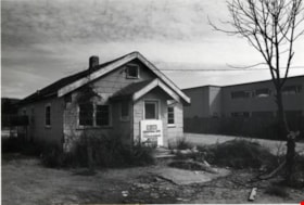
House on Norland Avenue
https://search.heritageburnaby.ca/link/archivedescription79438
- Repository
- City of Burnaby Archives
- Date
- October, 1976
- Collection/Fonds
- Burnaby Public Library Contemporary Visual Archive Project
- Description Level
- Item
- Physical Description
- 1 photograph : b&w ; 11 x 16 cm mounted on cardboard
- Scope and Content
- Photograph shows a vacant house at 2874 Norland Avenue with a sign advertising the property as an industrial site.
- Repository
- City of Burnaby Archives
- Date
- October, 1976
- Collection/Fonds
- Burnaby Public Library Contemporary Visual Archive Project
- Physical Description
- 1 photograph : b&w ; 11 x 16 cm mounted on cardboard
- Description Level
- Item
- Record No.
- 556-290
- Access Restriction
- No restrictions
- Reproduction Restriction
- Reproduce for fair dealing purposes only
- Accession Number
- 2013-13
- Scope and Content
- Photograph shows a vacant house at 2874 Norland Avenue with a sign advertising the property as an industrial site.
- Media Type
- Photograph
- Photographer
- Cook, Alan
- Notes
- Scope note taken directly from BPL photograph description.
- 1 b&w copy negative : 10 x 12.5 cm accompanying
- Geographic Access
- Norland Avenue
- Street Address
- 2874 Norland Avenue
- Historic Neighbourhood
- Burnaby Lake (Historic Neighbourhood)
- Planning Study Area
- Ardingley-Sprott Area
Images


Kingcrest Animal Hospital
https://search.heritageburnaby.ca/link/archivedescription93693
- Repository
- City of Burnaby Archives
- Date
- June 4, 1978
- Collection/Fonds
- Burnaby Public Library Contemporary Visual Archive Project
- Description Level
- Item
- Physical Description
- 1 photograph : b&w ; 12.5 x 17.5 cm
- Scope and Content
- Photograph of the parking lot and exterior of a single-storey building with a sign advertising the Kingcrest Animal Hospital, located at Kingsway and Sperling. The photograph is taken from across the street, facing south.
- Repository
- City of Burnaby Archives
- Date
- June 4, 1978
- Collection/Fonds
- Burnaby Public Library Contemporary Visual Archive Project
- Physical Description
- 1 photograph : b&w ; 12.5 x 17.5 cm
- Description Level
- Item
- Record No.
- 556-650
- Access Restriction
- No restrictions
- Reproduction Restriction
- Reproduce for fair dealing purposes only
- Accession Number
- 2017-57
- Scope and Content
- Photograph of the parking lot and exterior of a single-storey building with a sign advertising the Kingcrest Animal Hospital, located at Kingsway and Sperling. The photograph is taken from across the street, facing south.
- Subjects
- Buildings - Commercial
- Media Type
- Photograph
- Photographer
- Chapman, Fred
- Notes
- Title taken from project information form
- Accompanied by a project information form and 1 photograph (b&w negative ; 9.5 x 12.5 cm)
- BPL no. 98
- Geographic Access
- Kingsway
- Sperling Avenue
- Historic Neighbourhood
- Edmonds (Historic Neighbourhood)
- Planning Study Area
- Windsor Area
Images


Matheson and Sons Market
https://search.heritageburnaby.ca/link/archivedescription35041
- Repository
- City of Burnaby Archives
- Date
- 1949 (date of original), copied 1986
- Collection/Fonds
- Burnaby Historical Society fonds
- Description Level
- Item
- Physical Description
- 1 photograph : col. ; 8.6 x 12.7 cm print
- Scope and Content
- Photograph of the exterior of A. Matheson and Sons Market at 3576 Kingsway (later renumbered 4920 Kingsway) and Nelson Avenue. Signs on the building read, "A. Matheson & Sons Market," "Fresh Meats - Groceries," "Quality and Service," "Dexter 1372 1373," and "Free Delivery." Signs advertising pric…
- Repository
- City of Burnaby Archives
- Date
- 1949 (date of original), copied 1986
- Collection/Fonds
- Burnaby Historical Society fonds
- Subseries
- Chamberlain family subseries
- Physical Description
- 1 photograph : col. ; 8.6 x 12.7 cm print
- Description Level
- Item
- Record No.
- 179-012
- Access Restriction
- No restrictions
- Reproduction Restriction
- Reproduce for fair dealing purposes only
- Accession Number
- BHS1986-27
- Scope and Content
- Photograph of the exterior of A. Matheson and Sons Market at 3576 Kingsway (later renumbered 4920 Kingsway) and Nelson Avenue. Signs on the building read, "A. Matheson & Sons Market," "Fresh Meats - Groceries," "Quality and Service," "Dexter 1372 1373," and "Free Delivery." Signs advertising prices are outside the store. A sign by the street lights reads, "Signals set for 29 mph." Cars can be seen. This store was previously owned and operated by Alexander MacKenzie.
- Media Type
- Photograph
- Notes
- Title based on contents of photograph
- Print made from col. slide
- Geographic Access
- Kingsway
- Street Address
- 4920 Kingsway
- Historic Neighbourhood
- Central Park (Historic Neighbourhood)
- Planning Study Area
- Marlborough Area
Images


Matheson and Sons Market
https://search.heritageburnaby.ca/link/archivedescription35042
- Repository
- City of Burnaby Archives
- Date
- 1949 (date of original), copied 1986
- Collection/Fonds
- Burnaby Historical Society fonds
- Description Level
- Item
- Physical Description
- 1 photograph : col. ; 8.8 x 12.6 cm print
- Scope and Content
- Photograph of the exterior of A. Matheson and Sons Market at 3576 Kingsway (later renumbered 4920 Kingsway) and Nelson Avenue. Signs on the building read, "A. Matheson & Sons Market," "Fresh Meats - Groceries," "Quality and Service," "Dexter 1372 1373," and "Free Delivery." Signs advertising pric…
- Repository
- City of Burnaby Archives
- Date
- 1949 (date of original), copied 1986
- Collection/Fonds
- Burnaby Historical Society fonds
- Subseries
- Chamberlain family subseries
- Physical Description
- 1 photograph : col. ; 8.8 x 12.6 cm print
- Description Level
- Item
- Record No.
- 179-013
- Access Restriction
- No restrictions
- Reproduction Restriction
- Reproduce for fair dealing purposes only
- Accession Number
- BHS1986-27
- Scope and Content
- Photograph of the exterior of A. Matheson and Sons Market at 3576 Kingsway (later renumbered 4920 Kingsway) and Nelson Avenue. Signs on the building read, "A. Matheson & Sons Market," "Fresh Meats - Groceries," "Quality and Service," "Dexter 1372 1373," and "Free Delivery." Signs advertising prices are outside the store. A sign by the street lights reads, "Signals set for 29 mph." This store was previously owned and operated by Alexander MacKenzie.
- Media Type
- Photograph
- Notes
- Title based on contents of photograph
- Print made from col. slide
- Geographic Access
- Kingsway
- Street Address
- 4920 Kingsway
- Historic Neighbourhood
- Central Park (Historic Neighbourhood)
- Planning Study Area
- Marlborough Area
Images

![Metrotown Eaton's store closing, [1999] thumbnail](/media/hpo/_Data/_Archives_Images/_Unrestricted/535/535-3307-1.jpg?width=280)
Metrotown Eaton's store closing
https://search.heritageburnaby.ca/link/archivedescription98229
- Repository
- City of Burnaby Archives
- Date
- [1999]
- Collection/Fonds
- Burnaby NewsLeader photograph collection
- Description Level
- File
- Physical Description
- 3 photographs (tiff) : col.
- Scope and Content
- File contains photographs of the Eaton's in the former Eaton Centre, now Metropolis at Metrotown, preparing to close. Photographs depict unidentified shoppers in the store with signs advertising the store closing and sale prices, and an unidentified person posing in the mall in front of a sign of t…
- Repository
- City of Burnaby Archives
- Date
- [1999]
- Collection/Fonds
- Burnaby NewsLeader photograph collection
- Physical Description
- 3 photographs (tiff) : col.
- Description Level
- File
- Record No.
- 535-3307
- Access Restriction
- No restrictions
- Reproduction Restriction
- No restrictions
- Accession Number
- 2018-12
- Scope and Content
- File contains photographs of the Eaton's in the former Eaton Centre, now Metropolis at Metrotown, preparing to close. Photographs depict unidentified shoppers in the store with signs advertising the store closing and sale prices, and an unidentified person posing in the mall in front of a sign of the Eaton's logo.
- Names
- Metrotown
- Media Type
- Photograph
- Notes
- Title based on contents of file
- Collected by editorial for use in an August 1999 issue of the Burnaby NewsLeader
- Geographic Access
- Kingsway
- Street Address
- 4700 Kingsway
- Historic Neighbourhood
- Central Park (Historic Neighbourhood)
- Planning Study Area
- Maywood Area
Images
![Metrotown Eaton's store closing, [1999] thumbnail](/media/hpo/_Data/_Archives_Images/_Unrestricted/535/535-3307-1.jpg)
![Model Grocery, [1914] (date of original), copied [1973] thumbnail](/media/hpo/_Data/_BVM_Images/1973/1973_0098_0001_001.jpg?width=280)
Model Grocery
https://search.heritageburnaby.ca/link/museumdescription3069
- Repository
- Burnaby Village Museum
- Date
- [1914] (date of original), copied [1973]
- Collection/Fonds
- Burnaby Village Museum Photograph collection
- Description Level
- Item
- Physical Description
- 1 photograph : b&w ; 20.1 x 25.1 cm print
- Scope and Content
- Photograph of Bill Hay (on left) and James Scott standing at the front entrance to the Model Grocery Store, situated at 2nd Street and 15th Avenue in Burnaby. The store has wooden shiplap siding all around and a peaked roof with a tall false front with a wide cornice at the top. The righthand side …
- Repository
- Burnaby Village Museum
- Collection/Fonds
- Burnaby Village Museum Photograph collection
- Description Level
- Item
- Physical Description
- 1 photograph : b&w ; 20.1 x 25.1 cm print
- Scope and Content
- Photograph of Bill Hay (on left) and James Scott standing at the front entrance to the Model Grocery Store, situated at 2nd Street and 15th Avenue in Burnaby. The store has wooden shiplap siding all around and a peaked roof with a tall false front with a wide cornice at the top. The righthand side of the eaves show, and the details of the gutter and downspout are clearly visible. The bottom front of the building is all one store. Display windows fill the front in three sections. On the extreme left and right are two wide windows. In the centre is another narrower window. Between these windows are two doors, set in about five feet. A canvas awning (furled) spans the store over the windows. Inside the windows, displays are visible. In the right hand window are stacks of tinned goods. In the centre, flats of fruit set up to face outwards. In the left window is a large display of White Swan soap. Below the right and left windows are small enamelled signs advertising Fleischman's Yeast. No other sign or advertising is visible on the exterior. In the right hand doorway is a display of washboard and corn brooms. A canvas covered horse drawn delivery wagon with a "308 6th St. Model Grocery" sign is positioned to the right rear of the store.
- Geographic Access
- 2nd Street
- 15th Avenue
- Accession Code
- HV973.98.1
- Access Restriction
- No restrictions
- Reproduction Restriction
- May be restricted by third party rights
- Date
- [1914] (date of original), copied [1973]
- Media Type
- Photograph
- Historic Neighbourhood
- East Burnaby (Historic Neighbourhood)
- Planning Study Area
- Second Street Area
- Related Material
- According to catalogue record from 1976, a taped interview with James Scott and Write up about the store are available in the BVM files.
- Scan Resolution
- 600
- Scan Date
- 2023-05-16
- Notes
- Title based on contents of photograph
- See HV973.98.2 for original negative associated with this copy print
- Related materials: According to a note with the photograph, a taped interview with James Scott (1975) and a write-up about this store are in the Burnaby Village Museum archives
Images
![Model Grocery, [1914] (date of original), copied [1973] thumbnail](/media/hpo/_Data/_BVM_Images/1973/1973_0098_0001_001.jpg)
![Opening of the Knight and Day Restaurant at Boundary and Lougheed Highway, [1982] thumbnail](/media/Hpo/_Data/_Archives_Images/_Unrestricted/480/480-1530.jpg?width=280)
Opening of the Knight and Day Restaurant at Boundary and Lougheed Highway
https://search.heritageburnaby.ca/link/archivedescription59215
- Repository
- City of Burnaby Archives
- Date
- [1982]
- Collection/Fonds
- Columbian Newspaper collection
- Description Level
- Item
- Physical Description
- 1 photograph : b&w ; 8.5 x 18.5 cm
- Scope and Content
- Photograph of a sign advertising the new location of Knight & Day Restaurant opening in December. There is a long line of people lining up next to the restaurant in the background.
- Repository
- City of Burnaby Archives
- Date
- [1982]
- Collection/Fonds
- Columbian Newspaper collection
- Physical Description
- 1 photograph : b&w ; 8.5 x 18.5 cm
- Description Level
- Item
- Record No.
- 480-1530
- Access Restriction
- No restrictions
- Reproduction Restriction
- No restrictions
- Accession Number
- 2009-01
- Scope and Content
- Photograph of a sign advertising the new location of Knight & Day Restaurant opening in December. There is a long line of people lining up next to the restaurant in the background.
- Media Type
- Photograph
- Photographer
- King, Basil
- Notes
- Title based on contents of photograph
- Photographer's stamp on verso
- Note on verso reads: "PMT 100% / page 1 / Burnaby Today"
- Geographic Access
- Lougheed Highway
- Boundary Road
Images
![Opening of the Knight and Day Restaurant at Boundary and Lougheed Highway, [1982] thumbnail](/media/Hpo/_Data/_Archives_Images/_Unrestricted/480/480-1530.jpg)

Palm Springs Health Spa
https://search.heritageburnaby.ca/link/archivedescription79241
- Repository
- City of Burnaby Archives
- Date
- October, 1976
- Collection/Fonds
- Burnaby Public Library Contemporary Visual Archive Project
- Description Level
- Item
- Physical Description
- 1 photograph : b&w ; 11 x 16 cm mounted on cardboard
- Scope and Content
- Photograph shows a close up of the ornamental sign advertising the Palm Springs Health Spa, reading "2 memberships for the price of 1."
- Repository
- City of Burnaby Archives
- Date
- October, 1976
- Collection/Fonds
- Burnaby Public Library Contemporary Visual Archive Project
- Physical Description
- 1 photograph : b&w ; 11 x 16 cm mounted on cardboard
- Description Level
- Item
- Record No.
- 556-219
- Access Restriction
- No restrictions
- Reproduction Restriction
- Reproduce for fair dealing purposes only
- Accession Number
- 2013-13
- Scope and Content
- Photograph shows a close up of the ornamental sign advertising the Palm Springs Health Spa, reading "2 memberships for the price of 1."
- Names
- Palm Springs Health Spa
- Media Type
- Photograph
- Photographer
- McCarron, John
- Notes
- Scope note taken directly from BPL photograph description.
- 1 b&w copy negative : 10 x 12.5 cm accompanying
- Geographic Access
- Kingsway
- Street Address
- 5500 Kingsway
- Historic Neighbourhood
- Central Park (Historic Neighbourhood)
- Planning Study Area
- Windsor Area
Images
