Narrow Results By
Decade
- 2020s 90
- 2010s 220
- 2000s
- 1990s 541
- 1980s 578
- 1970s 1265
- 1960s 593
- 1950s 464
- 1940s
- 1930s 355
- 1920s 539
- 1910s 357
- 1900s 136
- 1890s 71
- 1880s 26
- 1870s 9
- 1860s 20
- 1850s 8
- 1840s 4
- 1830s 2
- 1820s 2
- 1810s 3
- 1800s 3
- 1790s 3
- 1780s 3
- 1770s 3
- 1760s 3
- 1750s 3
- 1740s 3
- 1730s 3
- 1720s 3
- 1710s 3
- 1700s 3
- 1690s 3
- 1680s 3
- 1670s 2
- 1660s 2
- 1650s 2
- 1640s 2
- 1630s 2
- 1620s 2
- 1610s 2
- 1600s 2
- 1590s 1
- 1580s 1
- 1570s 1
- 1560s 1
- 1550s 1
- 1540s 1
- 1530s 1
- 1520s 2
- 1510s 1
- 1500s 1
- 1490s 1
- 1480s 1
Road Closure Reference #00-4 X-Ref: PPA #00-269 & Sub. #01-17 Closure of a ptn. Of the unopened 11th Avenue Road Allowance at Canada Way and dedication for the widening of Canada Way
https://search.heritageburnaby.ca/link/councilreport3757
- Repository
- City of Burnaby Archives
- Report ID
- 63387
- Meeting Date
- 9-Apr-2001
- Format
- Council - Manager's Report
- Manager's Report No.
- 11
- Item No.
- 5
- Collection/Fonds
- City Council and Office of the City Clerk fonds
- Repository
- City of Burnaby Archives
- Report ID
- 63387
- Meeting Date
- 9-Apr-2001
- Format
- Council - Manager's Report
- Manager's Report No.
- 11
- Item No.
- 5
- Collection/Fonds
- City Council and Office of the City Clerk fonds
Documents
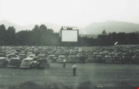
Cascades Drive-In Theatre
https://search.heritageburnaby.ca/link/landmark689
- Repository
- Burnaby Heritage Planning
- Geographic Access
- Grandview Highway
- Associated Dates
- 1946
- Heritage Value
- The Cascades Drive-In Theatre was Canada's first drive-in and was started by George and William Steel and Joe and Art Johnson in 1946. Built along Grandview Highway (Canada Way) near Smith Street, the theatre opened on August 30, 1946. In 1977, the theatre was purchased by Don Soutar, Al Chappell and Norm Green and continued to operate until 1980. The property was then redeveloped as Cascades Village - a large condominium complex.
- Historic Neighbourhood
- Broadview (Historic Neighbourhood)
- Planning Study Area
- Cascade-Schou Area
- Street Address
- 4050 Grandview Highway
Images
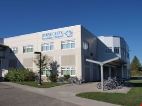
Byrne Creek Secondary School
https://search.heritageburnaby.ca/link/landmark849
- Repository
- Burnaby Heritage Planning
- Geographic Access
- 18th Street
- Associated Dates
- 2005
- Heritage Value
- Byrne Creek School opened in 2005 and accommodates students from grades 8 through 12. When built, the school was created to house as many as 1200 students, but by 2009, plans have been prepared to increase that capacity to 1500.
- Historic Neighbourhood
- Edmonds (Historic Neighbourhood)
- Planning Study Area
- Stride Avenue Area
- Street Address
- 7777 18th Street
- Street View URL
- Google Maps Street View
Images
Douglas-Gilpin Neighbourhood
https://search.heritageburnaby.ca/link/landmark799
- Repository
- Burnaby Heritage Planning
- Associated Dates
- 1955-2008
- Heritage Value
- The Douglas-Gilpin Neighbourhood developed into a diverse area incorporating residential, business, educational and park districts in the period after 1955. The BCIT site was built in the early 1960s, shortly after the Burnaby Municipal Hall was located on Canada Way near Deer Lake in 1956. The construction of the Municipal Hall at this location fostered the creation of an administrative and business centre adjacent to the park, while the northern and central areas of the neighbourhood retained their primarily residential character.
- Historic Neighbourhood
- Burnaby Lake (Historic Neighbourhood)
- Planning Study Area
- Douglas-Gilpin Area
Images
Lake City Neighbourhood
https://search.heritageburnaby.ca/link/landmark793
- Repository
- Burnaby Heritage Planning
- Associated Dates
- 1955-2008
- Heritage Value
- When Simon Fraser University opened in 1965, approximately sixteen industrial properties had been developed in the Lake City Industrial Park. In addition, significant tracts of land in the western portion had been pre-cleared and graded in anticipation of additional development, while most of the eastern half remained forested. Some of the early companies to locate in the area were Nabob Foods, Volkswagen Canada, British Columbia Television Broadcasting, Simpson Sears, and H.Y. Louie Company Limited. Both Imperial Oil and Shell Oil established petroleum storage and distribution facilities in the area. Initially a heavy industrial area, by 1979, single family neighbourhoods south of Lougheed Highway and west of Eagle Creek had been largely developed. By the mid1980's, the Burnaby 200 multi-family development along Forest Grove Drive had also been completed.
- Planning Study Area
- Lake City Area
Images
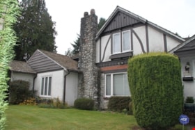
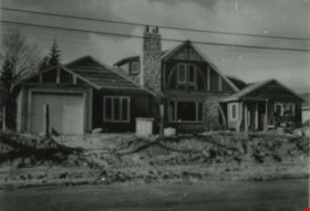
Montague & Marcia Moore Residence
https://search.heritageburnaby.ca/link/landmark499
- Repository
- Burnaby Heritage Planning
- Description
- The Montague and Marcia Moore Residence, situated on Sperling Avenue, is a one and one-half storey wood-frame house with Tudor Revival elements such as half-timbering and diamond-leaded windows. The landscaping includes a large hedge at the front of the property. It is located on a lakefront site w…
- Associated Dates
- 1943
- Street View URL
- Google Maps Street View
- Repository
- Burnaby Heritage Planning
- Geographic Access
- Sperling Avenue
- Associated Dates
- 1943
- Description
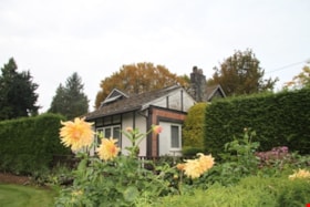
- The Montague and Marcia Moore Residence, situated on Sperling Avenue, is a one and one-half storey wood-frame house with Tudor Revival elements such as half-timbering and diamond-leaded windows. The landscaping includes a large hedge at the front of the property. It is located on a lakefront site within the scenic Deer Lake Park Heritage Precinct.
- Heritage Value
- Located within the historic Deer Lake Park neighbourhood, the Montague and Marcia Moore Residence is valued as an example of the late persistence of the historicist influence on domestic architecture, at a time when it was still considered the height of good taste for a house to be designed in a recognizable period revival style. This is reflected in the rustic Tudor Revival elements such as half-timbering, waney-edged boards in the gables, brick nogging, diamond-leaded windows, and bird houses in the main gable. The cobblestone chimney, the major focal point of the house, was constructed from river stones that were transported from Lynn Canyon. Meticulously retained in its original condition, this was the last home to be constructed by the Moore family before the Second World War construction supply rationing took effect. It was built by Danish contractor, Hans Jorgensen Hau (1878-1944), who had a flair for the construction of homes with a rustic character, and shares a number of design features with Hau’s own house at 5070 Canada Way.
- Defining Elements
- Key elements that define the heritage character of the Montague and Marcia Moore Residence include its: - location on a lakefront site, within the Deer Lake Park Heritage Precinct - residential form, scale and massing as expressed by its one and one-half storey height, rectangular plan and front gabled roof - wood-frame construction - Tudor Revival elements such as stucco and wood half-timbering, diamond-leaded casement windows, scroll-cut brackets, brick nogging on the front façade, bird houses in the main front gable, waney-edged boards at gable peaks, plank front door with strap hinges and a prominent external cobblestone chimney - associated landscape features such as a granite wall, and mature coniferous and deciduous trees
- Historic Neighbourhood
- Burnaby Lake (Historic Neighbourhood)
- Planning Study Area
- Morley-Buckingham Area
- Organization
- Canadian Institute of Mining and Metallurgy
- Builder
- Hans Jorgensen Hau
- Function
- Primary Historic--Single Dwelling
- Primary Current--Single Dwelling
- Community
- Deer Lake
- Cadastral Identifier
- P.I.D.006-082-696
- Boundaries
- The Montague and Marcia Moore Residence is comprised of a single residential lot located at 5165 Sperling Avenue, Burnaby.
- Area
- 4104
- Contributing Resource
- Building
- Ownership
- Public (local)
- Documentation
- City of Burnaby Planning and Building Department, Heritage Site Files
- Street Address
- 5165 Sperling Avenue
- Street View URL
- Google Maps Street View
Images
Moore House
https://search.heritageburnaby.ca/link/landmark497
- Repository
- Burnaby Heritage Planning
- Description
- The Moore House is a one-storey, side-gabled house with stepped roof planes and a split-level attached garage. The house faces east, and features distinct river rock porch columns and a large central tapered chimney. It is located within the Deer Lake Park Heritage Precinct, and is adjacent to a re…
- Associated Dates
- 1941
- Formal Recognition
- Community Heritage Register
- Other Names
- Ethel Moore Residence
- Street View URL
- Google Maps Street View
- Repository
- Burnaby Heritage Planning
- Other Names
- Ethel Moore Residence
- Geographic Access
- Sperling Avenue
- Associated Dates
- 1941
- Formal Recognition
- Community Heritage Register
- Enactment Type
- Council Resolution
- Enactment Date
- 26/05/2003
- Description
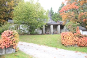
- The Moore House is a one-storey, side-gabled house with stepped roof planes and a split-level attached garage. The house faces east, and features distinct river rock porch columns and a large central tapered chimney. It is located within the Deer Lake Park Heritage Precinct, and is adjacent to a related house, the Rosalie (Moore) Barrett Residence, built the following year.
- Heritage Value
- The Moore House is significant for its relationship to first owner, Ethel Hutchings Moore (1884-1948), who purchased the property from Maud and Harriet Woodward, two of Deer Lake's first residents. Moore purchased the property with the hopes of introducing her children into the house construction business. This house, built in 1941, borrows its design from a 'California Desert House' built in Carmel a few years earlier. Rendered in traditional materials, this modern style merges comfortably with the rustic British Arts and Crafts tradition of most Deer Lake houses. Unusual for being built during wartime date, it was built at a time when domestic construction was severely curtailed due to shortages of labour and material. It is now owned by the City of Burnaby and is part of the Deer Lake Park Heritage Precinct. The Moore House is significant as a testament to Deer Lake's continued popularity as a residential neighbourhood in the 1940s. Although Burnaby was serviced by a number of transportation links at the time, the increasing availability of automobiles provided improved access to outlying suburbs. Rising real estate prices in Vancouver and New Westminster attracted residents to this neighbourhood because of its relative affordability, central location and beautiful scenery.
- Defining Elements
- Key elements that define the heritage character of the Moore House include its: - location within the Deer Lake Park Heritage Precinct - residential form, scale and massing as expressed by its one-storey height, linear plan, side gabled roof with multiple roof planes and split-level attached garage - wood-frame construction with stucco cladding - river rock porch columns and external tapered chimney - decorative embellishments including scroll-cut stickwork on the rear elevation and waney-edged boards in the gable peaks - wooden-sash casement windows with three-part, horizontal leading - associated landscaping features, including stone wall at the front of the property and coniferous and deciduous trees surrounding the property
- Historic Neighbourhood
- Burnaby Lake (Historic Neighbourhood)
- Planning Study Area
- Morley-Buckingham Area
- Function
- Primary Historic--Single Dwelling
- Primary Current--Single Dwelling
- Community
- Deer Lake
- Cadastral Identifier
- P.I.D. 011-454-521
- Boundaries
- The Moore House is comprised of a single residential lot located at 5145 Sperling Avenue, Burnaby.
- Area
- 993.39
- Contributing Resource
- Building
- Ownership
- Public (local)
- Documentation
- City of Burnaby Planning and Building Department, Heritage Site Files
- Street Address
- 5145 Sperling Avenue
- Street View URL
- Google Maps Street View
Images
Morley-Buckingham Neighbourhood
https://search.heritageburnaby.ca/link/landmark829
- Repository
- Burnaby Heritage Planning
- Associated Dates
- 1955-2008
- Heritage Value
- In the 1980 "Residential Neighbourhood Environment Study," the Morley-Buckingham Neighbourhood is described as "perhaps Burnaby's most prestigious residential area. The lots are larger than most other areas of the Municipality and this, along with the new expensive housing developed over the past 10 years, has created a very desirable residential neighbourhood...The older area of Buckingham lies at the lower edge of the slope and here the homes and streets are more uniform and aged between 20 and 25 years old...to the east of Canada Way lies...a cluster townhouse development."
- Historic Neighbourhood
- Burnaby Lake (Historic Neighbourhood)
- Planning Study Area
- Morley-Buckingham Area
Images
Willingdon Heights Neighbourhood
https://search.heritageburnaby.ca/link/landmark670
- Repository
- Burnaby Heritage Planning
- Associated Dates
- 1925-1954
- Heritage Value
- Willingdon Heights was another new subdivision developed in Burnaby during the post-World War Two building boom. A brochure about the development published in 1948 proclaimed "the Willingdon Heights 500 home development project in Burnaby fulfills its promise to provide a self-contained community for former members of the armed services and their families...the largest single veteran housing project in Canada as far as homes for individual ownership is concerned, Willingdon Heights development was planned by the Central Mortgage and Housing Corporation...At this date the earlier built rows of homes have passable roads and the owners are improving lawns and gardens in spare time...eventually additional stores and professional services will be installed and recreational projects will add to the amenities of a community of congenial residents..."
- Planning Study Area
- Willingdon Heights Area
Images
Willingdon Heights Neighbourhood
https://search.heritageburnaby.ca/link/landmark777
- Repository
- Burnaby Heritage Planning
- Associated Dates
- 1955-2008
- Heritage Value
- The convenient location of Willingdon Heights to the Trans Canada Highway, Lougheed Highway and Hastings Street has fostered its development as a primarily residential commuter neighbourhood. Characterised in the post-World War Two period by predominantly single-family developments, the neighbourhood has retained this identity despite some higher density apartment buildings now found there.
- Planning Study Area
- Willingdon Heights Area
Images
BHS Photo Discs by Sid Cumbers 2004
https://search.heritageburnaby.ca/link/archivedescription98460
- Repository
- City of Burnaby Archives
- Date
- 2000-2004
- Collection/Fonds
- Burnaby Historical Society fonds
- Description Level
- File
- Physical Description
- 205 photographs (jpgs and pdd) on 2 optical discs
- Scope and Content
- Photographs of various events in which the Burnaby Historical Society participated including bus trips, Christmas parties, 1223 interurban tram events, and Canada Day and other holiday celebrations.
- Repository
- City of Burnaby Archives
- Date
- 2000-2004
- Collection/Fonds
- Burnaby Historical Society fonds
- Series
- Administration series
- Physical Description
- 205 photographs (jpgs and pdd) on 2 optical discs
- Description Level
- File
- Record No.
- 633-015
- Access Restriction
- No restrictions
- Reproduction Restriction
- No restrictions
- Accession Number
- 2020-06
- Scope and Content
- Photographs of various events in which the Burnaby Historical Society participated including bus trips, Christmas parties, 1223 interurban tram events, and Canada Day and other holiday celebrations.
- Media Type
- Photograph
- Photographer
- Cumbers, Sidney
- Notes
- Transcribed title
- Title transcribed from original disc envelope
- Disc 2020-06-001 label reads: "Burnaby Historical Society 2004 / Content Description 1. BHS Bus Trip, 2000 2. BHS Xmas, 2001 3. BHS XMas, 2003 4. Canada Day, 2004 5. Victoria Day, 2004 6. Tram1223, 2001-2004 7. Tram1223BBQ, 2004 8. Tram1223 Volunteers, 2004:
- Disc 2020-06-002 label reads: "Burnaby Village Museum Labour Day Fair / Monday September 6, 2004"
- Contact sheet for photographs on 2020-06-001 available in accession file.
Images
Canada Day at Burnaby Village Museum
https://search.heritageburnaby.ca/link/archivedescription95783
- Repository
- City of Burnaby Archives
- Date
- [2000]
- Collection/Fonds
- Burnaby NewsLeader photograph collection
- Description Level
- File
- Physical Description
- 3 photographs (tiff) : col.
- Scope and Content
- File contains portrait photographs of three attendees of Canada Day celebrations at Burnaby Village Museum. The people wear Canada flags in their hair and one carries a large Canada flag print umbrella.
- Repository
- City of Burnaby Archives
- Date
- [2000]
- Collection/Fonds
- Burnaby NewsLeader photograph collection
- Physical Description
- 3 photographs (tiff) : col.
- Description Level
- File
- Record No.
- 535-1615
- Access Restriction
- No restrictions
- Reproduction Restriction
- No restrictions
- Accession Number
- 2018-12
- Scope and Content
- File contains portrait photographs of three attendees of Canada Day celebrations at Burnaby Village Museum. The people wear Canada flags in their hair and one carries a large Canada flag print umbrella.
- Subjects
- Events - Festivals
- Holidays - Canada Day
- Names
- Burnaby Village Museum
- Media Type
- Photograph
- Photographer
- Bartel, Mario
- Notes
- Title based on caption
- Collected by editorial for use in a July 2000 issue of the Burnaby NewsLeader
- Caption from metadata for 535-1615-1: "Ana Spence takes shelter under her patriotic umbrella, during one of the occasional showers during Canada Day festivities at Burnaby Village Museum."
- Caption from metadata for 535-1615-2: "Rebecca Hsu wears her Canadian pride on her head, during Canada Day festivities at Burnaby Village Museum."
- Caption from metadata for 535-1615-3: "Laurel Moffat, 8, enjoys a cool treat during Canada Day festivities at Burnaby Village Museum."
- Geographic Access
- Deer Lake Avenue
- Street Address
- 6501 Deer Lake Avenue
- Historic Neighbourhood
- Burnaby Lake (Historic Neighbourhood)
- Planning Study Area
- Morley-Buckingham Area
Images
Canada Day at Burnaby Village Museum
https://search.heritageburnaby.ca/link/archivedescription97038
- Repository
- City of Burnaby Archives
- Date
- [2001]
- Collection/Fonds
- Burnaby NewsLeader photograph collection
- Description Level
- File
- Physical Description
- 2 photographs (tiff) : col.
- Scope and Content
- File contains photographs of Canada Day celebrations at Burnaby Village Museum. Photographs depict Joe Pyringer with his son, Josef, on his shoulders during the event and Gwen Rumble and Blanche Gettling preparing to serve cake to the line up of people visible in the background.
- Repository
- City of Burnaby Archives
- Date
- [2001]
- Collection/Fonds
- Burnaby NewsLeader photograph collection
- Physical Description
- 2 photographs (tiff) : col.
- Description Level
- File
- Record No.
- 535-2570
- Access Restriction
- No restrictions
- Reproduction Restriction
- No restrictions
- Accession Number
- 2018-12
- Scope and Content
- File contains photographs of Canada Day celebrations at Burnaby Village Museum. Photographs depict Joe Pyringer with his son, Josef, on his shoulders during the event and Gwen Rumble and Blanche Gettling preparing to serve cake to the line up of people visible in the background.
- Subjects
- Holidays - Canada Day
- Events
- Names
- Burnaby Village Museum
- Media Type
- Photograph
- Photographer
- Bartel, Mario
- Notes
- Title based on caption
- Collected by editorial for use in a July 2001 issue of the Burnaby NewsLeader
- Caption from metadata for 535-2570-1: "Josef Pyringer, 4, celebrates Canada Day from high atop the shoulders of his dad, Joe, at Burnaby Village Museum. More than 8,000 people crowded the Village square to hear speeches, sing O Canada and then lined up for free cake."
- Caption from metadata for 535-2570-2: "As the lineup snakes out through the gates at Burnaby Village Museum, Gwen Rumble and Blanche Gettling prepare to serve pieces of the giant birthday cake at the Museum's Canada Day festivities."
- Geographic Access
- Deer Lake Avenue
- Street Address
- 4900 Deer Lake Avenue
- 6501 Deer Lake Avenue
- Historic Neighbourhood
- Burnaby Lake (Historic Neighbourhood)
- Planning Study Area
- Morley-Buckingham Area
Images
Metrotown Canada Day
https://search.heritageburnaby.ca/link/archivedescription97033
- Repository
- City of Burnaby Archives
- Date
- [2001]
- Collection/Fonds
- Burnaby NewsLeader photograph collection
- Description Level
- Item
- Physical Description
- 1 photograph (tiff) : col.
- Scope and Content
- Photograph of Metrotown employees Kumi Blais, of Utsuwa-no-yakata, and Ross Oliver, of Sears, with party favours and standing in front of the a large Canadian flag hanging over the centre court at Metrotown, ahead of the mall's Canada Day celebrations.
- Repository
- City of Burnaby Archives
- Date
- [2001]
- Collection/Fonds
- Burnaby NewsLeader photograph collection
- Physical Description
- 1 photograph (tiff) : col.
- Description Level
- Item
- Record No.
- 535-2565
- Access Restriction
- No restrictions
- Reproduction Restriction
- No restrictions
- Accession Number
- 2018-12
- Scope and Content
- Photograph of Metrotown employees Kumi Blais, of Utsuwa-no-yakata, and Ross Oliver, of Sears, with party favours and standing in front of the a large Canadian flag hanging over the centre court at Metrotown, ahead of the mall's Canada Day celebrations.
- Names
- Metrotown
- Media Type
- Photograph
- Photographer
- Bartel, Mario
- Notes
- Title based on caption
- Collected by editorial for use in a July 2001 issue of the Burnaby NewsLeader
- Caption from metadata: "Kumi Blais, of Utsuwa-no-yakata, and Ross Oliver, of Sears, get ready to celebrate Canada's birthday below the largest indoor Canadian flag in the country, hanging over center court at Metrotown Centre. The mall will be hosting it's own Canada Day celebrations on Sunday, featuring a 12-foot birthday cake. Another giant cake will be divided up at Burnaby Village Museum, and New Westminster will be hosting its annual Heritage Canada Day festivities at Queen's Park."
- Geographic Access
- Kingsway
- Street Address
- 4700 Kingsway
- Historic Neighbourhood
- Central Park (Historic Neighbourhood)
- Planning Study Area
- Maywood Area
Images
4796 Canada Way - Unsightly and Overgrown Property
https://search.heritageburnaby.ca/link/councilreport52896
- Repository
- City of Burnaby Archives
- Report ID
- 68025
- Meeting Date
- 23-Jun-2008
- Format
- Council - Manager's Report
- Item No.
- 12
- Collection/Fonds
- City Council and Office of the City Clerk fonds
- Repository
- City of Burnaby Archives
- Report ID
- 68025
- Meeting Date
- 23-Jun-2008
- Format
- Council - Manager's Report
- Item No.
- 12
- Collection/Fonds
- City Council and Office of the City Clerk fonds
Documents
Application for Funding Assistance; 2006-2007 BC Hydro Beautification Program; Proposed Priority Project: Canada Way from Kensington Avenue to Deer Lake Avenue
https://search.heritageburnaby.ca/link/councilreport967
- Repository
- City of Burnaby Archives
- Report ID
- 66190
- Meeting Date
- 7-Nov-2005
- Format
- Council - Manager's Report
- Item No.
- 2
- Collection/Fonds
- City Council and Office of the City Clerk fonds
- Repository
- City of Burnaby Archives
- Report ID
- 66190
- Meeting Date
- 7-Nov-2005
- Format
- Council - Manager's Report
- Item No.
- 2
- Collection/Fonds
- City Council and Office of the City Clerk fonds
Documents
Application for Funding Assistance 2009/2010 BC Hydro Beautification Program - Proposed Priority Project for 2009/2010 Canada Way Beautification Project
https://search.heritageburnaby.ca/link/councilreport55899
- Repository
- City of Burnaby Archives
- Report ID
- 72271
- Meeting Date
- 23-Mar-2009
- Format
- Council - Manager's Report
- Item No.
- 4
- Collection/Fonds
- City Council and Office of the City Clerk fonds
- Repository
- City of Burnaby Archives
- Report ID
- 72271
- Meeting Date
- 23-Mar-2009
- Format
- Council - Manager's Report
- Item No.
- 4
- Collection/Fonds
- City Council and Office of the City Clerk fonds
Documents
Application of United Church of Canada for Approval of Construction of a Senior Citizens Housing Project on Block B, DL 149
https://search.heritageburnaby.ca/link/councilreport47811
- Repository
- City of Burnaby Archives
- Report ID
- 47996
- Meeting Date
- 28-Nov-1949
- Format
- Council - Mayor/Councillor/Staff Report
- Collection/Fonds
- City Council and Office of the City Clerk fonds
- Repository
- City of Burnaby Archives
- Report ID
- 47996
- Meeting Date
- 28-Nov-1949
- Format
- Council - Mayor/Councillor/Staff Report
- Collection/Fonds
- City Council and Office of the City Clerk fonds
Documents
Barnet Book Project: Shell Canada Grant
https://search.heritageburnaby.ca/link/councilreport1475
- Repository
- City of Burnaby Archives
- Report ID
- 65666
- Meeting Date
- 6-Dec-2004
- Format
- Council - Committee Report
- Collection/Fonds
- City Council and Office of the City Clerk fonds
- Repository
- City of Burnaby Archives
- Report ID
- 65666
- Meeting Date
- 6-Dec-2004
- Format
- Council - Committee Report
- Collection/Fonds
- City Council and Office of the City Clerk fonds
Documents
BC Electric Company Takeover of Bridge River Power Company, Vancouver Power Company and Western Power Company of Canada
https://search.heritageburnaby.ca/link/councilreport47789
- Repository
- City of Burnaby Archives
- Report ID
- 47987
- Meeting Date
- 28-Nov-1949
- Format
- Council - Mayor/Councillor/Staff Report
- Collection/Fonds
- City Council and Office of the City Clerk fonds
- Repository
- City of Burnaby Archives
- Report ID
- 47987
- Meeting Date
- 28-Nov-1949
- Format
- Council - Mayor/Councillor/Staff Report
- Collection/Fonds
- City Council and Office of the City Clerk fonds




![Canada Day at Burnaby Village Museum, [2000] thumbnail](/media/hpo/_Data/_Archives_Images/_Unrestricted/535/535-1615-3.jpg?width=280)
![Canada Day at Burnaby Village Museum, [2001] thumbnail](/media/hpo/_Data/_Archives_Images/_Unrestricted/535/535-2570-2.jpg?width=280)
![Metrotown Canada Day, [2001] thumbnail](/media/hpo/_Data/_Archives_Images/_Unrestricted/535/535-2565.jpg?width=280)