Narrow Results By
Subject
- Animals 3
- Animals - Birds 16
- Animals - Dogs 1
- Buildings - Civic - Museums 1
- Buildings - Commercial - Malls 1
- Buildings - Industrial 1
- Emergency Services - Ambulance Services 1
- Geographic Features - Forests 6
- Geographic Features - Lakes and Ponds 27
- Geographic Features - Parks 3
- Geographic Features - Rivers 1
- Natural Phenomena 1
![Survey and Subdivision plans in New Westminster District Group 1 – Burnaby, Port Moody, [1862-1908] thumbnail](/media/hpo/_Data/_BVM_Cartographic_Material/1977/1977_0093_0026a_001.jpg?width=280)
Survey and Subdivision plans in New Westminster District Group 1 – Burnaby, Port Moody
https://search.heritageburnaby.ca/link/museumdescription6995
- Repository
- Burnaby Village Museum
- Date
- [1862-1908]
- Collection/Fonds
- Burnaby Village Museum Map collection
- Description Level
- File
- Physical Description
- 9 plans : 6 plans : black ink on paper ; 57 x 36.5 cm or smaller + 1 plan : black ink and grahite on paper ; 46.5 x 49 cm + 1 plan : blueprint on paper ; 15.5 x 19.5 cm + cm + 1 plan : graphite on paper ; 25 x 17 cm ; mounted on both sides of board 76 x 102 cm
- Scope and Content
- Item consists of a large board of four New Westminster District subdivision plans mounted on one side and five New Westminster District subdivision plans mounted on the other side. Side A: 1. "Plan / of Subdivision / of a Portion / of / Lot 87 / Group One / New Westminster District / Scale 4 chs…
- Repository
- Burnaby Village Museum
- Collection/Fonds
- Burnaby Village Museum Map collection
- Description Level
- File
- Physical Description
- 9 plans : 6 plans : black ink on paper ; 57 x 36.5 cm or smaller + 1 plan : black ink and grahite on paper ; 46.5 x 49 cm + 1 plan : blueprint on paper ; 15.5 x 19.5 cm + cm + 1 plan : graphite on paper ; 25 x 17 cm ; mounted on both sides of board 76 x 102 cm
- Material Details
- Scales [between 1:792 and 1:3600]
- Index number on edge of board reads: "26"
- Scope and Content
- Item consists of a large board of four New Westminster District subdivision plans mounted on one side and five New Westminster District subdivision plans mounted on the other side. Side A: 1. "Plan / of Subdivision / of a Portion / of / Lot 87 / Group One / New Westminster District / Scale 4 chs = 1 in". Plan is stamped: "Albert J. Hill, Civil Engineer / and / Provincial Land Surveyor, / New Westminster, / B.C." and intialed by: "RB" [sic] (in blue pencil crayon). Names two of the subdivisons of District Lot 87 are identified as, "L.E. Sprott" and "John Ledger". (Geographic location: Burnaby) 2. "Plan of Subdivision / of / Portions of / Lot 136, 131 and Lots 44 and 78 Gr.1 / New Westminster District / Scale 300 ft = 1 inch". Annotation above title reads: "No. 901 / Deposited in Land Registry Office / New Westminster / Aug. 19th 1905 / Charles S. Keith D. Reg." Annotations and signatures at bottom of plan read: "I, William Nelson Draper, / W.H.R. Collister / Charles E. Perkins / E.B. Morgan / make / Surveys / correct / representation / upon / the / Land Registry Act / (sgd) W.N. Draper, P.L.S.". Plan includes a handwritten title: "Lots 136, 131, 44 & 78" and is initialed: "RB" [sic] (in blue pencil crayon) (Geographic location: Burnaby) 3. "Survey / of / a Portion / of / Lot 95, Gr.1 / Scale 1 ch = 1in." Plan is stamped: "Albert J. Hill, Civil Engineer / and / Provincial Land Surveyor, / New Westminster, / B.C." and is initialed : "RB" [sic] (in blue pencil crayon) (Geographic location: Burnaby) 4. Blueprint plan of "Lot 396. Group One." with Scale : 3 chs = 1 in. A two acre portion of District Lot 396 is filled in with red ink." Plan is signed by "Albert J. Hill / B.C.L.S." (Geographic location: Port Moody) Side B: 1. Plan titled "District Lot 92 / Burnaby / Municipality / for sale by / Mahon / McFarland & / Mahon Ltd. / Vancouver, B.C. / Scale : 4 chains to one inch". District Lot 92 is subdivided into 161 lots and identifies roads: Norwich Road, Pole Line Road, Oakland Road, Stanley Road, Burford Road, Dalhousie Road, Brantford Road, Colborne Road, Roberts Road, Vancouver & Westminster Road, B.C. Electric Railway, Gilley Stn. and Burnaby (Power House). The bottom of the plan reads: "G.S. Dawson, P.LS. Vancouver, B.C." (Geographic location: Burnaby) 2. "Plan / of Subdivision / of a Portion / of / Lot 29 / Group 1 / New Westminster District / Scale 2 chs = 1 in". Plan is stamped: "Albert J. Hill, Civil Engineer / and / Provincial Land Surveyor, / New Westminster, / B.C." and is initialed by: "RB" [sic] (in blue pencil crayon) (Geographic location: Burnaby) 3. Small handrawn plan (no title) identifying "Lot 84 / Hydes, Claim" at the centre surrounded by lots and features identified as: "Lot 85", "Lot 93", "Lot 94", "Lot 32", "Lot 82", "Lot 83", "Lot 79", "swamp" and a "Small Lake" (Burnaby Lake). Identifying marks in the right corner of the plan read: "Page 13 / Surveyed by G. Turner / May 62". Plan also includes surveyor's bearing measurements and trails to "Small Lake" (Burnaby Lake). (Geographic location: Burnaby) 4. Untitled plan showing District Lots west of North Road and north of Burnaby Lake including: Lots 2, 4, 6, 8, 15, 10, 56, 148, 57, 58, 40. and Lots 3, 5, 7 east of North Road (Coquitlam). Lots in Burnaby are identifed for timber including: "Heavily Timbered" (Lot 57), " "Some Fir and Cedar" (Lot 40), "Splendid Fir and Cedar" (Lot 143), "Heavy Fir etc" (Lots 143 and 148), " "Fine Cedar" (Lot 15), "Rough Light Timber" (Lot 56). Other features identified at the lower portion of the plan include "Burnaby Lake" and "Brunette River". (Geographic location: Burnaby) 5. Untitled plan drawn in graphite showing sections of District Lot 85 south of Burnaby Lake and north of Hazsard Road. Plan is signed: "Albert J. Hill / B.C.L.S." and dated "12/26/08". Plan is initialed by: "RB" [sic] (in blue pencil crayon) (Geographic location: Burnaby)
- Publisher
- Mahon, McFarland & Mahon Ltd
- Accession Code
- HV977.93.26
- Access Restriction
- No restrictions
- Reproduction Restriction
- No known restrictions
- Date
- [1862-1908]
- Media Type
- Cartographic Material
- Historic Neighbourhood
- Burnaby Lake (Historic Neighbourhood)
- Burquitlam (Historic Neighbourhood)
- Planning Study Area
- Burnaby Lake Area
- Scan Resolution
- 300
- Scale
- 72
- Notes
- Title based on contents of file
- Scale is measured in chains and feet. (One chain equals 792 inches)
- The term "Lot" can also refer to a "District Lot”
Images
![Survey and Subdivision plans in New Westminster District Group 1 – Burnaby, Port Moody, [1862-1908] thumbnail](/media/hpo/_Data/_BVM_Cartographic_Material/1977/1977_0093_0026a_001.jpg)


Water Courses Act - Hill, Plester and Mervyn
https://search.heritageburnaby.ca/link/archivedescription682
- Repository
- City of Burnaby Archives
- Date
- 1905
- Collection/Fonds
- City Council and Office of the City Clerk fonds
- Description Level
- File
- Physical Description
- Textual record
- Scope and Content
- File contains agreements made between he Corporation of the District of Burnaby and Annie Sarah Hill, Henry Pletser, and John and James Mervyn about the construction of a culvert. It also includes an agreement with L. Claude Hill for the construction of a ditch in the Burnaby Lake area.
- Repository
- City of Burnaby Archives
- Date
- 1905
- Collection/Fonds
- City Council and Office of the City Clerk fonds
- Physical Description
- Textual record
- Description Level
- File
- Record No.
- 2407
- Accession Number
- 2001-02
- Scope and Content
- File contains agreements made between he Corporation of the District of Burnaby and Annie Sarah Hill, Henry Pletser, and John and James Mervyn about the construction of a culvert. It also includes an agreement with L. Claude Hill for the construction of a ditch in the Burnaby Lake area.
- Media Type
- Textual Record
![Survey and Subdivision plans in New Westminster District Group 1 – Burnaby, [1905-1909] thumbnail](/media/hpo/_Data/_BVM_Cartographic_Material/1977/1977_0093_0024a_001.jpg?width=280)
Survey and Subdivision plans in New Westminster District Group 1 – Burnaby
https://search.heritageburnaby.ca/link/museumdescription6993
- Repository
- Burnaby Village Museum
- Date
- [1905-1909]
- Collection/Fonds
- Burnaby Village Museum Map collection
- Description Level
- File
- Physical Description
- 11 plans : 8 plans : black ink on paper + 2 plans : graphite on paper + 1 plan : graphite and ink on paper mounted on 2 sides of cardboard 76 x 102 cm
- Scope and Content
- Item consists of a large board of seven New Westminster District subdivision plans mounted on one side and four New Westminster District subdivision plans mounted on the other side. Side A: 1. Small subdivision plan of "Lot 2, Gr.1" drawn in black ink with annotation "Now Lot 1 of Subd of Lot 2 /…
- Repository
- Burnaby Village Museum
- Collection/Fonds
- Burnaby Village Museum Map collection
- Description Level
- File
- Physical Description
- 11 plans : 8 plans : black ink on paper + 2 plans : graphite on paper + 1 plan : graphite and ink on paper mounted on 2 sides of cardboard 76 x 102 cm
- Material Details
- Scales [between 1:1200 and 1:3600]
- Index number on edge of board reads: "24"
- Scope and Content
- Item consists of a large board of seven New Westminster District subdivision plans mounted on one side and four New Westminster District subdivision plans mounted on the other side. Side A: 1. Small subdivision plan of "Lot 2, Gr.1" drawn in black ink with annotation "Now Lot 1 of Subd of Lot 2 / see Bd. 5". Plan is initialed by: "RB" [sic] (in blue pencil crayon) with "Scale 3 ch = 1 in" and signed by "Albert J. Hill / P.L.S." (in graphite). (Geographic location: Burnaby) 2. Plan of "Lot 43, G.1" north of Burnaby Lake and surrounded by Lot 59, Lot 44, Lot 42. Lot 43 identifies physical features including: " roads / beaver dam / cranberry bog / roads / large brook / cutting / spruce / cedar / vine paper and alder / cedar / light spruce". Lot 59 identifies physical features: "heavy timber / alder and cedar etc" (Geographic location: Burnaby) 3. "Plan / Shewing Subdivision of part of / Lot 156 G.1 / Burnaby / N.W.D. / BC / Scale 300 ft = 1 inch" Annotation at top of plan reads: "#1030_Deposited / in the Land Registry Office / at New Westminster BC / 24th February 1908 / C.S. Keith Dist Reg I / RB". Plan is signed by "Peter Byrne / Reeve" and "H.G. Youdall [sic] _ BCLS" (Geographic location: Burnaby) 4. "Plan / of / Subdivision of Part / Lot 25, Group 1, N.W.D. / Burnaby Municipality / Scale: 3 chains = 1 inch" (drawn in graphite). Plan is initialed by: "RB" [sic] (in blue pencil crayon) and signed by "H.N. Smith" and "1024 / Deposited 25th / Jan. 1908 / Keith" (graphite) (Geographic location: Burnaby) 5. Handrawn plan in graphite is identified as "Lots 89 & 90 Gr.1" and intialed "RB" [sic] (in blue pencil crayon) (Geographic location: Burnaby) 7. Plan of "Lot 95 Gr. 1". Plan includes a portion of District Lot 95 near the intersection of centre line of B.C.E.R. and B.C.E.Ry - Vancouver Road. Plan is stamped: "Albert J. Hill, Civil Engineer / and / Provincial Land Surveyor, / New Westminster, / B.C." and initialed by "RB" [sic] (in blue pencil crayon) (Geographic location: Burnaby) 6. "Plan of Subdivision / of Sub Lot XI, Block 11 / DL 25, Gr.1 / (Burnaby) / N.W.D. / Scale 100 feet = 1 inch". Plan is dated "May 13, 1909" and signed by "W.R. Williams / Owner _ H.M. Smith" . Plan is initialed by: "RB" [sic] (in blue pencil crayon) (Geographic location: Burnaby) Side B: 1. "Plan / of Subdivision / of / Block "F" / in the Subdivision / of / Lot 29, Group 1. / New Westminster District / Scale 2chs = 1in" . Plan is stamped: "Albert J. Hill, Civil Engineer / and / Provincial Land Surveyor, / New Westminster, / B.C.". Plan is initialed by: "RB" [sic] (in blue pencil crayon) (Geographic location: Burnaby) 2. Plan of "Portion Lot B Gr.1". Plan includes annotations in graphite reading: "See Board 52-8 & 56-53" / "Sketch / see orig. plan". Plan is stamped: "Albert J. Hill, Civil Engineer / and / Provincial Land Surveyor, / New Westminster, / B.C." and is initialed by: "RB" [sic] (in blue pencil crayon) 3. Untitled plan drawn in black ink showing the "Brunette River", the "V.W. & Y.RY" and "Gunn Road _Diversion" running through Lot 13, Lot 2 - H.Gunn, Lot 4 - A.Lewis, Lot 10 - Geo. Love and W. Leonard and Lot 40. Plan is stamped: "Albert J. Hill, Civil Engineer / and / Provincial Land Surveyor, / New Westminster, / B.C." and initialed by "RB" [sic] (in blue pencil crayon) (Geographic location: Burnaby) 4."Plan / of / a Portion of the Foreshore / of / The North Arm of the Fraser River / Fronting / A Portion of Lot 166 Gr.1 / N.W. Dist. B.C. / Scale 100' = 1 " / Soundings taken from Map of D.P.W. Surveys". Plan is initialed by: "RB" [sic] (in blue pencil crayon) and includes annotations in red ink reading: "Office Copy" / "Plotted / Dec. 9th 1908 / G.K.B." (Geographic location: Burnaby)
- Creator
- Hill, Albert James
- Smith, H. Neville
- Accession Code
- HV977.93.24
- Access Restriction
- No restrictions
- Reproduction Restriction
- No known restrictions
- Date
- [1905-1909]
- Media Type
- Cartographic Material
- Historic Neighbourhood
- Burnaby Lake (Historic Neighbourhood)
- Fraser Arm (Historic Neighbourhood)
- Planning Study Area
- Burnaby Lake Area
- Scan Resolution
- 300
- Scale
- 72
- Notes
- Title based on contents of file
- Scale is measured in chains and feet. (One chain equals 792 inches)
- The term "Lot" can also refer to a "District Lot"
Images
![Survey and Subdivision plans in New Westminster District Group 1 – Burnaby, [1905-1909] thumbnail](/media/hpo/_Data/_BVM_Cartographic_Material/1977/1977_0093_0024a_001.jpg)

![Survey and Subdivision plans in New Westminster District Group 1 – Burnaby
, [1908] thumbnail](/media/hpo/_Data/_BVM_Cartographic_Material/1977/1977_0093_0004a_001.jpg?width=280)
Survey and Subdivision plans in New Westminster District Group 1 – Burnaby
https://search.heritageburnaby.ca/link/museumdescription6973
- Repository
- Burnaby Village Museum
- Date
- [1908]
- Collection/Fonds
- Burnaby Village Museum Map collection
- Description Level
- File
- Physical Description
- 10 plans : blueprint ink on paper mounted on 2 sides of cardboard ; 76 cm x 102 cm
- Scope and Content
- Item consists of a large board of four New Westminster District Gp 1 - subdivision plans mounted on one side and six New Westminster District Gp 1 - subdivision plans mounted on the other side. Side A: 1. Blueprint "Plan / of - ReSubdivision / of / Lots 1-18 inclusive / Blocks 20 and 21 / in Sub…
- Repository
- Burnaby Village Museum
- Collection/Fonds
- Burnaby Village Museum Map collection
- Description Level
- File
- Physical Description
- 10 plans : blueprint ink on paper mounted on 2 sides of cardboard ; 76 cm x 102 cm
- Material Details
- Scales [between 1:792 and 1:4752]
- Index number on edge of board reads: "4"
- Scope and Content
- Item consists of a large board of four New Westminster District Gp 1 - subdivision plans mounted on one side and six New Westminster District Gp 1 - subdivision plans mounted on the other side. Side A: 1. Blueprint "Plan / of - ReSubdivision / of / Lots 1-18 inclusive / Blocks 20 and 21 / in Subdivision / of / Lot 53 -Gr.1 / New Westminster District" / "Subdivision Lot Numbers - Shown in Red". Plan is bordered by First Street / Jorgenson's Line / Fourth Avenue and Second Street with Fifith Avenue running through the centre. There is an index in the upper right corner of the plan. Planned is signed by "Peter Byrne" and "William R. Phillips" and dated July 28, 1908. (Geographic location: Burnaby) 2. Blueprint "Plan / of Subdivision / of / Lot 159 / and a Portion of Lot 158 / Group One / New Westminster District". Plan is bordered by Lots 96 and 97; South Wilson Street; North Arm Road and Lot 160 / Power House Road (Lot 155 A). B.C.E.R. Gilley Station is identified in the upper right corner of the plan. (Geographic location: Burnaby) 3. Blueprint plan identified as "Subdvs 10, L 88 and Lot 25, G. 1" Plan identifies Cumberland Street running from top to the bottom and a Ravine running alongside with the Jensen house, stable and barn. (Geographic location: Burnaby) 4. Blueprint Plan of "Lot 153. G. 1 /New Westminster District". Plan identifies the "New Westminster & Vancouver Tramway" and the "New Westminster and Vancouver Road" running through the plan of Lot 53. (Geographic location: Burnaby) Side B: 1. Blueprint plan of "Profile on Proposed North Rd. Diversion". 2. Blueprint plan (no title) showing wood lots north of Burnaby Lake and Brunette River and west of North Road. Various lots are identified as "Heavily Timbered" (Lot 57); "Splendid Fir and Cedar / Heavy Fir etc. / Fine Cedar" (Lots 143, 148); "Rough Light Timber," (Lot 56); "Some Fir and Cedar" (Lot 40). (Geographic location: Burnaby) 3. Blueprint "Plan / of Subdivision / of a Portion / of Lot 87, Gr.1 / New Westminster District". Plan is bordered by Burnaby Lake at the top and Hastings Road / Lot 86 at the bottom and Lot 90 to the east. "Albert J. Hill B.C.LotS." Annotation in ink reads: " J.A. Brownlee, B.C.L.S. / Subdivision / Map 1494 / Bd. 248". Plan is signed by "Peter Byrne, Reeve" (Geographic location: Burnaby) 4. Blueprint plan of Subdivisions along either side of Douglas Road including Lots 117; 119; 74; 80; 79 and 77. (Geographic location: Burnaby) 5. Blueprint "Plan / of / Subdivision of / Lot 27 / in Subdivision / of / Lot 30 / Group One / New Westminster District" Plan is bordered by Lot 26, Lot 28 and Hastings Rd. Lot 27 runs north of Edmonds Street. , "Albert J. Hill, B.C.LotS." (Geographic location: Burnaby) 6. Blueprint plan identified as a "Cultivated Orchard" including the names "W. Grace" and "G. Mead" located north of the North Arm Fraser River and west of "Twentieth Street_ City Boundary". Handwritten annotation in coloured pencil reads: "Portion of Lot 172" (Geographic location: Burnaby)
- Subjects
- Geographic Features - Forests
- Geographic Access
- Cumberland Street
- North Road
- Hastings Street
- Douglas Road
- Accession Code
- HV977.93.4
- Access Restriction
- No restrictions
- Reproduction Restriction
- No known restrictions
- Date
- [1908]
- Media Type
- Cartographic Material
- Historic Neighbourhood
- Burnaby Lake (Historic Neighbourhood)
- Fraser Arm (Historic Neighbourhood)
- Planning Study Area
- Douglas-Gilpin Area
- Burnaby Lake Area
- Scan Resolution
- 300
- Scale
- 72
- Notes
- Title based on contents of file
- Scale is measured in chains. (One chain equals 792 inches)
- The term "Lot" can also refer to a "District Lot”-
Images
![Survey and Subdivision plans in New Westminster District Group 1 – Burnaby
, [1908] thumbnail](/media/hpo/_Data/_BVM_Cartographic_Material/1977/1977_0093_0004a_001.jpg)

Water courses - Northeast Burnaby (Burnaby Lake area)
https://search.heritageburnaby.ca/link/archivedescription1028
- Repository
- City of Burnaby Archives
- Date
- 1914
- Collection/Fonds
- City Council and Office of the City Clerk fonds
- Description Level
- File
- Physical Description
- Textual record
- Scope and Content
- File contains correspondence, report and a list detailing all water courses in North East Burnaby-Burnaby Lake area. The list was compiled to examine possible water supply sources during droughts.
- Repository
- City of Burnaby Archives
- Date
- 1914
- Collection/Fonds
- City Council and Office of the City Clerk fonds
- Physical Description
- Textual record
- Description Level
- File
- Record No.
- 2811
- Accession Number
- 2001-02
- Scope and Content
- File contains correspondence, report and a list detailing all water courses in North East Burnaby-Burnaby Lake area. The list was compiled to examine possible water supply sources during droughts.
- Media Type
- Textual Record

Knight family photographs
https://search.heritageburnaby.ca/link/archivedescription64501
- Repository
- City of Burnaby Archives
- Date
- 1948-1971
- Collection/Fonds
- Burnaby Historical Society fonds
- Description Level
- File
- Physical Description
- 49 photographs (35 prints : b&w and col. and 14 negatives : b&w)
- Scope and Content
- Photographs of "the Bird Doctor" Virginia Knight and her husband Milton and their properties, avaries, and pets. File also includes the couple's travel photographs, photograph's of Milton's antique clock and watch collection, and images of Lakeview Aviaries in Burnaby.
- Repository
- City of Burnaby Archives
- Date
- 1948-1971
- Collection/Fonds
- Burnaby Historical Society fonds
- Subseries
- Knight family subseries
- Physical Description
- 49 photographs (35 prints : b&w and col. and 14 negatives : b&w)
- Description Level
- File
- Record No.
- 510-001
- Access Restriction
- No restrictions
- Reproduction Restriction
- May be restricted by third party rights
- Accession Number
- BHS1992-53
- Scope and Content
- Photographs of "the Bird Doctor" Virginia Knight and her husband Milton and their properties, avaries, and pets. File also includes the couple's travel photographs, photograph's of Milton's antique clock and watch collection, and images of Lakeview Aviaries in Burnaby.
- Media Type
- Photograph
- Notes
- Title based on contents of photographs
- Stamp on verso of 510-001 reads: "Woodward's Advertising Photography"
- Note on verso of 510-003 reads: "Taken at San Juan Capistrano. The minute you enter the place these pigeons light all over you and they sell you small bags of wheat to feed them." Other notes and date stamp on verso.
- Note on verso of 510-010 reads: "Virgie + Sheila Joan (Easton) Mulliner / New Year's Eve / 1970-71"
- 510-008, 510-009, 510-011, 510-012: Date stamp on verso reads "Jan 12, 1962"
- Note on verso of 510-022 reads: "My little Saw-Whet Owl who was one of my patients. Fully recovered and hand tame."
- 510-024 is five small photographs glued to a black paper album page
- Handwritten notes on recto of 510-032, describing the clocks in the photograph.
- Geographic Access
- Deer Lake
- Street Address
- 5255 Sperling Avenue
- Historic Neighbourhood
- Burnaby Lake (Historic Neighbourhood)
- Planning Study Area
- Burnaby Lake Area
Images


Burnaby Lake Show / originals
https://search.heritageburnaby.ca/link/archivedescription91683
- Repository
- City of Burnaby Archives
- Date
- 1962-1995
- Collection/Fonds
- Doreen Lawson fonds
- Description Level
- File
- Physical Description
- 71 photographs : col. slides ; 35 mm
- Scope and Content
- File consists of photographs compiled by Doreen Lawson for a slideshow presentation about Burnaby Lake. Slideshow primarily depicts the wildlife and foliage of Burnaby Lake, including: the American coot, green-winged teal, bufflehead, heron, american bittern, barn swallow, barn owl, painted turtle,…
- Repository
- City of Burnaby Archives
- Date
- 1962-1995
- Collection/Fonds
- Doreen Lawson fonds
- Physical Description
- 71 photographs : col. slides ; 35 mm
- Description Level
- File
- Record No.
- 618-001
- Access Restriction
- No restrictions
- Reproduction Restriction
- May be restricted by third party rights
- Accession Number
- 2015-15
- Scope and Content
- File consists of photographs compiled by Doreen Lawson for a slideshow presentation about Burnaby Lake. Slideshow primarily depicts the wildlife and foliage of Burnaby Lake, including: the American coot, green-winged teal, bufflehead, heron, american bittern, barn swallow, barn owl, painted turtle, muskrat, Canadian goose, beaver, wood duck, bullrushes, yellow and white waterlilies, yellow iris, and loosestrife. Also included in the slideshow are photographs of the BC Wildlife rescue and fisherman working in the Brunette River.
- Subjects
- Geographic Features - Lakes and Ponds
- Animals - Birds
- Animals
- Geographic Features - Forests
- Media Type
- Photograph
- Photographer
- Lawson, Doreen A.
- Chapman, Fred
- Notes
- Transcribed title
- Title transcribed from sheets slides
- Photographs contents are identified on many of the slide cases within the file.
- Historic Neighbourhood
- Burnaby Lake (Historic Neighbourhood)
- Planning Study Area
- Burnaby Lake Area
Images

![Snow Owl / Burnaby Lake Snow Pictures, [between 1970 and 2001] thumbnail](/media/hpo/_Data/_Archives_Images/_Unrestricted/600/618-020-9.jpg?width=280)
Snow Owl / Burnaby Lake Snow Pictures
https://search.heritageburnaby.ca/link/archivedescription91702
- Repository
- City of Burnaby Archives
- Date
- [between 1970 and 2001]
- Collection/Fonds
- Doreen Lawson fonds
- Description Level
- File
- Physical Description
- 25 photographs : col. negatives ; 35 mm
- Scope and Content
- File consists photographs of a snow-covered Burnaby Lake and a snowy owl perched on a large tree stump.
- Repository
- City of Burnaby Archives
- Date
- [between 1970 and 2001]
- Collection/Fonds
- Doreen Lawson fonds
- Physical Description
- 25 photographs : col. negatives ; 35 mm
- Description Level
- File
- Record No.
- 618-020
- Access Restriction
- No restrictions
- Reproduction Restriction
- May be restricted by third party rights
- Accession Number
- 2015-15
- Scope and Content
- File consists photographs of a snow-covered Burnaby Lake and a snowy owl perched on a large tree stump.
- Subjects
- Geographic Features - Lakes and Ponds
- Animals - Birds
- Plants - Trees
- Natural Phenomena - Snow
- Media Type
- Photograph
- Photographer
- Lawson, Doreen A.
- Notes
- Transcribed title
- Title transcribed from negative envelope
- Geographic Access
- Burnaby Lake
- Historic Neighbourhood
- Burnaby Lake (Historic Neighbourhood)
- Planning Study Area
- Burnaby Lake Area
Images
![Snow Owl / Burnaby Lake Snow Pictures, [between 1970 and 2001] thumbnail](/media/hpo/_Data/_Archives_Images/_Unrestricted/600/618-020-9.jpg)
Doreen Lawson feeding birds
https://search.heritageburnaby.ca/link/archivedescription91720
- Repository
- City of Burnaby Archives
- Date
- [between 1970 and 1980]
- Collection/Fonds
- Doreen Lawson fonds
- Description Level
- File
- Physical Description
- 3 photographs : b&w & sepia ; 16.5 cm x 23.5 cm
- Scope and Content
- File contains photographs of Doreen Lawson feeding a group of birds on the bank of Burnaby Lake.
- Repository
- City of Burnaby Archives
- Date
- [between 1970 and 1980]
- Collection/Fonds
- Doreen Lawson fonds
- Physical Description
- 3 photographs : b&w & sepia ; 16.5 cm x 23.5 cm
- Description Level
- File
- Record No.
- 605-020
- Access Restriction
- In Archives only
- Reproduction Restriction
- No reproduction permitted
- Accession Number
- 2003-30
- Scope and Content
- File contains photographs of Doreen Lawson feeding a group of birds on the bank of Burnaby Lake.
- Names
- Lawson, Doreen A.
- Media Type
- Photograph
- Photographer
- Diack, George
- Notes
- Title based on contents of photographs
- Stamp on verso of photographs 605-020-2:605-020-3 reads: "Photo by George Diack / Vancouver Sun"
- Sticker on verso of photograph 605-020-1 reads: "Purchase or possession of this print gives no right of duplication, publication or other use without permission from the Vancouver Sun or Province. Contact INFOLINE at [phone]. Fax #: [fax] / 425-015"
- Sticker on verso of photograph 605-020-1 reads: "Copyright - Vancouver Sun / George Diack"
- Geographic Access
- Burnaby Lake
- Historic Neighbourhood
- Burnaby Lake (Historic Neighbourhood)
- Planning Study Area
- Burnaby Lake Area

Burnaby Lake slide show
https://search.heritageburnaby.ca/link/archivedescription91684
- Repository
- City of Burnaby Archives
- Date
- 1976-1999
- Collection/Fonds
- Doreen Lawson fonds
- Description Level
- File
- Physical Description
- 85 photographs : col. slides ; 35 mm
- Scope and Content
- File consists of photographs compiled by Doreen Lawson for slideshow presentations about Burnaby Lake. Slideshow primarily depicts the wildlife and foliage of Burnaby Lake, including: the painted turtle, heron, American coot, coyote, barn owl, rainbow fry, Canadian goose, and beaver, as well as a v…
- Repository
- City of Burnaby Archives
- Date
- 1976-1999
- Collection/Fonds
- Doreen Lawson fonds
- Physical Description
- 85 photographs : col. slides ; 35 mm
- Description Level
- File
- Record No.
- 618-002
- Access Restriction
- No restrictions
- Reproduction Restriction
- May be restricted by third party rights
- Accession Number
- 2015-15
- Scope and Content
- File consists of photographs compiled by Doreen Lawson for slideshow presentations about Burnaby Lake. Slideshow primarily depicts the wildlife and foliage of Burnaby Lake, including: the painted turtle, heron, American coot, coyote, barn owl, rainbow fry, Canadian goose, and beaver, as well as a variety of scenic photographs of the Burnaby Lake shoreline with mountains and the Metrotown skyline in distance. Also included in file are photographs of people canoeing, kayaking, feeding geese, and participating in conservation activities including fencing trees and testing water levels. Photographs also depict the pipeline leading into Burnaby Lake, lake dredging equipment, and an oil slick.
- Subjects
- Geographic Features - Lakes and Ponds
- Animals - Birds
- Animals
- Geographic Features - Forests
- Media Type
- Photograph
- Photographer
- Lawson, Doreen A.
- Notes
- Title based on contents of photographs
- Note in black ink on recto of slide sheet photographs 618-002-1 : 618-002-9 originally housed in read: "Burnby Lake Slideshow"
- Note in black ink on recto of slide sheet photographs 618-002-10 : 608-002-19 originally housed in read: "Burnaby Lake / Rejects (My Fav!)"
- Photographs contents are identified on many of the slide cases within the file.
- Historic Neighbourhood
- Burnaby Lake (Historic Neighbourhood)
- Planning Study Area
- Burnaby Lake Area
Images

Burnaby - Images of Change - slide presentation
https://search.heritageburnaby.ca/link/museumdescription13116
- Repository
- Burnaby Village Museum
- Date
- February 1978 (date of slide show)
- Collection/Fonds
- Century Park Museum Association fonds
- Description Level
- File
- Physical Description
- 52 photographs : col. slides ; 35 mm
- Scope and Content
- File consists of fifty two slides used for a Hertiage Village Museum presentation titled "Burnaby - Images of Change". The slides were part of a resource kit prepared by "Heritage Village Education" and consist of copies of historical photographs taken between 1891 and 1931. Numbered slides includ…
- Repository
- Burnaby Village Museum
- Collection/Fonds
- Century Park Museum Association fonds
- Description Level
- File
- Physical Description
- 52 photographs : col. slides ; 35 mm
- Scope and Content
- File consists of fifty two slides used for a Hertiage Village Museum presentation titled "Burnaby - Images of Change". The slides were part of a resource kit prepared by "Heritage Village Education" and consist of copies of historical photographs taken between 1891 and 1931. Numbered slides include; "1) Title slide; 2) Mr. and Mrs. S. Shepard Samuel, 1904; 3) The McMurray Family 1907; 4) The Bateman Family; 5) Mr. Alexis Shaw; 6) Dr. R. Ellen Walker; 7) Home of Col. J. Ward on the north side of Burnaby Lake; 8) Cameron home located on New Westminster Road - now Kingsway; 9) Home of L.C. Hill, "Brookfield" 1894; 10) Bernard Hill's home on Burnaby Lake, 1910; 11) Bateman Family residence under construction, 1920; 12) Bateman residence known as "Elworth House" completed in 1922; 13) Early logging operaton in 1890 using oxen and a skid road; 14) Steam donkey and loggers; 15) Cord wood delivery in 1925; 16) L.C. Hill's strawberry farm in 1895; 17) Strawberries being delivered to New Westminster in 1896; 18) Haying operation on Douglas Road in 1906; 19) 1906 haying scene in the Burnaby Lake area; 20) Kingsway store of Mr. C.B. Button, 1904; 21) Model Grocery stroe at Hastings and Sperling in 1920; 22) Dow Grocery store at Hastings and Sperling in 1920; 23) Zebulon Frank's hardware store in 1887 - Vancouver; 24) Inside of a phography shop, 1910- Vancouver; Burnaby's first Municipal Council, 1892; 25) Burnaby's first Municipal Hall opened in 1899; 27) Presbyterian Church in Westminster Road at Central Park, 1896; 28) St. John the Devine Church in 1896; 29) First school in Burnaby near Edmonds and Douglas Road; 30) School Children, 1904; 31) Miss Harriett Woodward's private school near Deer Lake, 1907; 32) Gilmore Avenue School, March 17, 1920; 33) Pupils of Edmonds Street School, 1922; 34) L.C. Hill Family picnic in July 1892; 35) Lewis Family picnic in 1910; 36) Catch of fish from Deer Lake, 1910; 37) Hunting scene in Burnaby area, 1910; 38) Burnaby's first lawn bowling green, 1907; 39) Skating on Deer Lake, 1912; 40) Skating party on Deer Lake in the winter of 1921; 41) Boating on Deer Lake, 1922; 42) Burnaby's first May Day celebration in 1925; 43) May Day, 1926; 44) Westminster to Vancouver Tram, 1892; 45) Interurban powerhouse at Edmonds and Highland Park, 1891; 46) Douglas Road, 1895; 47) Horse team hauling crushed rock for Douglas Road, 1911; 48) Horse and cart passing cleared land; 49) Cyclist, 1912; 50) The Opening of the paved road (Kingsway), 1913; 51) Painting the white line on Kingsway, 1928; 52) First auto in Burnaby circa 1905; 53) Alfred Bingham and his model T. Ford, 1931".
- Creator
- Burnaby Village Museum
- Subjects
- Buildings - Civic - Museums
- Names
- Burnaby Village Museum
- Accession Code
- BV020.5.734
- Access Restriction
- No restrictions
- Reproduction Restriction
- No known restrictions
- Date
- February 1978 (date of slide show)
- Media Type
- Photograph
- Notes
- Title based on contents of file
- Original photograph content ranges between 1891 and 1931.
- Description of slides taken from "Slide indentification" list BV020.5.735
- See also audio recording commentary BV020.5.733
Burnaby Lake birds
https://search.heritageburnaby.ca/link/archivedescription91685
- Repository
- City of Burnaby Archives
- Date
- 1982-1994
- Collection/Fonds
- Doreen Lawson fonds
- Description Level
- File
- Physical Description
- 54 photographs : col. slides ; 35 mm
- Scope and Content
- File consists of photographs of Burnaby Lake birds compiled by Doreen Lawson. Species depicted include: American coot, pied-billed grebe, barrows and common goldeneye, green-winged teal, wood duck, mallard duck, dowitcher, bittern moved beak, pileated woodpecker, and pigeon.
- Repository
- City of Burnaby Archives
- Date
- 1982-1994
- Collection/Fonds
- Doreen Lawson fonds
- Physical Description
- 54 photographs : col. slides ; 35 mm
- Description Level
- File
- Record No.
- 618-003
- Access Restriction
- No restrictions
- Reproduction Restriction
- May be restricted by third party rights
- Accession Number
- 2015-15
- Scope and Content
- File consists of photographs of Burnaby Lake birds compiled by Doreen Lawson. Species depicted include: American coot, pied-billed grebe, barrows and common goldeneye, green-winged teal, wood duck, mallard duck, dowitcher, bittern moved beak, pileated woodpecker, and pigeon.
- Media Type
- Photograph
- Photographer
- Lawson, Doreen A.
- Notes
- Title based on contents of photographs
- Photographs contents are identified on many of the slide cases within the file.
- Note in black ink on recto of slide sheet photographs 618-003-1 : 618-003-4 originally housed in read: "American Coots".
- Note in black ink on recto of slide sheets photographs 618-003-5 : 618-003-26 originally housed in read: "Burnaby Lake / Duck-like Birds".
- Note in black ink on recto of slide sheets photographs 618-003-27 : 618-003-31 originally housed in read: "Burnaby Lake / Duck-like Birds - Local".
- Note in black ink on recto of slide sheets photographs 618-003-43 : 618-003-51 originally housed in read: "Burnaby Lake / Shore Birds / Long Billed Dowitchers".
- Historic Neighbourhood
- Burnaby Lake (Historic Neighbourhood)
- Planning Study Area
- Burnaby Lake Area
Images
Cormorants
https://search.heritageburnaby.ca/link/archivedescription91686
- Repository
- City of Burnaby Archives
- Date
- 1982-1991
- Collection/Fonds
- Doreen Lawson fonds
- Description Level
- File
- Physical Description
- 4 photographs : col. slides ; 35 mm
- Scope and Content
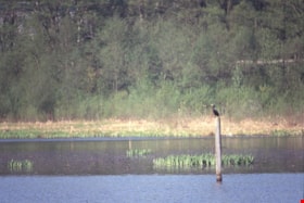
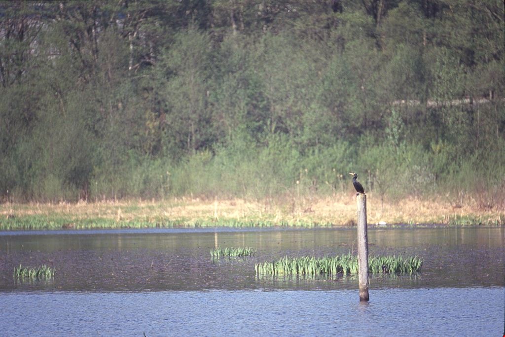
- File consists of photographs of cormorants. In three of the photographs cormorants are perched on wooded structures on Burnaby Lake; in the forth a cormorant is depicted taking flight from the water. The cormorants are medium-to-large sized birds with dark feathers and long, thin yellow bills.
- Repository
- City of Burnaby Archives
- Date
- 1982-1991
- Collection/Fonds
- Doreen Lawson fonds
- Physical Description
- 4 photographs : col. slides ; 35 mm
- Description Level
- File
- Record No.
- 618-004
- Access Restriction
- No restrictions
- Reproduction Restriction
- No restrictions
- Accession Number
- 2015-15
- Scope and Content
- File consists of photographs of cormorants. In three of the photographs cormorants are perched on wooded structures on Burnaby Lake; in the forth a cormorant is depicted taking flight from the water. The cormorants are medium-to-large sized birds with dark feathers and long, thin yellow bills.
- Media Type
- Photograph
- Photographer
- Lawson, Doreen A.
- Notes
- Transcribed title
- Title transcribed from note on slide sheet photographs were originally housed in
- Historic Neighbourhood
- Burnaby Lake (Historic Neighbourhood)
- Planning Study Area
- Burnaby Lake Area
Images

Fish
https://search.heritageburnaby.ca/link/archivedescription91687
- Repository
- City of Burnaby Archives
- Date
- 1982-1993
- Collection/Fonds
- Doreen Lawson fonds
- Description Level
- File
- Physical Description
- 37 photographs : col. slides ; 35 mm
- Scope and Content
- File consists of photographs of the Cariboo Dam situated along the Brunette River and Warner's fish lift located adjacent to the dam. Photographs depict the interior and exterior of the fish lift, the information sign for the lift, and a group of fisherman working in the river.
- Repository
- City of Burnaby Archives
- Date
- 1982-1993
- Collection/Fonds
- Doreen Lawson fonds
- Physical Description
- 37 photographs : col. slides ; 35 mm
- Description Level
- File
- Record No.
- 618-005
- Access Restriction
- No restrictions
- Reproduction Restriction
- May be restricted by third party rights
- Accession Number
- 2015-15
- Scope and Content
- File consists of photographs of the Cariboo Dam situated along the Brunette River and Warner's fish lift located adjacent to the dam. Photographs depict the interior and exterior of the fish lift, the information sign for the lift, and a group of fisherman working in the river.
- Media Type
- Photograph
- Photographer
- Lawson, Doreen A.
- Notes
- Transcribed title
- Title transcribed from binder divider photographs were originally housed behind.
- Note in red ink on recto of slide sheet photographs 618-005-11 : 618-005-23 originally housed in read: "Burnaby Lake / Warner's Fish Lift".
- Note in black ink on recto of slide sheet photographs 618-005-24 : 618-005-37 were originally housed in read: "Brunette River Dam".
- One of the fishermen is identified as Joe Calks in photograph 618-005-4
- Geographic Access
- Brunette River
- Burnaby Lake
- Historic Neighbourhood
- Burnaby Lake (Historic Neighbourhood)
- Planning Study Area
- Burnaby Lake Area
Images


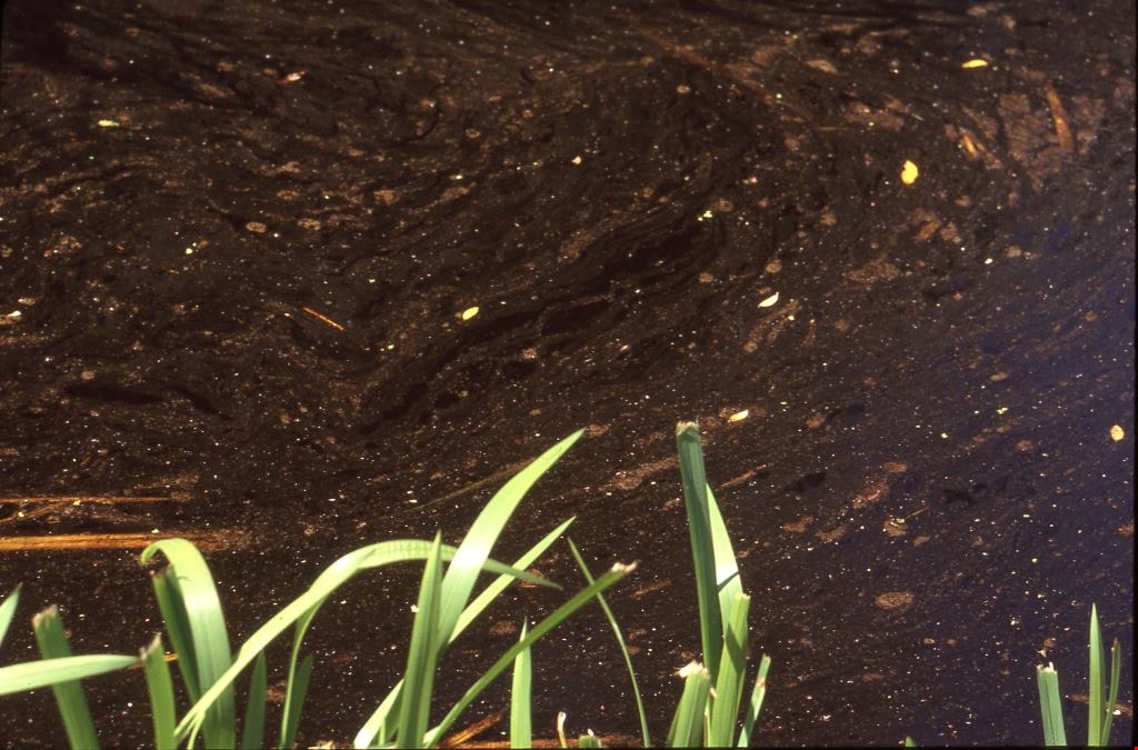
Burnaby Lake / Water Pollution - Oil
https://search.heritageburnaby.ca/link/archivedescription91691
- Repository
- City of Burnaby Archives
- Date
- 1982-1991
- Collection/Fonds
- Doreen Lawson fonds
- Description Level
- File
- Physical Description
- 13 photographs : col. slides ; 35 mm
- Scope and Content
- File consists of photographs of oil on the water surface of Burnaby Lake.
- Repository
- City of Burnaby Archives
- Date
- 1982-1991
- Collection/Fonds
- Doreen Lawson fonds
- Physical Description
- 13 photographs : col. slides ; 35 mm
- Description Level
- File
- Record No.
- 618-009
- Access Restriction
- No restrictions
- Reproduction Restriction
- No restrictions
- Accession Number
- 2015-15
- Scope and Content
- File consists of photographs of oil on the water surface of Burnaby Lake.
- Media Type
- Photograph
- Notes
- Transcribed title
- Title transcribed from note on slide sheet
- Historic Neighbourhood
- Burnaby Lake (Historic Neighbourhood)
- Planning Study Area
- Burnaby Lake Area
Images
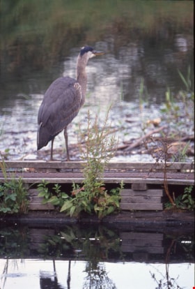
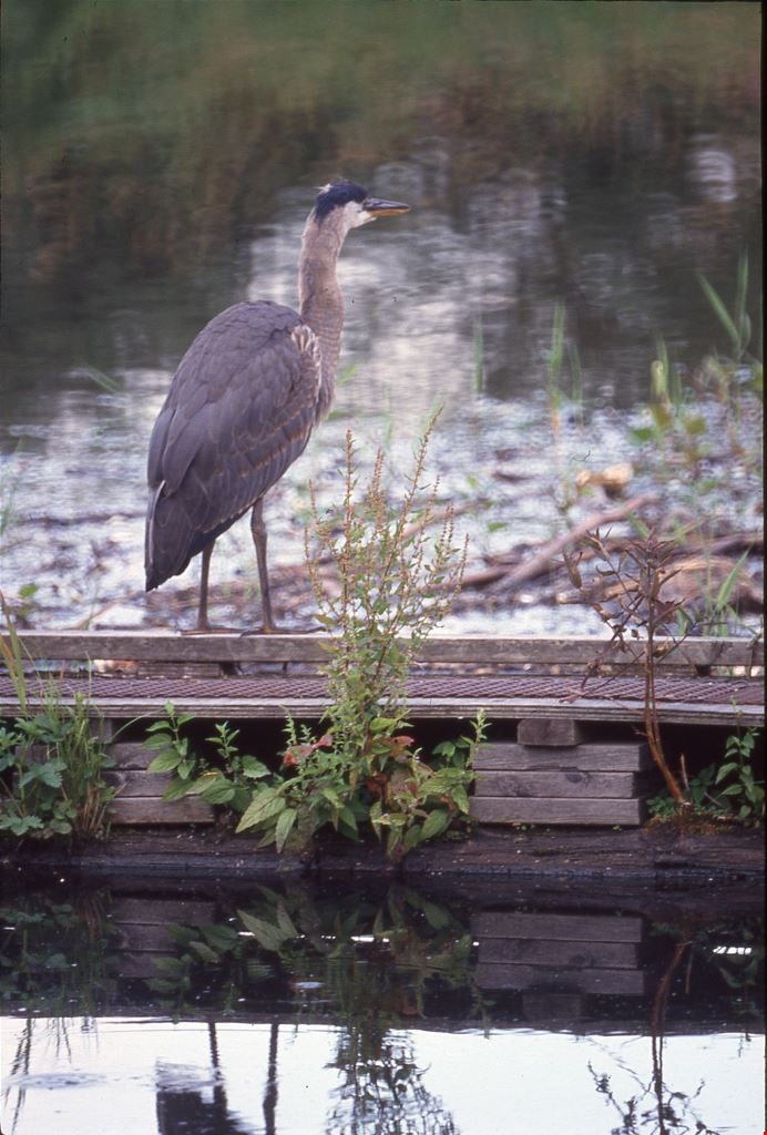
Great Blue Heron
https://search.heritageburnaby.ca/link/archivedescription91695
- Repository
- City of Burnaby Archives
- Date
- 1983-1991
- Collection/Fonds
- Doreen Lawson fonds
- Description Level
- File
- Physical Description
- 45 photographs : col. slides ; 35 mm
- Scope and Content
- File consists of photographs shot and compiled by Doreen Lawson of the great blue heron. Photographs depict the heron standing in the water, on a wooden pole, and along the banks of Burnaby Lake and Still Creek.
- Repository
- City of Burnaby Archives
- Date
- 1983-1991
- Collection/Fonds
- Doreen Lawson fonds
- Physical Description
- 45 photographs : col. slides ; 35 mm
- Description Level
- File
- Record No.
- 618-013
- Access Restriction
- No restrictions
- Reproduction Restriction
- No restrictions
- Accession Number
- 2015-15
- Scope and Content
- File consists of photographs shot and compiled by Doreen Lawson of the great blue heron. Photographs depict the heron standing in the water, on a wooden pole, and along the banks of Burnaby Lake and Still Creek.
- Media Type
- Photograph
- Photographer
- Lawson, Doreen A.
- Notes
- Title based on contents of photographs
- Note in blue ink on recto of slide sheet photographs 618-013-1 : 618-013-003 originally housed in read: "Burnaby Lake Herons."
- Note in blue ink on recto of slide sheet photographs 618-013-4 : 618-013-21 originally housed in read: "Still Creek / Great Blue Heron / July 91"
- Note in blue ink on recto of slide sheet photographs 618-013-22 : 618-013-30 originally housed in read: "Great Blue Heron / Still Creek / July 91"
- Geographic Access
- Burnaby Lake
- Still Creek
- Historic Neighbourhood
- Burnaby Lake (Historic Neighbourhood)
- Planning Study Area
- Burnaby Lake Area
Images

Burnaby Lake
https://search.heritageburnaby.ca/link/archivedescription91701
- Repository
- City of Burnaby Archives
- Date
- March 1982 - April 1982
- Collection/Fonds
- Doreen Lawson fonds
- Description Level
- File
- Physical Description
- 17 photographs : col. slides ; 35 mm
- Scope and Content
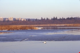
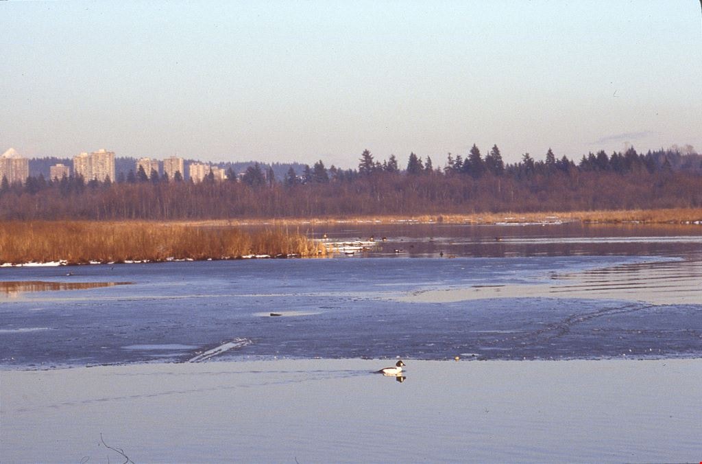
- File consists photographs of Burnaby Lake taken in late winter. The foliage around the lake is primarily brown and wilted with the first new growth of Spring just emerging. Canadian geese swim on the lake in the foreground of several of the photographs, with snow-covered mountains and the Loughee…
- Repository
- City of Burnaby Archives
- Date
- March 1982 - April 1982
- Collection/Fonds
- Doreen Lawson fonds
- Physical Description
- 17 photographs : col. slides ; 35 mm
- Description Level
- File
- Record No.
- 618-019
- Access Restriction
- No restrictions
- Reproduction Restriction
- No restrictions
- Accession Number
- 2015-15
- Scope and Content
- File consists photographs of Burnaby Lake taken in late winter. The foliage around the lake is primarily brown and wilted with the first new growth of Spring just emerging. Canadian geese swim on the lake in the foreground of several of the photographs, with snow-covered mountains and the Lougheed Mall skyline visible in the distance. Also included in the file is one photograph of the forest alongside the Brunette River.
- Media Type
- Photograph
- Photographer
- Lawson, Doreen A.
- Notes
- Transcribed title
- Title transcribed from label on slide sheets photographs originally housed in
- Geographic Access
- Burnaby Lake
- Brunette River
- Historic Neighbourhood
- Burnaby Lake (Historic Neighbourhood)
- Planning Study Area
- Burnaby Lake Area
Images

Burnaby Lake / Ambience
https://search.heritageburnaby.ca/link/archivedescription91690
- Repository
- City of Burnaby Archives
- Date
- 1983-1993
- Collection/Fonds
- Doreen Lawson fonds
- Description Level
- File
- Physical Description
- 15 photographs : col. slides ; 35 mm
- Scope and Content
- File consists of scenic photographs of Burnaby Lake compiled by Doreen Lawson. Photographs depict the lake in all seasons with the lake in the foreground and the forest and skyline in the distance. Photographs were taken during daylight and twilight.
- Repository
- City of Burnaby Archives
- Date
- 1983-1993
- Collection/Fonds
- Doreen Lawson fonds
- Physical Description
- 15 photographs : col. slides ; 35 mm
- Description Level
- File
- Record No.
- 618-008
- Access Restriction
- No restrictions
- Reproduction Restriction
- No restrictions
- Accession Number
- 2015-15
- Scope and Content
- File consists of scenic photographs of Burnaby Lake compiled by Doreen Lawson. Photographs depict the lake in all seasons with the lake in the foreground and the forest and skyline in the distance. Photographs were taken during daylight and twilight.
- Media Type
- Photograph
- Notes
- Transcribed title
- Title transcribed from note on slide sheet
- Historic Neighbourhood
- Burnaby Lake (Historic Neighbourhood)
- Planning Study Area
- Burnaby Lake Area
Images


Lougheed Mall skyline at night
https://search.heritageburnaby.ca/link/archivedescription91699
- Repository
- City of Burnaby Archives
- Date
- 1986-1989
- Collection/Fonds
- Doreen Lawson fonds
- Description Level
- File
- Physical Description
- 6 photographs : col. slides ; 35 mm
- Scope and Content
- File consists of scenic photographs of Burnaby Lake at sunset and nighttime with the Lougheed Mall skyline lit up in the distance.
- Repository
- City of Burnaby Archives
- Date
- 1986-1989
- Collection/Fonds
- Doreen Lawson fonds
- Physical Description
- 6 photographs : col. slides ; 35 mm
- Description Level
- File
- Record No.
- 618-017
- Access Restriction
- No restrictions
- Reproduction Restriction
- No restrictions
- Accession Number
- 2015-15
- Scope and Content
- File consists of scenic photographs of Burnaby Lake at sunset and nighttime with the Lougheed Mall skyline lit up in the distance.
- Media Type
- Photograph
- Photographer
- Lawson, Doreen A.
- Notes
- Title based on contents of photographs
- Historic Neighbourhood
- Burnaby Lake (Historic Neighbourhood)
- Planning Study Area
- Burnaby Lake Area
Images

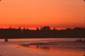
Lougheed Mall skyline at night
https://search.heritageburnaby.ca/link/archivedescription91700
- Repository
- City of Burnaby Archives
- Date
- March 1985
- Collection/Fonds
- Doreen Lawson fonds
- Description Level
- File
- Physical Description
- 11 photographs : col. slides ; 35 mm
- Scope and Content
- File consists of scenic photographs of Burnaby Lake at sunset with the forest and skyline silhouetted in the background.
- Repository
- City of Burnaby Archives
- Date
- March 1985
- Collection/Fonds
- Doreen Lawson fonds
- Physical Description
- 11 photographs : col. slides ; 35 mm
- Description Level
- File
- Record No.
- 618-018
- Access Restriction
- No restrictions
- Reproduction Restriction
- No restrictions
- Accession Number
- 2015-15
- Scope and Content
- File consists of scenic photographs of Burnaby Lake at sunset with the forest and skyline silhouetted in the background.
- Media Type
- Photograph
- Photographer
- Lawson, Doreen A.
- Notes
- Title based on contents of photographs
- Historic Neighbourhood
- Burnaby Lake (Historic Neighbourhood)
- Planning Study Area
- Burnaby Lake Area
Images
