Narrow Results By
Subject
- Advertising Medium - Signs and Signboards 1
- Agriculture - Farms 23
- Agriculture - Poultry 1
- Animals - Birds 1
- Animals - Dogs 2
- Animals - Horses 5
- Animals - Poultry 1
- Buildings 1
- Buildings - Agricultural - Barns 6
- Buildings - Agricultural - Greenhouses 2
- Buildings - Civic 1
- Buildings - Civic - City Halls 17
![Officer Clegg at Oakalla, [195-] (date of original), copied 1991 thumbnail](/media/hpo/_Data/_Archives_Images/_Unrestricted/370/370-728.jpg?width=280)
Officer Clegg at Oakalla
https://search.heritageburnaby.ca/link/archivedescription38141
- Repository
- City of Burnaby Archives
- Date
- [195-] (date of original), copied 1991
- Collection/Fonds
- Burnaby Historical Society fonds
- Description Level
- Item
- Physical Description
- 1 photograph : b&w ; 3.2 x 4.4 cm print on contact sheet 19.8 x 26.2 cm
- Scope and Content
- Photograph of Officer Clegg, with drug rehabilitation projects in yard at Oakalla Prison Farm.
- Repository
- City of Burnaby Archives
- Date
- [195-] (date of original), copied 1991
- Collection/Fonds
- Burnaby Historical Society fonds
- Subseries
- Burnaby Image Bank subseries
- Physical Description
- 1 photograph : b&w ; 3.2 x 4.4 cm print on contact sheet 19.8 x 26.2 cm
- Description Level
- Item
- Record No.
- 370-728
- Access Restriction
- No restrictions
- Reproduction Restriction
- Reproduce for fair dealing purposes only
- Accession Number
- BHS1999-03
- Scope and Content
- Photograph of Officer Clegg, with drug rehabilitation projects in yard at Oakalla Prison Farm.
- Subjects
- Clothing - Uniforms
- Media Type
- Photograph
- Notes
- Title based on contents of photograph
- 1 b&w copy negative accompanying
- Negative has a pink cast
- Geographic Access
- Oakmount Crescent
- Street Address
- 5220 Oakmount Crescent
- Historic Neighbourhood
- Burnaby Lake (Historic Neighbourhood)
- Planning Study Area
- Oakalla Area
Images
![Officer Clegg at Oakalla, [195-] (date of original), copied 1991 thumbnail](/media/hpo/_Data/_Archives_Images/_Unrestricted/370/370-728.jpg)
![School room at Oakalla, [195-] (date of original), copied 1991 thumbnail](/media/hpo/_Data/_Archives_Images/_Unrestricted/370/370-733.jpg?width=280)
School room at Oakalla
https://search.heritageburnaby.ca/link/archivedescription38146
- Repository
- City of Burnaby Archives
- Date
- [195-] (date of original), copied 1991
- Collection/Fonds
- Burnaby Historical Society fonds
- Description Level
- Item
- Physical Description
- 1 photograph : b&w ; 3.6 x 4.4 cm print on contact sheet 20.6 x 26.8 cm
- Scope and Content
- Photograph of the interior of a school room at Oakalla Prison Farm. Men are seated at desks, and a student and teacher are at the blackboard standing beside a map. A list of words is on the blackboard.
- Repository
- City of Burnaby Archives
- Date
- [195-] (date of original), copied 1991
- Collection/Fonds
- Burnaby Historical Society fonds
- Subseries
- Burnaby Image Bank subseries
- Physical Description
- 1 photograph : b&w ; 3.6 x 4.4 cm print on contact sheet 20.6 x 26.8 cm
- Description Level
- Item
- Record No.
- 370-733
- Access Restriction
- No restrictions
- Reproduction Restriction
- Reproduce for fair dealing purposes only
- Accession Number
- BHS1999-03
- Scope and Content
- Photograph of the interior of a school room at Oakalla Prison Farm. Men are seated at desks, and a student and teacher are at the blackboard standing beside a map. A list of words is on the blackboard.
- Subjects
- Documentary Artifacts - Maps
- Buildings - Public - Detention Facilities
- Buildings - Schools
- Occupations - Teachers
- Names
- Oakalla Prison Farm
- Media Type
- Photograph
- Notes
- Title based on contents of photograph
- 1 b&w copy negative accompanying
- Negative has a pink cast
- Geographic Access
- Oakmount Crescent
- Street Address
- 5220 Oakmount Crescent
- Historic Neighbourhood
- Burnaby Lake (Historic Neighbourhood)
- Planning Study Area
- Oakalla Area
Images
![School room at Oakalla, [195-] (date of original), copied 1991 thumbnail](/media/hpo/_Data/_Archives_Images/_Unrestricted/370/370-733.jpg)
![Isolation Unit at Oakalla, [195-] (date of original), copied 1991 thumbnail](/media/hpo/_Data/_Archives_Images/_Unrestricted/370/370-734.jpg?width=280)
Isolation Unit at Oakalla
https://search.heritageburnaby.ca/link/archivedescription38147
- Repository
- City of Burnaby Archives
- Date
- [195-] (date of original), copied 1991
- Collection/Fonds
- Burnaby Historical Society fonds
- Description Level
- Item
- Physical Description
- 1 photograph : b&w ; 3.4 x 4.2 cm print on contact sheet 20.6 x 26.8 cm
- Scope and Content
- Photograph of the cells in the main isolation unit at Oakalla Prison Farm. The isolation centre was known as " the Hole."
- Repository
- City of Burnaby Archives
- Date
- [195-] (date of original), copied 1991
- Collection/Fonds
- Burnaby Historical Society fonds
- Subseries
- Burnaby Image Bank subseries
- Physical Description
- 1 photograph : b&w ; 3.4 x 4.2 cm print on contact sheet 20.6 x 26.8 cm
- Description Level
- Item
- Record No.
- 370-734
- Access Restriction
- No restrictions
- Reproduction Restriction
- Reproduce for fair dealing purposes only
- Accession Number
- BHS1999-03
- Scope and Content
- Photograph of the cells in the main isolation unit at Oakalla Prison Farm. The isolation centre was known as " the Hole."
- Names
- Oakalla Prison Farm
- Media Type
- Photograph
- Notes
- Title based on contents of photograph
- 1 b&w copy negative accompanying
- Negative has a pink cast
- Geographic Access
- Oakmount Crescent
- Street Address
- 5220 Oakmount Crescent
- Historic Neighbourhood
- Burnaby Lake (Historic Neighbourhood)
- Planning Study Area
- Oakalla Area
Images
![Isolation Unit at Oakalla, [195-] (date of original), copied 1991 thumbnail](/media/hpo/_Data/_Archives_Images/_Unrestricted/370/370-734.jpg)
![Isolation Unit at Oakalla, [195-] (date of original), copied 1991 thumbnail](/media/hpo/_Data/_Archives_Images/_Unrestricted/370/370-735.jpg?width=280)
Isolation Unit at Oakalla
https://search.heritageburnaby.ca/link/archivedescription38148
- Repository
- City of Burnaby Archives
- Date
- [195-] (date of original), copied 1991
- Collection/Fonds
- Burnaby Historical Society fonds
- Description Level
- Item
- Physical Description
- 1 photograph : b&w ; 3.5 x 4.2 cm print on contact sheet 20.6 x 26.8 cm
- Scope and Content
- Photograph of the cells in the main isolation unit at Oakalla Prison Farm with the doors open. The isolation centre was known as " the Hole." A man is standing at the back left of the photo.
- Repository
- City of Burnaby Archives
- Date
- [195-] (date of original), copied 1991
- Collection/Fonds
- Burnaby Historical Society fonds
- Subseries
- Burnaby Image Bank subseries
- Physical Description
- 1 photograph : b&w ; 3.5 x 4.2 cm print on contact sheet 20.6 x 26.8 cm
- Description Level
- Item
- Record No.
- 370-735
- Access Restriction
- No restrictions
- Reproduction Restriction
- Reproduce for fair dealing purposes only
- Accession Number
- BHS1999-03
- Scope and Content
- Photograph of the cells in the main isolation unit at Oakalla Prison Farm with the doors open. The isolation centre was known as " the Hole." A man is standing at the back left of the photo.
- Names
- Oakalla Prison Farm
- Media Type
- Photograph
- Notes
- Title based on contents of photograph
- 1 b&w copy negative accompanying
- Negative has a pink cast
- Geographic Access
- Oakmount Crescent
- Street Address
- 5220 Oakmount Crescent
- Historic Neighbourhood
- Burnaby Lake (Historic Neighbourhood)
- Planning Study Area
- Oakalla Area
Images
![Isolation Unit at Oakalla, [195-] (date of original), copied 1991 thumbnail](/media/hpo/_Data/_Archives_Images/_Unrestricted/370/370-735.jpg)
![Mathers House, [1950] thumbnail](/media/hpo/_Data/_Archives_Images/_Unrestricted/371/405-005.jpg?width=280)
Mathers House
https://search.heritageburnaby.ca/link/archivedescription39808
- Repository
- City of Burnaby Archives
- Date
- [1950]
- Collection/Fonds
- Burnaby Historical Society fonds
- Description Level
- Item
- Physical Description
- 1 photograph : b&w ; 6.5 x 8.2 cm
- Scope and Content
- Photograph of the Mathers house at Deer Lake, which also served as the Seminary of Christ the King.
- Repository
- City of Burnaby Archives
- Date
- [1950]
- Collection/Fonds
- Burnaby Historical Society fonds
- Subseries
- Photographs subseries
- Physical Description
- 1 photograph : b&w ; 6.5 x 8.2 cm
- Description Level
- Item
- Record No.
- 405-005
- Access Restriction
- No restrictions
- Reproduction Restriction
- Reproduce for fair dealing purposes only
- Accession Number
- BHS2000-5
- Scope and Content
- Photograph of the Mathers house at Deer Lake, which also served as the Seminary of Christ the King.
- Subjects
- Buildings - Heritage
- Media Type
- Photograph
- Notes
- Title based on contents of photograph
- Geographic Access
- Deer Lake Avenue
- Street Address
- 6490 Deer Lake Avenue
- Historic Neighbourhood
- Burnaby Lake (Historic Neighbourhood)
- Planning Study Area
- Douglas-Gilpin Area
Images
![Mathers House, [1950] thumbnail](/media/hpo/_Data/_Archives_Images/_Unrestricted/371/405-005.jpg)

Interview with Sev Morin by Rod Fowler April 4, 1990 - Track 2
https://search.heritageburnaby.ca/link/oralhistory538
- Repository
- City of Burnaby Archives
- Date Range
- 1950-1990
- Length
- 00:06:16
- Summary
- This portion of the interview is about Sev Morin’s description of Burnaby’s growth and business development along Kingsway and Hastings, the Lake City Industrial Park, and the purchase of property in 1958 for the Heritage Park and Art Gallery.
- Repository
- City of Burnaby Archives
- Summary
- This portion of the interview is about Sev Morin’s description of Burnaby’s growth and business development along Kingsway and Hastings, the Lake City Industrial Park, and the purchase of property in 1958 for the Heritage Park and Art Gallery.
- Date Range
- 1950-1990
- Photo Info
- Sev Morin (left) of Severin's in Burnaby (formerly the Gai Paree) hosting a gala New Year's celebration, 1979. Item no. 480-712
- Length
- 00:06:16
- Subjects
- Buildings - Commercial
- Buildings - Civic
- Buildings - Industrial
- Buildings - Schools - Universities and Colleges
- Historic Neighbourhood
- Central Park (Historic Neighbourhood)
- Burnaby Lake (Historic Neighbourhood)
- Vancouver Heights (Historic Neighbourhood)
- Edmonds (Historic Neighbourhood)
- Planning Study Area
- Burnaby Heights Area
- Lake City Area
- Burnaby Mountain Area
- Kingsway-Beresford Area
- Douglas-Gilpin Area
- Interviewer
- Fowler, Rod
- Interview Date
- April 4, 1990
- Scope and Content
- Recording is of an interview with Severin "Sev" Morin, conducted by Rod Fowler. Sev Morin was one of eleven participants interviewed as part of the SFU/Burnaby Centennial Committee's oral history series titled, "Voices of Burnaby". The interview is mainly about Sev Morin’s banquet hall, restaurant and night club business on Kingsway, originally named the “Gai Paree Supper Club” (1947-1976) and later “Severin’s” (1976-1985) and “Diego’s” (1985-1994), its function as a Burnaby landmark, and the entertainment and political people he met through his business. He also describes his many volunteer activities in Burnaby, including member of the SFU Senate, Rotary Club, Variety Club and Telethon, fund raising for Burnaby Hospital, and tourism related groups, and his political work for the federal Liberal party. He talks about his parents’ origins, the lives of his brothers Rudy and Rene, and the family’s involvement in establishing the “Gai Paree”. He also shares his views about the business and cultural development of Burnaby. To view “Narrow By” terms for each track expand this description and see “Notes”.
- Biographical Notes
- Severin “Sev” Rene Morin was born September 21, 1927, in Bonneville, Alberta, to Rene Pierre Morin (1878-1963) and Anne Marie (nee Lachiver) Morin (1886-1956). Mr. and Mrs. R. P. Morin and their son Rene Francois (1905-1954) immigrated to Edmonton, Alberta, from France in 1913, where Rene Pierre Morin worked for the C.N.R. and a second son Adolphe “Rudy” Ferdinand (1922-1969) was born, followed by their third son Severin. In 1943, after R.P. Morin retired, the family moved to Burnaby to a house on Sperling Avenue. Sometime earlier the two older Morin brothers found work in Trail at the smelter and developed musical careers. In 1946/47 the Morin family purchased property on Kingsway and built a banquet hall, the “Gai Paree Supper Club”. Sev and Rudy Morin managed the club and Rene F. Morin moved to Burnaby to join them with his band. The supper club, with its live music and dance floor, became a popular meeting place and wedding venue, eventually expanding into a restaurant and nightclub in the 1970s. The “Gai Paree” was renamed “Severin’s” in 1976 and “Diego’s” in 1985, closing finally in 1994. Sev Morin’s business life included three record stores which he owned with his friend Jack Cullen. Through these businesses Sev Morin was well known in the entertainment and hospitality industry. He and his restaurant also hosted political and social events that made the restaurant a community landmark. Sev Morin contributed many volunteer hours to community and charitable organizations, including an appointment to the SFU Senate, fundraising for the Burnaby Hospital, Director of the Variety Club and Rotary Club, and consultant for a variety of tourism related ventures. He also was active in the federal Liberal Party. Sev Morin and his wife Pauline married in 1950 and had three children. Sev Morin died at age 86 on March 28, 2014.
- Total Tracks
- 10
- Total Length
- 00:56:44
- Interviewee Name
- Morin, Severin "Sev"
- Interviewer Bio
- Rod Fowler returned to university as a mature student in the 1980s after working about twenty years in the field of economics and computerization in business in England, Europe and Western Canada. He graduated with a BA from SFU in both History and Sociology in 1987, his MA degree in Geography in 1989, and his PhD in Cultural Geography at SFU. He taught courses in Geography, Sociology, History and Canadian Studies at several Lower Mainland colleges, before becoming a full time member of the Geography Department at Kwantlen University College.
- Collection/Fonds
- SFU/Burnaby Centennial Committee fonds
- Transcript Available
- Transcript available
- Media Type
- Sound Recording
- Web Notes
- Interviews were digitized in 2015 allowing them to be accessible on Heritage Burnaby. The digitization project was initiated by the Community Heritage Commission with support from City of Burnaby Council.
Images

Audio Tracks
Track two of interview with Sev Morin
Track two of interview with Sev Morin
https://search.heritageburnaby.ca/media/hpo/_Data/_Archives_Oral_Histories/_Unrestricted/MSS187-021/MSS187-021_Track%202.mp3![Suey Ying Jung (Laura) sitting in front of rocks, [between 1950 and 1955] thumbnail](/media/hpo/_Data/_BVM_Images/2017/2017_0024_0029_001.jpg?width=280)
Suey Ying Jung (Laura) sitting in front of rocks
https://search.heritageburnaby.ca/link/museumdescription4076
- Repository
- Burnaby Village Museum
- Date
- [between 1950 and 1955]
- Collection/Fonds
- Julie Lee and Cecil Lee family fonds
- Description Level
- Item
- Physical Description
- 1 photograph (tiff) : sepia ; 1200 dpi
- Scope and Content
- Photograph of Suey Ying Jung (Laura) sitting in front of rocks on family property.
- Repository
- Burnaby Village Museum
- Collection/Fonds
- Julie Lee and Cecil Lee family fonds
- Description Level
- Item
- Physical Description
- 1 photograph (tiff) : sepia ; 1200 dpi
- Scope and Content
- Photograph of Suey Ying Jung (Laura) sitting in front of rocks on family property.
- Subjects
- Persons - Chinese Canadians
- Names
- Jung, Suey Ying "Laura"
- Accession Code
- BV017.24.29
- Access Restriction
- No restrictions
- Reproduction Restriction
- No known restrictions
- Date
- [between 1950 and 1955]
- Media Type
- Photograph
- Historic Neighbourhood
- Burnaby Lake (Historic Neighbourhood)
- Planning Study Area
- Douglas-Gilpin Area
- Scan Resolution
- 1200
- Scan Date
- 01-Oct-2017
- Scale
- 100
- Notes
- Title based on contents of photograph
Images
![Suey Ying Jung (Laura) sitting in front of rocks, [between 1950 and 1955] thumbnail](/media/hpo/_Data/_BVM_Images/2017/2017_0024_0029_001.jpg)
![Suey Ying Jung (Laura) crouching with dog, [between 1950 and 1955] thumbnail](/media/hpo/_Data/_BVM_Images/2017/2017_0024_0030_001.jpg?width=280)
Suey Ying Jung (Laura) crouching with dog
https://search.heritageburnaby.ca/link/museumdescription4077
- Repository
- Burnaby Village Museum
- Date
- [between 1950 and 1955]
- Collection/Fonds
- Julie Lee and Cecil Lee family fonds
- Description Level
- Item
- Physical Description
- 1 photograph (tiff) : sepia ; 1200 dpi
- Scope and Content
- Photograph of Suey Ying Jung (Laura) crouching in front of lattice with dog; garden in background.
- Repository
- Burnaby Village Museum
- Collection/Fonds
- Julie Lee and Cecil Lee family fonds
- Description Level
- Item
- Physical Description
- 1 photograph (tiff) : sepia ; 1200 dpi
- Scope and Content
- Photograph of Suey Ying Jung (Laura) crouching in front of lattice with dog; garden in background.
- Subjects
- Persons - Chinese Canadians
- Names
- Jung, Suey Ying "Laura"
- Accession Code
- BV017.24.30
- Access Restriction
- No restrictions
- Reproduction Restriction
- No known restrictions
- Date
- [between 1950 and 1955]
- Media Type
- Photograph
- Historic Neighbourhood
- Burnaby Lake (Historic Neighbourhood)
- Planning Study Area
- Douglas-Gilpin Area
- Scan Resolution
- 1200
- Scan Date
- 01-Oct-2017
- Scale
- 100
- Notes
- Title based on contents of photograph
Images
![Suey Ying Jung (Laura) crouching with dog, [between 1950 and 1955] thumbnail](/media/hpo/_Data/_BVM_Images/2017/2017_0024_0030_001.jpg)
![Boal family home, [1950] thumbnail](/media/hpo/_Data/_BVM_Images/2017/201700280022_001.jpg?width=280)
Boal family home
https://search.heritageburnaby.ca/link/museumdescription4215
- Repository
- Burnaby Village Museum
- Date
- [1950]
- Collection/Fonds
- Burnaby Village Museum Photograph collection
- Description Level
- Item
- Physical Description
- 1 photograph : b&w ; 6.5 x 9 cm
- Scope and Content
- Photograph of the Boal home at 4319 Norland Ave in Burnaby. This is a three-quarter shot of the house which has new, light coloured siding (white?) and a garage in the back. A man is mowing the lawn next to the house.
- Repository
- Burnaby Village Museum
- Collection/Fonds
- Burnaby Village Museum Photograph collection
- Description Level
- Item
- Physical Description
- 1 photograph : b&w ; 6.5 x 9 cm
- Material Details
- Handwritten text in ink on front of photograph reads: "1950".
- Stamped numeral on back of photograph reads: "452".
- Handwritten text on back of photograph reads: "summer, 1950 / Boals' house".
- Scope and Content
- Photograph of the Boal home at 4319 Norland Ave in Burnaby. This is a three-quarter shot of the house which has new, light coloured siding (white?) and a garage in the back. A man is mowing the lawn next to the house.
- History
- Material belonged to Glen and Ann Boal (nee Lockhart), who grew up in Burnaby and attended Burnaby South High School. They met and became engaged and married in 1954.
- Geographic Access
- Norland Avenue
- Street Address
- 4319 Norland Avenue
- Accession Code
- BV017.28.22
- Access Restriction
- No restrictions
- Reproduction Restriction
- No known restrictions
- Date
- [1950]
- Media Type
- Photograph
- Historic Neighbourhood
- Burnaby Lake (Historic Neighbourhood)
- Planning Study Area
- Burnaby Lake Area
- Scan Resolution
- 600
- Scan Date
- 06-Mar-2018
- Notes
- Title based on contents of photograph
Images
![Boal family home, [1950] thumbnail](/media/hpo/_Data/_BVM_Images/2017/201700280022_001.jpg)
![Boal family home, [195-] thumbnail](/media/hpo/_Data/_BVM_Images/2017/201700280023_001.jpg?width=280)
Boal family home
https://search.heritageburnaby.ca/link/museumdescription4216
- Repository
- Burnaby Village Museum
- Date
- [195-]
- Collection/Fonds
- Burnaby Village Museum Photograph collection
- Description Level
- Item
- Physical Description
- 1 photograph : col. ; 9 x 13 cm
- Scope and Content
- Photograph of the Boal home at 4319 Norland Ave in Burnaby. This is a three-quarter shot of the house. The house has been altered by enclosing the front porch and lowering the front door to ground level. Doors and window sills are painted light blue. Window shutters have been added. The house is wh…
- Repository
- Burnaby Village Museum
- Collection/Fonds
- Burnaby Village Museum Photograph collection
- Description Level
- Item
- Physical Description
- 1 photograph : col. ; 9 x 13 cm
- Scope and Content
- Photograph of the Boal home at 4319 Norland Ave in Burnaby. This is a three-quarter shot of the house. The house has been altered by enclosing the front porch and lowering the front door to ground level. Doors and window sills are painted light blue. Window shutters have been added. The house is white. There are trees in full leaf around the house.
- History
- Material belonged to Glen and Ann Boal (nee Lockhart), who grew up in Burnaby and attended Burnaby South High School. They met and became engaged and married in 1954.
- Geographic Access
- Norland Avenue
- Street Address
- 4319 Norland Avenue
- Accession Code
- BV017.28.23
- Access Restriction
- No restrictions
- Reproduction Restriction
- No known restrictions
- Date
- [195-]
- Media Type
- Photograph
- Historic Neighbourhood
- Burnaby Lake (Historic Neighbourhood)
- Planning Study Area
- Burnaby Lake Area
- Scan Resolution
- 600
- Scan Date
- 06-Mar-2018
- Notes
- Title based on contents of photograph
Images
![Boal family home, [195-] thumbnail](/media/hpo/_Data/_BVM_Images/2017/201700280023_001.jpg)
![Edith Fleming and Duke, [ca. 1950s] thumbnail](/media/Hpo/_Data/_BVM_Images/2016/2016_0046_0114_001.jpg?width=280)
Edith Fleming and Duke
https://search.heritageburnaby.ca/link/museumdescription5159
- Repository
- Burnaby Village Museum
- Date
- [ca. 1950s]
- Collection/Fonds
- Waplington family fonds
- Description Level
- Item
- Physical Description
- 1 photograph : b&w ; 6 x 4 cm
- Scope and Content
- Photograph of Edith (Edie) Fleming and dog "Duke" outside the Waplington/Fleming home at 3813 Deer Lake Avenue. This photograph was pasted in orignal scrapbook with a typewritten story titled "Duke and the Pill".
- Repository
- Burnaby Village Museum
- Collection/Fonds
- Waplington family fonds
- Description Level
- Item
- Physical Description
- 1 photograph : b&w ; 6 x 4 cm
- Scope and Content
- Photograph of Edith (Edie) Fleming and dog "Duke" outside the Waplington/Fleming home at 3813 Deer Lake Avenue. This photograph was pasted in orignal scrapbook with a typewritten story titled "Duke and the Pill".
- Subjects
- Animals - Dogs
- Geographic Access
- Deer Lake Avenue
- Street Address
- 3813 Deer Lake Avenue
- Accession Code
- BV016.46.114
- Access Restriction
- No restrictions
- Reproduction Restriction
- No known restrictions
- Date
- [ca. 1950s]
- Media Type
- Photograph
- Historic Neighbourhood
- Burnaby Lake (Historic Neighbourhood)
- Planning Study Area
- Morley-Buckingham Area
- Scan Resolution
- 600
- Scan Date
- 13-Aug-2018
- Notes
- Title based on information from photograph album
- Photograph is part of Photograph album BV016.46.52
Images
![Edith Fleming and Duke, [ca. 1950s] thumbnail](/media/Hpo/_Data/_BVM_Images/2016/2016_0046_0114_001.jpg)

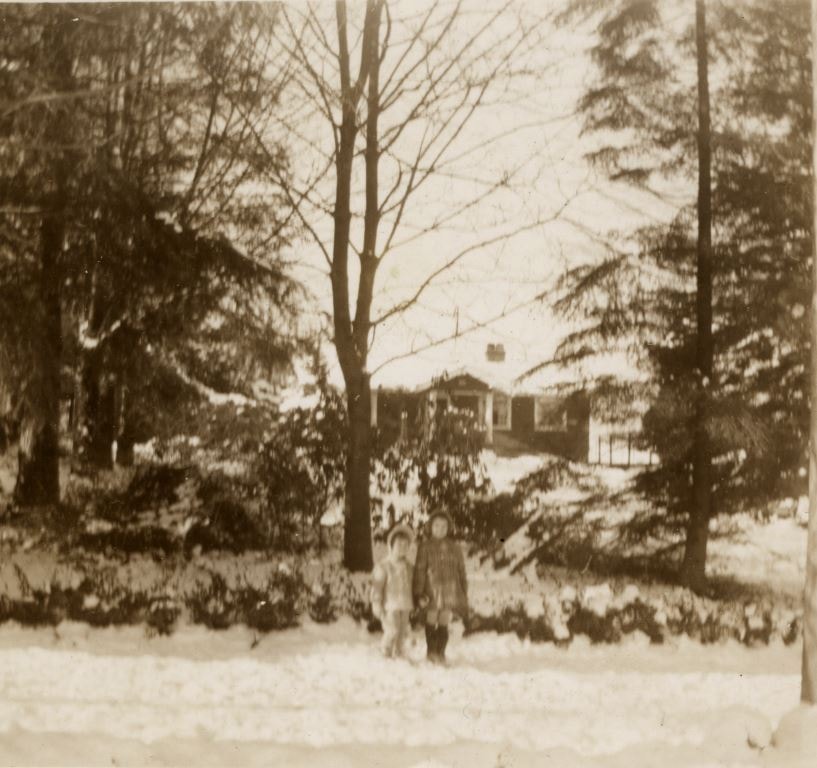
Looking west from Douglas Road
https://search.heritageburnaby.ca/link/archivedescription91831
- Repository
- City of Burnaby Archives
- Date
- 1951
- Collection/Fonds
- Small family fonds
- Description Level
- Item
- Physical Description
- 1 photograph : b&w ; 12.5 cm x 9 cm
- Scope and Content
- Photograph of Kathryn and Elizabeth Small standing in front of the Roberts' house at 5118 Douglas Road. Snow covers the ground, trees, and house and the girls wear winter coats. The photograph was taken from Douglas Road, looking west.
- Repository
- City of Burnaby Archives
- Date
- 1951
- Collection/Fonds
- Small family fonds
- Physical Description
- 1 photograph : b&w ; 12.5 cm x 9 cm
- Description Level
- Item
- Record No.
- 620-012
- Access Restriction
- No restrictions
- Reproduction Restriction
- No reproduction permitted
- Accession Number
- 2017-01
- Scope and Content
- Photograph of Kathryn and Elizabeth Small standing in front of the Roberts' house at 5118 Douglas Road. Snow covers the ground, trees, and house and the girls wear winter coats. The photograph was taken from Douglas Road, looking west.
- Media Type
- Photograph
- Notes
- Transcribed title
- Title transcribed from donor's notes
- Note in black ink on verso of photograph reads: "Kathryn and Elizabeth / Jan [struck through] 1951"
- Note in blue ink on verso of photograph reads: "March?"
- Note in blue ink on verso of photograph reads: "P.12"
- Stamp in black ink on verso of photograph reads: "754"
- 5118 Douglas Road renumbered to 3131 Douglas Road in 1958 and to 5538 Dominion Street in 1970 or 1971
- Street Address
- 3131 Douglas Road
- 5118 Douglas Road
- 5538 Dominion Street
- Historic Neighbourhood
- Burnaby Lake (Historic Neighbourhood)
- Planning Study Area
- Ardingley-Sprott Area
Images
![Back yard of 5118 Douglas Road, [1951] thumbnail](/media/hpo/_Data/_Archives_Images/_Unrestricted/600/620-019.jpg?width=280)
Back yard of 5118 Douglas Road
https://search.heritageburnaby.ca/link/archivedescription91838
- Repository
- City of Burnaby Archives
- Date
- [1951]
- Collection/Fonds
- Small family fonds
- Description Level
- Item
- Physical Description
- 1 photograph : b&w ; 7 cm x 11.5 cm
- Scope and Content
- Photograph of the backyard and screened summer house at 5118 Douglas Road after a snowfall. The summer house was used by the Roberts children for sleeping outdoors in the summertime and by the Small children as a playhouse. It rotted and collapsed in the 1960s, likely following the "Big Snow" of …
- Repository
- City of Burnaby Archives
- Date
- [1951]
- Collection/Fonds
- Small family fonds
- Physical Description
- 1 photograph : b&w ; 7 cm x 11.5 cm
- Description Level
- Item
- Record No.
- 620-019
- Access Restriction
- No restrictions
- Reproduction Restriction
- No reproduction permitted
- Accession Number
- 2017-01
- Scope and Content
- Photograph of the backyard and screened summer house at 5118 Douglas Road after a snowfall. The summer house was used by the Roberts children for sleeping outdoors in the summertime and by the Small children as a playhouse. It rotted and collapsed in the 1960s, likely following the "Big Snow" of December 1964.
- Media Type
- Photograph
- Notes
- Transcribed title
- Title transcribed from donor's notes
- Note in black ink on verso of photograph reads: "Summer House in the Snow / Burnaby - 1951?"
- Note in blue ink on verson of photograph reads: "P.19"
- 5118 Douglas Road renumbered to 3131 Douglas Road in 1958 and to 5538 Dominion Street in 1970 or 1971
- Street Address
- 3131 Douglas Road
- 5118 Douglas Road
- 5538 Dominion Street
- Historic Neighbourhood
- Burnaby Lake (Historic Neighbourhood)
- Planning Study Area
- Ardingley-Sprott Area
Images
![Back yard of 5118 Douglas Road, [1951] thumbnail](/media/hpo/_Data/_Archives_Images/_Unrestricted/600/620-019.jpg)
![Looking northwest from Roberts' property, [1951] thumbnail](/media/hpo/_Data/_Archives_Images/_Unrestricted/600/620-025.jpg?width=280)
Looking northwest from Roberts' property
https://search.heritageburnaby.ca/link/archivedescription91844
- Repository
- City of Burnaby Archives
- Date
- [1951]
- Collection/Fonds
- Small family fonds
- Description Level
- Item
- Physical Description
- 1 photograph : sepia ; 6.5 cm x 11.5 cm
- Scope and Content
- Photograph of the house and mushroom barns located at 3107 Dominion Street and the chicken house and garage at 3093 Douglas Road after a snowfall. The photograph was taken from the Roberts' property, looking northwest.
- Repository
- City of Burnaby Archives
- Date
- [1951]
- Collection/Fonds
- Small family fonds
- Physical Description
- 1 photograph : sepia ; 6.5 cm x 11.5 cm
- Description Level
- Item
- Record No.
- 620-025
- Access Restriction
- No restrictions
- Reproduction Restriction
- No reproduction permitted
- Accession Number
- 2017-01
- Scope and Content
- Photograph of the house and mushroom barns located at 3107 Dominion Street and the chicken house and garage at 3093 Douglas Road after a snowfall. The photograph was taken from the Roberts' property, looking northwest.
- Media Type
- Photograph
- Notes
- Transcribed title
- Title transcribed from donor's notes
- Note in blue ink on verso of photograph reads: "P.25"
- Note in blue ink on verso of photograph reads: "3107 (5493) Dominion St. / Prob 1951"
- Stamp in black ink of verso of photograph reads: "500"
- 3107 Dominion Street later renumbered 5493 Dominion Street and then subdivided into two lots: 5491 and 5495 Dominion Street.
- Street Address
- 3017 Douglas Road
- Historic Neighbourhood
- Burnaby Lake (Historic Neighbourhood)
- Planning Study Area
- Ardingley-Sprott Area
Images
![Looking northwest from Roberts' property, [1951] thumbnail](/media/hpo/_Data/_Archives_Images/_Unrestricted/600/620-025.jpg)
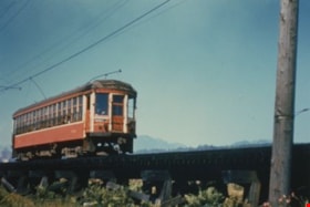
Burnaby Lake Tram #1232
https://search.heritageburnaby.ca/link/archivedescription35997
- Repository
- City of Burnaby Archives
- Date
- August 1951
- Collection/Fonds
- Burnaby Historical Society fonds
- Description Level
- Item
- Physical Description
- 1 photograph : col. ; 10 x 15 cm print
- Scope and Content
- Photograph of Tram #1232 on the Burnaby Lake Interurban line, near Still Creek.
- Repository
- City of Burnaby Archives
- Date
- August 1951
- Collection/Fonds
- Burnaby Historical Society fonds
- Subseries
- Geoff Meugans subseries
- Physical Description
- 1 photograph : col. ; 10 x 15 cm print
- Description Level
- Item
- Record No.
- 208-008
- Access Restriction
- No restrictions
- Reproduction Restriction
- Reproduce for fair dealing purposes only
- Accession Number
- BHS1988-08
- Scope and Content
- Photograph of Tram #1232 on the Burnaby Lake Interurban line, near Still Creek.
- Subjects
- Transportation - Electric Railroads
- Media Type
- Photograph
- Notes
- Title based on contents of photograph
- Historic Neighbourhood
- Burnaby Lake (Historic Neighbourhood)
- Planning Study Area
- Ardingley-Sprott Area
- Douglas-Gilpin Area
Images


The Benedictines of Westminster Priory
https://search.heritageburnaby.ca/link/archivedescription38167
- Repository
- City of Burnaby Archives
- Date
- 1951 (date of original), copied 1991
- Collection/Fonds
- Burnaby Historical Society fonds
- Description Level
- Item
- Physical Description
- 1 photograph : b&w ; 3.3 x 5.3 cm print on contact sheet 20.1 x 26.3 cm
- Scope and Content
- Photograph of an original photographic postcard of the Benedictines of Westminster Priory at Ceperley House which was funded by the Catholic Diocese beginning in 1939. There is a postmark from Merritt, British Columbia, at the top right corner.
- Repository
- City of Burnaby Archives
- Date
- 1951 (date of original), copied 1991
- Collection/Fonds
- Burnaby Historical Society fonds
- Subseries
- Burnaby Image Bank subseries
- Physical Description
- 1 photograph : b&w ; 3.3 x 5.3 cm print on contact sheet 20.1 x 26.3 cm
- Description Level
- Item
- Record No.
- 370-754
- Access Restriction
- No restrictions
- Reproduction Restriction
- No restrictions
- Accession Number
- BHS1999-03
- Scope and Content
- Photograph of an original photographic postcard of the Benedictines of Westminster Priory at Ceperley House which was funded by the Catholic Diocese beginning in 1939. There is a postmark from Merritt, British Columbia, at the top right corner.
- Subjects
- Buildings - Religious
- Buildings - Heritage
- Occupations - Clergy
- Documentary Artifacts - Postcards
- Names
- Westminster Priory
- Media Type
- Photograph
- Notes
- 1 b&w copy negative accompanying
- Negative has a pink cast
- Annotation at bottom of photograph reads, "The Benedictines of Westminster Priory, Vancouver, BC"
- Geographic Access
- Deer Lake Avenue
- Street Address
- 6344 Deer Lake Avenue
- Historic Neighbourhood
- Burnaby Lake (Historic Neighbourhood)
- Planning Study Area
- Douglas-Gilpin Area
Images

Interview with Jim and Linda Champion by Eric Damer October 21, 2012 - Track 4
https://search.heritageburnaby.ca/link/oralhistory318
- Repository
- City of Burnaby Archives
- Date Range
- 1951-1969
- Length
- 0:11:40
- Summary
- This portion of the recording pertains to Linda and Jim Champion's memories of living so close to the Oakalla Prison Farm. They also tell stories about changes to the neighbourhood, the family horse and living "a country life."
- Repository
- City of Burnaby Archives
- Summary
- This portion of the recording pertains to Linda and Jim Champion's memories of living so close to the Oakalla Prison Farm. They also tell stories about changes to the neighbourhood, the family horse and living "a country life."
- Date Range
- 1951-1969
- Length
- 0:11:40
- Names
- Oakalla Prison Farm
- Subjects
- Animals - Horses
- Historic Neighbourhood
- Central Park (Historic Neighbourhood)
- Burnaby Lake (Historic Neighbourhood)
- Interviewer
- Damer, Eric
- Interview Date
- October 21, 2012
- Scope and Content
- Recording is an interview with Jim Champion and his daughter Linda Champion conducted by Burnaby Village Museum employee Eric Damer, October 21, 2012. Major themes discussed are: raising a family in Burnaby as well as the experience of growing up in the area as it developed from farmland to suburbia.
- Biographical Notes
- Although Jim Champion was born in Burnaby in 1924, he grew up and attended school in White Rock. After serving in the navy during the war, Jim Champion came back to Vancouver, met and married Ethel (Danielson) Champion and began working for the Vancouver Fire Department. Jim and Ethel Champion's eldest daughter, Linda Champion, was born in 1948. In 1949, the Champions bought 1.8 undeveloped acres on Gilpin Street and began to build. By the time their house was built, they had become a family of six, so Jim and Ethel worked to built a larger house adjacent to the first. The Champions had chickens and a horse as their neighbourhood changed from farmland to suburbia. Jim has retired from the Vancouver Fire Department and his daughter Linda Champion is currently a City of Burnaby employee.
- Total Tracks
- 4
- Total Length
- 0:41:09
- Interviewee Name
- Champion, Jim
- Champion, Linda
- Interview Location
- Burnaby Village Museum
- Interviewer Bio
- Eric Damer is a lifelong British Columbian born in Victoria, raised in Kamloops, and currently residing in Burnaby. After studying philosophy at the University of Victoria, he became interested in the educational forces that had shaped his own life. He completed master’s and doctoral degrees in educational studies at the University of British Columbia with a particular interest in the history of adult and higher education in the province. In 2012, Eric worked for the City of Burnaby as a field researcher and writer, conducting interviews for the City Archives and Museum Oral History Program.
- Collection/Fonds
- Community Heritage Commission Special Projects fonds
- Transcript Available
- None
- Media Type
- Sound Recording
Audio Tracks
Track four of recording of interview with Jim and Linda Champion
Track four of recording of interview with Jim and Linda Champion
https://search.heritageburnaby.ca/media/hpo/_Data/_Archives_Oral_Histories/_Unrestricted/MSS171-007/MSS171-007_Track_4.mp3
Edie, Frances and Maureen Fleming
https://search.heritageburnaby.ca/link/museumdescription5156
- Repository
- Burnaby Village Museum
- Date
- 1951
- Collection/Fonds
- Waplington family fonds
- Description Level
- Item
- Physical Description
- 1 photograph : b&w ; 8 x 5 cm
- Scope and Content
- Photograph of Edith (Edie), Frances and Maureen Fleming standing together outside the Waplington/Fleming home at 3813 Deer Lake Avenue.
- Repository
- Burnaby Village Museum
- Collection/Fonds
- Waplington family fonds
- Description Level
- Item
- Physical Description
- 1 photograph : b&w ; 8 x 5 cm
- Scope and Content
- Photograph of Edith (Edie), Frances and Maureen Fleming standing together outside the Waplington/Fleming home at 3813 Deer Lake Avenue.
- Names
- Clayton, Sara Maureen Fleming
- Ehlers, Edith "Edie" Fleming
- Fleming, Frances "Fanny" Waplington
- Geographic Access
- Deer Lake Avenue
- Street Address
- 3813 Deer Lake Avenue
- Accession Code
- BV016.46.111
- Access Restriction
- No restrictions
- Reproduction Restriction
- No known restrictions
- Date
- 1951
- Media Type
- Photograph
- Historic Neighbourhood
- Burnaby Lake (Historic Neighbourhood)
- Planning Study Area
- Morley-Buckingham Area
- Scan Resolution
- 600
- Scan Date
- 13-Aug-2018
- Notes
- Title based on information from photograph album
- Note in black ink on verso of photograph reads: "Edie_Fran_Moe / 1951 / at Deer Lake Ave."
- Photograph is part of Photograph album BV016.46.52
Images
![Dredge for clearing channel through Burnaby Lake, March 1951 (date of original), copied [1985] thumbnail](/media/hpo/_Data/_BVM_Images/1985/1985_0457_0004_001.jpg?width=280)
Dredge for clearing channel through Burnaby Lake
https://search.heritageburnaby.ca/link/museumdescription10585
- Repository
- Burnaby Village Museum
- Date
- March 1951 (date of original), copied [1985]
- Collection/Fonds
- Burnaby Village Museum Photograph collection
- Description Level
- Item
- Physical Description
- 1 photograph : b&w copy negative ; 10 x 12.5 cm
- Scope and Content
- Photograph of dredge for clearing channel through Burnaby Lake, March 1951.
- Repository
- Burnaby Village Museum
- Collection/Fonds
- Burnaby Village Museum Photograph collection
- Description Level
- Item
- Physical Description
- 1 photograph : b&w copy negative ; 10 x 12.5 cm
- Scope and Content
- Photograph of dredge for clearing channel through Burnaby Lake, March 1951.
- Accession Code
- BV985.457.4
- Access Restriction
- No restrictions
- Reproduction Restriction
- May be restricted by third party rights
- Date
- March 1951 (date of original), copied [1985]
- Media Type
- Photograph
- Historic Neighbourhood
- Burnaby Lake (Historic Neighbourhood)
- Planning Study Area
- Burnaby Lake Area
- Scan Resolution
- 1200
- Scan Date
- 2022-06-07
- Photographer
- Lindsay, Jack
- Notes
- Title based on contents of photograph
Images
![Dredge for clearing channel through Burnaby Lake, March 1951 (date of original), copied [1985] thumbnail](/media/hpo/_Data/_BVM_Images/1985/1985_0457_0004_001.jpg)
![View from dredge, 1951 (date of original), copied [1985] thumbnail](/media/hpo/_Data/_BVM_Images/1985/1985_0457_0005_001.jpg?width=280)
View from dredge
https://search.heritageburnaby.ca/link/museumdescription10586
- Repository
- Burnaby Village Museum
- Date
- 1951 (date of original), copied [1985]
- Collection/Fonds
- Burnaby Village Museum Photograph collection
- Description Level
- Item
- Physical Description
- 1 photograph : b&w copy negative ; 10 x 12.5 cm
- Scope and Content
- Photograph of dredge for clearing channel through Burnaby Lake, March 1951. The surface of the lake is covered with lily pads.
- Repository
- Burnaby Village Museum
- Collection/Fonds
- Burnaby Village Museum Photograph collection
- Description Level
- Item
- Physical Description
- 1 photograph : b&w copy negative ; 10 x 12.5 cm
- Scope and Content
- Photograph of dredge for clearing channel through Burnaby Lake, March 1951. The surface of the lake is covered with lily pads.
- Accession Code
- BV985.457.5
- Access Restriction
- No restrictions
- Reproduction Restriction
- May be restricted by third party rights
- Date
- 1951 (date of original), copied [1985]
- Media Type
- Photograph
- Historic Neighbourhood
- Burnaby Lake (Historic Neighbourhood)
- Planning Study Area
- Burnaby Lake Area
- Scan Resolution
- 1200
- Scan Date
- 2022-06-07
- Photographer
- Lindsay, Jack
- Notes
- Title based on contents of photograph
Images
![View from dredge, 1951 (date of original), copied [1985] thumbnail](/media/hpo/_Data/_BVM_Images/1985/1985_0457_0005_001.jpg)