Narrow Results By
Subject
- Agriculture - Fruit and Berries 1
- Clothing - Costumes 1
- Geographic Features - Forests 1
- Occupations - Farmers 1
- Officials - Mayors and Reeves 1
- Symbols - Flags 1
- Transportation - Carts 1
- Transportation - Electric Railroads 8
- Transportation - Horses 1
- Transportation - Public Transit 1
- Transportation - Wagons 1

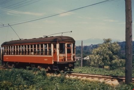
Burnaby Lake Tram #1227
https://search.heritageburnaby.ca/link/archivedescription35998
- Repository
- City of Burnaby Archives
- Date
- June 1952
- Collection/Fonds
- Burnaby Historical Society fonds
- Description Level
- Item
- Physical Description
- 1 photograph : col. ; 10 x 15 cm print
- Scope and Content
- Photograph of Tram #1227 on the Burnaby Lake Interurban line, near Murrin station.
- Repository
- City of Burnaby Archives
- Date
- June 1952
- Collection/Fonds
- Burnaby Historical Society fonds
- Subseries
- Geoff Meugans subseries
- Physical Description
- 1 photograph : col. ; 10 x 15 cm print
- Description Level
- Item
- Record No.
- 208-009
- Access Restriction
- No restrictions
- Reproduction Restriction
- Reproduce for fair dealing purposes only
- Accession Number
- BHS1988-08
- Scope and Content
- Photograph of Tram #1227 on the Burnaby Lake Interurban line, near Murrin station.
- Subjects
- Transportation - Electric Railroads
- Media Type
- Photograph
- Notes
- Title based on contents of photograph
- Geographic Access
- Burnaby Lake Interurban line
- Historic Neighbourhood
- Burnaby Lake (Historic Neighbourhood)
- Planning Study Area
- Dawson-Delta Area
- Douglas-Gilpin Area
Images
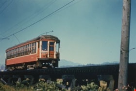
Burnaby Lake Tram #1232
https://search.heritageburnaby.ca/link/archivedescription35997
- Repository
- City of Burnaby Archives
- Date
- August 1951
- Collection/Fonds
- Burnaby Historical Society fonds
- Description Level
- Item
- Physical Description
- 1 photograph : col. ; 10 x 15 cm print
- Scope and Content
- Photograph of Tram #1232 on the Burnaby Lake Interurban line, near Still Creek.
- Repository
- City of Burnaby Archives
- Date
- August 1951
- Collection/Fonds
- Burnaby Historical Society fonds
- Subseries
- Geoff Meugans subseries
- Physical Description
- 1 photograph : col. ; 10 x 15 cm print
- Description Level
- Item
- Record No.
- 208-008
- Access Restriction
- No restrictions
- Reproduction Restriction
- Reproduce for fair dealing purposes only
- Accession Number
- BHS1988-08
- Scope and Content
- Photograph of Tram #1232 on the Burnaby Lake Interurban line, near Still Creek.
- Subjects
- Transportation - Electric Railroads
- Media Type
- Photograph
- Notes
- Title based on contents of photograph
- Historic Neighbourhood
- Burnaby Lake (Historic Neighbourhood)
- Planning Study Area
- Ardingley-Sprott Area
- Douglas-Gilpin Area
Images

![Douglas Road Interurban station, [1920 or 1921] thumbnail](/media/hpo/_Data/_BVM_Images/1985/1985_0031_0005_001.jpg?width=280)
Douglas Road Interurban station
https://search.heritageburnaby.ca/link/museumdescription164
- Repository
- Burnaby Village Museum
- Date
- [1920 or 1921]
- Collection/Fonds
- Burnaby Village Museum Photograph collection
- Description Level
- Item
- Physical Description
- 1 photograph : sepia ; 7.1 x 11.5 cm
- Scope and Content
- Photograph of Pearl Cowan and her son, Walter sitting on a bench at Douglas Road Interurban Station. The back of the bench appears to be used as an advertisement space and the waiting area is made of wood plank board, with tall weeds and grass growing around the station.
- Repository
- Burnaby Village Museum
- Collection/Fonds
- Burnaby Village Museum Photograph collection
- Description Level
- Item
- Physical Description
- 1 photograph : sepia ; 7.1 x 11.5 cm
- Scope and Content
- Photograph of Pearl Cowan and her son, Walter sitting on a bench at Douglas Road Interurban Station. The back of the bench appears to be used as an advertisement space and the waiting area is made of wood plank board, with tall weeds and grass growing around the station.
- History
- Margaret Pearl Naismith (1887-1970) married Alexander "Allie" MacPherson Cowan (1881-1963) in 1910 in Kamloops BC. Alexander was the son of Walter Scott Cowan (1843-1930) and Annie McPherson (1859-1935), who lived in Burnaby on Douglas Road. Pearl and Allie had three children from their family home at Spruce and Fitzgerald where they lived from 1918 to 1922: Amy, Clara, Thomas Walter Cowan (1918-?) who is seated on his mother's lap in this photo.
- Subjects
- Transportation - Electric Railroads
- Geographic Access
- Burnaby Lake Interurban line
- Accession Code
- BV985.31.5
- Access Restriction
- No restrictions
- Reproduction Restriction
- No known restrictions
- Date
- [1920 or 1921]
- Media Type
- Photograph
- Historic Neighbourhood
- Burnaby Lake (Historic Neighbourhood)
- Planning Study Area
- Ardingley-Sprott Area
- Scan Resolution
- 600
- Scan Date
- 2023-12-19
- Notes
- Title based on contents of photograph
- Note in pencil on verso of photograph reads: "Douglas Road Station c. 1920/21 / Shown are Pearl Cowan and son Walter Cowan. They lived [at] Spruce & Fitzgerald c. 1918-1922."
Images
![Douglas Road Interurban station, [1920 or 1921] thumbnail](/media/hpo/_Data/_BVM_Images/1985/1985_0031_0005_001.jpg)
![First Burnaby Lake tram through Burnaby Deer Lake station, [1911] thumbnail](/media/hpo/_Data/_Archives_Images/_Unrestricted/477/477-170.jpg?width=280)
First Burnaby Lake tram through Burnaby Deer Lake station
https://search.heritageburnaby.ca/link/archivedescription38851
- Repository
- City of Burnaby Archives
- Date
- [1911]
- Collection/Fonds
- Peers Family and Hill Family fonds
- Description Level
- Item
- Physical Description
- 1 photograph : sepia ; 5.7 x 8 cm
- Scope and Content
- Photograph of the first Interurban tram going though the Deer Lake station in the Burnaby Lake area.
- Repository
- City of Burnaby Archives
- Date
- [1911]
- Collection/Fonds
- Peers Family and Hill Family fonds
- Physical Description
- 1 photograph : sepia ; 5.7 x 8 cm
- Description Level
- Item
- Record No.
- 477-170
- Access Restriction
- No restrictions
- Reproduction Restriction
- No known restrictions
- Accession Number
- 2007-12
- Scope and Content
- Photograph of the first Interurban tram going though the Deer Lake station in the Burnaby Lake area.
- Media Type
- Photograph
- Notes
- Title based on caption accompanying photograph
- Geographic Access
- Burnaby Lake Interurban line
- Historic Neighbourhood
- Burnaby Lake (Historic Neighbourhood)
- Planning Study Area
- Burnaby Lake Area
Images
![First Burnaby Lake tram through Burnaby Deer Lake station, [1911] thumbnail](/media/hpo/_Data/_Archives_Images/_Unrestricted/477/477-170.jpg)

Interurban 1223 Volunteers Feb. 26, 2005
https://search.heritageburnaby.ca/link/archivedescription98462
- Repository
- City of Burnaby Archives
- Date
- February 26, 2005
- Collection/Fonds
- Burnaby Historical Society fonds
- Description Level
- File
- Physical Description
- 14 photographs (jpgs) on 1 optical disc
- Scope and Content
- File contains photographs of volunteers working on the restoration of interurban tram 1223.
- Repository
- City of Burnaby Archives
- Date
- February 26, 2005
- Collection/Fonds
- Burnaby Historical Society fonds
- Series
- Administration series
- Physical Description
- 14 photographs (jpgs) on 1 optical disc
- Description Level
- File
- Record No.
- 633-016
- Access Restriction
- No restrictions
- Reproduction Restriction
- No restrictions
- Accession Number
- 2020-06
- Scope and Content
- File contains photographs of volunteers working on the restoration of interurban tram 1223.
- Subjects
- Transportation - Electric Railroads
- Media Type
- Photograph
- Notes
- Transcribed title
- Title transcribed from optical disc label
- Street Address
- 6501 Deer Lake Avenue
- Historic Neighbourhood
- Burnaby Lake (Historic Neighbourhood)
- Planning Study Area
- Morley-Buckingham Area
Images
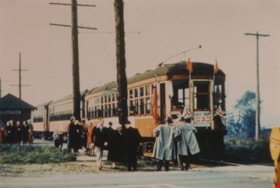
Last trip of the Burnaby Lake Interurban line
https://search.heritageburnaby.ca/link/archivedescription36001
- Repository
- City of Burnaby Archives
- Date
- October 1953
- Collection/Fonds
- Burnaby Historical Society fonds
- Description Level
- Item
- Physical Description
- 1 photograph : col. ; 10 x 15 cm print
- Scope and Content
- Photograph of the last trip for Tram no.1231 (and two others) on the Burnaby Lake Interurban line, as they arrive at Douglas Road station.
- Repository
- City of Burnaby Archives
- Date
- October 1953
- Collection/Fonds
- Burnaby Historical Society fonds
- Subseries
- Geoff Meugans subseries
- Physical Description
- 1 photograph : col. ; 10 x 15 cm print
- Description Level
- Item
- Record No.
- 208-012
- Access Restriction
- No restrictions
- Reproduction Restriction
- Reproduce for fair dealing purposes only
- Accession Number
- BHS1988-08
- Scope and Content
- Photograph of the last trip for Tram no.1231 (and two others) on the Burnaby Lake Interurban line, as they arrive at Douglas Road station.
- Subjects
- Transportation - Electric Railroads
- Media Type
- Photograph
- Notes
- Title based on contents of photograph
- Geographic Access
- Burnaby Lake Interurban line
- Historic Neighbourhood
- Burnaby Lake (Historic Neighbourhood)
- Planning Study Area
- Ardingley-Sprott Area
Images

![Last trip of the Burnaby Lake Interurban line, October 1953 (date of original), copied [2000] thumbnail](/media/hpo/_Data/_Archives_Images/_Unrestricted/371/431-001.jpg?width=280)
Last trip of the Burnaby Lake Interurban line
https://search.heritageburnaby.ca/link/archivedescription38412
- Repository
- City of Burnaby Archives
- Date
- October 1953 (date of original), copied [2000]
- Collection/Fonds
- Burnaby Historical Society fonds
- Description Level
- Item
- Physical Description
- 1 photograph : b&w ; 21 x 25 cm print
- Scope and Content
- Photograph of Marnie Currie and Grant Washington standing in front of the Burnaby Lake Interurban car dressed in period costume. The photograph was taken at Douglas Road station just prior to the tram's last run through Burnaby. A sign attached to the car reads: "Last trip, good-bye trams, Pupils o…
- Repository
- City of Burnaby Archives
- Date
- October 1953 (date of original), copied [2000]
- Collection/Fonds
- Burnaby Historical Society fonds
- Subseries
- Photographs subseries
- Physical Description
- 1 photograph : b&w ; 21 x 25 cm print
- Description Level
- Item
- Record No.
- 431-001
- Access Restriction
- No restrictions
- Reproduction Restriction
- Reproduce for fair dealing purposes only
- Accession Number
- BHS2007-04
- Scope and Content
- Photograph of Marnie Currie and Grant Washington standing in front of the Burnaby Lake Interurban car dressed in period costume. The photograph was taken at Douglas Road station just prior to the tram's last run through Burnaby. A sign attached to the car reads: "Last trip, good-bye trams, Pupils of Douglas School, Burnaby."
- Media Type
- Photograph
- Notes
- Title based on contents of photograph
- Geographic Access
- Burnaby Lake Interurban line
- Historic Neighbourhood
- Burnaby Lake (Historic Neighbourhood)
- Planning Study Area
- Ardingley-Sprott Area
Images
![Last trip of the Burnaby Lake Interurban line, October 1953 (date of original), copied [2000] thumbnail](/media/hpo/_Data/_Archives_Images/_Unrestricted/371/431-001.jpg)

Loading Strawberries, BCERy, Douglas Road, Burnaby BC
https://search.heritageburnaby.ca/link/archivedescription66211
- Repository
- City of Burnaby Archives
- Date
- 1894
- Collection/Fonds
- Peers Family and Hill Family fonds
- Description Level
- Item
- Physical Description
- 1 photograph : b&w ; 13 x 18 cm on cardboard 22 x 27.5 cm
- Scope and Content
- Photograph of a group of farmers loading their crates onto a railway car. Identified (left to right), Bernard R. Hill, Louis Claude Hill, Charles Frederick Sprott, George E. Clayton, and Louis "Edgar" Sprott, who are loading up their strawberries on a street car. The farmers are lined up in a row,…
- Repository
- City of Burnaby Archives
- Date
- 1894
- Collection/Fonds
- Peers Family and Hill Family fonds
- Physical Description
- 1 photograph : b&w ; 13 x 18 cm on cardboard 22 x 27.5 cm
- Description Level
- Item
- Record No.
- 477-938
- Access Restriction
- No restrictions
- Reproduction Restriction
- No known restrictions
- Accession Number
- 2007-12
- Scope and Content
- Photograph of a group of farmers loading their crates onto a railway car. Identified (left to right), Bernard R. Hill, Louis Claude Hill, Charles Frederick Sprott, George E. Clayton, and Louis "Edgar" Sprott, who are loading up their strawberries on a street car. The farmers are lined up in a row, each sitting in their own horse and cart as they bring their strawberries to the station.
- Subjects
- Agriculture - Fruit and Berries
- Transportation - Electric Railroads
- Transportation - Horses
- Transportation - Carts
- Occupations - Farmers
- Transportation - Wagons
- Officials - Mayors and Reeves
- Names
- British Columbia Electric Railway Company
- Hill, Louis Claude "Claude"
- Hill, Bernard R.
- Every-Clayton, George
- Sprott, Louis "Edgar"
- Sprott, Charles Frederick
- Media Type
- Photograph
- Notes
- Title based on contents of photograph
- Caption on recto of photograph reads: "Loading Strawberries, B.C.E.Ry., Douglas Rd., Burnaby, B.C."
- Geographic Access
- Douglas Road
- Historic Neighbourhood
- Burnaby Lake (Historic Neighbourhood)
Images

![Survey and Subdivision plans in New Westminster District Group 1 – Burnaby
, [1908] thumbnail](/media/hpo/_Data/_BVM_Cartographic_Material/1977/1977_0093_0004a_001.jpg?width=280)
Survey and Subdivision plans in New Westminster District Group 1 – Burnaby
https://search.heritageburnaby.ca/link/museumdescription6973
- Repository
- Burnaby Village Museum
- Date
- [1908]
- Collection/Fonds
- Burnaby Village Museum Map collection
- Description Level
- File
- Physical Description
- 10 plans : blueprint ink on paper mounted on 2 sides of cardboard ; 76 cm x 102 cm
- Scope and Content
- Item consists of a large board of four New Westminster District Gp 1 - subdivision plans mounted on one side and six New Westminster District Gp 1 - subdivision plans mounted on the other side. Side A: 1. Blueprint "Plan / of - ReSubdivision / of / Lots 1-18 inclusive / Blocks 20 and 21 / in Sub…
- Repository
- Burnaby Village Museum
- Collection/Fonds
- Burnaby Village Museum Map collection
- Description Level
- File
- Physical Description
- 10 plans : blueprint ink on paper mounted on 2 sides of cardboard ; 76 cm x 102 cm
- Material Details
- Scales [between 1:792 and 1:4752]
- Index number on edge of board reads: "4"
- Scope and Content
- Item consists of a large board of four New Westminster District Gp 1 - subdivision plans mounted on one side and six New Westminster District Gp 1 - subdivision plans mounted on the other side. Side A: 1. Blueprint "Plan / of - ReSubdivision / of / Lots 1-18 inclusive / Blocks 20 and 21 / in Subdivision / of / Lot 53 -Gr.1 / New Westminster District" / "Subdivision Lot Numbers - Shown in Red". Plan is bordered by First Street / Jorgenson's Line / Fourth Avenue and Second Street with Fifith Avenue running through the centre. There is an index in the upper right corner of the plan. Planned is signed by "Peter Byrne" and "William R. Phillips" and dated July 28, 1908. (Geographic location: Burnaby) 2. Blueprint "Plan / of Subdivision / of / Lot 159 / and a Portion of Lot 158 / Group One / New Westminster District". Plan is bordered by Lots 96 and 97; South Wilson Street; North Arm Road and Lot 160 / Power House Road (Lot 155 A). B.C.E.R. Gilley Station is identified in the upper right corner of the plan. (Geographic location: Burnaby) 3. Blueprint plan identified as "Subdvs 10, L 88 and Lot 25, G. 1" Plan identifies Cumberland Street running from top to the bottom and a Ravine running alongside with the Jensen house, stable and barn. (Geographic location: Burnaby) 4. Blueprint Plan of "Lot 153. G. 1 /New Westminster District". Plan identifies the "New Westminster & Vancouver Tramway" and the "New Westminster and Vancouver Road" running through the plan of Lot 53. (Geographic location: Burnaby) Side B: 1. Blueprint plan of "Profile on Proposed North Rd. Diversion". 2. Blueprint plan (no title) showing wood lots north of Burnaby Lake and Brunette River and west of North Road. Various lots are identified as "Heavily Timbered" (Lot 57); "Splendid Fir and Cedar / Heavy Fir etc. / Fine Cedar" (Lots 143, 148); "Rough Light Timber," (Lot 56); "Some Fir and Cedar" (Lot 40). (Geographic location: Burnaby) 3. Blueprint "Plan / of Subdivision / of a Portion / of Lot 87, Gr.1 / New Westminster District". Plan is bordered by Burnaby Lake at the top and Hastings Road / Lot 86 at the bottom and Lot 90 to the east. "Albert J. Hill B.C.LotS." Annotation in ink reads: " J.A. Brownlee, B.C.L.S. / Subdivision / Map 1494 / Bd. 248". Plan is signed by "Peter Byrne, Reeve" (Geographic location: Burnaby) 4. Blueprint plan of Subdivisions along either side of Douglas Road including Lots 117; 119; 74; 80; 79 and 77. (Geographic location: Burnaby) 5. Blueprint "Plan / of / Subdivision of / Lot 27 / in Subdivision / of / Lot 30 / Group One / New Westminster District" Plan is bordered by Lot 26, Lot 28 and Hastings Rd. Lot 27 runs north of Edmonds Street. , "Albert J. Hill, B.C.LotS." (Geographic location: Burnaby) 6. Blueprint plan identified as a "Cultivated Orchard" including the names "W. Grace" and "G. Mead" located north of the North Arm Fraser River and west of "Twentieth Street_ City Boundary". Handwritten annotation in coloured pencil reads: "Portion of Lot 172" (Geographic location: Burnaby)
- Subjects
- Geographic Features - Forests
- Geographic Access
- Cumberland Street
- North Road
- Hastings Street
- Douglas Road
- Accession Code
- HV977.93.4
- Access Restriction
- No restrictions
- Reproduction Restriction
- No known restrictions
- Date
- [1908]
- Media Type
- Cartographic Material
- Historic Neighbourhood
- Burnaby Lake (Historic Neighbourhood)
- Fraser Arm (Historic Neighbourhood)
- Planning Study Area
- Douglas-Gilpin Area
- Burnaby Lake Area
- Scan Resolution
- 300
- Scale
- 72
- Notes
- Title based on contents of file
- Scale is measured in chains. (One chain equals 792 inches)
- The term "Lot" can also refer to a "District Lot”-
Images
![Survey and Subdivision plans in New Westminster District Group 1 – Burnaby
, [1908] thumbnail](/media/hpo/_Data/_BVM_Cartographic_Material/1977/1977_0093_0004a_001.jpg)
