Narrow Results By
Subject
- Advertising Medium - Signs and Signboards 1
- Agriculture - Farms 23
- Agriculture - Poultry 1
- Animals - Birds 1
- Animals - Dogs 2
- Animals - Horses 5
- Animals - Poultry 1
- Buildings 1
- Buildings - Agricultural - Barns 6
- Buildings - Agricultural - Greenhouses 2
- Buildings - Civic 1
- Buildings - Civic - City Halls 17

Burnaby Lake Neighbourhood
https://search.heritageburnaby.ca/link/landmark700
- Repository
- Burnaby Heritage Planning
- Associated Dates
- 1925-1954
- Heritage Value
- After World War I and the Great Depression of the 1930s, more homes were constructed and subdivisions created in the Burnaby Lake district. The area around Deer Lake gained a reputation for being an "artistic development of commodious homes with park-like grounds."
- Historic Neighbourhood
- Burnaby Lake (Historic Neighbourhood)
- Planning Study Area
- Burnaby Lake Area
Images


Ardingley-Sprott Neighbourhood
https://search.heritageburnaby.ca/link/landmark797
- Repository
- Burnaby Heritage Planning
- Associated Dates
- 1955-2008
- Heritage Value
- The Ardingley-Sprott Neighbourhood is primarily non-residential and developed in the 1970s west of the Burnaby Lake park area. It grew to include a large recreational component in the form of the Burnaby Lake Sports Complex and playing fields.
- Historic Neighbourhood
- Burnaby Lake (Historic Neighbourhood)
- Planning Study Area
- Ardingley-Sprott Area
Images


Douglas-Gilpin Neighbourhood
https://search.heritageburnaby.ca/link/landmark799
- Repository
- Burnaby Heritage Planning
- Associated Dates
- 1955-2008
- Heritage Value
- The Douglas-Gilpin Neighbourhood developed into a diverse area incorporating residential, business, educational and park districts in the period after 1955. The BCIT site was built in the early 1960s, shortly after the Burnaby Municipal Hall was located on Canada Way near Deer Lake in 1956. The construction of the Municipal Hall at this location fostered the creation of an administrative and business centre adjacent to the park, while the northern and central areas of the neighbourhood retained their primarily residential character.
- Historic Neighbourhood
- Burnaby Lake (Historic Neighbourhood)
- Planning Study Area
- Douglas-Gilpin Area
Images


Burnaby Municipal Hall
https://search.heritageburnaby.ca/link/landmark807
- Repository
- Burnaby Heritage Planning
- Geographic Access
- Canada Way
- Associated Dates
- 1956
- Heritage Value
- When staff outgrew the municipal buildings at Edmonds and Kingsway, a debate erupted over where to build a new municipal hall. North Burnaby residents argued against the Kingsway and Edmonds site as it was too removed for their needs, but South Burnaby residents were not prepared to accept a hall in North Burnaby. The debate was finally resolved when it was suggested that the new civic centre for the municipality be in the exact geographic centre of Burnaby. Fortunately, this meant that the new hall was to be built near Deer Lake, in the beautiful Central Valley setting. Burnaby voters accepted this decision and approved the $625,000.00 it would take to build the new structure and the official opening ceremony was held June 22, 1956 when then Reeve Charles MacSorley received the keys to the hall from the contractor.
- Historic Neighbourhood
- Burnaby Lake (Historic Neighbourhood)
- Planning Study Area
- Douglas-Gilpin Area
- Street Address
- 4949 Canada Way
- Street View URL
- Google Maps Street View
Images


Burnaby Central School
https://search.heritageburnaby.ca/link/landmark814
- Repository
- Burnaby Heritage Planning
- Geographic Access
- Canada Way
- Associated Dates
- 1958
- Heritage Value
- Burnaby Central School became the third high school to be built in Burnaby (following Burnaby North and Burnaby South). The increased school enrolments due to the rapidly growing population in Burnaby meant that the School District required this third high school to be placed between the other two. In its first year, 719 students attended Burnaby Central.
- Historic Neighbourhood
- Burnaby Lake (Historic Neighbourhood)
- Planning Study Area
- Douglas-Gilpin Area
- Street Address
- 4939 Canada Way
- Street View URL
- Google Maps Street View
Images


Burnaby Winter Club
https://search.heritageburnaby.ca/link/landmark816
- Repository
- Burnaby Heritage Planning
- Geographic Access
- Canada Way
- Associated Dates
- 1956
- Heritage Value
- Skating on Deer Lake and Burnaby Lake was the inspiration to form the Burnaby Winter Club in the 1950s. In 1958, the volunteer group opened an indoor ice facility, still operating today at 4990 Canada Way. Originally, the facility boasted 8 sheets of curling ice, that were used to capacity by the more than 500 family and individual members in the heyday of the Club. The Winter Club was a social centre: in addition to curling, it was a popular place for banquets and dances, and a place for families to spend time together. In the 1960s, the eight sheets of curling ice were reduced to five, to make room for a sheet of hockey ice for the members’ children. Volunteer coaches were committed to excellence, and the Club produced many professional hockey players. By 1964, the Club’s first future NHL player was playing: Pee Wee player Jack McIlhargey.
- Historic Neighbourhood
- Burnaby Lake (Historic Neighbourhood)
- Planning Study Area
- Douglas-Gilpin Area
- Street Address
- 4990 Canada Way
- Street View URL
- Google Maps Street View
Images


Burnaby Lake Neighbourhood
https://search.heritageburnaby.ca/link/landmark821
- Repository
- Burnaby Heritage Planning
- Associated Dates
- 1955-2008
- Heritage Value
- In 1966 Burnaby Lake was identified as a key potential regional park in the GVRD ’s Regional Park Plan for the Lower Mainland. The lake was to be developed for nature study, strolling, trail riding, canoeing, sightseeing and picnicking. It was formally recognized as a regional nature park in 1979, at which time the GVRD assumed management of the park through a lease agreement with the City of Burnaby. In 1993 Burnaby Lake was selected by the City of Burnaby to be included in Greater Vancouver ’s Green Zone, and was identified as a key component of the GVRD ’s Park and Outdoor Recreation System (PORS) for the Burrard/Peninsula/Richmond sector, which includes Burnaby, Vancouver, New Westminster, and Richmond.
- Historic Neighbourhood
- Burnaby Lake (Historic Neighbourhood)
- Planning Study Area
- Burnaby Lake Area
Images


Morley-Buckingham Neighbourhood
https://search.heritageburnaby.ca/link/landmark829
- Repository
- Burnaby Heritage Planning
- Associated Dates
- 1955-2008
- Heritage Value
- In the 1980 "Residential Neighbourhood Environment Study," the Morley-Buckingham Neighbourhood is described as "perhaps Burnaby's most prestigious residential area. The lots are larger than most other areas of the Municipality and this, along with the new expensive housing developed over the past 10 years, has created a very desirable residential neighbourhood...The older area of Buckingham lies at the lower edge of the slope and here the homes and streets are more uniform and aged between 20 and 25 years old...to the east of Canada Way lies...a cluster townhouse development."
- Historic Neighbourhood
- Burnaby Lake (Historic Neighbourhood)
- Planning Study Area
- Morley-Buckingham Area
Images


Lakeview Elementary School
https://search.heritageburnaby.ca/link/landmark834
- Repository
- Burnaby Heritage Planning
- Geographic Access
- Mayfield Street
- Associated Dates
- 1958
- Heritage Value
- The Burnaby School Inspector's report of 1955 estimated that by 1960, the total enrolment in Burnaby would go up by over 8000 pupils. As a result, new schools needed to be built to manage this increase, Lakeview being only one of many. Lakeview opened in 1958 with 193 students. Additions to the school were made in 1965 and 1969.
- Historic Neighbourhood
- Burnaby Lake (Historic Neighbourhood)
- Planning Study Area
- Lakeview-Mayfield Area
- Street Address
- 7777 Mayfield Street
- Street View URL
- Google Maps Street View
Images


Morley Elementary School
https://search.heritageburnaby.ca/link/landmark835
- Repository
- Burnaby Heritage Planning
- Geographic Access
- Morley Street
- Associated Dates
- 1955
- Heritage Value
- In 1955 Morley Elementary School opened with 292 pupils, an indication of how quickly the residential areas around the Morley area were growing in the post-war period. Similar to other elementary schools built in Burnaby at the time, Morley was constructed on one level with classrooms in a line that could be added to as the need arose. Additions were made to the school in 1956, 1960 and 1969.
- Historic Neighbourhood
- Burnaby Lake (Historic Neighbourhood)
- Planning Study Area
- Morley-Buckingham Area
- Street Address
- 7355 Morley Street
- Street View URL
- Google Maps Street View
Images

Princess Margaret's visit
https://search.heritageburnaby.ca/link/archivedescription86329
- Repository
- City of Burnaby Archives
- Date
- June 1958
- Collection/Fonds
- Richard Hardy family fonds
- Description Level
- Item
- Physical Description
- 1 photograph : b&w negative ; 4 x 5.5 cm
- Scope and Content
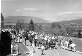
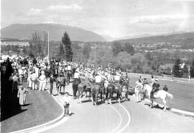
- Photograph of a crowd gathering for Princess Margaret's visit to Burnaby in June of 1958. The photograph is taken outside the municipal hall located on Grandview Highway ( later, Canada Way) which can be seen on the left. There are several people gathered on the road along with people riding horses…
- Repository
- City of Burnaby Archives
- Date
- June 1958
- Collection/Fonds
- Richard Hardy family fonds
- Physical Description
- 1 photograph : b&w negative ; 4 x 5.5 cm
- Description Level
- Item
- Record No.
- 570-008
- Access Restriction
- No restrictions
- Reproduction Restriction
- Reproduce for fair dealing purposes only
- Accession Number
- 2014-16
- Scope and Content
- Photograph of a crowd gathering for Princess Margaret's visit to Burnaby in June of 1958. The photograph is taken outside the municipal hall located on Grandview Highway ( later, Canada Way) which can be seen on the left. There are several people gathered on the road along with people riding horses. The north shore mountains can be seen in the distance.
- Subjects
- Ceremonies
- Media Type
- Photograph
- Notes
- Title based on contents of photograph
- 1 photograph : b&w ; 9 x 13 cm accompanying
- Geographic Access
- Grandview Highway
- Canada Way
- Street Address
- 4949 Canada Way
- Historic Neighbourhood
- Burnaby Lake (Historic Neighbourhood)
Images

Princess Margaret's visit
https://search.heritageburnaby.ca/link/archivedescription86438
- Repository
- City of Burnaby Archives
- Date
- June 1958
- Collection/Fonds
- Richard Hardy family fonds
- Description Level
- Item
- Physical Description
- 1 photograph : b&w negative ; 5.5 x 4 cm
- Scope and Content
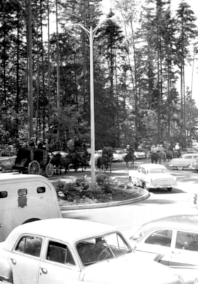
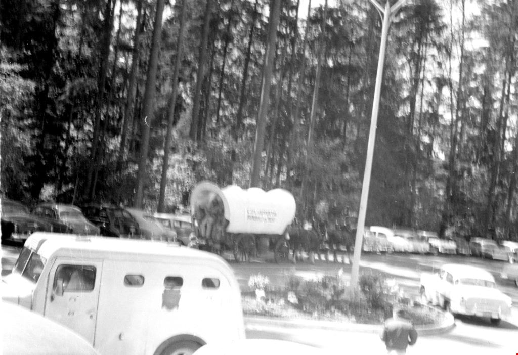
- Photograph of a automobiles, horses and a horse drawn carriage gathering for Princess Margaret's visit to Burnaby in June of 1958. The photograph is taken on the roads outside the municipal hall located on Grandview Highway ( later, Canada Way). Deer Lake park can be seen in the background.
- Repository
- City of Burnaby Archives
- Date
- June 1958
- Collection/Fonds
- Richard Hardy family fonds
- Physical Description
- 1 photograph : b&w negative ; 5.5 x 4 cm
- Description Level
- Item
- Record No.
- 570-009
- Access Restriction
- No restrictions
- Reproduction Restriction
- Reproduce for fair dealing purposes only
- Accession Number
- 2014-16
- Scope and Content
- Photograph of a automobiles, horses and a horse drawn carriage gathering for Princess Margaret's visit to Burnaby in June of 1958. The photograph is taken on the roads outside the municipal hall located on Grandview Highway ( later, Canada Way). Deer Lake park can be seen in the background.
- Subjects
- Ceremonies
- Media Type
- Photograph
- Notes
- Title based on contents of photograph
- 1 photograph : b&w ; 13 x 9 cm accompanying
- Geographic Access
- Grandview Highway
- Canada Way
- Street Address
- 4949 Canada Way
- Historic Neighbourhood
- Burnaby Lake (Historic Neighbourhood)
Images

Princess Margaret's visit
https://search.heritageburnaby.ca/link/archivedescription86444
- Repository
- City of Burnaby Archives
- Date
- June 1958
- Collection/Fonds
- Richard Hardy family fonds
- Description Level
- Item
- Physical Description
- 1 photograph : b&w negative ; 4 x 5.5 cm
- Scope and Content
- Photograph of a crowd gathering for Princess Margaret's visit to Burnaby in June of 1958. The photograph is taken outside the municipal hall located on Grandview Highway ( later, Canada Way). There are several people gathered on the road along with people riding horses. The north shore mountains ca…
- Repository
- City of Burnaby Archives
- Date
- June 1958
- Collection/Fonds
- Richard Hardy family fonds
- Physical Description
- 1 photograph : b&w negative ; 4 x 5.5 cm
- Description Level
- Item
- Record No.
- 570-010
- Access Restriction
- No restrictions
- Reproduction Restriction
- Reproduce for fair dealing purposes only
- Accession Number
- 2014-16
- Scope and Content
- Photograph of a crowd gathering for Princess Margaret's visit to Burnaby in June of 1958. The photograph is taken outside the municipal hall located on Grandview Highway ( later, Canada Way). There are several people gathered on the road along with people riding horses. The north shore mountains can be seen in the distance.
- Subjects
- Ceremonies
- Media Type
- Photograph
- Notes
- Title based on contents of photograph
- 1 photograph : b&w ; 9 x 13 cm accompanying
- Geographic Access
- Grandview Highway
- Canada Way
- Street Address
- 4949 Canada Way
- Historic Neighbourhood
- Burnaby Lake (Historic Neighbourhood)
Images


Princess Margaret's visit
https://search.heritageburnaby.ca/link/archivedescription86451
- Repository
- City of Burnaby Archives
- Date
- June 1958
- Collection/Fonds
- Richard Hardy family fonds
- Description Level
- Item
- Physical Description
- 1 photograph : b&w negative ; 4 x 5.5 cm
- Scope and Content
- Photograph of vehicles and a horse drawn covered wagon gathering for Princess Margaret's visit to Burnaby in June of 1958. The photograph is taken outside the municipal hall located on Grandview Highway (later, Canada Way). Deer Lake Park can be seen in the background.
- Repository
- City of Burnaby Archives
- Date
- June 1958
- Collection/Fonds
- Richard Hardy family fonds
- Physical Description
- 1 photograph : b&w negative ; 4 x 5.5 cm
- Description Level
- Item
- Record No.
- 570-011
- Access Restriction
- No restrictions
- Reproduction Restriction
- Reproduce for fair dealing purposes only
- Accession Number
- 2014-16
- Scope and Content
- Photograph of vehicles and a horse drawn covered wagon gathering for Princess Margaret's visit to Burnaby in June of 1958. The photograph is taken outside the municipal hall located on Grandview Highway (later, Canada Way). Deer Lake Park can be seen in the background.
- Subjects
- Ceremonies
- Media Type
- Photograph
- Notes
- Title based on contents of photograph
- 1 photograph : b&w ; 9 x 13 cm accompanying
- Geographic Access
- Grandview Highway
- Canada Way
- Street Address
- 4949 Canada Way
- Historic Neighbourhood
- Burnaby Lake (Historic Neighbourhood)
Images
![Chickens at Meyers, [between 1950 and 1959] thumbnail](/media/hpo/_Data/_Archives_Images/_Unrestricted/600/620-010.jpg?width=280)
Chickens at Meyers
https://search.heritageburnaby.ca/link/archivedescription91829
- Repository
- City of Burnaby Archives
- Date
- [between 1950 and 1959]
- Collection/Fonds
- Small family fonds
- Description Level
- Item
- Physical Description
- 1 photograph : b&w ; 6.5 cm x 9 cm
- Scope and Content
- Photograph of chickens feeding at the Meyers' property at 5106 Douglas Road.
- Repository
- City of Burnaby Archives
- Date
- [between 1950 and 1959]
- Collection/Fonds
- Small family fonds
- Physical Description
- 1 photograph : b&w ; 6.5 cm x 9 cm
- Description Level
- Item
- Record No.
- 620-010
- Access Restriction
- No restrictions
- Reproduction Restriction
- No reproduction permitted
- Accession Number
- 2017-01
- Scope and Content
- Photograph of chickens feeding at the Meyers' property at 5106 Douglas Road.
- Subjects
- Agriculture - Poultry
- Media Type
- Photograph
- Notes
- Transcribed title
- Title transcribed from note on verso of photograph
- 5106 Douglas Road later subdivided into 5539 and 5545 Norfolk Street.
- Note in blue ink on verso of photograph reads: "Chickens at Meyers 1950's / (Ernest and Magdalena Meyers) Residence / 5106 Douglas Rd."
- Note in blue ink on verso of photograph reads: "P.10"
- Note in blue ink on verso of photograph (struck through) reads: "E.A. Meyers Residence ./ Photo by Pat Meyers / 1976?"
- Stamp in green ink on verso of photograph reads: "734J"
- Street Address
- 5106 Douglas Road
- Historic Neighbourhood
- Burnaby Lake (Historic Neighbourhood)
- Planning Study Area
- Ardingley-Sprott Area
Images
![Chickens at Meyers, [between 1950 and 1959] thumbnail](/media/hpo/_Data/_Archives_Images/_Unrestricted/600/620-010.jpg)

Looking west from Douglas Road
https://search.heritageburnaby.ca/link/archivedescription91831
- Repository
- City of Burnaby Archives
- Date
- 1951
- Collection/Fonds
- Small family fonds
- Description Level
- Item
- Physical Description
- 1 photograph : b&w ; 12.5 cm x 9 cm
- Scope and Content
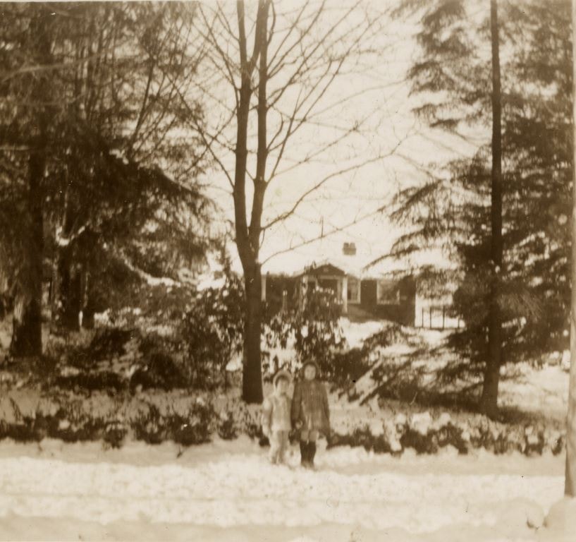
- Photograph of Kathryn and Elizabeth Small standing in front of the Roberts' house at 5118 Douglas Road. Snow covers the ground, trees, and house and the girls wear winter coats. The photograph was taken from Douglas Road, looking west.
- Repository
- City of Burnaby Archives
- Date
- 1951
- Collection/Fonds
- Small family fonds
- Physical Description
- 1 photograph : b&w ; 12.5 cm x 9 cm
- Description Level
- Item
- Record No.
- 620-012
- Access Restriction
- No restrictions
- Reproduction Restriction
- No reproduction permitted
- Accession Number
- 2017-01
- Scope and Content
- Photograph of Kathryn and Elizabeth Small standing in front of the Roberts' house at 5118 Douglas Road. Snow covers the ground, trees, and house and the girls wear winter coats. The photograph was taken from Douglas Road, looking west.
- Media Type
- Photograph
- Notes
- Transcribed title
- Title transcribed from donor's notes
- Note in black ink on verso of photograph reads: "Kathryn and Elizabeth / Jan [struck through] 1951"
- Note in blue ink on verso of photograph reads: "March?"
- Note in blue ink on verso of photograph reads: "P.12"
- Stamp in black ink on verso of photograph reads: "754"
- 5118 Douglas Road renumbered to 3131 Douglas Road in 1958 and to 5538 Dominion Street in 1970 or 1971
- Street Address
- 3131 Douglas Road
- 5118 Douglas Road
- 5538 Dominion Street
- Historic Neighbourhood
- Burnaby Lake (Historic Neighbourhood)
- Planning Study Area
- Ardingley-Sprott Area
Images
![Back yard of 5118 Douglas Road, [1951] thumbnail](/media/hpo/_Data/_Archives_Images/_Unrestricted/600/620-019.jpg?width=280)
Back yard of 5118 Douglas Road
https://search.heritageburnaby.ca/link/archivedescription91838
- Repository
- City of Burnaby Archives
- Date
- [1951]
- Collection/Fonds
- Small family fonds
- Description Level
- Item
- Physical Description
- 1 photograph : b&w ; 7 cm x 11.5 cm
- Scope and Content
- Photograph of the backyard and screened summer house at 5118 Douglas Road after a snowfall. The summer house was used by the Roberts children for sleeping outdoors in the summertime and by the Small children as a playhouse. It rotted and collapsed in the 1960s, likely following the "Big Snow" of …
- Repository
- City of Burnaby Archives
- Date
- [1951]
- Collection/Fonds
- Small family fonds
- Physical Description
- 1 photograph : b&w ; 7 cm x 11.5 cm
- Description Level
- Item
- Record No.
- 620-019
- Access Restriction
- No restrictions
- Reproduction Restriction
- No reproduction permitted
- Accession Number
- 2017-01
- Scope and Content
- Photograph of the backyard and screened summer house at 5118 Douglas Road after a snowfall. The summer house was used by the Roberts children for sleeping outdoors in the summertime and by the Small children as a playhouse. It rotted and collapsed in the 1960s, likely following the "Big Snow" of December 1964.
- Media Type
- Photograph
- Notes
- Transcribed title
- Title transcribed from donor's notes
- Note in black ink on verso of photograph reads: "Summer House in the Snow / Burnaby - 1951?"
- Note in blue ink on verson of photograph reads: "P.19"
- 5118 Douglas Road renumbered to 3131 Douglas Road in 1958 and to 5538 Dominion Street in 1970 or 1971
- Street Address
- 3131 Douglas Road
- 5118 Douglas Road
- 5538 Dominion Street
- Historic Neighbourhood
- Burnaby Lake (Historic Neighbourhood)
- Planning Study Area
- Ardingley-Sprott Area
Images
![Back yard of 5118 Douglas Road, [1951] thumbnail](/media/hpo/_Data/_Archives_Images/_Unrestricted/600/620-019.jpg)
![Looking east from 3107 Dominion Street, [between 1952 and 1955] thumbnail](/media/hpo/_Data/_Archives_Images/_Unrestricted/600/620-020.jpg?width=280)
Looking east from 3107 Dominion Street
https://search.heritageburnaby.ca/link/archivedescription91839
- Repository
- City of Burnaby Archives
- Date
- [between 1952 and 1955]
- Collection/Fonds
- Small family fonds
- Description Level
- Item
- Physical Description
- 1 photograph : sepia copy print ; 12 cm x 16 cm
- Scope and Content
- Photograph of Adeline, Sharon, and Donna McLean in front of the property at 3093 Douglas Road. The house on the right was built by John W. Roberts in 1940 and purchased and lived in by the Hardy family. The small white building was likely used for raising chickens. The photograph was taken from 31…
- Repository
- City of Burnaby Archives
- Date
- [between 1952 and 1955]
- Collection/Fonds
- Small family fonds
- Physical Description
- 1 photograph : sepia copy print ; 12 cm x 16 cm
- Description Level
- Item
- Record No.
- 620-020
- Access Restriction
- No restrictions
- Reproduction Restriction
- No reproduction permitted
- Accession Number
- 2017-01
- Scope and Content
- Photograph of Adeline, Sharon, and Donna McLean in front of the property at 3093 Douglas Road. The house on the right was built by John W. Roberts in 1940 and purchased and lived in by the Hardy family. The small white building was likely used for raising chickens. The photograph was taken from 3107 Dominion Street, looking east.
- Media Type
- Photograph
- Notes
- Transcribed title
- Title transcribed from donor's notes
- Note in blue ink on recto of photograph reads: Mar 1952
- Note in blue ink on verso of photograph reads: "Copy - (original not available) / Courtesy of [name]"
- Note in blue ink on verso of photograph reads: "P.20"
- Note in blue ink on verso of photograph reads: "Adeline McLean, Sharon McLean / Donna Mclean / March ? 1952 / May?
- 3107 Dominion Street later renumbered 5493 Dominion Street and then subdivided into two lots: 5491 and 5495 Dominion Street.
- Street Address
- 3093 Douglas Road
- Historic Neighbourhood
- Burnaby Lake (Historic Neighbourhood)
- Planning Study Area
- Ardingley-Sprott Area
Images
![Looking east from 3107 Dominion Street, [between 1952 and 1955] thumbnail](/media/hpo/_Data/_Archives_Images/_Unrestricted/600/620-020.jpg)
Looking east from 5493 Dominion Street
https://search.heritageburnaby.ca/link/archivedescription91840
- Repository
- City of Burnaby Archives
- Date
- February 18, 1955
- Collection/Fonds
- Small family fonds
- Description Level
- Item
- Physical Description
- 1 photograph : b&w copy print ; 12 cm x 17 cm
- Scope and Content
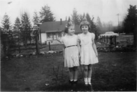
- Photograph of Sharon McLean and Kathryn Small standing in front the Hardys' house at 3093 Douglas Road. Both girls wear white dresses and party hats. The photograph was taken from 5493 (previously 3107) Dominion Street, looking east.
- Repository
- City of Burnaby Archives
- Date
- February 18, 1955
- Collection/Fonds
- Small family fonds
- Physical Description
- 1 photograph : b&w copy print ; 12 cm x 17 cm
- Description Level
- Item
- Record No.
- 620-021
- Access Restriction
- No restrictions
- Reproduction Restriction
- No reproduction permitted
- Accession Number
- 2017-01
- Scope and Content
- Photograph of Sharon McLean and Kathryn Small standing in front the Hardys' house at 3093 Douglas Road. Both girls wear white dresses and party hats. The photograph was taken from 5493 (previously 3107) Dominion Street, looking east.
- Media Type
- Photograph
- Notes
- Title based on contents of photograph
- Note in black ink on verso of photograph reads: "Sharon McLean Kahryn Small / Feb. 18/55"
- Note in blue ink on verso of photograph reads: "P.21"
- Note in blue ink on verso of photograph reads: "Courtesy of [name]"
- 3107 Dominion Street later renumbered 5493 Dominion Street and then subdivided into two lots: 5491 and 5495 Dominion Street.
- Street Address
- 3093 Douglas Road
- Historic Neighbourhood
- Burnaby Lake (Historic Neighbourhood)
- Planning Study Area
- Ardingley-Sprott Area
Images


Looking east from 5493 Dominion Street
https://search.heritageburnaby.ca/link/archivedescription91841
- Repository
- City of Burnaby Archives
- Date
- 1959
- Collection/Fonds
- Small family fonds
- Description Level
- Item
- Physical Description
- 1 photograph : b&w copy print ; 11.5 cm x 10 cm
- Scope and Content
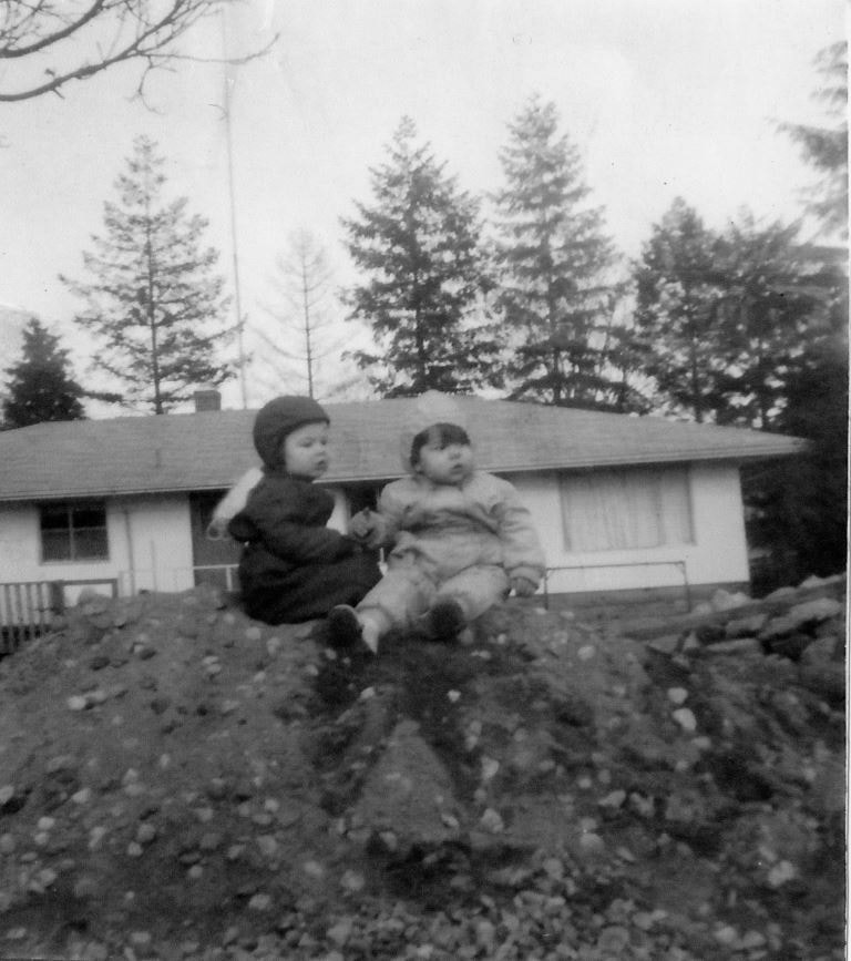
- Photograph of the Brocklebank children Brian and Pam, sitting on a dirt pile in front their single-storey house. The Hardys sold the north half of their property at 3071 Douglas Road to the Brocklebanks who built the house in 1957. The photograph was taken from 5493 (previously 3107) Dominion Str…
- Repository
- City of Burnaby Archives
- Date
- 1959
- Collection/Fonds
- Small family fonds
- Physical Description
- 1 photograph : b&w copy print ; 11.5 cm x 10 cm
- Description Level
- Item
- Record No.
- 620-022
- Access Restriction
- No restrictions
- Reproduction Restriction
- No reproduction permitted
- Accession Number
- 2017-01
- Scope and Content
- Photograph of the Brocklebank children Brian and Pam, sitting on a dirt pile in front their single-storey house. The Hardys sold the north half of their property at 3071 Douglas Road to the Brocklebanks who built the house in 1957. The photograph was taken from 5493 (previously 3107) Dominion Street, looking east.
- Media Type
- Photograph
- Notes
- Transcribed title
- Title transcribed from donor's notes
- Note in blue ink on verso of photograph reads: "P.22"
- Note in blue ink on verso of photograph reads: "Courtesy of [name]"
- Street Address
- 3071 Douglas Road
- Historic Neighbourhood
- Burnaby Lake (Historic Neighbourhood)
- Planning Study Area
- Ardingley-Sprott Area
Images