Narrow Results By
A Sound Investment
https://search.heritageburnaby.ca/link/archivedescription66108
- Repository
- City of Burnaby Archives
- Date
- 1926
- Collection/Fonds
- Burnaby Historical Society fonds
- Description Level
- Item
- Physical Description
- 1 brochure
- Scope and Content
- Item is a brochure entitled "A Sound Investment" which includes a "Map Showing Location of Burnaby Reverted Lands Now Offered for Sale."
- Repository
- City of Burnaby Archives
- Date
- 1926
- Collection/Fonds
- Burnaby Historical Society fonds
- Subseries
- Richard Bolton subseries
- Physical Description
- 1 brochure
- Description Level
- Item
- Record No.
- MSS153-001
- Accession Number
- BHS1986-09
- Scope and Content
- Item is a brochure entitled "A Sound Investment" which includes a "Map Showing Location of Burnaby Reverted Lands Now Offered for Sale."
- Media Type
- Textual Record
- Cartographic Material
- Notes
- Transcribed title
Bancroft family subseries
https://search.heritageburnaby.ca/link/archivedescription63795
- Repository
- City of Burnaby Archives
- Date
- [1900]-1979
- Collection/Fonds
- Burnaby Historical Society fonds
- Description Level
- Subseries
- Physical Description
- Textual records and other materials
- Scope and Content
- Subseries consists of publications, correspondence and other miscellaneous papers relating to the Bancroft family's interests and work history. Topics include gardening, raising poultry, the Liberal government and the Royal Canadian Air Force. Also included in the subseries are photographs of the…
- Repository
- City of Burnaby Archives
- Date
- [1900]-1979
- Collection/Fonds
- Burnaby Historical Society fonds
- Subseries
- Bancroft family subseries
- Physical Description
- Textual records and other materials
- Description Level
- Subseries
- Accession Number
- BHS1986-44
- BHS2004-06
- Scope and Content
- Subseries consists of publications, correspondence and other miscellaneous papers relating to the Bancroft family's interests and work history. Topics include gardening, raising poultry, the Liberal government and the Royal Canadian Air Force. Also included in the subseries are photographs of the Bancroft family and friends and ephemera pertaining to agricultural farming and the air force.
- History
- Rose Croucher was born to Ann Eliza "Annie" (b. August 1861, d. 1962) and R. Coucher in January 1895. In 1907, the Croucher family moved to British Columbia. As a student, Rose studied geometrical drawing using Blair’s Canadian Drawing Series workbooks. On on February 21, 1914, Rose married James Oakes Bancroft in Vancouver, BC. Together they had three children: James A. (b. 1916 or 1917), Rosie (date unknown), and George E. (b. August 1927). The Bancroft family were poultry farmers throughout the early 1900s, transporting their farmed eggs from Burnaby to the Hudson’s Bay Company Vancouver using the British Columbia Electric Railway system. Rose Bancroft also served as Secretary-Treasurer of the Central Park Poultry Co-op Association in the 1920s until her husband's death in 1930 at the age of 42. In the late thirties and early forties, while James A. Bancroft was stationed in Calgary with the Royal Canadian Air Force, his younger siblings lived together with their mother and grandmother at 1963 21st Avenue in Burnaby. Rosie Bancroft studied French and English history in Social Studies in 1937; her brother George studied the seasons in General Science II in 1942. Rose died in 1965 at the age of 76.
- Media Type
- Textual Record
- Photograph
- Cartographic Material
- Creator
- Bancroft, Rose
- Notes
- MSS030, PC490, PC507, and MSS110
- Title based on creator and contents of subseries
BC Electric Guide to Greater Vancouver
https://search.heritageburnaby.ca/link/archivedescription65826
- Repository
- City of Burnaby Archives
- Date
- April 1952
- Collection/Fonds
- Burnaby Historical Society fonds
- Description Level
- Item
- Physical Description
- 1 map : col. ; on paper ; 54 x 85 cm folded to 21 x 9 cm
- Scope and Content
- Item is the BC Electric Guide to Greater Vancouver consisting of a transit system map of Greater Vancouver, a Greater Vancouver Street Index along with listings for Parks, Golf and Country Clubs, etc.
- Repository
- City of Burnaby Archives
- Date
- April 1952
- Collection/Fonds
- Burnaby Historical Society fonds
- Subseries
- Pixie McGeachie subseries
- Physical Description
- 1 map : col. ; on paper ; 54 x 85 cm folded to 21 x 9 cm
- Material Details
- Scale : one inch equals approximately 0.57 miles
- Description Level
- Item
- Record No.
- 42686
- Accession Number
- BHS1996-08
- Scope and Content
- Item is the BC Electric Guide to Greater Vancouver consisting of a transit system map of Greater Vancouver, a Greater Vancouver Street Index along with listings for Parks, Golf and Country Clubs, etc.
- Media Type
- Cartographic Material
Burnaby
https://search.heritageburnaby.ca/link/archivedescription65839
- Repository
- City of Burnaby Archives
- Date
- June 1977
- Collection/Fonds
- Burnaby Historical Society fonds
- Description Level
- Item
- Physical Description
- 1 map : col. ink on paper ; 77 x 55 cm folded to 28 x 19 cm
- Scope and Content
- Item is a map of Burnaby District Municipality, British Columbia, compiled by the Burnaby Planning Department. The map indicates locations of schools, parks, cemeteries, improved streets and private roads, etc.
- Repository
- City of Burnaby Archives
- Date
- June 1977
- Collection/Fonds
- Burnaby Historical Society fonds
- Subseries
- Municipal record subseries
- Physical Description
- 1 map : col. ink on paper ; 77 x 55 cm folded to 28 x 19 cm
- Material Details
- Scale : 1 cm = 1/8 of a mile
- Description Level
- Item
- Record No.
- 42694
- Accession Number
- BHS2007-04
- Scope and Content
- Item is a map of Burnaby District Municipality, British Columbia, compiled by the Burnaby Planning Department. The map indicates locations of schools, parks, cemeteries, improved streets and private roads, etc.
- Media Type
- Cartographic Material
Burnaby Sewer Division records
https://search.heritageburnaby.ca/link/archivedescription62792
- Repository
- City of Burnaby Archives
- Date
- [1959] -1964
- Collection/Fonds
- Burnaby Historical Society fonds
- Description Level
- File
- Physical Description
- 1 file of textual records
- Scope and Content
- File consists of a 1963 map of the sewer areas in Burnaby along with accompanying Schedules of Construction from the Burnaby Sewers Division for the years 1964 through 1966. Included in the file is an oversized street map of Burnaby produced between 1958 and 1964 which has names annotated in pencil…
- Repository
- City of Burnaby Archives
- Date
- [1959] -1964
- Collection/Fonds
- Burnaby Historical Society fonds
- Physical Description
- 1 file of textual records
- Description Level
- File
- Record No.
- MSS093-015
- Access Restriction
- Open access
- Accession Number
- BHS2000-01
- Scope and Content
- File consists of a 1963 map of the sewer areas in Burnaby along with accompanying Schedules of Construction from the Burnaby Sewers Division for the years 1964 through 1966. Included in the file is an oversized street map of Burnaby produced between 1958 and 1964 which has names annotated in pencil on properties west of Burnaby Lake (Broadview neighbourhood).
- Media Type
- Textual Record
- Cartographic Material
- Notes
- Title based on contents of file
Burnaby Zoning Map
https://search.heritageburnaby.ca/link/archivedescription58303
- Repository
- City of Burnaby Archives
- Date
- 1973
- Collection/Fonds
- Burnaby Historical Society fonds
- Description Level
- Item
- Physical Description
- 1 map
- Scope and Content
- Item is a Burnaby Zoning Map describing Bylaw no. 4742 (collected by Evelyn Salisbury).
- Repository
- City of Burnaby Archives
- Date
- 1973
- Collection/Fonds
- Burnaby Historical Society fonds
- Subseries
- Evelyn Salisbury subseries
- Physical Description
- 1 map
- Description Level
- Item
- Record No.
- MSS061-100
- Access Restriction
- No restrictions
- Accession Number
- BHS1991-24
- Scope and Content
- Item is a Burnaby Zoning Map describing Bylaw no. 4742 (collected by Evelyn Salisbury).
- Media Type
- Cartographic Material
City of Burnaby Archives
https://search.heritageburnaby.ca/link/landmark783
- Repository
- Burnaby Heritage Planning
- Geographic Access
- Albert Street
- Associated Dates
- 2001
- Heritage Value
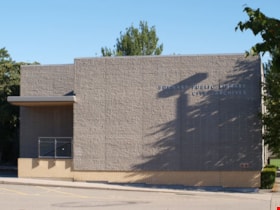
- The City of Burnaby Archives officially opened on Saturday, November 10, 2001. The Archives is Burnaby's first municipal archives, and is located in the McGill Branch Library. The City Archives functions as a branch of the Office of the City Clerk and operates as the official repository of Burnaby's municipal records, containing records dating back to Burnaby's incorporation in 1892. In 2007, the City of Burnaby Archives expanded its collection mandate to include private as well as public records. On February 14, 2007 an agreement was signed with the Burnaby Historical Society and, as a result, the Archives accepted into its custody the collection of community records that had been maintained and managed by the Historical Society since the 1950s. In the Spring of 2007, these records were transferred from the Burnaby Village Museum to their permanent home in the Archives facility.
- Historic Neighbourhood
- Capitol Hill (Historic Neighbourhood)
- Planning Study Area
- Capitol Hill Area
- Street Address
- 4595 Albert Street
- Street View URL
- Google Maps Street View
Images
The City of Vancouver B.C.
https://search.heritageburnaby.ca/link/archivedescription66103
- Repository
- City of Burnaby Archives
- Date
- [between 1916 and 1929]
- Collection/Fonds
- Burnaby Historical Society fonds
- Description Level
- Item
- Physical Description
- 1 map : b&w ink on paper ; 56 x 107 cm folded to 21 x 12.5 cm
- Scope and Content
- Item is a map of "[the] City of Vancouver B.C" drawn prior to amalgamation of Point Grey and South Vancouver with the City of Vancouver.
- Repository
- City of Burnaby Archives
- Date
- [between 1916 and 1929]
- Collection/Fonds
- Burnaby Historical Society fonds
- Subseries
- Ephemera subseries
- Physical Description
- 1 map : b&w ink on paper ; 56 x 107 cm folded to 21 x 12.5 cm
- Material Details
- Map has a blue construction paper cover
- Scale : 1 inch = 1000 feet
- Description Level
- Item
- Record No.
- 42707
- Accession Number
- BHS2007-04
- Scope and Content
- Item is a map of "[the] City of Vancouver B.C" drawn prior to amalgamation of Point Grey and South Vancouver with the City of Vancouver.
- Media Type
- Cartographic Material
- Notes
- Transcribed title
Community Archives Collection series
https://search.heritageburnaby.ca/link/archivedescription97126
- Repository
- City of Burnaby Archives
- Date
- [188-]-2010
- Collection/Fonds
- Burnaby Historical Society fonds
- Description Level
- Series
- Physical Description
- Textual records and other materials
- Scope and Content
- Series consists of the Burnaby Historical Society's Community Archives collection. The Society's collection includes photographs, documents, ephemera, oral histories, and other records from a myriad of sources and donors, compiled to document the history of Burnaby.
- Repository
- City of Burnaby Archives
- Date
- [188-]-2010
- Collection/Fonds
- Burnaby Historical Society fonds
- Physical Description
- Textual records and other materials
- Description Level
- Series
- Scope and Content
- Series consists of the Burnaby Historical Society's Community Archives collection. The Society's collection includes photographs, documents, ephemera, oral histories, and other records from a myriad of sources and donors, compiled to document the history of Burnaby.
- History
- The Burnaby Historical was founded in 1957. The Historical Society developed its Community Archives by collecting, compiling, and preserving records with historic value to the City of Burnaby. It gathered documents, photographs, and other items while also soliciting and acquiring entire collections or groups of archival records. In 1991, the Society was provided a permanent space to house their growing collection at the Burnaby Village Museum and they continued to grow their holdings. Following the creation of the City of Burnaby Archives in 2001, the Society and the City of Burnaby began discussing the possibility of uniting the two collections. In February 2007, an agreement was signed between the two institutions which resulted in the merger of the Society's Community Archives with the City Archives. All records collected by the Society were transferred into the custody of the City and moved from the Burnaby Village Museum to the City Archives in the McGill branch of the Burnaby Public Library.
- Notes
- Title based on contents of series
Dease Lake survey map
https://search.heritageburnaby.ca/link/archivedescription64449
- Repository
- City of Burnaby Archives
- Date
- April 12, 1944
- Collection/Fonds
- Burnaby Historical Society fonds
- Description Level
- Item
- Physical Description
- 1 map
- Scope and Content
- Item is a Dease Lake survey map produced by the Canada Department of Mines and Resources, Surveys and Engineering Branch.
- Repository
- City of Burnaby Archives
- Date
- April 12, 1944
- Collection/Fonds
- Burnaby Historical Society fonds
- Subseries
- Bancroft family subseries
- Physical Description
- 1 map
- Description Level
- Item
- Record No.
- MSS110-037
- Accession Number
- BHS2004-06
- Scope and Content
- Item is a Dease Lake survey map produced by the Canada Department of Mines and Resources, Surveys and Engineering Branch.
- Media Type
- Cartographic Material
Dial map of Greater Vancouver and Suburbs
https://search.heritageburnaby.ca/link/archivedescription65840
- Repository
- City of Burnaby Archives
- Date
- 1958
- Collection/Fonds
- Burnaby Historical Society fonds
- Description Level
- Item
- Physical Description
- 1 map : col. ; ink on sheet 55 x 73 cm folded to 28 x 14 cm
- Scope and Content
- Item is a Dial map of Greater Vancouver and Suburbs, published by Dominion Map and Blueprint Ltd. in Vancouver. Map includes both old and new street names.
- Repository
- City of Burnaby Archives
- Date
- 1958
- Collection/Fonds
- Burnaby Historical Society fonds
- Subseries
- Municipal record subseries
- Physical Description
- 1 map : col. ; ink on sheet 55 x 73 cm folded to 28 x 14 cm
- Material Details
- Scale : 1 1/4 inches = 1 mile
- Description Level
- Item
- Record No.
- 42695
- Access Restriction
- Open access
- Accession Number
- BHS1999-05
- Scope and Content
- Item is a Dial map of Greater Vancouver and Suburbs, published by Dominion Map and Blueprint Ltd. in Vancouver. Map includes both old and new street names.
- Media Type
- Cartographic Material
Display Panels at Municipal Hall - Burnaby Historical Society
https://search.heritageburnaby.ca/link/councilreport42352
- Repository
- City of Burnaby Archives
- Report ID
- 38131
- Meeting Date
- 10-Mar-1958
- Format
- Council - Committee Report
- Collection/Fonds
- City Council and Office of the City Clerk fonds
- Repository
- City of Burnaby Archives
- Report ID
- 38131
- Meeting Date
- 10-Mar-1958
- Format
- Council - Committee Report
- Collection/Fonds
- City Council and Office of the City Clerk fonds
Documents
Ephemera subseries
https://search.heritageburnaby.ca/link/archivedescription97408
- Repository
- City of Burnaby Archives
- Date
- 1893 (date of original)-2004
- Collection/Fonds
- Burnaby Historical Society fonds
- Description Level
- Subseries
- Physical Description
- Textual records and cartographic records
- Scope and Content
- Subseries consists of newspapers, printed material, publications, artworks, maps and other ephemera items collected or purchased by the Burnaby Historical Society for inclusion in their Community Archives.
- Repository
- City of Burnaby Archives
- Date
- 1893 (date of original)-2004
- Collection/Fonds
- Burnaby Historical Society fonds
- Subseries
- Ephemera subseries
- Physical Description
- Textual records and cartographic records
- Description Level
- Subseries
- Accession Number
- BHS1985-22
- BHS1986-01
- BHS1986-16
- BHS1986-43
- BHS1988-02
- BHS1988-12
- BHS1988-14
- BHS1989-09
- BHS1989-11
- BHS1989-14
- BHS1989-16
- BHS1991-26
- BHS1991-35
- BHS1991-40
- BHS1992-01
- BHS1994-09
- BHS1995-13
- BHS1995-17
- BHS1996-10
- BHS1997-06
- BHS1997-10
- BHS1999-04
- BHS1999-08
- BHS2000-12
- BHS2004-09
- BHS2004-11
- BHS2005-04
- BHS2005-05
- BHS2007-03
- BHS2007-04
- Scope and Content
- Subseries consists of newspapers, printed material, publications, artworks, maps and other ephemera items collected or purchased by the Burnaby Historical Society for inclusion in their Community Archives.
- Media Type
- Textual Record
- Cartographic Material
- Notes
- Title based on content of subseries
- PC212, PC219, PC472, PC598, MSS005, MSS010, MSS034, MSS038, MSS046, MSS076, MSS081, MSS090, MSS111, MSS114, MSS119, MSS195
Game Regulation Map of British Columbia
https://search.heritageburnaby.ca/link/archivedescription65823
- Repository
- City of Burnaby Archives
- Date
- 1954
- Collection/Fonds
- Burnaby Historical Society fonds
- Description Level
- Item
- Physical Description
- 1 map : col. ; on sheet 55 x 70 cm folded to 23 x 11 cm + 1 p. (newsprint)
- Scope and Content
- Item is the "Game Regulation Map of British Columbia" for the 1954-1955 hunting season showing provincial electoral districts.
- Repository
- City of Burnaby Archives
- Date
- 1954
- Collection/Fonds
- Burnaby Historical Society fonds
- Subseries
- Ephemera subseries
- Physical Description
- 1 map : col. ; on sheet 55 x 70 cm folded to 23 x 11 cm + 1 p. (newsprint)
- Material Details
- 1 p. accompanying is a newspaper clipping from the Vancouver Sun dated August 6, 1954 that pertains to the "new" game regulations
- Scale : 1 inch = 40 miles
- Description Level
- Item
- Record No.
- 42684
- Accession Number
- BHS2007-04
- Scope and Content
- Item is the "Game Regulation Map of British Columbia" for the 1954-1955 hunting season showing provincial electoral districts.
- Media Type
- Cartographic Material
Grant Applications
https://search.heritageburnaby.ca/link/councilreport157
- Repository
- City of Burnaby Archives
- Report ID
- 66995
- Meeting Date
- 28-May-2007
- Format
- Council - Committee Report
- Collection/Fonds
- City Council and Office of the City Clerk fonds
- Repository
- City of Burnaby Archives
- Report ID
- 66995
- Meeting Date
- 28-May-2007
- Format
- Council - Committee Report
- Collection/Fonds
- City Council and Office of the City Clerk fonds
Documents
Graphic Map and Street Guide of Vancouver British Columbia / Graphic Publishers Canada
https://search.heritageburnaby.ca/link/archivedescription46977
- Repository
- City of Burnaby Archives
- Date
- [ca. 1950]
- Collection/Fonds
- Burnaby Historical Society fonds
- Description Level
- Item
- Physical Description
- 1 map
- Scope and Content
- Map and street guide of Vancouver, including North Vancouver, West Vancouver, Burnaby, New Westminster and Lulu Island. Map also includes an index of parks, schools, hospitals and other places of interest.
- Repository
- City of Burnaby Archives
- Date
- [ca. 1950]
- Collection/Fonds
- Burnaby Historical Society fonds
- Subseries
- Ephemera subseries
- Physical Description
- 1 map
- Description Level
- Item
- Record No.
- 37274
- Accession Number
- 2008-19
- Scope and Content
- Map and street guide of Vancouver, including North Vancouver, West Vancouver, Burnaby, New Westminster and Lulu Island. Map also includes an index of parks, schools, hospitals and other places of interest.
- Media Type
- Cartographic Material
H.T. Ceperley Estate 'Fairacres' Chauffeur's Cottage
https://search.heritageburnaby.ca/link/landmark529
- Repository
- Burnaby Heritage Planning
- Description
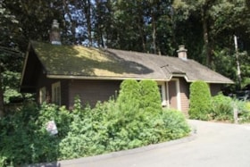
- Designed in the British Arts and Crafts style, the Chauffeur's Cottage is situated across from the main entrance to the Ceperley Mansion, and adjacent to the Garage and Stables. A long, narrow single-storey building, it was constructed by joining together two modest estate cottages.
- Associated Dates
- 1911
- Formal Recognition
- Heritage Designation, Community Heritage Register
- Repository
- Burnaby Heritage Planning
- Geographic Access
- Deer Lake Avenue
- Associated Dates
- 1911
- Formal Recognition
- Heritage Designation, Community Heritage Register
- Enactment Type
- Bylaw No. 9807
- Enactment Date
- 23/11/1992
- Description
- Designed in the British Arts and Crafts style, the Chauffeur's Cottage is situated across from the main entrance to the Ceperley Mansion, and adjacent to the Garage and Stables. A long, narrow single-storey building, it was constructed by joining together two modest estate cottages.
- Heritage Value
- The outbuildings at 'Fairacres' are a rare surviving architecturally designed ensemble of agricultural structures that exist in complementary harmony with the main estate house. Architect Robert Mackay Fripp (1858-1917) was retained by the Ceperleys to design several original outbuildings on their estate at the same time as the main house was constructed. The Chauffeur's Cottage illustrates the increasing importance of the automobile in the lives of the wealthy of the early twentieth century. It also demonstrates Grace and Henry Tracy Ceperley's social aspirations and grand-country-estate pretension in having a chauffeur. The cottage's location - close to the garage and convenient, but not adjacent, to the main house - enhances the grand country house landscape design and contributes to the overall composition of the estate's plan. The Arts and Crafts styled Chauffeur's Cottage is important as an indicator of the aesthetic and social sensibilities of the Ceperley family in retaining an architect to design a modest building for staff accommodation.
- Defining Elements
- Key elements that define the heritage character of the 'Fairacres' Chauffeur's Cottage include its: - location, in relation to the main house and in close proximity to the Garage and Stables buildings - side gable roof with cedar shingle cladding - Arts and Crafts architectural features such as the jerkin-headed door hood, a reference to the thatched-roofed cottages of southern England; eight-paned wooden-sash casement windows; and cedar-shingled exterior - two internal brick chimneys - modest, functional interior, with simple trim and lack of pretension
- Locality
- Deer Lake Park
- Historic Neighbourhood
- Burnaby Lake (Historic Neighbourhood)
- Planning Study Area
- Douglas-Gilpin Area
- Architect
- Robert Mackay Fripp
- Function
- Primary Historic--Outbuilding
- Community
- Burnaby
- Cadastral Identifier
- P.I.D. No. 004-493-311 Legal Description: Block 3 Except: Part subdivided by Plan 26865, District Lot 79, Group 1, New Westminster District, Plan 536
- Boundaries
- ‘Fairacres’ is comprised of a single municipally-owned property located at 6344 Deer Lake Avenue, Burnaby.
- Area
- 17,065.00
- Contributing Resource
- Building
- Landscape Feature
- Ownership
- Public (local)
- Other Collection
- Burnaby Historical Society, Community Archives: Ceperley Photograph Album Burnaby Village Museum, Collection: Chinese ‘Tiger Whiskey’ and opium bottles found during restoration
- Documentation
- Heritage Site Files: PC77000 20. City of Burnaby Planning and Building Department, 4949 Canada Way, Burnaby, B.C., V5G 1M2
- Street Address
- 6344 Deer Lake Avenue
Images
H.T. Ceperley Estate 'Fairacres' Estate Gate
https://search.heritageburnaby.ca/link/landmark863
- Repository
- Burnaby Heritage Planning
- Description
- The 'Fairacres Estate Gate' marks the location of one of the original driveway entrances to the estate.
- Associated Dates
- 1911
- Formal Recognition
- Heritage Designation, Community Heritage Register
- Street View URL
- Google Maps Street View
- Repository
- Burnaby Heritage Planning
- Geographic Access
- Deer Lake Avenue
- Associated Dates
- 1911
- Formal Recognition
- Heritage Designation, Community Heritage Register
- Enactment Type
- Bylaw No. 140665
- Enactment Date
- 23/11/1992
- Description
- The 'Fairacres Estate Gate' marks the location of one of the original driveway entrances to the estate.
- Heritage Value
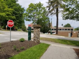
- Fairacres was designed as a country estate with a working farm that included over 10 acres of productive berry and vegetable fields, with a large kitchen garden, a root house to store food, and greenhouses heated by steam. The agricultural potential ofthe Deer Lake area made it one of the first parts of the municipality to attract settlement. Construction of the Fairacres Estate represented a shift toward wealthy country estates over more modest farms, and the Ceperleys employed a large staff to manage the estate's agricultural production. Agricultural use of the estate continued when a Catholic order of Benedictine monks purchased the estate as part of the Priory of St. Joseph and the Seminary of Christ the King, and continued to farm the land until 1953. The overall architectural intention of the estate's architect was to reflect the ideals of the Arts & Crafts movement to showcase craftsmanship, and to incorporate high quality materials, including many local materials, such as wood and stone from the site. On the mansion exterior, the rustic style is seen in the use of natural materials such as cedar shingles and siding, cobblestone foundations and chimneys and the half-timbering in gable ends. The estate's remaining gate pillar features the same rustic field and cobblestones used on the mansion. The original estate driveway had two entrances constructed in 1910, each marked by a pair of entry gate pillars which supported iron gates. The main entrance gate pillars which marked the lower driveway and the east pillar of the upper entrance were demolished many years ago and the iron gates removed. A single gate pillar remains marking the upper driveway, adjacent to the Garage and Stables. This gate pillar is a significant site feature and incorporates cobble stone and a carved sandstone capstone.
- Defining Elements
- Key elements that define the heritage character of the ‘Fairacres Estate Gate' include: - setting in relation to the estate boundary and estate buildings - Cobble stone and sandstone construction, which represents a typical Arts and Crafts use of local materials, and matches the extensive use of cobblestone as chimneys and foundations on the Fairacres mansion, as well as the use of sandstone on the mansion's exterior.
- Locality
- Deer Lake Park
- Historic Neighbourhood
- Burnaby Lake (Historic Neighbourhood)
- Planning Study Area
- Douglas-Gilpin Area
- Function
- Primary Historic--Estate
- Community
- Burnaby
- Cadastral Identifier
- P.I.D. No. 004-493-311 Legal Description: Block 3 Except: Part subdivided by Plan 26865, District Lot 79, Group 1, New Westminster District, Plan 536
- Boundaries
- ‘Fairacres’ is comprised of a single municipally-owned property located at 6344 Deer Lake Avenue, Burnaby.
- Area
- 17,065.00
- Contributing Resource
- Landscape Feature
- Ownership
- Public (local)
- Other Collection
- Burnaby Historical Society, Community Archives: Ceperley Photograph Album
- Documentation
- Heritage Site Files: PC77000 20. City of Burnaby Planning and Building Department, 4949 Canada Way, Burnaby, B.C., V5G 1M2
- Subjects
- Structures - Fences
- Street Address
- 6344 Deer Lake Avenue
- Street View URL
- Google Maps Street View
Images
H.T. Ceperley Estate 'Fairacres' Garage & Stables
https://search.heritageburnaby.ca/link/landmark530
- Repository
- Burnaby Heritage Planning
- Description
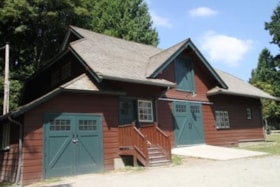
- Designed in the British Arts and Crafts style, the ‘Fairacres’ Garage and Stables is a two-storey wood frame building located on the 'Fairacres' estate, situated to the north of the Chauffeur's Cottage; at the south end of the structure is a single vehicle garage and to the north are several stable…
- Associated Dates
- 1911
- Formal Recognition
- Heritage Designation, Community Heritage Register
- Street View URL
- Google Maps Street View
- Repository
- Burnaby Heritage Planning
- Geographic Access
- Deer Lake Avenue
- Associated Dates
- 1911
- Formal Recognition
- Heritage Designation, Community Heritage Register
- Enactment Type
- Bylaw No. 9807
- Enactment Date
- 23/11/1992
- Description
- Designed in the British Arts and Crafts style, the ‘Fairacres’ Garage and Stables is a two-storey wood frame building located on the 'Fairacres' estate, situated to the north of the Chauffeur's Cottage; at the south end of the structure is a single vehicle garage and to the north are several stables for carriage, riding, and draught horses, a coach house, and tack room; the upper floor was originally a hay loft.
- Heritage Value
- The outbuildings at 'Fairacres' are a rare surviving architecturally designed ensemble of agricultural structures that exist in complementary harmony with the main estate house. Architect Robert Mackay Fripp (1858-1917) was retained by the Ceperleys to design several original outbuildings on their estate at the same time as the main house was constructed. The Garage and Stables building is important as a record of its era when transportation modes were in transition and the horse-drawn carriage, while still in use, was giving way to the automobile. The relative spatial arrangements within the building are a valuable indication of the economy of space associated with the automobile, as compared to the horse. The extent of the stabling arrangements signifies not only the use of carriage horses but also the continued reliance on draught horses in farming activities in this era. As well, it is an indication of the fashionable nature of equestrianism for wealthy families during this time. The building is important as a demonstration of the aesthetics of the Ceperley family in having an architect-designed outbuilding and obtaining craftsmanship and materials of the highest quality for each structure on their estate.
- Defining Elements
- Key elements that define the heritage character of the 'Fairacres' Garage and Stables include its: - location within easy reach of the main house and in close proximity to the Chauffeur's Cottage - floor plan with the garage at one end, close to the Chauffeur's Cottage, and stables and equine facilities at the other - variety and complexity of the roofline, including gable wall dormers, gable-on-hip roof ends, and half-hip extensions - Arts and Crafts architectural features of the exterior such as the shingle wall cladding articulated with a chevron-patterned course of shingles at the first floor level; casement windows; and deep eaves with additional purlins to support the overhang - original stable doors with hand-made forged-iron door hardware - multi-paned wooden-sash windows, some retaining original wire glass
- Locality
- Deer Lake Park
- Historic Neighbourhood
- Burnaby Lake (Historic Neighbourhood)
- Planning Study Area
- Douglas-Gilpin Area
- Architect
- Robert Mackay Fripp
- Function
- Primary Historic--Outbuilding
- Community
- Burnaby
- Cadastral Identifier
- P.I.D. No. 004-493-311 Legal Description: Block 3 Except: Part subdivided by Plan 26865, District Lot 79, Group 1, New Westminster District, Plan 536
- Boundaries
- ‘Fairacres’ is comprised of a single municipally-owned property located at 6344 Deer Lake Avenue, Burnaby.
- Area
- 17,065.00
- Contributing Resource
- Building
- Landscape Feature
- Ownership
- Public (local)
- Other Collection
- Burnaby Historical Society, Community Archives: Ceperley Photograph Album
- Documentation
- Heritage Site Files: PC77000 20. City of Burnaby Planning and Building Department, 4949 Canada Way, Burnaby, B.C., V5G 1M2
- Street Address
- 6344 Deer Lake Avenue
- Street View URL
- Google Maps Street View
Images
H.T. Ceperley Estate 'Fairacres' Greenhouse Foundation Wall
https://search.heritageburnaby.ca/link/landmark862
- Repository
- Burnaby Heritage Planning
- Description
- The original rubble stone walls that formed the foundation for a greenhouses adjacent to the Steam Plant Building provided heat to several greenhouses on the estate propoerty. The Root House, which is to the north of the Greenhouse Foundation Wall, provided storage for the farm operation.
- Associated Dates
- 1908
- Formal Recognition
- Heritage Designation, Community Heritage Register
- Repository
- Burnaby Heritage Planning
- Geographic Access
- Deer Lake Avenue
- Associated Dates
- 1908
- Formal Recognition
- Heritage Designation, Community Heritage Register
- Enactment Type
- Bylaw No. 140665
- Enactment Date
- 23/11/1992
- Description
- The original rubble stone walls that formed the foundation for a greenhouses adjacent to the Steam Plant Building provided heat to several greenhouses on the estate propoerty. The Root House, which is to the north of the Greenhouse Foundation Wall, provided storage for the farm operation.
- Heritage Value
- The outbuildings at 'Fairacres' are a rare surviving architecturally-designed ensemble of agricultural structures that exist in complementary harmony with the main estate house. Architect Robert Mackay Fripp (1858-1917), an outspoken advocate of Arts and Crafts design, was retained by the Ceperleys to design several original outbuildings on their estate, which was designed as a country estate with a working farm that included over 10 acres of productive berry and vegetable fields, with a large kitchen garden, a root house to store food, an orchard, and greenhouses heated by steam. The agricultural potential of the Deer Lake area made it one of the first parts of the municipality to attract settlement. In 1909, the Ceperleys built three large greenhouses heated by an adjacent steam plant (Fairacres Steam Plant). The greenhouses featured granite foundation walls, including this one which remains intact. The Ceperleys employed a large staff to manage the estate's agricultural production, including Chinese farm labourers. Produce was grown for use at the estate, and for sale at local markets. Agricultural use of the estate continued when a Catholic order of Benedictine monks purchased the estate as part of the Priory of St. Joseph and the Seminary of Christ the King, and continued to farm the land until 1953.
- Defining Elements
- Key elements that define the heritage character of the ‘Fairacres’ Steam Plant Building include its: - overall spatial arrangement of the Greenhouse Foundation Wall in relation to the Steam Plant Building and the Root House - original rubble stone walls reflecting the Arts and Crafts design aesthetic of the estate buildings.
- Locality
- Deer Lake Park
- Historic Neighbourhood
- Burnaby Lake (Historic Neighbourhood)
- Planning Study Area
- Douglas-Gilpin Area
- Architect
- Robert Mackay Fripp
- Function
- Primary Historic--Outbuilding
- Community
- Burnaby
- Cadastral Identifier
- P.I.D. No. 004-493-311 Legal Description: Block 3 Except: Part subdivided by Plan 26865, District Lot 79, Group 1, New Westminster District, Plan 536
- Boundaries
- ‘Fairacres’ is comprised of a single municipally-owned property located at 6344 Deer Lake Avenue, Burnaby.
- Area
- 17,065.00
- Contributing Resource
- Landscape Feature
- Remains
- Ownership
- Public (local)
- Other Collection
- Burnaby Historical Society, Community Archives: Ceperley Photograph Album
- Documentation
- Heritage Site Files: PC77000 20. City of Burnaby Planning and Building Department, 4949 Canada Way, Burnaby, B.C., V5G 1M2
- Street Address
- 6344 Deer Lake Avenue
