Narrow Results By
Subject
- Agriculture - Farms 5
- Agriculture - Poultry 1
- Animals - Cats 1
- Animals - Dogs 5
- Animals - Goats 1
- Animals - Poultry 1
- Buildings - Agricultural 1
- Buildings - Agricultural - Barns 2
- Buildings - Civic - Museums 1
- Buildings - Commercial - Stores 2
- Buildings - Heritage 34
- Buildings - Religious - Churches 1

E.W. Bateman House 'Elworth'
https://search.heritageburnaby.ca/link/landmark538
- Repository
- Burnaby Heritage Planning
- Description
- The E.W. Bateman House is a one-and-one-half storey wood-frame residence set within in a garden landscape. The house and its adjacent garage are the only historic buildings standing on their original site within the Burnaby Village Museum property.
- Associated Dates
- 1922
- Formal Recognition
- Heritage Designation, Community Heritage Register
- Other Names
- Edwin & Mary Bateman Residence
- Street View URL
- Google Maps Street View
- Repository
- Burnaby Heritage Planning
- Other Names
- Edwin & Mary Bateman Residence
- Geographic Access
- Deer Lake Avenue
- Associated Dates
- 1922
- Formal Recognition
- Heritage Designation, Community Heritage Register
- Enactment Type
- Bylaw No. 9807
- Enactment Date
- 23/11/1992
- Description
- The E.W. Bateman House is a one-and-one-half storey wood-frame residence set within in a garden landscape. The house and its adjacent garage are the only historic buildings standing on their original site within the Burnaby Village Museum property.
- Heritage Value
- The E.W. Bateman House was constructed in the Deer Lake Crescent subdivision, that was originally promoted in 1911 as an upper class suburban neighbourhood. It represents one of the first residential developments in the City of Burnaby that required buildings to be of a specific value, thus demonstrating the desire for exclusivity among the successful businessmen who chose to settle in the area. The house and grounds illustrate the reduced scale of upper-class residential construction at a time of modest returning prosperity that followed the end of the First World War, and the social, cultural, lifestyle and leisure sensibilities of the owners in the Deer Lake Crescent subdivision: such values as social aspiration, racial exclusivity, demonstration of architectural taste, and importance of a landscaped garden. The heritage value of the E.W. Bateman House is its comprehensive representation of an upper middle-class suburban residence of the early 1920s. It was built for retired CPR executive Edwin Wettenhall Bateman (1859-1957) and his wife, Mary (Dale) Bateman (1865-1935), by contractor William Dodson in 1922. The Bateman House was designed by English-born and trained architect Enoch Evans (1862-1939) of E. Evans and Son, and is an important surviving residential design by Evans, and a typical example of the eclectic Period Revival influences that were common to domestic architecture in the post-First World War era. The symmetry of the imposing front verandah, supported by exaggerated Ionic columns, gives the relatively-modest house an image of grandeur and formality. Named after Edwin Bateman’s birthplace in Cheshire, England, ‘Elworth’ also symbolizes allegiance to England and the patriotic tenor of the time. The heritage value for this house also lies in its interpretive value within the Burnaby Village Museum. The site is an important cultural feature for the interpretation of Burnaby’s heritage to the public. The E.W. Bateman House was purchased by Burnaby in 1970 and became the focal point for the development of the Museum. Both the interior and exterior of the house have been restored and interpreted to the date of original construction, including recreated room interiors and period furnishings.
- Defining Elements
- The elements that define the heritage character of the E.W. Bateman House include its: - rectangular form and massing with central entry on long side - side gable roof with front shed dormer with cedar shingle cladding - symmetry of front facade - full open front verandah inset under the roofline, supported with Ionic columns - cedar shingle siding - multi-paned double-hung wooden-sash windows, mixture of 6-over-1 and 8-over-1 - symmetrical disposition of fenestration, with double-assembly units on the ground floor - exterior shutters - two flanking brick chimneys on the side elevations - interior room layouts and original interior features such as quality millwork and original hardware - original garage at the rear of the house
- Locality
- Deer Lake Park
- Historic Neighbourhood
- Burnaby Lake (Historic Neighbourhood)
- Planning Study Area
- Morley-Buckingham Area
- Organization
- Burnaby Village Museum
- Architect
- Enoch Evans
- E. Evans and Son
- Builder
- William Dodson
- Function
- Primary Current--Museum
- Primary Historic--Single Dwelling
- Community
- Burnaby
- Cadastral Identifier
- P.I.D. No. 011-030-356 Legal Description: Parcel 1, District Lot 79 and District Lot 85, Group 1, New Westminster District, Reference Plan 77594
- Boundaries
- Burnaby Village Museum is comprised of a single municipally-owned property located at 6501 Deer Lake Avenue, Burnaby.
- Area
- 38,488.63
- Contributing Resource
- Building
- Landscape Feature
- Structure
- Ownership
- Public (local)
- Documentation
- Heritage Site Files: PC77000 20. City of Burnaby Planning and Building Department, 4949 Canada Way, Burnaby, B.C., V5G 1M2
- Subjects
- Buildings - Residential
- Buildings - Residential - Houses
- Buildings - Heritage
- Buildings - Civic - Museums
- Street Address
- 6501 Deer Lake Avenue
- Street View URL
- Google Maps Street View
Images


Barnet Lumber Company House
https://search.heritageburnaby.ca/link/landmark662
- Repository
- Burnaby Heritage Planning
- Description
- Residential building.
- Associated Dates
- 1925
- Street View URL
- Google Maps Street View
- Repository
- Burnaby Heritage Planning
- Geographic Access
- Texaco Drive
- Associated Dates
- 1925
- Description
- Residential building.
- Heritage Value
- This house is one of two surviving houses built as a “Model Home” for the manager of the Barnet Lumber Company, which was the successor to the North Pacific Lumber Company. It was used as a combined home and office. It was constructed with framing lumber and millwork sawn at the mill. Typical of the Craftsman style, the house has a front gabled roof with triangular eave brackets. It has been altered with the addition of asbestos shingles over the original siding, but retains its form, scale and massing. This house was designed by the firm of Townley & Matheson. The partnership of Fred Laughton Townley (1887-1966) and Robert Michael Matheson began in 1919, and the firm left a rich legacy of sophisticated work, including schools, commercial structures, many fine residences and the landmark Vancouver City Hall.
- Historic Neighbourhood
- Barnet (Historic Neighbourhood)
- Planning Study Area
- Burnaby Mountain Area
- Architect
- Townley & Matheson
- Area
- 2225.77
- Contributing Resource
- Building
- Ownership
- Public (local)
- Street Address
- 8007 Texaco Drive
- Street View URL
- Google Maps Street View
Images


Barnet Lumber Company House
https://search.heritageburnaby.ca/link/landmark663
- Repository
- Burnaby Heritage Planning
- Description
- Residential building.
- Associated Dates
- 1925
- Street View URL
- Google Maps Street View
- Repository
- Burnaby Heritage Planning
- Geographic Access
- Texaco Drive
- Associated Dates
- 1925
- Description
- Residential building.
- Heritage Value
- This house is one of two surviving houses built as a “Model Home” for one of the assistant managers of the Barnet Lumber Company, using framing lumber and millwork sawn at the mill. This house was also designed by the firm of Townley & Matheson. The house was raised and renovated in 1997, resulting in alterations such as new dormers and elongated porch piers.
- Historic Neighbourhood
- Barnet (Historic Neighbourhood)
- Planning Study Area
- Burnaby Mountain Area
- Architect
- Townley & Matheson
- Contributing Resource
- Building
- Ownership
- Private
- Street Address
- 8039 Texaco Drive
- Street View URL
- Google Maps Street View
Images

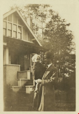
Harold Carpenter with Kathleen
https://search.heritageburnaby.ca/link/archivedescription80100
- Repository
- City of Burnaby Archives
- Date
- 1929
- Collection/Fonds
- Montgomery family fonds
- Description Level
- Item
- Physical Description
- 1 photograph : b&w ; 8 x 5.5 cm
- Scope and Content
- Photograph of Harold Carpenter with his niece Margery Kathleen "Kathleen" Montgomery (later Green) in his arms. Harold and Kathleen are in front of Fred and Edna Cunningham's house on Douglas Road (this house was given heritage designation by the City of Burnaby in 1996).
- Repository
- City of Burnaby Archives
- Date
- 1929
- Collection/Fonds
- Montgomery family fonds
- Physical Description
- 1 photograph : b&w ; 8 x 5.5 cm
- Description Level
- Item
- Record No.
- 554-003
- Access Restriction
- No restrictions
- Reproduction Restriction
- No known restrictions
- Accession Number
- 2013-14
- Scope and Content
- Photograph of Harold Carpenter with his niece Margery Kathleen "Kathleen" Montgomery (later Green) in his arms. Harold and Kathleen are in front of Fred and Edna Cunningham's house on Douglas Road (this house was given heritage designation by the City of Burnaby in 1996).
- Media Type
- Photograph
- Notes
- Title based on contents of photograph
- Note in black ink on verso of photograph reads: "Harold at the Cunninghams with Kath"
- Street Address
- 3555 Douglas Road
- Historic Neighbourhood
- Burnaby Lake (Historic Neighbourhood)
- Planning Study Area
- Douglas-Gilpin Area
Images
![Home interior, [1900-1930] thumbnail](/media/hpo/_Data/_Archives_Images/_Unrestricted/550/550-132.jpg?width=280)
Home interior
https://search.heritageburnaby.ca/link/archivedescription82561
- Repository
- City of Burnaby Archives
- Date
- [1900-1930]
- Collection/Fonds
- Hill family and Vidal family fonds
- Description Level
- Item
- Physical Description
- 1 photograph : b&w ; 9.5 x 12 cm
- Scope and Content
- Photograph shows the interior of a home, including wallpapered walls, newspapers, and a piano.
- Repository
- City of Burnaby Archives
- Date
- [1900-1930]
- Collection/Fonds
- Hill family and Vidal family fonds
- Physical Description
- 1 photograph : b&w ; 9.5 x 12 cm
- Description Level
- Item
- Record No.
- 550-132
- Access Restriction
- No restrictions
- Reproduction Restriction
- No known restrictions
- Accession Number
- 2013-03
- Scope and Content
- Photograph shows the interior of a home, including wallpapered walls, newspapers, and a piano.
- Media Type
- Photograph
- Notes
- Title based on contents of photograph
Images
![Home interior, [1900-1930] thumbnail](/media/hpo/_Data/_Archives_Images/_Unrestricted/550/550-132.jpg)
![Rural road, [1900-1930] thumbnail](/media/hpo/_Data/_Archives_Images/_Unrestricted/550/550-139.jpg?width=280)
Rural road
https://search.heritageburnaby.ca/link/archivedescription82568
- Repository
- City of Burnaby Archives
- Date
- [1900-1930]
- Collection/Fonds
- Hill family and Vidal family fonds
- Description Level
- Item
- Physical Description
- 1 photograph : sepia postcard ; 7 x 14 cm
- Scope and Content
- Photographic postcard shows house situated beside a road and amongst trees. Photograph was taken in Washington state.
- Repository
- City of Burnaby Archives
- Date
- [1900-1930]
- Collection/Fonds
- Hill family and Vidal family fonds
- Physical Description
- 1 photograph : sepia postcard ; 7 x 14 cm
- Description Level
- Item
- Record No.
- 550-139
- Access Restriction
- No restrictions
- Reproduction Restriction
- No known restrictions
- Accession Number
- 2013-03
- Scope and Content
- Photographic postcard shows house situated beside a road and amongst trees. Photograph was taken in Washington state.
- Subjects
- Buildings - Residential - Houses
- Media Type
- Photograph
- Notes
- Title based on contents of photograph
- Note in black pen on verso reads: "Mama slept very well last night and is gaining a little. Dr. spoke very encouragingly yesterday. Rest are OK. Hope you all are. Dora / Mrs. W J McDonald / Pullman Wash / 1000 Thatuna St"
Images
![Rural road, [1900-1930] thumbnail](/media/hpo/_Data/_Archives_Images/_Unrestricted/550/550-139.jpg)
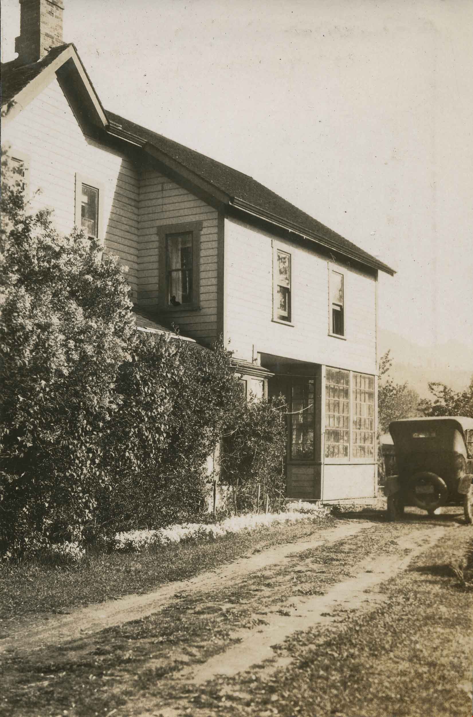
![Looking east from north side of 5118 Douglas Road - The Roberts House, [between 1924 and 1925] thumbnail](/media/hpo/_Data/_Archives_Images/_Unrestricted/600/620-003.jpg?width=280)
Looking east from north side of 5118 Douglas Road - The Roberts House
https://search.heritageburnaby.ca/link/archivedescription91822
- Repository
- City of Burnaby Archives
- Date
- [between 1924 and 1925]
- Collection/Fonds
- Small family fonds
- Description Level
- Item
- Physical Description
- 1 photograph : sepia ; 9 cm x 9 cm
- Scope and Content
- Photograph of Lauretta Roberts standing next to the half-built Roberts' house located at 5118 Douglas Road. During construction of the house, movie posters were used in place of tar paper under the exterior cedar shingles and as cushioning under the linoleum kitchen floor. Visible in the distance …
- Repository
- City of Burnaby Archives
- Date
- [between 1924 and 1925]
- Collection/Fonds
- Small family fonds
- Physical Description
- 1 photograph : sepia ; 9 cm x 9 cm
- Description Level
- Item
- Record No.
- 620-003
- Access Restriction
- No restrictions
- Reproduction Restriction
- No restrictions
- Accession Number
- 2017-01
- Scope and Content
- Photograph of Lauretta Roberts standing next to the half-built Roberts' house located at 5118 Douglas Road. During construction of the house, movie posters were used in place of tar paper under the exterior cedar shingles and as cushioning under the linoleum kitchen floor. Visible in the distance is the Adams' family house located on the 5100 block of Douglas Road.
- Media Type
- Photograph
- Notes
- Transcribed title
- Title transcribed from donor's notes
- 5118 Douglas Road renumbered to 3131 Douglas Road in 1958 and to 5538 Dominion Street in 1970 or 1971
- The new address house in the background of the photograph is 3011 Godwin Street
- Note in black ink on verso of photograph reads: "Probably 1924-25 / Lauretta Roberts"
- Note in blue ink on verso of photograph reads: "P4"
- Street Address
- 3131 Douglas Road
- 5118 Douglas Road
- 5538 Dominion Street
- 3011 Godwin Avenue
- Historic Neighbourhood
- Burnaby Lake (Historic Neighbourhood)
- Planning Study Area
- Ardingley-Sprott Area
Images
![Looking east from north side of 5118 Douglas Road - The Roberts House, [between 1924 and 1925] thumbnail](/media/hpo/_Data/_Archives_Images/_Unrestricted/600/620-003.jpg)

Close up of front of Roberts' house 5118 Douglas Road
https://search.heritageburnaby.ca/link/archivedescription91836
- Repository
- City of Burnaby Archives
- Date
- 1927
- Collection/Fonds
- Small family fonds
- Description Level
- Item
- Physical Description
- 1 photograph : sepia ; 10 cm x 6 cm
- Scope and Content
- Photograph of John W. and Mary Roberts (pregnant with son Roland) and their son Edward Roberts standing in front of their house at 5118 Douglas Road. The front steps and porch of the house are complete, but the pillars and sidewalk are not yet in place. In the background is the framework for nett…
- Repository
- City of Burnaby Archives
- Date
- 1927
- Collection/Fonds
- Small family fonds
- Physical Description
- 1 photograph : sepia ; 10 cm x 6 cm
- Description Level
- Item
- Record No.
- 620-017
- Access Restriction
- No restrictions
- Reproduction Restriction
- No known restrictions
- Accession Number
- 2017-01
- Scope and Content
- Photograph of John W. and Mary Roberts (pregnant with son Roland) and their son Edward Roberts standing in front of their house at 5118 Douglas Road. The front steps and porch of the house are complete, but the pillars and sidewalk are not yet in place. In the background is the framework for netting around the property's tennis court. To the right is Douglas Road, where the Roberts' mailbox and a car are visible in the distance.
- Media Type
- Photograph
- Notes
- Transcribed title
- Title transcribed from donor's notes
- Note in black ink on verso of photograph reads: "Aug, 1927 / Mother, father and Teddy / Please return"
- Note in black ink on verso of photograph reads: "How's this John?"
- Stamp on verso of photograph read: "56"
- Note in blue ink on verso of photograph reads: "P.17"
- 5118 Douglas Road renumbered to 3131 Douglas Road in 1958 and to 5538 Dominion Street in 1970 or 1971
- Street Address
- 3131 Douglas Road
- 5118 Douglas Road
- 5538 Dominion Street
- Historic Neighbourhood
- Burnaby Lake (Historic Neighbourhood)
- Planning Study Area
- Ardingley-Sprott Area
Images
![Stride family home, [between 1915 and 1920] thumbnail](/media/hpo/_Data/_Archives_Images/_Unrestricted/001/001-001.jpg?width=280)
Stride family home
https://search.heritageburnaby.ca/link/archivedescription34025
- Repository
- City of Burnaby Archives
- Date
- [between 1915 and 1920]
- Collection/Fonds
- Burnaby Historical Society fonds
- Description Level
- Item
- Physical Description
- 1 photograph : sepia postcard ; 8 x 14 cm
- Scope and Content
- Photographic postcard of the exterior of the Stride family home located at Kingsway and 18th Avenue. Two people are traveling in a Model T Ford (with the top down) along the street in front of the house.
- Repository
- City of Burnaby Archives
- Date
- [between 1915 and 1920]
- Collection/Fonds
- Burnaby Historical Society fonds
- Subseries
- Stride family subseries
- Physical Description
- 1 photograph : sepia postcard ; 8 x 14 cm
- Description Level
- Item
- Record No.
- 001-001
- Access Restriction
- No restrictions
- Reproduction Restriction
- No known restrictions
- Accession Number
- BHS2007-04
- Scope and Content
- Photographic postcard of the exterior of the Stride family home located at Kingsway and 18th Avenue. Two people are traveling in a Model T Ford (with the top down) along the street in front of the house.
- Subjects
- Buildings - Residential - Houses
- Documentary Artifacts - Postcards
- Transportation - Automobiles
- Media Type
- Photograph
- Notes
- Title based on contents of photograph
- Geographic Access
- Kingsway
- 18th Avenue
- Historic Neighbourhood
- Edmonds (Historic Neighbourhood)
Images
![Stride family home, [between 1915 and 1920] thumbnail](/media/hpo/_Data/_Archives_Images/_Unrestricted/001/001-001.jpg)
![Stride family house, [1920] thumbnail](/media/hpo/_Data/_Archives_Images/_Unrestricted/001/001-002.jpg?width=280)
Stride family house
https://search.heritageburnaby.ca/link/archivedescription34026
- Repository
- City of Burnaby Archives
- Date
- [1920]
- Collection/Fonds
- Burnaby Historical Society fonds
- Description Level
- Item
- Physical Description
- 1 photograph : sepia ; 7.5 x 10.1 cm
- Scope and Content
- Photograph of the Stride family house located at Kingsway and 18th Avenue.
- Repository
- City of Burnaby Archives
- Date
- [1920]
- Collection/Fonds
- Burnaby Historical Society fonds
- Subseries
- Stride family subseries
- Physical Description
- 1 photograph : sepia ; 7.5 x 10.1 cm
- Description Level
- Item
- Record No.
- 001-002
- Access Restriction
- No restrictions
- Reproduction Restriction
- No known restrictions
- Accession Number
- BHS2007-04
- Scope and Content
- Photograph of the Stride family house located at Kingsway and 18th Avenue.
- Subjects
- Buildings - Residential - Houses
- Media Type
- Photograph
- Notes
- Title based on contents of photograph
- Geographic Access
- Kingsway
- 18th Avenue
- Historic Neighbourhood
- Edmonds (Historic Neighbourhood)
Images
![Stride family house, [1920] thumbnail](/media/hpo/_Data/_Archives_Images/_Unrestricted/001/001-002.jpg)
![Stride family house, [1920] thumbnail](/media/hpo/_Data/_Archives_Images/_Unrestricted/001/001-003.jpg?width=280)
Stride family house
https://search.heritageburnaby.ca/link/archivedescription34027
- Repository
- City of Burnaby Archives
- Date
- [1920]
- Collection/Fonds
- Burnaby Historical Society fonds
- Description Level
- Item
- Physical Description
- 1 photograph : b&w ; 8.2 x 10.8 cm
- Scope and Content
- Photograph of the Stride family house located at Kingsway and 18th Avenue. It is obscured by trees in blossom.
- Repository
- City of Burnaby Archives
- Date
- [1920]
- Collection/Fonds
- Burnaby Historical Society fonds
- Subseries
- Stride family subseries
- Physical Description
- 1 photograph : b&w ; 8.2 x 10.8 cm
- Description Level
- Item
- Record No.
- 001-003
- Access Restriction
- No restrictions
- Reproduction Restriction
- No known restrictions
- Accession Number
- BHS2007-04
- Scope and Content
- Photograph of the Stride family house located at Kingsway and 18th Avenue. It is obscured by trees in blossom.
- Media Type
- Photograph
- Notes
- Title based on contents of photograph
- Geographic Access
- Kingsway
- 18th Avenue
- Historic Neighbourhood
- Edmonds (Historic Neighbourhood)
Images
![Stride family house, [1920] thumbnail](/media/hpo/_Data/_Archives_Images/_Unrestricted/001/001-003.jpg)

Deer Lake
https://search.heritageburnaby.ca/link/archivedescription34296
- Repository
- City of Burnaby Archives
- Date
- 1923
- Collection/Fonds
- Burnaby Historical Society fonds
- Description Level
- Item
- Physical Description
- 1 photograph : sepia ; 8 x 13.2 cm on page 17.5 x 24.8 cm
- Scope and Content
- Photograph looking over Deer Lake and snow-covered ground towards the Frederick and Alice Hart mansion known as the Avalon Estate. In the foreground the Hart's cottage is visible; it was built near Deer Lake in 1904 as a summer retreat for the Hart family. Eventually, the family decided to reside a…
- Repository
- City of Burnaby Archives
- Date
- 1923
- Collection/Fonds
- Burnaby Historical Society fonds
- Subseries
- Peers family subseries
- Physical Description
- 1 photograph : sepia ; 8 x 13.2 cm on page 17.5 x 24.8 cm
- Description Level
- Item
- Record No.
- 020-003
- Access Restriction
- No restrictions
- Reproduction Restriction
- No known restrictions
- Accession Number
- BHS2007-04
- Scope and Content
- Photograph looking over Deer Lake and snow-covered ground towards the Frederick and Alice Hart mansion known as the Avalon Estate. In the foreground the Hart's cottage is visible; it was built near Deer Lake in 1904 as a summer retreat for the Hart family. Eventually, the family decided to reside at Deer Lake year-round and began building the large estate which is visible in the centre of the photograph. In 1917, Mr. and Mrs. Hart were devastated when their son, Kingsley was killed in World War I and so they sold Avalon to Montague and Ethel Moore. The Moore's continued with improvements to the estate and renamed it Rosedale Gardens. Just to the right of the estate can be seen a home at 5140 Sperling Avenue which later became the Gayton house. To the right of that, what was originally the cottage belonging to Harriet and Maude Woodward is visible. At the time of this photograph, the cottage was being used as the Burnaby Lake United Church.
- Subjects
- Buildings - Heritage
- Buildings - Residential - Houses
- Geographic Features - Lakes and Ponds
- Media Type
- Photograph
- Notes
- Title based on caption accompanying photograph
- Geographic Access
- Deer Lake Avenue
- Deer Lake
- Sperling Avenue
- Street Address
- 6664 Deer Lake Avenue
- 5141 Sperling Avenue
- 5140 Sperling Avenue
- Historic Neighbourhood
- Burnaby Lake (Historic Neighbourhood)
- Planning Study Area
- Morley-Buckingham Area
Images


Deer Lake
https://search.heritageburnaby.ca/link/archivedescription34297
- Repository
- City of Burnaby Archives
- Date
- 1923
- Collection/Fonds
- Burnaby Historical Society fonds
- Description Level
- Item
- Physical Description
- 1 photograph : sepia
- Scope and Content
- Photograph looking over Deer Lake and snow-covered ground towards buildings and houses. To the left is the cottage and house belonging to the Woodward sisters, Harriet and Maude. The cottage, and later the house, were also used as the Burnaby Lake Post Office and a school run by Harriet Woodward. …
- Repository
- City of Burnaby Archives
- Date
- 1923
- Collection/Fonds
- Burnaby Historical Society fonds
- Subseries
- Peers family subseries
- Physical Description
- 1 photograph : sepia
- Description Level
- Item
- Record No.
- 020-004
- Access Restriction
- No restrictions
- Reproduction Restriction
- No known restrictions
- Accession Number
- BHS2007-04
- Scope and Content
- Photograph looking over Deer Lake and snow-covered ground towards buildings and houses. To the left is the cottage and house belonging to the Woodward sisters, Harriet and Maude. The cottage, and later the house, were also used as the Burnaby Lake Post Office and a school run by Harriet Woodward. At the time of this photograph, it was in use as the Burnaby Lake United Church. In the middle of the picture, numerous boathouses and a diving tower can be seen at the shoreline of the lake. To the right of the copse of trees, on the hill, is the house and post office belonging to the Woodward sisters and right of that is the home built for William J. Walker in 1907 but owned by D.R. Boucher during the 1920s. To the far right the Pole Line Road (later, Sperling Avenue) is visible along with the home of Francis J. Peers, known as Greyfriars.
- Subjects
- Buildings - Heritage
- Buildings - Residential - Houses
- Geographic Features - Lakes and Ponds
- Buildings - Religious - Churches
- Media Type
- Photograph
- Notes
- Title based on caption accompanying photograph
- Geographic Access
- Sperling Avenue
- Deer Lake
- Rugby Street
- Historic Neighbourhood
- Burnaby Lake (Historic Neighbourhood)
- Planning Study Area
- Morley-Buckingham Area
Images


Dyke construction on Nicomen Island
https://search.heritageburnaby.ca/link/archivedescription34331
- Repository
- City of Burnaby Archives
- Date
- 1927
- Collection/Fonds
- Burnaby Historical Society fonds
- Description Level
- Item
- Physical Description
- 1 photograph : sepia ; 7 x 13.5 cm on page 17.5 x 22.7 cm
- Scope and Content
- Photograph of a home, with car in the foreground next to equipment being used in the construction of dykes on Nicomen Island.
- Repository
- City of Burnaby Archives
- Date
- 1927
- Collection/Fonds
- Burnaby Historical Society fonds
- Subseries
- Peers family subseries
- Physical Description
- 1 photograph : sepia ; 7 x 13.5 cm on page 17.5 x 22.7 cm
- Description Level
- Item
- Record No.
- 020-038
- Access Restriction
- No restrictions
- Reproduction Restriction
- No known restrictions
- Accession Number
- BHS2007-04
- Scope and Content
- Photograph of a home, with car in the foreground next to equipment being used in the construction of dykes on Nicomen Island.
- Subjects
- Construction Tools and Equipment
- Geographic Features - Dykes
- Buildings - Residential - Houses
- Media Type
- Photograph
- Notes
- Title based on caption accompanying photograph
Images

Llanmaes
https://search.heritageburnaby.ca/link/archivedescription34394
- Repository
- City of Burnaby Archives
- Date
- 1926
- Collection/Fonds
- Burnaby Historical Society fonds
- Description Level
- Item
- Physical Description
- 1 photograph : b&w ; 7 x 10.5 cm on page 17.4 x 26.4 cm
- Scope and Content
- Photograph of a home identified as "Llanmaes" in Sardis, British Columbia. A car is parked in the driveway next to the house. This photograph appears to have been taken by Arthur Peers, who travelled through the Fraser River Valley and worked on the construction of the Trans-Provincial Highway duri…
- Repository
- City of Burnaby Archives
- Date
- 1926
- Collection/Fonds
- Burnaby Historical Society fonds
- Subseries
- Peers family subseries
- Physical Description
- 1 photograph : b&w ; 7 x 10.5 cm on page 17.4 x 26.4 cm
- Description Level
- Item
- Record No.
- 020-101
- Access Restriction
- No restrictions
- Reproduction Restriction
- No known restrictions
- Accession Number
- BHS2007-04
- Scope and Content
- Photograph of a home identified as "Llanmaes" in Sardis, British Columbia. A car is parked in the driveway next to the house. This photograph appears to have been taken by Arthur Peers, who travelled through the Fraser River Valley and worked on the construction of the Trans-Provincial Highway during the later 1920s.
- Subjects
- Buildings - Residential - Houses
- Media Type
- Photograph
- Photographer
- Peers, Arthur Francis "Mike"
- Notes
- Title based on caption accompanying photograph
Images

Moxham family house
https://search.heritageburnaby.ca/link/archivedescription34818
- Repository
- City of Burnaby Archives
- Date
- 1929
- Collection/Fonds
- Burnaby Historical Society fonds
- Description Level
- Item
- Physical Description
- 1 photograph : b&w ; 7.0 x 11.5 cm
- Scope and Content
- Photograph of the exterior of the Moxham family house at 1944 6th Street (later renumbered 7337 6th Street). This house was built in 1914 by Mr. Godfrey Moxham.
- Repository
- City of Burnaby Archives
- Date
- 1929
- Collection/Fonds
- Burnaby Historical Society fonds
- Subseries
- Kathleen Moore family subseries
- Physical Description
- 1 photograph : b&w ; 7.0 x 11.5 cm
- Description Level
- Item
- Record No.
- 139-001
- Access Restriction
- No restrictions
- Reproduction Restriction
- No known restrictions
- Accession Number
- BHS1985-09
- Scope and Content
- Photograph of the exterior of the Moxham family house at 1944 6th Street (later renumbered 7337 6th Street). This house was built in 1914 by Mr. Godfrey Moxham.
- Subjects
- Buildings - Residential - Houses
- Media Type
- Photograph
- Notes
- Title based on contents of photograph
- Geographic Access
- 6th Street
- Street Address
- 7337 6th Street
- Historic Neighbourhood
- East Burnaby (Historic Neighbourhood)
- Planning Study Area
- Edmonds Area
Images

![Forster family house and store, [1924] (date of original), copied 1986 thumbnail](/media/hpo/_Data/_Archives_Images/_Unrestricted/126/168-007.jpg?width=280)
Forster family house and store
https://search.heritageburnaby.ca/link/archivedescription34972
- Repository
- City of Burnaby Archives
- Date
- [1924] (date of original), copied 1986
- Collection/Fonds
- Burnaby Historical Society fonds
- Description Level
- Item
- Physical Description
- 1 photograph : b&w ; 12.5 x 8.8 cm print
- Scope and Content
- Photograph of Wilson Forster's plumbing and electrical business and the Forster family home at 2849 McKay Avenue (later renumbered 6208 McKay Avenue).
- Repository
- City of Burnaby Archives
- Date
- [1924] (date of original), copied 1986
- Collection/Fonds
- Burnaby Historical Society fonds
- Subseries
- Forster family subseries
- Physical Description
- 1 photograph : b&w ; 12.5 x 8.8 cm print
- Description Level
- Item
- Record No.
- 168-007
- Access Restriction
- No restrictions
- Reproduction Restriction
- No known restrictions
- Accession Number
- BHS1986-17
- Scope and Content
- Photograph of Wilson Forster's plumbing and electrical business and the Forster family home at 2849 McKay Avenue (later renumbered 6208 McKay Avenue).
- Media Type
- Photograph
- Notes
- Title based on contents of photograph
- Geographic Access
- McKay Avenue
- Street Address
- 6208 McKay Avenue
- Historic Neighbourhood
- Central Park (Historic Neighbourhood)
- Planning Study Area
- Maywood Area
Images
![Forster family house and store, [1924] (date of original), copied 1986 thumbnail](/media/hpo/_Data/_Archives_Images/_Unrestricted/126/168-007.jpg)
![Elgin Avenue farmhouse, [between 1920 and 1925] (date of original), copied 1986 thumbnail](/media/hpo/_Data/_Archives_Images/_Unrestricted/126/179-005.jpg?width=280)
Elgin Avenue farmhouse
https://search.heritageburnaby.ca/link/archivedescription35034
- Repository
- City of Burnaby Archives
- Date
- [between 1920 and 1925] (date of original), copied 1986
- Collection/Fonds
- Burnaby Historical Society fonds
- Description Level
- Item
- Physical Description
- 1 photograph : b&w ; 8.7 x 12.7 cm print
- Scope and Content
- Photograph of the exterior of an Elgin Avenue farmhouse and surrounding property. The farmhouse is at the left side of the photograph, and a chicken barn is at the right side. This may be 6389 Elgin Avenue.
- Repository
- City of Burnaby Archives
- Date
- [between 1920 and 1925] (date of original), copied 1986
- Collection/Fonds
- Burnaby Historical Society fonds
- Subseries
- Chamberlain family subseries
- Physical Description
- 1 photograph : b&w ; 8.7 x 12.7 cm print
- Description Level
- Item
- Record No.
- 179-005
- Access Restriction
- No restrictions
- Reproduction Restriction
- No known restrictions
- Accession Number
- BHS1986-27
- Scope and Content
- Photograph of the exterior of an Elgin Avenue farmhouse and surrounding property. The farmhouse is at the left side of the photograph, and a chicken barn is at the right side. This may be 6389 Elgin Avenue.
- Media Type
- Photograph
- Notes
- Title based on contents of photograph
- Geographic Access
- Elgin Avenue
- Street Address
- 6389 Elgin Avenue
- Historic Neighbourhood
- Central Park (Historic Neighbourhood)
- Planning Study Area
- Windsor Area
Images
![Elgin Avenue farmhouse, [between 1920 and 1925] (date of original), copied 1986 thumbnail](/media/hpo/_Data/_Archives_Images/_Unrestricted/126/179-005.jpg)
![Vancouver Heights, [1921] (date of original), copied 1986 thumbnail](/media/hpo/_Data/_Archives_Images/_Unrestricted/204/204-302.jpg?width=280)
Vancouver Heights
https://search.heritageburnaby.ca/link/archivedescription35444
- Repository
- City of Burnaby Archives
- Date
- [1921] (date of original), copied 1986
- Collection/Fonds
- Burnaby Historical Society fonds
- Description Level
- Item
- Physical Description
- 1 photograph : b&w ; 12.7 x 17.8 cm print
- Scope and Content
- Photograph of the Vancouver Heights area, with Burrard Inlet in background, taken from Triumph Street and Esmond Avenue looking northwest. In the centre of the photograph is the Wilks house at 3707 Dundas Street, with the light-coloured house in the middle being 3738 Dundas Street.
- Repository
- City of Burnaby Archives
- Date
- [1921] (date of original), copied 1986
- Collection/Fonds
- Burnaby Historical Society fonds
- Subseries
- Pioneer Tales subseries
- Physical Description
- 1 photograph : b&w ; 12.7 x 17.8 cm print
- Description Level
- Item
- Record No.
- 204-302
- Access Restriction
- No restrictions
- Reproduction Restriction
- No known restrictions
- Accession Number
- BHS1988-03
- Scope and Content
- Photograph of the Vancouver Heights area, with Burrard Inlet in background, taken from Triumph Street and Esmond Avenue looking northwest. In the centre of the photograph is the Wilks house at 3707 Dundas Street, with the light-coloured house in the middle being 3738 Dundas Street.
- Subjects
- Buildings - Residential - Houses
- Media Type
- Photograph
- Notes
- Title based on contents of photograph
- Annotation under photograph reads, "Vancouver Hts & Burrard Inlet / 1921"
- Geographic Access
- Triumph Street
- Dundas Street
- Esmond Avenue
- Street Address
- 3707 Dundas Street
- 3738 Dundas Street
- Historic Neighbourhood
- Vancouver Heights (Historic Neighbourhood)
- Planning Study Area
- Burnaby Heights Area
Images
![Vancouver Heights, [1921] (date of original), copied 1986 thumbnail](/media/hpo/_Data/_Archives_Images/_Unrestricted/204/204-302.jpg)
Phillips family home
https://search.heritageburnaby.ca/link/archivedescription35461
- Repository
- City of Burnaby Archives
- Date
- 1929 (date of original), copied 1986
- Collection/Fonds
- Burnaby Historical Society fonds
- Description Level
- Item
- Physical Description
- 1 photograph : b&w ; 12.7 x 17.8 cm print
- Scope and Content
- Photograph of the Phillips family home at 5670 Byrne Road, built in 1929. This was the home of John Phillips, his wife Lily Phillips (nee Warne) and their children. They owned and operated a large dairy (Victory Dairy). The dairy and cow barns were also on this property.
- Repository
- City of Burnaby Archives
- Date
- 1929 (date of original), copied 1986
- Collection/Fonds
- Burnaby Historical Society fonds
- Subseries
- Pioneer Tales subseries
- Physical Description
- 1 photograph : b&w ; 12.7 x 17.8 cm print
- Description Level
- Item
- Record No.
- 204-319
- Access Restriction
- No restrictions
- Reproduction Restriction
- No known restrictions
- Accession Number
- BHS1988-03
- Scope and Content
- Photograph of the Phillips family home at 5670 Byrne Road, built in 1929. This was the home of John Phillips, his wife Lily Phillips (nee Warne) and their children. They owned and operated a large dairy (Victory Dairy). The dairy and cow barns were also on this property.
- Subjects
- Buildings - Residential - Houses
- Media Type
- Photograph
- Notes
- Title based on contents of photograph
- Geographic Access
- Byrne Road
- Street Address
- 5670 Byrne Road
- Historic Neighbourhood
- Fraser Arm (Historic Neighbourhood)
- Planning Study Area
- Big Bend Area
Images
