Narrow Results By
Person / Organization
- All Saints Anglican Church 2
- Broadview Presbyterian Church 1
- Burton, John 1
- Central Park Presbyterian Church 1
- Christ the King Seminary 2
- Dundonald United Church 3
- Gordon Presbyterian Church 1
- Grace Tabernacle Church 1
- Matheson, John 1
- Riverway East School 2
- Riverway West Baptist Mission 1
- St. Alban's Anglican Church 6

Edmonds Baptist Church
https://search.heritageburnaby.ca/link/landmark575
- Repository
- Burnaby Heritage Planning
- Description
- Church building.
- Associated Dates
- 1912
- Street View URL
- Google Maps Street View
- Repository
- Burnaby Heritage Planning
- Geographic Access
- Walker Avenue
- Associated Dates
- 1912
- Description
- Church building.
- Heritage Value
- Beautifully designed in an Arts and Crafts idiom, this church features a textural mix of finishes including lapped siding and stucco and half timbering in the gables. The British Columbian reported in July 1912 that: "The Baptists of Edmonds will possess a fine and well planned church when the building now commenced is ready for occupation. The architects are J.P. Matheson and Son, of Vancouver, and the contractors, Muttitt and Bell, of New Westminster. The entrance porch fronts Edmonds Road and the west side faces Vancouver Road. It will have a capacity for 272 sittings, spacious aisles and choir platform besides various rooms for Baptistery, vestry and robing apartments."
- Locality
- Edmonds
- Historic Neighbourhood
- Edmonds (Historic Neighbourhood)
- Planning Study Area
- Richmond Park Area
- Architect
- J.P. Matheson & Son
- Builder
- Muttitt and Bell
- Area
- 1471.58
- Contributing Resource
- Building
- Ownership
- Private
- Names
- Matheson, John
- Street Address
- 7135 Walker Avenue
- Street View URL
- Google Maps Street View
Images


![All Saints Anglican Church and Parish Hall, [191-] thumbnail](/media/hpo/_Data/_BVM_Images/1977/198000120004.jpg?width=280)
All Saints Anglican Church and Parish Hall
https://search.heritageburnaby.ca/link/museumdescription3032
- Repository
- Burnaby Village Museum
- Date
- [191-]
- Collection/Fonds
- Burnaby Village Museum Photograph collection
- Description Level
- Item
- Physical Description
- 1 photograph : b&w postcard ; 8.8 x 13.9 cm
- Scope and Content
- Photographic postcard of two buildings identified as All Saints Anglican Church and Parish Hall. There are two men in work clothes (cover-alls) standing in between the two buildings. There is a ladder going up to the roof of one building.
- Repository
- Burnaby Village Museum
- Collection/Fonds
- Burnaby Village Museum Photograph collection
- Description Level
- Item
- Physical Description
- 1 photograph : b&w postcard ; 8.8 x 13.9 cm
- Scope and Content
- Photographic postcard of two buildings identified as All Saints Anglican Church and Parish Hall. There are two men in work clothes (cover-alls) standing in between the two buildings. There is a ladder going up to the roof of one building.
- Geographic Access
- Royal Oak Avenue
- Street Address
- 7405 Royal Oak Avenue
- Accession Code
- HV980.12.4
- Access Restriction
- No restrictions
- Reproduction Restriction
- May be restricted by third party rights
- Date
- [191-]
- Media Type
- Photograph
- Historic Neighbourhood
- Alta-Vista (Historic Neighbourhood)
- Planning Study Area
- Sussex-Nelson Area
- Scan Resolution
- 600
- Scan Date
- 2023-09-12
- Notes
- Title based on contents of photograph
Images
![All Saints Anglican Church and Parish Hall, [191-] thumbnail](/media/hpo/_Data/_BVM_Images/1977/198000120004.jpg)
![All Saints Church, [ca.1910] thumbnail](/media/hpo/_Data/_BVM_Cartographic_Material/2003/2003_0083_0046_001.jpg?width=280)
All Saints Church
https://search.heritageburnaby.ca/link/museumdescription11924
- Repository
- Burnaby Village Museum
- Date
- [ca.1910]
- Collection/Fonds
- Ronald G. Scobbie collection
- Description Level
- Item
- Physical Description
- 1 plan : black ink and watercol. on paper ; 30.45 x 30.5 cm
- Scope and Content
- Item consists of building insurance plan of "All Saints Church / Lot "A" BK 29 DL 98 GP1 N.W.D.". Watling Street is idenfied to the north of the church building and Royal Oak Avenue to the west.
- Repository
- Burnaby Village Museum
- Collection/Fonds
- Ronald G. Scobbie collection
- Description Level
- Item
- Physical Description
- 1 plan : black ink and watercol. on paper ; 30.45 x 30.5 cm
- Material Details
- Scale 1 inch = 20 feet
- Scope and Content
- Item consists of building insurance plan of "All Saints Church / Lot "A" BK 29 DL 98 GP1 N.W.D.". Watling Street is idenfied to the north of the church building and Royal Oak Avenue to the west.
- Subjects
- Buildings - Religious - Churches
- Accession Code
- BV003.83.46
- Access Restriction
- No restrictions
- Reproduction Restriction
- No known restrictions
- Date
- [ca.1910]
- Media Type
- Cartographic Material
- Scan Resolution
- 600
- Scan Date
- 15-Jan-2021
- Scale
- 100
- Notes
- Transcribed title
- Note in pencil on verso reads: ""All Saints Church / Lot "A" BK 29 DL 98 / Scale 1 inch = 20 feet"
- Note in balck in on verso reads: "3704"
Images
![All Saints Church, [ca.1910] thumbnail](/media/hpo/_Data/_BVM_Cartographic_Material/2003/2003_0083_0046_001.jpg)
![Anglican Church, [ca.1910] thumbnail](/media/hpo/_Data/_BVM_Cartographic_Material/2003/2003_0083_0043_001.jpg?width=280)
Anglican Church
https://search.heritageburnaby.ca/link/museumdescription11921
- Repository
- Burnaby Village Museum
- Date
- [ca.1910]
- Collection/Fonds
- Ronald G. Scobbie collection
- Description Level
- Item
- Physical Description
- 1 plan : black ink and watercol. on paper ; 30.45 x 30.5 cm
- Scope and Content
- Item consists of building insurance plan of "Anglican Church / Lot 2 BK 37 DL69, GP.1, N.W.D. (15th Ave. (Dominion) is identified to the north of Lots 1, 2 and 3).
- Repository
- Burnaby Village Museum
- Collection/Fonds
- Ronald G. Scobbie collection
- Description Level
- Item
- Physical Description
- 1 plan : black ink and watercol. on paper ; 30.45 x 30.5 cm
- Material Details
- Scale 1 inch = 20 feet
- Scope and Content
- Item consists of building insurance plan of "Anglican Church / Lot 2 BK 37 DL69, GP.1, N.W.D. (15th Ave. (Dominion) is identified to the north of Lots 1, 2 and 3).
- Subjects
- Buildings - Religious - Churches
- Accession Code
- BV003.83.43
- Access Restriction
- No restrictions
- Reproduction Restriction
- No known restrictions
- Date
- [ca.1910]
- Media Type
- Cartographic Material
- Scan Resolution
- 600
- Scan Date
- 15-Jan-2021
- Scale
- 100
- Notes
- Transcribed title
- Note in pencil on verso reads: "Anglican Church / Lot 2 Bk 37 DL69 / 1"=20' "
- Note in balck in on verso reads: "3704"
Images
![Anglican Church, [ca.1910] thumbnail](/media/hpo/_Data/_BVM_Cartographic_Material/2003/2003_0083_0043_001.jpg)
![Broadview Presbyterian Church, [ca.1910] thumbnail](/media/hpo/_Data/_BVM_Cartographic_Material/2003/2003_0083_0049_001.jpg?width=280)
Broadview Presbyterian Church
https://search.heritageburnaby.ca/link/museumdescription11927
- Repository
- Burnaby Village Museum
- Date
- [ca.1910]
- Collection/Fonds
- Ronald G. Scobbie collection
- Description Level
- Item
- Physical Description
- 1 plan : black ink and watercol. on paper ; 30.45 x 30.5 cm
- Scope and Content
- Item consists of building insurance plan of "Broadview Presbyterian Church / Lot 6, BK 31, DL 69 / GP1 N.W.D." . Fourteenth Avenue (Manor) is identified to the north and Douglas Ave. to the east.
- Repository
- Burnaby Village Museum
- Collection/Fonds
- Ronald G. Scobbie collection
- Description Level
- Item
- Physical Description
- 1 plan : black ink and watercol. on paper ; 30.45 x 30.5 cm
- Material Details
- Scale 1 inch = 20 feet
- Scope and Content
- Item consists of building insurance plan of "Broadview Presbyterian Church / Lot 6, BK 31, DL 69 / GP1 N.W.D." . Fourteenth Avenue (Manor) is identified to the north and Douglas Ave. to the east.
- Subjects
- Buildings - Religious - Churches
- Accession Code
- BV003.83.49
- Access Restriction
- No restrictions
- Reproduction Restriction
- No known restrictions
- Date
- [ca.1910]
- Media Type
- Cartographic Material
- Scan Resolution
- 600
- Scan Date
- 15-Jan-2021
- Scale
- 100
- Notes
- Transcribed title
- Note in pencil on verso reads: "Broadview Presbyterian Church / Lot 6, BK 31, DL 69 / 1" = 20' "
- Note in balck in on verso reads: "3704"
Images
![Broadview Presbyterian Church, [ca.1910] thumbnail](/media/hpo/_Data/_BVM_Cartographic_Material/2003/2003_0083_0049_001.jpg)

Central Park Presbyterian Church
https://search.heritageburnaby.ca/link/archivedescription36672
- Repository
- City of Burnaby Archives
- Date
- 1912 (date of original), copied 1992
- Collection/Fonds
- Burnaby Historical Society fonds
- Description Level
- Item
- Physical Description
- 1 photograph : b&w ; 10.1 x 14.9 cm print
- Scope and Content
- Photograph of Central Park Presbyterian Church and the surrounding area. The church was located on Westminster Road (later Kingsway) across from Central Park.
- Repository
- City of Burnaby Archives
- Date
- 1912 (date of original), copied 1992
- Collection/Fonds
- Burnaby Historical Society fonds
- Subseries
- Burnaby Centennial Anthology subseries
- Physical Description
- 1 photograph : b&w ; 10.1 x 14.9 cm print
- Description Level
- Item
- Record No.
- 315-027
- Access Restriction
- No restrictions
- Reproduction Restriction
- No known restrictions
- Accession Number
- BHS1994-04
- Scope and Content
- Photograph of Central Park Presbyterian Church and the surrounding area. The church was located on Westminster Road (later Kingsway) across from Central Park.
- Media Type
- Photograph
- Geographic Access
- Westminster Avenue
- Kingsway
- Street Address
- 3777 Kingsway
- Historic Neighbourhood
- Central Park (Historic Neighbourhood)
- Planning Study Area
- Garden Village Area
Images

![Chapel at Fairacres, [between 1939 and 1954] thumbnail](/media/hpo/_Data/_Archives_Images/_Unrestricted/205/242-001.jpg?width=280)
Chapel at Fairacres
https://search.heritageburnaby.ca/link/archivedescription36251
- Repository
- City of Burnaby Archives
- Date
- [between 1939 and 1954]
- Collection/Fonds
- Burnaby Historical Society fonds
- Description Level
- Item
- Physical Description
- 1 photograph : b&w copy negative ; 3 x 4 cm
- Scope and Content
- Photograph of the chapel of the Order of St. Benedict at the Ceperley Mansion when they purchased and occupied the mansion from 1939 to 1954. They converted the drawing room into a chapel, placing the altar in front of the fireplace. A platform with a cross on a table. The letters "LOCUS ISTE SANCT…
- Repository
- City of Burnaby Archives
- Date
- [between 1939 and 1954]
- Collection/Fonds
- Burnaby Historical Society fonds
- Subseries
- Burnaby Art Gallery subseries
- Physical Description
- 1 photograph : b&w copy negative ; 3 x 4 cm
- Description Level
- Item
- Record No.
- 242-001
- Access Restriction
- No restrictions
- Reproduction Restriction
- No known restrictions
- Accession Number
- BHS1990-05
- Scope and Content
- Photograph of the chapel of the Order of St. Benedict at the Ceperley Mansion when they purchased and occupied the mansion from 1939 to 1954. They converted the drawing room into a chapel, placing the altar in front of the fireplace. A platform with a cross on a table. The letters "LOCUS ISTE SANCTUS EST" are inscribed on the wall above the cross. There is a picture of baby Jesus held by the Virgin Mary on one side of the platform, and a Saint holding a baby on the other.
- Names
- Westminster Priory
- Media Type
- Photograph
- Notes
- Title based on contents of photograph 1 b&w copy print accompanying
- Geographic Access
- Deer Lake Avenue
- Street Address
- 6344 Deer Lake Avenue
- Historic Neighbourhood
- Burnaby Lake (Historic Neighbourhood)
- Planning Study Area
- Douglas-Gilpin Area
Images
![Chapel at Fairacres, [between 1939 and 1954] thumbnail](/media/hpo/_Data/_Archives_Images/_Unrestricted/205/242-001.jpg)
![Chapel at Fairacres, [between 1939 and 1954] (date of original), copied 1979 thumbnail](/media/hpo/_Data/_BVM_Images/1979/1979_0034_0002_001.jpg?width=280)
Chapel at Fairacres
https://search.heritageburnaby.ca/link/museumdescription1629
- Repository
- Burnaby Village Museum
- Date
- [between 1939 and 1954] (date of original), copied 1979
- Collection/Fonds
- Burnaby Village Museum Photograph collection
- Description Level
- Item
- Physical Description
- 1 photograph : b&w ; 20.3 x 25.2 cm print
- Scope and Content
- Photograph of the chapel of the Order of St. Benedict at the Ceperley Mansion when they purchased and occupied the mansion from 1939 to 1954. They converted the drawing room into a chapel, placing the altar in front of the fireplace. A platform with a cross on a table. The letters "LOCUS ISTE SANCT…
- Repository
- Burnaby Village Museum
- Collection/Fonds
- Burnaby Village Museum Photograph collection
- Description Level
- Item
- Physical Description
- 1 photograph : b&w ; 20.3 x 25.2 cm print
- Scope and Content
- Photograph of the chapel of the Order of St. Benedict at the Ceperley Mansion when they purchased and occupied the mansion from 1939 to 1954. They converted the drawing room into a chapel, placing the altar in front of the fireplace. A platform with a cross on a table. The letters "LOCUS ISTE SANCTUS EST" are inscribed on the wall above the cross. There is a picture of baby Jesus held by the Virgin Mary on one side of the platform, and a Saint holding a baby on the other.
- Names
- Westminster Priory
- Geographic Access
- Deer Lake Avenue
- Street Address
- 6344 Deer Lake Avenue
- Accession Code
- HV979.34.2
- Access Restriction
- Restricted access
- Reproduction Restriction
- May be restricted by third party rights
- Date
- [between 1939 and 1954] (date of original), copied 1979
- Media Type
- Photograph
- Historic Neighbourhood
- Burnaby Lake (Historic Neighbourhood)
- Planning Study Area
- Douglas-Gilpin Area
- Scan Resolution
- 600
- Scan Date
- 2023-09-12
- Notes
- Title based on contents of photograph
Images
![Chapel at Fairacres, [between 1939 and 1954] (date of original), copied 1979 thumbnail](/media/hpo/_Data/_BVM_Images/1979/1979_0034_0002_001.jpg)
![Christ the King Seminary, [1939] (date of original), copied [2001] thumbnail](/media/hpo/_Data/_Archives_Images/_Unrestricted/371/416-003.jpg?width=280)
Christ the King Seminary
https://search.heritageburnaby.ca/link/archivedescription38356
- Repository
- City of Burnaby Archives
- Date
- [1939] (date of original), copied [2001]
- Collection/Fonds
- Burnaby Historical Society fonds
- Description Level
- Item
- Physical Description
- 1 photograph :b&w ; 20.5 x 25.5 cm print
- Scope and Content
- Photograph of the Robert and Bessie Anderson house at Deer Lake, which was built in 1912. In 1939, the house was purchased by the Benedictine Monks for use as part of the Seminary of Christ the King. In 1971, the house was purchased by Burnaby to be used as part of the Arts Centre and, in 1992, wa…
- Repository
- City of Burnaby Archives
- Date
- [1939] (date of original), copied [2001]
- Collection/Fonds
- Burnaby Historical Society fonds
- Subseries
- Municipal record subseries
- Physical Description
- 1 photograph :b&w ; 20.5 x 25.5 cm print
- Description Level
- Item
- Record No.
- 416-003
- Access Restriction
- No restrictions
- Reproduction Restriction
- No known restrictions
- Accession Number
- BHS2001-6
- Scope and Content
- Photograph of the Robert and Bessie Anderson house at Deer Lake, which was built in 1912. In 1939, the house was purchased by the Benedictine Monks for use as part of the Seminary of Christ the King. In 1971, the house was purchased by Burnaby to be used as part of the Arts Centre and, in 1992, was designated as a city heritage site.
- Names
- Christ the King Seminary
- Media Type
- Photograph
- Notes
- Title based on contents of photograph
- Geographic Access
- Deer Lake Avenue
- Historic Neighbourhood
- Burnaby Lake (Historic Neighbourhood)
- Planning Study Area
- Douglas-Gilpin Area
Images
![Christ the King Seminary, [1939] (date of original), copied [2001] thumbnail](/media/hpo/_Data/_Archives_Images/_Unrestricted/371/416-003.jpg)
![Christ the King Seminary, [1939] (date of original), copied [2001] thumbnail](/media/hpo/_Data/_Archives_Images/_Unrestricted/371/416-004.jpg?width=280)
Christ the King Seminary
https://search.heritageburnaby.ca/link/archivedescription38357
- Repository
- City of Burnaby Archives
- Date
- [1939] (date of original), copied [2001]
- Collection/Fonds
- Burnaby Historical Society fonds
- Description Level
- Item
- Physical Description
- 1 photograph : b&w ; 20.5 x 25.5 cm print
- Scope and Content
- Photograph of the Robert and Bessie Anderson house at Deer Lake, which was built in 1912. In 1939, the house was purchased by the Benedictine Monks for use as part of the Seminary of Christ the King. In 1971, the house was purchased by Burnaby to be used as part of the Arts Centre and, in 1992, wa…
- Repository
- City of Burnaby Archives
- Date
- [1939] (date of original), copied [2001]
- Collection/Fonds
- Burnaby Historical Society fonds
- Subseries
- Municipal record subseries
- Physical Description
- 1 photograph : b&w ; 20.5 x 25.5 cm print
- Description Level
- Item
- Record No.
- 416-004
- Access Restriction
- No restrictions
- Reproduction Restriction
- No known restrictions
- Accession Number
- BHS2001-6
- Scope and Content
- Photograph of the Robert and Bessie Anderson house at Deer Lake, which was built in 1912. In 1939, the house was purchased by the Benedictine Monks for use as part of the Seminary of Christ the King. In 1971, the house was purchased by Burnaby to be used as part of the Arts Centre and, in 1992, was designated as a city heritage site.
- Names
- Christ the King Seminary
- Media Type
- Photograph
- Notes
- Title based on contents of photograph
- Geographic Access
- Deer Lake Avenue
- Historic Neighbourhood
- Burnaby Lake (Historic Neighbourhood)
- Planning Study Area
- Douglas-Gilpin Area
Images
![Christ the King Seminary, [1939] (date of original), copied [2001] thumbnail](/media/hpo/_Data/_Archives_Images/_Unrestricted/371/416-004.jpg)
![Church building, [1910] thumbnail](/media/hpo/_Data/_BVM_Images/1973/1973_0110_0056_001.jpg?width=280)
Church building
https://search.heritageburnaby.ca/link/museumdescription1042
- Repository
- Burnaby Village Museum
- Date
- [1910]
- Collection/Fonds
- Burnaby Village Museum Photograph collection
- Description Level
- Item
- Physical Description
- 1 photograph : sepia
- Scope and Content
- Photograph of an unidentified church building. The inscription indicates that the building is in Los Gates, California.
- Repository
- Burnaby Village Museum
- Collection/Fonds
- Burnaby Village Museum Photograph collection
- Description Level
- Item
- Physical Description
- 1 photograph : sepia
- Material Details
- inscribed in pencil, verso, t. "Oha/ In Los Gates/ California"
- Scope and Content
- Photograph of an unidentified church building. The inscription indicates that the building is in Los Gates, California.
- Subjects
- Buildings - Religious - Churches
- Accession Code
- HV973.110.56
- Access Restriction
- No restrictions
- Reproduction Restriction
- No known restrictions
- Date
- [1910]
- Media Type
- Photograph
- Scan Resolution
- 600
- Scan Date
- 2023-05-30
- Notes
- Title based on contents of photograph
Images
![Church building, [1910] thumbnail](/media/hpo/_Data/_BVM_Images/1973/1973_0110_0056_001.jpg)
![Dundonald United Church, [between 1911 and 1919] thumbnail](/media/hpo/_Data/_Archives_Images/_Unrestricted/316/325-022.jpg?width=280)
Dundonald United Church
https://search.heritageburnaby.ca/link/archivedescription37150
- Repository
- City of Burnaby Archives
- Date
- [between 1911 and 1919]
- Collection/Fonds
- Burnaby Historical Society fonds
- Description Level
- Item
- Physical Description
- 1 photograph : b&w ; 8.5 x 12.5 cm print
- Scope and Content
- Photograph of Dundonald United Church, taken from the school grounds of Riverway East (later renamed Dundonald School).
- Repository
- City of Burnaby Archives
- Date
- [between 1911 and 1919]
- Collection/Fonds
- Burnaby Historical Society fonds
- Subseries
- Disney family subseries
- Physical Description
- 1 photograph : b&w ; 8.5 x 12.5 cm print
- Description Level
- Item
- Record No.
- 325-022
- Access Restriction
- No restrictions
- Reproduction Restriction
- No known restrictions
- Accession Number
- BHS1996-04
- Scope and Content
- Photograph of Dundonald United Church, taken from the school grounds of Riverway East (later renamed Dundonald School).
- Subjects
- Buildings - Religious - Churches
- Media Type
- Photograph
- Photographer
- Disney, John Harold "Jack"
- Notes
- Title based on contents of photograph
- Geographic Access
- Marine Drive
- Clinton Street
- Gilley Avenue
- Curragh Avenue
- Historic Neighbourhood
- Alta-Vista (Historic Neighbourhood)
- Planning Study Area
- Clinton-Glenwood Area
Images
![Dundonald United Church, [between 1911 and 1919] thumbnail](/media/hpo/_Data/_Archives_Images/_Unrestricted/316/325-022.jpg)
![Dundonald United Church, [ca.1910] thumbnail](/media/hpo/_Data/_BVM_Cartographic_Material/2003/2003_0083_0052_001.jpg?width=280)
Dundonald United Church
https://search.heritageburnaby.ca/link/museumdescription11930
- Repository
- Burnaby Village Museum
- Date
- [ca.1910]
- Collection/Fonds
- Ronald G. Scobbie collection
- Description Level
- Item
- Physical Description
- 1 plan : black ink and watercol. on paper ; 30.45 x 30.5 cm
- Scope and Content
- Item consists of a building insurance plan of "Dundonald United Church / Lots 9, 10 BK 28 DL 159 GP 1 / N.W.D.". Clinton Street is identified to the north of Lots nine and ten.
- Repository
- Burnaby Village Museum
- Collection/Fonds
- Ronald G. Scobbie collection
- Description Level
- Item
- Physical Description
- 1 plan : black ink and watercol. on paper ; 30.45 x 30.5 cm
- Material Details
- Scale 1 inch = 20 feet
- Scope and Content
- Item consists of a building insurance plan of "Dundonald United Church / Lots 9, 10 BK 28 DL 159 GP 1 / N.W.D.". Clinton Street is identified to the north of Lots nine and ten.
- Subjects
- Buildings - Religious - Churches
- Names
- Dundonald United Church
- Accession Code
- BV003.83.52
- Access Restriction
- No restrictions
- Reproduction Restriction
- No known restrictions
- Date
- [ca.1910]
- Media Type
- Cartographic Material
- Scan Resolution
- 600
- Scan Date
- 15-Jan-2021
- Scale
- 100
- Notes
- Transcribed title
- Note in pencil on verso reads: "_ _Church / Lots 9 & 10 BK 28 DL 159 / 1" = 20' "
- Note in black ink on verso reads: "3704"
Images
![Dundonald United Church, [ca.1910] thumbnail](/media/hpo/_Data/_BVM_Cartographic_Material/2003/2003_0083_0052_001.jpg)
![Fort Augustus Abbey, [1900-1930] thumbnail](/media/hpo/_Data/_Archives_Images/_Unrestricted/550/550-145.jpg?width=280)
Fort Augustus Abbey
https://search.heritageburnaby.ca/link/archivedescription82575
- Repository
- City of Burnaby Archives
- Date
- [1900-1930]
- Collection/Fonds
- Hill family and Vidal family fonds
- Description Level
- Item
- Physical Description
- 1 photograph : sepia postcard ; 8.5 x 13.5 cm
- Scope and Content
- Photographic postcard shows a building situated by a body of water and mountains. The building is identified as Fort Augustus Abbey.
- Repository
- City of Burnaby Archives
- Date
- [1900-1930]
- Collection/Fonds
- Hill family and Vidal family fonds
- Physical Description
- 1 photograph : sepia postcard ; 8.5 x 13.5 cm
- Description Level
- Item
- Record No.
- 550-145
- Access Restriction
- No restrictions
- Reproduction Restriction
- No known restrictions
- Accession Number
- 2013-03
- Scope and Content
- Photographic postcard shows a building situated by a body of water and mountains. The building is identified as Fort Augustus Abbey.
- Subjects
- Buildings - Religious
- Media Type
- Photograph
- Notes
- Title based on contents of photograph
- Bottom of recto reads: "The Abbey, Fort Augustus"
- Note in black pen on verso reads: "9th September / We arrived here last night after a run through the Canal Loch Ness, & we ... by train to Frot William - Inverness is awfully pretty, & we had lovely weather - I should like to stay here for a week - it is so peaceful & beautiful views over the Loch. Love from K L M / Mrs J G Craig / 25 Harrington Gdus / London S W 7 / England"
- Postage stamps on verso reads: "Halfpenny"
Images
![Fort Augustus Abbey, [1900-1930] thumbnail](/media/hpo/_Data/_Archives_Images/_Unrestricted/550/550-145.jpg)
![Front entrance of St. Albans Anglican Church, [1932] thumbnail](/media/hpo/_Data/_Archives_Images/_Unrestricted/477/477-423.jpg?width=280)
Front entrance of St. Albans Anglican Church
https://search.heritageburnaby.ca/link/archivedescription39104
- Repository
- City of Burnaby Archives
- Date
- [1932]
- Collection/Fonds
- Peers Family and Hill Family fonds
- Description Level
- Item
- Physical Description
- 1 photograph : b&w ; 6 x 10 cm on page 17 x 24.5 cm (pasted in album)
- Scope and Content
- Photograph of the front entrance of St. Albans Anglican Church.
- Repository
- City of Burnaby Archives
- Date
- [1932]
- Collection/Fonds
- Peers Family and Hill Family fonds
- Physical Description
- 1 photograph : b&w ; 6 x 10 cm on page 17 x 24.5 cm (pasted in album)
- Description Level
- Item
- Record No.
- 477-423
- Access Restriction
- No restrictions
- Reproduction Restriction
- No known restrictions
- Accession Number
- 2007-12
- Scope and Content
- Photograph of the front entrance of St. Albans Anglican Church.
- Subjects
- Buildings - Religious - Churches
- Media Type
- Photograph
- Notes
- Title based on contents of photograph
- Geographic Access
- 19th Avenue
- Street Address
- 7717 19th Avenue
- Historic Neighbourhood
- Edmonds (Historic Neighbourhood)
- Planning Study Area
- Edmonds Area
Images
![Front entrance of St. Albans Anglican Church, [1932] thumbnail](/media/hpo/_Data/_Archives_Images/_Unrestricted/477/477-423.jpg)
![Gordon Presbyterian Church, [ca.1912] thumbnail](/media/hpo/_Data/_BVM_Cartographic_Material/2003/2003_0083_0045_001.jpg?width=280)
Gordon Presbyterian Church
https://search.heritageburnaby.ca/link/museumdescription11923
- Repository
- Burnaby Village Museum
- Date
- [ca.1912]
- Collection/Fonds
- Ronald G. Scobbie collection
- Description Level
- Item
- Physical Description
- 1 plan : black ink and watercol. on paper ; 30.45 x 30.5 cm
- Scope and Content
- Item consists of building insurance plan of "Gordon Presbyterian Church / Blocks 1-2 BK 7 DL 30 GP1 N.W.D.". Arbutus Street is identified to the north of Lots 1, 2, & 3 and Humphries Avenue to the east.
- Repository
- Burnaby Village Museum
- Collection/Fonds
- Ronald G. Scobbie collection
- Description Level
- Item
- Physical Description
- 1 plan : black ink and watercol. on paper ; 30.45 x 30.5 cm
- Material Details
- Scale 1 inch = 20 feet
- Scope and Content
- Item consists of building insurance plan of "Gordon Presbyterian Church / Blocks 1-2 BK 7 DL 30 GP1 N.W.D.". Arbutus Street is identified to the north of Lots 1, 2, & 3 and Humphries Avenue to the east.
- Subjects
- Buildings - Religious - Churches
- Accession Code
- BV003.83.45
- Access Restriction
- No restrictions
- Reproduction Restriction
- No known restrictions
- Date
- [ca.1912]
- Media Type
- Cartographic Material
- Scan Resolution
- 600
- Scan Date
- 15-Jan-2021
- Scale
- 100
- Notes
- Transcribed title
- Note in pencil on verso reads: "Gordon Presbyterian Church / Blocks 1-2 BK 7 DL 30 / Scale 1 inch = 20 feet" "Total area Lot 1 / Portion exempted / Total area Lot 2 / Portion exempted"
- Note in balck in on verso reads: "3704"
Images
![Gordon Presbyterian Church, [ca.1912] thumbnail](/media/hpo/_Data/_BVM_Cartographic_Material/2003/2003_0083_0045_001.jpg)
![Burton family home, [1945]. Item no. 216-002 thumbnail](/media/hpo/_Data/_Archives_Images/_Unrestricted/205/216-002.jpg?width=280)
Interview with John Burton by Jim Wolf - Track 3
https://search.heritageburnaby.ca/link/oralhistory226
- Repository
- City of Burnaby Archives
- Date Range
- 1921-1939
- Length
- 0:08:39
- Summary
- This portion of the interview pertains to John Burton's memories of the church events that took place during the depression (community effort). He discusses how the people of East Burnaby survived the depression and also discusses the water problem that occurred in New Westminster in 1921.
- Repository
- City of Burnaby Archives
- Summary
- This portion of the interview pertains to John Burton's memories of the church events that took place during the depression (community effort). He discusses how the people of East Burnaby survived the depression and also discusses the water problem that occurred in New Westminster in 1921.
- Date Range
- 1921-1939
- Photo Info
- Burton family home, [1945]. Item no. 216-002
- Length
- 0:08:39
- Subjects
- Buildings - Religious - Churches
- Scope and Content
- Recording is of an interview with John Burton conducted by Jim Wolf on March 4, 1987 in New Westminster. Major themes include New Westminster businesses and his grandfather's newspaper.
- Biographical Notes
- John Burton was born in 1912 in New Westminster. He went to Second Street School, then Edmonds, then Saint Anne's Convent, and St. Louis College and Connaught before graduating from Burnaby South School in 1930. While at High School, John worked at Cowan's Music Store at 716 Columbia Street in New Westminster on Saturdays and after school. John Burton's grandfather John Foley was the founder of the Orangeville Sun newspaper in Orangeville, Ontario, established in 1861. He ran the paper until his death in 1882, when his son, John Foley Jr. took over as editor and publisher at the age of sixteen. Two of his daughters were involved in the newspaper; Margaret Foley was a regular contributor to the paper, and John Burton's mother was a typesetter. When John Burton was a teenager, he went to Orangeville to learn the trade from his uncle. Unfortunately, he was only there eighteen months when his uncle died December 21, 1932. The family was unable to hold on to the business and the paper amalgamated with the Orangeville Banner newspaper in 1933.
- Total Tracks
- 5
- Total Length
- 0:45:27
- Interviewee Name
- Burton, John
- Collection/Fonds
- Burnaby Historical Society fonds
- Subseries
- Oral history subseries
- Media Type
- Sound Recording
- Web Notes
- Interview was digitized in 2010 allowing it to be accessible on Heritage Burnaby. The digitization project was initiated by the Community Heritage Commission with support from City of Burnaby Council and the BC History Digitization Program of the Irving K. Barber Learning Centre, University of British Columbia. It was recognized by the Heritage Society of BC with an award in 2012.
Images
![Burton family home, [1945]. Item no. 216-002 thumbnail](/media/hpo/_Data/_Archives_Images/_Unrestricted/205/216-002.jpg)
Audio Tracks
Track three of interview with John Burton by Jim Wolf
Track three of interview with John Burton by Jim Wolf
https://search.heritageburnaby.ca/media/hpo/_Data/_Archives_Oral_Histories/_Unrestricted/MSS137-001-5/MSS137-001-5_Track_3.mp3![Island Shore, [between 1908 and 1911] thumbnail](/media/hpo/_Data/_BVM_Images/1972/1972_0050_0015_001.jpg?width=280)
Island Shore
https://search.heritageburnaby.ca/link/museumdescription1076
- Repository
- Burnaby Village Museum
- Date
- [between 1908 and 1911]
- Collection/Fonds
- Burnaby Village Museum Photograph collection
- Description Level
- Item
- Physical Description
- 1 photograph : b&w ; 7.4 x 9.8 cm mounted on paper 13.6 x 18.3 cm
- Scope and Content
- Photograph of an unidentified shoreline as seen from the water. Houses and a church with a steeple are visible.
- Repository
- Burnaby Village Museum
- Collection/Fonds
- Burnaby Village Museum Photograph collection
- Description Level
- Item
- Physical Description
- 1 photograph : b&w ; 7.4 x 9.8 cm mounted on paper 13.6 x 18.3 cm
- Scope and Content
- Photograph of an unidentified shoreline as seen from the water. Houses and a church with a steeple are visible.
- Accession Code
- HV972.50.15
- Access Restriction
- No restrictions
- Reproduction Restriction
- No known restrictions
- Date
- [between 1908 and 1911]
- Media Type
- Photograph
- Scan Resolution
- 600
- Scan Date
- 2023-04-04
- Photographer
- Dean, H.M.
- Notes
- Title based on contents of photograph
Images
![Island Shore, [between 1908 and 1911] thumbnail](/media/hpo/_Data/_BVM_Images/1972/1972_0050_0015_001.jpg)

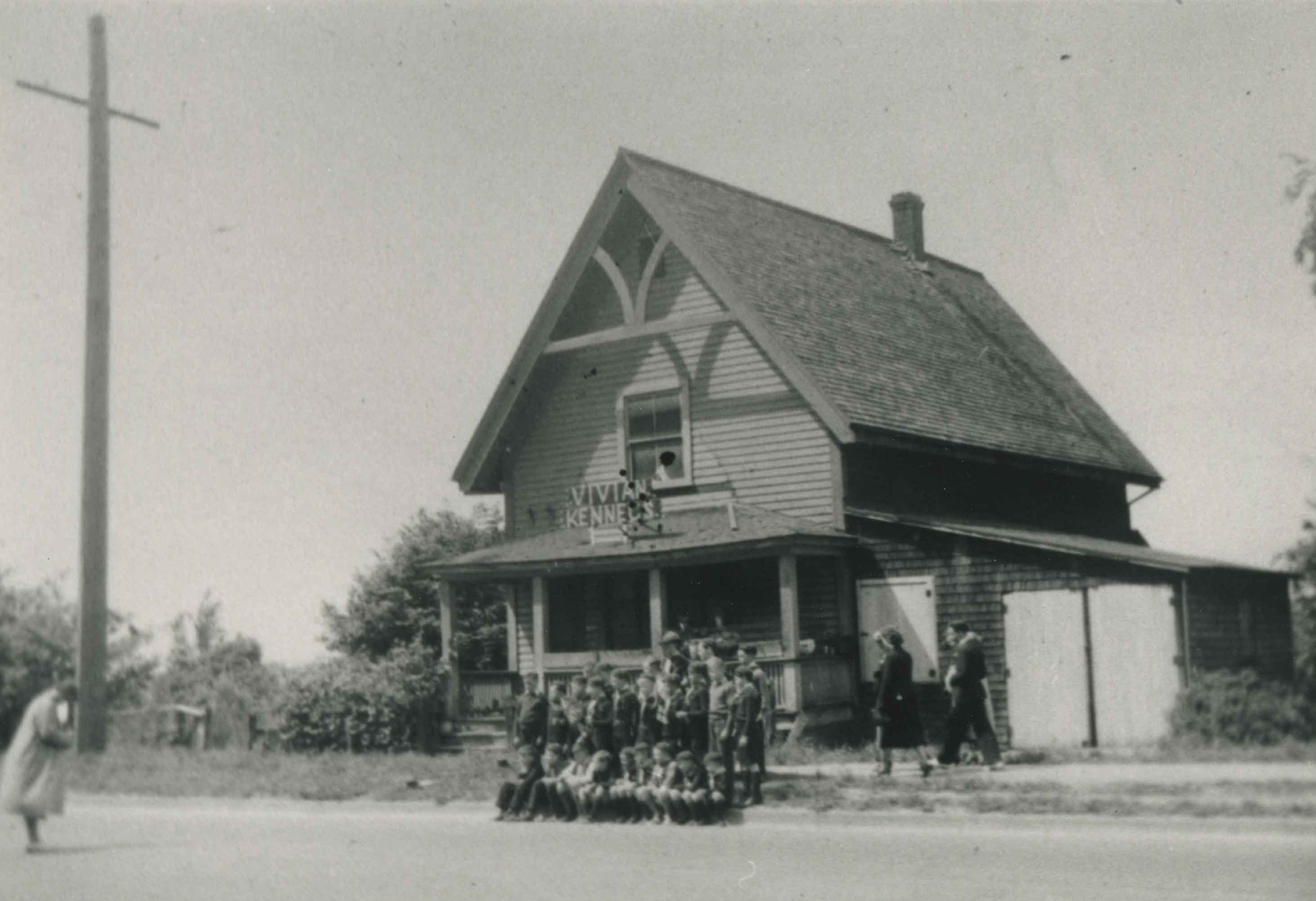
Old Presbyterian Church
https://search.heritageburnaby.ca/link/archivedescription38245
- Repository
- City of Burnaby Archives
- Date
- 1939
- Collection/Fonds
- Burnaby Historical Society fonds
- Description Level
- Item
- Physical Description
- 1 photograph : b&w ; 9 x 12.5 cm
- Scope and Content
- Photograph of approximately thirty young people posing for a picture on the sidewalk outside what has been labelled the old Presbyterian Church located at Kingsway, east of Boundary Road. A sign on the roof of the building reads "Vivian Kennels."
- Repository
- City of Burnaby Archives
- Date
- 1939
- Collection/Fonds
- Burnaby Historical Society fonds
- Subseries
- Margaret McCallum subseries
- Physical Description
- 1 photograph : b&w ; 9 x 12.5 cm
- Description Level
- Item
- Record No.
- 375-006
- Access Restriction
- No restrictions
- Reproduction Restriction
- No known restrictions
- Accession Number
- BHS1986-42
- Scope and Content
- Photograph of approximately thirty young people posing for a picture on the sidewalk outside what has been labelled the old Presbyterian Church located at Kingsway, east of Boundary Road. A sign on the roof of the building reads "Vivian Kennels."
- Subjects
- Buildings - Religious - Churches
- Media Type
- Photograph
- Notes
- Title based on contents of photograph
- Geographic Access
- Kingsway
- Historic Neighbourhood
- Central Park (Historic Neighbourhood)
- Planning Study Area
- Garden Village Area
Images
![Riverway East School and Dundonald Church, [between 1911 and 1919] thumbnail](/media/hpo/_Data/_Archives_Images/_Unrestricted/316/325-024.jpg?width=280)
Riverway East School and Dundonald Church
https://search.heritageburnaby.ca/link/archivedescription37152
- Repository
- City of Burnaby Archives
- Date
- [between 1911 and 1919]
- Collection/Fonds
- Burnaby Historical Society fonds
- Description Level
- Item
- Physical Description
- 1 photograph : b&w ; 8 x 12.5 cm print
- Scope and Content
- Photograph of Riverway East (renamed Dundonald) School and Dundonald Untied Church taken from River Road (now Marine Drive). A large pile of cordwood is visible alongside the school.
- Repository
- City of Burnaby Archives
- Date
- [between 1911 and 1919]
- Collection/Fonds
- Burnaby Historical Society fonds
- Subseries
- Disney family subseries
- Physical Description
- 1 photograph : b&w ; 8 x 12.5 cm print
- Description Level
- Item
- Record No.
- 325-024
- Access Restriction
- No restrictions
- Reproduction Restriction
- No known restrictions
- Accession Number
- BHS1996-04
- Scope and Content
- Photograph of Riverway East (renamed Dundonald) School and Dundonald Untied Church taken from River Road (now Marine Drive). A large pile of cordwood is visible alongside the school.
- Media Type
- Photograph
- Photographer
- Disney, John Harold "Jack"
- Notes
- Title based on contents of photograph
- Geographic Access
- Gilley Avenue
- Marine Drive
- Street Address
- 5787 Marine Drive
- Historic Neighbourhood
- Alta-Vista (Historic Neighbourhood)
- Planning Study Area
- Clinton-Glenwood Area
Images
![Riverway East School and Dundonald Church, [between 1911 and 1919] thumbnail](/media/hpo/_Data/_Archives_Images/_Unrestricted/316/325-024.jpg)