Narrow Results By
Creator
- Burnett and McGugan B.C. Land Surveyors, New Westminster 1
- Burnett, Geoffrey K. 1
- Burnett & McGugan, Engineers and Surveyors 2
- Carter, David 1
- Codd, Lisa 1
- Cooke, Rosemary 1
- Dominion Map and Blueprint Co. 2
- Draper, William Nelson 1
- Fong, Denise 1
- Garden, Hermon and Burwell 2
- Gauvreau, Narcisse B. 1
- Graham, Frank Duncan, 1875-1965 1

Rooted : Chinese Canadian stories in Burnaby
https://search.heritageburnaby.ca/link/museumlibrary7646
- Repository
- Burnaby Village Museum
- Collection
- Digital Reference Collection
- Material Type
- Digital Resource
- ISBN
- 978-0-9689849-2-5
- Call Number
- 971.133 ROO
- Contributor
- Fong, Denise
- Lemke, Jane
- Codd, Lisa
- Place of Publication
- Burnaby
- Publisher
- City of Burnaby
- Publication Date
- 2023
- Printer
- Metropolitan Fine Printers
- Physical Description
- 203 p. : ill. ; 30.5 cm
- Library Subject (LOC)
- Chinese Canadians--British Columbia--Burnaby--History
- Race discrimination -- Canada
- Subjects
- Persons - Chinese Canadians
- Agriculture
- Agriculture - Farms
- Persons - Families
- Rights
- Rights - Human Rights
- Social Issues
- Social Issues - Racism
- Notes
- There are two versions of the book: English and Simplified Chinese (left, below) and the other in English and Traditional Chinese (right, below).
- From the late 1800s to the present day, Chinese Canadians have made Burnaby into a more vibrant and livable city. Rooted: Chinese Canadian Stories in Burnaby brings together a collection of diverse stories and photographs from the community, celebrating the legacy and contributions of Burnaby’s Chinese Canadian community spanning over a century. This coffee-table book features oral histories and interviews with descendants of multigenerational family farms, green grocers, corner stores, restaurants, and places of worship. Also included are archival research and community perspectives on anti-Asian racism, community activism, courage, and resilience.
- The publication has been timed to coincide with the 100th anniversary of the introduction of the Chinese Exclusion Act by the Government of Canada in 1923. This federal legislation followed decades of discriminatory legislation by Canada’s federal, provincial and municipal governments that targeted Chinese Canadians by limiting opportunities to live, work and raise families in Canada. The Chinese Exclusion Act banned almost all migration from China and remained in place until 1947. Publishing this book in 2023 is an effort by the City of Burnaby to recognize the impact of discriminatory legislation on Chinese Canadians in our community, including discriminatory bylaws and practices implemented by Burnaby’s early municipal government.
- Edited by Denise Fong (Lead Researcher), Jane Lemke (Burnaby Village Museum Curator) and Lisa Codd (City of Burnaby Heritage Planner).
Images

Digital Books

Inkwells to Internet: A History of Burnaby Schools
https://search.heritageburnaby.ca/link/museumlibrary7551
- Repository
- Burnaby Village Museum
- Collection
- Reference Collection
- Digital Reference Collection
- Material Type
- Book
- ISBN
- 978-0-9781979-2-6
- Call Number
- 371 CAR
- Place of Publication
- Burnaby
- Publisher
- City of Burnaby
- Publication Date
- 2020
- Physical Description
- vii, 35 p. : ill. ; 29 cm.
- Library Subject (LOC)
- Burnaby (B.C.)--History
- Schools--British Columbia--Burnaby
- Subjects
- Education
- Notes
- "Includes index"
- A history of the Burnaby school district and individual school buildings in Burnaby, BC, between 1893 and 2013.
- The “First Nations cemetery” described on page 109 in Mary Johnson’s recollections was originally written as “Indian” and may refer to the Khalsa Diwan Society’s Sikh cremations at the Vancouver Cemetery.
Images

Digital Books
GVRD's MacLaren Engineers' Report Entitled "Waste Reduction and Recycling in the GVRD : A Blueprint for Comprehensive Resource Management, June 1989"
https://search.heritageburnaby.ca/link/councilreport12719
- Repository
- City of Burnaby Archives
- Report ID
- 12096
- Meeting Date
- 8-Aug-1989
- Format
- Council - Committee Report
- Collection/Fonds
- City Council and Office of the City Clerk fonds
- Repository
- City of Burnaby Archives
- Report ID
- 12096
- Meeting Date
- 8-Aug-1989
- Format
- Council - Committee Report
- Collection/Fonds
- City Council and Office of the City Clerk fonds
Documents
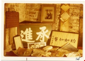
Framed signs with photographic portrait
https://search.heritageburnaby.ca/link/museumdescription9528
- Repository
- Burnaby Village Museum
- Date
- 1975
- Collection/Fonds
- Way Sang Yuen Wat Kee & Co. fonds
- Description Level
- Item
- Physical Description
- 1 photograph : sepia.; 9.9 x 13.6 cm
- Scope and Content
- Photograph of an arrangement of signs with Chinese characters and a portrait of Dr. Sun Yat-Sen inside Way Sang Yuen Wat Kee & Co., 1620 Government Street, Victoria. Commerically printed papers and blueprint are arranged on surface in front of signs.
- Repository
- Burnaby Village Museum
- Collection/Fonds
- Way Sang Yuen Wat Kee & Co. fonds
- Description Level
- Item
- Physical Description
- 1 photograph : sepia.; 9.9 x 13.6 cm
- Material Details
- "25" written on front right corner in black ink.
- Scope and Content
- Photograph of an arrangement of signs with Chinese characters and a portrait of Dr. Sun Yat-Sen inside Way Sang Yuen Wat Kee & Co., 1620 Government Street, Victoria. Commerically printed papers and blueprint are arranged on surface in front of signs.
- Accession Code
- BV017.7.338
- Access Restriction
- No restrictions
- Reproduction Restriction
- No known restrictions
- Date
- 1975
- Media Type
- Photograph
- Scan Resolution
- 600
- Scan Date
- 20-Aug-2018
- Notes
- Title based on contents of photograph
Images

Dial map of Greater Vancouver and Suburbs
https://search.heritageburnaby.ca/link/archivedescription65840
- Repository
- City of Burnaby Archives
- Date
- 1958
- Collection/Fonds
- Burnaby Historical Society fonds
- Description Level
- Item
- Physical Description
- 1 map : col. ; ink on sheet 55 x 73 cm folded to 28 x 14 cm
- Scope and Content
- Item is a Dial map of Greater Vancouver and Suburbs, published by Dominion Map and Blueprint Ltd. in Vancouver. Map includes both old and new street names.
- Repository
- City of Burnaby Archives
- Date
- 1958
- Collection/Fonds
- Burnaby Historical Society fonds
- Subseries
- Municipal record subseries
- Physical Description
- 1 map : col. ; ink on sheet 55 x 73 cm folded to 28 x 14 cm
- Material Details
- Scale : 1 1/4 inches = 1 mile
- Description Level
- Item
- Record No.
- 42695
- Access Restriction
- Open access
- Accession Number
- BHS1999-05
- Scope and Content
- Item is a Dial map of Greater Vancouver and Suburbs, published by Dominion Map and Blueprint Ltd. in Vancouver. Map includes both old and new street names.
- Media Type
- Cartographic Material
![Edmonds School trustees with architect and inspector, [between 1952 and 1956] thumbnail](/media/hpo/_Data/_Archives_Images/_Unrestricted/251/302-001.jpg?width=280)
Edmonds School trustees with architect and inspector
https://search.heritageburnaby.ca/link/archivedescription36578
- Repository
- City of Burnaby Archives
- Date
- [between 1952 and 1956]
- Collection/Fonds
- Burnaby Historical Society fonds
- Description Level
- Item
- Physical Description
- 1 photograph : sepia ; 19.5 x 24 cm
- Scope and Content
- Photograph of six men consulting blueprints outside in the snow at the site of the Edmonds Street School addition under construction. Standing in a row are;Trustee W. Maxwell, Architect Davies, Inspector Fredrickson, School Board Secretary Durkin, Trustee Samuel Norman Noble, and Principal Davis.
- Repository
- City of Burnaby Archives
- Date
- [between 1952 and 1956]
- Collection/Fonds
- Burnaby Historical Society fonds
- Subseries
- Photographs subseries
- Physical Description
- 1 photograph : sepia ; 19.5 x 24 cm
- Description Level
- Item
- Record No.
- 302-001
- Access Restriction
- No restrictions
- Reproduction Restriction
- Reproduce for fair dealing purposes only
- Accession Number
- BHS1992-43
- Scope and Content
- Photograph of six men consulting blueprints outside in the snow at the site of the Edmonds Street School addition under construction. Standing in a row are;Trustee W. Maxwell, Architect Davies, Inspector Fredrickson, School Board Secretary Durkin, Trustee Samuel Norman Noble, and Principal Davis.
- Subjects
- Buildings - Schools
- Construction
- Media Type
- Photograph
- Notes
- Title based on contents of photograph
- Handwritten note on verso of photograph identifies the individuals in the photograph and comments on them
- Copyright note: Images provided on this website are intended for research purposes only. Further use of any image is subject to the terms of the Copyright Act of Canada.
- Geographic Access
- 18th Avenue
- Street Address
- 7651 18th Avenue
- Historic Neighbourhood
- Edmonds (Historic Neighbourhood)
- Planning Study Area
- Edmonds Area
Images
![Edmonds School trustees with architect and inspector, [between 1952 and 1956] thumbnail](/media/hpo/_Data/_Archives_Images/_Unrestricted/251/302-001.jpg)
![Sectional map and street directory of Vancouver : Dial map of greater Vancouver including adjacent municipalities, [ca. 1950] thumbnail](/media/hpo/_Data/_BVM_Cartographic_Material/2000/2000_0003_0011_001%20WEB.jpg?width=280)
Sectional map and street directory of Vancouver : Dial map of greater Vancouver including adjacent municipalities
https://search.heritageburnaby.ca/link/museumdescription8697
- Repository
- Burnaby Village Museum
- Date
- [ca. 1950]
- Collection/Fonds
- Burnaby Village Museum Map collection
- Description Level
- Item
- Physical Description
- 2 maps and 1 p. of textual records on 1 sheet : lithographic prints, col. ; 55.5 x 75 cm + 2 dials and 25 x 72 cm + directory on sheet 55.5 x 75 cm, folded to 28.5 x 12.5 cm
- Scope and Content
- Item is a sectional map and street directory titled "Dial Map of Greater Vancouver and adjacent Municipalities" with a map on one side titled "Dial Map of Greater Vancouver and Suburbs" including Vancouver, West Vancouver, North Vancouver and Burnaby and includes street car and bus lines, railways,…
- Repository
- Burnaby Village Museum
- Collection/Fonds
- Burnaby Village Museum Map collection
- Description Level
- Item
- Physical Description
- 2 maps and 1 p. of textual records on 1 sheet : lithographic prints, col. ; 55.5 x 75 cm + 2 dials and 25 x 72 cm + directory on sheet 55.5 x 75 cm, folded to 28.5 x 12.5 cm
- Material Details
- Scales 1:42240, 1:144823
- 2 alphabetic dials on narrow strips of paper attached to map by grommets
- Scope and Content
- Item is a sectional map and street directory titled "Dial Map of Greater Vancouver and adjacent Municipalities" with a map on one side titled "Dial Map of Greater Vancouver and Suburbs" including Vancouver, West Vancouver, North Vancouver and Burnaby and includes street car and bus lines, railways, hospitals, parks, block nos. and street indexes with two alphabetic dials, one for Vancouver, the other for New Westminster. The other side of the map includes a map of "Fraser Valley" along with a directory of Vancouver street car and bus routes, business blocks, public buildings, hospitals, bathing beaches, locations of Vancouver fire halls and Vancouver city schools.
- Creator
- Dominion Map and Blueprint Co.
- Publisher
- Sectional Map and Street Directory Company
- Geographic Access
- Vancouver
- Accession Code
- BV000.3.11
- Access Restriction
- No restrictions
- Reproduction Restriction
- No known restrictions
- Date
- [ca. 1950]
- Media Type
- Cartographic Material
- Scan Resolution
- 380
- Scan Date
- 22-Dec-2020
- Scale
- 100
- Notes
- Title based on contents of map
Images
![Sectional map and street directory of Vancouver : Dial map of greater Vancouver including adjacent municipalities, [ca. 1950] thumbnail](/media/hpo/_Data/_BVM_Cartographic_Material/2000/2000_0003_0011_001%20WEB.jpg)


Landscape Plan Property of Dr. Blythe Eagles Esqr Burnaby BC \ F. E. Buck
https://search.heritageburnaby.ca/link/archivedescription66127
- Repository
- City of Burnaby Archives
- Date
- 1937
- Collection/Fonds
- Burnaby Historical Society fonds
- Description Level
- Item
- Physical Description
- 1 architectural drawing : blueprint ; 73 x 97 cm
- Scope and Content
- Item is a landscape plan for Dr Blythe and Violet Eagles' property at 3616 Sperling Avenue. This plan was designed by head of the Horticultural Department and the Campus Landscape Architect at U.B.C, Frank Ebenezer Buck.
- Repository
- City of Burnaby Archives
- Date
- 1937
- Collection/Fonds
- Burnaby Historical Society fonds
- Subseries
- Eagles family subseries
- Physical Description
- 1 architectural drawing : blueprint ; 73 x 97 cm
- Material Details
- Scale : 1 inch = 10 feet
- Description Level
- Item
- Record No.
- MSS055-051
- Accession Number
- BHS1991-18
- Scope and Content
- Item is a landscape plan for Dr Blythe and Violet Eagles' property at 3616 Sperling Avenue. This plan was designed by head of the Horticultural Department and the Campus Landscape Architect at U.B.C, Frank Ebenezer Buck.
- Media Type
- Architectural Drawing
- Notes
- Transcribed title
Wrigley's Official Arrow City map of Greater Vancouver and New Westminster
https://search.heritageburnaby.ca/link/archivedescription65838
- Repository
- City of Burnaby Archives
- Date
- 1936
- Collection/Fonds
- Burnaby Historical Society fonds
- Description Level
- Item
- Physical Description
- 1 map : blueprint ink on paper ; 60 x 85 cm folded to 25 x 11 cm in cover
- Scope and Content
- Item is Wrigley's Official Arrow City map of Greater Vancouver and New Westminster, published by Roy Wrigley Printing & Publishing Co. Ltd. in Vancouver. Map includes a street index of "Vancouver and [the] Lower Mainland." The maps shows main streets, bus lines, interurban lines, street car lines a…
- Repository
- City of Burnaby Archives
- Date
- 1936
- Collection/Fonds
- Burnaby Historical Society fonds
- Subseries
- Ephemera subseries
- Physical Description
- 1 map : blueprint ink on paper ; 60 x 85 cm folded to 25 x 11 cm in cover
- Material Details
- Scale : 1 inch = 3000 feet
- Cover is in col. and is attached to corner of map
- Description Level
- Item
- Record No.
- 42693
- Accession Number
- BHS1986-43
- Scope and Content
- Item is Wrigley's Official Arrow City map of Greater Vancouver and New Westminster, published by Roy Wrigley Printing & Publishing Co. Ltd. in Vancouver. Map includes a street index of "Vancouver and [the] Lower Mainland." The maps shows main streets, bus lines, interurban lines, street car lines and numbers.
- Media Type
- Cartographic Material
- Notes
- Interior map is entitled "Wrigley's NEW Map of Vancouver and Lower Mainland"
May Day invitation
https://search.heritageburnaby.ca/link/archivedescription57758
- Repository
- City of Burnaby Archives
- Date
- May 1933
- Collection/Fonds
- Burnaby Historical Society fonds
- Description Level
- Item
- Physical Description
- 1 invitation
- Scope and Content
- Item is an invitation addressed to Mr and Mrs G. Jeffery to attend the crowning of Ada Hatt as Burnaby's 1933 May Queen, beginning with the May Day procession and ending with dinner. The entire event was scheduled to take place on Saturday, May 20, 1933. This invitation was typed on Burnaby May Day…
- Repository
- City of Burnaby Archives
- Date
- May 1933
- Collection/Fonds
- Burnaby Historical Society fonds
- Subseries
- George Jeffery subseries
- Physical Description
- 1 invitation
- Description Level
- Item
- Record No.
- MSS013-007
- Accession Number
- BHS2007-04
- Scope and Content
- Item is an invitation addressed to Mr and Mrs G. Jeffery to attend the crowning of Ada Hatt as Burnaby's 1933 May Queen, beginning with the May Day procession and ending with dinner. The entire event was scheduled to take place on Saturday, May 20, 1933. This invitation was typed on Burnaby May Day Committee letterhead which includes a blueprint photograph and committee member names and positions.
- Media Type
- Textual Record
- Notes
- Title based on contents of item
Capitol Hill replotting - Sundry
https://search.heritageburnaby.ca/link/archivedescription1607
- Repository
- City of Burnaby Archives
- Date
- 1931-1933
- Collection/Fonds
- City Council and Office of the City Clerk fonds
- Description Level
- File
- Physical Description
- 2 folders textual records and cartographic material
- Scope and Content
- File contains records pertaining to the replotting of Capitol Hill, including a blueprint of sidewalk over tracks at Ardley, B.C. Also includes a draft of bylaw # 1452.
- Repository
- City of Burnaby Archives
- Date
- 1931-1933
- Collection/Fonds
- City Council and Office of the City Clerk fonds
- Physical Description
- 2 folders textual records and cartographic material
- Description Level
- File
- Record No.
- 3420
- Accession Number
- 2001-02
- Scope and Content
- File contains records pertaining to the replotting of Capitol Hill, including a blueprint of sidewalk over tracks at Ardley, B.C. Also includes a draft of bylaw # 1452.
- Media Type
- Textual Record
- Cartographic Material
- Notes
- Plans/maps are located in file and have not been moved to map case.
Permission to Vancouver Map and Blueprint Company Re: Compiling Large Scale Map of Municipality
https://search.heritageburnaby.ca/link/councilreport64279
- Repository
- City of Burnaby Archives
- Report ID
- 55457
- Meeting Date
- 10-Feb-1930
- Format
- Council - Committee Report
- Collection/Fonds
- City Council and Office of the City Clerk fonds
- Repository
- City of Burnaby Archives
- Report ID
- 55457
- Meeting Date
- 10-Feb-1930
- Format
- Council - Committee Report
- Collection/Fonds
- City Council and Office of the City Clerk fonds
Documents
Orders of Board of Railway Commission - Gilmore Avenue crossing
https://search.heritageburnaby.ca/link/archivedescription1485
- Repository
- City of Burnaby Archives
- Date
- 1928-1958
- Collection/Fonds
- City Council and Office of the City Clerk fonds
- Description Level
- File
- Physical Description
- 2 folders textual records and cartographic material
- Scope and Content
- Files contains white linen plan that accompanies railway application for highway crossing at Gilmore Avenue (1929) and 2 blueprint plans - one of the railway highway crossing protection at Bell and Sperling Avenue (1952) and the other at Bell and Douglas Avenue (1947).
- Repository
- City of Burnaby Archives
- Date
- 1928-1958
- Collection/Fonds
- City Council and Office of the City Clerk fonds
- Physical Description
- 2 folders textual records and cartographic material
- Description Level
- File
- Record No.
- 3296
- Accession Number
- 2001-02
- Scope and Content
- Files contains white linen plan that accompanies railway application for highway crossing at Gilmore Avenue (1929) and 2 blueprint plans - one of the railway highway crossing protection at Bell and Sperling Avenue (1952) and the other at Bell and Douglas Avenue (1947).
- Media Type
- Textual Record
- Cartographic Material
- Notes
- Plans/maps are located in file and have not been moved to map case.
West Burnaby sewerage correspondence
https://search.heritageburnaby.ca/link/archivedescription1364
- Repository
- City of Burnaby Archives
- Date
- 1926-1928
- Collection/Fonds
- City Council and Office of the City Clerk fonds
- Description Level
- File
- Physical Description
- Textual records and architectural drawings
- Scope and Content
- File includes an ink on white linen table titled "West Burnaby Sewers, Tabulation of Bids", and a blueprint of the same. Also included is an ink on white linen plan with some notations in pencil (1927)
- Repository
- City of Burnaby Archives
- Date
- 1926-1928
- Collection/Fonds
- City Council and Office of the City Clerk fonds
- Physical Description
- Textual records and architectural drawings
- Description Level
- File
- Record No.
- 3171
- Accession Number
- 2001-02
- Scope and Content
- File includes an ink on white linen table titled "West Burnaby Sewers, Tabulation of Bids", and a blueprint of the same. Also included is an ink on white linen plan with some notations in pencil (1927)
- Media Type
- Textual Record
- Architectural Drawing
- Notes
- Plans/maps are located in file and have not been moved to map case.
North Fraser Harbour Board - Financial statements, reports, bylaws
https://search.heritageburnaby.ca/link/archivedescription1390
- Repository
- City of Burnaby Archives
- Date
- 1926-1958
- Collection/Fonds
- City Council and Office of the City Clerk fonds
- Description Level
- File
- Physical Description
- 2 folders textual records and cartographic material
- Scope and Content
- File includes blueprint plan regarding foreshore application fronting.
- Repository
- City of Burnaby Archives
- Date
- 1926-1958
- Collection/Fonds
- City Council and Office of the City Clerk fonds
- Physical Description
- 2 folders textual records and cartographic material
- Description Level
- File
- Record No.
- 3198
- Accession Number
- 2001-02
- Scope and Content
- File includes blueprint plan regarding foreshore application fronting.
- Media Type
- Textual Record
- Cartographic Material
- Notes
- Plans/maps are located in file and have not been moved to map case.
Burnaby Sewer Construction Bylaw No. 500
https://search.heritageburnaby.ca/link/archivedescription1312
- Repository
- City of Burnaby Archives
- Date
- 1925 - 1926
- Collection/Fonds
- City Council and Office of the City Clerk fonds
- Description Level
- File
- Physical Description
- Textual records and architectural drawing
- Scope and Content
- File includes a blueprint chart as well as original newspaper clippings, bylaw # 462 and an oversized blueprint plan associated with DL 116, DL 121 and DL 187.
- Repository
- City of Burnaby Archives
- Date
- 1925 - 1926
- Collection/Fonds
- City Council and Office of the City Clerk fonds
- Series
- Bylaws series
- Physical Description
- Textual records and architectural drawing
- Description Level
- File
- Record No.
- 3114
- Accession Number
- 2001-02
- Scope and Content
- File includes a blueprint chart as well as original newspaper clippings, bylaw # 462 and an oversized blueprint plan associated with DL 116, DL 121 and DL 187.
- Notes
- A plan showing proposed sewer system and possible extensions DL 116 and parts of DL 121 and 187 : M9-A-8-2. A list of names of streets to be sewered and assessment of costs : M9-B-3-19
Road allowance - Sussex Avenue
https://search.heritageburnaby.ca/link/archivedescription1157
- Repository
- City of Burnaby Archives
- Date
- 1921
- Collection/Fonds
- City Council and Office of the City Clerk fonds
- Description Level
- File
- Physical Description
- Textual record and cartographic material
- Scope and Content
- File includes blueprint "Plan of 0.16 Acre Parcel of Block 11 DL 32, Group 1, New Westminster District", 1921.
- Repository
- City of Burnaby Archives
- Date
- 1921
- Collection/Fonds
- City Council and Office of the City Clerk fonds
- Physical Description
- Textual record and cartographic material
- Description Level
- File
- Record No.
- 2950
- Accession Number
- 2001-02
- Scope and Content
- File includes blueprint "Plan of 0.16 Acre Parcel of Block 11 DL 32, Group 1, New Westminster District", 1921.
- Media Type
- Textual Record
- Cartographic Material
- Notes
- Plans/maps are located in file and have not been moved to map case.

Map of Municipality of Burnaby
https://search.heritageburnaby.ca/link/museumdescription8200
- Repository
- Burnaby Village Museum
- Date
- 1921
- Collection/Fonds
- Burnaby Village Museum Map collection
- Description Level
- Item
- Physical Description
- 1 map : lithographic print, b&w ; 83 x 56 cm
- Scope and Content
- Item consists of a map of the Municipality of Burnaby compiled and published by Dominion Blueprint & Map Company.
- Repository
- Burnaby Village Museum
- Collection/Fonds
- Burnaby Village Museum Map collection
- Description Level
- Item
- Physical Description
- 1 map : lithographic print, b&w ; 83 x 56 cm
- Material Details
- Scale : 1:24,000 inches
- Scope and Content
- Item consists of a map of the Municipality of Burnaby compiled and published by Dominion Blueprint & Map Company.
- Creator
- Dominion Map and Blueprint Co.
- Publisher
- Blue Printers, Map Publishers and Draughtsmen
- Accession Code
- HV976.11.1
- Access Restriction
- No restrictions
- Reproduction Restriction
- No known restrictions
- Date
- 1921
- Media Type
- Cartographic Material
- Scan Resolution
- 340
- Scan Date
- 22 Dec. 2020
- Scale
- 100
- Notes
- Title based on contents of map
- Cardstock map cover reads: "Map / of the / Municipality of / Burnaby / Published by / Dominion Map & Blue Print Co. / Arts and Crafts Bldg /576 Seymour St., Vancouver, B.C. / Blue Printers, Map Publishers and Draughtsmen / Phone Sey 4670 / Price, 50 c."
- Title on map reads: "Burnaby / Municipality."
Zoomable Images


Commercial Map of Greater Vancouver and District
https://search.heritageburnaby.ca/link/museumdescription9552
- Repository
- Burnaby Village Museum
- Date
- July 1921
- Collection/Fonds
- Burnaby Village Museum Map collection
- Description Level
- Item
- Physical Description
- 1 map : col. lithograph mounted on linen ; 107 x 138 cm
- Scope and Content
- Commercial map of Greater Vancouver and District. Map depicts district lots, railroads, electric railways, streets, street car stops, schools, buildings, postal block numbers, parks and First Nations reserves. Map covers the geographcial areas of Vancouver, Burnaby, New Westminster, portions of Ric…
- Repository
- Burnaby Village Museum
- Collection/Fonds
- Burnaby Village Museum Map collection
- Description Level
- Item
- Physical Description
- 1 map : col. lithograph mounted on linen ; 107 x 138 cm
- Material Details
- Includes Legend and Index
- Scope and Content
- Commercial map of Greater Vancouver and District. Map depicts district lots, railroads, electric railways, streets, street car stops, schools, buildings, postal block numbers, parks and First Nations reserves. Map covers the geographcial areas of Vancouver, Burnaby, New Westminster, portions of Richmond, West Vancouver, North Vancouver, and Surrey with half mile circles that radiate from Vancouver City Hall on the corner of Main and Hastings. Bottom of map includes an index of street names, along with their corresponding map grid locations. The map is bordered by Marine Drive to the west, North Road to the east, Dempsey Street to the north and 20th Road to the south.
- History
- Bought by donor at thrift store years ago. No known provenance.
- Publisher
- Produced by Photo - Lithography, Colonist , Victoria, B.C.
- Geographic Access
- Vancouver
- Accession Code
- BV018.24.1
- Access Restriction
- No restrictions
- Reproduction Restriction
- No known restrictions
- Date
- July 1921
- Media Type
- Cartographic Material
- Scan Resolution
- 300
- Scan Date
- 16-Jun-20
- Scale
- 100
- Notes
- Transcribed title
- Title on map reads: "COMMERCIAL MAP / OF / GREATER VANCOUVER / AND / DISTRICT / Compiled and Published by / The Vancouver Map & Blueprint Co. Ltd. / 441 Seymour St. Vancouver B.C. / July, 1921".
Images

Road allowances - Patterson Avenue
https://search.heritageburnaby.ca/link/archivedescription1197
- Repository
- City of Burnaby Archives
- Date
- 1919-1920
- Collection/Fonds
- City Council and Office of the City Clerk fonds
- Description Level
- File
- Physical Description
- Textual records and cartographic material.
- Repository
- City of Burnaby Archives
- Date
- 1919-1920
- Collection/Fonds
- City Council and Office of the City Clerk fonds
- Physical Description
- Textual records and cartographic material.
- Description Level
- File
- Record No.
- 2993
- Accession Number
- 2001-02
- Media Type
- Textual Record
- Cartographic Material
- Notes
- See folder for a more detailed file inventory. Blueprint showing Patterson Avenue : M9-A-3-18.